The vegetation of the Coonavitra area, Paroo Darling ...
21
Cunninghamia: a journal of plant ecology for eastern Australia © 2011 Botanic Gardens Trust www.rbgsyd.nsw.gov.au/science/Scientific_publications/cunninghamia The vegetation of the Coonavitra area, Paroo Darling National Park, western New South Wales M. Westbrooke, S. Gowans and M. Gibson Centre for Environmental Management, University of Ballarat, PO Box 663 Ballarat, Victoria, 3353, AUSTRALIA. Abstract: The vegetation of Coonavitra area, Paroo Darling National Park (latitude 31°00’–32° 40’S and longitude 142°10’–144°25’E) in north western New South Wales was assessed using intensive quadrat sampling and mapped using extensive ground truthing and interpretation of aerial photograph and Landsat Thematic Mapper satellite images. In the survey 261 vascular plants species including 37 (14%) exotic species, from 50 families were recorded. Eighteen vegetation communities were identified and mapped, the most widespread being Casuarina pauper/Alectryon oleifolius low open woodland, Acacia loderi tall open shrubland, Flindersia maculosa low open woodland and Acacia aneura open-shrubland. Of particular significance are the extensive areas of Acacia loderi and Acacia melvillei tall open shrubland and one of the northernmost occurrences of Eucalyptus socialis tall open shrubland. Many of these communities have been impacted by a history of 150 years of pastoral use. Cunninghamia (2011) 12(1) 7–27 Introduction Paroo Darling National Park (lat 31° 00’–32 ° 40’S; long 142 ° 10’–144 ° 25’E) in north-western New South Wales, north-east of the town of Wilcannia (Fig. 1), covers an area of approximately 221,000 ha. The park, gazetted in October 2002, incorporates the previously gazetted Peery National Park with the addition of Mount Murchison, Wilga, Coonavitra and Tilpilly pastoral stations. As a result Paroo Darling National Park is made up of six separate non- contiguous areas (Fig. 1). The northernmost area is known as the Peery Lake area (and formerly Peery National Park) and is made up of the former pastoral stations of Peery, Mandalay and Arrow Bar. The Mount Murchison and Wilga areas are separated by the Darling River. The Coonavitra area, south-east of these areas, has a Northern block (north of the Barrier Highway) and a Southern block (south of the Barrier Highway). The southern block of Coonavitra is also referred to as the Emmdale block. The Tilpilly area between the Barrier Highway and the Wilcannia-Bourke Road is the eastern most extent of the park. Major features of the park are Peery Lake, part of the Paroo Overflow, and the rugged sandstone hills to the west of the lake. Other features are the Darling River that flows between the Mount Murchison and Wilga areas, and the rugged Greenough Hill range of the Northern block of Coonavitra. The study area falls within the Murray Darling Depression Bioregion. Detailed surveys and vegetation maps have been completed for the Peery Lake area (Westbrooke et al. 2002; Westbrooke et al. 2003) and the Tilpilly area (Hunter & Fallavollita 2003). In June and November 2005 an intensive vegetation survey of the Mount Murchison, Wilga and Coonavitra blocks, Paroo Darling National Park was conducted. Prior to this study no systematic survey of the vegetation of these Fig. 1. Location of Paroo Darling National Park
Transcript of The vegetation of the Coonavitra area, Paroo Darling ...

Cunninghamia: a journal of plant ecology for eastern Australia © 2011 Botanic Gardens Trustwww.rbgsyd.nsw.gov.au/science/Scientific_publications/cunninghamia
The vegetation of the Coonavitra area, Paroo Darling National Park, western New South Wales
M. Westbrooke, S. Gowans and M. Gibson
Centre for Environmental Management, University of Ballarat, PO Box 663 Ballarat, Victoria, 3353, AUSTRALIA.
Abstract: The vegetation of Coonavitra area, Paroo Darling National Park (latitude 31°00’–32° 40’S and longitude 142°10’–144°25’E) in north western New South Wales was assessed using intensive quadrat sampling and mapped using extensive ground truthing and interpretation of aerial photograph and Landsat Thematic Mapper satellite images. In the survey 261 vascular plants species including 37 (14%) exotic species, from 50 families were recorded. Eighteen vegetation communities were identified and mapped, the most widespread being Casuarina pauper/Alectryon oleifolius low open woodland, Acacia loderi tall open shrubland, Flindersia maculosa low open woodland and Acacia aneura open-shrubland. Of particular significance are the extensive areas of Acacia loderi and Acacia melvillei tall open shrubland and one of the northernmost occurrences of Eucalyptus socialis tall open shrubland. Many of these communities have been impacted by a history of 150 years of pastoral use.
Cunninghamia (2011) 12(1) 7–27
Introduction
Paroo Darling National Park (lat 31° 00’–32 ° 40’S; long 142 ° 10’–144 ° 25’E) in north-western New South Wales, north-east of the town of Wilcannia (Fig. 1), covers an area of approximately 221,000 ha. The park, gazetted in October 2002, incorporates the previously gazetted Peery National Park with the addition of Mount Murchison, Wilga, Coonavitra and Tilpilly pastoral stations. As a result Paroo Darling National Park is made up of six separate non-contiguous areas (Fig. 1). The northernmost area is known as the Peery Lake area (and formerly Peery National Park) and is made up of the former pastoral stations of Peery, Mandalay and Arrow Bar. The Mount Murchison and Wilga areas are separated by the Darling River. The Coonavitra area, south-east of these areas, has a Northern block (north of the Barrier Highway) and a Southern block (south of the Barrier Highway). The southern block of Coonavitra is also referred to as the Emmdale block. The Tilpilly area between the Barrier Highway and the Wilcannia-Bourke Road is the eastern most extent of the park.
Major features of the park are Peery Lake, part of the Paroo Overflow, and the rugged sandstone hills to the west of the lake. Other features are the Darling River that flows between the Mount Murchison and Wilga areas, and the rugged Greenough Hill range of the Northern block of Coonavitra. The study area falls within the Murray Darling Depression Bioregion.
Detailed surveys and vegetation maps have been completed for the Peery Lake area (Westbrooke et al. 2002; Westbrooke et al. 2003) and the Tilpilly area (Hunter & Fallavollita 2003). In June and November 2005 an intensive vegetation survey of the Mount Murchison, Wilga and Coonavitra blocks, Paroo Darling National Park was conducted. Prior to this study no systematic survey of the vegetation of these
Fig. 1. Location of Paroo Darling National Park

8 Cunninghamia 12(1): 2011 Westbrooke, Gowans & Gibson, Vegetation of Paroo Darling National Park
parts of the park had been done. Because of the contrasting landsystems represented, the results of the survey for the Mount Murchison and Wilga areas are presented separately from the Coonavitra area (Westbrooke et al. 2006). This paper details the findings of the vegetation survey for the Coonavitra area of Paroo Darling National Park.
History of the area
Prior to European settlement, nomadic Aboriginal tribes, who were able to travel away from permanent soaks, waterholes and native wells, inhabited the area after favourable rains. The Paakantji Aboriginal people travelled the length of the Darling River from Wilcannia through Menindee, towards Wentworth. The Ngiyeempaa people occupied the land south-east of the Darling River. The large number of middens and stone relics encountered today provide evidence of the
strong ties of both tribes to the river (H. Johnston, NSW Parks & Wildlife Service, Buronga, pers. comm.). The first Europeans to travel through the area were Charles Sturt and his party who followed the Darling River to Menindee and then travelled west to the Barrier Range and north into Queensland (Stanley 1991). Soon after, others followed the Darling River in search of pasture for sheep. Robert Gow explored the area in 1861 (Jervis 1948) but Vincent Dowling, who had established a cattle station close to the mouth of the Warrego River, had explored the Paroo River to the north-west in 1860 and applied for grazing rights (Heathcote 1965). The township of Wilcannia was surveyed in 1865 and soon thrived (Hardy 1969). Previously there was just a woolshed and a few huts at Mount Murchison Station. Soon after, 38 runs were taken up as Momba (848,000 ha.) which incorporated the existing Mount Murchison lease (Pickard 1990). Smith, Elder and Waite held the Momba pastoral
Relief & system Area Characteristics
Rolling downs and lowlands
Lilyvale (Lv) Emmdale block Undulating rounded quartzite and sandstone ridges, partly covered by aeolian sand, narrow incised drainage lines. Relief to 15m. Shallow, stony, loamy soils on upper slopes. Shallow to deep sands and red earths on lower slopes.
Plains
Coonavitra (Cv) Northern block Sandy accumulation on range footslopes, level Sandplain with wind-blown sand accumulation. Relief to 5m. Calcareous red earths with sandy surface.
Fulham (Fu) Emmdale block Plains with scattered dunes and small drainage sinks. Relief to 5m. Calcareous loamy or sandy slightly ferruginous red earths. Dunes of deep sands. Drainage sinks of calcareous red earths and some cracking clays.
Manara (Ma) Emmdale block Extensive plains with few dunes, low sandy accumulations and small drainage sinks. Relief to 5m. Calcareous red earths and solonised brown soils, with sands and sandy earths on dunes, and sandy earths or sandy texture-contrast soils on rises. Drainage sinks.
Nelia (Ne) Northern block & Emmdale block
Extensive plains with few dunes, and small and large drainage sinks. Relief to 5m. Level solonised brown soils, becoming slightly undulating near larger sinks, and some red-brown texture-contrast soils. Dunes of calcareous sandy earths or sands. Sinks of heavy clay or solonised brown soils.
Dunefields
Bell Vale (Bv) Emmdale block Dunefield with east-west orientated dunes, narrow to broad swales, and drainage sinks. Relief to 5m. Dunes of sands and sandy earths. Swales of calcareous red earths and reddish-brown clay soils. Drainage sinks of calcareous red earths and clay soils.
Blackfella (Bf) Emmdale block Sandplain with low east-west oriented dunes and few small drainage sinks. Relief to 3m. Sands and sandy earths. Few small open areas of calcareous red earths and clay soils.
Ranges
Boorandarra (Bz) Northern block Strongly bevelled quartzite and sandstone ridges and footslopes. Relief to 200m. Shallow, stony, sandy soils, becoming deeper and better developed downslope. Narrow valleys of red earths, incised channels.
Hills and footslopes
Mulga Downs (Mz) Northern block Low, partly bevelled quartzite and sandstone ridges and footslopes with narrow alluvial valleys. Relief to 50m. Shallow, stony, sandy soils, grading to deeper and better developed red earths downslope.
Playas and basins
Karumpito (Ko) Northern block & Emmdale block
Small lakes in red country with local catchments. Beds of cracking or non-cracking clays and solonised brown soils, with sandy surface deposits around shorelines. Lunettes of sandy solonised brown soils, often shallow overlying calcrete.
Table 1. Characteristics and occurrence of Land systems across the Coonavitra area (Walker 1972; Hazelton 1977)

Cunninghamia 12(1): 2011 Westbrooke, Gowans & Gibson, Vegetation of Paroo Darling National Park 9
lease from early 1870 (Heathcote 1965). In 1889 it was reported that Momba was overrun by kangaroos (Heathcote 1965). About this time a party of shooters found opal in the sandstone hills and by the 1890s White Cliffs township was established (Hardy 1969). With the development of pastoral leases in the 1850s, Aboriginal people were moved from their traditional homes to government missions at Menindee, Ivanhoe and Lake Cargelligo.
The combination of drought and overstocking made the normal recurrence of drought a major disaster. Whereas the land returned rapidly from ‘desert’ to ‘vital glory’ after the 1865–70 drought, this was no longer the case by the end of the century and by 1901 there was a catastrophic decline in productivity in the West Darling area. Sheep numbers that had gone from less than two million prior to 1880 to a peak of nearly eight million by 1894, had declined to less than three million again by 1901. After 1902, Momba was successively subdivided until around 1950 when the residue was divided into ten leases which included Peery, Mandalay and Arrow Bar (Pickard 1990).
Peery Station, the first of several pastoral properties to be acquired in the area, was identified as an area of particular conservation value and acquired in 1999 to protect natural and cultural heritage. Peery National Park was proclaimed in March 2000 (NPWS 2000) and the acquisition of Arrow Bar and Mandalay leases in December 2000 gave protection to the entire Peery Lake basin.
Coonavitra Station was part of the resumed area of the original Cultowa run. Colin Wheeler acquired the Coonavitra lease in 1947 and held it till his death in 1989 when his family sold parts of the lease. In June 2000 the National Parks and Wildlife Service acquired the remainder, followed by the Mount Murchison lease on the northern side of the Darling River. The subsequent purchase of Wilga Station, bordering Mount Murchison on the southern bank of the Darling, provided a link between the northern and southern properties and led to the proclamation of Paroo Darling National Park, incorporating what had previously been Peery National Park in October 2002.
Climate
The climate for the area is arid with low and unreliable rainfall (Edwards 1979). Temperatures are high in summer and mild in winter with average daily maximum of 35°C in January and 17°C in July and average daily minimum of 21°C in January and 4°C in July. The mean annual rainfall is approximately 250 mm and annual potential evaporation is 2738 mm. There is a slight summer bias to rainfall and annual variation is high (Clewett et al. 1994).
Geology and geomorphology
Three physiographic regions (Abraham 1991) occur within the Park; the Paroo plains of the eastern sector are separated from the Stony Tablelands and Plains by the Mount Pleasant sandstone hills (Morton 1991). The 12 land systems present (Milthorpe 1991) are summarised in Table 1.
The Northern block of Coonavitra supports a large expanse of sand plains in the south and the quartzite and sandstone Greenough Hill range in the north-west. The Emmdale block (Southern block) of Coonavitra supports extensive plains along with dunefields around the boundary with quartzite ridges near the southern boundary. Five land systems for the Northern block and seven land systems for the Emmdale block by are described Walker (1972) and Hazelton (1977) (Table 1). The distribution of the land systems across the Coonavitra area is shown in Fig. 2.
Previous studies
The most complete study of the vegetation of far western New South Wales is that by Beadle (1945; 1948) who included the study area as Casuarina pauper / Alectryon oleifolius subsp. canescens association along with claypans and swamps associated with the Darling River. Milthorpe (1991) and Pickard and Norris (1994) broadly describe the vegetation of the north-west corner of New South Wales, including the Peery Lake area of Paroo Darling National Park. Parts of the area now included in the Park were included in
Fig. 2. Distribution of land systems within Coonavitra section, Paroo Darling National Park (Key to codes used can be found in Table 1)

10 Cunninghamia 12(1): 2011 Westbrooke, Gowans & Gibson, Vegetation of Paroo Darling National Park
studies undertaken for the Wilderness Society (Lembit 1993; Knight 1994). A detailed survey and vegetation map have been completed for the Peery Lake area (Westbrooke et al. 2002; Westbrooke et al. 2003) and the Tilpilly area (Hunter & Fallavollita 2003). No systematic survey of the vegetation of Coonavitra had been undertaken prior to this study.
Methods
Study area
The Northern block of Coonavitra is approximately 95 km east of Wilcannia, north of the Barrier Highway and incorporates approximately 19,320 ha of the former Coonavitra Pastoral Station (the Coonavitra Homestead is 2 km north of the Barrier Highway; there are old yards and woolsheds just north of the Homestead). The study area takes in the Greenough Hill range. Following significant rain, a number of swamps and waterholes (Gulguy and Markaira Waterholes) hold water. Four named tanks (Bokara, Thoongama, Woolshed and Old Coonavitra), and two named bores (Bokara and Coolabah) (Fig. 3) were constructed for pastoral use prior to the park gazettal.
The Southern (Emmdale) block of Coonavitra is south of the Barrier Highway and incorporates 8,437 ha of the former Coonavitra Station (a number of old yards are scattered across the park). Several swamps hold water following significant rain and there are four named tanks (Hamton, Kurumpto and Eram), and one named bore (Bruton) constructed prior to park gazettal (Fig. 3).
Transect survey
A preliminary survey of vegetation communities within Coonavitra was undertaken in June 2005, following three years of drought. A transect-based sampling strategy was employed. Driven transects followed existing vehicle access tracks and fence lines, walked transects were across country. All transects were tracked using a Global Positioning System (GPS) receiver in the Australian Map Grid projection (Zone 54 and 55) and the 1984 World Geodetic System datum. The survey included approximately 205 km of walked and driven transects (Fig. 3). Vegetation communities along these transects were recorded and dominant perennial species listed for each community. A preliminary vegetation map at a scale of 1: 50,000 was prepared. Details of how information was collected along these transect and used to define vegetation communities are outlined below.
Fig. 3. Survey transects for the Coonavitra area Fig. 4. Quadrat locations for the Coonavitra area
Table 2. Modified Braun-Blanquet scale (Kershaw & Looney 1985
Scale Definition
+ Few individuals, less than 1% cover1 Any number of individuals, less than 5% cover2 Any number of individuals, 6–25% cover3 Any number of individuals, 26–50% cover4 Any number of individuals, 51–75% cover5 Any number of individuals, 76–100% cover
Cunninghamia 12(1): 2011 Westbrooke, Gowans & Gibson, Vegetation of Paroo Darling National Park 11
Quadrat survey
In November 2005 following good winter rainfall, a detailed floristic survey was undertaken. A quadrat-based sampling strategy was employed to survey the floristic composition of the vegetation communities. All quadrats were 900 m2 (30 m x 30 m) in size. The sampling strategy was based on the preliminary vegetation map prepared following the June survey. Communities were generally sampled in proportion to the area they covered but to enable characterisation of communities, those of limited distribution may have been relatively over-sampled. All quadrat locations were recorded using a Global Positioning System (GPS) receiver in the
Australian Map Grid projection (Zone 54 and 55) and the 1984 World Geodetic System datum. All vascular plant species occurring in each quadrat were recorded, identified to species level where possible and their conservation status determined. All flora were given a cover / abundance value, modified from Braun-Blanquet scale (as in Kershaw & Looney 1985) (Table 2).
The field survey was undertaken during early spring following good winter rains to take advantage of the opportunities for plant identification, particularly grasses, herbs and forbs. Some later spring-flowering grasses, herbs and forbs may have been dormant at this time and not observed. Similarly,
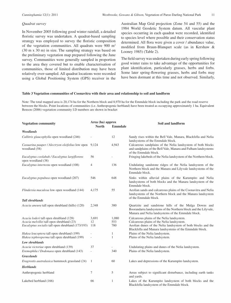
Vegetation community Area (ha) approx Soil and landformNorth Emmdale
Woodlands
Callitris glaucophylla open woodland (246) - 12 Sandy rises within the Bell Vale, Manara, Blackfella and Nelia landsystems of the Emmdale block.
Casuarina pauper / Alectryon oleifolius low open woodland (58)
9,124 4,943 Calcareous sandplains of the Nelia landsystem of both blocks and sandplains of the Bell Vale, Manara and Fulham landsystems of the Emmdale block.
Eucalyptus coolabah / Eucalyptus largiflorens open woodland (38)
56 - Fringing lakebeds of the Nelia landsystem of the Northern block.
Eucalyptus intertexta open woodland (108) 4 136 Undulating sandstone ridges of the Nelia landsystem of the Northern block and the Manara and Lilyvale landsystems of the Emmdale block.
Eucalyptus populnea open woodland (207) 546 648 Sinks within alluvial plains of the Karumpito and Nelia landsystems of both blocks and the Manara landsystem of the Emmdale block.
Flindersia maculosa low open woodland (144) 4,175 55 Aeolian sands and calcareous plains of the Coonavitra and Nelia landsystems of the Northern block and the Manara landsystem of the Emmdale block.
Tall shrublands
Acacia aneura tall open shrubland (hills) (120) 2,348 380 Quartzite and sandstone hills of the Mulga Downs and Boorandarra landsystems of the Northern block and the Lilyvale, Manara and Nelia landsystems of the Emmdale block.
Acacia loderi tall open shrubland (128) 3,691 1,080 Calcareous plains of the Nelia landsystem.Acacia melvillei tall open shrubland (23) 12 553 Calcareous plains of the Nelia landsystem.Eucalyptus socialis tall open shrubland (173/193) 118 780 Aeolian dunes of the Nelia landsystem of both blocks and the
Blackfella and Manara landsystems of the Emmdale block.Hakea leucoptera tall open shrubland (199) - 1 Plains of the Nelia landsystem.Hakea tephrosperma tall open shrubland (199) - 1 Plains of the Nelia landsystem.
Low shrublandsAcacia victoriae open shrubland (139) 37 - Undulating plains and dunes of the Nelia landsystem.Eremophila / Dodonaea open shrubland (143) - 340 Plains of the Nelia landsystem.
Grasslands
Eragrostis australasica hummock grassland (24) 1 60 Lakes and depressions of the Karumpito landsystem.
Herblands
Anthropogenic herbland 7 5 Areas subject to significant disturbance, including earth tanks and yards.
Lakebed herbland (166) 66 1 Lakes of the Karumpito landsystem of both blocks and the Blackfella landsystem of the Emmdale block.
Table 3 Vegetation communities of Coonavitra with their area and relationship to soil and landform
Note: The total mapped area is 20,174 ha for the Northern block and 8,970 ha for the Emmdale block including the park and the road reserve between the blocks. Point locations of communities (i.e. Anthropogenic herbland) have been treated as occupying approximately 1 ha. Equivalent Benson (2006) vegetation community I.D numbers are shown in bracket

12 Cunninghamia 12(1): 2011 Westbrooke, Gowans & Gibson, Vegetation of Paroo Darling National Park
earlier spring-flowering plants may have completed their growth cycles and may not have been observed. Where dead material (e.g. leaves, stems, seeds) was available such species were recorded to family, genus or species level where possible.
An estimate of the typical height and a visual estimate of the projected foliage cover of both native and introduced species in the tree layer, tall shrub layer (approximately > 1 m high), small shrub layer (approximately < 1 m high) and ground layer were recorded for each quadrat. Visual estimates of the total percentage cover of bare ground, cryptogams, litter, logs and rocks were recorded for each quadrat. All quadrats were photographed to provide a record of the appearance of the site but were not intended to provide permanent monitoring points. For the Coonavitra area 85 quadrats were sampled, 46 for the Northern block and 39 for the Emmdale block (Fig. 4).
The 1: 50,000 vegetation map produced following the June field survey was verified by ground checking the mapped boundaries of the vegetation communities via driven transects.
The map (Appendix 2) is also available on the Cunninghamia website.
Data analysis
Information from the transects was used in conjunction with colour aerial photographs (NSW Dept of Lands) and Landsat Thematic Mapper satellite imagery (Scene 95–83) to produce a vegetation map at 1: 50,000 scale. Vegetation mapping was undertaken using a combination of ArcGIS 9.0 and MapInfo Professional Version 7.5 Geographic Information Systems. The mapped vegetation communities were defined by floristic and structural characteristics (Specht 1970) coupled with expert judgment and analysis. The communities were then compared to those communities outlined in Benson (2006) to determine the equivalent vegetation community name and their conservation status.
Data from quadrats were entered into a Microsoft® Access 2002 database and analysed using PATN (Belbin 1993) to determine the communities present. Further restricted and/or interesting communities recorded during the field survey but not evident from the numeric classification were added to the final classification. Most communities identified from the vegetation classification were mapped at the 1:50,000
scale. Additional vegetation types of restricted occurrence or not evident from the classification were located as points on the map. A species list was compiled for the study area incorporating all vascular plant species recorded from quadrats and additional species recorded opportunistically. The flora list also identifies which vegetation community each of the species was recorded in. For each vegetation community, mean species richness, total species richness and mean numbers of introduced species per quadrat were calculated.
Results
Vegetation
The southern area of the Northern block of Coonavitra consists predominantly of Casuarina pauper / Alectryon oleifolius low open woodland with patches of Eucalyptus populnea and Eucalyptus largiflorens open woodland in low-lying areas. To the north is extensive Flindersia maculosa low open woodland on the sandplains surrounding the Greenough Hill range. The range supports Acacia aneura tall open shrubland. Extending along the north-western boundary of the block is a large expanse of Acacia loderi tall open shrubland. In the south-eastern corner of the block are a few patches of Eucalyptus socialis tall open shrubland.
The Emmdale block consists mostly of Casuarina pauper / Alectryon oleifolius low open woodland on the sandplain. The north of the block consists of Acacia loderi tall open shrubland and Acacia melvillei tall open shrubland with patches of Eucalyptus populnea open woodland in low-lying areas. Drainage lines support Eragrostis australasicus tussock grassland and fringing Eucalyptus populnea open woodland. South of this are areas of Eucalyptus socialis tall shrubland with Eucalyptus intertexta open woodland and Acacia aneura tall open shrubland on the rocky hills.
Eighteen communities were recognised and described for the Coonavitra area, 13 for the Northern block and 15 for the Emmdale block (Table 3). While several of these are of limited distribution they add significantly to the conservation values of the Park. Map 1 shows the distribution of each of the vegetation communities. The floristic composition of vegetation communities are outlined later in this section. A total list of flora species recorded for each vegetation community is provided in appendix 1.

Cunninghamia 12(1): 2011 Westbrooke, Gowans & Gibson, Vegetation of Paroo Darling National Park 13
Woodlands
Callitris glaucophylla open woodland
Small areas of Callitris glaucophylla open woodland (Fig. 5) occur on sandy rises in the south of the Emmdale block. Associated understorey shrubs include Dodonaea viscosa subsp. angustissima, Eremophila sturtii, Hakea tephrosperma, Enchylaena tomentosa, Sclerolaena obliquicuspis, Salsola kali var. kali, Chenopodium desertorum and Atriplex stipitata. Ground layer species include Rhodanthe corymbiflora, Austrostipa scabra, Gnephosis foliata and Harmsiodoxa brevipes var. brevipes.
Casuarina pauper / Alectryon oleifolius low open woodland
Casuarina pauper / Alectryon oleifolius low open woodland (Fig. 6) growing to 10–12 metres tall is widespread on undulating sandplains including a large area in the south of the Northern block. Most commonly associated understorey shrubs are Dissocarpus paradoxus, Sclerolaena obliquicuspis, Sclerolaena diacantha, Eremophila sturtii, Enchylaena tomentosa, Chenopodium desertorum, Chenopodium curvispicatum and Atriplex stipitata. Commonly associated ground layer species include Austrostipa scabra, Rhodanthe corymbiflora and Pycnosorus pleiocephala.
Eucalyptus coolabah / Eucalyptus largiflorens open woodland
Small areas of Eucalyptus coolabah / Eucalyptus largiflorens open woodland (Fig. 7) (10 m tall) occur on heavy soils surrounding lakes in the south of the Northern block. Understorey shrubs frequently associated include Dissocarpus paradoxus and Enchylaena tomentosa. Associated ground layer species include Pycnosorus pleiocephala, Rhodanthe floribunda and Plantago drummondii.
Eucalyptus intertexta open woodland
Eucalyptus intertexta open woodland (Fig. 8) (10 m tall) occurs on the sandy lower slopes of the sandstone hills located in the south of both blocks of the Coonavitra area. Alectryon oleifolius subsp. canescens is commonly associated. The shrubs Sclerolaena diacantha, Sclerolaena convexula, Eremophila sturtii, Eremophila longifolia, Dodonaea viscosa subsp. angustifolia and Chenopodium desertorum are frequently found within this community. Ground layer species frequently associated include Rhodanthe corymbiflora, Waitzia acuminata and Austrostipa scabra.
Fig. 5. Callitris glaucophylla open woodland
Fig. 6. Casuarina pauper / Alectryon oleifolius low open woodland
Fig 7. Eucalyptus coolabah / Eucalyptus largiflorens open woodland
Fig. 8. Eucalyptus intertexta open woodland

14 Cunninghamia 12(1): 2011 Westbrooke, Gowans & Gibson, Vegetation of Paroo Darling National Park
Eucalyptus populnea open woodland
This open woodland (10 m tall) dominated by Eucalyptus populnea subsp. bimbil (Fig. 9) is associated with drainage lines and depressions. Understorey shrub species frequently associated include Dissocarpus paradoxus, Eremophila sturtii, Atriplex stipitata, Enchylaena tomentosa, Dodonaea viscosa subsp. angustifolia and Sclerolaena obliquicuspis. Associated ground layer species include Austrostipa scabra, Pycnosorus pleiocephala, Einadia nutans, Rhodanthe floribunda and Rhodanthe corymbiflora.
Flindersia maculosa low open woodland
Low open woodland dominated by Flindersia maculosa (Fig. 10) occurs on low hills and sandplains. Alectryon oleifolius subsp. canescens and Apophyllum anomalum are frequently associated. Associated shrubs include Dissocarpus paradoxus, Sclerolaena obliquicuspis, Atriplex stipitata, Enchylaena tomentosa, Sclerolaena diacantha, Eremophila sturtii, Maireana pyramidata and Salsola kali var. kali. Ground layer species include Austrostipa scabra, Rhodanthe corymbiflora, Lepidium oxytrichum and Stenopetalum lineare.
Tall shrublands
Acacia aneura tall open shrubland (hills)
Tall open shrubland dominated by Acacia aneura (Fig. 11) occurs on the rocky hills of the Greenough Hill range in the Northern block and the central and southern section of the Emmdale Block. Associated shrubs include Sclerolaena convexula, Enchylaena tomentosa, Eremophila longifolia and Atriplex stipitata. Ground layer species include Rhodanthe corymbiflora, Austrostipa scabra, Ptilotus polystachyus var. polystachyus, Ptilotus atriplicifolius var. atriplicifolius, Lepidium oxytrichum, Daucus glochidiatus, Thyridolepis mitchelliana, Solanum ferocissimum, Stenopetalum lineare and Goodenia gracilis.
Acacia loderi tall open shrubland
Tall open shrubland dominated by Acacia loderi (Fig. 12) occurs over large areas of Coonavitra. Common associates are Casuarina pauper and Alectryon oleifolius subsp. canescens. Associated shrubs include Dissocarpus paradoxus, Atriplex stipitata, Enchylaena tomentosa, Eremophila sturtii, Eremophila longifolia and Sclerolaena obliquicuspis. Ground layer species include Rhodanthe corymbiflora, Austrostipa scabra, Pycnosorus pleiocephala, Gnephosis foliata and Einadia nutans.
Fig. 9. Eucalyptus populnea open woodland
Fig. 10. Flindersia maculosa low open woodland
Fig. 11. Acacia aneura tall open shrubland (hills)
Fig. 12. Acacia loderi tall open shrubland
Cunninghamia 12(1): 2011 Westbrooke, Gowans & Gibson, Vegetation of Paroo Darling National Park 15
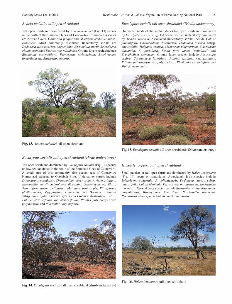
Acacia melvillei tall open shrubland
Tall open shrubland dominated by Acacia melvillei (Fig. 13) occurs in the north of the Emmdale block of Coonavitra. Common associates are Acacia loderi, Casuarina pauper and Alectryon oleifolius subsp. canescens. Most commonly associated understorey shrubs are Dodonaea viscosa subsp. angustifolia, Eremophila sturtii, Sclerolaena obliquicuspis and Dissocarpus paradoxus. Ground layer species include Rhodanthe corymbiflora, Pycnosorus pleiocephala, Brachyscome lineariloba and Austrostipa nodosa.
Eucalyptus socialis tall open shrubland (shrub understorey)
Tall open shrubland dominated by Eucalyptus socialis (Fig. 14) occurs on low aeolian dunes in the south of the Emmdale block of Coonavitra. A small area of this community also occurs east of Coonavitra Homestead adjacent to Coolabah Bore. Understorey shrubs include Dissocarpus paradoxus, Chenopodium desertorum, Atriplex stipitata, Eremophila sturtii, Sclerolaena diacantha, Sclerolaena parviflora, Senna form taxon ‘petiolaris’, Maireana pentatropis, Pittosporum phylliraeoides, Zygophyllum eremaeum and Dodonaea viscosa subsp. angustifolia. Ground layer species include Austrostipa scabra, Ptilotus atriplicifolius var. atriplicifolius, Ptilotus polystachyus var. polystachyus and Rhodanthe corymbiflora.
Eucalyptus socialis tall open shrubland (Triodia understorey)
On deeper sands of the aeolian dunes tall open shrubland dominated by Eucalyptus socialis (Fig. 15) occurs with an understorey dominated by Triodia scariosa. Associated understorey shrubs include Calotis plumulifera, Chenopodium desertorum, Dodonaea viscosa subsp. angustifolia, Halgania cyanea, Myoporum platycarpum, Sclerolaena diacantha, S. parviflora, Senna form taxon ‘petiolaris’ and Zygophyllum eremaeum. Ground layer species include Austrostipa scabra, Corynotheca lateriflora, Ptilotus exaltatus var. exaltatus, Ptilotus polystachyus var. polystachyus, Rhodanthe corymbiflora and Waitzia acuminata.
Hakea leucoptera tall open shrubland
Small patches of tall open shrubland dominated by Hakea leucoptera (Fig. 16) occur on sandplains. Associated shrub species include Sclerolaena convexula, S. obliquicuspis, Dodonaea viscosa subsp. angustifolia, Calotis hispidula, Dissocarpus paradoxus and Enchylaena tomentosa. Ground layer species include Austrostipa nitida, Rhodanthe corymbiflora, Brachyscome lineariloba, Bracteantha bracteata, Pycnosorus pleiocephala and Stenopetalum lineare.
Fig. 13. Acacia melvillei tall open shrubland
Fig. 14. Eucalyptus socialis tall open shrubland (shrub understorey)
Fig. 15. Eucalyptus socialis tall open shrubland (Triodia understorey)
Fig. 16. Hakea leucoptera tall open shrubland

16 Cunninghamia 12(1): 2011 Westbrooke, Gowans & Gibson, Vegetation of Paroo Darling National Park
Hakea tephrosperma tall open shrubland
Small patches of tall open shrubland dominated by Hakea tephrosperma (Fig. 17) occur on sandplains. Shrub associates include Dodonaea viscosa subsp. angustissima, Sclerolaena obliquicuspis, S. diacantha, Dissocarpus paradoxus and Chenopodium desertorum. Ground layer species include Pimelea trichostachya, Rhodanthe corymbiflora, Ptilotus polystachyus var. polystachyus and Austrostipa scabra.
Low shrublands
Acacia victoriae open shrubland
Acacia victoriae open shrubland (Fig. 18) occurs on sandy rises. Associated shrub species include Maireana brevifolia, Enchylaena tomentosa and Dissocarpus paradoxus. Ground layer species include Rhodanthe corymbiflora, Austrostipa scabra and Pycnosorus pleiocephalus.
Eremophila / Dodonaea open shrubland
On sandy rises are areas of mixed species shrubland in which Dodonaea viscosa subsp. angustissima and Eremophila sturtii are prominent (Fig. 19). This community is commonly associated with Casuarina pauper / Alectryon oleifolius low open woodland. Other associated
shrubs include Dissocarpus paradoxus, Einadia nutans, Chenopodium desertorum, Sclerolaena obliquicuspis, Sclerolaena muricata, Sclerolaena diacantha, Atriplex stipitata, Enchylaena tomentosa and Calotis hispidula. Common ground layer associates include Austrostipa trichophylla, Austrostipa scabra, Ptilotus atriplicifolius var. atriplicifolius, Ptilotus polystachyus var. polystachyus, Brachyscome lineariloba, Rhodanthe floribunda, Plantago turrifera, Harmsiodoxa brevipes var. brevipes and Stenopetalum lineare.
Grasslands
Eragrostis australasica grassland
Areas of Eragrostis australasica grassland (Fig. 20) occur in shallow lakes and in relic lakes within sandplains. Muehlenbeckia florulenta may be associated and other associated low shrubs and herbs include Pycnosorus pleiocephala, Lachnagrostis filiformis, Malva australiana, Rhodanthe corymbiflora, Sclerolaena tricuspis, Sclerolaena muricata, Plantago drummondii, Lepidium pseudohyssopifolium, Atriplex lindleyi and Myosurus minimus var. australis.
Fig. 17. Hakea tephrosperma tall open shrubland
Fig. 18. Acacia victoriae open shrubland
Fig. 19. Eremophila / Dodonaea open shrubland
Fig. 20. Eragrostis australasica grassland

Cunninghamia 12(1): 2011 Westbrooke, Gowans & Gibson, Vegetation of Paroo Darling National Park 17
Herblands
Anthropogenic herbland
Sites which had been subject to significant disturbance through the pastoral history of the properties, including homestead sites, earth tanks (Fig. 21) and yards had a predictably, high proportion of weed species.
Lakebed herbland
As the lakes dry out after flooding an annual herbland develops (Fig. 22). This is dominated by annuals including Scleroleana species. It is likely that the species composition of these areas is variable and dependant on seasonality of rainfall events, with grasses becoming more prominent following good summer rainfall. These herblands warrant a more detailed study through several seasons.
Plant species
A total of 261 vascular plant species from 50 families were recorded during this study of the Coonavitra area (appendix 1). Of the plant species recorded from the Park, 37 (14%) are introduced. The sampling effort in each vegetation community, mean and total native and introduced species richness is shown in Table 4.
Discussion
Mapping communities
There are a number of inherent problems in mapping vegetation: vegetation mapping assumes discontinuities between communities which may not exist; the constraints of cartography determine the minimum area that can clearly be distinguished; it is generally not feasible to groundtruth the whole of an area, thus parts of the map assume a consistent relationship between the vegetation and other features such as soil type and topography.
Beadle’s (1948) map of western NSW (at approximately 1:1 000 000 scale) includes two units for the Coonavitra area. James’s (1960) map of the Paroo-Upper Darling shows three vegetation units and Milthorpe (1991) 1:500 000 map of north western NSW shows five units. Pickard and Norris’s (1994) 1:1 000 000 map of north-western NSW shows nine. In our 1:50 000 scale map, 14 units are mapped and a further three indicated by point location. It was difficult to separate the two Eucalyptus socialis tall open shrubland communities (i.e. shrub understorey and Triodia understorey) and areas supporting Eucalyptus socialis tall open woodland are mapped as one unit. The map suffers from the limitations noted above. The smallest area that could be mapped was 100 m wide. Some areas remote from tracks may include small patches of a different vegetation unit from that mapped.
During the survey over 200 km of driven and walked transects were traversed, and given the association of many vegetation communities with landscape features, boundaries could be drawn with some confidence. Current mapping technology enables changes to be readily incorporated, and it is hoped that the map will be refined following further botanical survey.
Distribution of communities
The distribution and species composition of vegetation communities within Paroo Darling National Park is largely determined by variation in topography, landform position and soil type. Eucalypt species open woodlands are associated with texture contrast soils of the major creeklines. Shrubland dominated by Acacia aneura occurs on the lithosols of the quartzite and sandstone hills with Eucalyptus intertexta woodland on the red earths that occur on the footslopes. Woodlands variously dominated by Casuarina pauper, Acacia aneura and Flindersia maculosa occur on desert loams. Other factors, notably past grazing history, have also played a role in determining the present distribution and floristic composition of the communities present.
Vegetation condition
Whilst this was not intended to be a detailed assessment of vegetation condition, regeneration of overstorey and perennial understorey species was noted. Species richness
Fig. 21. Anthropogenic herbland
Fig. 22. Lakebed herbland

18 Cunninghamia 12(1): 2011 Westbrooke, Gowans & Gibson, Vegetation of Paroo Darling National Park
Vegetation communityNo. of
quads.
Native species richness
Introduced species
richnessMean Total Mean Total
WoodlandsCallitris glaucophylla open woodland 1 17.0 17 3.0 3Casuarina pauper / Alectryon oleifolius low open woodland 15 18.1 81 3.1 14Eucalyptus coolabah / Eucalyptus largiflorens open woodland 2 9.0 14 4.5 6Eucalyptus intertexta open woodland 5 18.6 56 2.8 10Eucalyptus populnea open woodland 8 15.1 47 4.1 10Flindersia maculosa low open woodland 9 19.8 69 3.6 12
Tall shrublandsAcacia aneura tall open shrubland (hills) 9 21.1 85 1.7 11Acacia loderi tall open shrubland 12 17.5 73 3.7 11Acacia melvillei tall open shrubland 2 19.5 31 7.0 10Eucalyptus socialis tall open shrubland (shrub understorey) 4 16.3 38 1.8 5Eucalyptus socialis tall open shrubland (Triodia understorey) 2 29.0 40 1.0 1Hakea leucoptera tall open shrubland 1 16.0 16 4.0 4Hakea tephrosperma tall open shrubland 1 15.0 15 3.0 3
Low shrublandsAcacia victoriae open shrubland 1 7.0 7 6.0 6Eremophila / Dodonaea open shrubland 2 15.5 26 4.5 5
GrasslandsEragrostis australasica hummock grassland 5 12.0 33 5.4 13
HerblandsAnthropogenic herbland 4 11.0 30 10.0 21Lakebed herbland 2 12.0 21 7.5 12
Vegetation community Area (ha)
approx
Equivalent Benson (2006)
vegetation community I.D
Conservation status (Benson 2006)
Woodlands
Callitris glaucophylla open woodland 12 246 Least ConcernCasuarina pauper / Alectryon oleifolius low open woodland 14,067 58 Near ThreatenedEucalyptus coolabah / Eucalyptus largiflorens open woodland 56 38 Least ConcernEucalyptus intertexta open woodland 140 108 Least ConcernEucalyptus populnea open woodland 1,194 207 Least ConcernFlindersia maculosa low open woodland 4,230 144 Near Threatened
Tall shrublands
Acacia aneura tall open shrubland (hills) 2,728 120 Near ThreatenedAcacia loderi tall open shrubland 4,771 128 Endangered (Threatened Species Conservation
Act 1995)Acacia melvillei tall open shrubland 565 23 Endangered (Threatened Species Conservation
Act 1995)Eucalyptus socialis tall open shrubland 898 173/193 Near Threatened/EndangeredHakea leucoptera tall open shrubland 1 199 Near ThreatenedHakea tephrosperma tall open shrubland 1 199 Near Threatened
Low shrublands
Acacia victoriae open shrubland 37 139 VulnerableEremophila / Dodonaea open shrubland 340 143 Least ConcernGrasslandsEragrostis australasica hummock grassland 61 24 Least ConcernHerblandsAnthropogenic herbland 12 N/A N/ALakebed herbland 67 166
Table 5. Conservation status of vegetation communities on Coonavitra based on Benson (2006)
Table 4. Sampling intensity, species richness and weediness of vegetation communities of the Coonavitra area
Cunninghamia 12(1): 2011 Westbrooke, Gowans & Gibson, Vegetation of Paroo Darling National Park 19
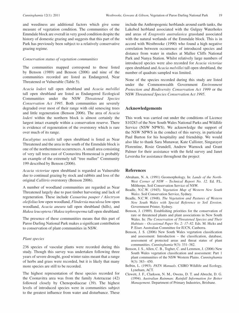
and weediness are additional factors which give some measure of vegetation condition. The communities of the Emmdale block are overall in very good condition despite the history of domestic grazing and suggests that this part of the Park has previously been subject to a relatively conservative grazing regime.
Conservation status of vegetation communities
The communities mapped correspond to those listed by Benson (1989) and Benson (2006) and nine of the communities recorded are listed as Endangered, Near Threatened or Vulnerable (Table 5).
Acacia loderi tall open shrubland and Acacia melvillei tall open shrubland are listed as Endangered Ecological Communities under the NSW Threatened Species Conservation Act 1995. Both communities are severely degraded over most of their range with old senescing trees and little regeneration (Benson 2006). The area of Acacia loderi within the northern block is almost certainly the largest intact example within a conservation reserve. There is evidence of regeneration of the overstorey which is rare over much of its range.
Eucalyptus socialis tall open shrubland is listed as Near Threatened and the area in the south of the Emmdale block is one of the northernmost occurrences. A small area consisting of very tall trees east of Coonavitra Homestead is probably an example of the extremely tall “tree mallee” Community 199 described by Benson (2006).
Acacia victoriae open shrubland is regarded as Vulnerable due to continual grazing by stock and rabbits and loss of the original Callitris overstorey (Benson 2006).
A number of woodland communities are regarded as Near Threatened largely due to past timber harvesting and lack of regeneration. These include Casuarina pauper / Alectryon oleifolius low open woodland, Flindersia maculosa low open woodland, Acacia aneura tall open shrubland (hills), and Hakea leucoptera / Hakea tephrosperma tall open shrubland.
The presence of these communities means that this part of Paroo Darling National Park makes a significant contribution to conservation of plant communities in NSW.
Plant species
236 species of vascular plants were recorded during this study. Though this survey was undertaken following three years of severe drought, good winter rains meant that a range of herbs and grass were recorded, but it is likely that many more species are still to be recorded.
The highest representation of these species recorded for the Coonavitra area was from the family Asteraceae (42) followed closely by Chenopodiaceae (39). The highest levels of introduced species were in communities subject to the greatest influence from water and disturbance. These
include the Anthropogenic herblands around earth tanks, the Lakebed herbland associated with the Gulguy Waterholes and areas of Eragrostis australasica grassland associated with the natural wetlands of the Emmdale block. This is in accord with Westbrooke (1990) who found a high negative correlation between occurrence of introduced species and distance from water in studies at Mallee Cliffs National Park and Nanya Station. Whilst relatively large numbers of introduced species were also recorded for Acacia victoriae open shrubland and Acacia melvillei tall open shrubland, the number of quadrats sampled was limited.
None of the species recorded during this study are listed under the Commonwealth Government Environment Protection and Biodiversity Conservation Act 1999 or the NSW Threatened Species Conservation Act 1995.
Acknowledgements
This work was carried out under the conditions of Licence S10283 of the New South Wales National Parks and Wildlife Service (NSW NPWS). We acknowledge the support of the NSW NPWS in the conduct of this survey, in particular Paul Burton for his hospitality and friendship. We would also like to thank Sara Munawar, Kate Callister, Singarayer Florentine, Rosie Grundell, Andrew Warnock and Grant Palmer for their assistance with the field survey and Janet Leversha for assistance throughout the project
References
Abraham, N. A. (1991) Geomorphology. In: Lands of the North-West Corner of NSW – Technical Report No. 12. Ed. P.L. Milthorpe, Soil Conservation Service of NSW.
Beadle, N.C.W. (1945). Vegetation Map of Western New South Wales. Soil Conservation Service, Sydney.
Beadle, N.C.W. (1948). The Vegetation and Pastures of Western New South Wales with Special Reference to Soil Erosion. Government Printer, Sydney.
Benson, J. (1989). Establishing priorities for the conservation of rare or threatened plants and plant associations in New South Wales. In: The Conservation of Threatened Species and Their Habitats – Occasional Paper No. 2: 17–82. Eds. M. Hicks and P. Eiser. Australian Committee for IUCN, Canberra.
Benson, J. S. (2006) New South Wales vegetation classification and assessment: Introduction – the classification, database, assessment of protected areas and threat status of plant communities. Cunninghamia 9(3): 331–382.
Benson, J. S., Allen, C. B., Togher, C. and Lemmon, J. (2006) New South Wales vegetation classification and assessment: Part 1 plant communities of the NSW Western Plains. Cunninghamia 9(3): 383– 450.
Belbin, L. (1993). PATN Manuals. CSIRO Wildlife and Ecology, Lyneham, ACT.
Clewett, J. F., Clarkson, N. M., Owens, D. T. and Abrecht, D. G. (1994). Australian Rainman: Rainfall Information for Better Management. Department of Primary Industries, Brisbane.

20 Cunninghamia 12(1): 2011 Westbrooke, Gowans & Gibson, Vegetation of Paroo Darling National Park
Edwards, K. (1979). Rainfall in New South Wales – With Special Reference to Soil Conservation – Technical Handbook No. 3. Soil Conservation Service of New South Wales, Sydney.
Hardy, B. (1969). West of the Darling. Rigby, Adelaide.Hazelton, P. (1977). Wilcannia Land Systems Series Sheet SH 54–
16. New South Wales, Soil Conservation Service.Heathcote, R. L. (1965). Back of Bourke: A Study of Land Appraisal
and Settlement in Semi-arid Australia. Melbourne University Press, Carlton.
Hunter, J. and Fallavollita, E. (2003). Vegetation and Floristics of Paroo Darling National Park – Thilta Karra Section. Report to the New South Wales National Parks and Wildlife Service.
James, J. W. (1960). Erosion survey of the Paroo-Upper Darling region. Part III. Journal of Soil Conservation Service of NSW 16: 185–206.
Jervis, J. (1948). The west Darling country: its exploration and development. Royal Australian Historical Society 34: 65–88.
Kershaw, K. A. and Looney, J. H. H. (1985). Quantitative and Dynamic Plant Ecology. Edward Arnold, Caufield East, Victoria.
Knight, R. (1994). Flora, Fauna and Wilderness Values of the Mount Glass and Peery Lake areas, Western New South Wales. Report by the Wilderness Society to the Australian Heritage Commission, Sydney.
Lembit, R. (1993). NSW Wilderness Review Stage II – Wilderness Area Investigation, Peery Lake and Mount Glass Study Areas – Botanical Survey Report. Report to the Wilderness Society, Sydney.
Milthorpe, P. L. (1991). Vegetation. In: Lands of the North–West Corner of NSW – Technical Report No. 12. Ed. P.L. Milthorpe, Soil Conservation Service of NSW.
Morton, J. G. G. (1991). Geology. In: Lands of the North-West Corner of NSW – Technical Report No. 12. Ed. P.L. Milthorpe, Soil Conservation Service of NSW.
NPWS (2000). File F/2835/vol. III – Peery. New South Wales National Parks and Wildlife Service.
Pickard, J. and Norris, E. H. (1994). The natural vegetation of north-western New South Wales: notes to accompany the 1:1 000 000 vegetation map sheet. Cunninghamia 3(3): 423–464.
Pickard, J. (1990). Analysis of stocking records from 1884 to 1988 during the subdivision of Momba, the largest property in semi-arid New South Wales. Proceedings of the Ecological Society of Australia 16: 245–253.
Specht, R. L. (1970). Vegetation. In: The Australian Environment. Ed. G. W. Leeper. Melbourne University Press, Melbourne.
Stanley, R. J. (1991). Land settlement and development. In: Lands of the North-West Corner of NSW – Technical Report No. 12. Ed. P. L. Milthorpe. Soil Conservation Service of NSW.
Walker, P. (1972). Barnato Land Systems Series Sheet SH 55–13. New South Wales, Soil Conservation Service.
Westbrooke, M. E. (1990). Effects of grazing pressure on weediness in mallee communities: studies at Mallee Cliffs National Park and Nanya Station, south-western New South Wales. In: The Mallee Lands: A Conservation Perspective. Eds J. C. Noble, P. J. Joss and G.K. Jones. CSIRO, Melbourne.
Westbrooke, M., Gowans, S., Gibson, M., Callister, K., Palmer, G., Florentine, S., O’Keefe, M., Warnock, A. and Grundell, R. (2006). The Vegetation of the Mount Murchison and Wilga areas, Paroo Darling National Park, Western New South Wales. Report prepared for the New South Wales National Parks and Wildlife Service by the Centre for Environmental Management, University of Ballarat.
Westbrooke, M., Leversha, J., Gibson, M., Milne, R., Gowans, S., Harding, C., Callister, K. and O’Keefe, M. (2002). The Vegetation of Peery National Park Western New South Wales. Report prepared for the New South Wales National Parks and Wildlife Service by the Centre for Environmental Management, University of Ballarat, Victoria.
Westbrooke, M., Leversha, J., Gibson, M., O’Keefe, M., Milne, R., Gowans, S., Harding, C. and Callister, K. (2003). The vegetation of Peery Lake area, Paroo Darling National Park, western New South Wales. Cunninghamia 8(1): 111–128.
Manuscript accepted 4 November 2010

Cunninghamia 12(1): 2011 Westbrooke, Gowans & Gibson, Vegetation of Paroo Darling National Park 21
Appendix 1: Flora species recorded within the Coonavitra area with frequency (%) of occurrence in communities
Nomenclature is according to Harden (1990–1993). * denotes introduced species.
Vegetation communities
Woodlands
1 Callitris glaucophylla open woodland2 Casuarina pauper / Alectryon oleifolius low open woodland3 Eucalyptus coolabah / Eucalyptus largiflorens open woodland4 Eucalyptus intertexta open woodland 5 Eucalyptus populnea open woodland6 Flindersia maculosa low open woodland
Tall shrublands
7 Acacia aneura tall open shrubland (hills)8 Acacia loderi tall open shrubland9 Acacia melvillei tall open shrubland10 Eucalyptus socialis tall open shrubland (shrub understorey)11 Eucalyptus socialis tall open shrubland (Triodia understorey)12 Hakea leucoptera tall open shrubland13 Hakea tephrosperma tall open shrubland
Low shrublands
14 Acacia victoriae open shrubland15 Eremophila / Dodonaea open shrubland
Grasslands
16 Eragrostis australasica hummock grassland
Herblands
17 Anthropogenic herbland18 Lakebed herbland
Vegetation communities
Taxon, family and name 1 2 3 4 5 6 7 8 9 10 11 12 13 14 15 16 17 18Number of quadrats 1 15 2 5 8 9 9 11 2 4 2 1 1 1 2 5 4 2
CONIFERSCupressaceae
Callitris glaucophylla 100 7 FERNS Adiantaceae Cheilanthes austrotenuifolia 33 Cheilanthes lasiophylla 22 Cheilanthes spp. 11 MONOCOTYLEDONS Amaryllidaceae Crinum flaccidum 13 Asphodelaceae* Asphodelus fistulosus 8 Bulbine alata 11 Bulbine bulbosa 11 25 Cyperaceae Eleocharis pallens 20 Phormiaceae Corynotheca lateriflora 100 Poaceae Aristida spp. 20 Austrostipa eremophila 20 Austrostipa nitida 7 13 22 17 100 Austrostipa nodosa 11 100 Austrostipa platychaeta 11 Austrostipa scabra 100 93 60 100 89 78 75 100 100 100 100 50 50

22 Cunninghamia 12(1): 2011 Westbrooke, Gowans & Gibson, Vegetation of Paroo Darling National Park
Vegetation communities
Taxon, family and name 1 2 3 4 5 6 7 8 9 10 11 12 13 14 15 16 17 18Number of quadrats 1 15 2 5 8 9 9 11 2 4 2 1 1 1 2 5 4 2
Austrostipa scabra ssp scabra 11 8 Austrostipa spp. 13 11 17 Austrostipa trichophylla 7 11 11 8 50 Brachyachne ciliaris 50 Elymus scaber var. scaber 7 11 Eragrostis australasica 100 Eragrostis dielsii 100 7 20 11 8 50 20 Eragrostis eriopoda 11 Eragrostis setifolia 20 13* Hordeum leporinum 7 50 25 11 100 100 80 50 100
Lachnagrostis filiformis 80 75 50 Monachather paradoxa 40 33* Schismus barbatus 47 100 20 25 33 100 50 50 Thyridolepis mitchelliana 40 44 Triodia scariosa 25 100* Vulpia muralis 20 11 20* Vulpia spp. 20 11 Xanthorrhoeaceae Lomandra spp. 50 DICOTYLEDONS Aizoaceae Tetragonia eremaea 7 11 17 20 50 Amaranthaceae Alternanthera nodiflora 20 Ptilotus atriplicifolius
var. atriplicifolius27 25 22 44 33 50 50 50 50
Ptilotus exaltatus var. exaltatus
20 11 50 25 100
Ptilotus gaudichaudii 11 Ptilotus gaudichaudii
var. goudchaudiii22
Ptilotus nobilis var. nobilis 13 Ptilotus polystachyus
var. polystachyus100 20 40 11 67 50 100 100 50
Apiaceae Daucus glochidiatus 44 50 Asclepiadaceae Leichardtia australis 7 20 11 11 8 Rhyncharrhena linearis 13 8 Asteraceae Actinobole uliginosum 7 50 Brachyscome ciliaris
var. lanuginosa11
Brachyscome lineariloba 33 38 22 11 25 100 50 100 100 50 50 Bracteantha bracteata 13 11 11 25 100 20 Calotis hispidula 20 22 100 50 Calotis plumulifera 7 20 100 Calotis scapigera 11 Calotis spp. 7 22 22 17 100 50* Carthamus lanatus 11 50* Centaurea melitensis 20 13 11 11 33 50 100 60 100 50 Centipeda cunninghamii 20 75 Centipeda spp. 25 Centipeda thespidioides 20 Chthonocephalus pseudevax 20* Cirsium vulgare 20 20 50 Euchiton spp. 25 Gnephosis foliata 100 27 13 22 11 42* Hedypnois rhagadioloides
ssp cretica25
Helipterum hyalospermum 11 Helipterum moschatum 7 50 Ixiolaena leptolepis 8 50* Lactuca serriola 25 Leucochrysum molle 11 Minuria cunninghamii 13 Minuria integerrima 20 Olearia pimeleoides 25 Pseudognaphalium luteoalbum 7 11 100 20 25 Pycnosorus pleiocephala 53 50 20 63 33 50 100 25 100 100 80 25 100 Pycnosorus pleiocephalus 20 13 22 25 100 20 Rhodanthe corymbiflora 100 60 100 50 78 100 100 100 50 100 100 100 100 60 25 100

Cunninghamia 12(1): 2011 Westbrooke, Gowans & Gibson, Vegetation of Paroo Darling National Park 23
Vegetation communities
Taxon, family and name 1 2 3 4 5 6 7 8 9 10 11 12 13 14 15 16 17 18Number of quadrats 1 15 2 5 8 9 9 11 2 4 2 1 1 1 2 5 4 2
Rhodanthe floribunda 13 50 50 11 8 50 75 Senecio glossanthus 13 20 25 Senecio quadridentatus 25 Senecio spp. 25* Sonchus asper
subsp. glaucescens8
* Sonchus oleraceus 11 50 Sonchus spp. 13 20 Vittadinia cuneata 20 11 11 50 Vittadinia dissecta 50 Vittadinia spp. 7 13 50 Waitzia acuminata 13 60 11 22 25 100* Xanthium spinosum 75 Boraginaceae* Echium plantagineum 100 7 20 11 22 8 100 20 100 50 Halgania cyanea 100 Heliotropium curassavicum 25 Heliotropium europaeum 25* Heliotropium supinum 25 Omphalolappula concava 7 Brassicaceae* Alyssum linifolium 13 50 38 22 25 100 100 100 20 50 Arabidella trisecta 20 8* Brassica tournefortii 100 47 60 50 56 22 17 100 75 100 100 100 100 80 50 50* Carrichtera annua 100 47 50 40 38 78 11 83 100 25 100 80 75 50 Harmsiodoxa brevipes
var. brevipes100 40 40 13 11 50 50
Lepidium hyssopifolium 20 25 Lepidium muelleri-ferdinandi 50 Lepidium oxytrichum 33 25 56 67 25 50 Lepidium papillosum 8 50 Lepidium pseudohyssopifolium 60 25 50 Lepidium spp. 7 33 20 50* Sisymbrium erysimoides 47 100 88 67 67 50 100 20 25 100* Sisymbrium irio 13 17 50 50* Sisymbrium orientale 7* Sisymbrium spp. 50 Stenopetalum lineare 20 20 25 44 44 17 50 25 100 50 Caesalpiniaceae Senna form taxon
‘artemisioides’7 20 22 8 50
Senna form taxon ‘coriacea’ 8 Senna form taxon ‘filifolia’ 7 20 11 25 Senna form taxon ‘petiolaris’ 11 17 50 100 Campanulaceae Wahlenbergia spp. 33 Capparidaceae Apophyllum anomalum 33 50 20 38 56 17 Caryophyllaceae* Spergularia rubra 7 25 11 25 40 25 50 Casuarinaceae Casuarina pauper 93 33 17 Chenopodiaceae Atriplex angulata 20 Atriplex eardleyae 50 50 Atriplex holocarpa 8 Atriplex limbata 27 50 20 13 11 25 50 Atriplex lindleyi 40 25 Atriplex spp. 7 13 80 Atriplex stipitata 100 47 20 75 78 56 75 50 75 50 25 Chenopodium cristatum 8 Chenopodium curvispicatum 47 20 13 22 11 33 50 Chenopodium desertorum 100 53 60 33 33 17 50 75 100 100 50 20 Chenopodium melanocarpum 7 Dissocarpus paradoxus 80 100 40 100 100 92 100 100 50 100 100 100 100 Einadia nutans 40 40 63 11 33 42 100 Enchylaena tomentosa 100 67 100 20 63 78 67 67 25 50 100 100 50 20 50 Maireana brevifolia 13 11 8 100 Maireana georgei 50 Maireana microcarpa 8 20 Maireana pentatropis 11 50 Maireana pyramidata 7 44 33 25

24 Cunninghamia 12(1): 2011 Westbrooke, Gowans & Gibson, Vegetation of Paroo Darling National Park
Vegetation communities
Taxon, family and name 1 2 3 4 5 6 7 8 9 10 11 12 13 14 15 16 17 18Number of quadrats 1 15 2 5 8 9 9 11 2 4 2 1 1 1 2 5 4 2
Maireana spp. 33 22 17 Maireana triptera 11 Maireana villosa 11 Salsola kali var. kali 100 33 25 44 25 50 50 100 Sclerochlamys brachyptera 8 Sclerochlamys spp. 25 Sclerolaena bicornis 11 Sclerolaena convexula 7 60 78 50 100 Sclerolaena decurrens 7 Sclerolaena diacantha 67 80 25 67 22 75 100 100 50 Sclerolaena divaricata 8 20 Sclerolaena intricata 7 11 17 50 50 Sclerolaena lanicuspis 17 Sclerolaena longicuspis 50 Sclerolaena muricata 11 50 40 50 50 Sclerolaena obliquicuspis 100 73 20 50 78 11 58 100 25 100 100 50 50 Sclerolaena parviflora 20 50 100 20 Sclerolaena spp. 50 11 8 50 Sclerolaena stelligera 11 Sclerolaena tricuspis 7 22 60 25 50 Convolvulaceae* Convolvulus arvensis 7 Convolvulus clementii 7 11 Convolvulus spp. 7 8 50 100 50 Crassulaceae Crassula colorata 8 Crassula spp. 27 13 8 50 Fabaceae* Medicago laciniata 53 100 40 100 33 33 92 100 25 100 100 100 100 60 50 100* Medicago minima 11 50 50* Medicago polymorpha 13 20 25 Templetonia aculeata 20 8 Templetonia egena 25 Gentianaceae* Centaurium spicatum 20* Centaurium tenuiflorum 7 Geraniaceae* Erodium cicutarium 11 50 Erodium crinitum 11 8 50 Erodium spp. 11 Goodeniaceae Goodenia cycloptera 100 Goodenia gracilis 44 20 Goodenia pinnatifida 20 22 Goodenia spp. 11 17 50 50 Haloragaceae Myriophyllum spp. 25 Myriophyllum verrucosum 50 Lamiaceae* Marrubium vulgare 25 Prostanthera striatiflora 33* Salvia verbenaca 7 20 8 50 100 75 Teucrium albicaule 8 Teucrium racemosum 7 38 75 Teucrium spp. 25 Lauraceae Cassytha spp. 20 Loranthaceae Amyema lucasii 56 Amyema miquelii 50 Amyema quandang var.
quandang25 11 33
Lysiana exocarpi 11 Malvaceae Abutilon calliphyllum 20 Abutilon fraseri 7 40 11 22 Abutilon spp. 11 8 Hibiscus sturtii spp. sturtii 20 Malva australiana 13 50 11 60 50 100* Malva parviflora 25

Cunninghamia 12(1): 2011 Westbrooke, Gowans & Gibson, Vegetation of Paroo Darling National Park 25
Vegetation communities
Taxon, family and name 1 2 3 4 5 6 7 8 9 10 11 12 13 14 15 16 17 18Number of quadrats 1 15 2 5 8 9 9 11 2 4 2 1 1 1 2 5 4 2
Sida cunninghamii 20 11 Sida intricata 7 40 33 17 50 50 Sida petrophila 11 Sida spp. 7 11 8 100 Mimosaceae Acacia aneura 13 20 22 100 50 Acacia colletioides 25 Acacia loderi 13 13 22 100 Acacia melvillei 11 100 Acacia oswaldii 13 20 11 Acacia tetragonophylla 22 Acacia victoriae 22 25 100 25 Myoporaceae Eremophila duttonii 11 Eremophila freelingii 11 Eremophila glabra 50 Eremophila goodwinii 20 Eremophila longifolia 60 22 67 42 25 50 Eremophila mitchellii 22 Eremophila serrulata 20 22 Eremophila spp. 20 13 22 8 25 Eremophila sturtii 100 67 80 100 67 33 58 50 75 Myoporum platycarpum 13 11 100 Myrtaceae Eucalyptus coolabah
subsp. coolabah50
Eucalyptus intertexta 100 Eucalyptus largiflorens 100 25 Eucalyptus populnea
subsp. bimbil50 100
Eucalyptus socialis 100 100 Oleaceae Jasminum lineare 20 Oxalidaceae Oxalis perennans 11 11 Oxalis spp. 50 Papaveraceae* Argemone ochroleuca
subsp. ochroleuca25
Pittosporaceae Pittosporum phylliraeoides 20 13 50 Plantaginaceae Plantago cunninghamii 13 Plantago drummondii 50 13 11 11 50 60 50 Plantago turrifera 20 20 22 33 50 Polygonaceae Muehlenbeckia florulenta 20 Rumex crystallinus 25 50 Proteaceae Grevillea huegelii 50 Hakea leucoptera 100 Hakea tephrosperma 100 100 Ranunculaceae Myosurus minimus
var. australis40
Rutaceae Eriostemon linearis 11 Flindersia maculosa 7 100 Geijera parviflora 7 Santalaceae Santalum acuminatum 7 Sapindaceae Alectryon oleifolius
subsp. canescens100 60 50 67 75 50 100 100 50
Atalaya hemiglauca 7 11

26 Cunninghamia 12(1): 2011 Westbrooke, Gowans & Gibson, Vegetation of Paroo Darling National Park
Vegetation communities
Taxon, family and name 1 2 3 4 5 6 7 8 9 10 11 12 13 14 15 16 17 18Number of quadrats 1 15 2 5 8 9 9 11 2 4 2 1 1 1 2 5 4 2
Dodonaea viscosa subsp. angustifolia
33 50 60 50 22 25 50 50 100 100 100
Dodonaea viscosa subsp. angustissima
100 13 20 22 11 8 25 100 25
Scrophulariaceae Stemodia florulenta 50 Solanaceae Lycium australe 11* Lycium ferocissimum 11 11* Nicotiana glauca 25 Nicotiana velutina 50 100 Solanum ellipticum 22 Solanum esuriale 11 17 Solanum ferocissimum 40 44 8 50 Solanum spp. 22 22 8 50 Thymelaeaceae Pimelea spp. 50 Pimelea trichostachya 100 13 11 100 Zygophyllaceae Zygophyllum ammophilum 7 11 25 Zygophyllum apiculatum 25 Zygophyllum aurantiacum 8 25 Zygophyllum eremaeum 7 20 13 22 11 17 50 50 100 Zygophyllum iodocarpum 50 Zygophyllum ovatum 7 25 Zygophyllum simile 7 Zygophyllum spp. 13 11 8