The University of Connecticut Center for Land Use...
24
Center for Land Use Education & Research Progress Report 2007 – 2012 The University of Connecticut
-
Upload
duongduong -
Category
Documents
-
view
214 -
download
0
Transcript of The University of Connecticut Center for Land Use...

Center for Land UseEducation & Research
Progress Report 2007 – 2012
The University of Connecticut

Contents
1 About CLEAR & This Report
1 The Need For CLEAR
2 Who Uses CLEAR & For What
3 What People Are Saying
4 Research
4 Changing Landscape
6 Geospatial Tools & Training
6 CT ECO (Environmental Conditions
Online)
8 Outreach Education
8 NEMO
10 National NEMO Network
11 Land Use Academy
12 Forestry
13 What We’re Working On—Right Now!
14 Grants & Funding
15 2012 Grants
16 Publications
18 Websites
19 Awards
About CLEAR
CLEAR Key Impacts
CLEAR Productivity
Contact Information
Acknowledgements
FSC logo here
Written and edited by Chester Arnold, CLEAR
Associate Director, Department of Extension, with
contributions from CLEAR principals.
Design and production management by Kara
Bonsack, CLEAR Graphic Designer, Department
of Extension.
Photography by Kara Bonsack, with the exception
of the photos noted below:
• Cover aerial, Tom Walsh, Shoreline Aerial
Photography
• Inside cover, rain garden install, David Dickson
• Page 3, training class, Cary Chadwick
• Page 6, computer training class, Susan Schadt
• Page 8, looking into manhole, Chester Arnold
• Page 9, pervious parking lot, Chester Arnold
• Page 11, training class, Cary Chadwick
• Page 12, students outdoors, Susan Schadt
• Page 12, chain saw class, Joel Stocker
• Page 13, rain garden install, David Dickson
This report is printed with vegetable oil-based inks
containing 70% bio renewable content; on 100%
postconsumer recycled, process-chlorine-free paper
using 100% windpower. This paper is certified by
Green Seal.

1
About CLEAR & This Report
The Need For CLEAR
The Center conducts
remote sensing
landscape research,
develops geospatial
tools and training
programs, and delivers
outreach educational
programs directly to
Connecticut communi-
ties and organizations.Connecticut is an urbanizing state, with a
population density in the top five in the
nation. With urbanization comes a host of
complex land use issues related to balancing
growth and natural resource protection.
Adding to this complexity is the fact that
land use in Connecticut is decided at the
local level, with the state’s 169 municipalities
each writing their own Plan of Conservation
and Development and developing their own
zoning, subdivision, and other regulations.
The boards that oversee the implementation
of these regulations are made up of citizen
volunteers, either elected or appointed, with
very little required training. UConn CLEAR
is the principal organization providing out-
reach education, technical training, web tools
and landscape information to these critically
important decision makers.
The mission of the University of Connecticut
Center for Land Use Education and Research
(CLEAR) is to provide assistance, education
and tools to Connecticut land use decision
makers, in support of their critical role in
determining the environmental, economic,
and social health of their communities. This
report contains recent highlights of major
projects undertaken by CLEAR faculty, as
well as summary information on Center
grants, publications, awards and other
accomplishments.
Although projects are categorized according
to the Center’s three main focus areas—
research, tools and training, and outreach
education—CLEAR takes pride in the inte-
gration of our programs and projects, and
on our strong focus on providing “real
world” assistance to decision makers across
Connecticut. The report covers the period
2007 – 2012, in some cases with background
information dating back to the formation of
CLEAR in 2002. CLEAR’s first five-year
progress report, can be viewed online at
clear.uconn.edu under “Publications.”
CLEAR provides a unique resource to the
communities and citizens of Connecticut and
has provided leadership and services to Land
Grant and Sea Grant colleagues across the
country. The Center conducts remote sensing
landscape research, develops geospatial tools
and training programs, and delivers outreach
educational programs directly to Connecticut
communities and organizations. CLEAR is
based in the College of Agriculture and
Natural Resources (CANR) and is a partner-
ship of the Department of Extension and
the Department of Natural Resources and
the Environment, both part of CANR, and
the Connecticut Sea Grant College Program.
CLEAR is a small center with a present size
of 7 faculty and 1 staff and an annual budget
of $500,000 to $1 million. 60 – 70% of the
Center budget comes through competitive
external grants. Since its formation in 2002,
CLEAR has obtained about 150 such grants,
totaling $13.2 million; approximately 88%
of these grants were from federal sources.
Virtually the entire budget of the Center
goes toward supporting “soft money” faculty
and staff, many of whom have built statewide
and even national reputations.

2
About CLEAR
In the Fall of 2012 CLEAR sent out a survey
to various Center contact lists, including
planners and local land use commissioners in
all 169 towns in Connecticut, for the purpose
of assessing which CLEAR programs,
information and tools were being used, and
for what.
WhoThere were 238 respondents from 87
Connecticut towns, 10 other states, and 25
regional or state organizations. Respondents
represented a balanced distribution of differ-
ent sectors (Figure 1).
What• The Land Use Academy (page 11) and
NEMO (page 8) had the highest name
recognition among CLEAR programs.
• Changing Landscape (page 4) online
maps and the online Low Impact
Development Atlas (page 10) had the
highest name recognition among CLEAR
projects.
• CT ECO (page 6) had the highest number
of people reporting that they use it “all
the time.”
WhyOur clients use CLEAR to educate them-
selves, educate others, for research, and to
inform land use plans and policies (Figure 2).
Some of the specific uses reported appear
in the box, below.
Who Uses CLEAR, & For What
20%
26%
31%
23%
(Figure 2) What our clients use CLEAR for
(Figure 1) Survey respondents
• Plan of Conservation &
Development Updates
(many responses)
• Assess impact to natural
resources & conduct
enforcement investigation
• Educate commissioners
(many responses)
• Learn about low impact
development (LID) (many
responses)
• Analyze watershed charac-
teristics
• Support approaches in
other states
• Support state land use
policies & programs
• Use geospatial information
for site interpretations for
conservation research,
planning, & management
• Develop open space rec-
ommendations for future
planning & acquisition
• Supplement geographic
information systems (GIS)
layers
• A model for university-
based land use education
programs
• Natural hazards mitigation
plan
• Regional Plan of
Conservation &
Development
• Inform policy decisions
• Support grants & conser-
vation planning
• Wetland application review
(more reliable than town
map)
• Research for amending
regulations
Using CLEAR (as reported in our survey)
Educate Myself
Educate Others
Inform Local Land Use Decisions
Analysis and/or Research
0 10 20 30 40 50 60 70 80
70%
50%
57%
56%

3
CLEAR provides assistance, education and
tools to Connecticut land use decision makers,
in support of their critical role in determining
the environmental, economic, and social
health of their communities.
“You are all Awesome. You are on the pulse
of what is needed and find a way to consis-
tently deliver. Your staff and leadership
are top notch and we are so lucky to have
you in our state.”
“I am a huge fan of CLEAR because you
provide resources and approaches that
would not be there otherwise.”
“CLEAR is absolutely essential to
understanding the health and well-being
of Connecticut’s communities and
ecosystems, particularly coastal, riverfront
and watershed towns. It provides on-demand
valuable tools that decision-makers can
access and use locally.”
“I have presented on non-point source pol-
lution and watershed management issues
around the country over the years and have
been proud to say that I am from
Connecticut since it is so highly recog-
nized due to its groundbreaking NEMO
program and research projects such as the
Jordan Cove project.”
“There are so many intangibles I gain
from CLEAR beyond the terrific resources
the staff have created. These include network-
ing, ideas on approaches to sometimes diffi-
cult topics and audiences, inspiration, updates
on new technologies, and how to build
model outreach programs and information.”
“Two decades of success in providing
great resource information and planning
tools to municipalities and local land man-
agers ... The wildlife and natural resources
of Connecticut are better off since you’ve
been here.”
“I think CLEAR is an amazing organi-
zation with a wonderful, talented staff,
that provides a critical service to residents,
municipalities, land use planners, agen-
cies, NGOs in Connecticut (and outside of
it too). Keep up the great work!”
“CLEAR is one of the most important
sources of information and training not
only to Connecticut residents, but to
stormwater educators across New England
and the rest of the country.”
“The combination of your expertise and
continued creativity is impressive and results
in great and usable products.”
“Very good organization. Every training has
been professional with great information.
A resource I wish I had known about long
ago. Will be using more and more. Keep it
up!”
“You are the best!! We appreciate your con-
tinuing efforts to advance science and land
use tools in planning and land use.”
“CLEAR and NEMO have been very
effective and efficient ways to get natural
resource information to local land man-
agers; keep up the good work!”
“I have extensively used the CLEAR infor-
mation and hope it continues in its friendly,
simple to use format. VERY useful infor-
mation, both from a commissioner’s
point of view and toward
creating/updating a POCD. Wish it was
more well known ...”
What People Are Saying (from our survey)
“You are on the pulse of
what is needed and find
a way to consistently
deliver. Your staff and
leadership are top notch
and we are so lucky to
have you in our state.”

The Changing Landscape information has
informed decision making by a wide variety
of organizations, in a number of different
ways:
• Local Planning: Landscape and landscape
change information provide a unique
way for a town to look at its current status
and growth patterns. CL maps and data
are a common component of municipal
Plans of Conservation and Development.
• State Regulation: CL data on impervious
surfaces were used by the Connecticut
Department of Energy and
Environmental Protection (CT DEEP)
to provide the foundation for their
impervious cover TMDL water regulation
for Eagleville Brook—the first of its kind
in the nation (see page 8). Similarly, CL
riparian land cover data was used by CT
DEEP in the development of a statewide
bacteria TMDL regulation.
• Research and Education: Faculty at
UConn, Yale, Wesleyan, Trinity and other
institutions of higher learning use CL
information for research and/or as a
Research
4
CLEAR Key Impacts
Changing Landscape Supports Policies
& Decisions at All Levels
CLEAR research focuses primarily on using
remote sensing science to map and quantify
changes to Connecticut’s landscape. The
Changing Landscape (CL) project is a nation-
ally unique project that charts these changes
over a 25-year period, from 1985 to 2010.
The CL project has given rise to several
related projects that use the land cover data
to look at specific geographic areas such as
riparian (streamside) corridors (image, lower
right), or natural resource issues such as
forest fragmentation (image, top right).
These data are then turned into accessible
and useful information, which is provided
in multiple forms on the CL website as
maps, tables, charts and downloadable data.
on the web at: clear.uconn.edu/projects/landscape

teaching tool in classes related to land-
scape architecture, environmental studies,
and geospatial science.
• State Planning and Monitoring: CL
land cover data provide a key information
layer for the State Plan of Conservation
and Development, currently under
development by the Connecticut Office
of Policy and Management. The
Connecticut Council on Environmental
Quality, a watchdog and monitoring
organization created by the Legislature,
uses CL land cover, forest fragmentation
and agricultural lands analyses to help
track Connecticut’s environmental
progress.
• Regional Environmental Assessment:
The federal/state partnership Long Island
Sound Study funded CLEAR to expand
the CL project to include Westchester
County and the Long Island portions of
the Long Island Sound watershed. The
project allows study researchers and
managers to help track progress of several
elements in its Comprehensive
Conservation and Management Plan.
• National Data Creation: The NOAA
Coastal Service Center used the CL
website as the model for their Coastal
Land Cover Atlas, a national web tool
showing land cover change in all coastal
states. As part of its creation, NOAA
CSC also ran the CLEAR Forest
Fragmentation model on its national
land cover dataset, and have made the
resultant maps and data available inter-
actively through the Atlas.
• Private Sector Partnerships:
Placeways, Inc. incorporated CLEAR’s
Forest Fragmentation tool into its popular
CommunityViz© planning software,
which is used by organizations all around
the world.
5
Riparian land cover for a portion of the central Connecticut coast. The land cover is shown for 300 feet to either
side of streams and water bodies. (Green is forest, red is developed, yellow is turf/grass, brown is agriculture.)
“Outstanding job of taking complex technical information and making it clear to municipal officials
and those who educate decision-makers on land use and stormwater management.”
Example of a forest fragmentation map.
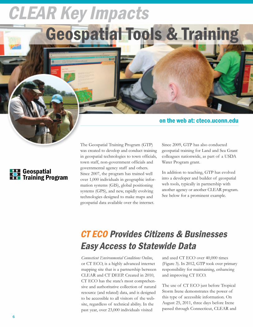
Connecticut Environmental Conditions Online,
or CT ECO, is a highly advanced internet
mapping site that is a partnership between
CLEAR and CT DEEP. Created in 2010,
CT ECO has the state’s most comprehen-
sive and authoritative collection of natural
resource (and related) data, and is designed
to be accessible to all visitors of the web-
site, regardless of technical ability. In the
past year, over 23,000 individuals visited
and used CT ECO over 40,000 times
(Figure 3). In 2012, GTP took over primary
responsibility for maintaining, enhancing
and improving CT ECO.
The use of CT ECO just before Tropical
Storm Irene demonstrates the power of
this type of accessible information. On
August 25, 2011, three days before Irene
passed through Connecticut, CLEAR and
Geospatial Tools & Training
6
CLEAR Key Impacts
CT ECO Provides Citizens & Businesses
Easy Access to Statewide Data
The Geospatial Training Program (GTP)
was created to develop and conduct training
in geospatial technologies to town officials,
town staff, non-government officials and
governmental agency staff and others.
Since 2007, the program has trained well
over 1,000 individuals in geographic infor-
mation systems (GIS), global positioning
systems (GPS), and new, rapidly evolving
technologies designed to make maps and
geospatial data available over the internet.
Since 2009, GTP has also conducted
geospatial training for Land and Sea Grant
colleagues nationwide, as part of a USDA
Water Program grant.
In addition to teaching, GTP has evolved
into a developer and builder of geospatial
web tools, typically in partnership with
another agency or another CLEAR program.
See below for a prominent example.
on the web at: cteco.uconn.edu

CT DEEP sent out a message to municipal
and agency mailing lists calling their atten-
tion to the Hurricane Surge Inundation
maps available on CT ECO (lower right).
In the days to come, CT ECO received
about twice as many visits as normal
(about 400 per day)—until the storm
knocked out power to many areas. Below
are some comments from CT ECO users:
Boat Owner: “Once again, beautiful and
timely! The [CT ECO] site helped me
decide it was safe to pull my boat out
at our marina at Pine Island marina, given
NOAA predicted storm surge, and the
inundation maps, rather than having to
drive it to the Connecticut river for haul
out. Thanks for your continued fantastic
work!”
Municipal GIS Manager: “I just want to
pass along to you ... that the town of Old
Saybrook used the SLOSH data down-
loaded from the [CT ECO] website to
prepare maps, in anticipation of Hurricane
Irene, showing the Category 1 and 2 inun-
dation areas. The maps were distributed
to emergency response organizations
and were used to help identify neigh-
borhoods to evacuate and to highlight
potential flooding of evacuation routes.
The town’s building official and a member
of the Old Saybrook Fire Department told
me that the maps were mostly accurate
and extremely useful. I know you do a lot
to help make GIS data available to com-
munities and thought you’d like to hear
back that it is very useful—was invaluable
in this particular case.”
State Emergency Operations Center
Geolab: “The CT ECO services were
very helpful for me during Irene. It was
nice to have that info available without
having to muck around with setting the
data up ... We use the image services every
day with our work ... We know we can
be confident that you folks, as stewards
of the data, have the best and latest
there.”
7
“CLEAR is absolutely essential to understanding the health and well-being of Connecticut’s communities
and ecosystems, particularly coastal, riverfront and watershed towns. It provides on-demand valuable
tools that decision-makers can access and use locally.”
“This was the best hands-on class of this kind I’ve taken! Can’t wait to see the technology evolve and come
to another class.”
A map from CT ECO showing the results of a NOAA Hurricane Surge Inundation model for the Old Saybrook
area. Green (category 1), dark green (category 2), yellow (category 3) and maroon (category 4) overlays show
that much of Old Saybrook south of I-95 would be flooded in a major hurricane.
0
10,000
20,000
30,000
40,000
2010
2011
2012
Unique Visitors
Total Visits
(Figure 3) CT ECO website use

Outreach Education
8
CLEAR Key Impacts
CLEAR’s Nonpoint Education for Municipal
Officials (NEMO) program educates com-
munities on how to better protect valuable
water resources through their land use plans,
regulations and development techniques.
Now in its 21st year, NEMO has worked
with over three-fourths of the municipali-
ties in the state, and won awards at the
university, state, regional and national levels.
Most recently, NEMO has assisted the
University in transforming the way that
the campus is developed. With the help of
NEMO, UConn has become a state leader
in the adoption of “low impact develop-
ment” (LID) techniques. LID involves a
suite of on-the-ground development prac-
tices that help to promote infiltration of
stormwater into the ground, reducing the
flooding, erosion and pollution problems
associated with stormwater runoff from
developed areas.
In 2007 the Eagleville Brook watershed,
which drains much of the UConn campus,
was placed by CT DEEP under a Clean
Water Act regulation based on impervious
cover—the first of its kind in the country.
This innovative approach effectively creates
a “budget” for impervious surfaces in the
watershed, and is intended to make it easier
NEMO Enables Low Impact Development
to Blossom on the UConn Campus
CLEAR outreach faculty provide direct
support to Connecticut decision makers
and communities through innovative
Extension programs that combine sophisti-
cated technology with traditional in-commu-
nity workshops. By providing science-based
information and creating tools that can be
easily accessed, these programs have built
a solid record of assisting municipalities to
make changes to local policies, plans, regu-
lations and practices. Four outreach program
highlights appear below.
on the web at: nemo.uconn.edu

9
“First, thank you for the program you presented in Milford Monday night! Everyone I have spoken with
had nothing but great things to say about it. With your help, and the CLEAR website, we are much better
prepared [for an update of our Comprehensive Plan]. Thanks again—you do VERY important work!”
“Your idea of going out there and educating municipal officials, often one town at a time, was brilliant
and much needed … I am ‘pleased and proud’ that EPA was able to help you launch National NEMO …
Clearly, NEMO has addressed an important need out there.”
for a community to respond to the complex
water quality and quantity issues resulting
from runoff in urbanizing areas. However,
as the first of its kind in the nation, there
was no well-established method of respond-
ing to such a regulation.
NEMO led a collaborative project of CT
DEEP, UConn and the Town of Mansfield
to assess the campus and come up with a
plan for addressing concerns with imper-
vious cover by using LID “retrofits” to
existing buildings and LID features for
new buildings. With leadership by the
UConn Office of Environmental Policy
and Office of Planning, the result has
been a steady stream of LID projects in
both development and redevelopment
projects at UConn. These include porous
concrete and porous asphalt parking lots,
vegetated (green) roofs, bioretention cells,
and other practices (see images). There is
national interest in this precedent-setting
regulation and response.
LID practices on the University of Connecticut
Storrs campus. (Above 1) the pervious asphalt lot
at the Towers apartment complex absorbs water
during a storm. (Above 2) the green roof at Laurel
Hall. (Left) the large bioretention cell next to
Laurel Hall receives runoff from the non-green
portion of the roof.
Concrete pavers along Hillside road allow runoff
and snow melt to infiltrate.

CLEAR’s Nonpoint Education for Municipal
Officials (NEMO) program was founded in
1991, well before the formation of the
Center itself. By 1994, the UConn team
began to field requests from Land and Sea
Grant colleagues from around the country
who wanted to adapt NEMO to their own
states. By 2000, the number of NEMO
programs had grown large enough to enable
the formation of a national network of
affiliated programs—completely from the
“ground up,” and not funded by any agency
or organization.
Today, the NEMO Network is comprised
of 30 programs in as many states. While
each program must obtain their own fund-
ing, coordination and training of the
Network is done by CLEAR’s National
NEMO Network “Hub,” which until 2012
had been funded primarily by USDA/NIFA
and US EPA. The Network has an
unequaled and well documented record of
fostering changes to land use policies and
practices, for which it has won a national
award from the USDA/NIFA Water
Program.
The Hub has also created innovative
web tools, such as the National
Low Impact Development Atlas
(left), that are being used not just
by NEMO programs but by many
other organizations. The LID Atlas
is a GoogleMaps© powered interac-
tive map that has examples of almost
1,000 entries of LID practices. In
addition to many NEMO programs,
two EPA Regional offices and several
non-government organizations have
contributed to the Atlas.
Outreach Education cont ...
10
CLEAR Key Impacts
National NEMO Network
a 30-State Collaboration
“I think the [National] NEMO conference is consistently the most beneficial conference I attend. The
pragmatic approach taken by individual programs sparks many ideas on how I can approach issues in my
own state. The trainings are top rate and the ability to network with the great group of people is awesome.
THANKS!!!”
The LID Atlas highlights examples of low impact development around the country. The “balloon” shows
details of a selected LID site. (Inset) A focus on Connecticut shows LID projects throughout the state.
on the web at: nemonet.uconn.edu

CLEAR’s Land Use Academy provides
“basic training” for commissioners on roles,
responsibilities, legal requirements and
map reading, and “advanced training” on
various topics of interest raised by the
clientele. The Academy is the only land use
commissioner training program officially
recognized by the state Office of Policy
and Management (OPM). The Academy is
founded on a strong partnership between
CLEAR, the Connecticut Bar Association,
the state’s Regional Planning Organizations,
and OPM.
Since 2007 (and despite loss of state funding
in 2009), the Academy has trained over
900 people from commissions in 149 of
Connecticut’s 169 municipalities
(Figure 4). Planning and/or Zoning officials
make up about half of the audience, with
the rest being comprised of Wetlands,
Conservation, Zoning Enforcement and
other board members (Figure 5). Of the
over 600 attendees providing evaluative
feedback during this period, all of
them—100%—said they would recom-
mend the Academy to their fellow
commissions.
In 2011 the Land Use Academy developed
an advanced training class for more experi-
enced commissioners, based on two needs
assessment surveys—one of commissioners,
and one of planners. The help and expertise
of the Connecticut Bar Association has
been invaluable to this effort. To date,
three advanced trainings have been held,
all to capacity audiences.
In addition to training,
the Academy has been
working with new part-
ners on emerging high
priority issues for
Connecticut communi-
ties. The Academy is
working with the state
Department of
Economic and
Community
Development,
the Capitol Region
Council of
Governments, and the Partnership for
Strong Communities on educational
programs focused on affordable housing
and transit-oriented development along
the proposed high-speed rail line from
New Haven to Springfield, Massachusetts.
Finally, the Academy has been collaborating
with CT Sea Grant and CT DEEP Office
of Long Island Sound Programs on out-
reach programs focused on actions that
coastal communities and property owners
can take to help minimize the public safety,
economic and environmental impacts of
climate change.
11
Land Use Academy
Fills a Critical State Need
“I am a complete beginner. There is absolutely no training on the local level—no one even tells you what
to expect or what’s expected of you. These workshops are a godsend.”
on the web at: clear.uconn.edu/lua
(Figure 4) Number of land use commis-
sioners attending a Land Use Academy
session, by town, 2008 – 2012
(Figure 5) Academy attendees, by commission
30%49%
9%
9%3%
Academy training in 2011, held on the campus of
Central Connecticut State University.

12
The forestland within Connecticut provides
numerous values and benefits to the quality
of life and economy of the state. These
include protecting public and private water
supplies, supporting a $700 million annual
forest products industry, providing the
backdrop for a growing recreational and
tourist industry, and providing wildlife
habitat. 83% of Connecticut forestland is
privately owned—there are over 100,000
woodland owners and over 40,000 that
own ten or more acres. The health and
productivity of the forest is threatened by
parcellization, conversion to other uses,
and fragmentation. Insects, diseases and
invasive species are also significant threats
to Connecticut’s forestland. Research on
forest health issues, assistance to forest
landowners, and education of the general
public can lead to a resource that is more
optimally managed, healthier and more
productive of the myriad benefits it pro-
vides.
The University of Connecticut Extension
Forestry Program provides technical assis-
tance and education to private forest
landowners emphasizing the advantages of
actively managing forest holdings and pro-
viding guidance in implementing manage-
ment activities. The Extension Forestry
Program provides:
• Assistance in forest management planning.
• Advice about selecting forestry services.
• Information necessary to guide ecologi-
cally sound decisions.
• Suggestions for management activities
and actions.
• Information about available financial
assistance.
• Educational programs for landowners
and professional forest practitioners.
• Data to project future management
needs and impacts.
The Forestry Program provides needed training programs, including Chain Saw Safety, held in fall 2012.
Forestry Program
Assists Woodland Owners
“The program is excellent. It opened my eyes to all kinds of new resources and contacts, and reinforced
my objectives and enthusiasm for my woodland and habitat projects.”
Outreach Education cont ...
CLEAR Key Impacts
on the web at: ctforestry.uconn.edu

The Geospatial Training Program teaches geospa-
tial basics to high school students as part of the
UConn Natural Resources Conservation Academy.
13
If You’ve Gotten This Far …First of all, congratulations—you are a
determined report reader. Second, hope-
fully you now have a good idea of
CLEAR: small, productive, interdiscipli-
nary, entrepreneurial, creative. And most
important, dedicated to producing
research, training, tools and outreach that
are accessible and useful to land use deci-
sion makers, whether they’re at the federal,
state, regional, local, or private citizen
level. Please visit the CLEAR website to
see first-hand many of the things in this
report, or to learn about all the things that
we’re doing that didn’t make the report.
What We’re Working On—Right Now!• Making an Android version of our RainGarden App (released for iPhones in
January 2013 [image, right]). The App
helps landscaping professionals and
homeowners site, design, build and
maintain these small stormwater treat-
ment practices.
• Working with US EPA and the University
of Rhode Island on a decision support
GIS tool to help identify sources and
sinks of nitrogen within a watershed.
• Working with the Connecticut Land
Conservation Council to develop
geospatial training for land trusts.
• Conducting applied research on the
nitrogen removing capacity of vege-
tated “bioretention” cells.
• Teaching geospatial basics to high
school students as part of the UConn
Natural Resources Conservation Academy, a
new program of the Department of
Natural Resources and the Environment.
• Preparing new high-resolution
statewide imagery and elevation data
for posting on the CT ECO web mapping
site (page 6).
• Making improvements to the
Connecticut Shellfisheries Mapping
Atlas, an online tool for shellfishery
managers created by CLEAR in collabo-
ration with the CT Sea Grant Program.
• Conducting rain garden construction
training to small businesses, municipal
employees and homeowners, with partners
including Save the Sound/Connecticut
Fund for the Environment, CT DEEP,
EPA, University of Rhode Island, and
Rutgers University.
• Constructing a “Do It Yourself ” multi-
media online guide to assist communi-
ties faced with impervious surface-based
water regulations.
CLEAR Website: clear.uconn.edu
NEMO, with the Horsley Witten Group, conducts a
rain garden construction training in Bridgeport, CT.
CT NEMO and the National NEMO Network collab-
orated on the creation of the new Rain Garden
App. Details at nemo.uconn.edu/raingardens.

14
Only one of the Center’s 8 faculty/staff is
tenured faculty, with the rest being supported
by a combination of sources. Extramural
grants typically support 60-70% of the
Center’s personnel expenses (depending on
the year), with the remaining support com-
ing from the College of Agriculture and
Natural Resources and the Connecticut Sea
Grant Program.
Since the Center’s inception in 2002, CLEAR
has procured about 150 external grants
totaling about $13.2 million. About 88% of
this total amount has come from federal
sources. During the 2007-2012 time period,
CLEAR procured 70 grants totaling a little
more than $5 million, with 76% of the
funding coming from federal sources
(Figure 6).
We believe that the number of grants says
even more about the dedication and entre-
preneurial mindset of CLEAR faculty than
the amount of funding. CLEAR grants
come from a variety of sources, which is
indicative of the integrated and multi-
faceted nature of its work. USDA, EPA,
NOAA and NASA are among the federal
agencies funding CLEAR. In Connecticut,
CLEAR has obtained funding from CT
DEEP, CT OPM, and CT DECD, as well
as nonprofit organizations.
The table (page 15) is a listing of grants
obtained in 2012, as an example of the
varied nature of the topics and grantors.
While the number of CLEAR grants has
continued to rise over the last 6 years, the
average amount of funding per year has
dropped—indicative of the overall eco-
nomic situation in the country since 2008
(Figure 7). The average amount of a grant
during this period was $72,000, compared
to an average of about $104,000 for the
five years prior.
$1,000,000
$1,400,000
200720082009201020112012
$200,000
$400,000
$600,000
$800,000
$1,200,000
10
14
2
4
6
8
12
16
18
6 6
11
1817
11
(Figure 7) While the number of grants has risen
steadily, overall funding levels have not.
(Figure 6) CLEAR external grant totals for
2007-2012. Over 76% of the $5 million
was from federal sources of funding.
CLEAR is smaller than it once was. The
Center now has 8 full-time equivalents
committed entirely or primarily to
CLEAR-related projects—about one-third
of the total reported in the 2007 Progress
Report. The Center’s small size, however,
has not prevented its faculty and staff from
procuring extramural grants, publishing,
garnering awards, and establishing a number
of important partnerships.
This section is intended not as a compre-
hensive listing of these accomplishments,
but as an update complete with representa-
tive examples taken mostly from the last
five years since the Center’s last Progress
Report.
Grants & Funding
CLEAR Productivity
22%
76%
2%
This section of the report provides summary and representative
information on CLEAR outputs.

15
2012 Grants (an example of the range of CLEAR projects)
Grant Name Funding Agency Amount
Turning the N-SINK Nitrogen Modeling Tool into a Working GIS
ApplicationEPA Office of Research & Development $74,970
American Chestnut in Connecticut: Developing Geospatial
Models for the Prediction of Probable Sites for Finding Flowering
Sprouts & Habitat Suitability for Reintroduction
Connecticut Chapter American Chestnut Foundation $6,000
Recommendations for Enhancements to NOAA's Coastal Land
Cover Atlas NOAA Coastal Services Center $28,149
Multi-temporal Assessment of Connecticut Lake Water Clarity
Using Landsat Satellite ImageryConnecticut Institute of Water Resources $72,751
Enhancement & Updating of the Connecticut Shellfish Mapper NOAA National Marine Fisheries Service $16,000
Creating a Rain Garden WebsiteConnecticut Department of Energy & Environmental
Protection/Connecticut Fund for the Environment$15,000
Rain Garden Training in the Quinnipiac River WatershedConnecticut Department of Energy & Environmental
Protection/Connecticut Fund for the Environment$26,000
Monitoring Nitrogen Removal from a Bioretention Cell EPA Long Island Sound Study $66,000
Field Testing the Educational & Land Use Planning Value of a
New Nitrogen Modeling Tool in the Niantic River WatershedConnecticut Institute of Water Resources $9,405
Verification of the Model SWMM for Low Impact Development
(Year 2)Connecticut Institute of Water Resources $15,043
Creating a Rain Garden Smart Phone "App" NOAA Sea Grant/Connecticut Sea Grant $30,000
Poquetanuck Cove Action Plan for Preston & LedyardEastern Connecticut Conservation District/Long
Island Sound Futures Fund$10,000
Community & Natural Resource Planning Program – Educational
WorkshopsERT/RC&D $40,000
Connecticut Emerald Ash Borer Monitoring USDA/APHIS $39,500
Enhancement & Maintenance of Connecticut Environmental
Conditions (CT ECO) Mapping Website
Connecticut Department of Energy & Environmental
Protection$100,000
Multi-Faceted Support of Impervious Cover TMDL
Implementation
Connecticut Department of Energy & Environmental
Protection$90,000
Riparian Corridors & the Pequonnock River Watershed Long Island Sound Futures Fund $34,999

16
Selected Major Extension Manuals & Publications (2007– Present)
Chadwick, C. and E. Wilson. 2012 (latest revision). Geospatial Technologies at Work: An
Introduction to GIS. Training manual. 450 pp.
Chadwick, C., D. Dickson and E. Wilson. 2012 (new). Creating Feature Rich Web Maps
with ArcGIS Online. Training manual. 170 pp.
Arnold, C. 2011. Responding to an Impervious Cover-Based TMDL: A Brief Step-by-Step
Guide. 110830.1 16 pp.
Drinkuth, H., Hayden E., Stahl, P. 2011. Green Valley Connections, A Guide to Linking
Greenways, Blueways and Wildlife Corridors. 48 pp.
Hyde, Bruce. 2011. Tax Increment Financing as a Tool for Affordable Housing in
Connecticut. Report to the Connecticut Department of Economic and Community
Development. 24 pp.
Barrett, J. 2011. A Guide to Planting Along the Connecticut Coast. Publication of the
Connecticut Sea Grant College Program. CTSG-11-03. 22 pp.
Barrett, J. and R. Cleveland. 2009. A Planting Guide for Riparian Sites Along the
Connecticut Coast. Publication of the Connecticut Sea Grant College Program. CTSG-09-
12. 8 pp.
Dickson, D. and Bonsack, K. 2009. A Catalyst for Community Land Use Change: National
NEMO Network 2008 Progress Report. 030930.1 38 pp.
Dietz, M. and K. Filchak. 2007. Rain Gardens: A Design Guide for Homeowners in
Connecticut. 12 pp.
PublicationsCLEAR faculty/staff produce a wide variety
of publications, from peer-reviewed journal
articles to newsletters and fact sheets. In
addition, many of CLEAR’s “publications”
are now websites, and increasingly, web tools
(page 18) and smart phone “apps” (page
13). The Center emphasizes the develop-
ment of publications, websites and tools
that will be of maximum utility to commu-
nity decision makers. Center publications
cover not only a wide range of formats,
but a wide range of topics. The lists below,
taken from the 2007- present period, are
meant to give a feel for this variety.
CLEAR Productivity cont ...

17
Selected Journal Articles (2007– Present)
Wilson, E.H., J. Barrett and C.L. Arnold. 2011. Land cover change in the riparian corridors
of Connecticut. Watershed Science Bulletin Fall 2011: 27-33.
Dickson, D.W., C.B. Chadwick and C.L. Arnold. 2011. National LID Atlas: A collaborative
online database of innovative stormwater management practices. Marine Technology
Society Journal 45(2): 59-64.
Arnold, C.L., C.J. Bellucci, K. Collins and R. Claytor. 2010. Responding to the first impervi-
ous cover TMDL in the nation. Watershed Science Bulletin 1(1): 11-18
Rozum, J. and J. Barrett. 2010. Habitat-based management planning for land stewards.
Journal of Extension, 48(6): published online.
Chabaeva, A., D.L. Civco, and J.D. Hurd. 2009. An assessment of impervious surface esti-
mation techniques. ASCE Journal of Hydrologic Engineering 14(4): 377-387.
Potere, D., Schneider, A., Angel, S. and Civco, D.L. 2009. Mapping urban areas on a global
scale: which of the eight maps now available is more accurate? International Journal of
Remote Sensing, 30(24): 6531-6558.
Dietz, Michael. 2008. Stormwater runoff and pollutant export changes with development
in a traditional and low impact subdivision. Journal of Environmental Management 87:
56-566.
Gilmore, M.S., E.H. Wilson, D.L. Civco, S. Prisloe, J.D. Hurd, and C. Chadwick. 2008.
Integrating multi-temporal spectral and structural information to map dominant tidal
wetland vegetation in a lower Connecticut River marsh. Remote Sensing of Environment
112(11): 4048-4060.
Westa, S.P., C.B. Tyson, S.H. Broderick, P. Stahl. 2007. Continuing education needs in the
Last Green Valley: a natural resource, land use and community design needs assessment.
Journal of Extension, Volume 45(5): published online.
Dietz, Michael. 2007. Low Impact Development Practices: a review of current research
and recommendations for future directions. Water, Air and Soil Pollution 186: 351-363.

18
WebsitesThe CLEAR website, which was created in
late 2004, has evolved and grown to a mul-
tifaceted resource for users from research
scientists to homeowners.
Online ToolsCLEAR-related websites are typically very
deep—there are almost 600 pages on the
main CLEAR site alone. Most can be con-
sidered as active tools or resources, rather
than static postings. A full reporting on
websites is beyond the scope of this report,
but the box below highlights some web
pages that have been newly-created or ren-
ovated since 2007, or are currently under
construction.
Web UsageIn the calendar year 2012, the CLEAR
website (including program and project-
related websites) had an average of almost
7,000 unique visits per month. Statistics
collected for the year include:
• 83,770 visits
• 52,401 unique visitors
(different individuals)
• 3 minutes, 26 seconds
average visit duration.
Most online tools can be directly accessed through the CLEAR Home page.
• Connecticut Changing Landscape (improved and updated with 2006 and recently
2010 data) clear.uconn.edu/projects/landscape
• CT ECO (created in 2009 with CT DEEP and just overhauled) cteco.uconn.edu
• Low Impact Development (LID) Atlas clear.uconn.edu/tools/lidmap
• Forest Fragmentation Analysis clear.uconn.edu/projects/landscape/forestfrag
• Riparian Land Cover Change Analysis clear.uconn.edu/projects/riparian
• Agricultural Fields & Soils Analysis clear.uconn.edu/projects/ag
• NEMO Rain Garden Website & Rain Garden App nemo.uconn.edu/raingardens
• Connecticut Shellfish Mapper (on CT Sea Grant Website)
seagrant.uconn.edu/whatwedo/aquaculture/shellmap.php
• NEMO Impervious Cover TMDL Project Website clear.uconn.edu/projects/TMDL
• Online Webinar clear.uconn.edu/webinars & Video Library clear.uconn.edu/videos
• CLEAR Blog clear.uconn.edu/blog
Online Tools
Access to most online tools, as well as program
information, webinars/videos, blog, social media
sites, publications and other valuable informa-
tion can be found on the CLEAR website home
page (above) at clear.uconn.edu.
CLEAR Productivity cont...
clear.uconn.edu
19
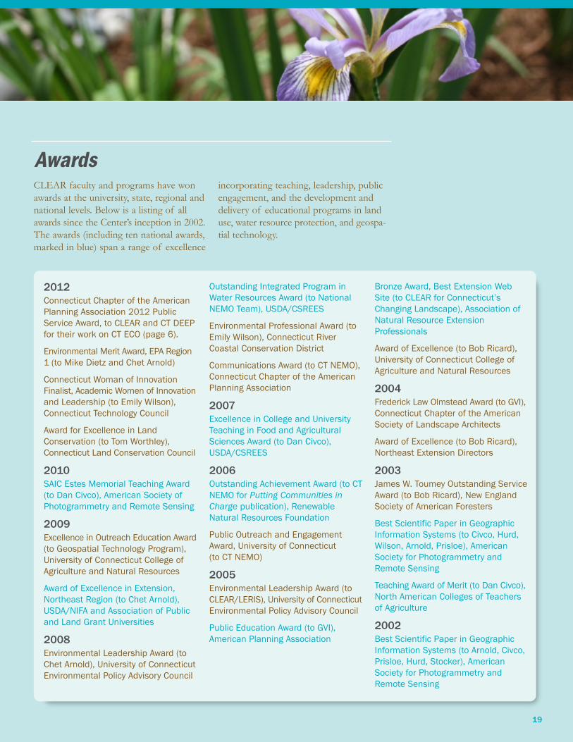
AwardsCLEAR faculty and programs have won
awards at the university, state, regional and
national levels. Below is a listing of all
awards since the Center’s inception in 2002.
The awards (including ten national awards,
marked in blue) span a range of excellence
incorporating teaching, leadership, public
engagement, and the development and
delivery of educational programs in land
use, water resource protection, and geospa-
tial technology.
2012
Connecticut Chapter of the American
Planning Association 2012 Public
Service Award, to CLEAR and CT DEEP
for their work on CT ECO (page 6).
Environmental Merit Award, EPA Region
1 (to Mike Dietz and Chet Arnold)
Connecticut Woman of Innovation
Finalist, Academic Women of Innovation
and Leadership (to Emily Wilson),
Connecticut Technology Council
Award for Excellence in Land
Conservation (to Tom Worthley),
Connecticut Land Conservation Council
2010
SAIC Estes Memorial Teaching Award
(to Dan Civco), American Society of
Photogrammetry and Remote Sensing
2009
Excellence in Outreach Education Award
(to Geospatial Technology Program),
University of Connecticut College of
Agriculture and Natural Resources
Award of Excellence in Extension,
Northeast Region (to Chet Arnold),
USDA/NIFA and Association of Public
and Land Grant Universities
2008
Environmental Leadership Award (to
Chet Arnold), University of Connecticut
Environmental Policy Advisory Council
Outstanding Integrated Program in
Water Resources Award (to National
NEMO Team), USDA/CSREES
Environmental Professional Award (to
Emily Wilson), Connecticut River
Coastal Conservation District
Communications Award (to CT NEMO),
Connecticut Chapter of the American
Planning Association
2007
Excellence in College and University
Teaching in Food and Agricultural
Sciences Award (to Dan Civco),
USDA/CSREES
2006
Outstanding Achievement Award (to CT
NEMO for Putting Communities in
Charge publication), Renewable
Natural Resources Foundation
Public Outreach and Engagement
Award, University of Connecticut
(to CT NEMO)
2005
Environmental Leadership Award (to
CLEAR/LERIS), University of Connecticut
Environmental Policy Advisory Council
Public Education Award (to GVI),
American Planning Association
Bronze Award, Best Extension Web
Site (to CLEAR for Connecticut’s
Changing Landscape), Association of
Natural Resource Extension
Professionals
Award of Excellence (to Bob Ricard),
University of Connecticut College of
Agriculture and Natural Resources
2004
Frederick Law Olmstead Award (to GVI),
Connecticut Chapter of the American
Society of Landscape Architects
Award of Excellence (to Bob Ricard),
Northeast Extension Directors
2003
James W. Toumey Outstanding Service
Award (to Bob Ricard), New England
Society of American Foresters
Best Scientific Paper in Geographic
Information Systems (to Civco, Hurd,
Wilson, Arnold, Prisloe), American
Society for Photogrammetry and
Remote Sensing
Teaching Award of Merit (to Dan Civco),
North American Colleges of Teachers
of Agriculture
2002
Best Scientific Paper in Geographic
Information Systems (to Arnold, Civco,
Prisloe, Hurd, Stocker), American
Society for Photogrammetry and
Remote Sensing

Contact CLEAR
20
Center for Land Use Education and Research (CLEAR)
University of Connecticut
Middlesex County Extension Center
1066 Saybrook Road, P.O. Box 70
Haddam, CT 06438
Phone: 860-345-4511
Email: [email protected]
CLEAR Contact Information
National NEMO NetworkDavid Dickson, National NEMO Network
Coordinator, Extension Educator
Phone: 860-345-5228
Email: [email protected]
Website: nemonet.uconn.eduGeospatial Technology (GTP)Cary Chadwick, Geospatial Training Program
Coordinator, Extension Educator
Phone: 860-345-5216
Email: [email protected]
Emily Wilson, Geospatial Specialist, Extension
Educator
Phone: 860-345-5226
Email: [email protected]
Website: clear.uconn.edu/geospatial
NEMO (Nonpoint Education
for Municipal Officials)Michael Dietz, CT NEMO Director, Extension
Educator
Phone: 860-345-5225
Email: [email protected]
Website: nemo.uconn.edu
Land Use AcademyBruce Hyde, Land Use Academy Coordinator,
Extension Educator
Phone: 860-345-5205
Email: [email protected]
Website: clear.uconn.edu/lua
Forestry (Forest Stewardship and Coverts)
Tom Worthley, Assistant Extension Professor
Phone: 860-345-5232
Email: [email protected]
(Urban and Community Forestry, Meskwaka
Project)
Robert Ricard, Senior Extension Educator
Phone: 860-570-9257
Email: [email protected]
Website: www.ctforestry.uconn.edu
CLEAR Program Contact Information
Mailing Address
Chet Arnold, Associate Director
Department of Extension
Phone: 860-345-5230
Email: [email protected]
Dan Civco, Director
Department of Natural Resources and
the Environment
Phone: 860-486-2840
Email: [email protected]

Connecticut Change MapThe Connecticut change map is a part of the Changing
Landscape Project (see Key Impacts, page 4) and shows
land use change between 1985 – 2010. In this example,
from central Connecticut, red depicts newly-developed land
since 1985 and yellow depicts new turf and grass, main-
tained grasses associated mostly with developed areas.
Details about this and other changing landscape projects
are at clear.uconn.edu/projects/landscape.

Center for Land Use Education and Research (CLEAR)
University of Connecticut
Middlesex County Extension Center
1066 Saybrook Road, P.O. Box 70
Haddam, CT 06438
Phone: (860) 345-4511
Email: [email protected]
Web: clear.uconn.edu
Connecticut
CLEAR is a partnership of the Department of Extension and the Department of Natural Resources and the Environment at the College
of Agriculture and Natural Resources, and the CT Sea Grant College Program. Support for CLEAR comes from the University of Connecticut
and from state and federal grants.
© 2013 University of Connecticut. The University of Connecticut supports all state and federal laws that promote equal opportunity and
prohibit discrimination. 130216.1


![AnalysisofOcularInjuryCharacteristicsinSurvivorsofthe8.12 ...downloads.hindawi.com/journals/joph/2019/1360805.pdfCenter terrorist attack in 2001 [9, 10], Madrid train bombings in 2004](https://static.fdocuments.net/doc/165x107/6063c8409de2071cc42e45ab/analysisofocularinjurycharacteristicsinsurvivorsofthe812-center-terrorist-attack.jpg)