The Transformation of Old Industrial District of Ankara and Political Actors
122
THE TRANSFORMATION OF OLD INDUSTRIAL DISTRICT OF ANKARA AND POLITICAL ACTORS A THESIS SUBMITTED TO THE GRADUATE SCHOOL OF NATURAL AND APPLIED SCIENCES OF MIDDLE EAST TECHNICAL UNIVERSITY BY MEHMET SANER IN PARTIAL FULFILLMENT OF THE REQUIREMENTS FOR THE DEGREE OF MASTER OF ARCHITECTURE IN ARCHITECTURE JUNE 2004
-
Upload
bilge-can-yildiz -
Category
Documents
-
view
99 -
download
0
Transcript of The Transformation of Old Industrial District of Ankara and Political Actors

THE TRANSFORMATION OF OLD INDUSTRIAL DISTRICT OF ANKARA
AND
POLITICAL ACTORS
A THESIS SUBMITTED TO
THE GRADUATE SCHOOL OF NATURAL AND APPLIED SCIENCES
OF
MIDDLE EAST TECHNICAL UNIVERSITY
BY
MEHMET SANER
IN PARTIAL FULFILLMENT OF THE REQUIREMENTS FOR THE DEGREE OF
MASTER OF ARCHITECTURE
IN
ARCHITECTURE
JUNE 2004

Approval of the Graduate School of Natural and Applied Sciences
_________________________
Prof. Dr. Canan Özgen
Director
I certify that this thesis satisfies all the requirements as a thesis for the degree of
Master of Architecture.
_________________________
Assoc. Prof. Dr. Selahattin Önür
Head of Department
This is to certify that we have read this thesis and that in our opinion it is fully
adequate, in scope and quality, as a thesis for the degree of Master of
Architecture.
___________________________ _________________________
Assoc. Prof. Dr. Güven Arif Sargın Assoc. Prof. Dr. Ali Cengizkan
Co-Supervisor Supervisor
Examining Committee Members
Assist. Prof. Dr. Cânâ Bilsel (METU, ARCH) _________________
Assoc. Prof. Dr. Ali Cengizkan (METU, ARCH) _________________
Assoc. Prof. Dr. Güven Arif Sargın (METU, ARCH) _________________
Prof. Dr. İlhan Tekeli (METU, CP) _________________
Assoc. Prof. Dr. Çağatay Keskinok (METU, CP) _________________
ii

I hereby declare that all information in this document has been obtained and presented in accordance with academic rules and ethical conduct. I also declare that, as required by these rules and conduct, I have fully cited and referenced all material and results that are not original to this work. Name, Last name: Mehmet Saner
Signature :
iii

ABSTRACT
THE TRANSFORMATION OF OLD INDUSTRIAL DISTRICT OF ANKARA
AND
POLITICAL ACTORS
Saner, Mehmet
M.Arch., Department of Architecture
Supervisor: Assoc. Prof. Dr. Ali Cengizkan
Co-Supervisor: Assoc. Prof. Dr. Güven Arif Sargın
June 2004, 108 pages
This thesis is a monographic study to examine the transformation of the old
industrial district of Ankara, which is yet incomplete. Investigating the significant
reasons for its incompleteness, the study will concentrate on the intrinsic
dynamics of this process, and particularly on such important contributions of its
political actors. The aims of the study are to figure out the roles of political actors
in urban transformations, and to evaluate the position of architectural production
within such processes. As a consequence of this evaluation, the possible
approaches for the similar forthcoming urban transformations will be questioned,
with special reference to the political framework and the position of architectural
production within the same framework.
iv

Maltepe developed as an industrial district since the end of the 19th Century, and
served with the same function during the Republican period, until the 1950s when
there were necessities and requirements for transformation. The transformation
of the district occurred as two distinct processes on industrial production and
industrial service areas. The industrial production area remained partially
transformed, as a result of resistance mechanisms generated by the unavoidable
practical difficulties. The transformation of the industrial service area remained
incomplete as a result of varying design decisions at different periods. In general,
the incompleteness of the transformation of the old industrial district was
reasoned by either the incapability of political actors, or by the confrontations
between them.
The architectural production in this transformation was defined by the political
actors, whose positions were characterized by such circumstances, within which
the transformation occurred. Since the circumstances are different in any case,
any urban transformation has different intrinsic dynamics and peculiarities in
itself. Therefore, rather than approaching the issue of transformation with general
policies, the strategies must be developed for each specific case. These
strategies would also include the political actors, and the architects who
participate in the formation of those political actors.
Keywords: Urban Transformation, Political Actor, Architectural Production,
Industrial District
v

ÖZ
ANKARA’NIN ESKİ SANAYİ BÖLGESİNİN DÖNÜŞÜMÜ
VE
POLİTİK AKTÖRLER
Saner, Mehmet
Yüksek Lisans, Mimarlık Bölümü, Bina Bilgisi
Tez Yöneticisi: Doç. Dr. Ali Cengizkan
Ortak Tez Yöneticisi: Doç. Dr. Güven Arif Sargın
Haziran 2004, 108 sayfa
Bu tez, Ankara’nın eski sanayi bölgesinin henüz tamamlanmamış olan
dönüşümünü inceleyen monografik bir çalışmadır. Çalışma,
“tamamlanmamışlığın” nedenlerini araştırırken sürecin içsel dinamikleri ve
özellikle de politik aktörlerin katkıları üzerinde yoğunlaşacaktır. Bu çalışmanın
amacı, politik aktörlerin kentsel dönüşümlerdeki rollerini ortaya koymak ve mimari
üretimin bu süreçlerdeki pozisyonunu değerlendirmektir. Bu değerlendirmenin
sonunda, gelecek benzer kentsel dönüşümler için olası yaklaşımlar, politik
çerçeveye ve mimari üretimin bu çerçevedeki pozisyonuna özel bir vurgu ile
sorgulanacaktır.
vi

Maltepe, 19. Yüzyılın sonundan itibaren bir sanayi bölgesi olarak gelişmiş,
Cumhuriyet döneminde, dönüşüm için gereklilik ve taleplerinin olduğu 1950lere
kadar aynı işlevle hizmet vermiştir. Bölgenin dönüşümü endüstriyel üretim ve
endüstriyel servis alanlarında iki ayrı süreç olarak gerçekleşmiştir. Endüstriyel
üretim alanı, ortadan kaldırılamayan pratik zorlukların ürettiği direnç
mekanizmaları nedeniyle kısmen dönüşebilmiştir. Endüstriyel servis alanının
dönüşümü ise, farklı zamanlarda alınan farklı tasarım kararları nedeniyle
tamamlanamamıştır. Genel olarak eski sanayi bölgesinin dönüşümünün
tamamlanamamasının nedenleri ya politik aktörlerin yetkin olamayışları, ya da
politik aktörler arasında meydana gelen karşıtlıklardır.
Mimari üretimin dönüşümdeki pozisyonları, kendi pozisyonları da dönüşümü
oluşturan koşullar tarafından tanımlanan politik aktörler tarafından tanımlanmıştır.
Koşullar her bir durum için farklı olduğu için, her bir kentsel dönüşümün farklı
içsel dinamikleri ve özgünlükleri vardır. Bu yüzden, kentsel dönüşümlere genel
politikalar ile yaklaşmak yerine, her bir durum için stratejiler geliştirilmelidir. Bu
stratejiler politik aktörleri ve aktör oluşumlarında yer alan mimarları da içermelidir.
Anahtar Kelimeler: Kentsel Dönüşüm, Politik Aktör, Mimari Üretim, Sanayi
Bölgesi
vii

To my parents, and my sister...
viii

ACKNOWLEDGEMENTS
I would like to express my gratitude to my supervisor Assoc. Prof. Dr. Ali
Cengizkan and co-supervisor Assoc. Prof. Dr. Güven Arif Sargın for their
guidance, and criticism throughout the study, but especially for their patience and
positive attitude when I was more involved with several other studies. I would
also like to thank my other committee members, Prof. Dr. İlhan Tekeli, Assoc.
Prof. Dr. Çağatay Keskinok, and Assist. Prof. Dr. Cânâ Bilsel for their comments
and suggestions.
Special thanks go to Assoc. Prof. Dr. Özcan Altaban for providing me with Ankara
Metropolitan Area Master Plan Bureau reports; to the members of the
Development Department of the Greater Municipality of Ankara, but especially to
Vedat Sancaktar, who provided valuable archive materials for my study; to the
Chamber of Architects, Ankara Section for allowing me to make my research
deeper in their archive; and to Semra and Özcan Uygur, for providing the
documents about their Concert Hall project.
I am always grateful to my parents, not only for their endless supports and
patience, but also for keeping me away from a deep pessimism. This thesis could
not have been completed without their confidence.
Finally, I would like to thank all my friends, who never stopped assisting my study
with their endless efforts, and also comforting me in my uneasy periods. Last but
not least, I would like to sincerely thank Yasemin, who has always been by my
side for the past one year with the charm she brought to my life.
ix

TABLE OF CONTENTS
ABSTRACT ......................................................................................................... iv
ÖZ ....................................................................................................................... vi
DEDICATION ...................................................................................................... viii
ACKNOWLEDGEMENTS.................................................................................... ix
TABLE OF CONTENTS ...................................................................................... x
LIST OF FIGURES.............................................................................................. xii
CHAPTERS
1. INTRODUCTION ........................................................................................... 1
2. DEVELOPMENT OF MALTEPE AS AN INDUSTRIAL DISTRICT................ 7
2.1. 1892-1924: Spontaneous Development around the Railways ............... 9
2.2. 1924-1930s: Development within the Lörcher Plans .............................. 13
2.2.1. Physical Development ................................................................. 14
2.2.2. Political Actors at the Development ............................................. 17
2.2.2.1. Local Administration......................................................... 18
2.2.2.2. Central Authority .............................................................. 19
2.2.2.2.1. Ministry of Exchange, Development, and Settlement. 19
2.2.2.2.2. Ministry of Public Works ............................................. 19
2.2.2.3. Ankara Directorate of Development ................................. 20
2.3. 1930s-1950s: Development within the Jansen Plan............................... 20
2.3.1. Physical Development ................................................................. 22
2.3.2. Political Actors at the Development ............................................. 27
x

3. THE TRANSFORMATION OF THE INDUSTRIAL DISTRICT....................... 29
3.1. Background of the Transformation ......................................................... 29
3.1.1. Urban / Environmental Factors: Necessities................................ 30
3.1.2. Political Factors: Preferences ...................................................... 34
3.1.3. 1957 Yücel-Uybadin Plan: Determining the Route of
Transformation ................................................................................ 36
3.2. Transformation of the Industrial Production Area ................................... 38
3.2.1. Physical Transformation .............................................................. 39
3.2.2. Political Actors at the Transformation .......................................... 48
3.2.2.1. Local Administration......................................................... 49
3.2.2.1.1. Directorate of Development........................................ 49
3.2.2.1.2. EGO ........................................................................... 51
3.2.2.2. Central Authority .............................................................. 53
3.2.2.2.1. Preservation Board..................................................... 53
3.2.2.3. Chamber of Architects...................................................... 54
3.3. Transformation of the Industrial Service Area ........................................ 55
3.3.1. Physical Transformation .............................................................. 55
3.3.2. Political Actors at the Transformation .......................................... 73
3.3.2.1. Local Administration......................................................... 73
3.3.2.2. Central Authority .............................................................. 75
3.3.2.2.1. Ankara Metropolitan Area Master Plan Bureau.......... 76
3.3.2.2.2. National Committee.................................................... 78
3.3.2.2.3. The Ministry of Public Works and Settlement............. 79
3.3.2.2.4. Preservation Board..................................................... 80
3.3.2.3. Chamber of Architects...................................................... 81
4. COMPARATIVE EVALUATION..................................................................... 84
4.1. Comparative Evaluation in the Political Context..................................... 84
4.2. Comparative Evaluation in the Urban and Architectural Context ........... 89
5. CONCLUSION............................................................................................... 92
BIBLIOGRAPHY.................................................................................................. 98
xi

LIST OF FIGURES
FIGURES
2.1 The location of the research area in the city (City Map of Ankara) .............. 8
2.2 Boundaries of the research area (City Map of Ankara)................................ 8
2.3 First train station of Ankara (Batur, 1994: 113) ............................................ 9
2.4 A map of Ankara dated to early 1920s (Şenyapılı, 1983) .......................... 11
2.5 A map of Ankara dated to late 1920s (Şenyapılı, 1983) ............................ 12
2.6 1924-25 Lörcher Plans (Cengizkan, 2003) ................................................ 14
2.7 The train station and surroundings at early 1930s (Ankara Posta
Kartları, 1994). ........................................................................................... 15
2.8 Focus on 1928 Jaussely Revision Plan (Dufournet, 1984: 81). ................. 16
2.9 The area of coal gas factory in Lörcher Plans (focus on fig. 2.6). .............. 17
2.10 A photograph of early 30s (Ankara Posta Kartları, 1994). ......................... 17
2.11 Jansen Plan (Archive, METU Faculty of Architecture). .............................. 21
2.12 Industrial district in Jansen Plan (Archive, METU Faculty of
Architecture)............................................................................................... 21
2.13 Industrial district in Jansen Plan. (Şenyapılı, 1983) ................................... 23
2.14 Cargo station at the east of the central station in Jansen Plan. ................. 24
2.15 The small-scaled factories at the south of the train station at early 40s
(Ankara Posta Kartları, 1994)..................................................................... 25
2.16 The parcels set in Jansen Plan (Şenyapılı, 1983)...................................... 25
3.1 1957 Yücel-Uybadin Plan (Archive, METU Faculty of Architecture) ......... 36
3.2 Main and secondary roads proposed in and around the industrial
district Yücel-Uybadin Plan (Archive, The Greater Municipality of
Ankara)....................................................................................................... 37
3.3 Industrial district in 1957 Yücel-Uybadin Plan (Archive, The Greater
Municipality of Ankara) ............................................................................... 38
xii

3.4 Industrial Production Area from city map of Ankara (City Map of
Ankara)....................................................................................................... 39
3.5 Aerial view of the production area (Archive, The Greater Municipality
of Ankara)................................................................................................... 39
3.6 Industrial production area in Yücel-Uybadin plan (focus on fig.3.3)........... 40
3.7 Production area in the implementation plan (1965) (Archive, The
Greater Municipality of Ankara).................................................................. 41
3.8 Detail on implementation plan (1965) (focus on fig. 3.7)............................ 42
3.9 The area of the coal gas factory (Archive, The Greater Municipality of
Ankara)....................................................................................................... 46
3.10 The coal gas factory................................................................................... 46
3.11 Flour and macaroni factories shown in a city map in early 90s.................. 47
3.12 The remaining structures of flour factory.................................................... 47
3.13 The lot of the new hypermarket (Archive, The Greater Municipality of
Ankara)....................................................................................................... 47
3.14 The new hypermarket. ............................................................................... 47
3.15 The area of Gazi University (Archive, The Greater Municipality of
Ankara)....................................................................................................... 48
3.16 Gazi University. .......................................................................................... 48
3.17 School (Old Yükseliş High School). ........................................................... 48
3.18 Industrial service area from city map of Ankara (City Map of Ankara). ...... 55
3.19 Aerial view of the service area (Archive, The Greater Municipality of
Ankara)....................................................................................................... 55
3.20 Industrial service area in Yücel-Uybadin plan (focus on fig.3.3) ................ 56
3.21 The structures present on the area at early 70s (AMANPB,
01.04.1971). ............................................................................................... 61
3.22 Schematic representation of proposed linear zone including the
service area (AMANPB, 01.04.1971). ........................................................ 62
3.23 The project area of the municipality including the service area
(Atabaş, 1994)............................................................................................ 64
3.24 Atatürk Cultural Center Areas (T.C. Law #2302, Değişik 3.Madde
23.04.1981)... ............................................................................................. 67
xiii

3.25 The future plan of the service area, obtained by overlapping project
plan (Uygur Mimarlık) and 1997 plan (Archive, The Greater
Municipality of Ankara). .............................................................................. 70
3.26 Maintenance ateliers of railways before restoration. .................................. 71
3.27 Ateliers after restoration, as a museum of contemporary arts.................... 72
3.28 Present situation of the service area. ......................................................... 72
3.29 Sports hall. ................................................................................................. 72
3.30 Current concert hall. ................................................................................... 72
3.31 Flowchart of transformation of industrial district ......................................... 83
xiv

CHAPTER 1
INTRODUCTION
The basic concerns of this study are the urban transformations and the position
of architectural production in urban transformation processes. This thesis will be
monographic study examining the transformation of old industrial district of
Ankara, which is yet incomplete. Investigating the significant reasons for its
incompleteness, the study will concentrate on the intrinsic dynamics of the
process, and particularly on such important contributions of political actors. The
aims of the study are to figure out the roles of political actors in urban
transformations, and to evaluate the position of architectural production within
such processes. As a consequence of this evaluation, the possible approaches
for the similar forthcoming urban transformations will be questioned, with special
reference to the political framework and the position of architectural production
within the same framework.
In general sense, a transformation means a structural change; and an urban
transformation means a structural change in spatial, functional, or social
formation of urban areas. A renovation, regeneration, rehabilitation, revitalization,
re-functioning, re-definition, or gentrification, any urban transformation comprises
a structural change (Tekeli, 2003: 5). In most urban transformations the changes
in spatial situation or function take place together with the one in social structure;
or one generates the other. A spatial change may trigger a social change or a
social change may result with a change in the urban form. Both sides of urban
transformations, spatial and social, are complementary to each other.
Cities are almost always the subjects of on-going or impending transformations.
Although each urban transformation reveals divergences from another, they
actually perform a cumulative change in the whole city; thus, they should be
1

considered as the components of a total transformation. A transformation may be
originated by a population increase, by a change in the economic life of the city,
by growth of the city, by re-organization of the social strata, or even by the
requirement for new viable buildings instead of the older ones (Tekeli, 2003: 3-4).
But none of these constitutes an urban transformation only by itself; they are all
interrelated with each other. This interrelation is reasoned on the wholeness of
the city (Tekeli, 2003: 3-4). It means that no particular transformation occurs
exclusively in itself, nor it is isolated; but any structural change in any part of the
city stimulates a total transformation within the whole city.
Therefore, an analysis of the transformation of a limited area requires finding out
the correlations with the transformations at the rest of the city.
On the other hand there emerge resistance mechanisms to transformations
within the city. These mechanisms may be generated by economical factors,
symbolic values, property relations, or by some restrictions imposed by plan
decisions. For instance, if transforming a technically enduring building or
transforming an area including such buildings is not economical when compared
with the profit to be gained from this operation, then the economical factors
generate a resistance mechanism to the transformation. Or if a building or an
area has an urban, architectural, aesthetic, environmental, or historical value,
then this symbolic value generates the resistance mechanism to the
transformation, which would consist of demolishing and re-building. Shared
ownerships of a building or of an urban land may also generate a resistance
mechanism to the transformation, which requires the approval of each of the
property owners. Or some development regulations or preservation decisions
may prevent a transformation by generating resistance mechanisms. (Tekeli,
2003: 4-5)
When considered together, impending urban transformations are usually met with
a resistance mechanism. If the pressure beyond, either will or necessity for
transformation is stronger than resistance factors, then the transformation occurs.
On the other hand, if the resistance factors are stronger, the transformation either
does not occur or sustains until the resistances diminish. Spontaneous urban
2

transformations occur within one of these two probable frameworks. Yet, if it is a
designed or planned transformation, a third alternative may happen. When the
transformation pressure and resistance factors meet, or even when the
transformation requirements come into existence, an authority may decide
whether or not the transformation should be exercised. Nevertheless, the
authority may not be powerful enough to decide, but may take its position for
either supporting the transformation or the resistance mechanism. If the authority
supports the transformation, the process accelerates; and if the authority
strengthens the resistance mechanism, the transformation either does not occur,
or sustains until another authority supports the transformation. In the second
case, when both a transformation is supported and its resistance mechanism is
strengthened by different authorities, there occurs a confrontation between the
authorities. Then the transformation becomes an authority problem; and since it
is an urban transformation, it appears as an authority problem on the urban
realm.
The questions to be asked here are those: which authority, why, and how is
joined to the process? The answers are related with the characteristic of urban
transformation to be a public matter. Since an urban transformation takes place
on the public realm, the right to decide on the process belongs to the public; the
only authority is the public. However, in the political organization, the public
charges political institutions for their own governance, and these institutions act
as intermediary organizations in public authorization cases. In the case of an
urban transformation, these political institutions decide on the transformation to
occur, or not, in the name of public. If it is decided to occur, then how to realize
the transformation must also be decided. At that stage, the institutions transmit
the authority given them by the public to the designer, either architect or planner.
Such an intermediary action makes the institution join the urban transformation
process. As a result of its political character, the urban transformation becomes a
political process, where the institution and the designer act together as a political
actor. The designer does not have to be a political actor by himself, but may be a
technocrat who is responsible from developing plans. Even then the political
organization he is serving for makes him join the political urban transformation
process as a component of a political actor. Thus, the term “actor” should better
3

be used in general sense for the subjects of the transformation, either at decision,
or design level. The actor refers to any person, and to any institutional subject as
well, who contributed to the transformation process positively or negatively, at
design or implementation stages, or at controlling position.
Therefore, an analysis of an urban transformation requires figuring out the whole
influences of political actors on the process, which is in fact the first aim of this
study.1
On the other hand, political actors are not able to determine their positions within
a transformation process by themselves. The positions for political actors are
rather determined by the circumstances, within which the transformation
emerges. The actor occupies a definite position within these circumstances.
This is a post-structuralist and particularly Foucauldian point of view to consider
subjects not a priori given, but as the figures formed by the society, or by social
conditions (Game, 1998: 65). In his “The Archaeology of Knowledge”
(L’Archéologie du savoir), Foucault mentions on the “subject positions”, when
explaining the components of discursive formations: “The positions of the subject
are also defined by the situation that it is possible for him to occupy in relation to
the various domains or groups of objects” (Foucault, 2002: 57-58). What
important here is not the subject himself as an individual, but the position he
occupies. In the same conception, an investigation on subjects means an
investigation on the subject positions, and consequently on the discourse that set
up these positions. The media of this investigation are the “statements” of the
subjects. These statements are expected to reveal not only the subjects, but also
the conditions which produce them, or which made the subjects speak them.
(Foucault, 2002; Keskin, 1999)
This framework enables a methodology for examining the case study of this
thesis. As this study will be carried on by investigating the political actors, who
were the subjects of an urban transformation, it also appears as an investigation
on the subject positions within an urban transformation. Thus, to dwell on the
4
1 This argument is valid if only it is not a spontaneous urban transformation. Spontaneous urban transformations are not taken into consideration in this study.

statements of the political actors will not only reveal the political actors
themselves, but also demonstrate the circumstances within which the
transformation occurred. Additionally, it will make the evaluation of position of
architectural production within urban transformations possible, which is the
second aim of the study.
From the architectural point of view, there assumed to be two possible positions
for architectural production in politically shaped urban transformation processes.
First, if the architect is not involved in the process as a political actor, or if the
architect does not act together with an institution to constitute a political actor, it
means that the circumstances do not set a position for architectural production
within the transformation. In that situation the ways, possibilities, and limits of
architectural production remain to be determined by the limitations of another
designer and/or actor within the process. Second, if the architect participates in
the process as a political actor, or at least as a component of a political actor, it
means that there is a suitable position for architectural production set by the
circumstances. In that situation, the ways, possibilities, and limits of architectural
production may be determined by a political actor, including the architect.
In this study, the incomplete transformation of the old industrial district of Ankara
will be examined, and this examination is assumed to reveal both of the possible
positions for architectural production in politically shaped urban transformations.
The old industrial district of Ankara was Maltepe and its close environment. In the
second chapter the development of the industrial district will be examined in three
subsequent periods. First one is the spontaneous development period between
1892 and 1924, from the arrival of railways at the city in 1892, until the first
planning attempt in 1924. The second one is the first planned development
period of the area according to the Lörcher Plans, between 1924 and 1930s. And
the third one is between 1930s and 1950s, when the development of the district
was directed according to Jansen Plan.
In the third chapter the transformation of the old industrial district will be
examined comprehensively in three sections. In the first section, the background
5

of the transformation will be explained with necessities and preferences beyond;
with special reference to Yücel-Uybadin Plan as comprising the first decisions on
the transformation of the district. Since the transformation occurred on two
distinct areas as two distinct processes, the transformations of each industrial
production and industrial service areas will be examined in the following two
sections. Besides the physical transformation, the effects of the political actors
will take place in these sections.
The fourth chapter will be consisted of two comparisons. The two-sided
characteristic of the transformation of the old industrial district will enable a
comparative evaluation on two realms. First one will be an evaluation in the
political context, and the second one will be in the urban-architectural context.
In the conclusion chapter, the outcomes of the comparisons will be employed in
questioning the possible approaches for the similar forthcoming urban
transformations, with special references to the political framework and the
position of architectural production within the same framework; which is actually
the last aim of the study.
6

CHAPTER 2
DEVELOPMENT OF MALTEPE AS AN INDUSTRIAL DISTRICT
Ankara had never been a city of industry, but there has always been an industrial
production in the city since the ends of 19th century.2 The amount of industrial
production and the scale of industrial areas in Ankara have been limited enough
to satisfy the basic needs of the city population. Thus, not the improvement of
industry made the city develop, but the development of the city has made the
industry improve in Ankara.
Although there had been a number of industrial establishments in Ankara before
the Republican period, they were far away from forming up an industrial district,
as they were dispersed in and around. The first dense location of industry was in
1920s, in the form of an axis lying along the railway lines next to the station.
There were İmalat-ı Harbiye ateliers (weaponry factories) at the west, and some
other factories, ateliers, and storing units at the east of the station. The density of
industrial establishments at the eastern portion of that axis had increased more
than any other part of the city in early Republican period, so that Maltepe and its
close neighborhood turned out to be the first industrial district of Ankara.3
The research area for this study is surrounded by Talatpaşa Boulevard at north,
Gazi Mustafa Kemal Boulevard and Toros Street at south, Atatürk Boulevard at
east, and main railways station at west.4 (fig. 2.1, 2.2)
2 Most of the scholars dwelling on the industrial developments in Ankara consider the local traditional production as a sub-title of industrial production. However, the term, industry, refers to machinery-aided production in this study. 3 For this study, the term “industrial district” refers solely to the industrial areas at the east of the central railways station.
7
4 For the names of boulevards, roads, and districts, which have changed in time, the present names are preferred in order to prevent any possible confusion.

Fig. 2.1. Research area in the city
Fig. 2.2. Boundaries of the research area
8

The development of the area will be examined in three subsequent periods:5
• 1892-1924: Spontaneous Development Around the Railways
• 1924-1930s: Development within the Lörcher Plans
• 1930s-1950s: Development within the Jansen Plan
2.1. 1892-1924: Spontaneous Development Around the Railways
The initial factors determining the development of area as an industrial district
were the railway lines and the central railway station. Therefore, the beginning of
development should be dated to November 1892, when the railway connection of
Ankara was provided as a leg of railways project between Istanbul and Baghdad
(Ortaylı, 1994: 112).6
Fig. 2.3. The first train station of Ankara
The foremost effect of railways had been the vitality it brought to the economic
life of the city (Tekeli, 1994a: 176). The railway connection provoked the
emergence of new agricultural areas, and consequently the increase in the
agricultural production at regional scale (Yavuz, 2000: 201-202). Though Ankara 5 Although these periods seem consistent with the generally accepted planning periods of Ankara, the study will pay attention to genuine development periods of the district itself, which may or may not present such a consistency with the superior planning historiography of the city.
9
6 For more information on Baghdad railways project see Özyüksel, 2000; Rathmann, 2001; and for its effects on Ankara see Ortaylı, 2000; and Yavuz, 2000.

could not go beyond performing as a collecting station for these agricultural
products (Ortaylı, 2000: 208), the increase in the production, taxes, and
exportation was followed by an increase in the surplus of the city at that period
(Yavuz, 2000: 202). The increasing surplus controlled in the city provided the
variation of urban services and activities; and railways and station appeared as
new determinants in the site selection of those urban services (Tekeli, 1994a:
176). In other words, railway connection triggered a series of developments not
only in the economy of Ankara, but also on the urban form. The area around the
railway lines and the station was the center of this development. The new
formation of the area may be examined in three categories according to the
functions of the new structures it welcomed:
(a) Storing units:
Performing as a collecting station, there must have emerged a
requirement for storing units in the city, so that the number of large stores
increased from 50 to 260 in Ankara between 1895 and 1902 (Aktüre,
1978: 128, table 3). Large stores and entrepôts (bonded warehouses)
were located along the railway lines, in close proximity to the station, and
especially at the east side for the trade and transportation of stored
products and goods, (fig. 2.4). For this study, there are two significant
outcomes of locating the storing units at this place:
• The road connecting the station to the old city center, Yukarı Yüz
was serving as a trade axis facilitating the transportation of goods
within the city between the storing units and the old trade center.
So, besides feeding the area with structures of storage, the same
road also set up a boundary for the expansion of the area. It is
apparent that the road, which was the preliminary form of today’s
Talatpaşa Boulevard, has marked the north boundary of the first
industrial district since the end of 19th century. (fig. 2.2, 2.4)
• The upcoming function of the area has been determined by the
dense location of large stores, and entrepôts. As will be explained
in the following chapters, that portion of the industrial district had
continuously served for storage and trade facilities up to 1970s.
10

Fig. 2.4 A map of Ankara dated to early 1920s, showing the roads connecting the station to old and new city centers and large stores along the railway lines, in close proximity to the station.
(b) Small-scale industrial structures:
Railways and station were new determinants in the site selection of new
small-scale industrial structures at the neighborhood. For instance, a flour
factory was established as a new urban service at the end of 1890s
(Aktüre, 1978: 128, table 3). As it was running on steam power (Yavuz,
2000: 197), it must have been placed close to the railway lines. The
second flour factory, again with steam power, was established near the
station in 1906 (Tekeli, 1994a: 176).
However, it would be misleading to consider all industrial developments
as conditioned by railways; because, railways primarily served for
transportation and trade facilities at that period, rather than providing the
technical equipment for industrial production.
11

(c) Maintenance ateliers of railways:
When the railway connection was provided, the maintenance ateliers of
railways were also set with two lathe-workbenches (Tekeli, 1994a: 176).
They must have been located at the east side of the area together with
the hangars, where they developed into Şimendifer Fabrikası (railways
factory) at the end of 20s (fig. 2.5). The equipment of the maintenance
ateliers was allocated for the weaponry factories during the War of
Independence, when İmalat-ı Harbiye was founded at the west side of the
station (Kemal, 1983: 29-30).
Fig. 2.5 Şimendifer Fabrikası is right at the east of the station.
The development of the first industrial district of Ankara was originated with these
spontaneous formations of the site. It was not a premeditated development, and
no actor had contributed to the process. The spontaneous development was
paused during the First World War, until the designation of Ankara as the
headquarters of the War of Independence and subsequently as the capital city.
12

Ankara was declared as the capital city and Republic of Turkey was founded
consecutively in 1923. This year is considered as a breaking not only in the
Turkish history, but also in the history of Ankara. Nevertheless, the spontaneous
development of the area had not ended until the foundation of Şehremaneti of
Ankara and until the preparation of Lörcher Plan in 1924. Therefore, the planned
development should be investigated starting from 1924.
2.2. 1924-1930s: Development within the Lörcher Plans
Having the War of Independence just finished, the primary concerns of the new
Republic of Turkey were the safety of the country, building up an independent
economy, the resettlement problem of migrants, and satisfying the basic needs of
the population (Cengizkan, 2002a: 37). Besides the common ones, Ankara had
some other peculiar problems. When the city was declared as the capital, the
increase in the population was followed by an increase in the demand for
housing, and for the infrastructural services as well. In a report of Mübadele, İmar
ve İskan Vekaleti (Ministry of Population Exchange, Development, and
Settlement) dated to 1924, these required services were declared as sewer
system, clean water supply, illumination of streets, street construction, in-city
transportation, and telephone system (Cengizkan, 2002a: 39-40). According to
the same report, The Municipality of Ankara had to be settled and a city plan had
to be produced rapidly for the intended solutions of those problems (Cengizkan,
2002a: 39-40).7 Lörcher Plans were devised to serve for this immediate function.
They consisted of two complementary plans for old city and Yenişehir (the new
city), dated to 1924 and 25 respectively (Cengizkan, 2002a: 45) (fig. 2.6). These
plans also comprised the first footsteps of a planned development process for the
industrial district.
13
7 There had already been a Map of Ankara Şehremaneti, prepared by military experts in 1924, demonstrating the present situation. It must have provided a base for Lörcher’s plan for the old city (Cengizkan, 2002a: 41)

Fig. 2.6. 1924-25 Lörcher Plans. Highlighted area was reserved for industries. 2.2.1. Physical Development
Lörcher had taken the railway lines as a boundary between the old city and
Yenişehir (Vardar, 1989: 42). Therefore, the area along the railway lines took
place in both of his plans. In 1924 plan for the old city, a plain land of 3 km long
and 400 m wide was reserved for the future development area, for the station, for
the connections to industries, and for the new industrial establishments (Vardar,
1989: 39) (fig. 2.6). In 1925 plan, a green belt, afforested on two sides, was kept
along the railway lines in order not to prevent the possible development of
railways and in order to detach the industrial area from the new housing district
(Vardar, 1989: 42). Lörcher’s attitude to isolate the industrial development area
can also be observed in his proposal for the new station in 1925 plan. He
proposed a second passenger station at the east, where there is Sıhhiye Bridge
today, while leaving the old one as a cargo station (Vardar, 1989: 42). Yet, this
proposal remained unrealized.
14

Fig. 2.7. The train station and surroundings at early 1930s
The number and scale of industries at the subject area did not increase rapidly at
this period. There were small-scale carpentry, timber, and other woodwork
factories, located nearby the station (Tekeli, 1994a: 178). However, those distinct
enterprises were far away from labeling the area as an industrial district. Although
the area had been reserved for industrial development in Lörcher plans, it was
not possible to define Maltepe as an industrial district, until the establishment of
electricity and coal gas factories in the area at the end of 20s.
The revision plan of Léon Jaussely proves the fragmentary development of the
district until 1928 (fig. 2.8). Jaussely was one of the three competitors invited to
attend the Ankara plan competition (Tankut, 1993: 66-67).8 It is understood from
the visual expression utilized in that plan that there were no irreversible
applications at Maltepe, in terms of industrial development until 1928.
15
8 His competition proposal was dated to 1925 in the periodical it was published (Dufournet, 1984: 81). However, it is known that he visited Ankara in July 1927, and prepared his proposal until December 1928 (Tankut, 1993: 67). So, the right dating must be to 1928.

Fig. 2.8. Focus on 1928 Jaussely Revision Plan. The present irreversible applications of Lörcher plan were marked with black counters, where new proposals took place in red. The lack of black countered proposals in the research area proves that there were no irreversible applications until 1928.
Maltepe Electricity Factory started to operate in 1929 (Tekeli, 1994a: 179). In the
same year the coal gas factory was founded in Maltepe; and the next year, in
1930, an oxygen factory was established as integrated to the coal gas factory
(Tekeli, 1994a: 179). The emergence of these railways-aided large-scaled
factories should be considered as a threshold, where the fragmentary
development of the area was replaced with a comprehensive development
process. Even though Jansen plan had been valid for Ankara since 1929, they
were the Lörcher plans employed in site selection of coal gas factory and in its
water pipe installations (Cengizkan, 2002a: 45) (fig. 2.9). This means that the
development of the district was still performed on Lörcher’s decisions at early
30s.
16

Fig. 2.9. The area of coal gas factory (highlighted) was determined in Lörcher Plans
Fig. 2. 10 A photograph of early
1930s
The emergence of a cluster of factories at Maltepe was also depending on those
decisions. A cold air and ice factory, a subsidiary beer factory of Bomonti, and a
flour factory were among the new establishments in this cluster (Tekeli, 1994a:
179). These were all industries that served for the requirements of the growing
city rather than being for industrial production per se. it is also essential here to
note that the location of the electricity factory was an important determinant in the
site-selection decisions for the industries; because there was a central electricity
network at that period, and it was advantageous for the industries to be in close
proximity to that single power plant.
2.2.2. Political Actors at the Development The political actors contributed to the development of Ankara, and consequently
of the industrial district were Şehremaneti, central authority, and Ankara İmar
Müdürlüğü (Ankara Directorate of Development) in this period.
17

2.2.2.1. Local Administration
After the declaration of the city as the new capital, a local practicing institution
had been required in order to solve the urgent problems of the city. Ankara
Şehremaneti was active between February 1924 and 1930. Organized under the
guardianship of Dahiliye Vekaleti (Ministry of Internal Affairs), the Şehremini
(mayor) and directors were appointed by the central authority (Tankut, 1993: 49).
It was responsible from solving the infrastructural problems of the city in general,
with the supports and custody of the government. Thus, Şehremaneti was
practicing as an extension of central authority, not merely as an autonomous
local administration.
The first Şehremini of Ankara was Mehmet Ali Bey (Cengizkan, 2002a: 43). He
took place in obtaining Lörcher Plans, but was relieved of his duty because of a
confrontation with Nafıa Vekaleti (Ministry of Public Works), and for the reason
that he could not work efficiently enough (Cengizkan, 2002a: 43). The second
Şehremini was Haydar Bey (Cengizkan, 2002a: 43). He presented a pragmatic
and efficient program so that he could immediately establish the required
construction industries (Tekeli, 1980: 54). The small-scaled factories at Maltepe
must have founded in this period. They were not only the investments of
Şehremaneti, but also of private enterprises, such as the carpentry and
woodwork factories, supported by the mayor at Maltepe (Tekeli, 1994a: 178).
Despite the high expenditure, the investments of Haydar Bey may be considered
as the successes of Şehremaneti (Tankut, 1993: 50). Yet, they were still
insufficient to label the area as an industrial district. Şehremaneti had already
been in debt, and was not capable of implementing large-scaled and costly
projects. The change in the characteristic of the district was designated by the
attempt of central authority.
Şehremaneti was converted into the Municipality of Ankara in 1930 (Tankut,
1993: 97).
18

2.2.2.2. Central Authority
The central authority contributed to the development of the industrial district in
this period through the Mübadele, İmar ve İskan Vekaleti (Ministry of Public
Exchange, Development, and Settlement and through the Ministry of Public
Works.
2.2.2.2.1. Ministry of Population Exchange, Development, and Settlement
Although it was decided to establish Ankara Şehremaneti on 17th October 1923
(Cengizkan, 2002a: 38), it could not be concluded until 16th February 1924
(Tankut, 1993: 49). In this gap of four months, Ministry of Exchange,
Development and Settlement which had already been occupied with the resettling
problems of immigrants, took on the responsibility to solve the urgent problems of
Ankara (Cengizkan, 2002a: 39). In 1924, the same ministry prepared the report
mentioned above, declaring the required services for the city. Preparing the
grounds for forthcoming Lörcher plans, the ministry had contributed to the
development of the area as an actor until the establishment of Şehremaneti.
2.2.2.2.2. Ministry of Public Works
Since Şehremaneti had not been capable of implementing large-scale and costly
projects, The Ministry of Public Works supervised the consortium of German
Didier Company for production of coal gas and electricity in April 1928
(Cengizkan, 2002a: 42). In the same year Ankara Company of Coal Gas and
Electricity was founded with high rated foreign capital of that consortium
(Cengizkan, 2002a: 43). Only after these attempts, the large scale factories could
be established, and the area could turn into an industrial district. It may well be
regarded as the appearance of central authority on the scene as the dominant
political actor on other institutions and individuals.
19

2.2.2.3. Ankara Directorate of Improvement
The shift of the political actors, from local administration to central authority was
not limited with the infrastructural service supplies. After the urgent problems of
the city had dissolved, Ankara started to be considered as the scene and model
of the Turkish modernization, which would require a new and comprehensive
development plan. For the reason that the technical staff and the legal position of
Şehremaneti would not be sufficient, Ankara İmar Müdürlüğü (Ankara Directorate
of Development) was founded on 28th May 1928 for implementing the
forthcoming development plan (Tankut, 1993: 72). Directorate was defined as an
extension of Ministry of Internal Affairs, and the deciding unit of the Directorate
was İmar İdare Heyeti (Management Board of Development), whose members
were selected in the Cabinet (Tankut, 1993: 94). The establishment of the
Directorate of Development meant that Şehremaneti, and subsequently the
municipality was excluded from the development of Ankara.9 The attitude of the
central authority was revealed in the statement: “the development of the capital
city of The Republic of Turkey is directly the matter of the government, not that of
a municipality”10 (Tankut, 1993: 72). This statement also illustrated that the
directorate was not a local administration organ, but a practicing extension of the
central authority. Nevertheless, the directorate was associated with the
Municipality of Ankara in 1937 and became a unit within the local administration
since then (Tankut, 1993: 73).
2.3. 1930s-1950s: Development within the Jansen Plan
The second comprehensive development plan for Ankara was obtained via an
invited competition, where three international architects were invited to attend
(Tankut, 1993: 66). Among them Hermann Jansen won the competition, and his
proposal was implemented as an avant-projet between 1929 and 1932 (Tankut,
1993: 91). Jansen’s complete plan was approved in 1932 and implemented
9 Only a member of municipality could participate in İmar İdare Heyeti, so that municipality could take place in the development of the at representation level.
20
10 “Cumhuriyetin Başkentinin imarı bir şehir Belediyesinin meselesi değil, doğrudan doğruya bir devlet meselesidir.” (Translation mine.)

extensively between 1932 and 39 (Tankut, 1993: 127) (fig.2.11). Although Jansen
had been released of his duty in 1939, the development of Ankara continued until
1950s according to the general framework of this plan. The development of the
first industrial district was also sustained with this plan up to 50s. (fig. 2.12)
Fig. 2.11. Jansen Plan
Fig. 2.12. Industrial district in Jansen Plan
21

2.3.1. Physical Development
A requirement list had already been prepared by Şehremaneti in 1927, which
would in turn constitute the basis for the competition specifications (Tankut, 1993:
63). It was stated in the 14th clause of that list, “the area between Ankara Sivas
[railway lines] and Ankara station is allotted for industry and factories” (T.C.
Ankara Şehremaneti, 1929: 5).11 Jansen did not propose a new location for
industry and left the mentioned area to industrial development (fig. 2.12, 2.13).
That place had already been the first extension area of industries in Ankara; and
furthermore, Lörcher had already reserved the same place for the development of
industry. It is evident that neither Şehremaneti, nor Jansen offered any location
for industry, different than what had already grown spontaneously, and what
Lörcher had made definite afterwards.
On the other hand Jansen’s decisions were noteworthy for comprehending the
future development of the area. He explained his decisions on industry, railways,
and stations within an integrated growth scheme as follows:
Ankara can and will never be a city of industry. New experiences necessitate that industry must be settled, as much as possible, in surrounding areas, even in the places where there are ores, coal mines, and so on. It would be harmful for the city to expand in the linear area at the west of railways and south of the cargo station. [That area] is allocated to industry (for electricity, coal gas, etc.). For the location it is necessary to consider north and east winds.12
(Jansen, 1937: 20-21)
11 “Ankara Sivas ve Ankara istasyonları arasındaki arazının sanai ve fabrikalara tahsisi.” (Translation mine. Explanations in bold brackets mine.)
22
12 Sanayi Kısmı: Ankara kat’iyyen bir sanayi şehri olamaz ve olmıyacaktır. Yeni tecrübeler sanayiin mümkün olduğu kadar civara, hatta maden, kömür ve saire olan yerlere kurulmasını icap ettiriyor. Demiryolunun garbinde eşya istasyonunun cenubunda şerit halinde bir kısım şehir için yayılması zararlı olur. Sanayie tahsis edilmişdir. (Elektirik; Havagazı ve saire için). Yer için şimali şarki rüzgarlarını nazarı itibara almak çok lazımdır. (Translation mine. Explanations in bold brackets mine.)

Fig. 2.13. Industrial District was shown as “Sanayi Sahası” in Jansen Plan
In his description Jansen indicated that the industry should be located at the west
of the railways, and at the south of the cargo station. He separated the cargo
station from that of passengers, as Lörcher had attempted to do. Similar to
Lörcher’s proposal, Jansen argued that the main passenger station had better be
located at the center of the city, where there is Sıhhiye Bridge today (Jansen,
1937: 22). Nevertheless he had to cease from this idea as a result of the high
level difference between the station and Atatürk Boulevard, which would create
many problems at the implementation stage (Jansen, 1937: 22). On the other
hand he insisted on designing two stations: one as a main passenger station, the
other as a cargo station. He explained the cargo station proposal and designing
the northeast part of the industrial area with transportation facilities as such:
The cargo station lies between the main station and Atatürk Boulevard, where a transportation street reaches at the station, as parallel to the boulevard. It is connected to close industry centers with separate lines. It is thought to construct a marketplace at the north edge of the station street. This place is very suitable for transportation.13
(Jansen, 1937: 23)
23
13 Eşya Yük İstasyonu: Büyük istasyon ile Atatürk bulvarı arasında yük istasyonu uzanarak, ayrıca bir nakliyat caddesi bulvara muvazı olarak istasyona varır. Buradan yakın senayi merkezlerine ayrı hatlarla birleşir. Istasyon caddesinin şimal kenarında bir hal yapılması düşünülmüşdür. Burası nakliyata oldukça müsaittir. (Translation mine. Explanations in bold brackets mine.)

Fig. 2.14. “Yük istasyonu” (cargo station) was proposed to be at the east of the central station in Jansen Plan
In short, Jansen allocated the area around the station for industry for two
reasons: the direction of dominant winds and easy connection for transportation
facilities (Tankut, 1993: 79). It is known that the transportation facilities have
taken place in the same location since 1890s, and industrial establishments have
already suggested to be settled in the same place by Lörcher. Therefore it would
be a mistake to consider Jansen’s decisions as the primary decisions on the
development of the industrial district. They had better be considered as an
important step in the process, which not only legitimated the current formation of
the area, but also made the future development persistent. Moreover, it is evident
that Lörcher’s plan decisions were still valid for the development of the district
even in 1930s. Therefore, Jansen’s decisions had better be regarded as
improving those of Lörcher for implementation.
24

Fig. 2.15. The small-scaled factories at the south of the train station at early 40s
The plan decisions on the industrial district were much more elucidated at the
implementation stage. A possible fragmentary development, like the one
happened at the implementation of Lörcher plans, was prevented by a number of
regulations. According to a decision, dated to 18.3.1938, the entire city was
divided into five regions and the industrial district was considered within the fifth
region (T. C. Ankara İmar Müdürlüğü, 1946: 121-123).14 In the same decision the
minimum parcel dimensions were also set so that the parcels would be suitable
for large-scale industrial structures (T. C. Ankara İmar Müdürlüğü, 1946: 126).
Fig. 2.16. The parcels were set in Jansen plan
25
14 The fifth region covered the whole industrial areas, not only the industrial district at the east, but also the lands at the west of the station.

In that period the heterogeneity in the functional allocation of industrial structures
had also become persistent. Since the end of 19th century, service structures,
such as stores, entrepôts, freight depots, hangars, and ateliers, were located at
the north of the railway lines, where production structures were settled at the
south. This tendency continued increasingly between 1924 and 1932, when the
development was carried on due to Lörcher plans. Finally after the approval of
Jansen plan in 1932, the division of the district into two, as “industrial service
area” and “industrial production area” became more apparent. The physical
growth of the whole site retained this situation more than the plan decisions did.
Railway lines were extending to south mainly for industrial production facilities.
They were serving for the electricity and coal gas factories by means of the
transportation of charcoal. At north, the services of railway lines were of two
kinds. They were extending either for the transport of raw material and other
goods, or for the maintenance ateliers and hangars. It is important to note that
the number of stores and warehouses increased at that period, again at the north
of railway lines. One of them was the Ankara Grains Silo, which was constructed
by German Miag Company between 1933 and 1937 (Cengizkan, 1994: 87)
Additionally, the wholesaling marketplace of the city was located at the northern
portion of the area in 1942 (Akgün, 1996: 192).15 Jansen plan irreversibly froze
this two-sided characteristic of the district. Besides, the two-sided character of the
forthcoming transformation was also marked with that step. The situation
observed in 1940s has taken place in a guidebook as follows:
The Station Neighborhood: It is on the plain area between Akköprü and Maltepe. Rather than being a residential district, this place presents a special characteristic for trade, with the large and modern station, Ministry of Communications, General Directorate of Devlet Demiryolları, Devlet Demiryolları School of profession, a wheat silo belonging to Toprak Mahsulleri Ofisi, warehouses for wood and charcoal, the marketplace of greengrocery and fruits, and station stores located here.
A small residential quarter is also being constructed by Devlet Demiryolları for its own employees.
26
15 This marketplace did not take place in Jansen plan, but constructed in 1942, just after Jansen had been released of his duty. The construction of this marketplace may well be regarded as a violation of Jansen plan.

Between this neighborhood and Maltepe There is the industrial district, which today includes some industrial establishments and a large area for the ones to be constructed at the future.16
(Türkiye Kılavuzu: 191)
What is remarkable at this quotation is that the author considers the two areas of
the industrial district as two adjacent neighborhoods. This means that the
differentiation between the industrial production and industrial service area were
observable to the extent that they could be perceived as separate areas in 1940s.
2.3.2. Political Actors at the Development
Tankut highlights three political actors who contributed to the application of
Jansen plan on the entire city between 1932 and 1939: the central authority, İmar
İdare Heyeti, and Municipality of Ankara (Tankut, 1993: 127-136). The
contributions of central authority were through debates between the deputies of
both government and opposition parties, in terms of economical conditions and
qualification of political organizations (Tankut, 1993: 128-133). İmar İdare Heyeti
and The Municipality of Ankara had taken place separately until 1937, when they
were combined within a single local administration organ (Tankut, 1993: 136);
and this meant an end for the antagonism between two institutions responsible of
the same subject.
Although there had not been a remarkable influence of political actors directly on
the industrial development at this period, the reflections of the changes in the
political and economical realms started to be observed on the process after 1939.
These changes occurred on different but interrelated platforms. Tankut
demonstrates the situation in 1939 as an end to the development of Ankara
within Jansen plan:
16 İstasyon Semti: Akköprü ile Maltepe arasındaki düzlüktedir. Burası ikamet mahallesi olmaktan ziyade, geniş ve modern Garı, Ulaştırma Bakanlığı, Devlet Demiryolları Genel Müdürlüğü, Devlet Demiryolları Meslek Okulu, Toprak Mahsulleri Ofisine ait Buğday Silosu, kömür ve odun depoları, Sebze ve Meyva hali ve istasyon ambarları ile ayrı bir ticari hususiyet gösterir. Burada Devlet Demiryolları tarafından kendi memurlarına mahsus ufak bir de ikamet mahallesi vücude getirilmektedir.
27
Bu semtle Maltepe arasında, bugün bazı sanayi müesseselerin bulunduğu ve ileride vücude getirilecek olanları için de ayrılmış geniş sahayı ihtiva eden sanayi bölgesi vardır. (Translation mine)

Before all, Atatürk, who had been the supporter and protector of planned development of Ankara, was no longer there. The planner was released with the belief that he was not needed anymore. [Single] party government was dominant in national politics, and the [Second World] war overshadowed the international politics. The economical condition was not positive indeed. Because the economical constraints of war and defense started to be felt, where the crisis [economical crisis of 1929] had not yet concluded.17
(Tankut, 1993: 127)
The development of the industrial district inevitably slowed down in that stagnant
situation, if not ended. The following activity on the site would be preparing the
backgrounds for the impending transformation of the whole district.
28
17 Herşeyden önce Ankara’nın planlı imarının destekleyicisi ve koruyucusu Atatürk artık yoktur. Plan yapımcısına da, bundan böyle gereksiz olduğu inancı ile yol verilmiştir. İç siyasette parti hükümeti egemen olmuş, dış politikaya ise savaşın gmlgesi düşmüştür. Ekonomik durum da olumlu sayılmaz. Çünkü buhran henüz son bulmadan savaşın ve savunmanın ekonomik baskısı duyulmaya başlamıştır. (Translation mine. Explanations in bold brackets mine.)

CHAPTER 3
THE TRANSFORMATION OF THE INDUSTRIAL DISTRICT
The beginning of the transformation of the first industrial district of Ankara should be
dated to 1957, when Yücel-Uybadin plan was approved as the new development
plan of the city. It was at the same time the threshold after which the transformation
would constantly be a two-sided process, going on separately at each industrial
production and industrial service areas. The initial framework of the transformation
was drawn in 1957 plan. Nevertheless, there had been some factors beyond the plan
decisions, which actually made the area subject to a transformation. In the first
section of this chapter, those factors and 1957 Yücel-Uybadin plan will be examined
together as components of the background of the transformation.
In the following sections, the transformations of industrial production and industrial
service areas will be investigated separately with respect to the political actors, who
contributed to each of the processes.
3.1. Background of the Transformation
The transformation of the industrial district was activated by 1957 Yücel-Uybadin
plan. The factors at the background of this activation, and consequently of the
transformation are thought to be of two kinds: urban/environmental factors as
necessities, and political factors as preferences.
29

3.1.1. Urban / Environmental Factors: Necessities
In Jansen plan the population of Ankara was estimated to be around 300 000 in 50
years, but this number was almost reached in 20 years time, at the beginning of
1950s (Tekeli, 1982: 69). Besides increasing population, the city was dealing with
squatter housing problem and land speculations since 40s (Bademli, 1994: 163).
Jansen plan, which had already been changed with a number of regulations since
1939, was no longer functional to solve those problems. It was then a necessity to
obtain a new development plan for Ankara. In 1952, a decision was taken on this
way to obtain the plan via a competition, and a committee was founded to prepare a
report, which would in turn be a guide for the competitors (Yücel, 1992: 20).
The report of the committee, prepared in 1953 and published in 1954, consisted of
16 sections. 15 of them were describing the present situation of the city, where the
last one was left to the needs of the city (Ankara Belediyesi, 1954a). The last section
was important not only for demonstrating the necessities within the city, but also for
preparing the basis for the transformation of the industrial district at Maltepe.
The 16th section of the report starts with explaining the necessity for a cultural center
at Ankara:
One of the first needs of the city is a Cultural Center suitable for a modern city like Ankara; established with due consideration to the relations and ties existing between the present educational and scientific establishments and the related societies and installations. This center should include all establishments, localities and installations to meet the educational, teaching, training and art requirements of Ankara and the connected University Center.
(Ankara Belediyesi, 1954b: 118)
It was then anticipated that the railways station and Anıtkabir would together
constitute the center of modern Ankara; and thus, the cultural center had better be
located around this newly developing area (Ankara Belediyesi, 1954b: 118). The
cultural center was also required to be easily accessible and in close contact with the
30

existing related facilities. It was stated that the area extending from Atatürk
Boulevard to the railways stations, and also to the north and the west of the station,
would be a suitable location for that cultural center (Ankara Belediyesi, 1954b: 118).
The idea beyond the requirement was to make Ankara itself a cultural center and a
modern state capital (Ankara Belediyesi, 1954b: 119). From that point of view, the
cultural center would have to welcome various facilities, which had to be present in a
capital city. They were listed in the report as follows:
It is a necessity for the future greater Turkey and for Ankara with a million population to have a State Opera, State Theater, a large concert hall or house, State Conservatory, Academy of Fine Arts, National (or State) Art and Sculpture Gallery, a large radio center with modern television studios, a National Museum with all necessary departments, a health museum, a large technical museum, a wax museum, outdoor and indoor, cold and warm swimming pools, children’s playgrounds, recreational parks, zoo and plant gardens, a city casino with all the entertainment and artistic possibilities, a show gallery for technical and industrial fairs, with annual sports buildings, facilities for non-profit organizations and societies, restaurants and city parks, and similar facilities
(Ankara Belediyesi, 1954b: 118)
All these functions were thought to take place on the area extending to the west of
the city as a corridor, from railways station towards the Gazi Farm. One of the main
problems was going to be the accessibility of these areas. The connections with the
railways station, the old city, and Yenişehir had to be provided in the new plan
(Ankara Belediyesi, 1954b: 119). The intersection point of these parts of the city with
the anticipated cultural center could be the area between the station and Atatürk
Boulevard, namely the industrial district. Then the accessibility problem could easily
be solved by transforming the industrial district into a cultural center area, which
could also serve as a gateway for the rest of the cultural center areas:
Removing the Ankara freight depot, Military Factories installations, and other industrial facilities which have a bad influence on the city’s health, and securing the connection of this center with the old and new districts by opening wide covered passages with stores on both sides, reaching the cultural center at the train station and the main roads across from it, may be considered. The realization of the present point of view in
31

removing the railroad tracks and thus permitting the establishment of the cultural center at the core of the city is no doubt, recommendable. Such a project would secure the architectural, esthetic, economic and cultural unity of Ankara, which is artificially divided by the railroad tracks.
(Ankara Belediyesi, 1954b: 119)
The replacement of the factories and of railways-related structures was
recommended in the report. The same subject was more detailed on the following
pages of the Turkish version of the report. Dwelling on the present problems and
future conditions of the railways, it was argued that the new freight depot of the city
had better be established outside the city, at around the Güvercin station (Ankara
Belediyesi, 1954a: 119).18 By this way, storing and transportation facilities of large
amounts of goods could be transferred to outer regions of the city:
It is necessary to displace the warehouses, [railways] ateliers, large stores, and private or administrative establishments present in the maneuver area of the station and replace them at the area of [new] freight depot. The new grains silos must also be established at that area and Ankara station must be allotted only to passenger transport.19
(Ankara Belediyesi, 1954a: 119)
Finally, necessities of the city were listed at the end of the Turkish version of the
report (Ankara Belediyesi, 1954a: 119). Among the 18 clauses, the 9th one was left
to the allotment of space for cultural and recreational facilities, including the
university, National Library, new museums, opera house (Ankara Belediyesi, 1954a:
119). It was required to determine the new industrial areas in the 12th clause and
new areas of trade and transportation of goods within the city in the 14th one (Ankara
Belediyesi, 1954a: 119).
18 Today the area is known as Güvercinlik, where there is also the Marşandiz (freight depot) station of railways.
32
19 Garın manevra sahası içerisinde bulunan depo, yol atelyesi, mağaza ile hususi şahıslara ait ve idare ile ilgili tesislerin kaldırılarak marşandiz garı sahasına nakilleri, yeniden kurulacak hububat silolarının da bu sahada kurulması ve Ankara garının münhasıran yolcu nakliyatına tahsis edilmesi gerekmektedir. (Translation mine. Explanations in bold brackets mine.)

The basis of the forthcoming transformation of the industrial district was initially
founded by these replacement decisions. However it would be a mistake to consider
the need for a cultural center as the reason of this replacement. The factories and
other industry related structures, stores, ateliers, and also railway lines were not
going to be replaced in order to provide a suitable site for the cultural center; rather,
they had to be displaced and the left space would be suitable for that project. The
critical question is why they had to be replaced?
The first reason was related with the unexpected development of the city. The limits
of the city determined in Jansen plan had already been exceeded. The industrial
district of the city, which had been planned at the outskirts of the city, was no longer
distant from the residential areas. On the contrary, it was at the midst of housing
areas at the beginning of 50s (Yavuz, 1952: 52). Furthermore, the industrial district
was just between the old center, Ulus, and the newly developing center, Kızılay.
Besides, railways station and Anıtkabir had been predicted to form up another center
within the city, as mentioned in the report of the municipality; and the industrial
district was almost at the middle of these three. Thus, the old establishments of the
industrial district had to be replaced, and then the area could be equipped with new
and relevant functions.
The other reason of the replacement was related with environmental factors. The
industrial facilities were threatening the public health and there was an increasing
consciousness about the pollution created by the industries, and about the
precautions to be taken around the industrial district. This consciousness was taking
place in civic publications, where there were also recommendations for the
replacement of industrial facilities. For instance it was thought to re-establish the coal
gas factory in another place, and there were research attempts on the feasibility of
that project in 1954 (news cited in Ankara Belediyesi, 1954c: 53). Moreover, there
was a noteworthy willingness of the municipality to arrange the areas around the
industrial district with greens. The landscape arrangements realized around Maltepe
in 1953 show that not only health but also the environmental and aesthetic quality of
33

this district were among the concerns of the municipality (Ankara Belediyesi, 1953:
25).
To sum up, beyond the activation of the transformation of the old industrial district by
1957 Yücel-Uybadin plan there were two kinds of necessities: urban and
environmental. These complementary factors had made the replacement of the
industrial establishments inevitable so that the area could be considered as the
location of new projects, such as the cultural center.
3.1.2. Political Factors: Preferences
The transformation of the industrial district was not solely shaped by a series of
necessities. There had also been some political factors at the background. Although
they were not directly at the origin of the transformation as urban and environmental
factors did, they indirectly took place in shaping the process.
Ankara had city transportation problem at the 1950s. The mass-transportation
facilities within the city were insufficient in the face of increasing migration from rural
areas and the unexpected growth of the city. The insufficiency had two facets. First,
the number of vehicles for public transportation was limited.20 Second, the road
network of the city was not enough for the increasing density of traffic.21 It was
reported in 1953 that the current plan of the city (Jansen plan) was not sufficient for
solving the increasing traffic problem (Alisbah, 1953: 30). It had to be one of the
primary concerns of the new development plan. The selected Yücel-Uybadin plan
was believed to satisfy this requirement (Yücel, 1992: 27). As Nihat Yücel
highlighted, the road network constituted the most important framework for the future
development of the city in 1957 plan (Cengizkan, 2002b: 198). The proposed
20 The emergence of dolmuş as an alternative service was a practical and spontaneous solution to the shortness of vehicles in mass-transportation (Tekeli, 1982: 71).
34
21 Although the road construction in 4 years period between 1950 and 53 was more than that had been in 27 years between 1923 and 1950 (Ankara Belediyesi, 1953: 78-79), the traffic problem could not be solved practically.

network consisted of new motorways surrounding the city and secondary roads
within the city, which were not only connecting the major roads but also reaching to
any part of the city with subsidiary roads. The accessibility within the city was re-
defined through on this motorway network in Yücel-Uybadin plan (Tekeli, 1994: 182).
One major axis of the network was Celal Bayar Boulevard. It was going to pass
through the industrial district, divide it into two, and consequently make the proposed
transformation of the district occur on two distinct areas.
What made these developments and decisions political preferences were their
interrelations with the political context of the whole country in the 50s. There had
been a number of important changes in Turkey’s political landscape after the 2nd
World War. These changes were reflected on the economy politics as liberalization,
within which private sector gained much importance against state control (Tekeli,
1998: 12). The transportation policies changed, investments on the railways were
replaced with those on motorways, the use of motorways and private car ownership
were promoted. For the case of Ankara, this promotion not only generated the traffic
problem, but also directed the solutions to be found on the same grounds, by setting
up a sufficient road network within the city. Celal Bayar Boulevard was a part of this
new road network. In short, as an indirect outcome of political preferences, the
design of that new road shaped the transformation of the old industrial district, if not
stimulated.
In the meantime, there had been another political outcome of the changes in the 50s.
It was the emergence of new political actors, some of which were to contribute to the
transformation process in turn. Tekeli argues that the political organization that
remained insufficient against the unexpected developments had to make some
institutional arrangements in order to make its actors capable of solving the new
problems (Tekeli, 1998: 12). The new political actors, emerged within these
institutional arrangements were İller Bankası (İller Bank), 1945,22 Türk Mühendis ve
Mimar Odaları (Chambers of Turkish Engineers and Architects), 1954, and İmar ve
35
22 İller Bankası was the newly defined version of Belediyeler Bankası, which had formerly been founded in 1933 (İller Bankası Genel Müdürlüğü, 2000: 25-26)

İskan Bakanlığı (Ministry of Development and Settlement), 1958 (Tekeli, 1998: 12-
13).
3.1.3. 1957 Yücel-Uybadin Plan: Determining the Route of Transformation
The third plan of Ankara was obtained through an international competition, which
had been organized in 1954 and concluded in 1955 (Yücel, 1992: 20). Nihat Yücel
and Raşit Uybadin won the competition, and their project was approved in 1957 as
the new development plan of the city (Yücel, 1992: 20-21).(fig. 3.1)
Fig. 3.1. 1957 Yücel-Uybadin Plan
The general planning attitude of the designers was effective on determining the route
of the transformation. As mentioned above, their primary concern was providing
accessibility within the city through a road network. The industrial district was also
approached with the same attitude (fig.3.2). Two main roads, intersecting nearby the
36

railways station, were designed to pass through the area. They were connected to
the surrounding main roads with secondary roads, dividing the district into smaller
areas. Among the proposed main roads, the one passing through the area on east-
west direction has recently been realized. It is Celal Bayar Boulevard. Although its
construction could not be completed until the 80s, it was always paid attention in any
decision about the old industrial district. Therefore, the proposal of Celal Bayar
Boulevard has been a significant fact that shaped the transformation since 1957. It is
significant because the functional division of the industrial district was carried to the
transformation stage by the position of that road. The district had already been
divided into two as industrial production and industrial service areas since the earlier
development periods. The service structures, such as the storing units and
maintenance ateliers, were dense at the north portion, whereas production facilitated
structures were concentrated at the south. The main railway lines were separating
the two. After 1957, the road, proposed parallel to railway lines, took on the role to
separate them. This time functional division was clearer than the spontaneous
division of the previous periods. Consequently, the transformation of the industrial
district would inevitably occur on two distinct areas as two distinct processes.
Fig. 3.2. Main and secondary roads proposed in and around the industrial district in Yücel-Uybadin Plan
37

On the other hand, these decisions on the industrial district were arrangements,
rather than design of a total transformation. An urban transformation means a
structural change on either or spatial or functional situation of the area, as mentioned
above. Yet the plan decisions were rather developing the industrial service area, and
did not intervene on the large-scale structures on industrial production area. That is
why the decisions did not comprise the design of a total transformation.
Nevertheless, they at least initiated the transformation process by offering some
partial changes for the area in totality.
Fig. 3.3. Industrial district in 1957 Yücel-Uybadin Plan
3.2 Transformation of the Industrial Production Area
38
The production area was the southern portion of the old industrial district. It was
surrounded by Celal Bayar Boulevard at north, Toros Street at east, Gazi Mustafa
Kemal Boulevard at south, and the line of train station at west. (fig. 3.4, 3.5)

Fig. 3.4.Industrial Production Area
from city map of Ankara
Fig. 3.5. Aerial view of the area
3.2.1 Physical Transformation
Kızılay came up to be the new central business district of Ankara at the 50s. Its
growth was supported by Yücel-Uybadin plan not only by increasing the density in
and around Kızılay, but also by extending it towards Maltepe. Such an extension was
at the same time convenient to the anticipation that city center would move towards
Anıtkabir and the train station. The transformation of the industrial production area
was a part of this larger transformation at city scale. The planners of 1957 plan
aimed to gain empty lands from the area for intended further development. Thus, the
transformation of industrial production area was taken as a process of demolishing
the old industrial structures as much as possible, and providing plain land available
for new buildings and for new functions. The changes on the form of the area, shown
on the specially colored drawings of 1957 Yücel-Uybadin Plan were as follows:
39

Fig. 3.6. Industrial production area in Yücel-Uybadin plan. Continuous lines were used for new road proposals, where dotted lines were for present ones. Structures represented with solid black were left untouched.
- The primary change proposed on the site was the new road, Celal Bayar
Boulevard, passing through the north of the production area on east and west
direction. That road would detach the area not only from main railroad lines,
but also from the industrial service structures at the north. (fig. 3.6)
- There were also secondary roads in the area proposed to be between Celal
Bayar Boulevard and Gazi Mustafa Kemal Boulevard. The presentation
technique of the plans shows that these secondary roads were designed by
following the footprints of elder service roads between factories. These roads
would function both for connecting two main roads, and for dividing the area
into lots. (fig. 3.6)
40

- Some factories were left untouched in the area. They were enclosed in
separate but neighbor lots, and were detached from each other with a
secondary road. The one at the east was the coal gas factory complex; and
the one at the west was a complex of flour and macaroni factories. (fig. 3.6)
- There were no newly proposed specific functions for the whole area. But
roughly saying, the western portion of the area was planned for new
structures with new functions, where the eastern portion of the area was not
so much changed.
Municipality Directorate of Development (Ankara İmar Müdürlüğü) prepared an
implementation plan in 1965. That plan was consisted of adjustments and detailed
decisions on 1957 Yücel-Uybadin plan at implementation stage:
- Different from the 1957 Yücel-Uybadin plan, the flour and macaroni factories,
were proposed to be removed from the area. The lot they had occupied was
separated from the existing buildings with a new road passing parallel to Gazi
Mustafa Kemal Boulevard. It was also divided into smaller lots with the
design of new secondary roads. (fig. 3.7)
Fig. 3.7. Production area in the implementation plan (1965)
41

Fig. 3.8. Detail of implementation plan, 1965
- The new and previously designed lots were divided into adjacent parcels and
parcels were given numbers. It means that each parcel could be possessed
separately and privately for development.23
- The parceling also included the illustration of new structures schematically on
each parcel. The building regulations for each parcel, such as building height
limits and construction coefficients were determined and indicated in plan
notes verbally. These notes show that the most of the area was planned for
high-rise buildings, which could be 6-8 storeys at some parts of the area.24
- Lots and/or parcels were not allotted for specific functions in general. The
exceptions were a private school, and a kindergarten proposal.
23 The parcel numbers demonstrate that the south edge of the area on Gazi Mustafa Kemal Boulevard had actually been parcelled at previous planning periods; and the rest of the area was prepared for such a development for the first time.
42
24 Not 1: Yüksek inşaat esaslarına tabi binalar bölge şartlarına uygun olup çizilmiş bloklar şematiktir. Emsal=2.

These were not the final decisions for the transformation of the industrial production
area. While the transformation was going on at one hand, the municipality was
making some changes or adjustments on the development plan of the area on the
other hand. The most important change in the plan was a land allocation for a new
hypermarket at the early 90s. The lot, which had previously been divided into parcels
by 1965 implementation plan, was taken as a whole; the parcels were combined so
that they would form up a single larger parcel (fig. 3.8). The building regulations were
adjusted for the new function of this parcel by 1993 decisions on the same plan.
Despite all the designs and decisions on the transformation, there emerged different
resistance mechanisms to a structural change in the area, at either practical or
perceptional level. On the practical side of the resistance, there were some
unavoidable necessities or difficulties. On the perceptional side, there was the
presence of industrial structures, which created a resistance to the re-definition of
the whole area as a business district instead of an industrial district.25 These
resistances were concentrated at two cases.
First, the strongest resistance was concentrated around the coal gas factory. The
factory could not be replaced from the area, because the coal gas it produced was
continuously required within the city until 1989 (www.ego.gov.tr). On the one hand,
the working factory prevented the new roads to be constructed at the site. The
proposed main road, Celal Bayar Boulevard, was going to disconnect the railway
lines and coal gas factory, and disturb the transport of raw materials by the railway
connection, which was vital for operating the coal gas factory. Therefore, the
construction of the boulevard could not be completed until the operation of coal gas
factory ended, or at least until its capacity decreased to minimum.26 It is also
important to note that there was another obstacle for the construction of the new
25 Even the name of the new boulevard proves that the area was perceived as an industrial area until lately. It was Atölyeler Arası (between the ateliers) at 90s.
43
26 Although Celal Bayar Boulevard had been constructed in 1986-87, before the factory stopped operating in 1990, the railroad connection to the factory was not removed immediately. The secondary railway line, feeding the factory, and new boulevard were at the same level for those few years.

boulevard. The land was belonging to the state administration of railways (TCDD),
and it was required from the municipality to re-define the neighborhood areas, which
also belonged to the railways, with new functions in the development plan so that the
institution could gain an income from this re-definition (Atabaş, 1994: 33). This also
created an extra delay in the construction of the boulevard. Consequently, even if the
secondary roads connecting Celal Bayar Boulevard to Gazi Mustafa Kemal
Boulevard had been partially constructed, they did not function properly as proposed
in the original plan until the late 80s. These were the factors based on unavoidable
necessities, which generated the practical side of the resistance mechanism.
Nevertheless, there was a series of developments at the 80s, which made those
resisting factors diminish. The air pollution created by the coal gas factory increased
in the city so much that natural gas started to be used instead of coal gas at the end
of the 80s. In the gradual decrease of the use of the coal gas, the production of the
factory also decreased. At the same time, having the problems between TCDD and
the municipality overcome, Celal Bayar Boulevard could be constructed in 1986-87
period. This series of developments diminished the difficulties, which generated the
resistance mechanism against the transformation.
On the other hand there was also a perceptional side of the same resistance
mechanism, based on the symbolic value of the coal gas factory. Since the coal gas
factory had once been the key figure in labeling the area as an industrial district, its
presence resisted a re-definition, and consequently a new identity for the area before
90s. Even when the factory stopped operating, this resistance did not disappear.
In 1990, when the production of the coal gas factory ended, it was decided by the
local administration unit (EGO) to demolish -or displace- the nonfunctioning
structures of the factory, and to evaluate the area with new buildings and functions.
Yet, this attempt was confronted with a public reaction stimulated by the Chamber of
Architects in the same year. The argument was about the preservation of significant
structures, including the coal gas factory, for the sake of collective memory of
Ankara. Observing that the structures of the coal gas factory were either
44

deconstructed or demolished, Chamber of Architects applied to the Preservation
Board in order to prevent those operational actions with an official decision (Archive
of the Chamber of Architects, 02.11.1990a). This reaction had initially prevented the
industrial structures to be demolished.
The Preservation Board was involved with the problem with the application of
Chamber of Architects. The application, dated to 02.11.1990, consisted of a
summary of a report, and a formal request from the board to decide on the
preservation of the factory complex (Archive of Chamber of Architects, 02.11.1990a).
After a series of informative contacts with related institutions, on 19.03.1991 the
board finally decided on the preservation of most of the coal gas factory complex as
they were in their original location (Preservation Board Decisions, 19.03.1991).
In the period, waiting for the Preservation Board to decide, the actors came together
to find out an agreed solution to the reevaluation problem. The mayor, the general
director of development, and the general director of EGO represented the local
administration in a meeting in November 1990, where the representatives of
Chamber of Architects, Chamber of City Planners were also present.27 It was
decided there to prepare a competition to obtain an urban/architectural project for the
reevaluation of the coal gas factory complex. The decision of the Preservation Board
was also going to be guiding for the competitors of the project competition.
The competition was aimed to be a cooperative organization of the local
administration and Chamber of Architects. Although the preparations were
developed and even though the specifications for that competition were determined,
the changes on political realm avoided the preparations to be concluded. In the
meantime, a confrontation had already occurred between EGO and the Preservation
Board. After the board decided on the preservation of the coal gas factory in its
original location as a whole, the decision was converted into a juridical case with the
application of EGO to law court; in order to make the decision invalidated (Court
45
27 The positions of the actors within the process will be investigated in section 3.2.2 with special reference to their statements in that meeting.
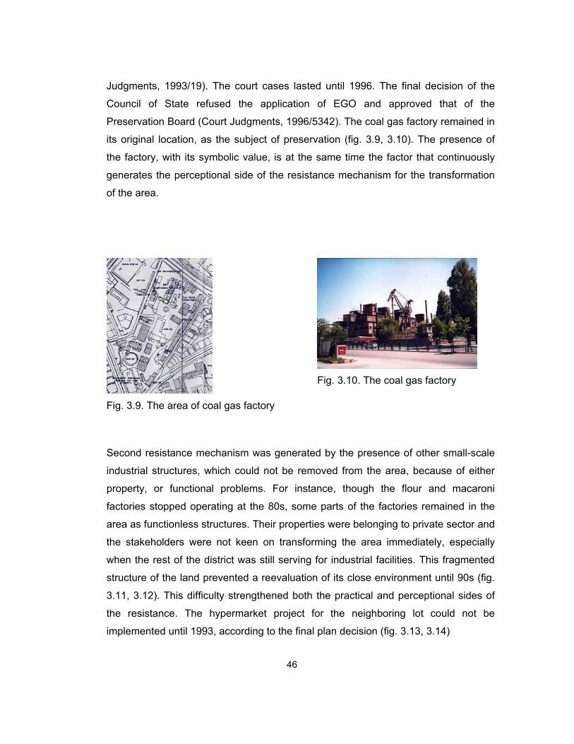
Judgments, 1993/19). The court cases lasted until 1996. The final decision of the
Council of State refused the application of EGO and approved that of the
Preservation Board (Court Judgments, 1996/5342). The coal gas factory remained in
its original location, as the subject of preservation (fig. 3.9, 3.10). The presence of
the factory, with its symbolic value, is at the same time the factor that continuously
generates the perceptional side of the resistance mechanism for the transformation
of the area.
Fig. 3.9. The area of coal gas factory
Fig. 3.10. The coal gas factory
Second resistance mechanism was generated by the presence of other small-scale
industrial structures, which could not be removed from the area, because of either
property, or functional problems. For instance, though the flour and macaroni
factories stopped operating at the 80s, some parts of the factories remained in the
area as functionless structures. Their properties were belonging to private sector and
the stakeholders were not keen on transforming the area immediately, especially
when the rest of the district was still serving for industrial facilities. This fragmented
structure of the land prevented a reevaluation of its close environment until 90s (fig.
3.11, 3.12). This difficulty strengthened both the practical and perceptional sides of
the resistance. The hypermarket project for the neighboring lot could not be
implemented until 1993, according to the final plan decision (fig. 3.13, 3.14)
46

Fig. 3.11. Flour and macaroni factories were shown in a city map in early 90s
Fig. 3.12. The remaining structures of
flour factory (2003)
Fig. 3.13. The lot of the new
hypermarket
Fig. 3.14. The new hypermarket
Nevertheless, not all the facets of the transformation were resisted with different
mechanisms. A private school was decided in 1965 implementation plan. It was
constructed and served for Yükseliş High School until 1973, when it was turned into
a university building with some additional buildings. Today, it is still the building of
Engineering and Architecture Faculty of Gazi University.
47

Fig. 3.15. The area of Gazi University
Fig. 3.16. Gazi University
Fig. 3.17. School (old Yükseliş)
3.2.2 Political Actors at the Transformation
The political actors contributed to the transformation of the industrial production area
were the Directorate of Development and EGO as units of local administration; İller
Bank and Preservation Board in the name of central authority; and Chamber of
Architects. Among these, İller Bank did not play a decisive role within the process
different than what was supposed to do. That role was defined in general as
providing financial and technical support –if required- to the municipalities at the
implementation of development plans after approving the development plans.28
48
28 İller Bank was authorized to approve development plans in the name of The Ministry of Public Works and Settlement between 1949 and 1984. In 1984, this authority was given to municipalities by law 3194.

The political actors and their contributions to the process will be examined under
three headings:
- Local Administration
- Central Authority
- Chamber of Architects
3.2.2.1 Local Administration
The local administration organs, which shaped the transformation of the industrial
production area, were the Directorate of Development and EGO. Both took place in
the process as service units within the supervision of the Municipality of Ankara.
When the Greater Municipality of Ankara was founded superior to new smaller
municipalities in 1984, they became the service units within the Greater Municipality
of Ankara.
3.2.2.1.1. The Directorate of Development
Ankara Directorate of Development was founded in 1928 with extensive authority on
the development of the capital city in early Republican period. It served as an
extension of Ministry of Internal Affairs until 1937, when it was associated with the
Municipality of Ankara. The authority of the directorate was limited within that of the
municipality from then on. The directorate was turned into İmar Daire Başkanlığı
(Development Department) within the Greater Municipality of Ankara after 1984.
The Directorate of Development was responsible from obtaining the master
development plan, preparing implementation plans, determining building codes and
regulations, making required changes and adjustments on the plan, and undertaking
the implementations where necessary. The attitude of the directorate was simply
operational and economical within the whole transformation process.
49

The statements of the directorate, and accordingly of the municipality, revealing the
primary concerns were the decisions in the implementation plan. Having the Yücel-
Uybadin plan obtained, the Directorate of Development prepared first implementation
plans in 1965. The area was divided into definite lots and parcels by that plan. The
intention beyond parceling the area, and also beyond determining the functions and
regulations for those parcels, was not only to realize the transformation decisions in
the most operational way, but also to create a surplus from the re-definition and/or
the sale of the urban land. The surplus gained from the re-definition of the industrial
production area was high, because the area was re-defined as a part of business
district, to which there assumed to be much demand. Moreover, the sale of the land
in parcels was increasing the surplus. Besides, the building coefficients were
determined for high-rise buildings; and that was another aspect that would increase
the surplus. However, the development did not proceed according to anticipations,
and the area failed to turn into a business district as a result of practical reasons
mentioned above. It means that the operational and economical attitude of the
directorate and municipality did not succeed to transform the industrial production
area.
The primary concerns of the directorate and the municipality slightly changed at later
stages of the transformation when the coal gas factory matter was on the agenda.
The concerns, and so the attitudes were revealed in the meeting in November 1990
mentioned above, which was organized to find an agreed solution to the problem of
reevaluating the coal gas factory. The statements of the mayor represented the
general attitude of the municipality, where those of the Director of Development
focused on the feasibility of suggestions for the area and the factory (Archive of
Chamber of Architects, speech deciphers):
- The mayor, Murat Karayalçın, stated that the public reaction was decisive not
only for shaping the future reevaluation of the coal gas factory, but also for
the preservation of the collective memory of Ankara. For him, the municipality
should not create a profit for its self-interest; but, if there was a profit already
occurred, it would not be wrong for the municipality to utilize it. Thus, he
50

argued that a selected project, on which there would be a consensus, could
be a solution satisfying both sides of the argument; it would at the same time
be a gain for the city.
- The director of development, Raci Bademli, stated that the problem had
better be taken into account with its all aspects. He argued that the use of the
area should be balanced within the wholeness of the city; and any decision
either for preservation or demolition should consider the balances within the
city.29 He added that such a decision should be the product of a competition,
to which all actors contribute.
The pure operational and economical concerns of the directorate and the
municipality were substituted with urban, architectural, aesthetic, and environmental
concerns at this stage. It was not only an achievement of the Chamber of Architects,
or a public reaction, but also an outcome of the political stance of the actors. The
social democratic tendency of the actors enabled finding solutions with respect to
social, cultural, and aesthetic values. Nevertheless, continuing court cases and the
changes in political realm interrupted the cooperation between actors. The political
stance of the new mayor and the new administrative board of the municipality after
1994 neglected the opinion of other actors, such as the Chamber of Architects, and
also the public opinion at the urban matters.
3.2.2.1.2. EGO
General Directorate of EGO is the service unit of the municipality of Ankara, which
has been responsible from providing infrastructural needs of the city since the 50s.
Ankara Company of Coal Gas and Electricity had previously taken on this task until
1942, when Ankara Company of Administration of Electricity and Coal Gas was
founded within the municipality depending on the law, no: 4325 (T.C Law #4325). In
51
29 The accessibility of the area with pedestrian roads, and by motor vehicles; the user density in that area, which could be assumed to increase with new functions; the relations of new functions with the close environment, and the distribution of some functions within the whole city were among the factors that would change the balances within the city.

1950, Municipality Administration of Buses, which had been insufficient in providing
the in-city transportation, was joined to the new company so that General Directorate
of EGO was founded within the municipality (Tekeli, 1982: 71). EGO served for
providing electricity, coal gas, and transportation facilities until 1982, when the
administration of electricity was reassigned to state control. Additionally, the coal gas
service was turned into natural gas service beginning from 1989 (www.ego.gov.tr).
EGO appeared as an actor at the transformation of the industrial production area
when the production of coal gas factory ended. Since EGO had possessed the
largest portion of the coal gas factory area (Archive of Chamber of Architects,
06.12.1990), it appeared as an authority to decide on the reevaluation of not only the
structures but also the area of the factory. EGO was the operational actor at the
reevaluation arguments. Yet, there was not a consistent attitude of the institution at
every step; the actions and statements of EGO were diverging.
- After the factory stopped operating, the deconstruction of the structures was
adjudicated immediately. Beyond this operational attitude there was the will
not only to gain an income from the sale of deconstructed material, but also
to prepare the area for possibly forthcoming new buildings. The statement
explaining why the coal gas factory had to be deconstructed was reasoned
on technical and environmental necessities. It was argued by EGO officials
that the soil of the area was polluted 40-50 cm in depth in 60 years of
production; thus, it could be neither kept as it was, nor afforested. (İncirlioğlu,
1991: 84)
- After the Chamber of Architects reacted to the action, and even after the
mayor assured to put an end to it, the operational deconstruction continued.
The statement to justify the continuing action was based on technical reasons
again. The general director of EGO mentioned that although the
deconstruction had stopped at rest of the site, the already started
deconstructions had to be completed. (Archive of Chamber of Architects,
02.11.1990b)
52

The inconsistency became apparent in the meeting mentioned above. Unlike the
operational attitude presented in deconstruction and demolishing of structures of the
coal gas factory, which had already created the confrontation, the statements of the
general director of EGO suggested reconciliation (Archive of Chamber of Architects,
speech deciphers):
- He stated that there was not a definite decision on the area by them; and
they aimed to preserve the present values of the factory and the area.30 He
added that they prepared an exhibition of photographs of the factory, and
were also preparing a documentary film of the area for the aimed
preservation, which would turn into the preservation of memories.
The position of EGO was not clear. In spite of the statements of its general director
in that meeting, the first application by EGO to court was just after the Preservation
Board had decided on the preservation (Court Judgments, 1993/19). It means that
the expectations of EGO were not satisfied with the decision of the board; and thus,
what had been presented in the meeting was a pseudo-care for the values of the
coal gas factory in actuality.
3.2.2.2 Central Authority The sole contribution of the central authority to the transformation of industrial
production area was through the decisions of the Preservation Board.
3.2.2.2.1 Preservation Board
As a unit of Ministry of Culture, Ankara Board of Preservation of Cultural and Natural
Heritage represented the central authority in the transformation of the industrial
53
30 Here the word “they” refers to the mayor and other institutions of the municipality, as well as it refer to EGO.

production area. The contribution of the board was at the final stage of the process
and was about the deconstruction or preservation of the old coal gas factory.
The decision about the preservation of the coal gas factory was the statement of the
Preservation Board (Preservation Board Decisions, 19.03.1991). It was not only
shaping the future developments at the site but also revealing the attitude. The
attitude was objective and communicative; because the decision was given after all
aspects of the subject were examined, and after the opinions of different actors, such
as the municipality, EGO, and the Chamber of Architects, were referred. As a result,
the cultural and historical values were given the first priority and it was decided to
preserve the factory complex as a whole in its original location (Preservation Board
Decisions, 19.03.1991).
3.2.2.3 Chamber of Architects
The contribution of the Chamber of Architects to the transformation of the industrial
production area was at late stages of the process, focusing on the reevaluation of old
coal gas factory.31 Against the operational action by the local administration to
deconstruct the structures within the coal gas factory complex, the Chamber of
Architects developed a reaction immediately in October 1990. In a report prepared
by the Natural and Urban Environment Commission of Chamber of Architects, there
were not only criticisms to the policies of local administration on urban land, but also
declarations focusing on the necessity to preserve the coal gas factory (Archive of
Chamber of Architects, Commission Report). The urban, cultural, environmental, and
also aesthetic values of the factory were taken into account together with the
characteristics of the location. It was argued that the factory was the last existing
component of the industrial area, which had once been the symbol of a technological
and industrial development in the early Republican period. As a result, Chamber of
Architects offered new functions relevant with this symbolic value. (Archive of
Chamber of Architects, Commission Report)
54
31 The distinction between the Chamber of Architects and Ankara Section of Chamber of Architects is ignored in this study; because both were involved with the matter together.

The reaction of the Chamber of Architects sustained even after it had been satisfied
by the decision on the preservation of the coal gas factory as a whole. In 1995 a
special issue of bulletin of Ankara Section was published for declaring the opinion of
the Chamber of Architects about the coal gas factory (Archive of Chamber of
Architecs, Haber Bülteni). Besides presenting the basic concerns again, it was
added that a functionless preservation was not desired; and thus, new and relevant
functions were also offered in the same issue. New functions were suggested in
relation with the potential cultural identity of the area. It was argued that the coal gas
factory could be turned into a Museum of Science and technology, or a Museum of
Industry, or a Culture and environment park. It would be not only a re-functioning for
the factory complex, but also a revitalization chance for the cultural center, which
had already remained away from the urban center (Archive of Chamber of Architecs,
Haber Bülteni). In short, the Chamber of Architects emphasized the symbolic value
of the coal gas factory instead of its use value. This attitude was consistent
throughout the process.
3.3. Transformation of the Industrial Service Area
The industrial service area was the north portion of the old industrial district. It was
surrounded by Talatpaşa Boulevard at north, Atatürk Boulevard at east, railway lines
and Celal Bayar Boulevard at south, and train station at west. (fig. 3.18, 3.19)
Fig. 3.18. Industrial service area from
city map of Ankara
Fig. 3.19. Aerial view of the area
55

3.3.1. Physical Transformation
The transformation of industrial service area was first based on a necessity. The
storage units, railway ateliers, and maneuver lines of railways had already remained
in the midst of old and newly growing urban centers; it was decided to remove them
out of the urban areas. This removal was first spoken about in the report that was
prepared to be the basis of the competition for new improvement plan in 1953. As
mentioned above in section 3.1.1, the competitors were required to consider the area
as the location of the required cultural center. However, the area was not re-defined
with required functions in 1957 Yücel-Uybadin plan, although the ateliers and
maneuver lines were decided to be displaced. The plan decisions on the area were
increasing the density of storage facilities in the area, instead of removing them (fig.
3.20). The decisions for the area were as follows:
Fig. 3.20. Industrial service area in Yücel-Uybadin plan. Continuous lines were used
for new road proposals, where dotted lines were for present ones. Buildings marked with solid black were left untouched.
56

- The maneuver lines of railways, which occupied a large portion of the area,
and also the maintenance ateliers of railways, were removed from the area.
- The area was divided into lots by main and secondary new roads. The main
road was passing through the area on north and south direction, and was
connecting the existing Talat Paşa Boulevard to the proposed Celal Bayar
Boulevard. (fig. 3.20)
- One of the newly created lots was designed as the location of a new fire
station. It was the only new function for the industrial service area. (fig. 3.20)
- The wholesaling marketplace was left in its location with some adjustments
on the service roads nearby. These new roads could be used as well as the
railway lines, for the collection and distribution of goods. (fig. 3.20)
- The rest of the area was allotted to storage units. These units were presented
schematically and were named as “stock warehouses” in general; they were
not specified according to the stored goods in detail. Railways connection
was provided for these units for the transportation of large amount of goods.
(fig. 3.20)
The first condition to be satisfied for realizing these plan decisions was the removal
of maneuver lines of railways. Yet, these lines were not taken out of the area
immediately and the industrial service facilities within the area persisted with their
existing operations until the end of the 70s.
When the urban and environmental factors beyond the transformation are
considered, 1957 Yüvel-Uybadin Plan was not satisfying the necessary requirements
for the industrial service area. Rather, the plan decisions were increasing the
pressure for the transformation. Although these decisions were not implemented
immediately, this pressure was increased by the development of the close
57

environment within the rapid growth of the city. As mentioned above, Kızılay came
up to be the new central business district starting from the 50s. The development of
this new centre continued increasingly between the 50s and 70s. Yet, this
development did not spread towards Anıtkabir and the railways station, unlike the
anticipation stated in the municipality report in 1953. At the beginning of the 70s,
there were two centers in Ankara: Ulus and Kızılay. They were separated from each
other by Sıhhiye. Although it was between the two on the linear spread axis from
north to south, the spread of the centre passed over Sıhhiye and jumped to Kızılay.
The reasons of this pass-over were explained by two scholars as complementary to
each other. Akçura mentioned that the linear zone on east-west direction, formed up
by the intensive green area (Gençlik Park), the industrial storage units, the
university, and the hospitals, constituted a boundary for the expansion of Ulus to the
south, towards Kızılay (Akçura, 1971: 122). It means that the development of Sıhhiye
with central business district functions could only be on the Atatürk Boulevard.
However, as Şenyapılı explained, the buildings on Atatürk Boulevard were
specifically functioned, such as the university building, radio house, İller Bank, Ziraat
Bank, Emlak Kredi Bank, and opera house (Şenyapılı, 1970: 34-35). Since these
buildings could not be re-functioned to serve for central business district functions,
the new centre developed in and around Kızılay, where the built environment could
be re-defined with those functions (Şenyapılı, 1970: 34-35). It means that the present
specific functions of Sıhhiye prevented the development of the area, and passed
over the expansion of the centre to Kızılay. Within this development, industrial
service area could have been transformed so that it would not act as a boundary
between Ulus and Kızılay, but as a transition zone in between. Yet, such a
transformation requirement was not taken into consideration in 1957 Yücel-Uybadin
plan.
The pressure and requirement for the transformation of industrial service area were
turned into transformation recommendations by Ankara Metropolitan Area Master
58

Plan Bureau (AMANPB) starting from the end of the 60s.32 Founded in 1969 to
prepare master plans for Ankara, AMANPB initially made a site-selection study for
the new Adliye Sarayı (Palace of Justice). Among a few possible sites for the new
Palace of Justice, the one in the southeast corner of the industrial service area was
selected depending on the evaluation of various determinants (AMANPB Reports,
13.06.1969).
After this first recommendation to transform a part of the industrial service area,
AMANPB made another study for the rest of the area at the beginning of the 70s
(AMANPB Reports, 01.04.1971). The recommendation of AMANPB for the area was
different than what had already been proposed in Yücel-Uybadin plan, but was a
return to the requirements of the municipality for a cultural center at 50s. AMANPB
revisited the cultural center idea and improved the previous report with the same
basic principles. The new reports prepared between 1971 and 1978 focused on the
grounds for locating a cultural center at the area. The content of the first report,
prepared in 1971, was as follows:
- The area was 350 000 m², and it was large enough to be the area of a
cultural center. It was also considered that the area of coal gas factory at the
south could easily be added to the area of that new project. (AMANPB
Reports, 01.04.1971: 1)
- The cultural center project would include a national library, a national
museum, a museum of contemporary arts, a congress building, an exhibition
building, a theater-opera-cinema complex, hotels, recreation areas, and
auxiliary areas, such as a car park, or service areas. It was argued that all
those functions were already required, or were going to be required in the
capital city of Turkey. (AMANPB Reports, 01.04.1971: 2-3)
59
32 Though AMANPB was in charge of preparing plans, it was given the authority neither for approving nor for implementing those plans. Thus, the studies remain at recommendation level; only after the approval of the ministry they turn into plan decisions.

- The area was easily accessible for both in-city and intercity transportation,
not only by motorized vehicles, but also by trains. Within the city it was on the
most of the public transportation lines, including bus, dolmuş, and suburb
train lines. For its accessibility from outside the city, it was close to both
intercity bus terminal and train station. (AMANPB Reports, 01.04.1971: 3-4)
- The location of the area within the city was advantageous for a cultural
center. It was close to two city centers, Kızılay and Ulus. Besides, it was
surrounded with densely used areas, such as stadium and Gençlik Park at
the north, İtfaiye Square and Anafartalar Street at the north east, university
and faculty buildings at the east, Sıhhiye and Kızılay at south east, and
Maltepe at the south. Moreover, the functions of the existing buildings at
close environment were already related with cultural center facilities.
(AMANPB Reports, 01.04.1971: 4)
- The structures on the area were the maneuver lines and maintenance
ateliers of railways, depots and customs buildings belonging to railways
administration, a private flour factory, the wholesaling marketplace, Tekel
depot, and buildings of Toprak Mahsuller Ofisi.33 Most of those structures had
already been decided to be displaced from the area. It was argued in the
report that the remaining ones should also be removed, for the reason that
the area was then at the city center and the present functions of the area
were not convenient with such a central location. (AMANPB Reports,
01.04.1971: 4-5) (fig. 3.21)
60
33 The other structures, which were not related with industrial service facilities, were the concert hall and the sports hall at the north

Fig. 3.21. The structures present on the industrial service area at the early 70s. The
south of the area, where there was the industrial production area, was illustrated as Kızılay İş Merkezi (Kızılay Business District).
- Finally, the presence of such an area was shown as a chance for the city to
gain a new cultural center. The area was taken as a part of a linear culture
and university zone on the east-west direction, from the university structures
at the east, to the sports and recreation areas at the west, joined with this
new cultural center at the middle. As it was between the two central business
districts, it was going to be fed by the dense use of these centers, while at the
same time joining them with a new function. (AMANPB Reports, 01.04.1971:
5-6) (fig. 3.22)
61

Fig. 3.22. Schematic representation of linear zone proposed by AMANPB.
62
The functions offered by AMANPB for the industrial service area were not different
from the ones required in the report prepared by the municipality in 1953 for the
same place. Nevertheless, the bureau evaluated the cultural center project within the
wholeness of the city. This project was more detailed in another report of AMANPB,
dated to 1973. This report consisted of examination of property ownership on the
area, calculation of the cost of the new project, and evaluation of the feasibility of the
new cultural center project:

- The area was approximately 300 000 m2.34 220 000 m² of it, on which there
were maneuver lines, freight depots, and maintenance ateliers, was owned
by the state railways (TCDD). The maneuver lines and other structures were
already decided to be removed to Güvercinlik. 23 500 m² of the land, on
which there was the concert hall and the wholesaling marketplace, was
belonging to the Municipality of Ankara. 7500 m² was possessed by the TMO.
11 000 m² of the land, on which there was a flour factory, was owned by the
private sector. The rest of the area was including the sports hall and the
uncovered river. (AMANPB Reports, December 1973: 1)
- The value of the land, expropriation cost, the cost of the removal of present
structures, and finally the construction cost of the proposed cultural center
were calculated separately. Depending on these calculations, a relevant
construction coefficient was determined so that the sum of mentioned costs
would not be expenditure. (AMANPB Reports, December 1973: 1-2)
- As a result, it was argued that the transformation of the area with this re-
definition would be serving for the public interest. (AMANPB Reports,
December 1973: 2-3)
Although the necessary preparations and operations for the removal of the
maneuver lines, freight depots, maintenance ateliers, for covering up the İncesu
river, for the expropriation of the privately owned portion of the area were started,
cultural center project of AMANPB could not be realized, because it was combined
with a concept project of the municipality at the end of the 70s.
At the 70s, the Municipality of Ankara prepared another project, which was not
limited with the industrial service area, but taking it as a part of a larger project. It
was named as “Ankara Axis of History / Greenness / Culture / Recreation” (Atabaş,
1994: 30-32). The subject axis was the strip on the east-west direction, from Sıhhiye
63
34 Although it was stated in the previous report of AMANPB that the area was 350 000 m², in this second detailed report it was measured as 300 000 m².

at the east, to the Hippodrome at the west (fig. 3.23). There were also extensions of
that area to the north and south. The project aimed at combining the historical sites
in the city with the places having a symbolic value for the Republic; combining
Atatürk Orman Çiftliği (Gazi Farm) with proposed areas so that a green belt would be
formed at the city center; and assigning cultural and recreational functions to that
belt. (Atabaş, 1994: 30-32)
Fig. 3.23. The project area of the municipality (rendered), including the service area
(highlighted)
The industrial service area constituted a part of that belt between Sıhhiye and
Gençlik Park. There were no specific functions for the area within the redefinition of
the whole axis. Actually there were detailed designs neither for the whole area, nor
64

for some parts of it. Other than the general ideas, the decisions were taken at the
site. In any case, the industrial structures had to be displaced from the area in order
to provide space for that radical re-definition at once and the municipality started a
series of operations on the site, to clear away the old industrial service structures.
The maneuver lines and maintenance ateliers of railways had already been decided
to be removed from the area. The wholesaling marketplace was also decided to
relocate out of the area, and some of the old structures were going to be demolished
for the new Palace of Justice. These decisions were at least suggested by AMANPB
since 1969. The removal decisions were also advantageous for the project of the
municipality, thus the municipality took on the action to clear away the area by
demolishing the remaining structures. Although these operations began on the area,
the project of the municipality could not be realized, because in actuality there was
not an approved project; the only official proposal for the industrial service area was
that of AMANPB. (Atabaş, 1994: 32-35)
At the end of the 70s, another alternative was developed for the area as a
combination of the proposal of AMANPB and the concept project of the municipality.
When the preparations for the 100th anniversary of the birth of Atatürk began, the
representatives from different political institutions came together in a meeting
organized by the Ministry of Culture on 09.06.1978, in order to arrange the
celebrations on 1981 including the establishment of Atatürk Cultural Center (Cultural
Center Sub-Committee Report, 15.06.1978). Formed up by the representatives of
AMANPB in the name of Ministry of Public Works and Settlement, of State Planning
Organization (DPT), of Turkish History Association, and of the Municipality of
Ankara, a committee was founded for the preparations of the cultural center (Cultural
Center Sub-Committee Report, 15.06.1978). After two immediate meetings, the
committee prepared a report which was based on the previous reports of AMANPB
(Cultural Center Sub-Committee Report, 15.06.1978). At this stage there occurred a
disagreement between the representatives of AMANPB and the municipality about
the site-selection of the new cultural center building. The suggestion of the
municipality was to establish the Atatürk Cultural Center project as a part of their
“Ankara Axis of History / Greenness / Culture / Recreation” project on the area of
65

Hippodrome. The projects of AMANPB and the municipality of Ankara were
evaluated separately and as a result, another alternative was derived from the two
former projects. The Atatürk Cultural Center building was going to be on a place
offered by the municipality, where some of the functions will be left at the area
offered by AMANPB, which was the industrial service area (Atabaş, 1994). In spite of
some unavoidable problems between the two institutions, the new alternative
proceeded in terms of necessary expropriations, allotments, signing protocols,
detailing the projects, and even in terms of demolishing some structures. However,
this alternative could not be completed either, because of the coup d’état on
September 12th, 1980, which invalidated the authorities of political actors.
The transformation of industrial service area was re-considered after 1980. Actually,
it was the re-consideration of the whole cultural center project, a part of which was
constituted by the industrial service area. The military government founded Milli
Komite (National Committee) to take on the responsibility to arrange the celebration
of the 100th anniversary of the birth of Atatürk and to establish the Atatürk Cultural
Center (TC Law #2302). Neither the previous project of the municipality, nor that of
AMANPB would be realized as they were.35 Instead, the whole area offered by the
municipality was determined as the area of the Atatürk Cultural Center. The whole
area was formed up by five divisions, and it was the National Committee, who was
then the single authority to decide on each of those five divisions.
The industrial service area was determined as the 4th division of the Atatürk Cultural
Center (T.C. Law #2302, Değişik: 3. Madde) with two exceptions (fig. 3.24). First, the
4th division was limited within the boundary drawn by a new road proposal at east
and south (fig. 3.24).36 Second, the new Palace of Justice was left aside (fig. 3.24).
Although the previous project for the area was invalidated, the old industrial service
structures continued to be either demolished or removed. For instance, Ankara
35 In 1984 AMANPB became a bureau within the municipality. When The National Committee started to decide on the area, the previous plan of AMANPB was utilized, and for the further steps, it was the municipality who prepared the plans.
66
36 The whole area had formerly been divided into two portions that road, which had been designed to connect Talatpaşa Boulevard to Sıhhiye in a curvilinear direction.

Grains Silo, built between 1933 and 37, was demolished in 1986 for providing a plain
land for the new Palace of Justice (Cengizkan, 1994: 87).37 In 1987, a sub-
committee was founded by the decision of The National Committee on 10.01.1987,
which was responsible from preparing suggestions for demolition of old buildings,
constructing new ones, and also for their administration.38 The decisions of both The
National Committee and the sub-committee about the industrial service area were as
follows:
Fig. 3.24. Atatürk Cultural Center Areas. The service area is highlighted.
- In the first meetings of the sub-committee, the primary subjects were the
construction of cultural center building, and also of a new concert hall next to
that building, on the 1st division of AKM areas. (National Committee,
08.02.1985)
37 Although the silo was out of the 4th division of AKM, it was an important component of the old industrial service area.
67
38 This sub-committee, which was also called the technical committee, functioned until 14.12.1990, when its mission and responsibilities were transferred to the Ministry of Culture.

- In the sixth meeting of the sub-committee (20.12.1988) the 4th division
(industrial service area) was shown as the location of a Nature and Science
Museum of TUBITAK, and of a park of the municipality, other than the
existing buildings, sports hall, and the old concert hall of Presidential
Symphony Orchestrate (CSO). Additionally, it was also decided to consider
constructing a chorus practice building in the 4th division. (National
Committee, 20.12.1988)
- In the 4th meeting of the National Committee it was agreed to locate the
chorus practice building at the 4th division. In the same meeting the method to
obtain the project of the new concert hall –in the 1st division- was decided; it
was going to be a limited competition where some selected competitors
would be invited. The sub-committee would be responsible from obtaining
that project. (National Committee, 28.12.1988)
- A report of the Ministry of Culture and Tourism revealed that the ministry had
previously offered to construct the new concert hall in the 4th division, and
wanted the same subject to be considered in the 7th meeting of the sub-
committee. (National Committee, 10.01.1990)
- In the 7th meeting of the sub-committee the new concert hall was decided to
remain in the previously determined place, which was the 1st one. It was also
mentioned that the new concert hall complex, which was decided to include
two buildings of concert and opera, would also form up a complex with the
existing Atatürk Cultural Center building. (National Committee, 10.01.1990)
- In the 8th meeting of the sub-committee, the request of railways
administration to establish a train museum in the 4th division was refused for
the reason that it would increase the density in the area. For the same
division, the request of Atatürk Kültür, Dil ve Tarih Yüksek Kurumu to
construct a congress building and a building for the institution was also
refused for the same reason. (06.04.1990)
68

- Despite the decisions of the sub-committee, in the 5th meeting of the National
Committee, it was decided that the new concert hall of Presidential
Symphony Orchestrate would be constructed on the 4th division, together with
its additional functions. The Ministry of Public Works and Settlement would
be responsible from obtaining the project. Besides, it was reminded that the
outstanding examples of such buildings abroad must be utilized as models of
the new concert hall. For the 4th division, other requests for using the area
were either refused or decided to replace on the 1st division. Additionally, the
sub-committee was abrogated in the same meeting.(National Committee,
14.12.1990)
The last decision of the National Committee was actually the starting point of
debates between the central authority and the Chamber of Architects on how to
obtain the architectural project for the new concert hall. As mentioned above, The
Ministry of Public Works and Settlement was assigned to obtain the project via a
limited competition and implementing it.39 In spite of efforts of a committee, which
was formed by the representatives of Serbest Mimarlar Derneği and Türk Müşavir,
Mühendis ve Mimarlar Birliği, to organize a general competition, the ministry, and
especially the minister, insisted on selecting the competitors to be invited (İdil, 1991:
62-63). 19 architecture offices were invited to prepare proposals, and they were
expected to take the “Gewandhaus Concert Hall, Leipzig” as a model.40 However, as
a reaction to the decisions of the ministry, only 3 of the invited architecture offices
submitted proposals (Archive of Chamber of Architects, 01.06.1991). Consequently,
on 31.05.1991, the ministry declared that the project of the new concert hall was
selected among those 3 projects (public declaration). At that time, the Chamber of
39 It was determined by law that the Atatürk Cultural center areas belonged to the Ministry of Culture (T.C. Law #2876/4). Since the Ministry of Public Works and Settlement had already been responsible from the construction works of state institutions, it was also responsible from the construction of new concert hall, whose property was still belonging to the Ministry of Culture.
69
40 This model was previously offered by Gürer Aykal, who was the conductor of the Presidential Symphony Orchestrate, for the reason that it was technically the best concert hall he had performed in.

Architects reacted not only to the preparations for a limited competition, but also to
orienting the architects to take another existing building as a model (Archive of
Chamber of Architects, 01.06.1991). After a series of debates, it was decided to
organize a national competition, to which architectural offices could now freely
attend. The competition was announced in May 1992, and resulted on October 9th,
1992; The project of Semra and Özcan Uygur was selected among the 46 proposals
(Güzer, 1992: 61). Although the project started to be implemented, its construction
could not be completed because of economical problems. (fig. 3.25)
Fig. 3.25. The future plan of the service area (obtained by overlapping project plan
and 1997 plan)
70
The final decision about the industrial service area was taken while the construction
of the new concert hall was going on. The Preservation Board decided that the old
maintenance ateliers of railways, Cer Atölyeleri, should not be demolished as they
had a historical value. Yet, there were two problems about this preservation decision.

First, it was The National Committee which was to take decisions on the industrial
service area as the single authority. Therefore, the preservation decision of the
board could only be a suggestion to The National Committee to decide on the
preservation in the same way. The suggestion was evaluated in the 7th meeting of
The National Committee and the preservation and restoration of the maintenance
ateliers was decided. The Ministry of Public Works and Settlement was
commissioned to undertake the restoration of the ateliers, which could be re-
functioned as a Museum of Fine Arts and Art Workshops (The National Committee,
04.08.1995).
Second problem was about the restoration, because the area had already been
utilized for the new concert hall project, and the old maintenance ateliers had not
been considered in that project. Initially the architects of the new project were
informed by the Ministry of Public Works and Settlement, on 13.06.1996. Following,
Preservation Board decided to suggest requesting the restoration projects of the
ateliers from who had prepared the winning proposal for the new concert hall
(Preservation Board Decisions, 25.11.1996). As a result, not only the concert hall
project was revised to include the restoration, but also the restoration of
maintenance ateliers was given to the same architects. Thus, the maintenance
ateliers were also joined to the project of the new concert hall as a museum of
contemporary arts. (fig. 3.26, 3.27)
Fig. 3.26. Maintenance ateliers of railways before restoration
71

Fig. 3.27. Ateliers after restoration, as a museum of contemporary arts
At the final situation, the transformation of the industrial service area was concluded
in terms of decisions on the process. Nevertheless, the physical transformation is still
incomplete, because the construction of the new concert hall has been paused. The
concert hall project signified the main structural change of the area. The change in
the function, physical and social situation of the area is dependent on the realization
of this new project; and unless the construction of the concert hall is completed, the
intended transformation of the area will not be accomplished.
Fig. 3.28. Present situation of the service area
Fig. 3.29. Sports hall
Fig. 3.30. Current concert hall
72

3.3.2. Political Actors at the Transformation
The political actors contributed to the transformation of the industrial service area
were the Municipality of Ankara as the local administration; AMANPB, The National
Committee, and Preservation Board, and ministries in the name of Central Authority;
and Chamber of Architects. The political actors and their contributions to the process
will be examined mainly under three headings:
- Local Administration
- Central Authority
- Chamber of Architects
3.3.2.1. Local Administration
The Municipality of Ankara was the local administration who contributed to the
transformation of industrial service area. These contributions may be examined in
two periods.
At first stage, the municipality prepared a report for the new improvement plan of the
city in 1953 (Ankara Belediyesi, 1954a).41 This report was important for drawing the
initial framework of the transformation of the area before the plan competition. It was
advised to the participants to consider the replacement of not only maneuver lines
and ateliers of railways, but also of the storage units and other service structures
(Ankara Belediyesi, 1954b: 118-119). By this way the area could be regarded as a
gateway to the required cultural center, or as a part of it. On the other hand the
cultural center requirement of the municipality was much more effective on the
process. Although this requirement had not been fulfilled in the selected
improvement plan of Nihat Yücel and Raşit Uybadin, it provided a base and an idea
for the future development possibilities of the area at the 70s.
73
41 The report was prepared in 1953, and was published in 1954 in Turkish, English, and French.

The second period when the municipality contributed to the transformation of the
area was between 1973 and 1980. At this period of seven years, two different
administrative boards and mayors were in charge: it was Vedat Dalokay between
1973 and 77, and Ali Dinçer between 1977 and 80 (Altaban, 1998: 57-59). These
two mayors and administrative boards had similar social democratic political stances.
But it was Ali Dinçer and his colleagues who contributed to the transformation of the
industrial service area with a large scale project. The industrial service area
constituted a part of the “Ankara Axis of History / Greenness / Culture / Recreation”
Project. The attitude of municipality at this period was reflected on the project they
prepared. The municipality intended to reserve a vast area of 1 400 000 square
meters for this project (Atabaş, 1994: 30-32). Although the whole area could easily
be re-defined with more profitable functions and municipality could hold that profit,
the preferred functions were still based on social, cultural, and environmental
concerns, instead of economical ones.42 Nevertheless, the attitude of the
municipality was still operational. The project was not developed on common
grounds, where the public, the other political actors, and also the universities meet;
and additionally it was not implemented according to a detailed and approved plan,
because the municipality was not authorized to prepare plans at that period.
Besides, there is no information about the researches on the feasibility of the project.
Despite the lack of preparations at the background, the municipality attempted to
implement the project in the most operational way. Yet, the operations did not help
the project to be realized immediately. On the contrary it may have created some
unavoidable confrontations between political actors. If such an attitude affected the
transformation of the industrial service area, it was nothing but the removal of some
of the existing structures from the site. There was again a resistance to the
displacement of the structures. For instance, the wholesaling marketplace was
standing as the hardest function to be replaced at another part of the city, because
that original area was already very much advantageous for the shop owners in terms
74
42 When there was a confrontation between the actors about the cultural center subject, the municipality was accused of preparing the project for the sake of gaining a profit from the re-definition of the functionless areas belonging to the municipality.

of accessibility. However, the municipality offered a new building for the same
function according to the approved improvement plan and persuaded them to
replace their stores in a new location provided by the municipality (Atabaş, 1994:
32). The intention of the municipality was to clear away the area as soon as possible
so that the project could be realized in a short time. The project could not be
realized, but the operational actions of the municipality avoided a possible resistance
to the forthcoming stages of the transformation. Additionally, the whole area was
determined to be the area of Atatürk Cultural Center by The National Committee
after 1980. It means that the project of the municipality was not totally abandoned;
on the contrary it provided a base for the future development of not only the
industrial service area, but also the whole line extending from Sıhhiye to
Hippodrome.
The contribution of The Municipality of Ankara to the transformation of the industrial
service area continued after 1980 in terms of preparing necessary plans required by
The National Committee.43
3.3.2.2. Central Authority
The effects of the central authority on the transformation of the industrial service
area had been through three units:
- Ankara Metropolitan Area Master Plan Bureau, within the supervision of
Ministry of Development and Settlement
- National Committee
- The Ministry of Public Works and Settlement
- Preservation Board within the supervision of Ministry of Culture
In addition to those actors, Ministry of Culture took place in the process also as itself.
Yet, its position and contribution was not more than a property ownership of Atatürk
Cultural Center areas, as defined by law (T.C. Laws, #2876/4)
75
43 It was The Greater Municipality of Ankara after 1984.

3.3.2.2.1. Ankara Metropolitan Area Master Plan Bureau (AMANPB)
In 1950s, the political organization began to remain insufficient against the
unexpected rapid urbanization, and its harmful effects. Some institutional
arrangements had to be made in order to make its actors capable of solving the new
problems. One of those new actors was the Ministry of Development and Settlement
that was founded in 1958 (Tekeli, 1998: 13). Planning regions, cities, towns, and
villages was among the responsibilities of the ministry. In 1965, the ministry was
required to found bureaus within its own organization in order to obtain master plans
for İstanbul, Ankara, and İzmir, where the urbanization is more rapid and unhealthy
than the others. After the first two, which had been founded in Istanbul and İzmir, the
one in Ankara was established in 1969. The authority to prepare improvement plans
were taken from the municipalities in 1972 and Plan Bureaus remained as the single
authority in the planning of those three cities. However, Plan Bureaus were not
authorized to approve or implement the plans. It was the ministry to approve plans,
and the municipality to implement them. (Altaban, 1998: 56-57)
After its foundation, the first study of AMANPB, concerning the transformation of the
industrial service area, was about the site-selection for the new Adliye building. It
was offered to locate the new building at the southeast edge of the area, which had
previously been allotted for a fire station in Yücel-Uybadin plan. The following study
related with the area was about the cultural center project. Depending on the report
of the municipality dated to 1953, AMANPB improved the ideas of the municipality,
and made a series of researches on the possibility of a cultural center on the area.44
The outcomes of these researches were reported between 1971 and 1978 as
mentioned above in section 3.3.1. It was offered to construct a cultural center with all
76
44 Although it is not clearly spoken, the similarities between the report of municipality in 1953-54 and that of AMANPB in 1971 prove the fact that AMANPB dwelled on the ideas of the municipality, and improved them as a project.

related functions at the industrial service area. The main objective of the cultural
center study was to evaluate the area at the centre of the city for public interest.45
Although this offer did not turn into a decision immediately, it had been effective on
the transformation of the area. Its practical effect was the expropriation of the
privately owned part of the area according to the reports of AMANPB. Its indirect
effect was to put the cultural center subject on the agenda again. After the reports of
AMANPB, it was considered to build a cultural center in Ankara, within the context of
celebration of the 100th anniversary of the birth of Atatürk. Although the cultural
center building could not be located in the place offered by AMANPB, the area was
re-defined with similar functions after 1980.
The attitude of AMANPB was shaped by the technocrats who made the research
and planning studies for Ankara. These technocrats of AMANPB were the architects,
planners, and other experts, most of whom were also scholars. Probably as an
outcome of their scientific attitudes in universities, the studies of the Master Plan
Bureau were constructed upon extensive researches. The attitude of these
technocrats was reflected as that of AMANPB on the transformation of the industrial
service area: it was technical and rational, rather than being political or economical.
In the case of cultural center proposal, the necessary functions were borrowed from
the earlier report of the municipality; still, the relevance of these functions was
questioned within the wholeness of the city. The proposal was developed with
contextual references. The feasibility of the project was investigated not only in
economical terms, but also in terms of possible social changes in and around the
area. Besides, all the preferences were based on rational grounds and scientific
calculations as much as possible.
77
45 Haluk Alatan, the chief expert of AMANPB, stated in an interview that TCDD, the owner of the largest portion of the industrial service area, could have aimed at gaining an income from the sale of the land in parcels, and the intention of AMANPB was to prevent such an operation (Alatan, 1992: 20).

3.3.2.2.2. National Committee
Milli Komite (National Committee) was the single political actor who had authority on
the transformation of the industrial service area after the coup d’état of 1980.
Founded by law, dated to 23.09.1980, it was formed up by the president, the
representatives of central authority, and representatives of the army (T.C. Law
#2302). It was responsible not only from making necessary arrangements for the
100th anniversary of the birth of Atatürk, but also from the establishing Atatürk
Cultural Center in Ankara. A sub-committee served for preparing proposals for the
cultural center areas between 1987 and 1990. Yet the attitudes of the sub-committee
and the National Committee were diverging.
The sub-committee was formed by the minister and undersecretary of the Ministry of
Culture and Tourism, three members of the National Committee, and additionally by
the experts, who could be invited where necessary. The sub-committee was not only
preparing proposals, but also serving as an intermediary organ between the National
Committee and other related institutions, such as the municipality. The attitude of the
sub-committee was primarily shaped by technical issues. When preparing proposals,
the requirements, necessities, possibilities, sufficiency and insufficiencies were
considered as much as before the political concerns.
On the other hand, the attitude of the National Committee was much more political.
Since it was formed by the representatives of the central authority at ministers’ level,
the primary concerns were political, not urban or cultural. This attitude was revealed
in site selection decision for the new concert hall. It had already been planned to be
on the 1st division of Atatürk Cultural Center areas. Although there was no such
suggestion by the sub-committee, in the 5th meeting of the National Committee, the
concert hall was decided to be constructed on the 4th division, which was the
industrial service area. The reasons for this change in the site selection were an offer
by the Ministry of Culture and Tourism, and the preference of Gürer Aykal, who was
the conductor of Presidential Symphony Orchestrate. The new site selection was not
reasoned on calculations or necessities but political and personal preferences.
78

3.3.2.2.3. The Ministry of Public Works and Settlement
The Ministry of Public Works and Settlement was a combination of two previous
ministries, Ministry of Public Works and Ministry of Development and Settlement.
The Ministry of Public Works was founded in 1920 as “Nafıa Vekaleti”. Its
responsibilities were defined as constructing railways, harbors, motorways, and
bridges, arranging water affairs, and managing any construction of state
organizations in 1934. The Ministry of Development of Settlement was founded in
1958. It was responsible from planning regions, cities, towns, and villages, focusing
on housing policies and construction materials, taking necessary measures before
and after disasters, providing urban infrastructures, and arranging the relations with
municipalities. These two ministries were combined to form up the Ministry of Public
Works and Settlement in 1983. (www.bayindirlik.gov.tr)
Though The Ministry of Development and Settlement had previously contributed to
the transformation of the industrial service area through AMANPB at the 70s, the
actual effect of Ministry of Public Works and Settlement was when it was charged by
the National Committee for obtaining the project of the new concert hall.
Not only the role of the ministry, but also the story of the project of a new concert hall
took place on a newspaper as follows: in actuality, it was the president, Turgut Özal,
who gave the instruction to the Ministry of Culture to get the new concert hall
constructed until 1993, the 70th anniversary of the foundation of the Republic. The
Ministry of Culture took this instruction to the agenda of the National Committee in its
5th meeting, and it was decided there to obtain the project of the concert hall
immediately. The area, which had already been reserved for the concert hall among
the five divisions of the Atatürk Cultural Center areas, was the 1st division, as
mentioned above. However, in the same meeting, this site-selection decision was
changed according to the personal preference of the conductor of the Presidential
Symphony Orchestrate, Gürer Aykal, and it was decided to construct the new
concert hall on the 4th division, which was the industrial service area. The Ministry of
79

Public Works and Settlement objected this decision for the reason that there had
been no preparations on the 4th division for such a project, and for the reason that it
would take time to make these necessary researches and preparations. Insisting on
the decision to locate the new concert hall on the 4th division, it was discussed to
take a model for the new project. At that stage, Gürer Aykal suggested taking the
Gewandhaus Concert Hall, Leipzig, as a model for the one to be constructed in
Ankara; because it was the best concert hall he had performed in, in terms of
technical and acoustical conditions. The possible delays at technical preparation
stage and also at obtaining an architectural project were going to be prevented at an
initial level by accepting this suggestion. The Ministry of Public Works and
Settlement was assigned to obtain the project. (Önal, 1992)
At the preparation stage of the competition, it was stated that the participants of the
limited competition, and also the selecting committee were going to be decided by
the ministry itself. Additionally, it was spoken that this selecting committee was not
going to serve as a jury, but as an advising organ; and the final selection among the
submitted proposals was also going to be done by the ministry and the minister
himself. Actually, this was nothing but a personal political attitude that ignored any
authority other than the minister himself. (İdil, 1991: 62-63)
3.3.2.2.4. Preservation Board
The contribution of the “Ankara Board of Preservation of Cultural and Natural
Heritage” to the transformation of the industrial service area was at the final stage,
about the maintenance ateliers of railways. It was decided on 19.06.1995 that the
remaining structures of the maintenance ateliers should be preserved, because not
merely these structures, but the whole area had a peculiar characteristic in terms of
urban and architectural heritage of the Republican period.46 (Preservation Board
Decisions, 19.06.1995)
80
46 This decision was reasoned on the same grounds for the previous preservation decision of the board about the coal gas factory, taken on 19.03.1991.

The attitude of Preservation Board was technical and objective, as had been in the
case of preservation of coal gas factory. Actually these two decisions were
complementary for each other: what had been stated in the preservation of coal gas
factory was emphasizing the historical and cultural value of the area, not merely the
factory (Preservation Board Decisions, 19.03.1991), and the maintenance ateliers
were components of the same area, the old industrial district.
3.3.2.3. Chamber of Architects
The contribution of the Chamber of Architects was at the stage of obtaining a project
for the new concert hall on the old industrial service area. The Ministry of Public
Works and Settlement, which was charged by The National Committee, aimed at
obtaining the project via a limited competition. The reaction of the Chamber of
Architects was focusing particularly on two points.
First, the preferred way to obtain the project was discussed. On one hand it was
argued to be conflicting with the law (T.C. Laws, #2886). According to this law, the
authors of a project could be selected either by a competition, or by evaluating the
competitive prices offered by the applicants. The Chamber of Architects argued that
the project selection of the Ministry of Public Works and Settlement was not legal
since it was not convenient with any of these two ways defined by law (Archive of
Chamber of Architects, 31.05.1991). However, there was a decision of the Council of
Ministers (25.01.1991) that let the Ministry of Public Works and Settlement to
disregard that law for the special conditions of concert hall project, which actually
made the first argument of the Chamber of Architects irrelevant for the case (Archive
of Chamber of Architects, 05.07.1991). On the other hand, the attitude of the minister
and The Ministry of Public Works and Settlement was criticized for ignoring any other
authority in the selection of the project. The authority to select an architectural
project could only be a jury, in which there should have been experts from
architectural realm.
81

Second, the authenticity of the new concert hall was questioned, because the invited
participants of the limited competition had already been oriented to take the
Gewandhouse Concert Hall, Leipzig, as a model for their proposals. The Chamber of
Architects argued that this attitude was conflicting with the law (T.C. Laws, #2302). In
that law it was mentioned that the Atatürk Cultural Center areas must be evaluated
with projects, which would be the symbols of the Republic. For The Chamber of
Architects, such an oriented project could neither be authentic, nor become a symbol
of the Republic. (Archive of Chamber of Architects, 01.06.1991)
The Chamber of Architects turned the reaction of 16 of 19 invited architects, who had
not submitted any proposals to the ministry, into a public reaction. In the first week of
June 1991, which was the week after the ministry had declared that the project of the
new concert hall was selected among those 3 projects, the subject appeared on
newspapers, and was assessed by the critics (Mumcu, 1991; Soysal, 1991), after the
press decleration of the Chamber of Architects on 21.05.1991. As a consequence of
rising reaction to the attitude of the minister and the Ministry of Public Works and
Settlement, the competition was re-organized as a national one, which was at the
same time accessible to all Turkish architects.
In general, the Chamber of Architects presented an attitude that defended the basis
of the profession of architecture. As a result, the gaining was not of The Chamber of
Architects, but was of the profession, and also of the cultural realm.
82

Fig. 3.31. The flowchart of the transformation of the industrial district
83

CHAPTER 4
COMPARATIVE EVALUATION
The two-sided characteristic of the transformation of the old industrial district enables
a comparison between the transformations of the industrial production and service
areas. It will be a comparative evaluation on two realms: political, and urban and
architectural.
4.1. Comparative Evaluation in the Political Context
The transformation of the industrial district was impending at the 50s. The
unexpected growth of the city made it inevitable to re-define the industrial district with
new functions. The political actor who was responsible from this re-definition was the
Municipality of Ankara. It was required from the participants of the new development
plan competition to consider the area as subject to transformation. It meant that the
municipality aimed to accelerate the process before the transformation pressure
increased. Having the development plan obtained and approved, the designers of
the selected plan were joined to the political actor. Yet, the district was divided into
two areas in the approved Yücel-Uybadin plan, and these two areas were
approached differently from each other.
On the one side, the pressure for the transformation of the industrial production area
was avoided at decision level before it got stronger. The method to avoid was re-
defining the area with new functions relevant for a city center. Since the decisions
were not confronted by another political actor at the initial stage, the transformation
started at physical level. Nevertheless, there were resistances to the transformation
at either practical or perceptional grounds. The factories remained at the site, and
prevented the area from turning into a business district. It was not only a practical
84

and physical resistance, but also a perceptional one. Although the municipality, as a
political actor, positioned itself for transformation of the area, the resistance
mechanisms were at least as strong as the intention or necessity beyond the
transformation. The resistance mechanisms were generated by unavoidable
necessities. Thus, the transformation of the industrial production area sustained until
these resistances diminish, namely until the coal gas factory stopped operating. It
was not before the 90s that the reasons of resistance disappeared. But this time
another resistance came into existence. The old coal gas factory was then a
historical structure, and it was argued that it had symbolic value. The new resistance
was stimulated by another political actor, The Chamber of Architects. There occurred
a confrontation between the political actors, and from then on the transformation
process became the object of authority relations. Since The Chamber of Architects
did not have the authority to decide on the problem, it generated the resistance
mechanisms on two realms. First, a public opinion was developed. It was important
because the municipality had already been authorized by the same public, and the
mayor was declaring that they did not have the right to ignore the public opinion.
Second, the Preservation Board was added to the process as another political actor,
which also had the authority to decide in the name of the central authority. After the
board decided on the preservation of the coal gas factory, it meant an end for
authority relations on the transformation of the industrial production area.
On the other side, there was also a pressure for the transformation of industrial
service area at the 50s. In Yücel-Uybadin plan, not the transformation of the area
was but some arrangements were considered. Moreover, the number and the
density of the service structures with similar functions were increased on the
industrial service area. Consequently, the municipality, as a political actor, appeared
as if it positioned itself for resisting the impending transformation. The municipality
previously stated in 1953 report that the area should have been transformed into a
cultural center area. It meant that the previous position of the municipality was for
avoiding the pressure for transformation. But when the 1957 plan was approved and
the planners of that plan joined to the political actor, the position of the municipality
was shifted to that of the designers, who ignored the pressure for transformation at
85

the industrial service area. The pressure sustained increasingly until the 70s, when
another political actor contributed to the process. It was AMANPB within the
supervision of the Ministry of Public Works and Settlement. Yet it was not a
secondary actor; the authorities of both the municipality and plan bureau were so
defined that there could not be a confrontation between them. The plan bureau was
responsible from preparing plans, but did not have the authority to approve or
implement them. The municipality did not have the authority to prepare or approve
plans, but was responsible for implementing them. Thus, when the plan bureau
prepared a proposal for a cultural center on the industrial service area, it was not
confronted by the municipality, or by any other political actor. Actually, the cultural
center idea had already been put forward by the municipality in 1953 report; there
was not a new idea, or complete project of the plan bureau, but a series of reports.
The last report of the bureau was dated to December 1973. It is known that the
preparations for a cultural center started on the area for providing land for the
proposal. At that period the position of the municipality was also for the
transformation of the industrial service area. The area constituted a section of the
“Ankara Axis of History / Greenness / Culture / Recreation” project of the
municipality. Since the municipality was not authorized to prepare plans, it was only
a concept project, but it was initiated in the most operational way. In 1978, the
proposal of AMANPB and the project of the municipality turned into a cooperative
project for the Atatürk Cultural Center. This cooperation was formed up with several
institutions, associations, and with the Municipality of Ankara. The confrontation
emerged within this cooperation, between AMANPB and the municipality about the
site selection for the cultural center. This time the confrontation was not about
whether to transform the area or not, but about how to transform the area. There
were two suggestions: the plan bureau was aiming to establish the cultural center on
the industrial service area, the municipality was to do so in another area and to re-
define the service area with another function. This confrontation did not remain
limited with these two actors, but the Ministry of Public Works and Settlement, The
Ministry of Culture, the General Staff Presidency (Genelkurmay Başkanlığı), and the
prime minister were also included into the debates. As a result, the confrontation
resolved by the decision of the prime minister. The political actors on the
86

transformation totally changed after the coup d’état of September 12th, 1980, just as
the whole political realm in the country. The new military government founded The
National Committee to undertake the responsibility of arranging celebrations of the
100th anniversary of Atatürk’s birth. The cultural center was taken within the same
organization, and The National Committee was also responsible to establish Atatürk
Cultural Center. A technical sub-committee was founded within The National
Committee, to prepare suggestions for the evaluation of Atatürk Cultural Center
areas. These two were acting as a single political actor, and were requesting the
operational cooperation of some others where necessary. For instance, the
municipality was preparing requested plans, the Ministry of Public Works and
Settlement was undertaking the necessary construction works, and so on. There was
not a confrontation between them because the committee had already been
including the representatives of other political actors.47 It was a consensus dictated
by law. This consensus was violated when the new concert hall was on the agenda
again in 1990-91. the personal desires of the president, the personal preferences of
the conductor of the Presidential Symphony Orchestrate, the personal and political
attitude of the Minister of Public Works and Settlement created the confrontation not
only within the National Committee, which actually resulted with the abrogation of the
sub-committee, but also between the Ministry of Public Works and Settlement and
the Chamber of Architects at the following stages. The ministry was speaking in the
name of The National Committee, where the Chamber of Architects was in the name
of the public, or at least in the name of architects. As a result of the public reaction to
the practices of the ministry for obtaining the project of a new concert hall in the
area, the ministry stepped backward and prepared a competition, and so the
confrontation resolved in the favor of the Chamber of Architects. Finally in the
transformation of the industrial service area, the Preservation Board played an
effective role for providing The National Committee with a decision on the
preservation of old ateliers of railways. The old ateliers were re-functioned as a
museum of contemporary arts at the final stage.
87
47 Although the municipality was not represented in the committee, the mayor or a technical official was usually invited to the meetings.

When considered together, the transformation of the industrial service area was
much more shaped by the contributions of the political actors, than that of the
production area. Both transformations have remained incomplete.
For the production area, the reason of incompleteness was primarily the misstep of a
political actor, the municipality. Although the pressure for transformation was avoided
initially by the municipality at the decision level, it was not a comprehensive decision
for the total production area. The factories remained at the site as the elements of a
resistance to the transformation, which finally resulted in a fragmented structural
change in the area. The municipality could have considered the possible resistances
to transformation, but could not. It was the reason beyond the failure to transform the
industrial production area.
For the service area, the reason of incompleteness was actually the number and
variety of the political actors, who contributed to the process at different periods. The
number of the actors prevented a single decision to be taken for the transformation
of the area. The variety of the actors resulted with confrontations when decisions
were taken at different periods. When the number and variety of actors were
decreased to minimum after the coup d’état, the newly defined actor, the National
Committee, could not solve the problem because it was an idle actor for urban
issues. Although it was powerful enough, it lacked a practicing unit for the operations
at the urban areas. That was why a sub-committee was founded, and other political
actors were requested to cooperate. The new actor could only function on the urban
realm with the assistance of other definite actors. However, when other definite
actors joined to the process, their political attitude prevented the necessary
operations to be done for the transformation in a rational way. In short, it was the
resistance of political actors to each other that made the transformation of the
industrial service area remains incomplete.
88

4.2. Comparative Evaluation in the Urban and Architectural Context
The conditions of transformation processes also set the conditions for architectural
production in both of the areas.
On the industrial production area, these conditions were usual. The land, which had
been attempted to clear away from old structures, was divided into lots and parcels.
The relevant functions were decided, the building regulations were determined so
that the area was going to turn into a business district with new high-rise office
buildings. It could be expected that those buildings would utilize the maximum area
and rise as much as allowed in order to maximize the profit. In such production of
buildings, the architectural production would be limited with the constraints of the
plan, and also be compelled with the requirements of the employer. The maximum
area that could be occupied for buildings, their minimum distances from the
surrounding roads, construction coefficients, and other regulations were all definite
constraints, within which there remained limited options for architectural production.
Nevertheless, these constraints could be surpassed by combining the parcels and
re-defining the regulations. For instance, in the case of the hypermarket, four
parcels, which had previously been drawn in 1965 implementation plan, were
combined so that a larger single parcel could be obtained; and after a decision taken
on the plan in 1993, that new parcel was allotted to a hypermarket. Although there is
no architectural peculiarity of that hypermarket, at least it was proved that the
parceling could be reversed. Another example from the same area is the school
building, which today belongs to Gazi University. The area of that building was
allotted for this function from the beginning that neither parceling the area nor the
reverse action had to be gone through. Its architectural quality may be questioned,
but it is clear that there were more than one opportunities for architectural production
in that case. The case of coal gas factory could also be an outstanding example
against not only the parceling attitude, but also the demolishing and re-building. If
only the cooperation of the municipality and the Chamber of Architects had
succeeded, the area of the coal gas factory could be evaluated with a combined
project, where there would be re-functioned factory structures and new buildings.
89

The constraints set by the process could be surpassed by re-defining the process
not solely with economical concerns, but with urban, environmental, architectural,
and aesthetic concerns.
For the industrial service area, the conditions were different than those for the
production area. First, after it was decided to transform the area, it has never been
thought to divide the area into lots and parcels. All the political actors, who
developed projects for the area, considered the area as a whole for those large-scale
projects. Actually it was one of the rare cases where the authorized political actors
desired to evaluate a large undivided area with significant urban and architectural
projects. The proposals of both plan bureau and the municipality at the 70s were
eligible projects in urban, environmental, and architectural terms. Yet, they remained
unrealized as a result of confrontations between the political actors. When the
service area was considered as the 4th division of Atatürk Cultural Center areas, it
was made definite by law that this area would be evaluated with a significant project
which represents the ideals and principles of Atatürk (Law no: 2302). Some of the
requests from The National Committee to reserve the area for some other functions
were refused by the National Committee for the reason that they did not take place in
that definition of the area. Finally, it was decided that the area would be the location
of the new concert hall. Leaving all the debates around the site selection for concert
hall aside, it was still a chance to obtain a significant architectural project. Although
there emerged confrontations on how to obtain such a significant example, they
dissolved in the way that let an architectural competition. As a result, the conditions
were so set for architectural production that the constraints were decreased to
minimum; the opportunities were increased to maximum. Additionally, there was the
chance to select the best example of the architectural production of the time. The
selected project of new concert hall could include all the urban, environmental,
architectural, and aesthetic properties which architectural realm could produce.
Nevertheless, the architectural production was then limited with economical
constraints at construction stage.
90

When considered together, it is clear that the position of the architectural production
in an urban transformation is determined mostly by the political realm, and by the
involvement of the architect in the process as a political actor, or at least as a
component of it.
In the case of industrial production area, there were two cases, which resulted or
could have resulted with obtaining architecturally valuable buildings. One of them
was the school building example, where the architectural production was considered
by a political actor from the beginning. The other case was the reevaluation attempts
for the coal gas factory, where the political actor, namely the municipality, was forced
by another political actor, the Chamber of Architects, to consider architectural
production in the transformation. Although these attempts remained insufficient to
obtain significant urban and architectural examples, they at least prevented the
monotonous production of the urban fabric to reproduce itself on that area. For the
rest of the area, the architectural production was not so much a concern of any
political actor from the beginning. The architectural production was limited with many
constraints, and the production of new buildings was left to urban fabric in small
parcels. If there had not been practical resistance factors to transformation, these
parcels could have been completely utilized and the production of the urban fabric,
which resulted with similar apartment blocks suitable for various functions, could
reproduce itself in this area.
For the industrial service area, the urban and architectural quality has always been
considered by any political actor. When it was close to be ignored, the Chamber of
Architects reacted to the situation as the political actor representing the architects.
Even though the project could not be realized yet, the transformation process of
industrial service area exemplifies how valuable projects can be obtained when
architectural production is a concern of the political actors.
91

CHAPTER 5
CONCLUSION
There are a number of conclusions to be drawn from the examination of the
transformation of the old industrial district of Ankara. These conclusions will be
employed in questioning the possible approaches for the similar forthcoming
transformations, with respect to the political framework and the position of
architectural production within the same framework.
First of all, an outline of urban transformation processes can be drawn by
generalizing the steps and/or missteps of the transformation of the old industrial
district of Ankara. As mentioned above, in designed urban transformations, when the
transformation pressure and resistance meet, or even when the transformation
requirements come into existence, the authority decides whether or not the
transformation should be exercised. It is the political agent who makes this decision
at the urban scale. If the transformation is decided to be exercised, the first task of
the responsible political agent should be to make necessary researches on the area,
in order to construct a relevant strategy for the transformation, and also in order to
achieve reliable anticipations. These researches may well be expected to reveal the
possible difficulties standing, or which could stand, against the transformation by
generating resistance mechanisms. If only such difficulties can be foreseen
depending on these researches, it would be possible to avoid them at an initial
stage, before they turn into resistances. Having the relevant strategy determined and
the anticipations defined, the second task of the authority should be to obtain a plan,
or a project for the transformation. The designer, either architect or planner, joins the
process at this stage, either by undertaking the authority transmitted by the political
agent, or by participating in the political agent as a technocrat. This thesis shows that
not only obtaining the design, either the plan(s) or the project(s), but also the
92

approval of it, is an important step in the process. The approval of “design” is again a
matter of authority on the urban realm. It may be the same agent who is responsible
for both obtaining and approving the design, as well as they may be different agents.
Having the design obtained and approved, the final step of the transformation is the
implementation. Similar to the approval stage, the implementation of the design may
result with the contribution of another political agent on the process. If the
implementation is the responsibility of an authority different from the one(s) that of
who obtained and/or approved the design, there appears another agent at the final
stage.
The incompleteness of the transformation of the old industrial district can be
explained with the missteps within the process.
- For the industrial production area, the first step of the transformation was
missing: there was not an extensive research at the beginning. Despite a
report was prepared by the municipality, it was not an outcome of an
extensive research. The lack of researches actually prevented the possible
difficulties to be foreseen at the industrial district case, and these difficulties
generated resisting mechanisms to the transformation at the implementation
stage. In the second step, the plan was obtained; and yet, there were only
piecemeal transformation decisions for the area. These piecemeal decisions
and resistance mechanisms caused the final step; the implementation of the
plan remained incomplete. It was a partial transformation for the industrial
production area at the end.
- For the industrial service area, there was not an extensive research at the
beginning. The relevant strategies could not be developed; the reliable
anticipations could not be achieved, since the report prepared by the
municipality was not depending on an extensive research.48 Additionally there
93
48 At least the anticipation that Anıtkabir and the railways station was going to be the new center of the city proves that the researches, on which the report was constructed, were far away from being rational.

were no decisions for the transformation of the industrial service at all. The
transformation process restarted by AMANPB since it was not even initiated
by Yücel-Uybadin plan. At the first step, the Master Plan Bureau made the
necessary researches extensively. The possible difficulties were found out,
and precautions were taken to prevent them to turn into resistance factors at
the following stages of the process. However, the second and third steps of
the process, approving the plan and implementation, were not totally within
the authority of AMANPB. In the meantime, the municipality also attempted to
transform the area; but the first and second steps of a transformation
process, research and design, were lacking in this attempt. When the
National Committee was assigned to undertake the process, there was the
research of AMANPB, the suggestions and concept projects of AMANPB and
the municipality; but there was not an approved plan, or project, and
additionally the National Committee lacked an operational unit to realize any
proposal. At the final situation, after an approved architectural project had
been obtained by the Ministry of Public Works and Settlement according to
the decision of the National Committee, the last step of the process, the
implementation, could not be realized because of economical problems.
The examination of the transformation of the old industrial district also reveals that
the confrontations occurred between the political agents may also be a reason for
the process to remain incomplete, as well as the missing steps in the process.
Therefore, it may be argued that defining a single political agent, who would be
responsible from the three steps of transformation, may be useful in reducing the
reasons of incompleteness. If there was such an agent, it must undertake the
research, the design, and the implementation stages of an urban transformation
process. Additionally, it must be consistent throughout the process.
Nevertheless, it may be difficult to define a single agent, who would be responsible
for each of the three stages. Not only the organization or the legal framework of such
an agent, but also its efficiency in each of these stages of the transformation may
appear as a problem in this definition. Moreover, it does not sound relevant to
94

consider defining the agent as an end to confrontations at the urban realm. There
has always been more than one political agent and confrontations between them on
the urban scene to the extent that urban realm may well be defined as the scene of
authority relations and of the struggles between various agents.
On the other hand, it would be a mistake to consider all the confrontations between
the political agents as the negative determinants, which bring the transformation
process to an impasse. On the contrary, the confrontations about the urban and
architectural subjects may be helpful to consider better alternatives. For instance, the
contributions of the Chamber of Architects, which were through confrontations with
other political agents, were productive in terms of urban and architectural qualities.
The confrontation in the case of the coal gas factory turned into a cooperation
between the municipality and the Chamber of Architects; and if this cooperation
could have concluded with a project, there could be a “science and technology
museum” or an “industrial archaeology museum” in Ankara. Similarly, the
confrontation between the municipality and AMANPB could have turned into a
cooperation, which was actually very much possible when the intentions of both were
considered; and such cooperation could have result with an enormous public park,
which would also include a cultural center.
Considering the difficulties of defining a single political agent and the productive
confrontations between agents, it would be more useful to define the relations
between the political agents, instead of defining a single agent. This definition may
be through the distribution of authority so that the relations between them may be
regarded as authority relations in urban transformations. For instance, when the
Master Plan Bureau was making site-selection studies and preparing reports, which
would turn into recommendations for the master plans of cities, its authority was
limited with preparing the plans. The Ministry of Development and Public Works was
authorized to approve these plans, and the municipalities were responsible for the
implementation of these approved plans. In this political organization, not only the
authority was distributed among the political agents, but also the steps of an urban
transformation were assigned to separate bodies. This distribution of authority
95

resulted with a confrontation between the Master Plan Bureau and the Municipality of
Ankara. Yet, it is evident from the examination of the case that the relations between
the political agents are not constant. On the other side of the same example, the
Master Plan Bureau and the Municipality of Ankara realized significant projects in
cooperation (Alatan, 2002; Altaban, 2002). Therefore, the relations between the
same political agents may be varying in different cases, according to their positions
within each case; it is an intrinsic dynamic of any distinct urban transformation.
The comparison of transformations of industrial production and service areas reveal
that even the transformation of similarly functioned areas have different intrinsic
dynamics, just like the relations between political agents. It is evident that each
transformation has peculiarities in itself. These are actually the derivations of
circumstances, within which the transformation requirement come into existence,
and which creates the inherent dynamics of each process. They are again those
circumstances, which define positions for political agents. Occupying that definite
position, a political agent contributes to transformations. And it is the political agent
who defines the position for architectural production within the process. Here, the
political agent acts as an intermediary organization again: she/he defines a position
in itself, which was already defined by the circumstances. Thus, the position of
architectural production is already defined by the circumstances at a superior level,
and architect can only contribute to the transformation by occupying that defined
twofold position. And if only the architect occupies a position within a political agent,
there may be a chance for determining the ways, possibilities, and limits of
architectural production, instead of external dynamics and agents.
Depending on these conclusions, the possible approaches for forthcoming urban
transformations can be questioned. Regarding the impossibilities to encompass
urban transformations within a single definition, to define a single political agent, to
define the relations between the agents, and finally to define the position of
architectural production in urban transformations, it is not much possible to define a
general policy for urban transformation processes. A general policy would exclude
the intrinsic features of every case, and these exclusions turn out to be resistances
96

to transformation. Moreover, a general policy would not be capable of recognizing
the possible resistances and avoiding them from the beginning. Therefore, even if a
general policy is defined, it could not be valid for all transformations. As mentioned
above, for each transformation only strategies could be developed depending on
necessary researches on the area, since these researches would provide the
intrinsic features of the case an initial stage, the strategy to be determined could only
be valid for that peculiar case. Therefore, instead of approaching to urban
transformations with a general policy, the strategies must be defined for each case.
These strategies can be adjusted to the contextual references changing in time
through which adjustments could avoid possible resistances to transformations and
make the process go on in the anticipated way.
97

BIBLIOGRAPHY
1. Akçura, Tuğrul. 1971. Ankara: Türkiye Cumhuriyeti’nin Başkenti
Hakkında Monografik Bir Araştırma. Ankara: ODTÜ Mimarlık Fakültesi.
2. Akgün, Nejat. 1996. Burası Ankara. Ankara: Ankara Kulübü Derneği
Yayınları.
3. Aktüre, Sevgi. 1978. 19. Yüzyıl sonunda Anadolu Kenti Mekansal Yapı
Çözümlemesi. Ankara: ODTÜ Mimarlık Fakültesi Baskı Atölyesi.
4. Aktüre, Sevgi. 2001. “1830’dan 1930’a Ankara’da Günlük Yaşam.” In Tarih
İçinde Ankara II proceedings of the seminar held in December 1998, ed.
Yıldırım Yavuz, 35-74. Ankara: ODTÜ Mimarlık Fakültesi Yayınları.
5. Alatan, Haluk. 1992. “Ankara’nın Atatürk Kültür Merkezi Alanı: Haluk Alatan
ile Söyleşi”. Interview. Mimarlık, year: 30, no: 246 (1992/1): 20-21.
6. Alatan, Haluk. 2002. “Haluk Alatan ile Söyleşi – Önemli Bir Planlama
Deneyimi: Ankara Metropoliten Alan Nazım Plan Bürosu.” Interview by
Çağatay Keskinok. Planlama (2002/4): 32-45.
7. Alisbah, Hulki. 1953. “Ankara Yeni Bir İmar Planına Hazırlanıyor.” Ankara
Belediye Dergisi, year: 1, no: 4, (December-January-February 1952-53): 30-
31.
98

8. Altaban, Özcan. 1997. “Ulusal Yönetimin ve Toplumsallığın Kurgulandığı Bir
Başkent.” Arredamento Mimarlık (March 1997): 89-94.
9. Altaban, Özcan. 1998. “Cumhuriyet’in Kent Planlama Politikaları ve Ankara
Deneyimi.” In 75 Yılda Değişen Kent ve Mimarlık, ed. Yıldız Sey, 41-64.
İstanbul: Tarih Vakfı Yayınları.
10. Altaban, Özcan. 2002. “Ankara Metropoliten Alan Planlama Deneyimi: 1970-
1984 Nazım Plan Bürosunun Kuruluşu, Örgüt Yapısı, Planlama Yaklaşımı ve
Sorunlar.” Planlama (2002/4): 32-45.
11. AMANPB Reports
a. 13.06.1969: Site Selection Study for the Palace of Justice
b. 01.04.1971: Cultural Center Project
c. December 1973: Quantitative Information and Ideas on the Property
Ownership and on How to Use the Area that was Selected for the
Cultural Center
12. Ankara Belediyesi. 1953. Ankara Belediye Dergisi. Special Issue, 1953.
13. Ankara Belediyesi. 1954a. Ankara Şehri Yeni İmar Planına Ait İmar
Komisyonu Raporu. Ankara: Doğuş Matbaası.
14. Ankara Belediyesi. 1954b. Development Committee Report on the New
Development Plan of the City of Ankara. Ankara: Doğuş Matbaası.
15. Ankara Belediyesi. 1954c. “Havagazı Tesisleri Tevsi Ediliyor.” News cited
from Zafer, 08.10.1954. Ankara Belediye Dergisi, year: 3, no: 11,
(September-October-November 1954): 53.
16. Ankara Posta Kartları ve Belge Fotoğrafları Arşivi. 1994. Ankara: Belko.
99

17. Archive of the Chamber of Architects
a. Commission Report: report prepared by the Natural and Urban
Environment Commission of Chamber of Architects
b. Haber Bülteni: TMMOB Mimarlar Odası Ankara Şubesi Haber Bülteni,
Havagazı Fabrikası, Special Issue.
c. Speech Deciphers of the meeting in November 1990.
d. 02.11.1990a: Application of the Chamber of Architects to the
Preservation Board
e. 02.11.1990b: The answer of the General Director of EGO to the
questioning petition of the Chamber of Architects
f. 06.12.1990: The report on the reevaluation conditions of the coal gas
factory area, prepared by Kenan Güvenç
g. 31.05.1991: Press declaration of the Ministry of Public Works and
Settlement about the new concert hall
h. 01.06.1991: Call for attendance and public declaration
i. 05.07.1991: The petition of the Ministry of Public Works and
Settlement in reply to the requesting petition of the Chamber of
Architects on 07.06.1991
18. Aslanoğlu, İnci. 2001. Erken Cumhuriyet Dönemi Mimarlığı 1923-1938.
Ankara: ODTÜ Mimarlık Fakültesi Yayınları. Original edition, 1980.
19. Atabaş, Kadri. 1994. “Şehrin Merkezini Tanımak Biraz da Şehrin Kendisini
Tanımak Demektir”. In Yerel Yönetimler ve Mimarlık, 2nd edition. 13-51.
İstanbul: Boyut Yayıncılık.
20. Atatürk Kültür Merkezi Cumhurbaşkanlığı Senfoni Orkestrası Konser Salonu
ve Koro Çalışma Binaları Mimari Proje Yarışması Şartnamesi
21. Bademli, Raci. 1987. “Sanayinin Yerseçimi Süreçleri.” In Ankara 1985’ten
2015’e, eds. İlhan Tekeli et al., 49-54. Ankara: Ankara Büyükşehir Belediyesi
EGO Genel Müdürlüğü.
100

22. Bademli, Raci. 1994. “Ankara’da Kent Planlama Deneyi ve Ulaşılan
Sonuçlar”. In Ankara Ankara, ed. Enis Batur, 161-169. İstanbul: Yapı Kredi
Yayınları.
23. Batur, Enis. (ed.) 1994. Ankara Ankara. İstanbul: Yapı Kredi Yayınları.
24. Bilsel, Güven. 1977. “Ankara’nın Kentsel Gelişmesinde Yıkılıp Yeniden
Yapılma Yoluyla Yükselip Yoğunlaşma Olgusu ve Yaygınlaşma Seçeneği.”
Mimarlık (1977 / 3): 54-59.
25. Cengizkan, Ali. 1994. “Bir Başkentin Yıkılışı”. In Bir Başkentin Oluşumu:
Ankara 1923-1950, 84-89. Ankara: TMMOB Mimarlar Odası Ankara Şubesi
Yayınları.
26. Cengizkan, Ali. 2002a. “Ankara 1924-25 Lörcher Planı: Bir Başkenti
Tasarlamak ve Sonrası”. In Modernin Saati, 37-59. Ankara: Mimarlar
Derneği.
27. Cengizkan, Ali. 2002b. “Nihat Yücel ile 1957 Ankara İmar Planı Üzerine”. In
Modernin Saati, 197-209. Ankara: Mimarlar Derneği.
28. Cengizkan, Ali. 2003. “Ankara 1924 Lörcher Planı Raporu” Belleten LXVIII,
issue 248 (April, 2003): 153-191. Ayrıbasım: Ankara: Türk Tarih Kurumu,
2003.
29. Court Judgments
a. 1993/19: The refusal of request of EGO in 1991 about the annulment
of Preservation Board decision
b. 1996/5342: The final decision of Council of State refusing the requet
of EGO
101

30. Cultural Center Sub-Committee Report, 15.06.1978
31. Dalokay, Vedat. 1977. “Ankara Belediyesi ve Sorunları.” In Büyük Kent
Belediyeleri ve Sorunları symposium proceedings, Ankara: Mülkiyeliler
Birliği Yayınları.
32. Dufournet, Paul. 1984. “Plans d’urbanisme: langue morte ou langue vivante?”
Urbanisme n:203 (1984): 78-81.
33. Erten, Sadri Etem. 2001. Çıkrıklar Durunca. İstanbul: Otopsi Yayınevi.
Original edition İstanbul: Resimli Ay Matbaası, 1930.
34. Foucault, Michel. 2002. The Archaeology of Knowledge (L’Archéologie du
savoir) Trans. A. M. Sheridan Smith. London: Routledge. Original English
translation United Kingdom: Tavistock, 1972. Original publication Paris:
Galimard, 1969.
35. Game, Ann. 1998. Toplumsalın Sökümü: Yapıbozumcu Bir Sosyolojiye
Doğru (Undoing the Social: Towards a Deconstructive Sociology) Trans.
Mehmet Küçük. Ankara: Dost Kitabevi Yayınları. Original publication 1991.
36. Güzer, C. Abdi. 1992. “CSO Konser Salonu Yarışması Ardından”. Mimarlık
250 (December 1992): 60-70.
37. İdil, Baran. 1991. “Devlet Konser Salonu Serüveni Devam Ediyor”. Arkitekt
1991/3: 62-63.
38. İller Bankası Genel Müdürlüğü. 2000. İller Bankası’nın 67 Yılı. Ankara.
39. İncirlioğlu, Güven. 1991. “Ankara Havagazı Fabrikası”. Arkitekt 1991/2: 80-
84.
102

40. Jansen, Hermann. 1937. Ankara İmar Planı Raporu. Trans. Mithat Yenen.
İstanbul: Aleaddin Kıral Basımevi.
41. Kemal, Mehmed. 1983. Türkiye’nin Kalbi Ankara. İstanbul: Çağdaş
Yayınları.
42. Keskin, Ferda. 1999. “Söylem, Arkeoloji ve İktidar”. Doğu Batı, year: 3, no: 9
(November, December, January 1999): 15-22.
43. Mumcu, Uğur. 1991. “Konser Salonu...”. Cumhuriyet, 04.06.1991.
44. National Committee and Sub-Committee Decisions
a. 08.02.1985: National Committee 1st meeting decisions
b. 20.12.1988: Sub Committee 6th meeting decisions
c. 28.12.1988: National Committee 4th meeting decisions
d. 10.01.1990: Sub-committee 7th meeting decisions
e. 06.04.1990: Sub-committee 8th meeting decisions
f. 14.12.1990: National Committee 5th meeting decisions
g. 04.08.1995: National Committee 7th meeting decisions
45. Ortaylı, İlber. 1994. “19. Yüzyılda Ankara”. In Ankara Ankara, ed. Enis Batur,
109-119. İstanbul: Yapı Kredi Yayınları.
46. Ortaylı, İlber. 2000. “19. Yüzyıl Ankarası’na Demiryolunun Gelişi,
Hinterlandının ve Hinterlanddaki Üretim Eylemlerinin Değişimi”. In Tarih
İçinde Ankara proceedings of the seminar held in September 1981, 2nd
edition, ed. Ayşıl Tükel Yavuz, 207-219. Ankara: TBMM Basımevi. Original
edition, eds. Erdal Yavuz and Ümit Nevzat Uğurel, Ankara: ODTÜ Mimarlık
Fakültesi Yayınları, 1984.
47. Önal, Günseli. 1991. “Ankara’da Konser Salonu Kargaşası”. Cumhuriyet,
21.05.1991.
103

48. Önsoy, Rifat. 1994. “19. Yüzyılda Ankara’nın Sosyal ve Ekonomik Tarihi.” In
Ankara Ankara, ed. Enis Batur, 121-138. İstanbul: Yapı Kredi Yayınları.
49. Özyüksel, Murat. 2000. Hicaz Demiryolu. İstanbul: Tarih Vakfı Yurt
Yayınları.
50. Preservation Board Decisions
a. 19.03.1991: Decision (#1679) on the preservation of coal gas factory
b. 19.06.1995: Decision (#4027) on the preservation of maintenance
ateliers
c. 25.11.1996: Decision (#4952) on the reevaluation of maintenance
ateliers within the new concert hall project
51. Rathmann, Lothar. 2001. Alman Emperyalizminin Türkiye’ye Girişi. 3rd
edition, trans. Ragıp Zarakolu. İstanbul: Belge Yayınları. Original translated
edition, İstanbul: Gözlem Yayıncılık, 1976.
52. Saner, Mehmet. 2002. “Industrial Archaeology in Ankara: Cer Atölyeleri.”
Unpublished termpaper submitted to Assist. Prof. Dr. Güven Arif Sargın and
Assist. Prof. Dr. Cana Bilsel in the scope of Arch511-Social and Cultural
Themes in Urban Architecture course, METU, Fall 2001-2002.
53. Saner, Mehmet. 2003a. “Ankara’da Eski Sanayi Bölgesinin Dönüşümü ve
Politik Aktörler”. In Kentsel Dönüşüm Sempozyumu proceedings of the
symposium held in İstanbul, 11-12-13 June 2003, 367-377. İstanbul: Yıldız
Teknik Üniversitesi Basım-Yayın Merkezi.
54. Saner, Mehmet. 2003b. “Ankara İçin Bir Okuma Önerisi: Kentsel Sökükler ve
Yeniden Dokuma”, Bülten 15,TMMOB Mimarlar Odası Ankara Şubesi,
(October 2003): 12-15.
104

55. Sargın, Güven Arif. 2001. “(re)Making the Cultural Landscapes: Industrial
Installations as Ideological Leitmotifs.” Submitted for the International
“Landscapes and Politics” Conference held in Edinburgh, 25-27th of March
2001.
56. Sarıoğlu, Mehmet. 2001. Ankara Bir Modernleşme Öyküsü (1919-1945).
Ankara: Kültür Bakanlığı Yayınları.
57. Soysal, Mümtaz. 1991. “Pervaneleşmek”. Milliyet, 01.06.1991.
58. Şenyapılı, Önder. 1970. “Ankara ‘70”. Mimarlık, year: 8, no: 77, (1970/3): 25-
44.
59. Şenyapılı, Tansı. 1983. Ankara Kentinde Gecekondu Gelişimi (1923-
1960). Ankara: Batıkent Konut Üretim Yapı Kooperatifleri Birliği.
60. Şimşir, Bilal N. 1988. Ankara... Ankara Bir Başkentin Doğuşu. Ankara:
Bilgi Yayınevi.
61. T. C. Ankara İmar Müdürlüğü. 1946. Ankara Şehri İmar Kılavuzu. Ankara:
Ziraat Bankası Matbaası.
62. T.C. Ankara Şehremaneti. 1929. Ankara Şehrinin Profesör M. Jausseley,
Jansen ve Brix taraflarından yapılan plan ve projelerine ait izahnameler.
Ankara: Hakimiyeti Milliye Matbaası.
63. T.C. Laws
a. #2302: Atatürk’ün Doğumunun 100üncü Yılının Kutlanması ve
“Atatürk Kültür Merkezi Kurulması” Hakkında Kanun, Değişik: 3.
Madde 23.04.1981.
b. #2876/4
105

c. #4325: Ankara Elektrik Ve Havagazı Ve Adana Elektrik
Müesseselerinin İdare Ve İşletmeleri Hakkında Kanun (1)
d. #2886
64. Tankut, Gönül. 1993. Bir Başkentin İmarı. İstanbul: Anahtar Kitaplar.
65. Tankut, Gönül. 2000. “Jansen Planı: Uygulama Sorunları ve Cumhuriyet
Bürokrasisinin Kent Planına Yaklaşımı.” In Tarih İçinde Ankara proceedings
of the seminar held in September 1981, 2nd edition, ed. Ayşıl Tükel Yavuz,
301-316. Ankara: TBMM Basımevi. Original edition, eds. Erdal Yavuz and
Ümit Nevzat Uğurel, Ankara: ODTÜ Mimarlık Fakültesi Yayınları, 1984.
66. Tekeli, İlhan. 1980. “Türkiye’de Kent Planlamasının Tarihsel Kökleri.” In
Türkiye’de İmar Planlaması, ed. Tamer Gök, 8-112. Ankara: ODTÜ
Mimarlık Fakültesi Yayınları.
67. Tekeli, İlhan. 1982. “Başkent Ankara’nın Öyküsü.” In Türkiye’de Kentleşme
Yazıları, 49-81. Ankara: Turhan Kitabevi.
68. Tekeli, İlhan. 1994a. “Ankara’da Tarih İçinde Sanayinin Gelişimi ve Mekansal
Farklılaşması.” In Ankara Ankara, ed. Enis Batur, 171-199. İstanbul: Yapı
Kredi Yayınları.
69. Tekeli, İlhan. 1994b. “Türkiye’de 1923-1950 Dönemi Mimarlığının Toplumsal
Siyasal Bağlamı.” In Bir Başkentin Oluşumu Ankara 1923-1950, 19-22.
Ankara: TMMOB Mimarlar Odası Ankara Şubesi.
70. Tekeli, İlhan. 1998. “Türkiye’de Cumhuriyet Döneminde Kentsel Gelişme ve
Kent Planlaması.” In 75 Yılda Değişen Kent ve Mimarlık, ed. Yıldız Sey, 1-
24. İstanbul: Tarih Vakfı Yayınları.
106

71. Tekeli, İlhan. 2001. “Tasarımcının Özgürlüğü mü, Yoksa Bir İktidar Arayışı
mı?” In Modernite Aşılırken Kent Planlaması, 233-236. Ankara: İmge
Kitabevi Yayınları.
72. Tekeli, İlhan. 2003. “Kentleri Dönüşüm Mekanı Olarak Düşünmek.” In
Kentsel Dönüşüm Sempozyumu proceedings of the symposium held in
İstanbul, 11-12-13 June 2003, 2-7. İstanbul: Yıldız Teknik Üniversitesi Basım-
Yayın Merkezi.
73. Türkiye Kılavuzu.. “Ankara İli.” 151-318.
74. Uygur, Semra and Uygur, Özcan. 1998. “AKM Cumhurbaşkanlığı Senfoni
Orkestrası Konser Salonu ve Koro Çalışmlaraı Binaları.” Archiscope 2
(October-November 1998): 104.
75. Vardar, Ali. 1989. “Başkent’in İlk Planları.” Planlama (1989/2-3-4): 38-50.
76. Yavuz, Erdal. 2000. “19. Yüzyıl Ankarası’nda Ekonomik Hayatın
Örgütlenmesi ve Kent İçi Sosyal Yapı.” In Tarih İçinde Ankara proceedings
of the seminar held in September 1981, 2nd edition, ed. Ayşıl Tükel Yavuz,
195-206. Ankara: TBMM Basımevi. Original edition, eds. Erdal Yavuz and
Ümit Nevzat Uğurel, Ankara: ODTÜ Mimarlık Fakültesi Yayınları, 1984.
77. Yavuz, Fehmi. 1952. Ankara’nın İmarı ve Şehirciliğimiz. Ankara: Ankara
Üniversitesi Siyasal Bilgiler Fakültesi Yayınları.
78. Yıldırım, Hakkı. 2001. “Ankara Sanayiinin Gelişimi ve Mevcut Potansiyeli.” In
Tarih İçinde Ankara II proceedings of the seminar held in December 1998,
ed. Yıldırım Yavuz, 3-8. Ankara: ODTÜ Mimarlık Fakültesi Yayınları.
79. Yücel, Nihat. 1992. “Ankara İmar Planı.” Ankara Dergisi, vol: 1, no: 4
(October, 1992): 17-38.
107

80. Web Sites:
a. http://www.ankara-bel.gov.tr
b. http://www.bayindirlik.gov.tr
c. http://www.ego.gov.tr
d. http://www.kultur.gov.tr
e. http://www.mmf.gazi.edu.tr
108