The Tony Dyson Archive Project - CoLAT
39
P:\MULTI\1067\na\Field\Dyson project final02.doc 1 The Tony Dyson Archive Project Report of a pilot study investigating the creation of a digital archive of medieval property transactions along the City waterfront Project Manager: Nathalie Cohen Authors: Nick Holder, Mia Ridge and Nathalie Cohen Museum of London Archaeology Service Museum of London Mortimer Wheeler House, 46 Eagle Wharf Road, London N1 7ED tel 020 7410 2200 fax 020 7410 2201 email [email protected] Archaeology Service March 2006
Transcript of The Tony Dyson Archive Project - CoLAT

P:\MULTI\1067\na\Field\Dyson project final02.doc
1
The Tony Dyson Archive Project
Report of a pilot study investigating the creation of a digital archive of medieval property transactions along the City waterfront
Project Manager: Nathalie Cohen Authors: Nick Holder, Mia Ridge and Nathalie Cohen
Museum of London Archaeology Service Museum of London
Mortimer Wheeler House, 46 Eagle Wharf Road, London N1 7ED tel 020 7410 2200 fax 020 7410 2201 email [email protected]
Archaeology Service
March 2006
P:\MULTI\1067\na\Field\Dyson project final02.doc
2
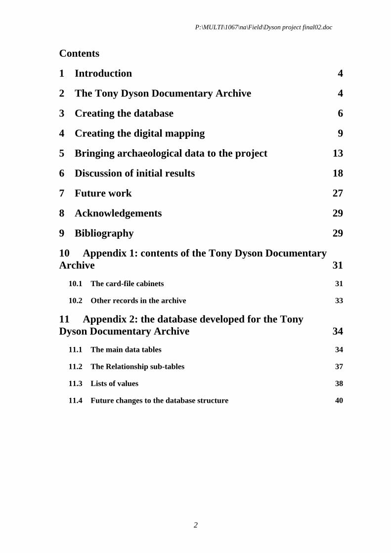
Contents
1 Introduction 4
2 The Tony Dyson Documentary Archive 4
3 Creating the database 6
4 Creating the digital mapping 9
5 Bringing archaeological data to the project 13
6 Discussion of initial results 18
7 Future work 27
8 Acknowledgements 29
9 Bibliography 29
10 Appendix 1: contents of the Tony Dyson Documentary Archive 31
10.1 The card-file cabinets 31
10.2 Other records in the archive 33
11 Appendix 2: the database developed for the Tony Dyson Documentary Archive 34
11.1 The main data tables 34
11.2 The Relationship sub-tables 37
11.3 Lists of values 38
11.4 Future changes to the database structure 40

P:\MULTI\1067\na\Field\Dyson project final02.doc
3
Figures
Fig 1 The structure of the database created for the Tony Dyson Documentary Archive 8 Fig 2 Reconstructed map showing the late medieval/early modern street plan in the five selected parishes, and the medieval tenements 12 Fig 3 Map showing the reconstructed late medieval streets and tenements, with significant archaeological sites superimposed. 16 Fig 4 Plan of the archaeological remains found at the Custom House site (CUS73) and the Three Quays House site (TQH02), shown in relation to the modern Ordnance Survey map 17 Fig 5 Pie charts illustrating the trades practised by owners of three groups of properties along the All Hallows Barking waterfront 25 Fig 6 Plan showing the enhancement of the original ‘best fit’ historic map with data from archaeological excavations and from the Dyson records: a) original reconstruction; b) archaeological evidence added; c) tenements shifted to fit both archaeological evidence and historic measurements; d) revised reconstruction, c 1500 26
Tables
Table 1 Archaeological sites within the five parishes that produced significant topographic information ..............................................................................................14 Table 2 Summary of property history for Tenement W7 in All Hallows Barking........19 Table 3 Summary of descriptive data for tenement W10 in All Hallows Barking .......21 Table 4 Summary of recorded data for the (le) Palmer(e) family ...............................23 Table 5 the recorded prices of the combined tenement AHB W1/W2, with the estimated land value expressed in £ per m² .................................................................24

P:\MULTI\1067\na\Field\Dyson project final02.doc
4
1 Introduction
Tony Dyson joined the newly established Museum of London in 1974, having previously worked at the Guildhall Library. He became Historical Research Officer at the museum’s Department of Urban Archaeology and he continued in this important role until his departure in 1998. He continues to carry out freelance documentary research work for the Museum of London. Beginning in the late 1970s, Tony embarked on an extensive survey of the medieval property records of the parishes along the City waterfront. The Waterfront Project, as it was called, included the 17 waterfront parishes, beginning with St Andrew by the Wardrobe (also called St Andrew Baynard Castle) in the west of the City and continuing as far as All Hallows Barking in the east; see also Dyson 1989 (12–24). Working principally from the Husting Rolls, the records of the medieval Court of Husting, Tony created a card index covering approximately 12,000 medieval transactions.
One of the authors of this report, Nathalie Cohen, was formerly the Archivist at the Museum of London Archaeology Service (where the Tony Dyson Documentary Archive is housed) and wished to enhance this important documentary resource. The City of London Archaeological Trust (COLAT) generously agreed to support a pilot study to look at ways of creating a digital archive based on Tony’s card index. This document reports on that pilot study.
2 The Tony Dyson Documentary Archive
The archive is housed in Archive Section of the Museum of London Archaeology Service. It consists of a number of filing drawers that contain the 12,000 record cards that describe medieval property transactions; the archive is described in detail in Appendix 1 of this report.
The principles behind the analysis of medieval property transactions were developed by the Social and Economic Study of Medieval London, a team who were originally based at the Museum of London, (later at the Centre for Metropolitan History at the University of London) and who were working on a property study of City parishes in the Cheapside area. As Vanessa Harding describes (1985), there are three important factors that allow us to reconstruct medieval London property holdings: firstly, beginning in the second half of the 13th century, deeds and wills recording London property transactions were ‘enrolled’ at the Court of Husting in the Guildhall and consequently some 31,000 transactions have been preserved. Secondly, the form of these property conveyances is remarkably standard and, crucially, each property is identified by its parish, street and neighbouring properties. Thirdly, the size and shape of the medieval properties generally seem to have remained fairly constant during the medieval period, though properties were sometimes joined with neighbours or further subdivided. Tony Dyson worked through these Court of Husting ‘enrolments’ of property transactions and created a record-card summarising each transaction in the 17 waterfront parishes he was studying. Because many of the original Husting Rolls records describe transactions involving the sale of several properties belonging to the same person (with the properties often lying in more than

P:\MULTI\1067\na\Field\Dyson project final02.doc
5
one City parish), Tony created a separate deed record card for each of the distinct properties named in a transaction. Thus the 3000 or so Husting enrolments for the 17 parishes were recorded on 5800 separate record cards. These cards could then be re-arranged in chronological order by parish.
Tony, together with his assistant Colin Taylor, then looked at other sources of property transaction records, ranging from printed calendars of Crown records to unpublished cartularies of monastic and Livery Company records, and he compiled another 5000 or so record cards for these transactions, again arranged in chronological and parish order. Next, the most important stage in the process could be attempted: photocopies of all the record cards (from the Husting Rolls records and the other sources) were collated property by property. It is this series of photocopied record cards, describing c 12,000 individual property transactions, which forms the heart of the Tony Dyson Documentary Archive. It should be noted that at the end of each parish sequence, there is a collection of material that could not be related to individual properties; as more documentary material was collected, unidentified properties were incorporated, however, the process was not completed. The final stage in the process was to use the property descriptions in the records (principally the street ‘addresses’ and the neighbour information) to draw schematic sketch maps of the properties, parish by parish, as a guide to the alphanumeric arrangement of the bundles of records.
P:\MULTI\1067\na\Field\Dyson project final02.doc
6
3 Creating the database
Both Tony Dyson and the Social and Economic Study of Medieval London (SESML) intended to develop their card index records into a database, as computer hardware and software developed in the 1980s. One of the successors to the SESML is a more recent project (also at the Centre for Metropolitan History) called People in Place. This study is building on the SESML work by collating 16th- and 17th-century data from the same five Cheapside parishes to examine the relationship between families, households and housing (Centre for Metropolitan History, 2004). Mia Ridge, a Museum of London database specialist and one of the authors of this report, liaised with Mark Merry from the People in Place project after the MoLAS project structure was originally developed, in order to ensure that our database could be compatible with that of the People in Place project. By this point the MoLAS database design had been through two major design iterations and testing with a project volunteer, so we were able to provide extensive documentation of the database structure and recording methods. This meeting provided external validation for the pilot database design, as both projects had arrived at similar method for recording data.
The database that was developed for our project is described in more detail in Appendix 2. The pilot version of the database used Microsoft Access software but the revised version will use Oracle, the standard system used at MoLAS. Details of the proposed enhancements to the pilot version are detailed in section 11.4. The database has three main data tables that record properties, documents and people (Fig 1). These tables are linked by ‘sub-tables’ that record the relationships and any properties of those relationship between the tables; these relationships can often be quite complex. For example, in the transaction enrolled in the Court of Husting on July 20th 1349 (recorded as document HR 77/49), Thomas son of Adam de Salisbury and his wife Alice granted two properties in the parish of All Hallows Barking (recorded as tenements W2 and A2) on opposite sides of the road now called Thames Street (then called Petty Wales) to John Nott, Peter de Gilnefford and Thomas de Bonwode. To record this transaction in sufficient detail, the document record for Husting Roll 77/49 has to be linked to the two grantors (Thomas de Salisbury and his wife) and the three recipients (Nott, de Gilnefford and de Bonwode). The document record also needs to show that the transaction includes two properties, recorded as AHB W2 and AHB A2. Finally, a separate ‘sub-table’ needs to record the family relationships between Thomas de Salisbury, his father Adam (who once held the property) and his wife Alice.
The main document table can be seen as the core of the database as it records the individual property transactions. This part of the database therefore has fields to record details of the property that are revealed in the transaction. For example, document HR 77/49 names our tenement AHB W2 as ‘the Stonwharf’ (recorded in the property name field), describing it as ‘a capital messuage with a quay (keyum) opposite the same messuage called Stonwharf, with houses built upon the said quay’ (recorded in the property description field). The description of the property’s abutments provides important information on the neighbouring properties and so this data is also recorded. It shows that Adam Turk still occupied the property to the west
P:\MULTI\1067\na\Field\Dyson project final02.doc
7
(AHB A1) in 1349, slightly later than is shown by the ‘direct’ deed evidence for that property.
A sample area for data entry was selected: the 12 waterfront properties of All Hallows Barking in the south-east of the City. The relevant record-cards for these tenements were selected from the card-index files (using the photocopied series of cards arranged in parish and tenement order). There were 150 cards for these properties, beginning in 1278 and continuing in some cases to 1558. These 150 cards were entered using 146 records in the main document table of the database (four of the record cards described transactions of combined adjoining properties that could therefore be recorded using a single record in the document database). These property transactions involved some 262 people, all entered on the main person table of the database. Some of the possible uses of this data are discussed in section 6.

P:\MULTI\1067\na\Field\Dyson project final02.doc
8
Fig 1 The structure of the database created for the Tony Dyson Documentary Archive

P:\MULTI\1067\na\Field\Dyson project final02.doc
9
4 Creating the digital mapping
A sample area for the mapping exercise was selected consisting of the five waterfront parishes to the east of London Bridge: All Hallows, Barking (AHB), St Dunstan in the East (SDE), St Mary at Hill (SMH), St Botolph Billingsgate (SBB) and St Magnus the Martyr (SMM).
The long-term intention is to create a Geographic Information System (GIS) that links the database to map information. An important task of the pilot study was therefore to investigate ways of creating digital mapping. The first decision was to use the modern digital Ordnance Survey (OS) map as a base-map: the advantage of this is that a variety of data sources (historic maps, archaeological data and earlier versions of historic mapping such as Lobel) can be combined on a single accurate grid that covers the whole of London. Experiments were made using scanned versions of Lobel’s historical atlas (1989), of 19th-century Ordnance Survey maps and of Tony Dyson’s original parish sketches but in each case we encountered problems in accurately locating the simple scanned data onto the modern OS grid. We therefore developed a methodology based on creating new digital historic map data, though the concepts behind this approach are broadly based on Johns (1989), who mapped the medieval City for Lobel’s atlas, and on the strategy developed by the Social and Economic Study of Medieval London (Harding 1985). This digital methodology has also been successfully used in a recent project that used computer-based mapping to analyse the area of the medieval Guildhall precinct of London (Bowsher et al, in prep).
Using the modern digital 1:1250 Ordnance Survey (OS) map as a starting point, digital maps of earlier periods were created by map regression using AutoCAD software. The five feet to a mile (1:1056) Ordnance Survey maps of the 1870s were chosen as the principal historic map. These maps are not quite so large-scale as the 1:528 Secondaries’ ward plans of the 1850s (see Harding 1985, 8) but it was decided that they had a sufficient degree of detail and accuracy and that their use would avoid the problems associated with fitting together a large number of individual Secondaries’ ward plans. The Godfrey Edition OS reproductions (published in various sheets during the 1980s) were found to be convenient: the large scale 1:1056 originals are accurately reproduced by Godfrey at 1:1760. The scanned 1875 plan was then fitted to the modern OS national grid by using the ‘scaling’ and ‘aligning’ functions of the software, having defined some common points on both maps (the corners of churches and stations). The 1875 map fitted almost perfectly onto the modern OS map, with discrepancies of the order of 0.5m. Having located the scanned map on the modern grid, the surviving ‘early’ features on the 19th-century OS map, principally the roads, churches and parish boundaries, were digitised (ie, digital outlines were created as ‘layers’ in AutoCAD).
In the next stage, relevant portions of Ogilby and Morgan’s map of 1676 were scanned, using the Margary edition of 1976 (reproduced at the original scale of c 1:1200). The ‘raster’ data of the scanned map (a series of dot or pixel images) was converted into more useful ‘vector’ data by digitising (creating digital outlines of) the main street plan. The digitised main streets, churches and waterfront were approximately located on the modern OS grid using the same methodology (ie by

P:\MULTI\1067\na\Field\Dyson project final02.doc
10
using common points on the 1676 and 1875 maps). The limitations of the Ogilby and Morgan map are discussed in Margary’s introduction (1976) and in Johns (1989). In summary, the lengths of the individual street segments are usually fairly accurate, but the angles and shapes of the ‘blocks’ are not (‘block’ is used here in the American sense meaning an island of built-up urban area between the streets). The digitised streets therefore had to be manually adjusted, working block by block and using the scanned 1875 map as the basis. If a digitised outline of a 1676 block closely matched the shape of the 1875 map, the former was simply moved to match the latter. In cases where the width or layout of the street had clearly been altered, the ‘align’ function of the software was used to achieve a more objective ‘best fit’ using common neighbouring points.
The only accurate map showing London before the Great Fire of 1666 is John Leake’s survey of the ruined City, commissioned by the Mayor and Aldermen after the Great Fire of 1666 and published at a scale of c 1:3600 in 1667 (reproduced in Margary 1981). Though this lacks the detailed accuracy of Ogilby and Morgan’s later map, the Leake survey is the only map to show the pre-Fire road layout and, crucially, the manuscript version has road widths indicated at most of the junctions (BL, add MSS 5415 E1). The next stage, therefore, was to add these road widths onto the digitised 1676 map, in the form of digital circles based on the Leake dimension. The 1676 map could then be manually redrawn to match the Leake survey, taking into account both the reduced road widths and the slightly different street pattern. In addition, it was assumed that the parish boundaries (marked in great detail on the 1875 OS map) were very conservative and that they sometimes indicated details of the pre-Fire street plan: for example, the 1875 parish boundary of All Hallows Barking seems to mark out the ancient, slightly offset, layout of the junction of Tower Street, Mark Lane and Mincing Lane, not the more regular 19th-century layout. In addition, the churches that were not rebuilt after the Great Fire (and which do not therefore appear on the 1676 or 1875 maps) were scaled off the Leake plan and digitally drawn. The street names were also taken from the Leake survey, with some additional names taken from Ogilby and Morgan’s map.
The next stage was to draw the outlines of the properties defined by Tony Dyson. The Dyson archive has a series of sketch plans that schematically show the tenement divisions within the blocks. These plans were drawn by Tony Dyson taking into account all the various property descriptions and in particular the ‘abutment’ relationships specified in the documents he has used (See Dyson 1989, 16–17; Harding 1985, 9–11). The sketches therefore represent a very important ‘best guess’ as to the relative size, shape and abutments of the individual properties. For each street block, a digital outline of each of the ten or so tenements was digitised, using the scanned image of that block on the 1676 map as the basis. An ‘educated guess’ was made as to how the sketched topography of the Dyson map related to the pattern of houses and yards illustrated on the 1676 map: in many cases the shape of the outline sketch could be ‘read into’ the historic map. Each block of digitised tenements based on the 1676 map was then fitted to the digitised 1676 outlines using the ‘align’ function of the software. However, though the 1676 map may give a better impression of the likely pattern of the medieval tenements, the 1875 OS map is likely to have more accurate property boundaries. The digitised pattern based on the Dyson sketch and the 1676 map was therefore adjusted as far as possible to fit the angles and boundaries on the 1875 map (unless that block had been extensively redeveloped in the 18th or 19th century).

P:\MULTI\1067\na\Field\Dyson project final02.doc
11
This methodology works on the assumption that Mills’ and Oliver’s careful surveying of the fire-damaged properties after the great Fire represents a crucial mechanism for continuity between medieval properties and the post-great Fire properties. However, our methodology means that it is very likely that in some cases houses have been included in the wrong tenement, making the outline of one reconstructed medieval tenement too big and its neighbour correspondingly too small. The reconstructed medieval tenements could then be stretched to meet the earlier street frontage (derived from the Leake map) in a reversal of the historical process by which the tenements were trimmed by post-Great Fire road widening.
A number of property transaction documents record the dimensions of the medieval properties and/or the actual houses: the dimensions have been noted by Tony Dyson on the front of the ‘bundle’ of copied record cards for each property. These dimensions were converted into metric and an attempt was made to make the digital map fit the recorded dimensions. In some cases the ‘best fit’ outline closely matched the recorded dimension: property A6 in St Magnus the Martyr was less than one metre out for both its street frontage and its length (and the digital version was duly corrected to match exactly). In other cases, the ‘best fit’ outline had included too many or too few of the houses shown on the 1676 map: in St Botolph parish, the measurements revealed that property E2 had been drawn too wide and that adjacent property E1 had been drawn too narrow (the frontages were therefore altered to fit the documented measurements). In other cases, only one of the documented measurements could be used to correct the original ‘best fit’ version: several of the waterfront tenements in St Mary at Hill have measurements, but these seem to relate to individual buildings that lay within each property. As not all the buildings were described, it was generally only possible to use the east-west property width measurement (property W1, for example). In a few cases, it was not possible to reconcile the measurement, the historic map and Tony Dyson’s sketch (property E4 in St Mary at Hill, for example). In this case (and others) it seemed that the relatively narrow recorded street frontage related to a house within the larger property holding: the original ‘best fit’ property outline was therefore retained unmodified.
The resulting reconstructed map is illustrated on Fig 2. It is essentially a simple map showing the late medieval/early modern street plan; it does not address the question of changing waterfronts, (the map shows medieval tenements but with ‘anachronistic’ 17th century waterfront; the tenements are therefore shorter in the medieval period). The map also does not does attempt to show individual buildings apart from churches (and these are shown in their unedited 1666 or 1875 versions).


P:\MULTI\1067\na\Field\Dyson project final02.doc
13
5 Bringing archaeological data to the project
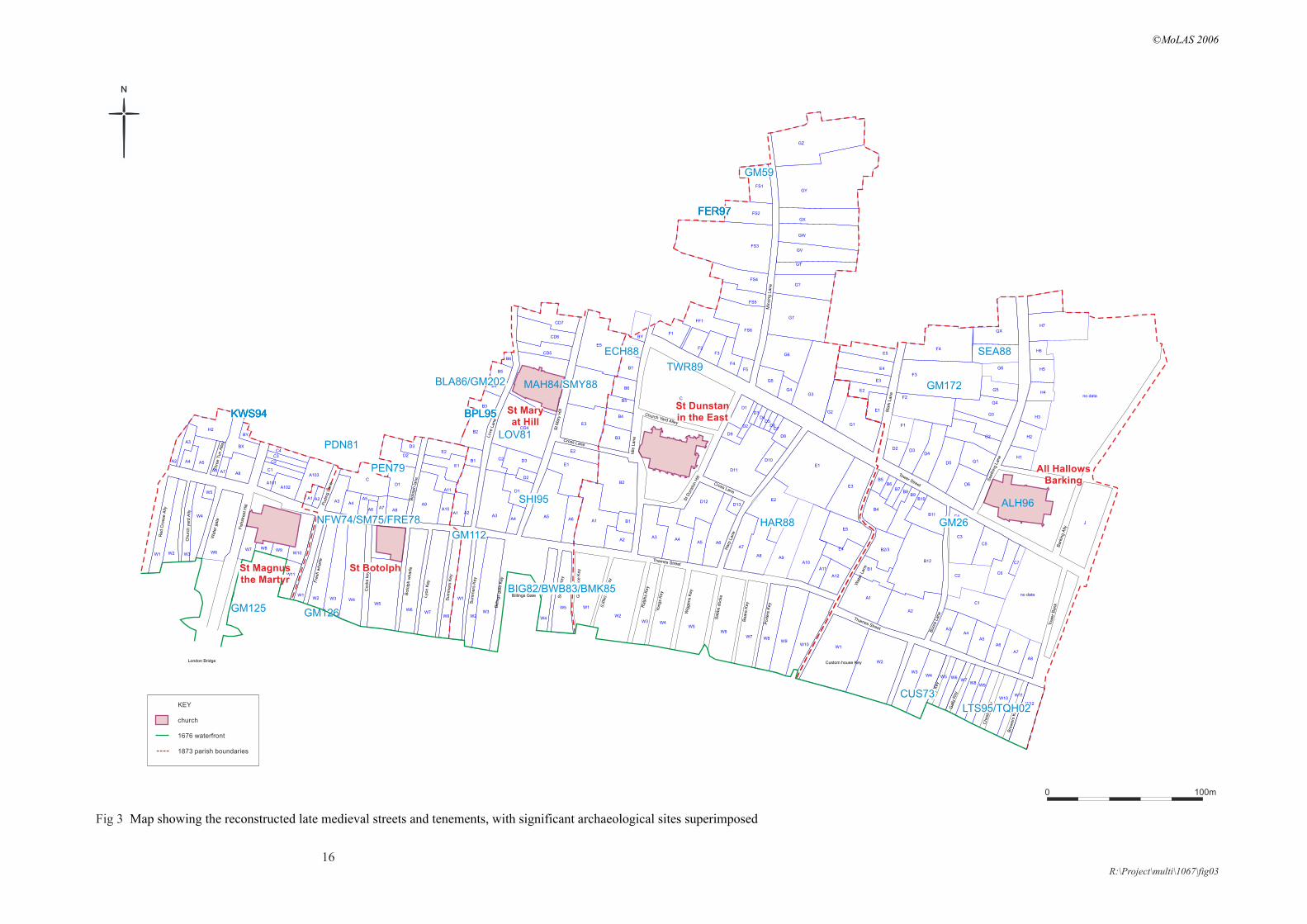
Approximately 60 archaeological sties have been excavated within, or on the edge of, the five parishes selected for this study. These sites will provide accurately located evidence for some of the buildings, quays and streets within the five selected parishes. Published site summaries were checked (Schofield with Maloney 1998; Shepherd 1998, London Archaeologist annual round-ups 1992–2003) in order to concentrate on those sites that have significant medieval (or pre-Great Fire) topographic information: i.e. buildings, walls, waterfronts and roads. This reduced the total number of significant archaeological sites to 26 (Table 1 and Fig 3).
It was decided to look at two sample sites in the south-east of the City in some detail because their locations coincided with the area chosen for the data entry of the documentary records. Three Quays House (TQH02) is a recent excavation that evaluated the site as part of the planning process and which may eventually lead on to further excavation if the site is redeveloped. The site has well organised digital data that is easily accessible. The Custom House site (CUS73) is a much older excavation done by the Museum of London’s predecessor, the Guildhall Museum. Working in difficult circumstances, the team recorded as much surviving archaeological remains as they could in the time available. There is, unsurprisingly, no digital data for this site. The first task was therefore to create a digital outline of the site on the modern OS base map, together with the excavated trenches within it. This process of achieving a ‘best fit’ can often be problematic, particularly since many old sites were surveyed in relation to buildings that are no longer standing and which do not therefore appear on the modern digital map. In this case the site could be located with a reasonable degree of accuracy as the old CUS73 site had been surveyed in relation to the adjacent building, Three Quays House. The relevant archaeological remains, the medieval houses and quays and the post-medieval buildings were then digitised and they are illustrated on Fig 4.
The two sites therefore illustrate the problems in bringing archaeological data to a project such as this. Of the 26 sites in Table 1, only three sites (in addition to TQH02) are recent enough to have digital data that will allow them to be brought into the project with ease. The other 21 sites (in addition to CUS73) only have paper records and would therefore need to be located and digitised in order to be used in this project.

P:\MULTI\1067\na\Field\Dyson project final02.doc
14
Table 1 Archaeological sites within the five parishes that produced significant topographic information
Sitecode Site address Significant topographic features
Simplified bibliographic reference
ALH96 ALL HALLOWS BY THE TOWER, TOWER STREET
church wall site archive
BIG82 NEW FRESH WHARF BILLINGSGATE MARKET, ST MAGNUS
waterfront, lane, buildings, church
Steedman et al 1992 (Aspects SNL III); Schofield & Dyson in prep?; Milne 1992
BLA86 BOTOLPH LANE 36-38 Walls archive report
BPL95 BOTOLPH LANE 30-35, MONUMENT STREET 29-31, EC4
buildings post-excavation assessment report; MoLAS digital site records
BWB83 NEW FRESH WHARF BILLINGSGATE MARKET
waterfront, buildings, churchSteedman et al 1992 (Aspects SNL III); Milne 1992
CUS73 LOWER THAMES ST, CUSTOM HOUSE, SUGAR QUAY
waterfront, buildings LAMAS 1975
ECH88 IDOL LANE 2-4, EASTCHEAP 30-40, ST MARY AT HILL 37
Walls archive report
FER97 GREAT TOWER STREET 53, ROOD LANE 23, FENCHURCH STREET 30-38,
Walls Treveil et al 2003; MoLAS digital site records
HAR88 HARP LANE BT TUNNEL Walls LA 1989
KWS94 REGIS HOUSE Walls MoLAS book; MoLAS digital site records
LOV81 LOVAT LANE 7-28, MARY AT HILL 8-19, BOTOLPHS LANE 29-40,
Walls LAMAS 1983
MAH84 ST MARY AT HILL Church LAMAS 1992
NFW74 /SM75/FRE78
NEW FRESH WHARF BILLINGSGATE MARKET
waterfront, buildings Steedman et al 1992 (Aspects SNL III); Schofield & Dyson in prep?
PDN81 FISH ST HILL, 33-6, KING'S HEAD COURT 2-4, 7-9, PUDDING LANE, 11-11A
buildings archive report
PEN79 LOWER THAMES ST 116, PENINSULAR HOUSE
building LAMAS 1985
SEA88 CORN EXCHANGE CHAMBERS buildings archive report
SHI95 ST MARY AT HILL 19, MONUMENT ST 53, EC3
Wall post-excavation assessment report
TQH02/LTS95 LOWER THAMES STREET, THREE QUAYS HOUSE
revetment Wroe-Brown 2003; MoLAS digital site records
TWR89 GREAT TOWER ST 1-4 buildings archive report
GM112 LOWER THAMES STREET (WEST SIDE OF BILLINGSGATE MARKET), EC3
walls, street Schofield & Dyson in prep
GM172 50 MARK LANE, EC3, building Med Arch 1958
GM126 NEW FRESH WHARF,1-6 LOWER THAMES STREET, EC3
waterfront ('cutwater') Schofield & Dyson in prep; probably integrated in NFW74 publication; best fit in London Bridge pub
GM125 NEW FRESH WHARF,1-6 LOWER THAMES STREET, EC3
waterfront ('cutwater') Schofield & Dyson in prep; probably integrated in NFW74 publication
GM26 26-27 BYWARD STREET, (JUNCTION WITH) WATER LANE, EC3
house (Bakers' Hall) LAMAS 1969

P:\MULTI\1067\na\Field\Dyson project final02.doc
15
GM59 31-34 FENCHURCH STREET, 23 ROOD LANE, 4-8 MINCING LANE, EC3
church (St Margaret Pattens) site archive
GM73 ALL HALLOWS BARKING CHURCH GREAT TOWER STREET, EC3
Church LAMAS 1994
C4
C3
C5
C6
C7
C2
C1
A3A4
A5
A6
A7
A8
J
H1
H2
H3
H4
H5
H6
H7
D2 D3D4
D5
D6
G1
G2
G3
G4
G5
G6
G7
GX
F1
F2
F3
F4
A1
A2
B1
B2/3
B12
B11
B10B9
B8B7
B6B5
B4
W1
W2
W3W4 W5 W6
W7W8
W9
W10W11
W12
E1
E2
E3
E4
E5
W1
W2
W3 W4W5
W6W7 W8
W9W10
A7
A8 A9A10
A11
A12
E4
E5
E3
E1
E2
A3A4
A5 A6
D12D13
D1D3
D4D5
D6D7
D8D9
D10
D11
D2
C
F1
F2F3
F4
F5
FF1
FS1
FS2
FS3
FS4
FS5
FS6
G1
G2
G3G4
G5
G6
G7
G?
GT
GV
GW
GX
GY
GZ
A1
A2
B1
B2
B3
B4
B5
B6
B?
BX
BY
W5
W1
W2W3
W4
A5A6
E1
E2
A1 A2
B1
B2
B3
B4
B5
B6
A3A4
D1
D2
D3C2
CD4
CD5
CD6
CD7
E3
E4
E5
W1W2 W3 W4
W5
W6W7
W8
A3 A4A5
A6 A7A8
D1
D2
D3
C
A9A10
A11
E1
E2
A1 A2
W7 W8 W9W10
W11
W1 W2 W3
W4
W5
W6
A2
A3
A4 A5
A6 A7 A8
H2
BX
BY
A101A102
A103C1
C2
C3
C4
no data
no data
Min
cing L
ane
Idle
Lane
Harp
Lane
Port
ers
Key
Beare
Key
Sabbs
dock
e
Wig
gens
Key
Yongs
Key
Ralp
hs
Key
Sm
art
s K
ey
Billings Gate
Bill
ings
gate
Key
Sum
mers
Key
St M
ary
Hill
Love
Lane
Thames Street
London Bridge
Sum
mers
Key
Lyo
n K
ey
Boto
lph w
harf
e
Cock
s ke
y
Fre
sh w
harf
e
Boto
lph la
ne
Wate
r gate
Churc
h y
ard
Ally
Red C
ross
e A
lly
Bre
wers
Key
Chest
er
Key
Gally
Key
Gally
Key
Custom house Key
Thames Street
Boore
Lane
Tow
er
Bank
Bark
ing A
lly
Seeth
ing L
ane
Tower Street
Wat
er L
ane
Mark
Lane
Fis
hst
reet H
ill Pudin
g L
ane
(Litt
le)
Dic
e K
ey
Gre
at D
ice K
ey
Thre
e T
un A
lley
Cross Lane
Cross Lane
Church Yard Alley
St D
unst
on H
ill
St Magnusthe Martyr
St Botolph
St Maryat Hill
St Dunstanin the East
All HallowsBarking
GM59
GM26
GM125 GM126
GM172
GM112
LTS95/TQH02
FER97FER97
SEA88
FER97
BPL95
FER97
BPL95KWS94KWS94KWS94 BPL95
SHI95
TWR89
HAR88
FER97
BLA86/GM202 MAH84/SMY88
PEN79
ALH96
KWS94
NFW74/SM75/FRE78
BIG82/BWB83/BMK85
ECH88
CUS73
LOV81PDN81
KEY
church
1676 waterfront
1873 parish boundaries
16
Fig 3 Map showing the reconstructed late medieval streets and tenements, with significant archaeological sites superimposed
0 100m
N
R:\Project\multi\1067\fig03
©MoLAS 2006


P:\MULTI\1067\na\Field\Dyson project final02.doc
18
6 Discussion of initial results
The data from the 12 selected properties on the waterfront of All Hallows Barking parish can be looked at in a number of ways. For example, it is easy to create a summary history of a particular tenement, which would be of use to an archaeologist researching an archaeological site, or a historian researching a particular area.
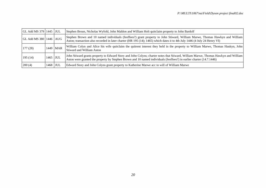
Table 2 illustrates the history of Tenement W7 from its earliest mention in 1316 (and slightly before this as the previous owner is also named) to its latest recorded transaction in 1468. The ownership of the property can be traced as it passes from the Taleworth family in the 14th century and ends up in the hands of William Marwe, who also owned the neighbouring properties (W5 to W8). It can be seen that the annual quitrent of four shillings that was payable on the property was separately ‘traded’ in the mid 14th century. The waterfront property was clearly a desirable one by the 15th century: the Custom House had been built next door in the 14th century (our tenements W1 and 2: see Tatton-Brown et al 1974) and this property was acquired in 1446 by a consortium of important individuals including the grocer William Marwe (soon to be City sheriff and mayor: Barron 2004, 342–3), the chandler John Stiward (later sheriff: ibid) and William Aston (who seems earlier to have been the City undersherriff: ibid, 357). They probably redeveloped the quay facilities and in 1468 the whole block (tenements W5 to W8) was described as Marwes new key (HR 200 (4)).
The data can also be organised to bring together the descriptive data about a particular property in order to look at the topography of a property or area in greater detail. Some of the property descriptions can be formulaic, the ‘messuage with houses’ or ‘tenements with cellars’ for example, but others can be remarkably specific. Taking, for example, tenement AHB W10 (Table 3), the transaction records pay some attention to the private passage within the tenement that allowed access from the road (modern Thames Street, then called Petty Wales) to the actual wharf. A 1383 document (HR 112 (98)) gives very useful measurements of the street frontage on either side of the ‘great stone door’ leading to the passage. These private passages are a typical medieval feature of waterfront properties, distinct from the public lanes of early modern London (Dyson 1989, 18–24).
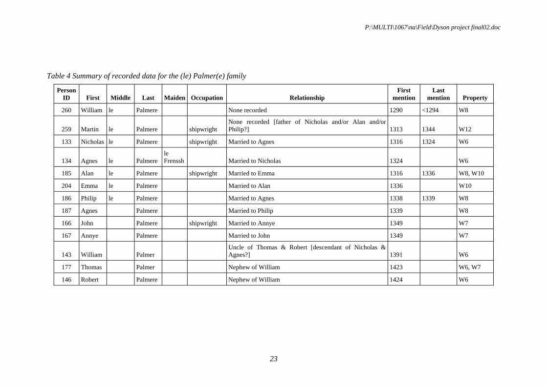
The data can of course be organised by person rather than property and, on a larger scale, this would clearly be of some value for historians of medieval London. For example, from the late 13th to the 15th century the Palmer family had interests in several of the properties along the All Hallows Barking waterfront (Table 4). All the men with named occupations were shipwrights and some of the family relationships and inheritances can be traced or surmised. One interesting point is the gradual simplification of the orthography of the family name, from le Palmere at the end of the 13th century to the modern form Palmer by the end of the 14th century.

P:\MULTI\1067\na\Field\Dyson project final02.doc
19
Table 2 Summary of property history for Tenement W7 in All Hallows Barking
Reference Year Month Comments
45/21 1316 MAY Geoffrey de [Lure?] (illegible in original) and wife Joan granted property to Richard de Taleworth; property once of Beatrix Hartelyn
W65/50 1338 APR William de Talworthe bequeaths property to his wife Gonnora for life, then to daughter Idonen [?] and lawful heirs
65/104 1338 NOV William de Stone and wife Joan quitclaimed property to William de Stamford; notes that Joan inherited property from Richard de Talworth her father
66/59 1339 JUN Gunnora de Braye and John Prest as William son of Richard de Talworth's executors granted property to John son of William Jordan de Reipingham and his wife Alice
W77/133 1349 JAN John Palmere bequeaths his wife Annye the 4s pa quitrent due on William atte Stone's tenement
W77/108 1349 JAN Annye le Palmere bequeaths the 4s pa quitrent on William atte Stone's property to be sold and the proceeds to go to her son Alan
80 (90) 1351 SEP Ralph Campioun as executor of Amicia Palmere sold 4s annual quitrent on property to Sir John Phelip
80 (155) 1352 AUG Adam Gylle and his wife Emma granted property to William Cabelyn of Taleworth and his wife Gunnora; notes that grantors held property by gift and feoffment of Joan atte Stone
82 (46) 1354 JUN William de Spaldyng and Joan his wife granted quitrent on property to Thomas Broun and Margary his wife; notes that Joan inherited property from her cousin Philip Palmere, son of her uncle Alan Palmere
94 (58) 1365 NOV Margary Broun widow of Thomas Broun granted property to Mathew Broun; charter describes how Margary and Thomas had quitrent on property and subsequently acquired fee simple [?] from William Spaldyng and his wife Joan
W97/2 1368 OCT Matthew Broun bequeaths property to Joan his daughter
119 (110) 1391 MAY William Capelyn called Taleworth granted property to Hugh Sprot
GL Add MS 378 1423 MAY grant may include AHB W6 as well as AHB W7; Thomas Palmer granted property to John Bardolf, John Rolf, Robert Marre and William Stonesdale; records that Thomas P inherited property from William Palmer and Hugh Sprot
158 (75) 1425 MAR Thomas Boys quitclaims his interest in property (not exactly defined) to John Bardolf, John Bacoun and John Rolf; grant reiterates Robert Palmere's earlier grant to same three individuals
171 (15) 1442 DEC John Bardolf grants property to Stephen Brown, Nicholas Wyfold, John Maldon and William Holt
P:\MULTI\1067\na\Field\Dyson project final02.doc
20
GL Add MS 379 1445 JUL Stephen Broun, Nicholas Wyfold, John Maldon and William Holt quitclaim property to John Bardolf
GL Add MS 380 1446 AUG Stephen Brown and 10 named individuals (feoffees?) grant property to John Stiward, William Marwe, Thomas Hawkyn and William Aston; transaction also recorded in later charter (HR 195 (14); 1465) which dates it to 4th July 1446 (4 July 24 Henry VI)
177 (28) 1449 MAR William Colyn and Alice his wife quitclaim the quitrent interest they held in the property to William Marwe, Thomas Haukyn, John Stiward and William Aston
195 (14) 1465 JUL John Stiward grants property to Edward Story and John Colyns; charter notes that Stiward, William Marwe, Thomas Hawkyn and William Aston were granted the property by Stephen Brown and 10 named individuals (feoffees?) in earlier charter (14.7.1446)
200 (4) 1468 JUL Edward Story and John Colyns grant property to Katherine Marwe acc to will of William Marwe

P:\MULTI\1067\na\Field\Dyson project final02.doc
21
Table 3 Summary of descriptive data for tenement W10 in All Hallows Barking
Reference Year Location description Property description Value Type
W63/183 1336 12s quitrent
63/201 1336between tenement once of Richard Pylkes to W, that of John Smart to E, Petitwales to N and tenement once of John Stere, Adam's brother (AHB W10b) to S
messuage with houses built thereon and with free entry and exit
78/95 1350between tenement formerly of Richard Pilk on W, that formerly of John Smart on E, that of Thomas Snetesham to N (ie AHB W10a?) and Thames to S
tenements with cellars and solars built above, cum libero introitu et exitu
96 (143) 1368between tenement of Salamon Brounyng on E, that formerly of Thomas Pylk on W, vico regio (Petiwales) to N and Thames on S
tenement cum wharvo adiacente
112 (98) 1383
W10a: houses with solars and cellars on high street (except great stone door with entry to river). Frontage is 11 3/8yds E of door and 7.5yds 2.5in W of door. W10b: all the remnant of the houses and the wharf appartenant. (Gate and passage are shared)
8s quitrent (shared between 2 parties)
123 (104) 1394 in Peti Wales formerly of Thomas de Snetesham called Clerk 8s quitrent
123 (105) 1394
W138 (35)
1397
127 (45) 1399 8s quitrent
127 (50) 1399
127 (42) 1399between tenement of Richard Brounyng on E and that of said John Andrew and the wharfum of the said Margary Brounyng on W, via regia de Pety Wales to N and Thames to S

P:\MULTI\1067\na\Field\Dyson project final02.doc
22
141 (15) 1413 in Petywalys
141 (28) 1413 in Petywalys
144 (13) 1416between tenement lately of Salamon Brounyng now of Robert Purfoot on E, that belonging to Thomas Pylk's chantry at AHB on W, vico regio de Petit Wales to N and Thames to S
lands and tenements with the wharf adjacent and cellars, solars etc
146 (46) 1419
W162 (16)
1433 lands and tenements with the wharf adjacent, cellar, solar etc
169 (35) 1441between tenement of Robert Cony on E, that of a chantry of AHB on W, the viam regiam on N and Thames on S
8s quitrent
W170 (5) 1441between tenement of Robert Cony to E, certain chantry of AHB to W, viam regiam to N and Thames to S
8s quitrent
189 (5) 1460 [is this AHB W10?, or just a part of it?)
197 (14) 1467 Petitwales tenement with wharf adjacent, and (separate?} the dwelling-house (mansionum)
P:\MULTI\1067\na\Field\Dyson project final02.doc
23
Table 4 Summary of recorded data for the (le) Palmer(e) family
Person ID First Middle Last Maiden Occupation Relationship
First mention
Last mention Property
260 William le Palmere None recorded 1290 <1294 W8
259 Martin le Palmere shipwright None recorded [father of Nicholas and/or Alan and/or Philip?] 1313 1344 W12
133 Nicholas le Palmere shipwright Married to Agnes 1316 1324 W6
134 Agnes le Palmere le Frenssh Married to Nicholas 1324 W6
185 Alan le Palmere shipwright Married to Emma 1316 1336 W8, W10
204 Emma le Palmere Married to Alan 1336 W10
186 Philip le Palmere Married to Agnes 1338 1339 W8
187 Agnes Palmere Married to Philip 1339 W8
166 John Palmere shipwright Married to Annye 1349 W7
167 Annye Palmere Married to John 1349 W7
143 William Palmer Uncle of Thomas & Robert [descendant of Nicholas & Agnes?] 1391 W6
177 Thomas Palmer Nephew of William 1423 W6, W7
146 Robert Palmere Nephew of William 1424 W6
P:\MULTI\1067\na\Field\Dyson project final02.doc
24
It will also be possible to look at the types of people who owned property in particular areas because many of the transactions record the trade (or, more accurately, the membership of a trade guild) of the individuals concerned. Using the limited data entered so far as an example, the trades practised by the owners of three groups of properties along the All Hallows Barking waterfront are illustrated as pie charts (Fig 5). The ownership of the Wool Quay/Custom House properties (tenements W1–W4) can be seen to have a different profile from that of the Marwes New Key properties (tenements W5–W8) and the neighbours to the east (W9–W12). In particular, shipwrights can be seen to be dominant in tenements W5 to W12 and this would suggest the practice of that trade in some of those tenements. In the future, this sort of data is best looked at on a larger scale, for example comparing ownership patterns by parish, and perhaps further refining the analysis by concentrating on a shorter time period (say a century) and by excluding non-resident quitrent holders.
The medieval mapping that was created by a ‘best fit’ of the historic maps (section 4) can be enhanced by bringing in both documentary and archaeological data. Fig 6a is a detail of the south-east corner of the City, as it was initially mapped by the best fit of historic map evidence. Fig 6b overlays this plan with the archaeological evidence from the Custom House and Three Quays House sites (for clarity, the site and trench outlines are not shown). On the next detail, Fig 6c, the reconstructed medieval property tenements are shifted to fit both the archaeological evidence (in particular, the medieval Custom House building and the waterfront positions) and the measurements recorded by Tony Dyson in his record cards. The final detail, Fig6d, shows the finished revised ‘best fit’, illustrating the reconstructed tenements and street pattern, c 1500.
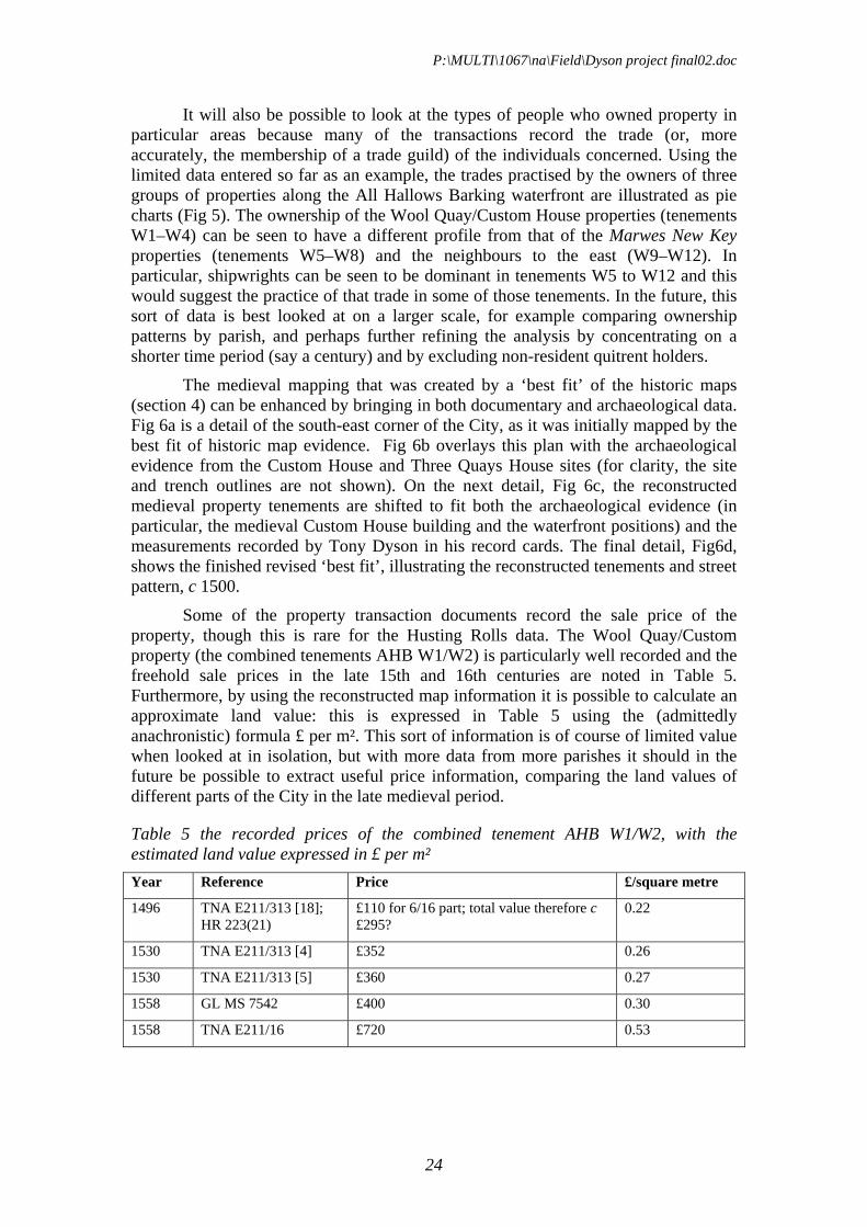
Some of the property transaction documents record the sale price of the property, though this is rare for the Husting Rolls data. The Wool Quay/Custom property (the combined tenements AHB W1/W2) is particularly well recorded and the freehold sale prices in the late 15th and 16th centuries are noted in Table 5. Furthermore, by using the reconstructed map information it is possible to calculate an approximate land value: this is expressed in Table 5 using the (admittedly anachronistic) formula £ per m². This sort of information is of course of limited value when looked at in isolation, but with more data from more parishes it should in the future be possible to extract useful price information, comparing the land values of different parts of the City in the late medieval period.
Table 5 the recorded prices of the combined tenement AHB W1/W2, with the estimated land value expressed in £ per m²
Year Reference Price £/square metre
1496 TNA E211/313 [18]; HR 223(21)
£110 for 6/16 part; total value therefore c £295?
0.22
1530 TNA E211/313 [4] £352 0.26
1530 TNA E211/313 [5] £360 0.27
1558 GL MS 7542 £400 0.30
1558 TNA E211/16 £720 0.53

P:\MULTI\1067\na\Field\Dyson project final02.doc
25
Fig 5 Pie charts illustrating the trades practised by owners of three groups of properties along the All Hallows Barking waterfront
Recorded occupations for tenements W1-W4
mercer
lighterman
grocer
fishmonger
clerk
shipwright
Recorded occupations for tenements W5-W8
cooper
goldsmith
vintner
woodmonger
grocer mercer
shipwright
tapisser
carpenter
chandler
clerk
Recorded occupations for tenements W9-W12
f ishmonger
girdler
goldsmith
grocer ironmonger
mercer
skinner
tailor
vintner
w ool merchant
shipw right
broderer
clerk

C3
C5
J
B2/3
W7 W8W9
A8 A9
E4
E5
Port
ers
Key
Beare
Key
W2W3 W4 W5
W6W7 W8 W9
W10
W11 W12
Port
ers
Key
C4
C3
C5
C6
C7
C2
J
B1
B2/3
B12
W7 W8W9
A8 A9A10
A11
A12
E4
E5
no data
W2W3 W4 W5
W6W7 W8 W9
W10
W11 W12
5.5 ells
7.5 yards, 2.5 inches
11 3/8 yards
line of c 1500waterfrontestimated
C1
A3A4
A5
A6
A7
A8
A1
A2
W1 W2
W3
W4W5 W6
W7W8
W9 W10
W11
W12
W9W10
no data
Chest
er
Key
Gally
Key
Gally
Key
Custom house Key
Thames Street
Boore
Lane
Tow
er
Bank
Wat
er L
ane
1700 waterfront
1600 waterfront
14th-century waterfront
?13th-century waterfront
‘early’ medievalquay front
17th-centurycellars
14th-centuryCustom House
C4
C3
C5
C6
C7
C2
C1
A3A4
A5
A6
A7
A8
J
A1
A2
B1
B2/3
B12
B11
B10B9
B8
B4
W1 W2
W3
W4W5 W6
W7W8
W9 W10
W11
W12
W6W7 W8
W9W10
A7
A8 A9A10
A11
A12
E4
E5
E2
A6
D13
no data
Harp
Lane
Port
ers
Key
Beare
Key
Sabbs
dock
e
Chest
er
Key
Gally
Key
Gally
Key
Custom house Key
Thames Street
Boore
Lane
Tow
er
Bank
Bark
ing A
lly
Wat
er L
ane
Cross Lane
26
Fig 6 Plan showing the enhancement of the original ‘best fit’ historic map with data from archaeological excavations and from the Dyson records: a) original reconstruction; b) archaeological evidence added; c) tenements shifted to fit both archaeological evidence and historic measurements; d) revised reconstruction, c 1500
N N
A
C
B
D
N N
0 50m 0 50m
0 50m 0 50m
R:\Project\multi\1067\fig06
©MoLAS 2006

P:\MULTI\1067\na\Field\Dyson project final02.doc
29
8 Acknowledgements
The pilot study was generously funded by a grant from the City of London Archaeological Trust. Mia Ridge performed the requirements analysis and designed the database, and Nick Holder undertook the data entry and digital mapping. Jane Dunn produced the graphics. Louise Mitchell (Bradford University placement student) compiled the index to the archive (Appendix 1) and Charlotte Veysey (University College London placement student) undertook initial user testing of the database. Mark Burch and Duncan Lees (MoLAS Geomatics) lent their considerable experience to the mapping element of the project. The authors would also like to thank Gustav Milne (Institute of Archaeology, UCL), Pete Rauxloh (MoL) and Pete Rowsome (MoLAS) for guidance and support. From the Centre for Metropolitan History, Professors Derek Keene and Matthew Davies, together with Mark Merry are thanked for their time and information. The project was managed by Nathalie Cohen.
9 Bibliography
Bowsher, D, and Holder, N, with Dyson, T, and Howell, I, in prep The London Guildhall: the archaeology and history of the Guildhall precinct from the early medieval period to the 20th century, London
Carlin, M, 1983 The Urban development of Southwark, c. 1200 to 1550, University of Toronto, unpub Ph.D. dissertation
Carlin, M, 1987 Historical gazetteer of London before the Great Fire, II, the parishes of St. Botolph Aldgate (Minories, east side) and Holy Trinity Minories, (general ed, D. Keene), unpub typescript, Institute for Historical Research, London
Centre for Metropolitan History, 2004 People in place: families, households and housing in early modern London, in Centre for Metropolitan History Annual Report 2003–4, University of London, 13–16
Dyson, T, 1989 Documents and archaeology. The medieval London waterfront (annual archaeology lecture series, Museum of London, 1987), Museum of London
Godfrey 1987 [various sheets of the reproduction 19th-century Ordnance Survey maps]
Harding, V, 1985 Reconstructing London before the Great Fire, in London Topographical Record, vol 25, 1–12
Johns, H, 1989 Introduction to the maps, in Lobel 1989, 57–62
Lobel, M (ed), 1989 The City of London from prehistoric times to c 1520, The British atlas of historic towns, vol 3, Oxford
Margary, H, 1976 A large and accurate map of the City of London [Ogilby and Morgan’s map of 1676], Kent and London (Harry Margary in association with the Guildhall Library)
Margary, H, 1981 A collection of early maps of London 1553–1667, Kent and London (Harry Margary in association with the Guildhall Library)

P:\MULTI\1067\na\Field\Dyson project final02.doc
30
Schofield, J 1993 The Building of London: from the Conquest to the Great Fire British Museum Press (with the Museum of London)
Schofield, J with Maloney, C 1998 Archaeology in the City of London 1907–91: a guide to records of excavations by the Museum of London, London
Shepherd, J, 1998 Post-war archaeology in the City of London 1946–72: a guide to records of excavations by Professor W F Grimes held by the Museum of London, London
Treveil, P, with Dunwoodie, L, Harward, C and Pitt, K, 2003 Plantation Place, London EC3. An archaeological post-excavation assessment and updated project design, unpub MoLAS report
Townsend, S, Chappell, C, and Struijve, O, 1999 Digitising history: a guide to creating digital resources from historical documents Oxbow Books
Wroe-Brown, R, 2003 Three Quays House, Lower Thames Street, London EC3. An archaeological evaluation and revised impact assessment report, unpub MoLAS report

P:\MULTI\1067\na\Field\Dyson project final02.doc
31
10 Appendix 1: contents of the Tony Dyson Documentary Archive
The archive is housed in the Museum of London Archaeology Service’s archive in Mortimer Wheeler House at 46 Eagle Wharf Road, London, N1 7ED. It consists of five pairs of green card-file cabinets (labelled A-H), eleven pairs of grey card-file cabinets (K-DD), three boxes (1-3), three folders, one A4 paper wallet, three rolls of plans and some files in a filing cabinet.
The archive consists of a sequence of record-cards that describe individual medieval property transactions. It consists of approximately 2000 cards recording property transactions from published sources (drawers C to D, see below), c 5800 cards describing the transactions ‘enrolled’ in the Husting Rolls (drawers I to N) and c 3100 cards from Livery Company records and other sources (drawers Q to T), making a total of c 11,000 records. These records were then photocopied (and if a card described more than one property multiple copies were made) and arranged in bundles, property by property. This second sequence (drawers U to DD) contains c 12,000 photocopied cards.
The records are filed by parish, running from west to east and using the following codes:
SABC St Andrew Baynard Castle SBPW St Benet Paul’s Wharf SPL St Peter the Less SMS St Mary Somerset SMQ St Michael Queenhithe SJG St James Garlickhithe SMV St Martin Vintry AHG All Hallows the Great AHL All Hallows the Less SLP St Lawrence Pountney SMO St Martin Orgar SMCL St Michael Crooked Lane SMM St Magnus Martyr SBB St Botolph Billingsgate SMH St Mary at Hill SDE St Dunstan in the East AHB All Hallows Barking
10.1 The card-file cabinets
• A- Index of Husting Rolls, arranged by roll no. • B- Index of bibliographical references • C- Sources Covered (including To be Seen, Early Inhabitants [by parish],
Ecclesiastical Property Holders, Extra Mural, Unlocated [property transactions in published sources], General. A sequence of property transaction records deriving
P:\MULTI\1067\na\Field\Dyson project final02.doc
32
from published sources then begins in parish order (SABC-AHL) and continues in the following drawer.
• D- SLP-AHB • E- This drawer and the next contains a sequence of Tony’s ‘first draft’ Husting
Roll record-cards in parish order, SABC-SDE • F- AHB then unidentified. • G- Blank Index Cards. • H- Blank Dividers. Drawers I-N contain the main sequence of record-cards that record the Husting Roll ‘enrolments’, rearranged in chronological order by parish. . • I- SABC- SMQ • J- SJG- AHG • K- AHL- SMO • L- SMCL- SBB • M- SBB- SDE (to 1387) • N- SDE (from 1387)- AHB • O- This drawer and the next contain duplicate cards, arranged in the original
Husting Roll sequence. Enrolments 1-80 • P- Husting Enrolments 81–90 • Q- property records of Livery Companies A-N • R- Livery Companies O-Z • S- property records from The National Archive (the former PRO) and St Paul’s
Deeds • T- property records from cartularies The following drawers (U-DD) contain the most important records of the archive: the photocopies of the material in drawers C–D, I–N and Q–T rearranged in tenement order, by Parish. • U- SABC-SPL • V- SMS- SMQ • W- SJG- SMV • X- AHG- AHL • Y- SLP- SMCL • Z- SMCL- SMM • AA- SBB • BB- SMH • CC- SDE • DD- AHB

P:\MULTI\1067\na\Field\Dyson project final02.doc
33
10.2 Other records in the archive
10.2.1 Grey archive boxes containing:
1. Hustings Enrolments for St Mary Alder Mary, St Mildred Bread Street and All Hallows Bread Street.
2. Information on Milk Street. 3. Hustings Enrolments for Baynard Castle.
10.2.2 Folders:
One blue folder, containing information about the organisation of the archive. Two black folders, containing indexes. One yellow A4 wallet, containing some notebooks.
10.2.3 Filing Cabinet
A series of folders filed alphabetically by site/area/project etc, according to Tony’s original notes. Baynard Castle Botolph Wharf Cheapside Clothworkers Company Christ’s Hospital (GPO site) Drapers Company Fleet Valley Early Harbour Regulations Greyfriars Leadenhall London Bridge Milk Street Misc. Moorgate/ Bishopsgate Old Broad Street PRO St Bartholomew’s St Mary Aldermary Sources- St Thomas Acon St Thomas’ Hospital Skinners Company Tower Postern Witling Court Westminster
10.2.4 Plans
One labelled Thames Street, one labelled Lilbourn 1676 and one unlabelled with levels.

P:\MULTI\1067\na\Field\Dyson project final02.doc
34
11 Appendix 2: the database developed for the Tony Dyson Documentary Archive
The design of the database application was guided by an analysis of the source data and the requirements to enable:
• Realistic and efficient data entry processes • Variation between level of detail in, and scope of, common data elements • Precise search and detailed analysis of data • Retention of the integrity of the original data • The meaningful reconstitution of data in reports.
This section details the results of the initial requirements analysis. The assumptions made are subject to change based on the outcome of the pilot stage.
11.1 The main data tables
11.1.1 Document table
Notes: As each document only contains one transaction, the 'document' object is implicitly a 'transaction' object. That is, it has been assumed that there is a 1:1 relationship between documents and transactions - each document records only one transaction, and each transaction is recorded on only one document.
Importantly, this enables compatibility with other applications recording historic data, as the information recorded relates to the transaction or event, rather than to the format or properties of the document itself.
Information about the property that might change over time, such as the name, description, value, type or purpose, and other details should be recorded with the document. It will always be retrievable for any given property but allows for each property to have different information over time. Information to do with the transaction itself, such as rent days, prices, contract details, etc, should also be recorded with the document as each document record is implicitly a transaction record. Original documents can be derived from references. Reference numbers may be from the Public Records Office, Hustings Rolls, Parish Register, etc.
The decision was made not to include the legal terminology of the contract, as the project is intended to be a reference to the original documents, not a complete replica. Researchers can use it as a starting point and refer to the source documents. The purpose of a property is not recorded separately as it can be included in the general description if known. It was also decided not to record the witnesses, as the information does not directly relate to the property itself (and it would significantly slow data entry).
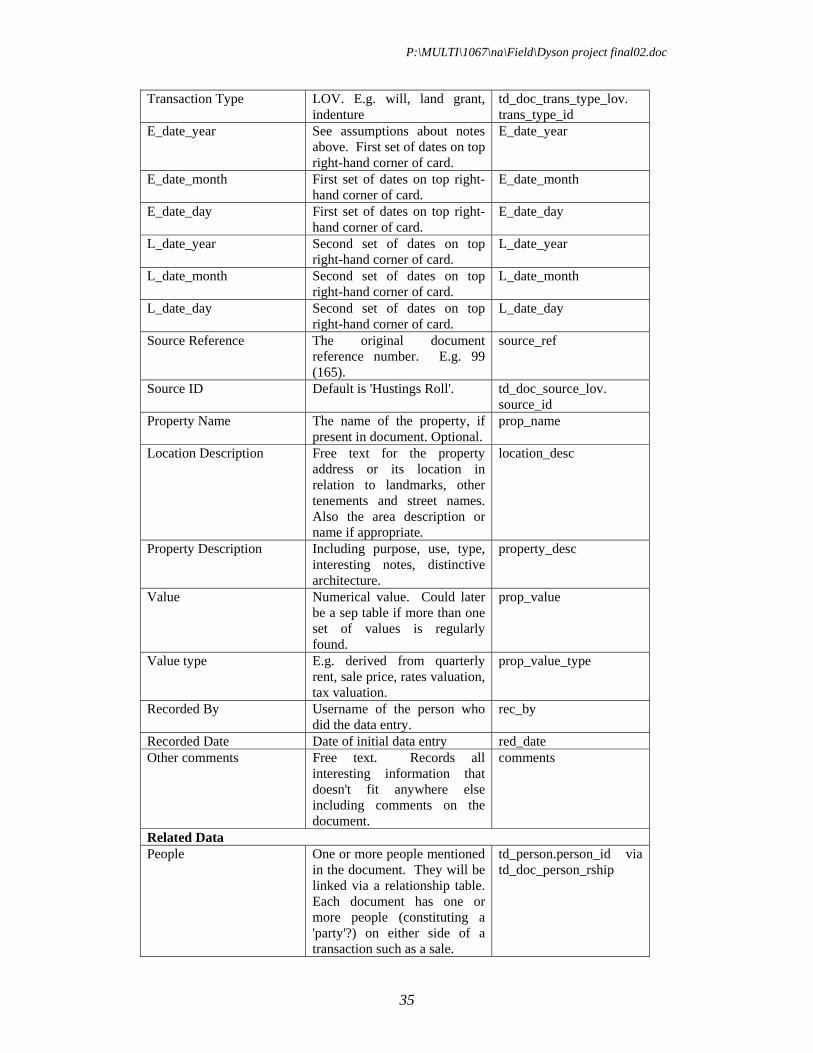
Table name: td_document Item Description Database field Document ID Automatically generated
unique number doc_id
P:\MULTI\1067\na\Field\Dyson project final02.doc
35
Transaction Type LOV. E.g. will, land grant, indenture
td_doc_trans_type_lov. trans_type_id
E_date_year See assumptions about notes above. First set of dates on top right-hand corner of card.
E_date_year
E_date_month First set of dates on top right-hand corner of card.
E_date_month
E_date_day First set of dates on top right-hand corner of card.
E_date_day
L_date_year Second set of dates on top right-hand corner of card.
L_date_year
L_date_month Second set of dates on top right-hand corner of card.
L_date_month
L_date_day Second set of dates on top right-hand corner of card.
L_date_day
Source Reference The original document reference number. E.g. 99 (165).
source_ref
Source ID Default is 'Hustings Roll'. td_doc_source_lov. source_id
Property Name The name of the property, if present in document. Optional.
prop_name
Location Description Free text for the property address or its location in relation to landmarks, other tenements and street names. Also the area description or name if appropriate.
location_desc
Property Description Including purpose, use, type, interesting notes, distinctive architecture.
property_desc
Value Numerical value. Could later be a sep table if more than one set of values is regularly found.
prop_value
Value type E.g. derived from quarterly rent, sale price, rates valuation, tax valuation.
prop_value_type
Recorded By Username of the person who did the data entry.
rec_by
Recorded Date Date of initial data entry red_date Other comments Free text. Records all
interesting information that doesn't fit anywhere else including comments on the document.
comments
Related Data People One or more people mentioned
in the document. They will be linked via a relationship table. Each document has one or more people (constituting a 'party'?) on either side of a transaction such as a sale.
td_person.person_id via td_doc_person_rship

P:\MULTI\1067\na\Field\Dyson project final02.doc
36
Properties They will be linked via a relationship table.
td_property.property_id via td_doc_prop_rship
11.1.2 People table
Notes: varying levels of information will be present for people so the structure has to allow for this. Witnesses aren't currently recorded as testing with a volunteer found that the effort required to record them won't be commensurate with the eventual use. There doesn't seem to be enough information to record the address of an individual unless it's explicitly mentioned in a transaction, in which case it will exist in the Properties table. A general description e.g. 'of London' is often present and should be recorded as free text. A disadvantage of this approach is that spelling errors or variations might be entered.
Table name: td_person Item Description Database field Person ID Automatically generated unique
number person_id
First name If present. Initials or abbreviations ok. first_name Middle names If present. Initials or abbreviations ok. middle_names Last name Minimum required information last_name Maiden name If present. maiden_name Sex Male/Female/Unknown. Also degree
of certainty? Format to be decided. sex
Year of birth Can be derived from DOB or age at time of document
DOB_year
Month of birth DOB_month Day of birth Calendar day of birth. DOB_day DOB certainty Was the DOB information given in the
document, derived from the person's age at the time of the document, unknown or other?
DOB_certainty
Title(s) Honourific etc. title Occupation ('citizen and merchant'): LOV td_occupation_lov.occ_id Address Free text to allow for varying levels of
detail
Description Any other interesting information about the person
descrip
Related Data Relationships Non-transactional relationships (e.g.
family or marital), linked via a relationship table.
td_person_person_rship
Documents They will be linked via a relationship table.
td_doc_person_rship
11.1.3 Property table
Notes: will need surrogate primary key (i.e. automatically generated ID numbers) because the nature of the data doesn't lend itself to absolute uniqueness. A tenement might appear in several documents. It was assumed that properties can be divided, combined and reconfigured over different transactions. This will have implications for searching for existing properties when entering data or when using data later.

P:\MULTI\1067\na\Field\Dyson project final02.doc
37
Therefore, parish and tenement is probably the best fundamental block for linking properties for searches or data entry. The parish, tenement, etc can be re-combined to produce a near-unique reference for a tenement. E.g. AHB H2(b). It has been assumed that it is better to enter information such as related streets and landmarks, and general area description or name (e.g. 'Wool Wharf') as free text.
Table name: td_property Item Description Database field Property id Automatically generated unique
number prop_id
Parish LOV. Compulsory. parish Tenement Letter. Compulsory? tenement Sub-tenement Number. Optional. subtenement Sub-sub-tenement Letter in brackets. Optional. subsubtenement Easting Taken from centroid. easting Northing Taken from centroid. northing Related Data Documents td_document via
td_doc_prop_rship Parishes td_parish_lov Maps td_map
11.2 The Relationship sub-tables
Relationships link objects (documents, properties, people) together. The relationships have been designed for greatest flexibility. For example, separating Documents-People and Documents-Properties allows more than two people per transaction. Relationships can be entered directly or derived from other relationships. The directly recorded relationships will be:
Documents - Properties Documents - People Documents - Maps People - People We could have a relationships table to record the cross-references between the various documents, eg HR77/45 citing the earlier document 77/12.
11.2.1 Documents-Properties
Table name: td_doc_prop_rship Item Description Database field Property ID prop_id Document ID doc_id
11.2.2 Documents-People
Notes: types of roles are recorded in the transaction types LOV. Each transaction type is considered to have two related roles, on either side of the transaction. These roles

P:\MULTI\1067\na\Field\Dyson project final02.doc
38
are arbitrarily designated 'a' or 'b'. If further roles are required for transactions, the transaction types LOV structure can be expanded to allow for these, and types 'c', 'd', etc, allowed in the td_doc_person_rship table.
Table name: td_doc_person_rship Item Description Database field Document ID doc_id Person ID person_id Role Side 'a', 'b', etc. See below for roles
LOV. role
11.2.3 People-People
Notes: should allow family tree to be derived. While some relationships between people are implicit in transactions, this table is for relationships such as husband and wife, offspring or siblings that aren't dependent on transactions. The only relationships that should be defined in this table are pre-existing, non-transactional relationships. In plain English, this means relationships that don't only exist because of a transaction such as a sale or lease, relationships such as marriage, parentage, or business partnerships. Both parents for a child should be recorded where possible, to allow for multiple marriages and other complicated human relationships. Relationships are entered as 'person a to person b', for example, Person A married Person B, or Person A parented Person B.
Table name: td_person_person_rship Item Description Database field Relationship ID p_p_rship_id Person ID First party person_id_a Person ID Second party person_id_b Relationship type
LOV, see below. rship_id
start_date start_date end_date end_date recorded_date Date of earliest document that
mentions the relationship. recorded_date
11.3 Lists of values
Lists of values (LOVs) generally consist of an automatic ID and the value (name) for each type. There are currently six LOVs: parishes, occupations, relationship types, document sources, transaction types and application users.
11.3.1 Parishes
The 17 waterfront parishes represented in the archive, see list and codes above (section 10)

P:\MULTI\1067\na\Field\Dyson project final02.doc
39
11.3.2 Occupations
Table name: td_occupation_lov Item Description Database field Occupation ID Automatically generated unique
number. Compulsory. occ_id
Exp (name) Compulsory. Title of occupation. exp Comment Any comments or description on the
occupation. descrip
11.3.3 Relationship Types
Notes: lists types of relationships that can't be explicitly derived from transactions. For example, married couples are listed in the same transaction but their marriage isn't part of the transaction so this can't be looked up. Generally, the relationship types will be family or marital.
Table name: td_relationship_lov Item Description Database field Relationship ID
Automatically generated unique number. Compulsory.
rship_id
Exp (name) E.g. married, parented. Compulsory. exp Comment Any comments or description on the
relationship type. descrip
11.3.4 Document Sources
Notes: lists the source of the document, for example Husting Rolls or Parish Register. Table name: td_doc_source_lov Item Description Database field Source ID Automatically generated unique
number. Compulsory.
Exp (name) Compulsory. exp Comment Any comments or description on the
source. descrip
11.3.5 Transaction Type
Notes: records the type of document or transaction. For example, sale, lease, or will. Each transaction type is considered to have two related roles, on either side of the transaction. These roles are arbitrarily designated 'a' or 'b'. If further roles are required for transactions, the transaction types LOV structure can be expanded to allow for these, and types 'c', 'd', etc, allowed in the td_doc_person_rship table.
Table name: td_doc_trans_type_lov Item Description Database field Transaction Type ID
Automatically generated unique number. Compulsory.
trans_type_id
Exp (name) Compulsory. Title of the transaction. exp

P:\MULTI\1067\na\Field\Dyson project final02.doc
40
Comment Any comments or description of the transaction type. E.g. sale
descrip
Role a A user-friendly description of the role. E.g. seller
side_a_exp
Side b A user-friendly description of the role. E.g. buyer
side_b_exp
11.3.6 Application Users
Notes: lists people doing data entry. Table name: td_doc_source_lov Item Description Database field Source ID Automatically generated unique
number. Compulsory.
Exp (name) Compulsory. Usually initials or Oracle user name or similar.
exp
Description Full name descrip
11.4 Future changes to the database structure
The main structural improvement to the database will be to enable meaningful integration with the People in Place database, as well as minor modifications to the MoLAS database structures to incorporate the outcome of the pilot. Detailed analysis would be required to determine structural and semantic compatibility with the People in Place database and to support requirements discovered during the pilot data entry and initial results production.
Possible improvements include: Increased transaction detail: enhancing the level of detail of the actual property
transaction in the main document form/table. We intend to revise the structure of the document>person relationship subform to have a person A, their role, a person B, their role and an optional person C (ie an executor/feoffee). Witnesses may also be recorded.
Location description and topographical data: the location descriptions for a property contain important chronological and person information about the neighbouring properties. In addition to having a free text box, we should be able to record properties on the north, east, west and south sides of the property being described. We should also be able to record information about persons on adjacent properties and whether they were a former or current occupant, owner, etc. The key point about this is that when a report for a property is created, it could include this additional ‘peripheral’ information in addition to the directly entered data.
Related former person: for example, a former occupant field is also needed in the main part of the document form. The peripheral information is often the only time a particular occupant is named, and it can also give extra information on how long someone held a property. This would be particularly useful for the first document in a chronological series (the early Husting Roll documents often name previous owners, thereby extending the data back into the middle of the 13th century; in later documents there are also references to former owners who don’t otherwise appear).

P:\MULTI\1067\na\Field\Dyson project final02.doc
41
Occupancy: recording whether named parties related to a property are occupants of the property described.
Recorded property dimensions: analysis is required to determine whether it would be useful to record this information in the database. If so, can the difference between the stated dimensions and the dimensions after fitting to the map be derived from the mapping information? Or given that sometimes the measurements seem to relate to buildings within a larger property holding, is it best just to record them as records of the originally stated dimensions without linking it to the modern mapping?
Property value and property value type fields: it will be necessary to define a list of values for the property value box in the document form, perhaps with a drop-down menu of types: sale price, lease price, annual rent, annual quitrent. This might need to be split into transaction value and property value, depending on the data available.
More person detail: for example, it seems that it would be worth recording membership of guilds as they are a guide to occupation and other indicators of trade or status. The type of evidence for occupation or status should be recorded as well as whether it is stated directly or indirectly. Also, the pilot shows that a surname prefix is required, and that the 'middle name' field might need to be re-labelled. It would also be interesting to look at the possibilities for deriving relationships or recording variations in family names over time, based on existing models.
External references: to properties and persons in other data sources such as documentary or archaeological evidence.
Mapping: the original database had a map form but since the link to mapping will be via a GIS map (containing polygons named by the parish and tenement number, eg AHB W10) there will no longer need to have a separate form/table for map information.