The Tampa Center City Plan
136
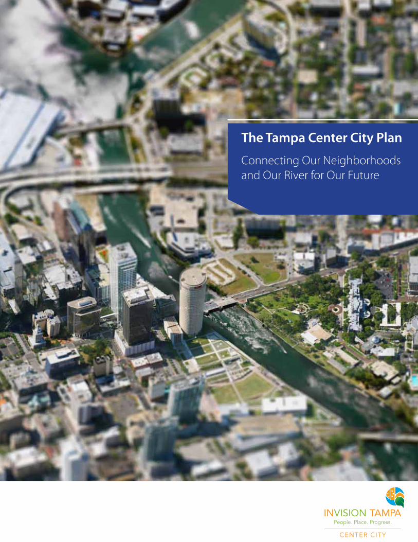
The Tampa Center City Plan Connecting Our Neighborhoods and Our River for Our Future
Transcript of The Tampa Center City Plan
The Tampa Center City Plan
Connecting Our Neighborhoods and Our River for Our Future

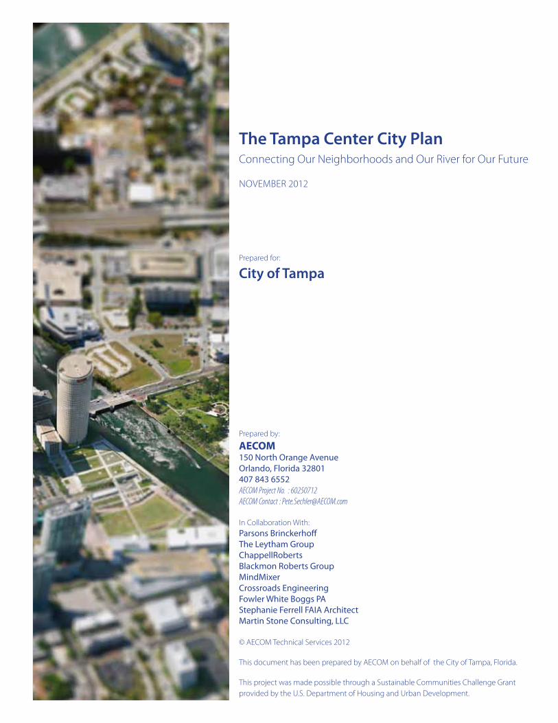
IMAGE PLACEHOLDER
The Tampa Center City PlanConnecting Our Neighborhoods and Our River for Our Future
NOvembeR 2012
Prepared for:
City of Tampa
Prepared by:
AECOM150 North Orange AvenueOrlando, Florida 32801407 843 6552AECOM Project No. : 60250712AECOM Contact : [email protected]
In Collaboration With:Parsons BrinckerhoffThe Leytham GroupChappellRobertsBlackmon Roberts GroupMindMixerCrossroads EngineeringFowler White Boggs PAStephanie Ferrell FAIA ArchitectMartin Stone Consulting, LLC
© AeCOm Technical Services 2012
This document has been prepared by AeCOm on behalf of the City of Tampa, Florida.
This project was made possible through a Sustainable Communities Challenge Grant provided by the U.S. Department of Housing and Urban Development.
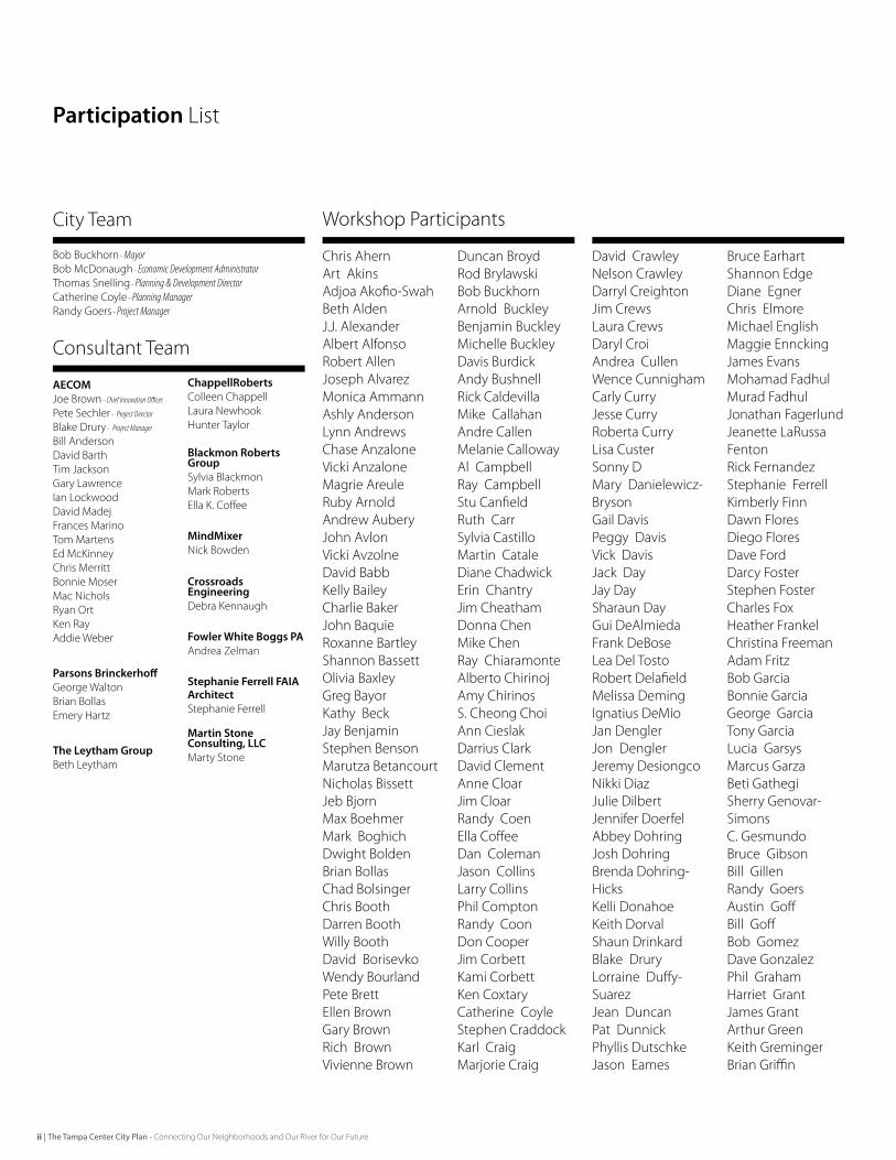
Participation List
AECOMJoe brown - Chief Innovation Officer
Pete Sechler - Project Director
blake Drury - Project Manager
bill AndersonDavid barthTim JacksonGary LawrenceIan LockwoodDavid madejFrances marinoTom martensed mcKinneyChris merrittbonnie mosermac NicholsRyan OrtKen RayAddie Weber
Parsons BrinckerhoffGeorge Waltonbrian bollasemery Hartz
The Leytham Groupbeth Leytham
ChappellRobertsColleen ChappellLaura Newhook Hunter Taylor
Blackmon Roberts GroupSylvia blackmonmark Robertsella K. Coffee
MindMixerNick bowden
Crossroads EngineeringDebra Kennaugh
Fowler White Boggs PAAndrea Zelman
Stephanie Ferrell FAIA ArchitectStephanie Ferrell
Martin Stone Consulting, LLCmarty Stone
bob buckhorn - Mayorbob mcDonaugh - Economic Development AdministratorThomas Snelling - Planning & Development Director Catherine Coyle - Planning Manager Randy Goers - Project Manager
Chris AhernArt AkinsAdjoa Akofio-Swahbeth AldenJ.J. AlexanderAlbert AlfonsoRobert AllenJoseph Alvarezmonica AmmannAshly AndersonLynn AndrewsChase Anzalonevicki Anzalonemagrie AreuleRuby ArnoldAndrew AuberyJohn Avlonvicki AvzolneDavid babbKelly baileyCharlie bakerJohn baquieRoxanne bartleyShannon bassettOlivia baxleyGreg bayorKathy beckJay benjaminStephen bensonmarutza betancourtNicholas bissettJeb bjornmax boehmermark boghichDwight boldenbrian bollasChad bolsingerChris boothDarren boothWilly boothDavid borisevkoWendy bourlandPete brettellen brownGary brownRich brownvivienne brown
Duncan broydRod brylawskibob buckhornArnold buckleybenjamin buckleymichelle buckleyDavis burdickAndy bushnellRick Caldevillamike CallahanAndre Callenmelanie CallowayAl CampbellRay CampbellStu CanfieldRuth CarrSylvia Castillomartin CataleDiane Chadwickerin ChantryJim CheathamDonna Chenmike ChenRay ChiaramonteAlberto ChirinojAmy ChirinosS. Cheong ChoiAnn CieslakDarrius ClarkDavid ClementAnne CloarJim CloarRandy Coenella CoffeeDan ColemanJason CollinsLarry CollinsPhil ComptonRandy CoonDon CooperJim CorbettKami CorbettKen CoxtaryCatherine CoyleStephen CraddockKarl Craigmarjorie Craig
David CrawleyNelson CrawleyDarryl CreightonJim CrewsLaura CrewsDaryl CroiAndrea CullenWence CunnighamCarly CurryJesse CurryRoberta CurryLisa CusterSonny Dmary Danielewicz-brysonGail DavisPeggy Davisvick DavisJack DayJay DaySharaun DayGui DeAlmiedaFrank DeboseLea Del TostoRobert Delafieldmelissa DemingIgnatius DemioJan DenglerJon DenglerJeremy DesiongcoNikki DiazJulie DilbertJennifer DoerfelAbbey DohringJosh Dohringbrenda Dohring-HicksKelli DonahoeKeith DorvalShaun Drinkardblake DruryLorraine Duffy-SuarezJean DuncanPat DunnickPhyllis DutschkeJason eames
bruce earhartShannon edgeDiane egnerChris elmoremichael englishmaggie ennckingJames evansmohamad Fadhulmurad FadhulJonathan FagerlundJeanette LaRussa FentonRick FernandezStephanie FerrellKimberly FinnDawn FloresDiego FloresDave FordDarcy FosterStephen FosterCharles FoxHeather FrankelChristina FreemanAdam Fritzbob Garciabonnie GarciaGeorge GarciaTony GarciaLucia Garsysmarcus Garzabeti GathegiSherry Genovar-SimonsC. Gesmundobruce Gibsonbill GillenRandy GoersAustin Goffbill Goffbob GomezDave GonzalezPhil GrahamHarriet GrantJames GrantArthur GreenKeith Gremingerbrian Griffin
Consultant Team
City Team Workshop Participants
ii | The Tampa Center City Plan - Connecting Our Neighborhoods and Our River for Our Future
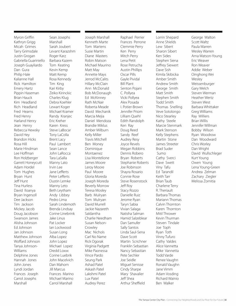
myron GriffinKathryn Griggmicah GrimesTarry GrimsdaleJustin GroganGabriella GuarinielloJoseph GuayliardoDan GuraPhilip HaleKalianne HallRick Hamiltonemery HartzPippin Hasemanbrian HauckKim HeadlandRich HeadlandFred HearnsFred HenryHarland HenryJean HenryRebecca HewskyDavid Heybrandon HicksRosa Hillmarie HindmanLee HoffmanRon HolzbergerGarrett HoneycuttAdam HordelTom Hughesbryan HuntJeff HuntTina HurlessDavid Iloanyabryan IngersollDee JacksonTim Jacksonmickey JacobDoug JacobsonSwanson JamesAlisha Johnsoned JohnsonJan Johnsonmatthew JohnsonWoffard JohnsonTanya Johnson-WilliamsDelphine JonesHannah JonesJohn JonesLyndi JordanFrances Joseph Carrol Josephs marshall
Sean Josephs marshallSarah JoubertLevant KarazshmRoger Karzbarbara KazemTom KeatingKevin Kempmatt KempRosa KennedyTim KingKari KirbyZeiko KirinckicCharles KlugDebra KoehlerLewart Kogermichael KramerRandy Kranjeceric KreherKaren KressSteve LabocarTony LaCollabrent LacyPaul LambertSean LanceJohn LaRoccaTara LaSallamanny LatoIrvin LeeJane LeffertsPeter LeffertsDustin Lemkemanny Letobeth LeythamAndy LibbeyPedro LimaSarah Lindemothbrenda LindsayCorine LinebrinkJake LinusPat LockerIan LockwoodSusan LongAlba LopezJohn Lopezmichael LopezDredd LoxxxCorine LuebrikJohn macelvichDan mahornJill marcusFrances marinomichael marinoCarrol marshall
Joseph marshallKenneth marte Tom martensSusie martinDiane mastersRobin matsonmichael maurinomatt mayAnnette maysJerrod mcCalitsHillary mcClainAnn mcDonaldbob mcDonaughed mcKinneyRath mcNairRoberta meadeDavid mechanikmarcia mejiaDaniel mendozabrandie miklusAmber milburnKelly millerTravis mitchellben moneyDominique montaenezLisa montelioneJames mooreLeroy moorePaul mooreGloria moredaJoseph moredabeverly morrowTeresa mosleybarb mulryanTom mulryanDavid murrellJackie Nazareth SaldanthaCharlie NeedhamSusan Nelson-Crowleymac NicholsCarl No NameRick Ogorakvirginia Padgettmike Paonessavince PardoSeung ParkAshad PatelAskash PatelLakshmi PatelLux PatelAudrey Perez
Raphael PerrierFrances PerroneClemmie PerryKen Perrymitch PerryLena PetitRose PetruchaAustin PhillipsOscar PillsGayle Pividalbill PlantSenton PojaniC. Pollyeavicki PollyeaAlex PosadaI. Potier-brownJennifer PriomLilliam Quehledith RandolphKen RayDoug ReedSandy ReefAudrey ResyJoyce Revelsmegan RobbinsDennis Roberobryan RobertsStephanie RobertsJoe RobinsonShayra RosarioConnie RoseSteve RosenstockJeff RoyStacy RozzoDanielle RuizJerome RyanTaryn Sabiavivian SalagaNatisha SalmanHamid SalzeblearDan SamuferSally SantosLinda Saul-SenaDave Scottmartin ScrichnerFranklin SebastianNancy SebastianPete SechlerJoe Seidlemiguel SenisseCindy Sharpemary ShavalierJeff SheaArthur Sheffield
Lorrin ShepardAnne ShieldsLew SibertSharon SibertKen SidesStephen SienaJeffrey SiewertDave SishKimila SkibickaAmber SmithAndrew SmithGeorge Smithmatt SmithStephen Smith Todd Smith Thomas Snellingveve SotolongoNico StearleyKathy Steelemarcie Stenmarkmark StensonKelly Stephensmartin StoneJames Streeterbrad Suder SumoCathy SverciDave Swettviny Tafued TarandilKeith Tarrbrian TaubCharlene TerryR. Theriaultbarbara Thomasmariann ThomasCalvin ThorntonKaren Thorntonmitil ThrowerKevin ThurmanSteven TindaleJoe TophRyan Tothvinny TufuroCathy valdesAlice vannettamike vannettaTodd vardeRenee vaughnRonald vaughnJane vimmAdam vosdingRichard Wainioben Walker
George WaltonScott WaltzPaula WarrenWesley WarrenArna Watson-Youngeric WeaverRon WeaverAddie WeberOinghong Wei Wesley WeissenburgerGary WelchSteven WermanHeather WertzSteven Westbarbara WhittakerGreg WilliamsRay Williersbrian WillisJennifer Willmanbobby WilsonRyan WoodrowDan WoodwardChris WorleyDan WrightDavid WullschlegerKurt YoungOwen YoungLena Young-GreenAndrea ZelmanZachary Zieglermelissa Zornitia
The Tampa Center City Plan - Connecting Our Neighborhoods and Our River for Our Future | iii
Summary
Tampa is defining the future in its Center City: the downtown and close-in neighborhoods. The path is toward a 21st century model for livability, sustainability and economic vitality based on five BUILDING BLOCKS for the Future:
ARe-imaginedandRefocusedWaterfront. The Waterfront is accessible, comfortable, safe and highly active; extending value into the community through increased connectivity from the neighborhoods and integration with development.
LivableConnections.Center City streets are neighborhood-focused, connected and calm, creating the environment for new businesses, residential investment, and safe pedestrian and bicycle access around town.
AnUrbanPatternThatSupportsTransit – Center City neighborhoods and activity nodes are linked to one another and to regional destinations with multi-modal transit that is well-funded, dependable, user friendly, and progressive.
StrongandLivableCenterCityNeighborhoods. The Center City neighborhoods are vibrant, diverse, safe and sustainable as multi-generational places featuring renewed housing choices, stronger schools and parks and active mixed use main streets that provide daily shopping and unique local places.
AMixed-Use,WalkableDowntownCore. Downtown is repositioned as a desirable local place for people to live, while supporting growing regional employment, leisure and culture, healthcare, and academic attractors with an improved public realm to support a viable downtown village.
Tampa has been working toward the future model for downtown for some years and is beginning to see real success. New community celebrations are held on the Riverwalk at Curtis Hixon Park. Downtown is a place of new business, hi-tech research and education, museums and performing arts, sports and hospitality – while incorporating significant new residential to bring a 24 hour life to the City. Historic neighborhoods and their main streets are experiencing restoration and reinvestment with diverse uses and people. Streetscape, trail, and transit programs are expanding to better connect the community.
The InVision Tampa program explores these trends, and, with the benefit of significant community input, provides a view toward its future as a successful and competitive waterfront city. The purpose of this plan is to engage in a broad-based community discussion about the future, crystallize the ideas, and ingrain the vision in actions going forward. It allows agility to meet evolving opportunities while ensuring that incremental investments occur within a larger framework that is aligned with a future vision that was developed by the community.
Tampa will be a model 21st century community, progressing to realize its potential; always focusing on connection to its diverse people, unique places and special relationship with water.
CeNTeR CITY TAmPA WILL be COmmUNITY OF LIvAbLe PLACeS, CONNeCTeD PeOPLe, AND COLLAbORATIve PROGReSS THAT embRACeS
AND CeLebRATeS ITS RIveR AND WATeRFRONT.
iv | The Tampa Center City Plan - Connecting Our Neighborhoods and Our River for Our Future
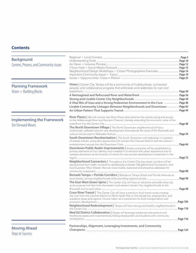
BackgroundContext, Process, and Community Issues
Planning FrameworkVision + Building Blocks
Implementing the FrameworkTen Forward Moves
Moving AheadSteps to Success
Contents
Page5Page10
Page16
Page40
Page12
Page36
Page19
Page42
Page14
Page38
Page25
Page44
Page28
Page48
Page56
Page64
Page72
Page80
Page90
Page98
Page104
Page110
Page124
Page116
Regional + Local Context Understanding ScaleAn Open + Inclusive ProcessI-Town Halls + Social Media OutreachNeighborhood Design Workshops + Citizen Photographers ExercisesImportant Community Issues + TopicsIssues + Opportunities: Cities in Motion
Vision | Center City Tampa will be a community of livable places, connected people, and collaborative progress that embraces and celebrates its river and waterfront.A Reimagined and Refocused River and WaterfrontStrong and Livable Center City NeighborhoodsA Vital Mix of Uses and a Strong Pedestrian Environment in the CoreLivable Community Linkages Between Neighborhoods and DowntownAn Urban Pattern That Supports Transit
River Places | We will nurture new River Places that enhance the activity along and access to the Hillsborough River and Garrison Channel, thereby extending the economic value of the waterfront into the Center City. The North Downtown Village | The North Downtown neighborhood will be a multimodal, walkable area for new development that extends the value of the Riverwalk and cultural venues east to Nebraska Avenue. South Downtown Reurbanization | The South Downtown will redevelop in a pattern of streets, blocks, and public spaces that will connect the Channel District with the cultural + entertainment venues into the Downtown Core.
Downtown Public Realm Improvements | Streets and parks will be established as primary elements of civic identity and invested in to enhance the urban experience and to catalyze downtown as the location of choice for new private development investment in the region.
Neighborhood Connectors | Throughout the Center City, key street corridors will be repositioned from traffic conduits to residentially-oriented ‘Neighborhood Connectors’ and local business ‘Main Streets’ that are more livable, balanced and attractive addresses for community investment.
Remade Tampa + Florida Corridors | Rebalance Tampa Street and Florida Avenues as local streets, joining neighborhoods while providing regional access. The East-West Green Spine | The Center City will have an attractive and safe cross-city multi-purpose trail that links the eastern and western Center City neighborhoods to the Riverwalk and to each other.
Cross River Transit | The Center City will have a premium local transit route crossing the river from the Channel District to North Hyde Park to link residential, employment, and academic areas and capture ‘choice riders’ as a mechanism for both transportation and economic development.
Neighborhood Redevelopment | Tampa will have strong and healthy neighborhoods in the Center City.
Med Ed District Collaboration | Tampa will leverage substantial educational and healthcare assets and investments by linking employment and students with community revitalization.
Partnerships, Alignment, Leveraging Investments, and Community Champions
The Tampa Center City Plan - Connecting Our Neighborhoods and Our River for Our Future | v

The Tampa Center City PlanIntroduction + Overview
WhatisTheTampaCenterCityPlan?The Tampa Center City Plan is a master plan creating a vision of the 21st Century City Center of Tampa, that recognizes that its future as a vibrant, livable, and sustainable community depends upon connecting its people, redefining its places, and igniting progress. The scope of the plan is ambitious, spanning from downtown to Ybor City on the east, Armenia Avenue on the west, and north along historic Nebraska Avenue to Hillsborough Avenue.
Working closely with Mayor Buckhorn, the planning team and experts and scholars with worldwide experience and insight have walked, talked, photographed, mapped and — most importantly — listened to the community about the nuances of their neighborhoods as well as the things that matter to them and their families now and in the future. With the perspective of Tampa’s people and places, the plan that emerged is a very actionable agenda for economic progress, one that links market opportunities with supportive policies and a critical mass of both grassroots and grass tops advocates, charting a path that will catalyze prosperity and a high quality of life for all of Tampa and Hillsborough County.
HowisthePlanOrganized?The plan is a vision for change over time. It allows agility to meet evolving market and demographic conditions while ensuring that incremental moves occur within a larger framework and are aligned with a future vision of the Center City that was developed by the community. This framework is made up of a sINgle vIsIoN, supported by fIve BuIldINg BloCks, and implemented initially through TeN forWArd Moves.
The vIsIoN describes the Center City of the future. It is aspirational and broad, setting a course for the future. The BuIldINg BloCks, which describe the future goals for the Center City in broad principles, are based on five key focus areas. They are intended to describe a direction and key outcomes for each focus area. Their consistent application is key to reaching the vision. The forWArd Moves outline key initial actions for the City and community to take to move toward the vision. They have been created through thoughtful consultation with stakeholders, but represent only one of potentially many solutions consistent with the vision and Building Blocks. The plans and imagery shown with the forward Moves are intended to be indicative of the character and intent of the recommended actions.
The Tampa Center City Plan - Connecting Our Neighborhoods and Our River for Our Future | 1
BackgroundContext, Process and Community Issues
4 | The Tampa Center City Plan - Connecting Our Neighborhoods and Our River for Our Future
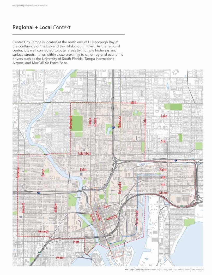
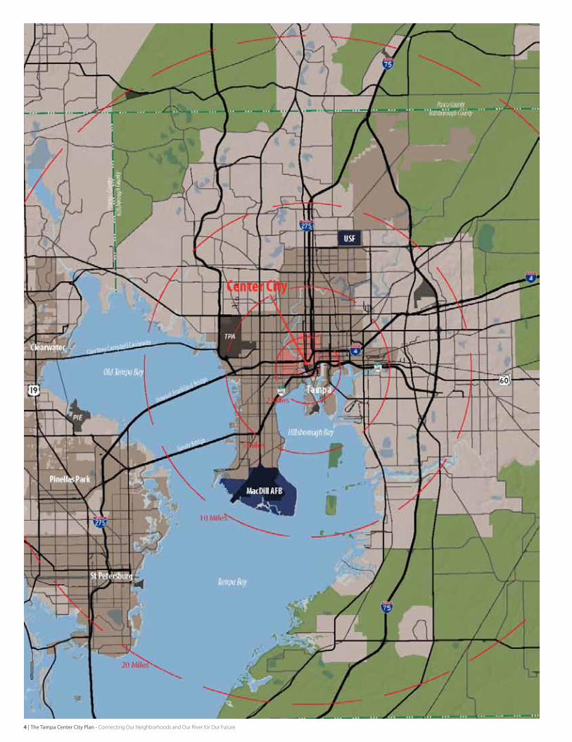
Regional + Local Context
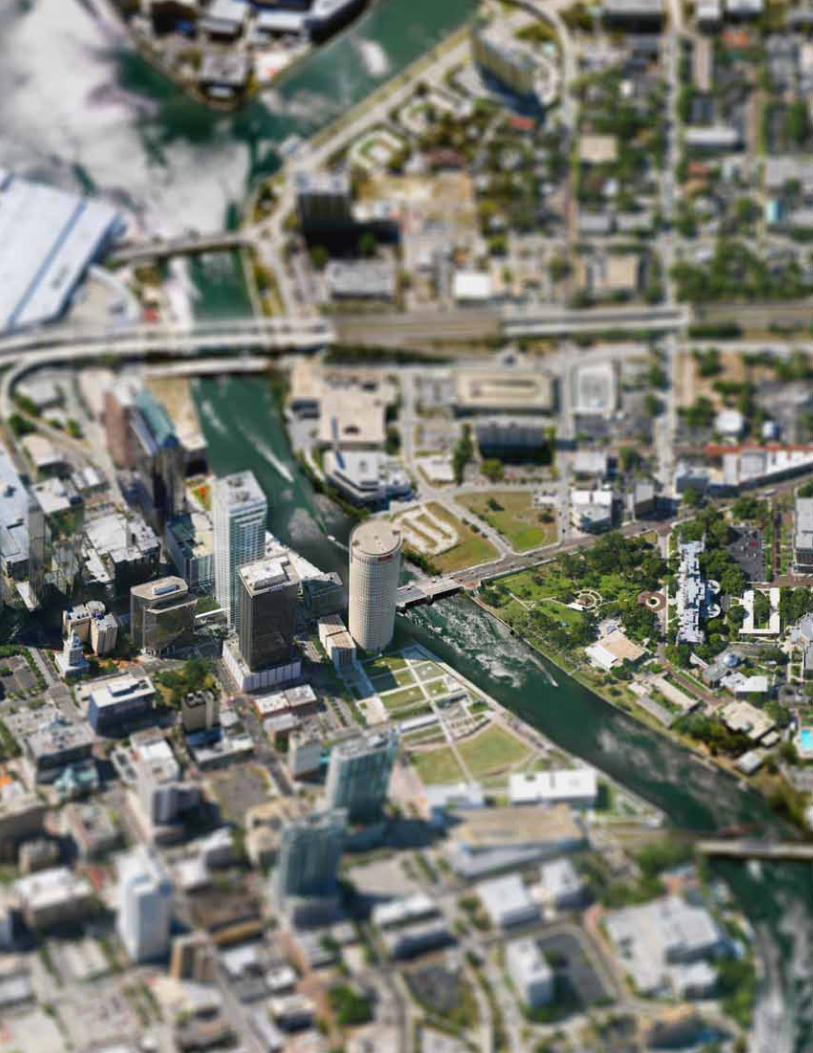
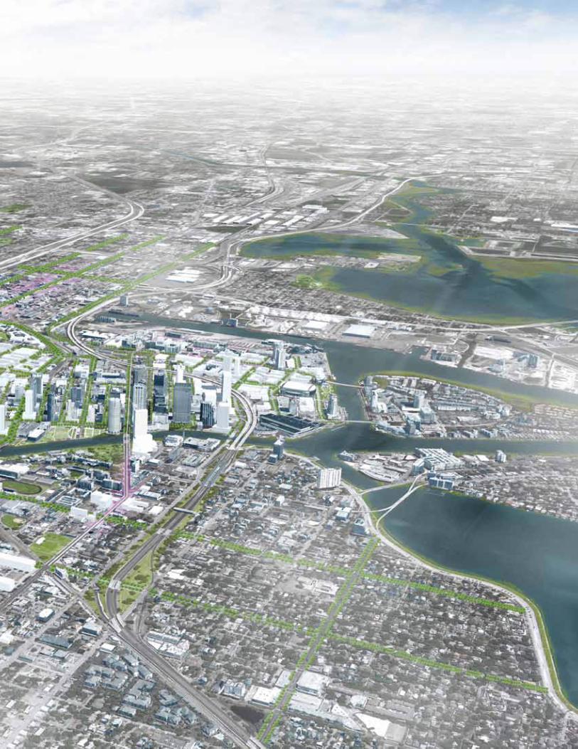
Center City Tampa is located at the north end of Hillsborough Bay at the confluence of the bay and the Hillsborough river. As the regional center, it is well connected to outer areas by multiple highways and surface streets. It lies within close proximity to other regional economic drivers such as the university of south florida, Tampa International Airport, and Macdill Air force Base.
Nebr
aska
15th
Florid
aTa
mpa
Boule
vard
Arm
enia
Rom
e
Columbus
21st
PalmPalm
7th
4th
Adamo
Lake
MLK
Howa
rd
Willo
w
Chan
nelsi
de
Nebr
aska
Kennedy
Platt
Swann
Cass
Kennedy
Franklin
Ashley
The Tampa Center City Plan - Connecting Our Neighborhoods and Our River for Our Future | 5
Background | Context, Process, and Community Issues
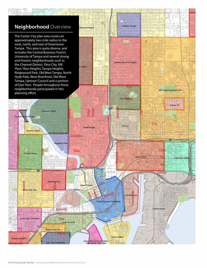
The Center City plan area covers an approximately two-mile radius to the west, north, and east of Downtown Tampa. This area is quite diverse, and includes the Central Business Fistrict, University of Tampa and several strong and historic neighborhoods such ss the Channel District, Ybor City, VM Ybor, Ybor Heights, Tampa Heights, Ridgewood Park, Old West Tampa, North Hyde Park, West Riverfront, Old West Tampa, Uptown Council and a portion of East Ybor. People throughout these neighborhoods participated in this planning effort.
Neighborhood Overview
Nebr
aska
15th
Florid
aTa
mpa
Boule
vard
Arm
enia
Rom
e
Columbus
21st
PalmPalm
7th
4th
Adamo
Lake
MLK
Howa
rd
Willo
w
Chan
nelsi
de
Nebr
aska
Kennedy
Platt
Swann
Cass
Kennedy
Franklin
Ashley
6 | The Tampa Center City Plan - Connecting Our Neighborhoods and Our River for Our Future
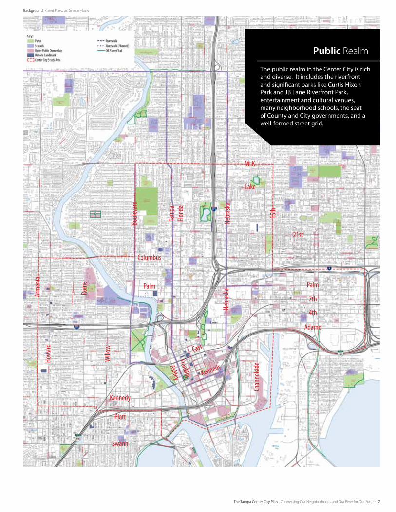
The public realm in the Center City is rich and diverse. It includes the riverfront and significant parks like Curtis Hixon Park and JB Lane Riverfront Park, entertainment and cultural venues, many neighborhood schools, the seat of County and City governments, and a well-formed street grid.
Public Realm
Nebr
aska
15th
Florid
aTa
mpa
Boule
vard
Arm
enia
Rom
e
Columbus
21st
PalmPalm
7th
4th
Adamo
Lake
MLK
Howa
rd
Willo
w
Chan
nelsi
de
Nebr
aska
Kennedy
Platt
Swann
Cass
Kennedy
Franklin
Ashley
The Tampa Center City Plan - Connecting Our Neighborhoods and Our River for Our Future | 7
Background | Context, Process, and Community Issues
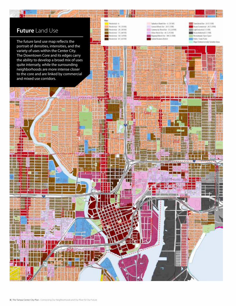
The future land use map reflects the portrait of densities, intensities, and the variety of uses within the Center City. The Downtown Core and its edges carry the ability to develop a broad mix of uses quite intensely, while the surrounding neighborhoods are more intense closer to the core and are linked by commercial and mixed use corridors.
Future Land Use
Nebr
aska
15th
Florid
aTa
mpa
Boule
vard
Arm
enia
Rom
e
Columbus
21st
PalmPalm
7th
4th
Adamo
Lake
MLK
Howa
rd
Willo
w
Chan
nelsi
de
Nebr
aska
Kennedy
Platt
Swann
Cass
Kennedy
Franklin
Ashley
8 | The Tampa Center City Plan - Connecting Our Neighborhoods and Our River for Our Future
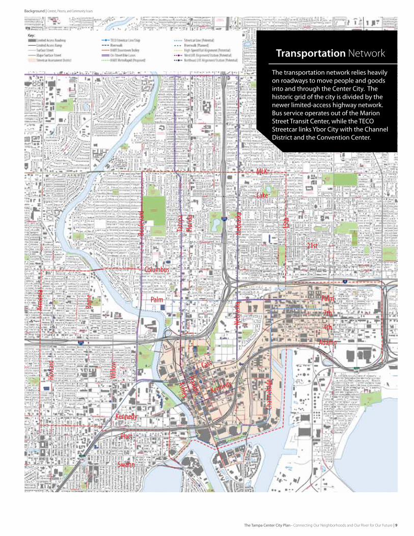
The transportation network relies heavily on roadways to move people and goods into and through the Center City. The historic grid of the city is divided by the newer limited-access highway network. Bus service operates out of the Marion Street Transit Center, while the TECO Streetcar links Ybor City with the Channel District and the Convention Center.
Transportation Network
Nebr
aska
15th
Florid
aTa
mpa
Boule
vard
Arm
enia
Rom
e
Columbus
21st
PalmPalm
7th
4th
Adamo
Lake
MLK
Howa
rd
Willo
w
Chan
nelsi
de
Nebr
aska
Kennedy
Platt
Swann
Cass
Kennedy
Franklin
Ashley
Background | Context, Process, and Community Issues
The Tampa Center City Plan - Connecting Our Neighborhoods and Our River for Our Future | 9
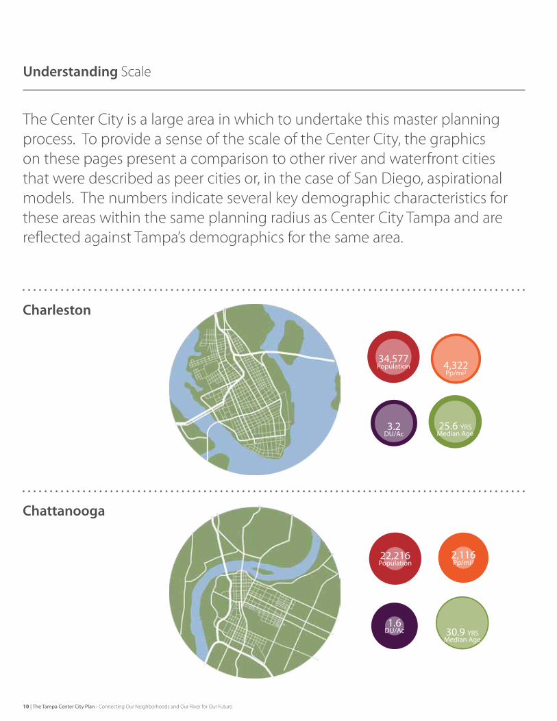
Understanding Scale
The Center City is a large area in which to undertake this master planning process. To provide a sense of the scale of the Center City, the graphics on these pages present a comparison to other river and waterfront cities that were described as peer cities or, in the case of San Diego, aspirational models. The numbers indicate several key demographic characteristics for these areas within the same planning radius as Center City Tampa and are reflected against Tampa’s demographics for the same area.
Charleston
Chattanooga
10 | The Tampa Center City Plan - Connecting Our Neighborhoods and Our River for Our Future
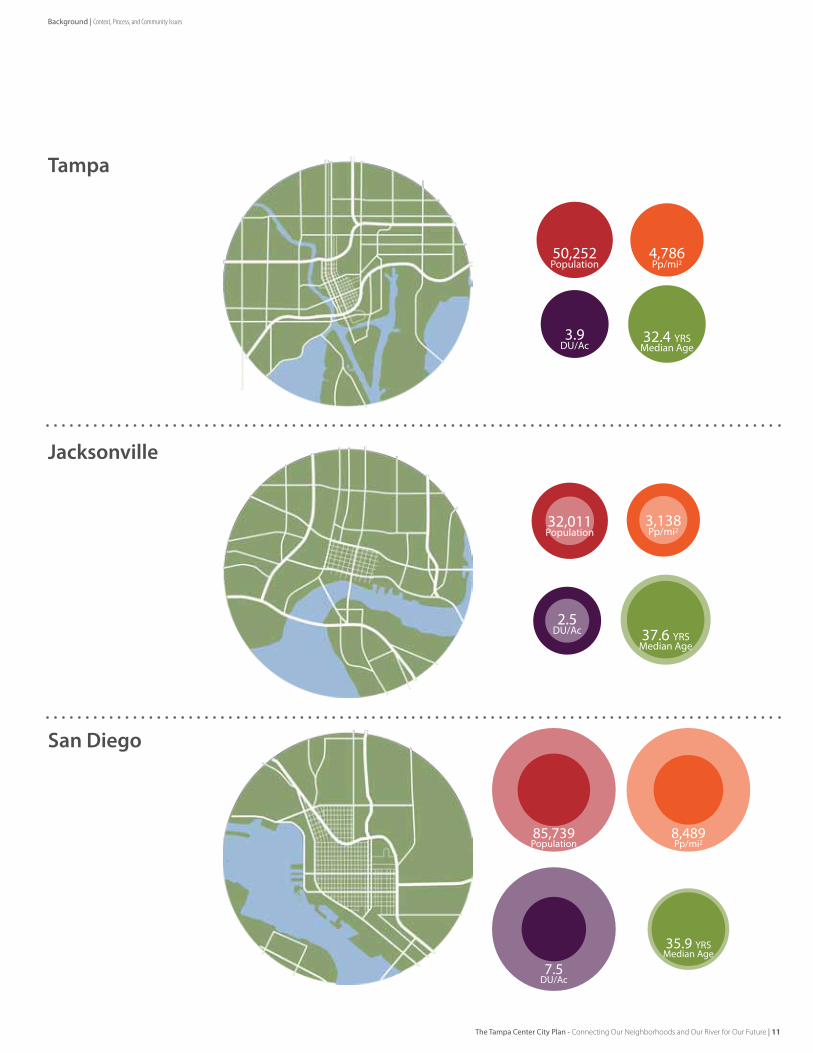
Tampa
Jacksonville
San Diego
Background | Context, Process, and Community Issues
The Tampa Center City Plan - Connecting Our Neighborhoods and Our River for Our Future | 11
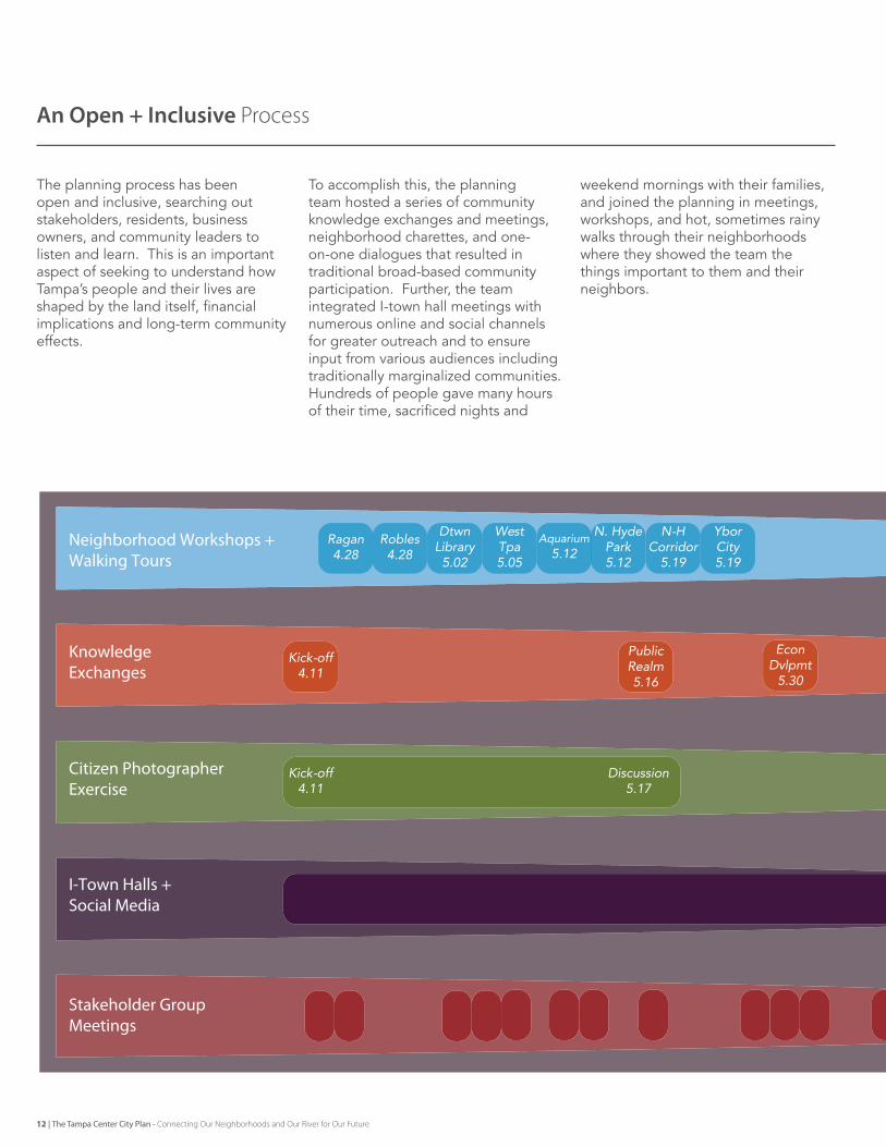
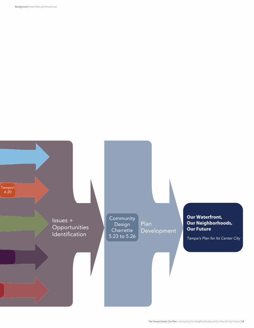
An Open + Inclusive Process
The planning process has been open and inclusive, searching out stakeholders, residents, business owners, and community leaders to listen and learn. This is an important aspect of seeking to understand how Tampa’s people and their lives are shaped by the land itself, financial implications and long-term community effects.
To accomplish this, the planning team hosted a series of community knowledge exchanges and meetings, neighborhood charettes, and one-on-one dialogues that resulted in traditional broad-based community participation. further, the team integrated I-town hall meetings with numerous online and social channels for greater outreach and to ensure input from various audiences including traditionally marginalized communities.Hundreds of people gave many hours of their time, sacrificed nights and
weekend mornings with their families, and joined the planning in meetings, workshops, and hot, sometimes rainy walks through their neighborhoods where they showed the team the things important to them and their neighbors.
Neighborhood Workshops +Walking Tours
KnowledgeExchanges
Citizen PhotographerExercise
I-Town Halls +Social Media
Stakeholder GroupMeetings
Kick-off4.11
Ragan4.28
West Tpa5.05
Robles4.28
Kick-off4.11
Discussion5.17
Public Realm5.16
Dtwn Library5.02
Aquarium5.12
YborCity5.19
N. Hyde Park5.12
N-HCorridor
5.19
EconDvlpmt
5.30
12 | The Tampa Center City Plan - Connecting Our Neighborhoods and Our River for Our Future
Background | Context, Process, and Community Issues
Issues +OpportunitiesIdentification
Our Waterfront,Our Neighborhoods,Our Future
Tampa’s Plan for Its Center City
Transport6.20
PlanDevelopment
CommunityDesign
Charrette5.23 to 5.26
The Tampa Center City Plan - Connecting Our Neighborhoods and Our River for Our Future | 13
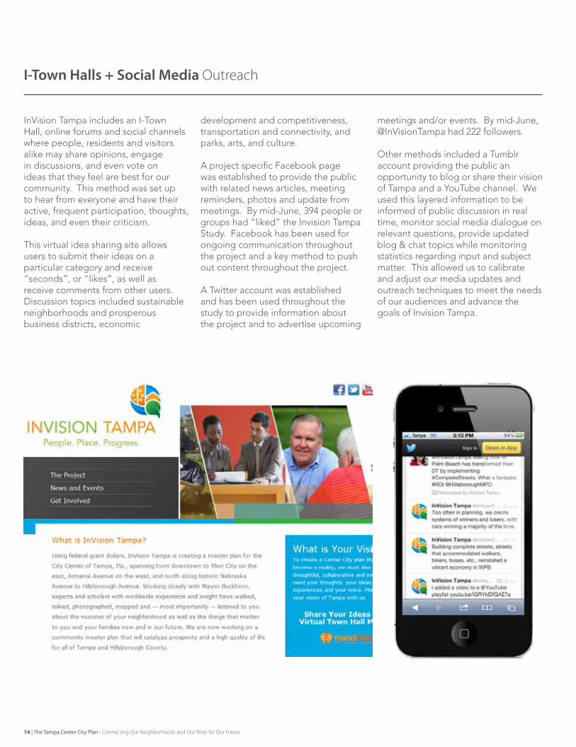
InVision Tampa includes an I-Town Hall, online forums and social channels where people, residents and visitors alike may share opinions, engage in discussions, and even vote on ideas that they feel are best for our community. This method was set up to hear from everyone and have their active, frequent participation, thoughts, ideas, and even their criticism.
This virtual idea sharing site allows users to submit their ideas on a particular category and receive “seconds”, or “likes”, as well as receive comments from other users. Discussion topics included sustainable neighborhoods and prosperous business districts, economic
development and competitiveness, transportation and connectivity, and parks, arts, and culture.
A project specific Facebook page was established to provide the public with related news articles, meeting reminders, photos and update from meetings. By mid-June, 394 people or groups had “liked” the Invision Tampa Study. Facebook has been used for ongoing communication throughout the project and a key method to push out content throughout the project.
A Twitter account was established and has been used throughout the study to provide information about the project and to advertise upcoming
meetings and/or events. By mid-June, @InVisionTampa had 222 followers.
Other methods included a Tumblr account providing the public an opportunity to blog or share their vision of Tampa and a YouTube channel. We used this layered information to be informed of public discussion in real time, monitor social media dialogue on relevant questions, provide updated blog & chat topics while monitoring statistics regarding input and subject matter. This allowed us to calibrate and adjust our media updates and outreach techniques to meet the needs of our audiences and advance the goals of Invision Tampa.
I-Town Halls + Social Media Outreach
14 | The Tampa Center City Plan - Connecting Our Neighborhoods and Our River for Our Future
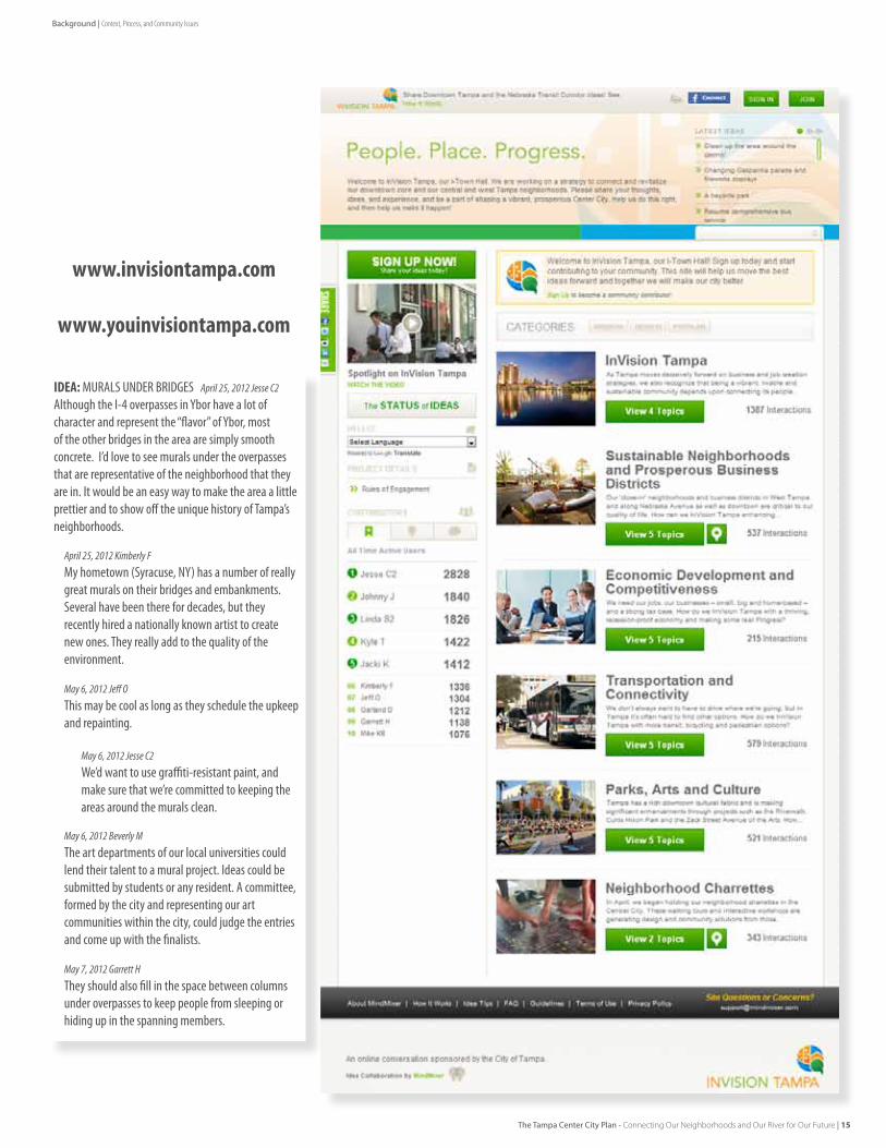
IDEA: MURALS UNDER BRIDGES April 25, 2012 Jesse C2
Although the I-4 overpasses in Ybor have a lot of character and represent the “flavor” of Ybor, most of the other bridges in the area are simply smooth concrete. I’d love to see murals under the overpasses that are representative of the neighborhood that they are in. It would be an easy way to make the area a little prettier and to show off the unique history of Tampa’s neighborhoods.
April 25, 2012 Kimberly F
My hometown (Syracuse, NY) has a number of really great murals on their bridges and embankments. Several have been there for decades, but they recently hired a nationally known artist to create new ones. They really add to the quality of the environment.
May 6, 2012 Jeff O
This may be cool as long as they schedule the upkeep and repainting.
May 6, 2012 Beverly M
The art departments of our local universities could lend their talent to a mural project. Ideas could be submitted by students or any resident. A committee, formed by the city and representing our art communities within the city, could judge the entries and come up with the finalists.
May 7, 2012 Garrett H
They should also fill in the space between columns under overpasses to keep people from sleeping or hiding up in the spanning members.
May 6, 2012 Jesse C2
We’d want to use graffiti-resistant paint, and make sure that we’re committed to keeping the areas around the murals clean.
www.invisiontampa.com
www.youinvisiontampa.com
Background | Context, Process, and Community Issues
The Tampa Center City Plan - Connecting Our Neighborhoods and Our River for Our Future | 15
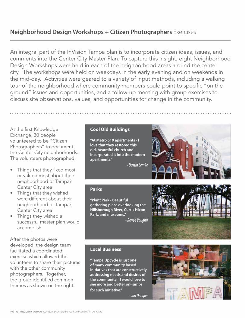
At the first knowledge exchange, 30 people volunteered to be “Citizen Photographers” to document the Center City neighborhoods. The volunteers photographed:
• Things that they liked most or valued most about their neighborhood or Tampa’s Center City area
• Things that they wished were different about their neighborhood or Tampa’s Center City area
• Things they wished a successful master plan would accomplish
After the photos were developed, the design team facilitated a coordinated exercise which allowed the volunteers to share their pictures with the other community photographers. Together, the group identified common themes as shown on the right.
An integral part of the Invision Tampa plan is to incorporate citizen ideas, issues, and comments into the Center City Master Plan. To capture this insight, eight Neighborhood design Workshops were held in each of the neighborhood areas around the center city. The workshops were held on weekdays in the early evening and on weekends in the mid-day. Activities were geared to a variety of input methods, including a walking tour of the neighborhood where community members could point to specific “on the ground” issues and opportunities, and a follow-up meeting with group exercises to discuss site observations, values, and opportunities for change in the community.
Neighborhood Design Workshops + Citizen Photographers exercises
Cool Old Buildings
“At Metro 510 apartments - I love that they restored this old, beautiful church and incorporated it into the modern apartments.”
- Dustin Lemke
Parks
“Plant Park - Beautiful gathering place overlooking the Hillsborough River, Curtis Hixon Park, and museums.”
- Renee Vaughn
Local Business
“Tampa Upcycle is just one of many community based initiatives that are constructively addressing needs and desires of the community. I would love to see more and better on-ramps for such initiative.”
- Jon Dengler
16 | The Tampa Center City Plan - Connecting Our Neighborhoods and Our River for Our Future
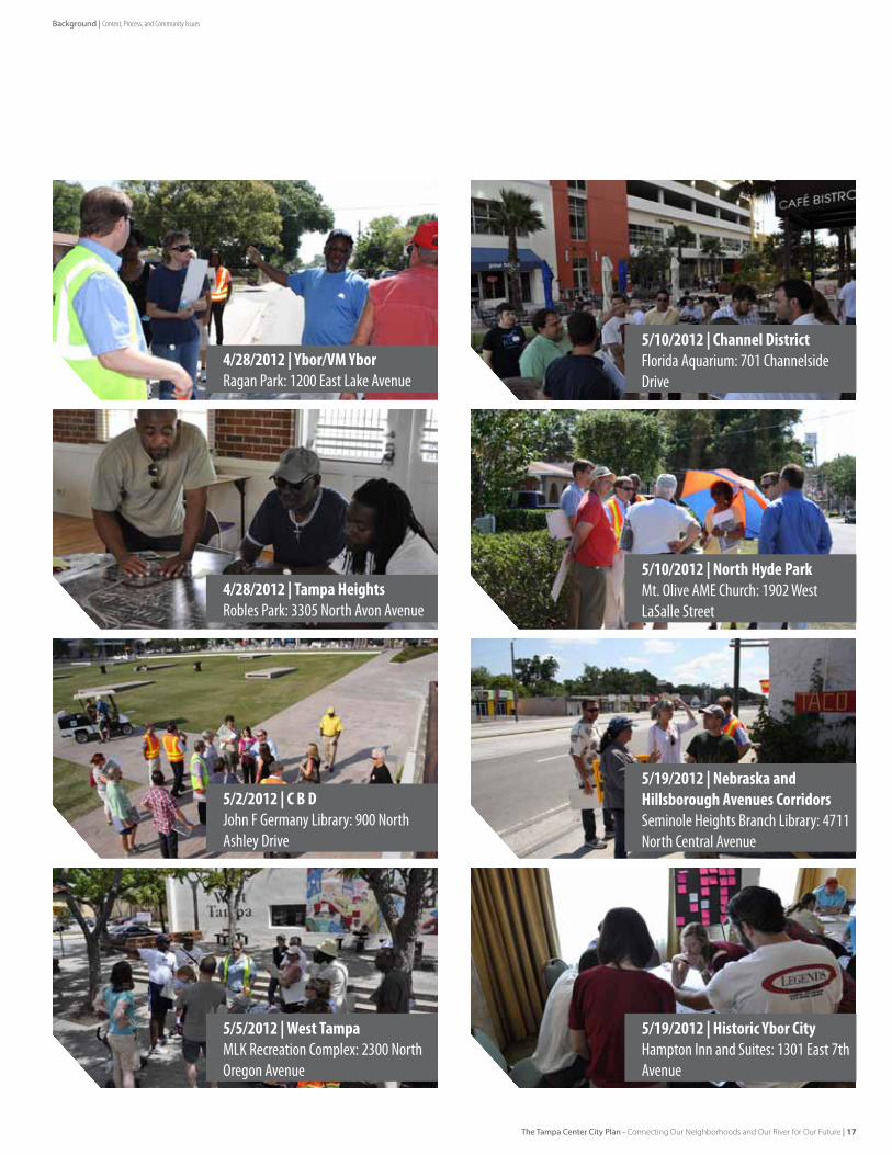
4/28/2012|Ybor/VMYborRagan Park: 1200 East Lake Avenue
5/2/2012|CBDJohn F Germany Library: 900 North Ashley Drive
5/19/2012|NebraskaandHillsboroughAvenuesCorridorsSeminole Heights Branch Library: 4711 North Central Avenue
5/10/2012|NorthHydeParkMt. Olive AME Church: 1902 West LaSalle Street
5/10/2012|ChannelDistrictFlorida Aquarium: 701 Channelside Drive
5/5/2012|WestTampaMLK Recreation Complex: 2300 North Oregon Avenue
5/19/2012|HistoricYborCityHampton Inn and Suites: 1301 East 7th Avenue
4/28/2012|TampaHeightsRobles Park: 3305 North Avon Avenue
Background | Context, Process, and Community Issues
The Tampa Center City Plan - Connecting Our Neighborhoods and Our River for Our Future | 17
Growing number of people investing in the urban neighborhoodsVery strong local belief that we need local transit to serve downtown core (business, cultural venues, tourism and residential)
Reward non-auto trips, make it more attractive to take transitPlaces that are close feel far because the walk is difficult
Need more things to do along Riverwalk (Access, Dining, Entertainment)Large roads and ramps isolate key properties such as Straz Center and North Franklin
Need more places of density / activity to support transitExisting and emergent business districts (such as Willow Ave) have great potential for enhancement and neighborhood supportive activities
Explore new partnerships that can create new or enhanced places (Med-Ed District? Channelside Mixed Use area?)Safety and security
It’s confusing to get in and out of the downtown coreToo many inexpensive surface lots (it’s still too easy to drive)
HART annual ridership is growing (+/- $14.5M downtown annually)With its urban streets and small blocks, Tampa should be the most walkable, bikeable City in Florida
Transit systems around downtown do not meet the needs of the local populationsThe urban neighborhoods each have their own unique mixed use blend of housing, parks and local business areas
Many surface parking lots in Downtown Core make the place feel disjointedCan’t see the river from adjacent streets – river doesn’t have much presence in the City or Neighborhoods
Need future regional transit that gets to USF, Airport, Westshore and regionally to St Pete, Beaches, etcTampa has a very well connected system of streets and blocks
Downtown events and activities are important to the life of the communityMarion Street Central Station needs more capacity.
Tampa has a strong culture of bike ridersRiverwalk is a great amenity, enhancing the Environmental and Recreational Potential of the Hillsborough River
Transit Oriented Development, mixed use, higher density in the coreAccess to schools, parks and local shops needs improvement
There should be better urban design at the street level and streetscapes for better walkabilityPlaces that are close feel far because of the harsh walking environment
Marion Street Transitway doesn’t serve emerging areas of development and current signal timing doesn’t reward busNeed more places of density / activity to support transit
Downtown open space: Washington Street Park, Riverwalk, Curtis Hixon Park, is a community assetThe Hillsborough River and Riverwalk can be more integrated with current and future development
Initiate Zip Car, bike share programs and bring back the electric jitneysStreetcar doesn’t serve the local population
Waterfront Events and Activities are very popularPride of place and property – trash, cars in treelawns
Pedestrian crossing or enhancements to Ashley, Kennedy, Meridian, etc. would make Downtown more walkable and accessibleRedevelop North Boulevard Homes and Robles Park as mixed-use, mixed-income places
Not enough local destinations on streetcar routeExtend Riverwalk to West Bank
Diversity of housing and people in close-in neighborhoodsVery strong local belief that we need local transit to serve downtown core (business, cultural venues, tourism and residential)
Highly inconsistent streetscape design leads to poor walkabilitySurface parking lots are unsightly and create a landscape of asphalt
Balancing regional needs with local sense of place – and incorporating enhanced transit - as at the Nebraska Avenue Road diet projectLocal businesses and historic business districts
Develop some cross-town trail systemsNew business will be attracted if Downtown is a more vibrant cultural and living place
HART annual ridership is growing (+/- $14.5M downtown annually)Rebuild Riverside Park, bring in light retail and boating
Transit ticketing/fareboxes not user friendly (like e-pass) for localsDeficient utility and public realm infrastructure in some locations
Bicycle and walking facilities, especially on ‘cross-town’ routes or linkages to key destinations, such as University of TampaNeed to develop some priorities for next investment (extend to west bank of Hillsborough River, more boating facilities, comfort amenities)
We need better connections in and around the Straz Center and cultural facilitiesUse Metro-Rapid to better brand and serve the local population
Revenue stream to support expanded transit construction and service More riverfront access and activity
Jobs and need for employment opportunitiesProvide more comfort and shade to the pedestrian and park environment
The Downtown Core should include the west bank of the riverLimited places to cross the river, limited bike / ped ways
From the neighborhoods, you are close to everything downtownNew feature walk/bike bridges over river
Access in and out of downtown is difficultEasy, reliable transit that connects key cultural and employment desinations with places of residential density
Certain roads seem congested and hostile to peds and bikes, others seem oversized and underutilized by carsBetter transit connections to and from my house
Don’t give up on High Speed Rail / Statewide LinkagesReclaim streets like Columbus and Floribraska that cross the highway or river to link neighborhoods
Water Access for Boating, Paddleboarding, Kayaks, etcHealthcare, education, high tech, culture, riverfront and urban living create a downtown mix that is unusual among other southern cities
Not much reward to ride the bus Need sidewalks, street trees and bike facilities on key streets
Tampa has to balance both local circulation and regional accessReward non-auto trips, make it more attractive to take transit
Tampa Park Apartments and Con-Agra create ‘holes’ in the downtown patternWalkability in the neighborhoods
Transit-oriented development, mixed use, higher density in the coreNeed easy, local circulator that serves the downtown core
Convert the one-way streetsNeighborhood clean up days
Riverwalk is sometimes hot, not enough shade, comfortUse Metro-Rapid to better brand and serve the local population
In-town trail systems for rapid bike access (including the Selmon Expressway Trail concept) should be exploredNot many places to access the water
Develop more projects like the Nebraska Road Diet Ticketing / Fareboxes not user friendly (like e-pass) for locals
Need to improve pedestrian environment in the downtown coreTampa remains an important regional destination for employment and entertainment
Light Industrial, such as at Willow Avenue, provides opportunity for new businesses, and neighborhood supporting retailMake large roads like Ashley, Meridian, and Kennedy easier to cross
Need future regional transit that gets to USF, Airport, Westshore and regionally to St Pete, Beaches, etcExtend the presence of the river up into the city and neighborhoods
Revenue stream to support expanded transit construction and service Quality residential restoration and new mixed use investment
The Downtown Core can be viewed as many emerging neighborhoodsExtend and expand streetcar service
18 | The Tampa Center City Plan - Connecting Our Neighborhoods and Our River for Our Future
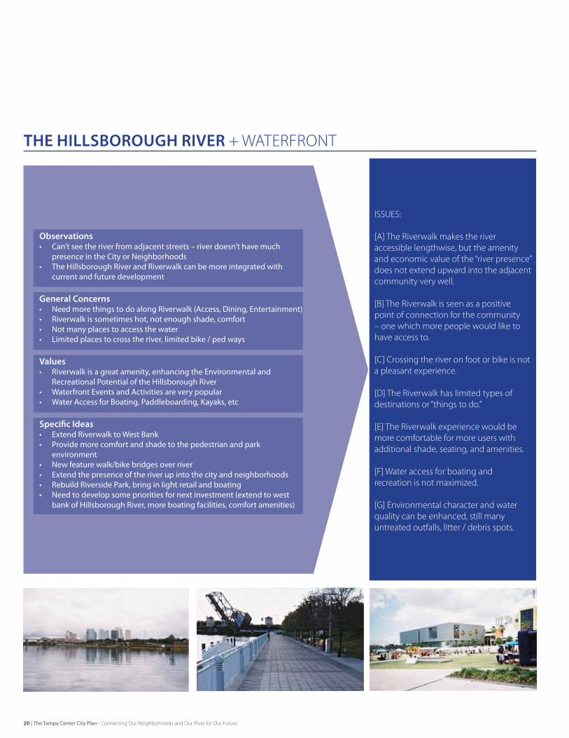
THE HILLSBOROUGH RIVER + WATeRFRONT
THE CENTER CITy NeIGHbORHOODS
TAMPA’S DOWNTOWN CORe
LIVABLE STREETS + COmmUNITY LINKAGeS
TRANSIT
Important Community Issues + Topics
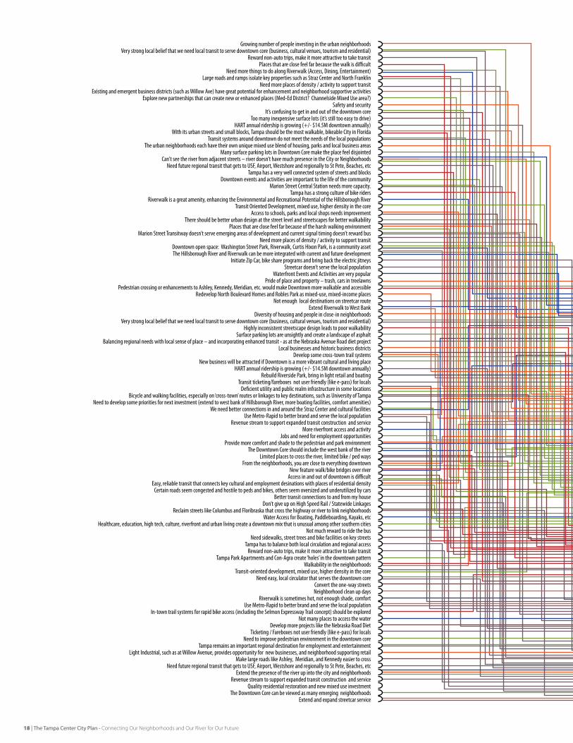
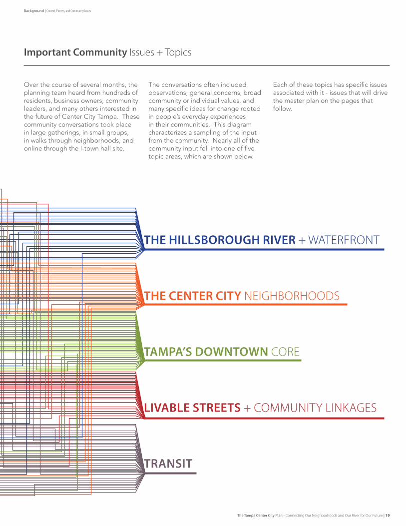
Over the course of several months, the planning team heard from hundreds of residents, business owners, community leaders, and many others interested in the future of Center City Tampa. These community conversations took place in large gatherings, in small groups, in walks through neighborhoods, and online through the I-town hall site.
The conversations often included observations, general concerns, broad community or individual values, and many specific ideas for change rooted in people’s everyday experiences in their communities. This diagram characterizes a sampling of the input from the community. Nearly all of the community input fell into one of five topic areas, which are shown below.
Each of these topics has specific issues associated with it - issues that will drive the master plan on the pages that follow.
Background | Context, Process, and Community Issues
The Tampa Center City Plan - Connecting Our Neighborhoods and Our River for Our Future | 19
THE HILLSBOROUGH RIVER + WATeRFRONT
ISSUeS:
[A] The Riverwalk makes the river accessible lengthwise, but the amenity and economic value of the “river presence” does not extend upward into the adjacent community very well.
[b] The Riverwalk is seen as a positive point of connection for the community – one which more people would like to have access to.
[C] Crossing the river on foot or bike is not a pleasant experience.
[D] The Riverwalk has limited types of destinations or “things to do.” [e] The Riverwalk experience would be more comfortable for more users with additional shade, seating, and amenities. [F] Water access for boating and recreation is not maximized.
[G] environmental character and water quality can be enhanced, still many untreated outfalls, litter / debris spots.
Observations• Can’t see the river from adjacent streets – river doesn’t have much
presence in the City or Neighborhoods• The Hillsborough River and Riverwalk can be more integrated with
current and future development
General Concerns• Need more things to do along Riverwalk (Access, Dining, Entertainment)• Riverwalk is sometimes hot, not enough shade, comfort• Not many places to access the water• Limited places to cross the river, limited bike / ped ways
Values• Riverwalk is a great amenity, enhancing the Environmental and
Recreational Potential of the Hillsborough River• Waterfront Events and Activities are very popular• Water Access for Boating, Paddleboarding, Kayaks, etc
Specific Ideas• Extend Riverwalk to West Bank• Provide more comfort and shade to the pedestrian and park
environment • New feature walk/bike bridges over river• Extend the presence of the river up into the city and neighborhoods• Rebuild Riverside Park, bring in light retail and boating• Need to develop some priorities for next investment (extend to west
bank of Hillsborough River, more boating facilities, comfort amenities)
20 | The Tampa Center City Plan - Connecting Our Neighborhoods and Our River for Our Future
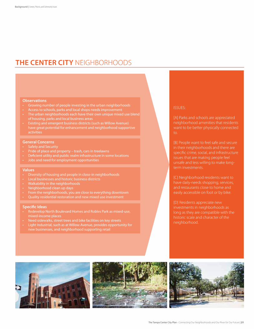
THE CENTER CITy NeIGHbORHOODS
ISSUeS:
[A] Parks and schools are appreciated neighborhood amenities that residents want to be better physically connected to.
[b] People want to feel safe and secure in their neighborhoods and there are specific crime, social, and infrastructure issues that are making people feel unsafe and less willing to make long-term investments.
[C] Neighborhood residents want to have daily-needs shopping, services, and restaurants close to home and easily accessible on foot or by bike.
[D] Residents appreciate new investments in neighborhoods as long as they are compatible with the historic scale and character of the neighborhood.
Observations• Growing number of people investing in the urban neighborhoods• Access to schools, parks and local shops needs improvement• The urban neighborhoods each have their own unique mixed use blend
of housing, parks and local business areas• Existing and emergent business districts (such as Willow Avenue)
have great potential for enhancement and neighborhood supportive activities
General Concerns• Safety and Security• Pride of place and property – trash, cars in treelawns• Deficient utility and public realm infrastructure in some locations• Jobs and need for employment opportunities
Values• Diversity of housing and people in close-in neighborhoods• Local businesses and historic business districts• Walkability in the neighborhoods• Neighborhood clean up days• From the neighborhoods, you are close to everything downtown• Quality residential restoration and new mixed use investment
Specific Ideas• Redevelop North Boulevard Homes and Robles Park as mixed-use,
mixed-income places• Need sidewalks, street trees and bike facilities on key streets• Light Industrial, such as at Willow Avenue, provides opportunity for
new businesses, and neighborhood supporting retail
Background | Context, Process, and Community Issues
The Tampa Center City Plan - Connecting Our Neighborhoods and Our River for Our Future | 21
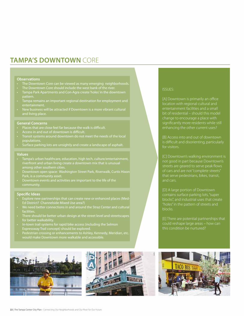
TAMPA’S DOWNTOWN CORe
ISSUeS:
[A] Downtown is primarily an office location with regional cultural and entertainment facilities and a small bit of residential – should this model change to encourage a place with significantly more residents while still enhancing the other current uses?
[b] Access into and out of downtown is difficult and disorienting, particularly for visitors.
[C] Downtown’s walking environment is not good in part because Downtown’s streets are geared to serve peak flows of cars and are not “complete streets” that serve pedestrians, bikes, transit, and cars.
[D] A large portion of Downtown contains surface parking lots, “super blocks”, and industrial uses that create “holes” in the pattern of streets and blocks.
[e] There are potential partnerships that could reshape large areas – how can this condition be nurtured?
Observations• The Downtown Core can be viewed as many emerging neighborhoods.• The Downtown Core should include the west bank of the river.• Tampa Park Apartments and Con-Agra create ‘holes’ in the downtown
pattern.• Tampa remains an important regional destination for employment and
entertainment.• New business will be attracted if Downtown is a more vibrant cultural
and living place.
General Concerns• Places that are close feel far because the walk is difficult.• Access in and out of downtown is difficult.• Transit systems around downtown do not meet the needs of the local
populations.• Surface parking lots are unsightly and create a landscape of asphalt.
Values• Tampa’s urban healthcare, education, high tech, culture/entertainment,
riverfront and urban living create a downtown mix that is unusual among other southern cities.
• Downtown open space: Washington Street Park, Riverwalk, Curtis Hixon Park, is a community asset.
• Downtown events and activities are important to the life of the community.
Specific Ideas• Explore new partnerships that can create new or enhanced places (Med-
Ed District? Channelside Mixed Use area?)• We need better connections in and around the Straz Center and cultural
facilities.• There should be better urban design at the street level and streetscapes
for better walkability.• In-town trail systems for rapid bike access (including the Selmon
Expressway Trail concept) should be explored.• Pedestrian crossing or enhancements to Ashley, Kennedy, Meridian, etc.
would make Downtown more walkable and accessible.
22 | The Tampa Center City Plan - Connecting Our Neighborhoods and Our River for Our Future
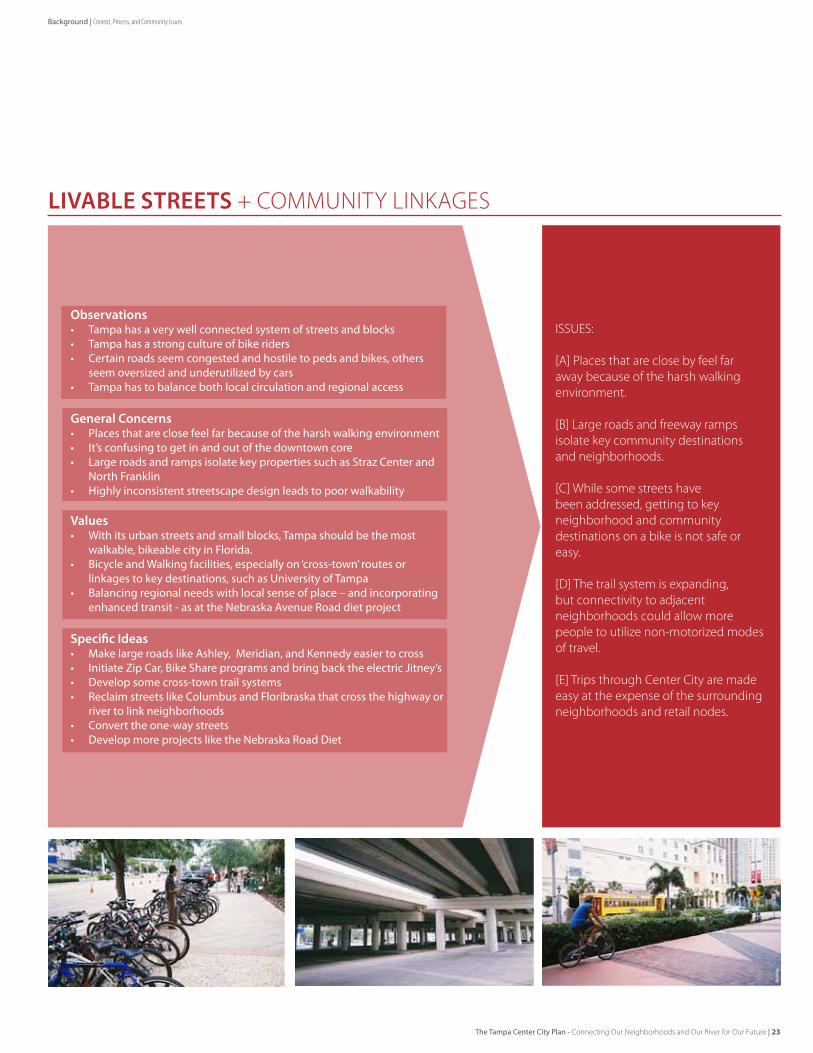
LIVABLE STREETS + COmmUNITY LINKAGeS
ISSUeS:
[A] Places that are close by feel far away because of the harsh walking environment.
[b] Large roads and freeway ramps isolate key community destinations and neighborhoods.
[C] While some streets have been addressed, getting to key neighborhood and community destinations on a bike is not safe or easy.
[D] The trail system is expanding, but connectivity to adjacent neighborhoods could allow more people to utilize non-motorized modes of travel.
[e] Trips through Center City are made easy at the expense of the surrounding neighborhoods and retail nodes.
Observations• Tampa has a very well connected system of streets and blocks • Tampa has a strong culture of bike riders• Certain roads seem congested and hostile to peds and bikes, others
seem oversized and underutilized by cars• Tampa has to balance both local circulation and regional access
General Concerns• Places that are close feel far because of the harsh walking environment • It’s confusing to get in and out of the downtown core• Large roads and ramps isolate key properties such as Straz Center and
North Franklin• Highly inconsistent streetscape design leads to poor walkability
Values• With its urban streets and small blocks, Tampa should be the most
walkable, bikeable city in Florida.• Bicycle and Walking facilities, especially on ‘cross-town’ routes or
linkages to key destinations, such as University of Tampa• Balancing regional needs with local sense of place – and incorporating
enhanced transit - as at the Nebraska Avenue Road diet project
Specific Ideas• Make large roads like Ashley, Meridian, and Kennedy easier to cross• Initiate Zip Car, Bike Share programs and bring back the electric Jitney’s• Develop some cross-town trail systems• Reclaim streets like Columbus and Floribraska that cross the highway or
river to link neighborhoods• Convert the one-way streets• Develop more projects like the Nebraska Road Diet
Background | Context, Process, and Community Issues
The Tampa Center City Plan - Connecting Our Neighborhoods and Our River for Our Future | 23
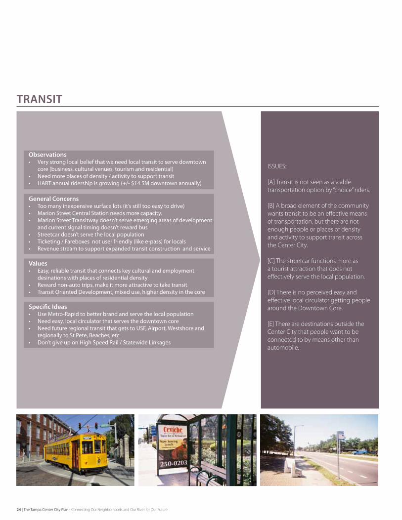
TRANSIT
ISSUeS:
[A] Transit is not seen as a viable transportation option by “choice” riders.
[b] A broad element of the community wants transit to be an effective means of transportation, but there are not enough people or places of density and activity to support transit across the Center City.
[C] The streetcar functions more as a tourist attraction that does not effectively serve the local population.
[D] There is no perceived easy and effective local circulator getting people around the Downtown Core.
[e] There are destinations outside the Center City that people want to be connected to by means other than automobile.
Observations• Very strong local belief that we need local transit to serve downtown
core (business, cultural venues, tourism and residential)• Need more places of density / activity to support transit• HART annual ridership is growing (+/- $14.5M downtown annually)
General Concerns• Too many inexpensive surface lots (it’s still too easy to drive)• Marion Street Central Station needs more capacity. • Marion Street Transitway doesn’t serve emerging areas of development
and current signal timing doesn’t reward bus• Streetcar doesn’t serve the local population• Ticketing / Fareboxes not user friendly (like e-pass) for locals• Revenue stream to support expanded transit construction and service
Values• Easy, reliable transit that connects key cultural and employment
desinations with places of residential density• Reward non-auto trips, make it more attractive to take transit• Transit Oriented Development, mixed use, higher density in the core
Specific Ideas• Use Metro-Rapid to better brand and serve the local population• Need easy, local circulator that serves the downtown core• Need future regional transit that gets to USF, Airport, Westshore and
regionally to St Pete, Beaches, etc• Don’t give up on High Speed Rail / Statewide Linkages
24 | The Tampa Center City Plan - Connecting Our Neighborhoods and Our River for Our Future
Issues + Opportunities: Cities in motion
Healthy cities are places of constant evolution - meeting the cultural and economic opportunities of the future. The physical form of the city is a reflection of way in which the community meets those opportunities. It is visible in both the natural and built environment and how places are connected in order to access the inherent activities of a diverse community. Vibrant cities maintain their unique local culture, while continually adapting to support new forms of economic prosperity and enhanced quality of life.
Tampa is a waterfront city, defined by the Hillsborough River, navigation channels, Tampa Bay and access to the Gulf of Mexico. This has been the motive for settlement and defense, shipping and trade, culture, and environment. The patterns of a long and diverse past are visible, in the forms of neighborhoods and main streets, highways and buildings, and the connection of city to water. In just the last 50 years, downtown Tampa has evolved from an industrial waterfront with working neighborhoods, to a downtown central business district with tourism, cultural venues, a world class port and growing universities. At each step in Tampa’s history, the City has made strategic choices, working to remain competitive, leveraging the value of the Water and insuring a strong community.
Today, Tampa’s people are defining the future in the Center City: the downtown and close-in neighborhoods. The path is toward a 21st Century model for livability, sustainability, and economic vitality. The approach balances Tampa’s Center City as a regionally significant place for business, industry, and culture with the local activities of small business and significant reinvestment in diverse residential. With more people living downtown, Tampa has a newfound focus on sense of place, local retail services, education, parks, and jobs. Living downtown also requires multimodal connectivity, walkable and bikeable places, and expanded access to Hillsborough River and Garrison Channel to fully experience the benefits of living in a 21st Century waterfront city.
Tampa has been working toward this model for some years and is beginning to see real success. Frequent community activities are held on the Hillsborough River at Curtis Hixon Park and the completed segments of the new Riverwalk. Downtown is a place of new business, hi-tech research, healthcare and education, trade and shipping, museums and performing arts, sports and hospitality. New residential growth is strengthening neighborhoods and adding a 24-hour life to the downtown core while local
retail and main streets are experiencing restoration and reinvestment.
The opportunity is to fully realize the potential of Center City as a livable and connected place. The input from the community clearly values the advantages of diversity and proximity: living, playing, working and learning within the unique assets of downtown. However, proximity does not equal connectivity, and there is a strong desire for enhanced linkages to access ever improving assets of Center City. Connections are physical, but also social and economic. Tampa can transform its physical infrastructure and advance its social and economic synergy through partnerships and shared vision.
This Plan focuses the community input on these ideas with an articulated Vision, Building Blocks, and example Forward Moves. The Plan is aspirational and broad, with recommendations that reflect desired outcomes from the community. It is intended to be both a guidebook for diverse stakeholders to benchmark their activities, as well as a living document for Tampa to continue to realize economic prosperity and quality of life. Tampa’s future as a sustainable waterfront community is bright.
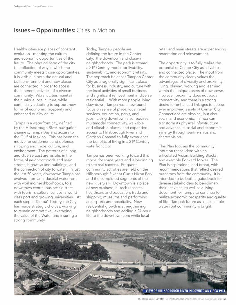
VIEW OF HILLSBOROUGH RIVER IN DOWNTOWN CIRCA 1914
Background | Context, Process, and Community Issues
The Tampa Center City Plan - Connecting Our Neighborhoods and Our River for Our Future | 25
Planning Framework vision and building blocks
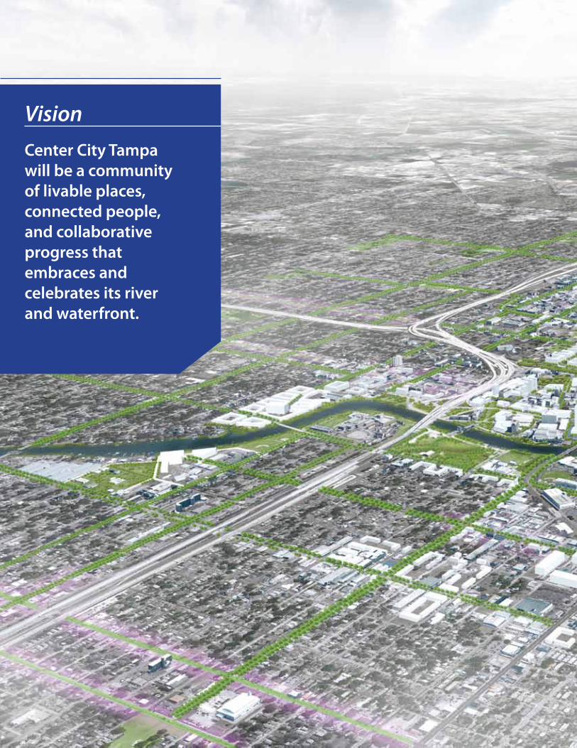
Center City Tampa will be a community of livable places, connected people, and collaborative progress that embraces and celebrates its river and waterfront.
Vision
CenterCitysupportsavibranteconomySince the days of America’s earliest settlements, waterfronts were a place for industry and commerce. The nation’s waterways were the backbone of transportation and communication, allowing factories and offices and ports to flourish in places with easy access to a river or ocean. The strongest economies in the world grew up at the confluence of major waterways. But America has gone through a wrenching de-industrialization process over the past several decades, leading to abandonment and disinvestment along many urban waterfronts. The remnants of this change have served to isolate both the people and businesses from the feature that first allowed them to prosper.
Tampa now has an incredible opportunity to reclaim its waterfront as an economic engine. The new sources of jobs and income will not be the transportation and manufacturing facilities of before, but rather 21st century companies whose employees value working in unique urban places. Entrepreneurs, who by definition are pioneers, will be attracted to the possibility of establishing economic roots in a new and dynamic place. Redevelopment of the Center City will be a catalyst for economic activity throughout the City, and will build on the downtown revitalization successes that have occurred over the past two decades.
CenterCityevokesasenseofplacePeople and businesses will be attracted to the Center City if it evokes a strong, authentic, and unique sense of place. Achieving this sense of place stems partly from design—the architecture, the transportation networks and public spaces—but also from something that is less easily planned. It is the sense of spontaneity, the slight element of surprise, the diversity of people and places and experiences that can only arise through an evolutionary process. Thoughtful attention to the design and planning details will help foster an environment where this can happen, but a sense of place can only truly emerge as people make it their place.
CenterCityhasarichpublicrealmThe river and waterfront was once a place for industry—it was not a place for people. Our values have changed with our shifting economy, however, and waterfronts are now universally recognized as a place for the public to enjoy, and as an active and exciting place for people to meet, interact, shop, work and live. Now, in cities from London to Little Rock, the water has become the defining physical and psychological feature of the community, a place residents closely associate with their quality of life. An important part of this plan will be reconnecting the residents of the Center City with their river, and giving them an urban environment that is inviting and functional with plenty of public amenities.
CenterCityconservesenergyAmerica leads the world in energy consumption, both overall and per-capita. For a long time, this was seen as a sign of our economic and technological prowess, as the indicator of a truly advanced civilization. We now understand, however, that such a rate of energy use is unsustainable. The majority of resources we consume are non-renewable; the problems of global warming and air pollution have grown in the nation’s consciousness; and nearly all geopolitical tensions can be traced, in some way, to the drive for more and more energy sources.
Reducing our energy consumption must happen through individual commitments and technological advances, but it can also be influenced through urban design. Two of the most important ways of doing this—mixing land uses and allowing for diverse transportation options—are discussed below, but we can also use design techniques such as thoughtful building alignments, landscaping, and “green” construction materials to conserve energy in our communities. The Center City, as the gateway to Tampa, will have the opportunity to showcase to the world how the City is using innovative urban design to impact energy consumption.
30 | Our Waterfront, Our Neighborhoods, Our Future - Tampa’s Plan for Its Center City
CenterCityisservedbydiversemodesoftransportationWe can no longer build communities that are solely reliant on the private automobile if we want to have a sustainable society. The amount of land and energy required for a transportation system based on cars is enormous. We must create environments that can easily be connected to efficient mass transit networks, but that also allow people to walk or bike to many of their daily destinations. Density and mixed land uses are critical parts of this equation, but so are the design details that make transit or walking an attractive option, not just a functional one. The River City plan should also envision the potential to return to waterways, a mode that served generations of people but which has been largely forgotten or underutilized, as an important means of transportation.
CenterCityhasaharmoniousmixofusesMixing land uses is perhaps the most fundamental tool that will allow us to achieve all the other goals of the Center City. Having a mix of uses will give people a reason to be there at all times of the day, will allow diverse modes of transportation to flourish, will contribute to a vibrant economy and help evoke a sense of place. Too many waterfront redevelopment projects have focused solely on high-rise condos or “urban marketplace” malls, creating value for a single set of developers but not for the larger community.
The Center City will be a place where someone can start a graphic design business, where a Tampa couple can go for an anniversary dinner, where teenagers can go shopping while their parents go to a museum, where someone can live in an apartment overlooking the beautiful Hillsborough River. It will be a place where all of these activities, and many others, are made more interesting and desirable because of their proximity to one another.
CenterCityhaspeopleThe most talented urban designers can create a place that looks beautiful. History is replete with beautiful projects
that did not plan for the people, and thus failed on nearly every objective—financial, political, and social. People will only come if we get the details right and create an inviting, engaging, dynamic place that has a soul and an identity. Attracting a diversity of people, in terms of age, income, and experiences, will also help create an authentic urban place that celebrates the contributions of these various people.
CenterCityrespectsthenaturalecologyThe previous users of the river and waterfront located their businesses there precisely because of its location on the Hillsborough River. The natural ecology of the site—the river—was the basis for development, but beyond its use for transportation, that ecology was largely ignored. Decades of neglect and degradation damaged that ecology. However, it is important to remember that there is still a functional and important ecology that could be maintained and enhanced during the redevelopment process. Utilizing low-impact design techniques, “green” building technologies, and other elements that show respect for the land will help achieve a more harmonious balance between nature and development than previously existed on the river’s edge.
CenterCityvaluescooperationandcollaborationThe best cities and neighborhoods in the world have one common thread—they have been built through an iterative process of countless individual decisions and actions. Planning for redevelopment is no different. Having a diversity of opinions, perspectives, experiences, and beliefs is absolutely vital to successfully bringing a project to life. Understanding and balancing the needs of the various stakeholders, including the public, will be the core element needed to achieve all of the goals above. It is collaboration that will make The Center City one of the world’s great river and waterfronts.
Our Waterfront, Our Neighborhoods, Our Future - Tampa’s Plan for Its Center City | 31
Planning Framework | Vision + Building Blocks

Economic Opportunities in the Core
DowntownCore+SouthDowntown Encourage Active Streets: The Downtown Core forms a primary employment center in the region with a strong concentration of commercial and government office space in addition to regional cultural and entertainment facilities and recent residential development. Transportation issues, such as congestion and lack of transit and large expanses of unimproved surface parking lots limit walkability and cohesion between neighborhood uses. Near-term opportunities exist to connect major activity centers by filling in blocks of surface parking with development and improving the streetscape environment. Surface parking should be regulated as part of a Comprehensive Parking Management collaborative program. A parking management collaborative would establish an organizational structure so that public and private sector parking owners could work together in a centralized parking coordination context. With a broader community development perspective, management would focus on larger strategic goals relative to parking policies. By formalizing the parking system, private owners would need to consider the relative value of land-banking vacant lots.
Class A Office Market Positioning: “Class A” office space in the Downtown Core has not grown in recent years, as many financial and other professional offices have relocated to sites elsewhere in the City of Tampa or in Hillsborough County that present a lower cost of development, particularly in terms of land acquisition and parking construction costs. The disparity in the Downtown Core created by high development costs and relatively low Class A rents limits return on investment for potential office developments. In the near-term, actions should be taken to encourage new Downtown Core office users by targeting potential Class A regional tenants within a tight Core sub-district or infill development within the South Downtown re-urbanization area. The incentives, including property tax abatements, performance incentives based on job creation and growth, and capital improvement funds, should be targeted, performance-based, and limited in time available. Reducing parking requirements through aggregated parking or transit would reduce total development costs and potentially enable financially feasible development at lower rent levels.
Leverage Existing Market Dynamics to Enable Future Growth: The emergence of cultural, entertainment, hospitality, and residential uses in North and South Downtown provides a more balanced mix of uses beyond the traditional office sector. This mixed-use urbanism can be enhanced to develop dense, active spaces in the near-term that build a case for transit over time. Ground-floor retail and restaurant uses should be encouraged in order to capture spending from the many office users in the Downtown Core; retail recruitment funds and property tax abatements should be used to incentivize new and retrofitted retail space. With demand for Class A space limited in the near-term, opportunities may exist to develop lower-scale office space suitable for a broader universe of tenants, including off-shoots of area programs such as CAMLS and FirstWaVE. Such development would provide near-term returns without precluding long-term high-density development.
economic conditions are a primary factor influencing the pace and scale of plan implementation. Impacts from the current economic climate are felt by the neighborhoods of the Center City in different ways, varying based on land use distribution and historical development and investment patterns. Near-term projects must reflect market realities in terms of scale and pricing but should position the Center City for a future of successful and sustained development over the long-term. For example, the recently developed Center for Advanced medical Learning and Simulation (CAmLS) brings valuable jobs and visitors to South Downtown, boosting the local economy and enhancing the fabric of the neighborhood. While CAmLS
does not necessarily maximize built area on the parcel, it contributes to an environment suitable for future high-density development through taxes and support for nearby retail, restaurants, and neighborhood services. Focusing incentives and public realm improvements to specific nodes of development is likely to generate the greatest return on investment for the City as dense, mixed-use environments maximize capture of retail and dining expenditures from area employees and residents. A discussion of economic issues and opportunities for three key areas of the downtown commercial core follows, along with actions to help realize the future vision.
32 | The Tampa Center City Plan - Connecting Our Neighborhoods and Our River for Our Future
ChannelDistrictBuild on Neighborhood Momentum: The growing residential presence in the Channel District continues. Although slowed by the recession, residential rental apartments have taken up the market energy once enjoyed by for-sale condominiums in the District. Rental residential absorption continues at a pace that the market seems to be able to handle. As long as the development of such product is paced in line with market acceptance, the Channel District can continue its transformation. Amenities such as neighborhood-serving retail, personal services, entertainment, and food and beverage should be incentivized through recruitment funds, grants, small business assistance, or a retail area priority program similar to one used in other cities such as Washington, DC. Further development of commercial spines along 11th Street and 12th Street may attract small scale neighborhood businesses and moderate scale employers.
Enhance Capture of Potential Retail Expenditures: Current retail rents in the Channel District correlate to sales productivity levels below national standards for investment grade retail. Action should be taken to establish
connections between the emerging entertainment and retail district in South Downtown and the Channel District. Repositioning of Channelside Bay Plaza may better orient the mall to the street and neighborhood. Wrapping the ground floor of the parking garage north of Channelside Bay Plaza with shallow retail space would provide a pedestrian-oriented streetscape to encourage a positive shopping experience.
NorthHydeParkEnsure Cohesive Development: North Hyde Park is now positioned for a redevelopment surge due to the increasing presence of key institutions, interest by private developers, and the potential for a new infrastructure framework that would facilitate development patterns. Historically, disinvestment, a lack of design standards, and poor connections to employment centers have curtailed the pace and quality of development in the neighborhood. Design standards for new development should be established to guide redevelopment and ensure a cohesive mix of uses. Design management will enhance and protect the value of new investment
and create more perceived value for the neighborhood.
Establish Partnerships with Key Institutions: The proposed plan for Tampa General Hospital to expand and relocate some of their operations, such as administration and outpatient clinics, along Kennedy Boulevard allows for the opportunity for the Hospital to partner with the University of Tampa to work together on a collaboration of a “Med-Ed” corridor. The growth of healthcare facilities/programs can be a driver of investment in the corridor, including the attraction of start-up and high-tech companies looking to locate in a non-downtown area that would benefit from low costs and a location near a university or a hospital. In many cases across the county, local universities and institutions have participated in neighborhood revitalization and redevelopment in order to stabilize adjacent neighborhoods and increase their own value and offerings to potential students and partners. New Markets Tax Credits (NMTC) may be explored while the neighborhood is still within eligible block groups. The NMTC may augment state and local incentives to attract new employment into the neighborhood.
The Tampa Center City Plan - Connecting Our Neighborhoods and Our River for Our Future | 33
Planning Framework | Vision + Building Blocks
Repositioning With Investment
CitiesinRenewalDuring the Knowledge Exchange sessions, the community was able to hear the transformational stories of many successful communities from the community leaders and public officials who were integrally involved. The common theme was the need to reposition the downtown as a more diverse place – with public realm assets of environment, connectivity and urban design that support a new vision for the future. In each case, the ongoing economic future of the City was tied to its ability to support diverse activities, and specifically to become a more desirable place to live. With more residents, the sustainable potential for small business, new business, tourism and cultural activity all increased dramatically.
ChattanoogaAchieving the goal often requires a reinterpretation of community form, public infrastructure, and new partnerships – with motivated and passionate champions. In Chattanooga, the City was barricaded from the Tennessee River by a high
speed, limited access highway. With the reconstruction of the highway as a two-lane riverfront drive, and redistribution of auto trips into the network, Chattanooga was able to more fully reconnect the riverfront asset back into the central downtown. The result is significant new investment in the form of diverse residential, stronger local Main Street merchants, new business and activated cultural venues as the region enjoys the energy of downtown and the ability to touch the water. Seeing the vision through would not have been possible without the local Riverfront-Downtown Design Planning and Design Center and funding from the Lyndhurst Foundation and other private organizations.
SanDiegoSan Diego was a waterfront city with a significant military presence and a ‘Central Business District’ in decline. The Centre City Development Corporation worked as a redevelopment and planning manager tasked with developing, maintaining the vision and investing in downtown. Realizing that San Diego could not
compete with Silicon Valley for “first tier corporate headquarters,” the focus was shifted to the character of place. Tens of thousands of downtown residents were planned for and are being delivered with a goal of 44,000 units by 2030. The plan also identified specific business employment growth goals and a larger share of the regional market. Achieving these results meant redefining the downtown address as a highly desirable City of Villages, each with unique character and connectivity to enhanced cultural, open space, tourism and character main street areas.
Tampa enjoys many of the same embedded assets of these and other communities, while adding its own unique culture, history, environment and economic qualities which allow for special opportunities. But like Chattanooga, San Diego, Seattle, Charlotte, and all the other cities discussed in the Knowledge Exchanges, Tampa must work to reposition, reinvest and partner to continue to advance.
““No great urban environment is complete without a deep consideration for the public realm – those special elements that connect people and take into consideration the use of development and spaces” – Nancy Graham [San Diego Centre
City Development Corporation] Referenced in remarks at InVision Tampa Knowledge Share 3 by Bill Anderson, former City of San Diego planning director
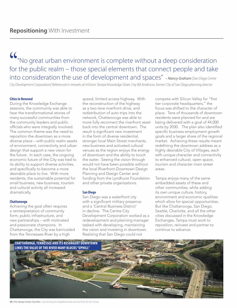
Chattanooga, tennessee and its resurgent downtown links the value of the river many bloCks “uphill”
34 | The Tampa Center City Plan - Connecting Our Neighborhoods and Our River for Our Future
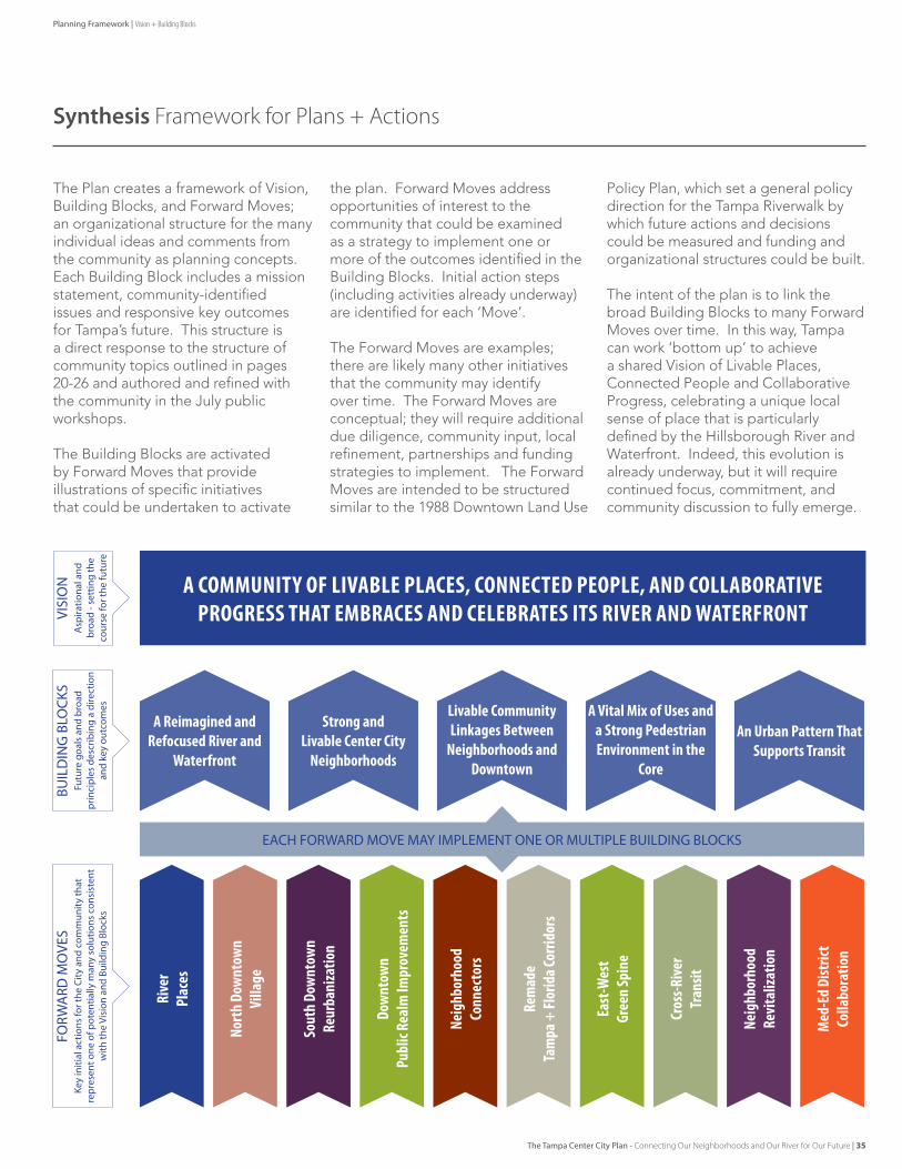
Synthesis Framework for Plans + Actions
The Plan creates a framework of Vision, Building Blocks, and Forward Moves; an organizational structure for the many individual ideas and comments from the community as planning concepts. Each Building Block includes a mission statement, community-identified issues and responsive key outcomes for Tampa’s future. This structure is a direct response to the structure of community topics outlined in pages 20-26 and authored and refined with the community in the July public workshops.
The Building Blocks are activated by Forward Moves that provide illustrations of specific initiatives that could be undertaken to activate
the plan. Forward Moves address opportunities of interest to the community that could be examined as a strategy to implement one or more of the outcomes identified in the Building Blocks. Initial action steps (including activities already underway) are identified for each ‘Move’.
The Forward Moves are examples; there are likely many other initiatives that the community may identify over time. The Forward Moves are conceptual; they will require additional due diligence, community input, local refinement, partnerships and funding strategies to implement. The Forward Moves are intended to be structured similar to the 1988 Downtown Land Use
Policy Plan, which set a general policy direction for the Tampa Riverwalk by which future actions and decisions could be measured and funding and organizational structures could be built.
The intent of the plan is to link the broad Building Blocks to many Forward Moves over time. In this way, Tampa can work ‘bottom up’ to achieve a shared Vision of Livable Places, Connected People and Collaborative Progress, celebrating a unique local sense of place that is particularly defined by the Hillsborough River and Waterfront. Indeed, this evolution is already underway, but it will require continued focus, commitment, and community discussion to fully emerge.
Rive
rPl
aces
Rem
ade
Tam
pa+
Flor
idaC
orrid
ors
Med
-Ed
Dist
rict
Colla
bora
tion
Nort
hDo
wnt
own
Villa
ge
Dow
ntow
nPu
blic
Real
mIm
prov
emen
ts
Cros
s-Rive
rTr
ansit
Sout
hDo
wnt
own
Reur
bani
zatio
n
East
-Wes
tGr
een
Spin
e
Neig
hbor
hood
Conn
ecto
rs
Neig
hbor
hood
Revi
taliz
atio
n
AReimaginedandRefocusedRiverand
Waterfront
ACOMMUNITYOFLIVABLEPLACES,CONNECTEDPEOPLE,ANDCOLLABORATIVEPROGRESSTHATEMBRACESANDCELEBRATESITSRIVERANDWATERFRONT
BUIL
DIN
G B
LOCK
SFO
RWA
RD M
OVE
SVI
SIO
NFu
ture
goa
ls a
nd b
road
pr
inci
ples
des
crib
ing
a di
rect
ion
and
key
outc
omes
Key
initi
al a
ctio
ns fo
r the
City
and
com
mun
ity th
at
repr
esen
t one
of p
oten
tially
man
y so
lutio
ns c
onsi
sten
t w
ith th
e Vi
sion
and
Bui
ldin
g Bl
ocks
Asp
iratio
nal a
nd
broa
d - s
ettin
g th
e co
urse
for t
he fu
ture
StrongandLivableCenterCity
Neighborhoods
AVitalMixofUsesandaStrongPedestrianEnvironmentinthe
Core
LivableCommunityLinkagesBetween
NeighborhoodsandDowntown
AnUrbanPatternThatSupportsTransit
EACH FORWARD MOVE MAY IMPLEMENT ONE OR MULTIPLE BUILDING BLOCKS
Planning Framework | Vision + Building Blocks
The Tampa Center City Plan - Connecting Our Neighborhoods and Our River for Our Future | 35
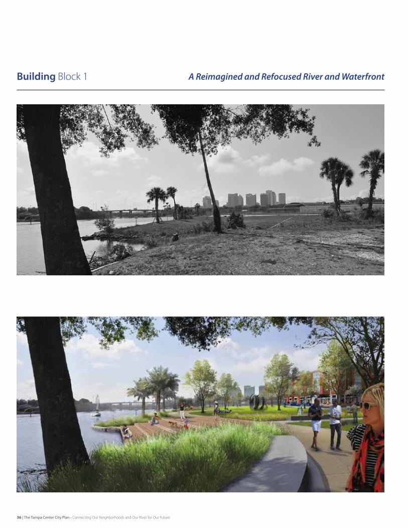
Building block 1 A Reimagined and Refocused River and Waterfront
36 | The Tampa Center City Plan - Connecting Our Neighborhoods and Our River for Our Future
The Hillsborough River and Waterfront will be accessible, comfortable, safe and highly active; extending environmental value into the community through increased connectivity from the neighborhoods and integration with development.
Community-Identified Issues• The Riverwalk makes the river accessible lengthwise, but the amenity and economic value of the “river presence” does not
extend upward into the adjacent community very well. • The Riverwalk is seen as a positive point of connection for the community – one which more people would like to have access to.• Crossing the river on foot or bike is not a pleasant experience.• The Riverwalk has limited types of destinations or “things to do.”• The Riverwalk experience would be more comfortable for more users with additional shade, seating, and amenities.• Water access for boating and recreation is not maximized.• Environmental character and water quality can be enhanced, still many untreated outfalls, litter / debris spots.
Key Outcomes[RW-1]Infrastructure investments and urban planning will work together to extend the value of these waterfront addresses into the adjoining districts and neighborhoods through street and trail connections and enhanced vistas and access points to the river. The riverfront character should extend two or more blocks from the river to create a “River District” beyond the bounds of the Riverwalk.
[RW-2] The Riverwalk trail will be expanded to the West Bank of the river and north to Tampa Heights and West Tampa. Wayfinding and neighborhood access through sidewalks, other trails, and adjacent park spaces will facilitate a more fluid connection to the river from adjacent neighborhoods.
[RW-3]Public access to the river will be at a minimum maintained and ideally enhanced through new development. The way that development integrates with the Riverwalk will be enhanced as the City encourages the retrofit of existing private development to actively engage the Riverwalk through design and placement of retail, restaurants, and other compatible uses along its length. New development that is proposed adjacent to the Riverwalk will be integrated in a similar fashion.
[RW-4] The experience of being next to, on, or nearby the river will be enhanced through thoughtful and persistent activation of the space through enhanced boating facilities and water access points, increased access through services like a water taxi, increased shade and seating opportunities along the Riverwalk, and programmed events at civic venues like Curtis Hixon Park.
[RW-5]The river will be characterized by clean water and a quality, healthy environment. The City will continue to promote Riverwalk and river edge cleanups. New development will incorporate environmental edges along the river and upland improvements to improve water quality before it reaches the river. New water quality retrofits with new and existing outfalls will be pursued.
Planning Framework | Vision + Building Blocks
The Tampa Center City Plan - Connecting Our Neighborhoods and Our River for Our Future | 37
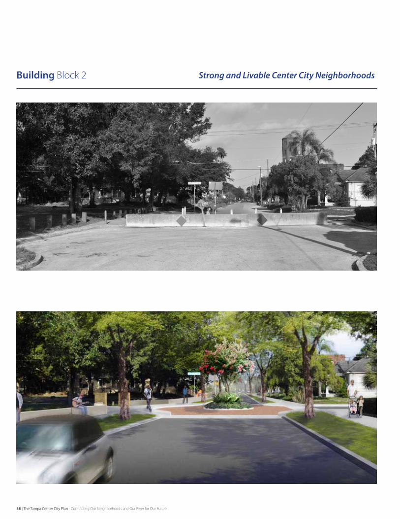
Building block 2 Strong and Livable Center City Neighborhoods
38 | The Tampa Center City Plan - Connecting Our Neighborhoods and Our River for Our Future
The Center City will be made up of vibrant, diverse, distinctive, sustainable, complete, connected, and safe neighborhoods which support multi-generational communities.
Community-Identified Issues• Parks and schools are appreciated neighborhood amenities that residents want to be better physically connected to.• People want to feel safe and secure in their neighborhoods and there are specific crime, social, and infrastructure issues that are
making people feel unsafe and less willing to make long-term investments.• Neighborhood residents want to have daily-needs shopping, services, and restaurants close to home and easily accessible on
foot or by bike. • Residents appreciate new investments in neighborhoods as long as they are compatible with the historic scale and character of
the neighborhood.
Key Outcomes[NH-1]The City will continue to support the neighborhood planning process and leverage the process to define infrastructure investments that improve neighborhood livability and quality of life for all residents such as utilities enhancement and sidewalks, street trees, and bicycle facilities.
[NH-2]Neighborhood parks will be improved and enhanced and will be made more easily and safely accessible to the community through enhancee local connections including sidewalks, crossings, underpasses and bikeways.
[NH-3]Center City neighborhoods will be places that homeowners and entrepreneurs want to make investments in residential and neighborhood-support retail and office uses. The City will work to improve the attractiveness of neighborhoods for this investment through retail incentives, business friendly development services, and targeted user recruitment (e.g., grocery stores), and through expanded housing investment incentives.
[NH-4]Center City neighborhoods will have design standards for infill development that respects historic patterns, architecture, and local historic designations.
[NH-5]The City will continue to enhance community safety through organizational support.
[NH-6]Each neighborhood will have access to strong primary and secondary schools.
[NH-7]The City will support neighborhoods to develop branding that is related to their history and context.
Planning Framework | Vision + Building Blocks
The Tampa Center City Plan - Connecting Our Neighborhoods and Our River for Our Future | 39
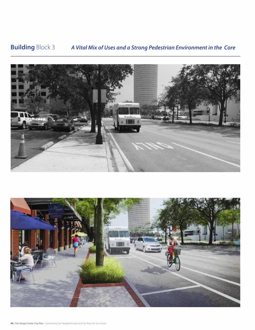
Building block 3 A Vital Mix of Uses and a Strong Pedestrian Environment in the Core
40 | The Tampa Center City Plan - Connecting Our Neighborhoods and Our River for Our Future
The Downtown Core will be repositioned as a more attractive and accessible local place for people to live, work and play while supporting growing regional employment, cultural, healthcare and academic attractors with an improved public realm to support a viable downtown village.
Community-Identified Issues• Downtown is primarily an office location with regional cultural and entertainment facilities and a small bit of residential – should
this model change to encourage a place with significantly more residents while still enhancing the other current uses?• Access into and out of downtown is difficult and disorienting, particularly for visitors. • Downtown’s walking environment is not good in part because Downtown’s streets are geared to serve peak flows of cars and are
not “complete streets” that serve pedestrians, bikes, transit, and cars.• A large portion of Downtown contains surface parking lots, “super blocks”, and industrial uses that create “holes” in the pattern of
streets and blocks.• There are potential partnerships that could reshape large areas – how can this condition be nurtured?
Key Outcomes[DC-1]Downtown will see investments in infrastructure and services to support a significant residential infill movement. This will involve improved access to retail and daily needs services, improved transit circulation, focused residentially-oriented open space amenities, strong primary and secondary schools, and a balance between local character and regional activity.
[DC-2]The Downtown Core will have the highest quality pedestrian environment in the region created through a focus on complete streets, transit accessibility, and linkages to the regional trail system.
[DC-3]Downtown will continue to deliver a diverse set of regional attractors, such as higher education, healthcare, tourism, culture and entertainment, finance, legal, hi-tech, port and shipping, and military through facilitation of development, job training, and business incubation. New businesses will be attracted to better urbanism – new business wants to be in places that are interesting, connected, lively, and livable for their employees and customers.
[DC-4]Infrastructure Downtown will be rebalanced to support the new mixed use vision. This will take the form of upgraded utilities and drainage capacity, livable streets and mobility choices, enhanced parks and open space, and transportation choices.
Planning Framework | Vision + Building Blocks
The Tampa Center City Plan - Connecting Our Neighborhoods and Our River for Our Future | 41
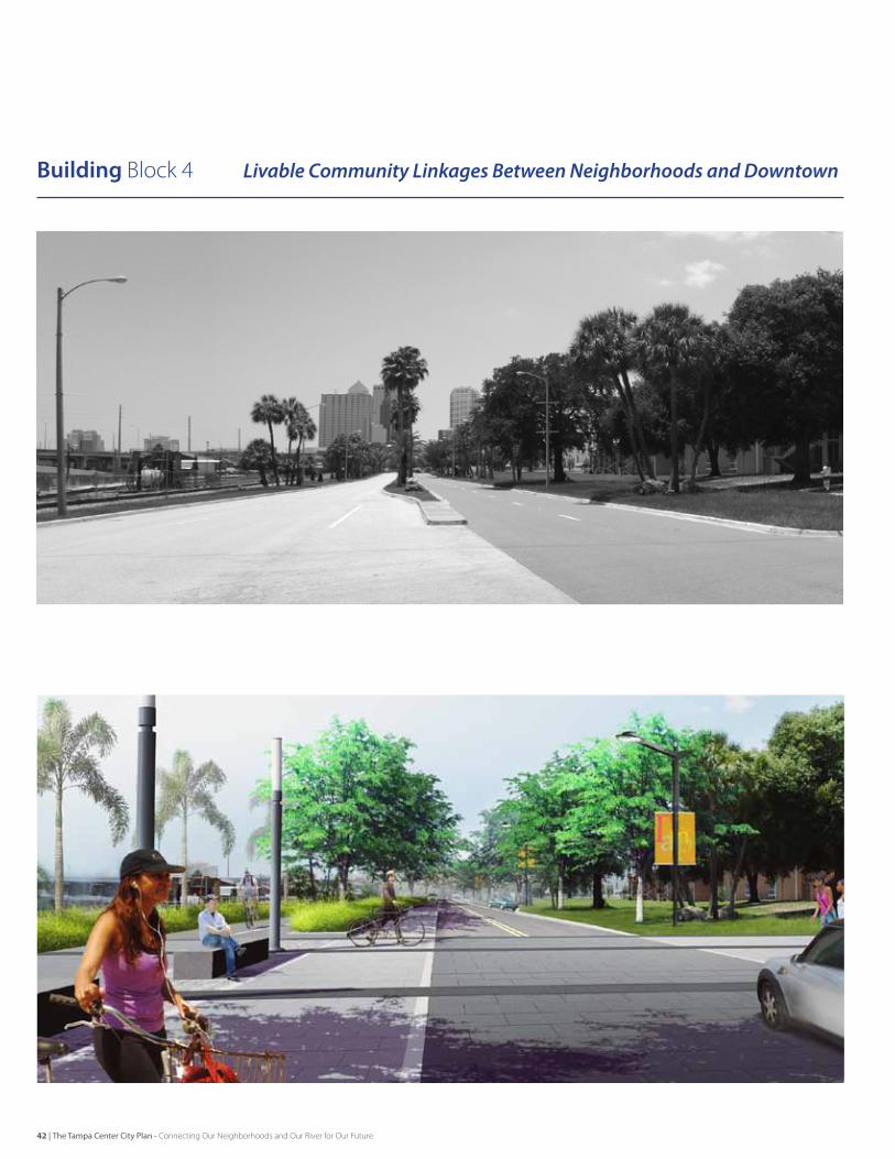
Building block 4 Livable Community Linkages Between Neighborhoods and Downtown
42 | The Tampa Center City Plan - Connecting Our Neighborhoods and Our River for Our Future
Center City streets will be neighborhood-focused, connected and calm, create the environment for new businesses, and will promote safe pedestrian activity.
Community-Identified Issues• Places that are close by feel far away because of the harsh walking environment.• Large roads and freeway ramps isolate key community destinations and neighborhoods.• While some streets have been addressed, getting to key neighborhood and community destinations on a bike is not safe or easy.• The trail system is expanding, but connectivity to adjacent neighborhoods could allow more people to utilize non-motorized
modes of travel and better connect neighborhoods with each other and the Downtown Core.• Trips through Center City are made easy at the expense of the surrounding neighborhoods and retail nodes.
Key Outcomes[CL-1]The status of walking and bicycling will be elevated in the Center City. The number of walking and cycling routes within Center City will be increased as will access to the waterfront, the island neighborhoods, and regional trail facilities.
[CL-2] Roadways carrying areawide traffic through neighborhoods and neighborhood centers (such as Cass/Nuccio, Florida, Tampa, Howard, Armenia, Avenue Republica de Cuba) will be restructured as livable streets that balance the needs of vehicular users, non-motorized users, and the community in which they occur.
[CL-3]Overly wide streets will be examined for “road diets” and streetscape enhancements to right-size the facility to its community purpose.
[CL-4]One-way streets will be re-evaluated with performance measures that consider traffic operations as well as the impact of the street conditions on adjacent residents and businesses. Some streets may be candidates for conversion to two-way operations. [CL-5] To clearly outline expectations for the future condition of the public realm, especially streets, design standards will be developed to address the creation of a pedestrian-friendly private development edge to the public realm.
Planning Framework | Vision + Building Blocks
The Tampa Center City Plan - Connecting Our Neighborhoods and Our River for Our Future | 43
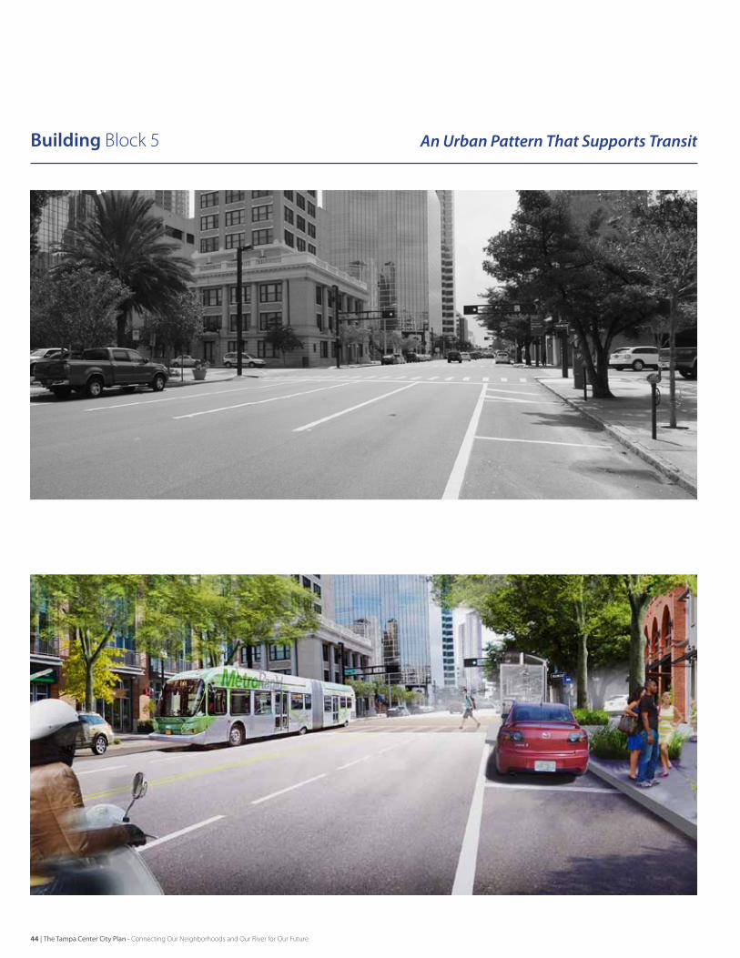
Building block 5 An Urban Pattern That Supports Transit
44 | The Tampa Center City Plan - Connecting Our Neighborhoods and Our River for Our Future
vibrant Center City neighborhoods will be connected to one another and to regional destinations with multi-modal transit that is well-funded, frequent, dependable, user-friendly, and progressive.
Community-Identified Issues• Transit is not seen as a viable transportation option by “choice” riders.• A broad element of the community wants transit to be an effective means of transportation, but there are not enough people or
places of density and activity to support transit across the Center City.• The streetcar functions more as a tourist attraction that does not effectively serve the local population.• There is no perceived easy and effective local circulator getting people around the Downtown Core.• There are destinations outside the Center City that people want to be connected to by means other than automobile.
Key Outcomes[TR-1]The Center City will recognize, and create urban planning strategies that respond to, the specific transportation function and city-building roles (within the State, Region, and Center City) of varying transit modes.
[TR-2] The Center City will build places with densities that support effective transit service and capitalize on current growth centers like the Channel District, the Downtown Core, and North Hyde Park/UT with an east-west transit route to capture choice riders.
[TR-3] The City will facilitate the incorporation of transit-supportive policies into all levels of policy guidance.
[TR-4] The City will advocate regional partnership solidarity on transit, with a unified plan, a clear message of regional and local benefits, and will work to identify and secure funding with community champions.
[TR-5]Center City will have branded, updated transit alternatives that can build momentum for other improvements. This will include a funding source for the streetcar, the initiation of MetroRapid service, the expansion of the Marion Street Transit Center, and an updated east-west transit circulator as a precursor to future rail transit.
Planning Framework | Vision + Building Blocks
The Tampa Center City Plan - Connecting Our Neighborhoods and Our River for Our Future | 45
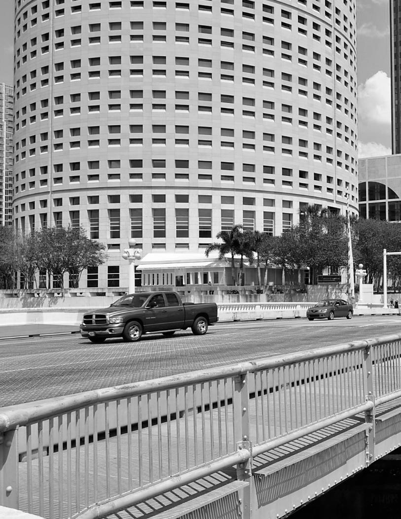
Ten Forward moves
Implementing the Framework
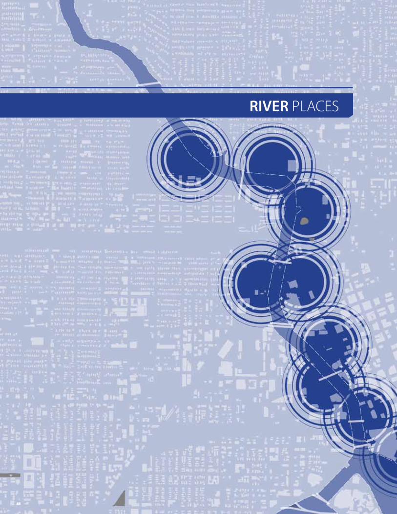
RIVER PLACeS
48
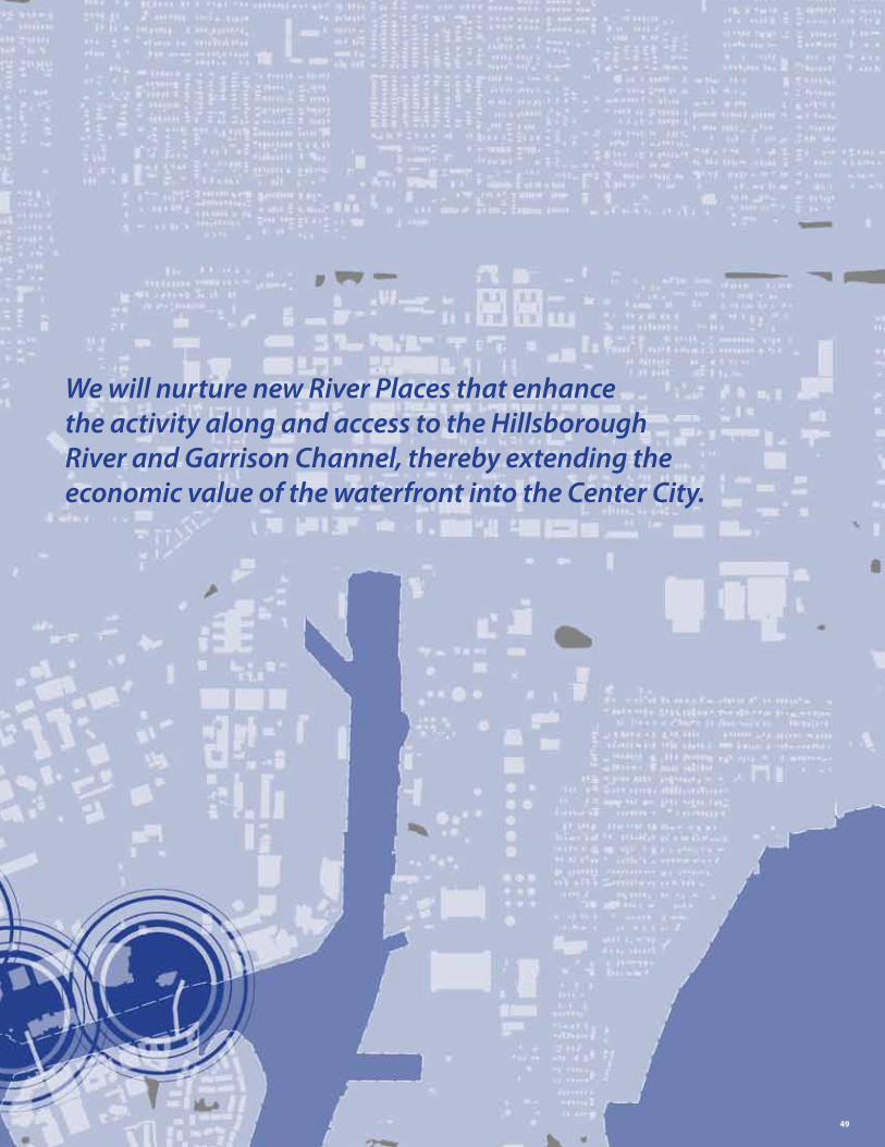
We will nurture new River Places that enhance the activity along and access to the Hillsborough River and Garrison Channel, thereby extending the economic value of the waterfront into the Center City.
49
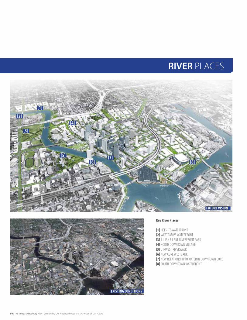
KeyRiverPlaces
[1] HeIgHTS WaTerFronT[2]WeST TaMPa WaTerFronT[3] julIan B lane rIVerFronT Park[4] norTH doWnToWn VIllage[5] uT/WeST rIVerWalk[6] neW Core WeSTBank[7] neW relaTIonSHIP To WaTer In doWnToWn Core[8] SouTH doWnToWn WaTerFronT
existing conditions
Future Vision
[1]
[2]
[3]
[4]
[5][6]
[7][8]
RIVER PLACeS
50 | The Tampa Center City Plan - Connecting Our Neighborhoods and Our River for Our Future
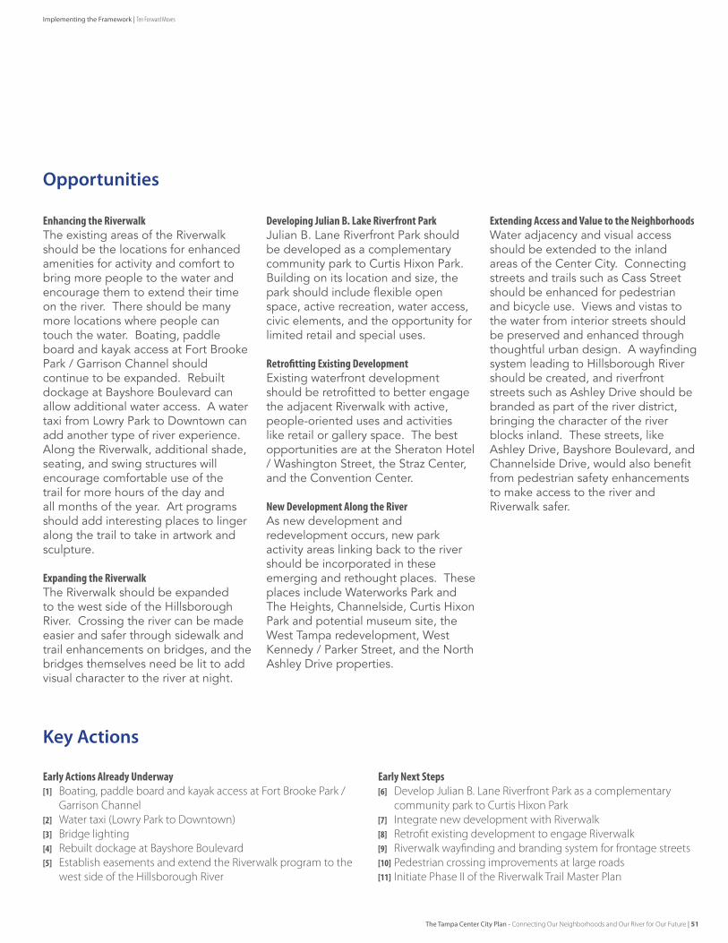
EarlyActionsAlreadyUnderway[1] boating, paddle board and kayak access at Fort brooke Park /
Garrison Channel[2] Water taxi (Lowry Park to Downtown)[3] bridge lighting[4] Rebuilt dockage at bayshore boulevard[5] establish easements and extend the Riverwalk program to the
west side of the Hillsborough River
EarlyNextSteps[6] Develop Julian b. Lane Riverfront Park as a complementary
community park to Curtis Hixon Park[7] Integrate new development with Riverwalk[8] Retrofit existing development to engage Riverwalk[9] Riverwalk wayfinding and branding system for frontage streets[10] Pedestrian crossing improvements at large roads[11] Initiate Phase II of the Riverwalk Trail master Plan
Opportunities
Key Actions
EnhancingtheRiverwalkThe existing areas of the riverwalk should be the locations for enhanced amenities for activity and comfort to bring more people to the water and encourage them to extend their time on the river. There should be many more locations where people can touch the water. Boating, paddle board and kayak access at fort Brooke Park / garrison Channel should continue to be expanded. rebuilt dockage at Bayshore Boulevard can allow additional water access. A water taxi from lowry Park to downtown can add another type of river experience. Along the riverwalk, additional shade, seating, and swing structures will encourage comfortable use of the trail for more hours of the day and all months of the year. Art programs should add interesting places to linger along the trail to take in artwork and sculpture.
ExpandingtheRiverwalkThe riverwalk should be expanded to the west side of the Hillsborough river. Crossing the river can be made easier and safer through sidewalk and trail enhancements on bridges, and the bridges themselves need be lit to add visual character to the river at night.
DevelopingJulianB.LakeRiverfrontParkJulian B. lane riverfront Park should be developed as a complementary community park to Curtis Hixon Park. Building on its location and size, the park should include flexible open space, active recreation, water access, civic elements, and the opportunity for limited retail and special uses.
RetrofittingExistingDevelopmentexisting waterfront development should be retrofitted to better engage the adjacent riverwalk with active, people-oriented uses and activities like retail or gallery space. The best opportunities are at the sheraton Hotel / Washington street, the straz Center, and the Convention Center.
NewDevelopmentAlongtheRiverAs new development and redevelopment occurs, new park activity areas linking back to the river should be incorporated in these emerging and rethought places. These places include Waterworks Park and The Heights, Channelside, Curtis Hixon Park and potential museum site, the West Tampa redevelopment, West kennedy / Parker street, and the North Ashley drive properties.
ExtendingAccessandValuetotheNeighborhoodsWater adjacency and visual access should be extended to the inland areas of the Center City. Connecting streets and trails such as Cass street should be enhanced for pedestrian and bicycle use. views and vistas to the water from interior streets should be preserved and enhanced through thoughtful urban design. A wayfinding system leading to Hillsborough river should be created, and riverfront streets such as Ashley drive should be branded as part of the river district, bringing the character of the river blocks inland. These streets, like Ashley drive, Bayshore Boulevard, and Channelside drive, would also benefit from pedestrian safety enhancements to make access to the river and riverwalk safer.
The Tampa Center City Plan - Connecting Our Neighborhoods and Our River for Our Future | 51
Implementing the Framework | Ten Forward Moves
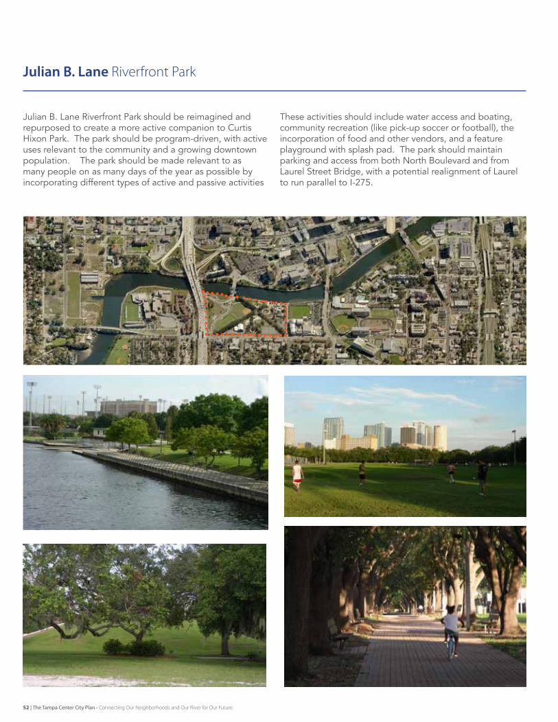
Julian B. lane riverfront Park should be reimagined and repurposed to create a more active companion to Curtis Hixon Park. The park should be program-driven, with active uses relevant to the community and a growing downtown population. The park should be made relevant to as many people on as many days of the year as possible by incorporating different types of active and passive activities
These activities should include water access and boating, community recreation (like pick-up soccer or football), the incorporation of food and other vendors, and a feature playground with splash pad. The park should maintain parking and access from both North Boulevard and from laurel street Bridge, with a potential realignment of laurel to run parallel to I-275.
Julian B. Lane Riverfront Park
52 | The Tampa Center City Plan - Connecting Our Neighborhoods and Our River for Our Future
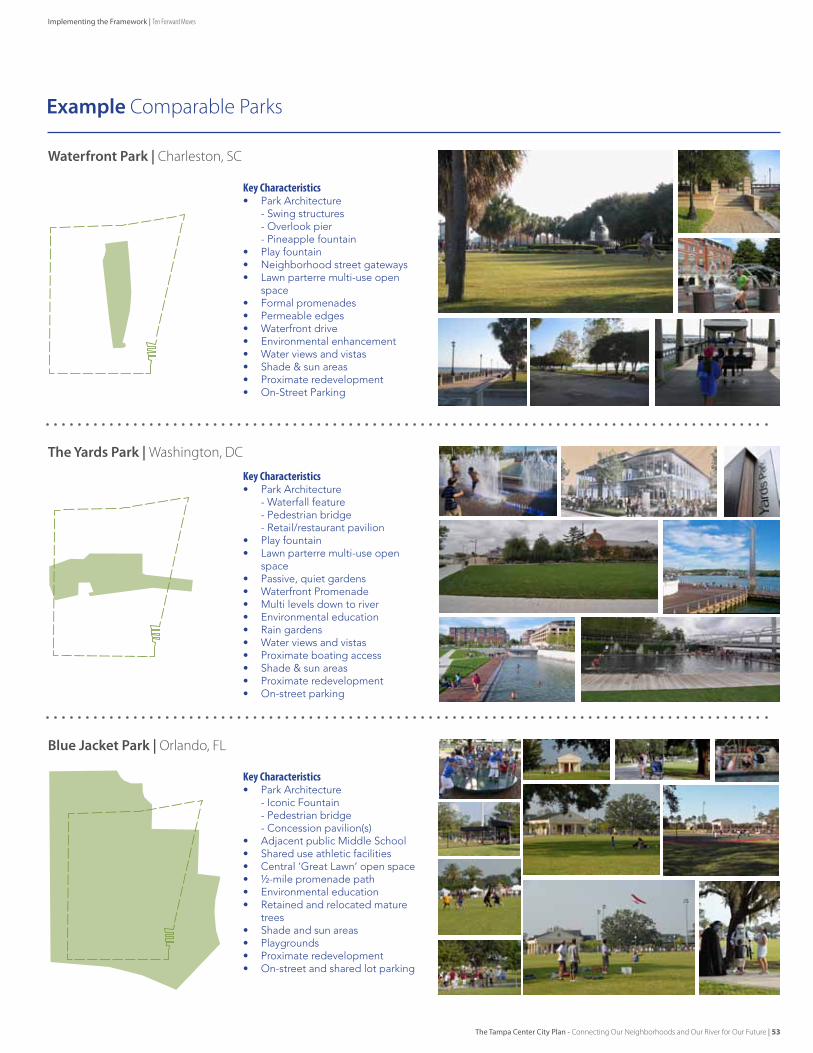
Example Comparable Parks
Waterfront Park | Charleston, SC
The yards Park | Washington, DC
Blue Jacket Park | Orlando, FL
KeyCharacteristics• Park Architecture - Iconic Fountain - Pedestrian bridge - Concession pavilion(s)• Adjacent public Middle School• Shared use athletic facilities• Central ‘Great Lawn’ open space• ½-mile promenade path • Environmental education• Retained and relocated mature
trees• Shade and sun areas• Playgrounds• Proximate redevelopment• On-street and shared lot parking
KeyCharacteristics• Park Architecture - Waterfall feature - Pedestrian bridge - Retail/restaurant pavilion• Play fountain • Lawn parterre multi-use open
space• Passive, quiet gardens• Waterfront Promenade• Multi levels down to river• Environmental education• Rain gardens• Water views and vistas• Proximate boating access• Shade & sun areas• Proximate redevelopment• On-street parking
KeyCharacteristics• Park Architecture - Swing structures - Overlook pier - Pineapple fountain• Play fountain• Neighborhood street gateways• Lawn parterre multi-use open
space• Formal promenades• Permeable edges• Waterfront drive • Environmental enhancement• Water views and vistas• Shade & sun areas• Proximate redevelopment• On-Street Parking
The Tampa Center City Plan - Connecting Our Neighborhoods and Our River for Our Future | 53
Implementing the Framework | Ten Forward Moves
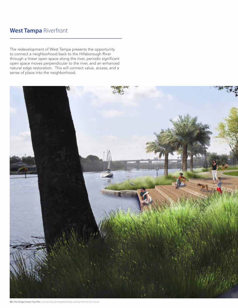
West Tampa Riverfront
The redevelopment of West Tampa presents the opportunity to connect a neighborhood back to the Hillsborough river through a linear open space along the river, periodic significant open space moves perpendicular to the river, and an enhanced natural edge restoration. This will connect value, access, and a sense of place into the neighborhood.
54 | The Tampa Center City Plan - Connecting Our Neighborhoods and Our River for Our Future
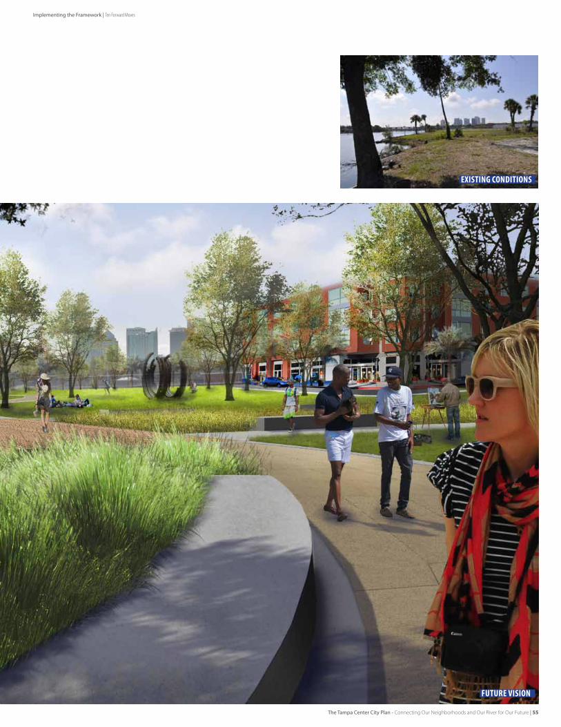
existing conditions
FUTURE VISION
The Tampa Center City Plan - Connecting Our Neighborhoods and Our River for Our Future | 55
Implementing the Framework | Ten Forward Moves
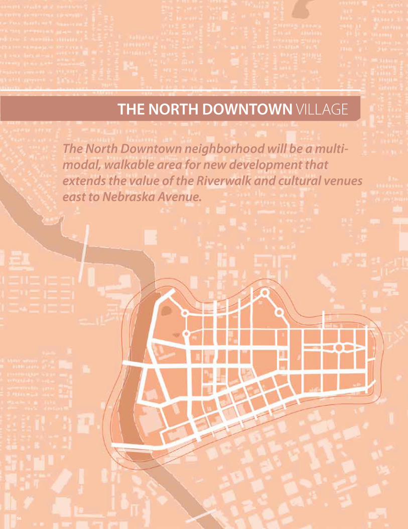
THE NORTH DOWNTOWN vILLAGe
The North Downtown neighborhood will be a multi-modal, walkable area for new development that extends the value of the Riverwalk and cultural venues east to Nebraska Avenue.
56
57
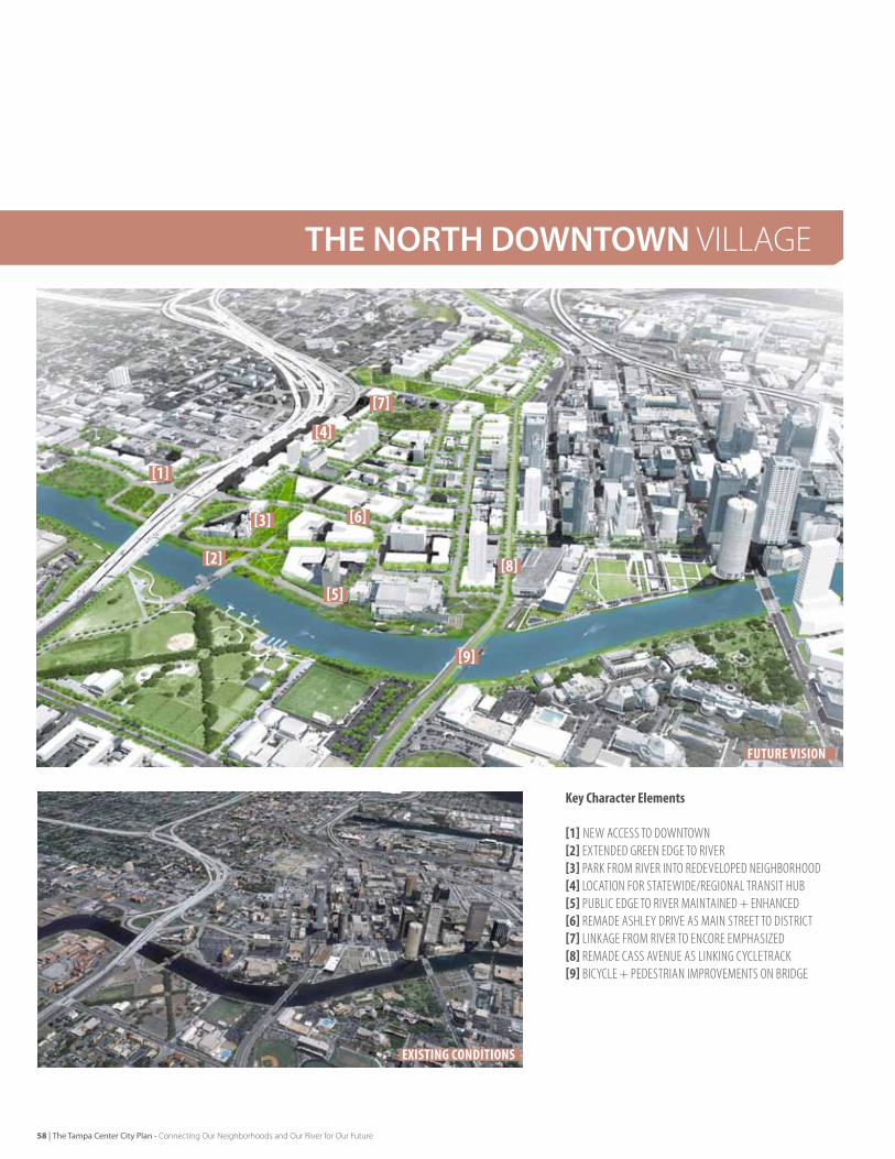
KeyCharacterElements
[1] neW aCCeSS To doWnToWn[2]exTended green edge To rIVer[3] Park FroM rIVer InTo redeVeloPed neIgHBorHood[4] loCaTIon For STaTeWIde/regIonal TranSIT HuB[5] PuBlIC edge To rIVer MaInTaIned + enHanCed[6] reMade aSHley drIVe aS MaIn STreeT To dISTrICT[7] lInkage FroM rIVer To enCore eMPHaSIzed[8] reMade CaSS aVenue aS lInkIng CyCleTraCk[9] BICyCle + PedeSTrIan IMProVeMenTS on BrIdge
existing conditions
Future Vision
[1]
[7]
[8]
[9]
[4]
[3]
[5]
[2]
[6]
THE NORTH DOWNTOWN vILLAGe
58 | The Tampa Center City Plan - Connecting Our Neighborhoods and Our River for Our Future
EarlyActionsAlreadyUnderway[1] Preserve opportunity for future multi-modal/high-speed rail site[2] enhance Perry Harvey Park
EarlyNextSteps[3] Request THeA to evaluate their toll strategy to discourage
downtown cut-through traffic.[4] Identify interim uses for FDOT property at future rail site[5] Convert Tyler and Cass Streets to two-way function[6] examine the Library Annex as a redevelopment site[7] examine properties around Straz Center for coordinated
development with shared parking[8] Identify ‘sparkle’ retail for properties around Straz Center and
Curtis Hixon Park
Opportunities
Key Actions
LinkingtheCommunityThroughInfillThe North downtown should be the site of significant infill development on opportunity sites around the straz Center, including surface parking lots throughout the district. This development will be linked back to the river through a series of green spaces creating riverwalk access blocks into the neighborhood. These opportunities are significant because of the nature of the parcelization in the area – several large parcels, many of which are under public ownership.
ImprovingDowntownAccessIn order to fully maximize the connection to the river, the access pattern into and out of downtown should be reworked to allow for a reduction in speed and size of Ashley drive and Jefferson street. The impact of expressway ramps leading deep into downtown should be removed, and access should strive to quickly disperse traffic rather than focusing it on one or two locations. This idea is ideally implemented with major infrastructure investments in the area – either for rail or the interstate.
PreservingMulti-ModalTransitAccessAs development occurs, the plans should preserve the opportunity for multi-modal transit access (for example statewide rail, regional rail, and a link to downtown transit circulators) on the blocks adjacent to the current transit center. In the meantime, interim uses for this site, such as community gardens or passive open space, should be identified and implemented so as not to impact community cohesion with a lingering undeveloped site.
CreatingOpenSpaceLinkagesIn order to link the area to its surroundings, Cass and Tyler streets should be converted to two-way function, with enhanced streetscape and bike facilities to promote access to and across the Hillsborough river. These improvements should work in concert with an enhancement to Perry Harvey Park as an open space address for encore and other area residential areas. Walkability should be enhanced to allow soft connections to Tampa Heights and access from encore to the riverwalk. To the northeast, efforts should continue to seek ways to improve the connection and linkage to Ybor City and vM Ybor through infill development and improvements to the street network.
The Tampa Center City Plan - Connecting Our Neighborhoods and Our River for Our Future | 59
Implementing the Framework | Ten Forward Moves
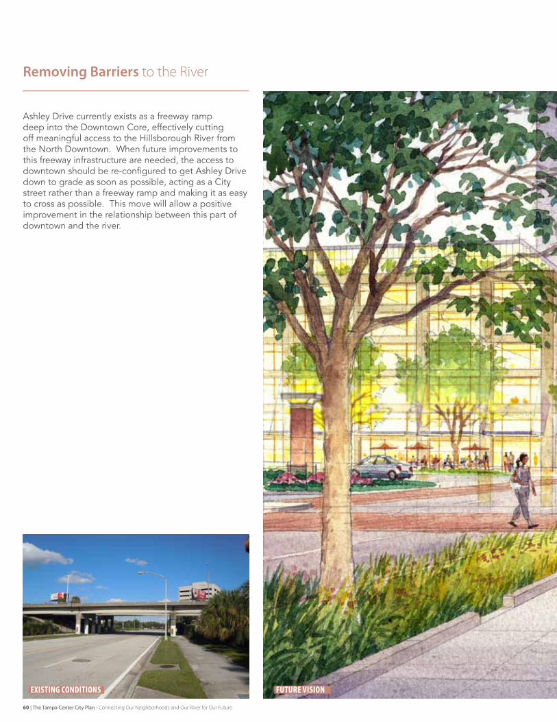
Ashley drive currently exists as a freeway ramp deep into the downtown Core, effectively cutting off meaningful access to the Hillsborough river from the North downtown. When future improvements to this freeway infrastructure are needed, the access to downtown should be re-configured to get Ashley drive down to grade as soon as possible, acting as a City street rather than a freeway ramp and making it as easy to cross as possible. This move will allow a positive improvement in the relationship between this part of downtown and the river.
Removing Barriers to the River
existing conditions Future Vision
60 | The Tampa Center City Plan - Connecting Our Neighborhoods and Our River for Our Future
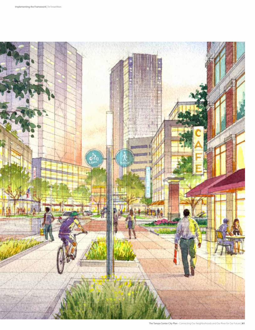
The Tampa Center City Plan - Connecting Our Neighborhoods and Our River for Our Future | 61
Implementing the Framework | Ten Forward Moves
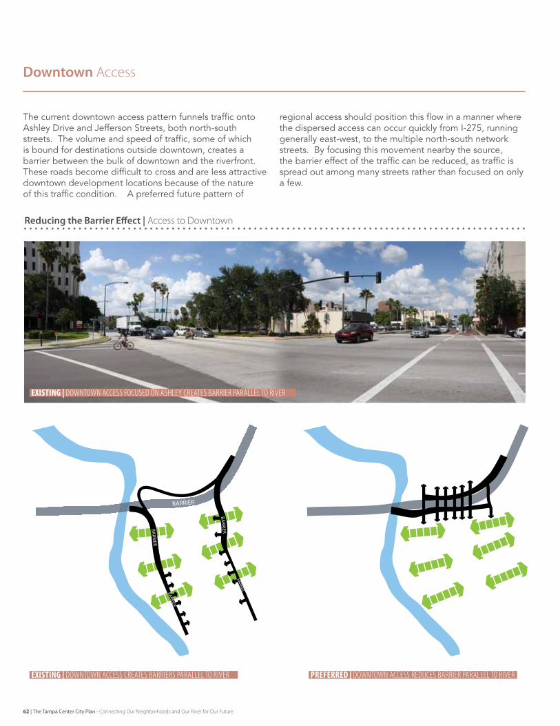
Reducing the Barrier Effect | Access to Downtown
The current downtown access pattern funnels traffic onto Ashley drive and Jefferson streets, both north-south streets. The volume and speed of traffic, some of which is bound for destinations outside downtown, creates a barrier between the bulk of downtown and the riverfront. These roads become difficult to cross and are less attractive downtown development locations because of the nature of this traffic condition. A preferred future pattern of
regional access should position this flow in a manner where the dispersed access can occur quickly from I-275, running generally east-west, to the multiple north-south network streets. By focusing this movement nearby the source, the barrier effect of the traffic can be reduced, as traffic is spread out among many streets rather than focused on only a few.
Downtown Access
BARRIER
BARRIER
BARRIER
BARRIER
BARRIER
existing | downtown access creates barriers parallel to river
existing | downtown access FocUsed on asHLeY creates barrier paraLLeL to river
preferred | downtown access reduces barrier parallel to river
62 | The Tampa Center City Plan - Connecting Our Neighborhoods and Our River for Our Future
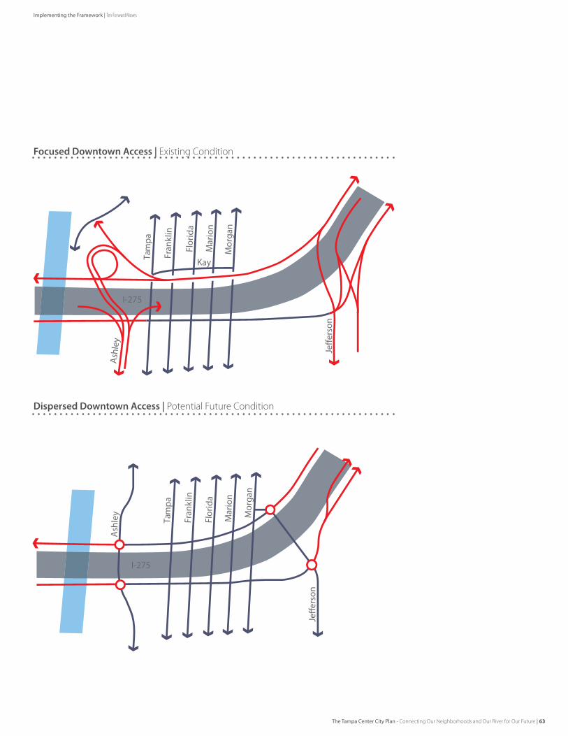
I-275
Tam
pa
Ash
ley
Fran
klin
Flor
ida
Mar
ion
Mor
gan
Kay
I-275
Tam
pa
Ash
ley
Fran
klin
Flor
ida
Mar
ion
Mor
gan
Dispersed Downtown Access | Potential Future Condition
Focused Downtown Access | existing Condition
The Tampa Center City Plan - Connecting Our Neighborhoods and Our River for Our Future | 63
Implementing the Framework | Ten Forward Moves
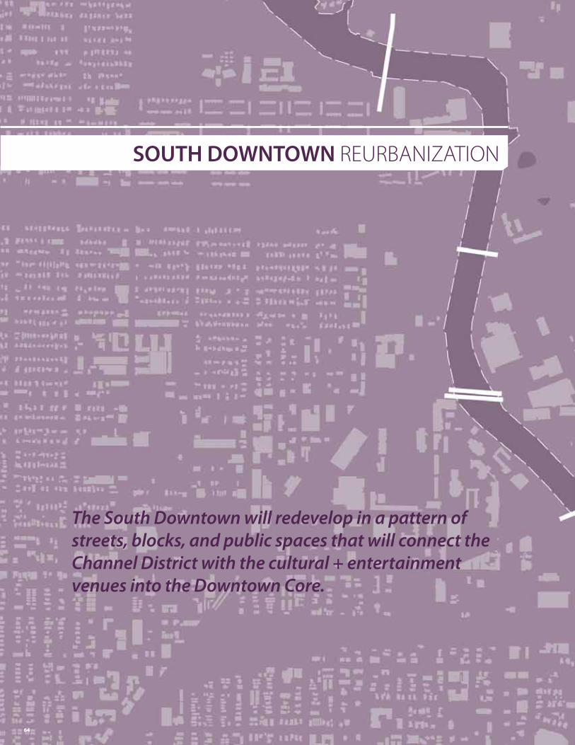
SOUTH DOWNTOWN ReURbANIZATION
The South Downtown will redevelop in a pattern of streets, blocks, and public spaces that will connect the Channel District with the cultural + entertainment venues into the Downtown Core.
64
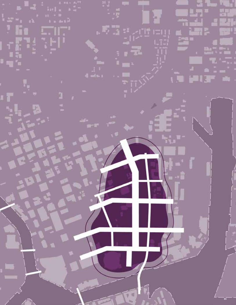
65
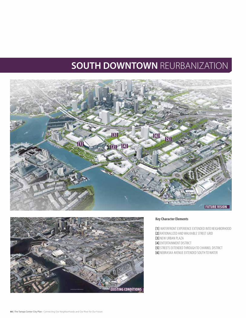
SOUTH DOWNTOWN ReURbANIZATION
KeyCharacterElements
[1] WaTerFronT exPerIenCe exTended InTo neIgHBorHood[2]raTIonalIzed and WalkaBle STreeT grId[3] neW urBan Plaza[4] enTerTaInMenT dISTrICT[5] STreeTS exTended THrougH To CHannel dISTrICT[6] neBraSka aVenue exTended SouTH To WaTer
existing conditions
Future Vision
[1] [4]
[3][5]
[2]
[6]
66 | The Tampa Center City Plan - Connecting Our Neighborhoods and Our River for Our Future
CreatingaSeamDowntownThe south downtown area is positioned to be the link between the downtown Core and the Channel district. While the pace of redevelopment is uncertain, the outcome should not be. This area should be reurbanized, with a connected street grid rather than a focus on highway access, a mix of uses rather than large blocks of single uses,
ReconfiguringtheStreetGrid The street grid in the south downtown should be reconciled to better connect the downtown Core to the Channel district and the Times forum to the Nebraska corridor on the north. This grid should be created through the redevelopment of key sites in the district. The normalization of the block structure in this manner can create more efficient and developable blocks. examples of these grid improvements include the connection of Cumberland Avenue, the southern extension of Nebraska Avenue, and the redesign of the Brorein street angle.
AccommodatingthePedestrianThe large roads in south downtown should be made more pedestrian-friendly. Their current configuration is focused on efficiently moving vehicles before and after events. during the remainder of the day, year-round, this configuration creates a condition which compromises pedestrian safety and comfort. vehicular priority moves like slip lanes and lengthy dedicated turn lanes should be re-evaluated for their impact on the pedestrian environment. Meridian Avenue should be made easier to cross through future pedestrian intersections on Washington and Whiting streets. Pedestrian crossing enhancements should be made at current intersections along Meridian Avenue and kennedy Boulevard, and new streetscape should remake Channelside drive in the vicinity of the Times forum.
InfillingtheBlocksMixed-use infill development around the Tampa Bay Times forum should include entertainment, retail, and residential uses. The Channelside retail venue should be repositioned in the market with a new tenant mix, and physically opened to Channelside drive and garrison Channel. Its future should be contemplated along with potential hotel and mixed-use development sites adjacent to the venue.
CreatingNewPublicSpacesPublic open spaces in south downtown should be enhanced and built upon to drive value for development in the district. These public realm improvements should include enhanced water arrival and amenities at fort Brooke Park, a robust trail system on west Meridian Avenue and a trail under the selmon expressway connecting the riverwalk to a sr 60 regional trail.
When the area north of the Tampa Bay Times forum is developed, it should work within a re-worked block structure, leveraging the efficiencies of the regular blocks and livable street system to include a significant open space in front of Tampa Bay Times forum.
In the Channel district, an additional neighborhood park or square in on kennedy Boulevard would give focus to the emergence of that area as the northern anchor to the district and an eastern anchor to downtown. further, 11th and 12th streets should be enhanced and reinforced as mixed-use neighborhood streets linking residents, employees, and visitors to this new park.
EarlyActionsAlreadyUnderway[1] Reposition the Channelside retail center[2] Secure easement for Cumberland Avenue connection[3] Continue infill residential in the Channel District
EarlyNextSteps[4] Connect Cumberland Avenue across meridian[5] Remove slip lanes at Channelside Drive / meridian [6] Develop a new Channelside Drive streetscape [7] Remove brorein Street Angle and connect grid with property
assembly[8] Recruit grocery and other community-serving retail[9] Support redevelopment and activity initiatives along
Channelside Drive and Water Street
Opportunities
Key Actions
The Tampa Center City Plan - Connecting Our Neighborhoods and Our River for Our Future | 67
Implementing the Framework | Ten Forward Moves
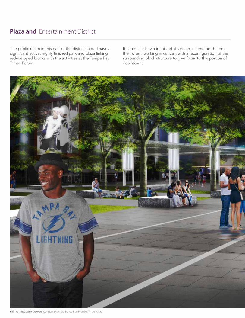
Plaza and entertainment District
The public realm in this part of the district should have a significant active, highly finished park and plaza linking redeveloped blocks with the activities at the Tampa Bay Times forum.
It could, as shown in this artist’s vision, extend north from the forum, working in concert with a reconfiguration of the surrounding block structure to give focus to this portion of downtown.
68 | The Tampa Center City Plan - Connecting Our Neighborhoods and Our River for Our Future
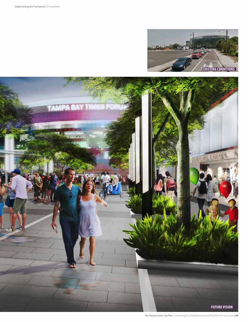
existing conditions
Future Vision
The Tampa Center City Plan - Connecting Our Neighborhoods and Our River for Our Future | 69
Implementing the Framework | Ten Forward Moves
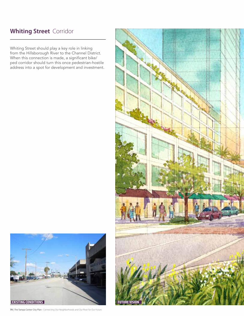
Whiting street should play a key role in linking from the Hillsborough river to the Channel district. When this connection is made, a significant bike/ped corridor should turn this once pedestrian-hostile address into a spot for development and investment.
Whiting Street Corridor
existing conditions Future Vision
70 | The Tampa Center City Plan - Connecting Our Neighborhoods and Our River for Our Future
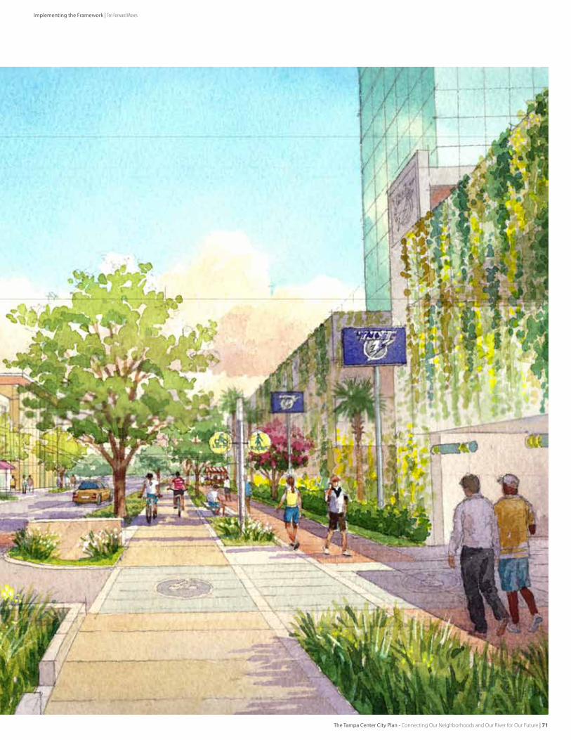
The Tampa Center City Plan - Connecting Our Neighborhoods and Our River for Our Future | 71
Implementing the Framework | Ten Forward Moves
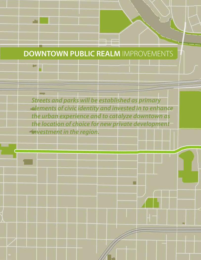
DOWNTOWN PUBLIC REALM ImPROvemeNTS
Streets and parks will be established as primary elements of civic identity and invested in to enhance the urban experience and to catalyze downtown as the location of choice for new private development investment in the region.
72
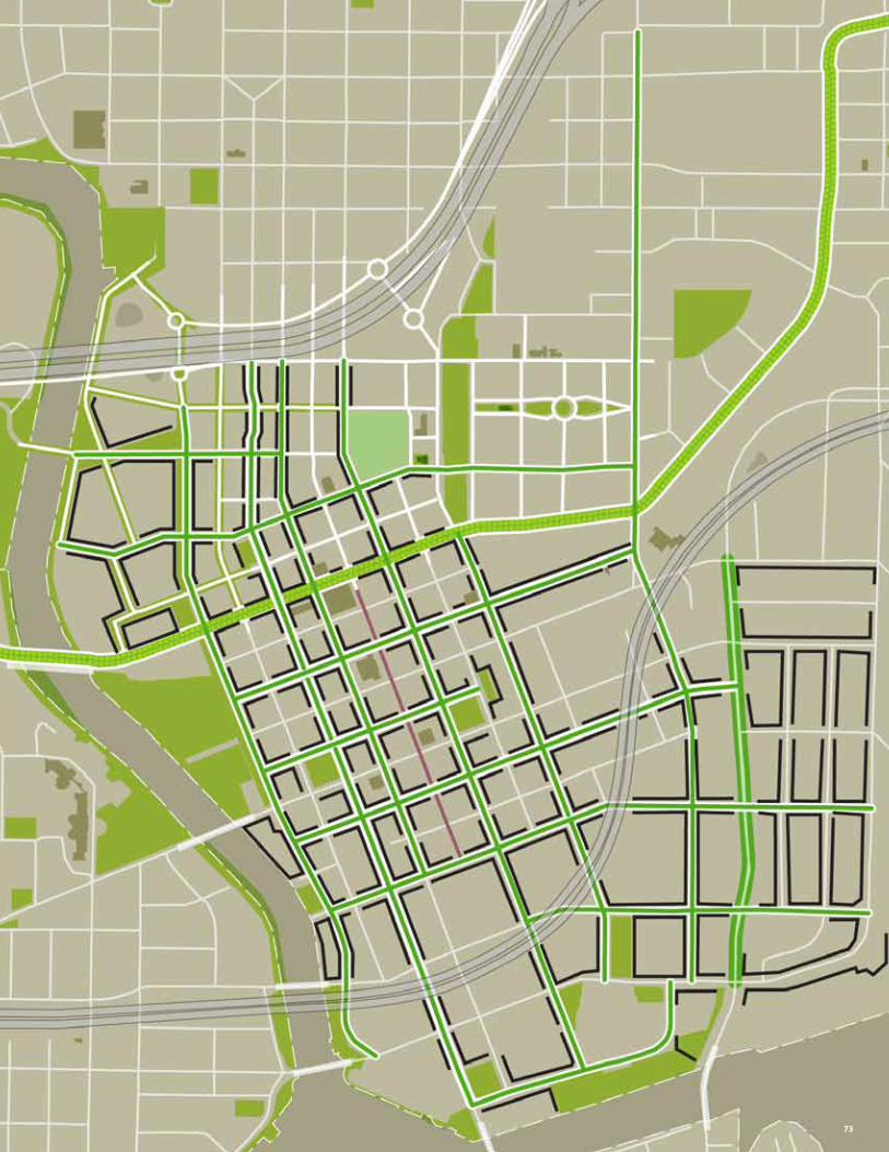
73
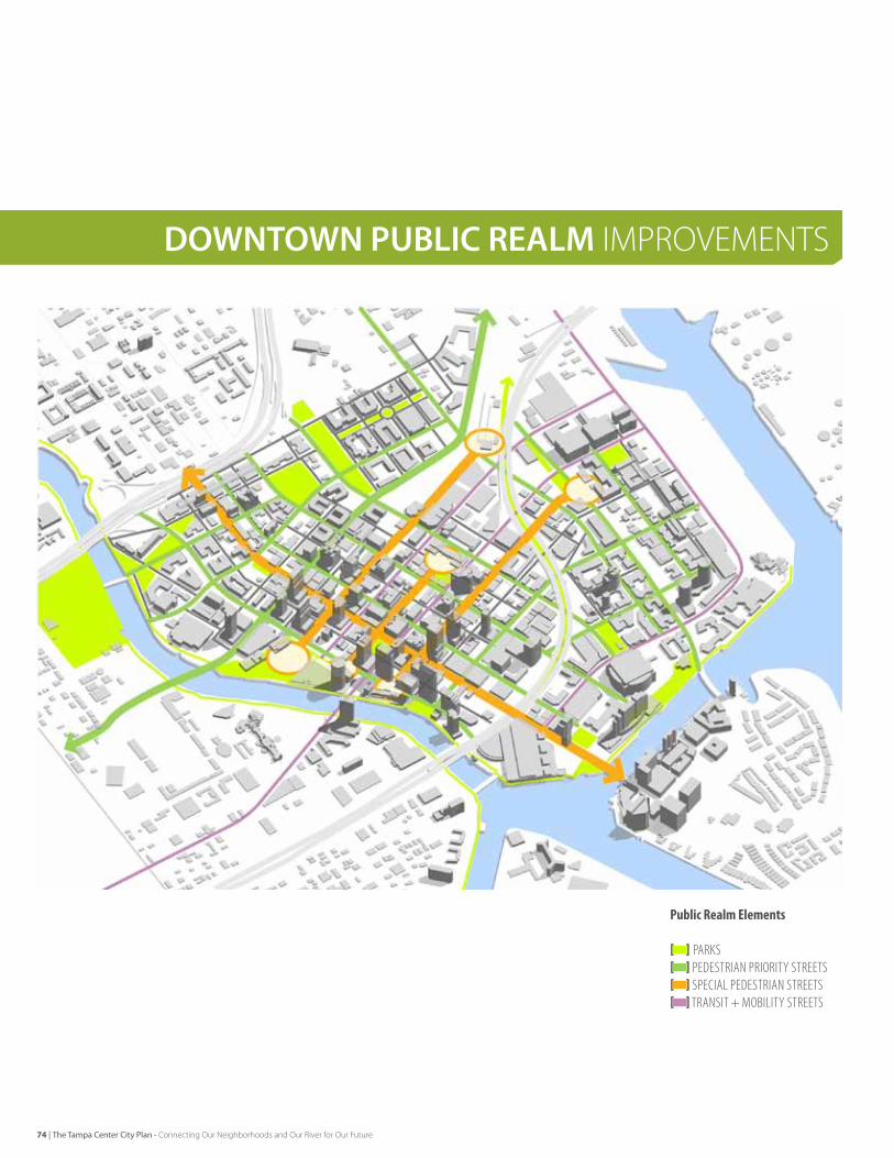
DOWNTOWN PUBLIC REALM ImPROvemeNTS
PublicRealmElements
[] ParkS[]PedeSTrIan PrIorITy STreeTS[] SPeCIal PedeSTrIan STreeTS[] TranSIT + MoBIlITy STreeTS
74 | The Tampa Center City Plan - Connecting Our Neighborhoods and Our River for Our Future
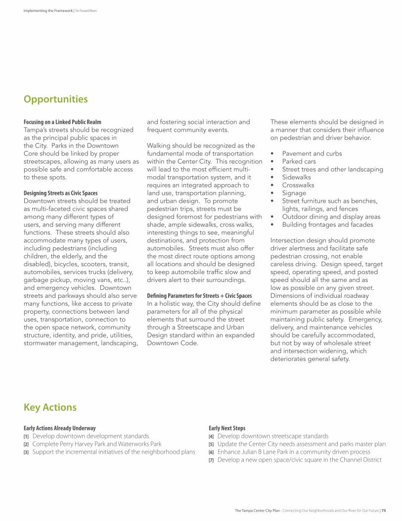
EarlyActionsAlreadyUnderway[1] Develop downtown development standards[2] Complete Perry Harvey Park and Waterworks Park[3] Support the incremental initiatives of the neighborhood plans
EarlyNextSteps[4] Develop downtown streetscape standards[5] Update the Center City needs assessment and parks master plan [6] enhance Julian b Lane Park in a community driven process[7] Develop a new open space/civic square in the Channel District
Opportunities
Key Actions
FocusingonaLinkedPublicRealmTampa’s streets should be recognized as the principal public spaces in the City. Parks in the downtown Core should be linked by proper streetscapes, allowing as many users as possible safe and comfortable access to these spots.
DesigningStreetsasCivicSpaces downtown streets should be treated as multi-faceted civic spaces shared among many different types of users, and serving many different functions. These streets should also accommodate many types of users, including pedestrians (including children, the elderly, and the disabled), bicycles, scooters, transit, automobiles, services trucks (delivery, garbage pickup, moving vans, etc..), and emergency vehicles. downtown streets and parkways should also serve many functions, like access to private property, connections between land uses, transportation, connection to the open space network, community structure, identity, and pride, utilities, stormwater management, landscaping,
and fostering social interaction and frequent community events.
Walking should be recognized as the fundamental mode of transportation within the Center City. This recognition will lead to the most efficient multi-modal transportation system, and it requires an integrated approach to land use, transportation planning, and urban design. To promote pedestrian trips, streets must be designed foremost for pedestrians with shade, ample sidewalks, cross walks, interesting things to see, meaningful destinations, and protection from automobiles. streets must also offer the most direct route options among all locations and should be designed to keep automobile traffic slow and drivers alert to their surroundings.
DefiningParametersforStreets+CivicSpacesIn a holistic way, the City should define parameters for all of the physical elements that surround the street through a streetscape and urban design standard within an expanded downtown Code.
These elements should be designed in a manner that considers their influence on pedestrian and driver behavior.
• Pavement and curbs• Parked cars• street trees and other landscaping• sidewalks• Crosswalks• signage• street furniture such as benches,
lights, railings, and fences• outdoor dining and display areas• Building frontages and facades
Intersection design should promote driver alertness and facilitate safe pedestrian crossing, not enable careless driving. design speed, target speed, operating speed, and posted speed should all the same and as low as possible on any given street. dimensions of individual roadway elements should be as close to the minimum parameter as possible while maintaining public safety. emergency, delivery, and maintenance vehicles should be carefully accommodated, but not by way of wholesale street and intersection widening, which deteriorates general safety.
The Tampa Center City Plan - Connecting Our Neighborhoods and Our River for Our Future | 75
Implementing the Framework | Ten Forward Moves

A Model for Complete Streets in Downtown
CompleteStreetElements
[A] STreeT TreeS[B]lIgHTIng[C] FurnISHIngS[D] MaTerIalS + FInISHeS[E] landSCaPe PlanTerS[F] Broad SIdeWalkS[G] on-STreeT ParkIng[H] BIke lane[I] narroW TraVel laneS[J] TexTured Turn laneS[K] STreeT PreSenCe FroM BuIldIngS
94 Street Structure Design
Components of a Streetscape
A streetscape consists of a variety of components, that when combined properly create a dynamic, engaging space. Understanding and providing space for the various components is essenti al in creati ng a successful street. These components consist of the pedestrian realm along the sidewalk, providing space for walking, talking and dining, as well as furnishings, lighti ng, landscape and street trees. On street parking, bicycle lanes, travel lanes, bus loading and unloading zones, all make-up the vehicular realm of the street. The two areas of the pedestrian realm and vehicular realm, and their associated materials and nishes should seamlessly fuse to create a thriving public space.
AAAAAAA
BBBBBBBBBBBB
CCCCCCCCCCCCDDDDDDD
EEEEEEEEEEEE
FFFF
GGGGGG
H I
JJJJJ
KKKK
Street Trees
Lighti ng
Furnishings
Materials and Finishes
A
B
C
D
Narrow Travel Lanes
Textured Turn Lanes
Street Presence from Buildings
I
J
K
Landscape Planters
Broad Sidewalks
On-Street Parking
Bicycle Lane
E
F
G
H
[A]
[E]
[I]
[B]
[F]
[J]
[C][G]
[K]
[D]
[H]
76 | The Tampa Center City Plan - Connecting Our Neighborhoods and Our River for Our Future
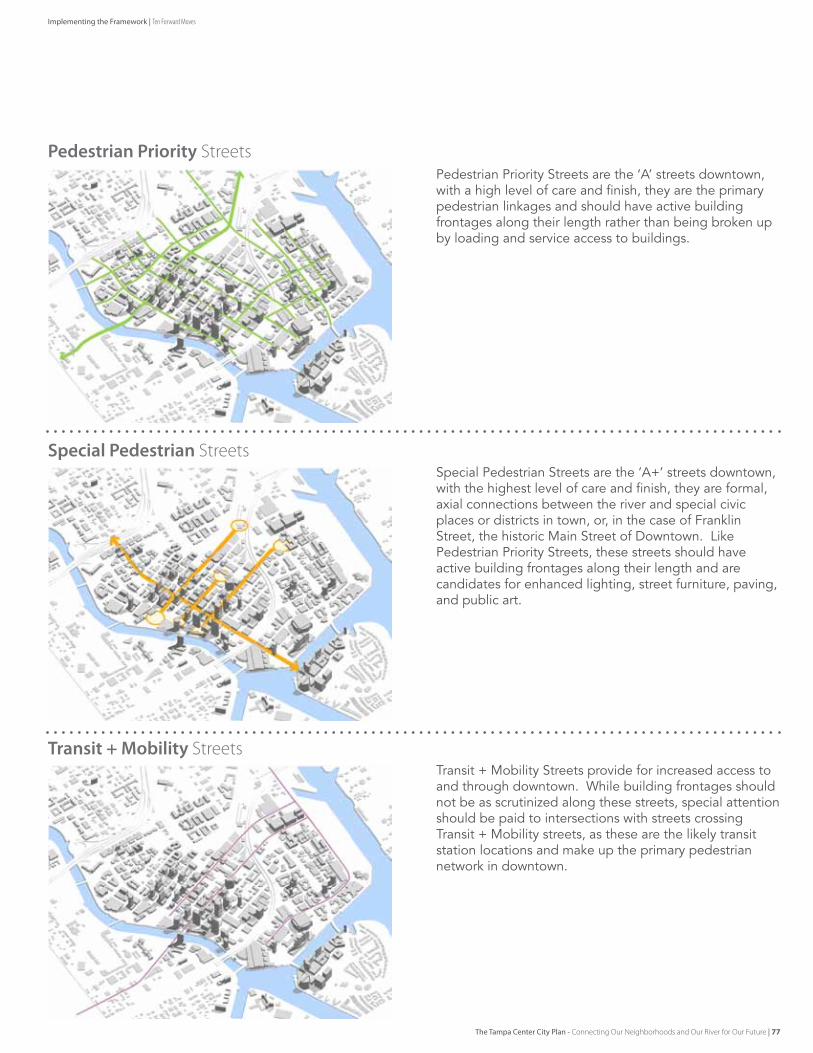
Transit + Mobility StreetsTransit + Mobility streets provide for increased access to and through downtown. While building frontages should not be as scrutinized along these streets, special attention should be paid to intersections with streets crossing Transit + Mobility streets, as these are the likely transit station locations and make up the primary pedestrian network in downtown.
Special Pedestrian Streetsspecial Pedestrian streets are the ‘A+’ streets downtown, with the highest level of care and finish, they are formal, axial connections between the river and special civic places or districts in town, or, in the case of franklin street, the historic Main street of downtown. like Pedestrian Priority streets, these streets should have active building frontages along their length and are candidates for enhanced lighting, street furniture, paving, and public art.
Pedestrian Priority StreetsPedestrian Priority streets are the ‘A’ streets downtown, with a high level of care and finish, they are the primary pedestrian linkages and should have active building frontages along their length rather than being broken up by loading and service access to buildings.
The Tampa Center City Plan - Connecting Our Neighborhoods and Our River for Our Future | 77
Implementing the Framework | Ten Forward Moves
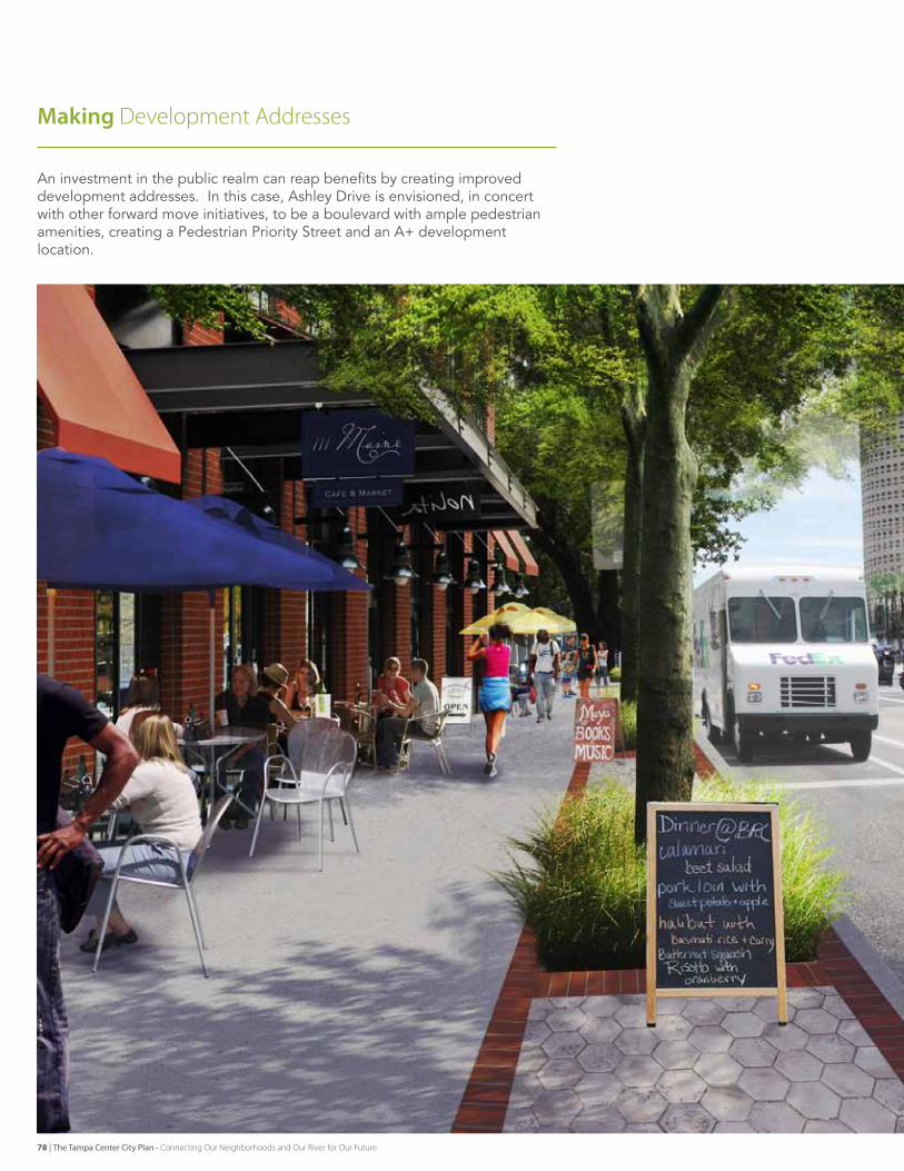
Making Development Addresses
An investment in the public realm can reap benefits by creating improved development addresses. In this case, Ashley drive is envisioned, in concert with other forward move initiatives, to be a boulevard with ample pedestrian amenities, creating a Pedestrian Priority street and an A+ development location.
78 | The Tampa Center City Plan - Connecting Our Neighborhoods and Our River for Our Future
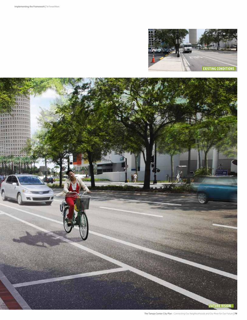
existing conditions
Future Vision
The Tampa Center City Plan - Connecting Our Neighborhoods and Our River for Our Future | 79
Implementing the Framework | Ten Forward Moves

NEIGHBORHOOD CONNeCTORS
80
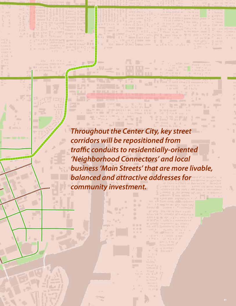
Throughout the Center City, key street corridors will be repositioned from traffic conduits to residentially-oriented ‘Neighborhood Connectors’ and local business ‘Main Streets’ that are more livable, balanced and attractive addresses for community investment.
81
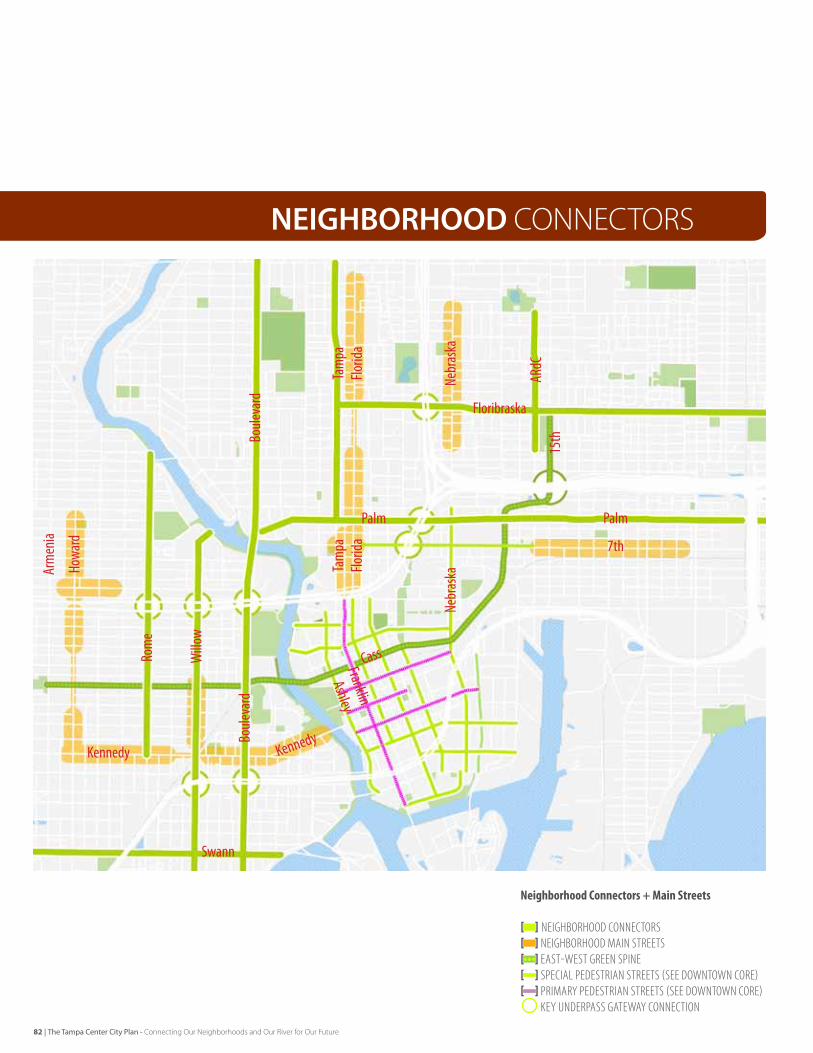
NEIGHBORHOOD CONNeCTORS
[5]
NeighborhoodConnectors+MainStreets
[] neIgHBorHood ConneCTorS[]neIgHBorHood MaIn STreeTS[] eaST-WeST green SPIne[] SPeCIal PedeSTrIan STreeTS (See doWnToWn Core)[] PrIMary PedeSTrIan STreeTS (See doWnToWn Core)
key underPaSS gaTeWay ConneCTIon
Nebr
aska
15th
ARdC
Florid
aFlo
rida
Tam
paTa
mpa
Boule
vard
Boule
vard
Arm
enia
Rom
e
Palm Palm
7th
Floribraska
Howa
rd
Willo
w
Nebr
aska
Kennedy
Swann
Cass
Kennedy
Franklin
Ashley
82 | The Tampa Center City Plan - Connecting Our Neighborhoods and Our River for Our Future
EarlyActionsAlreadyUnderway[1] Update Walk-bike to incorporate future sidewalk and bicycle
improvements
EarlyNextSteps[2] Complete a connected bike lane system for the Center City [3] Restripe oversized streets for articulated parking and/or bike
lanes and pedestrian crossings [4] Prioritize additional 4 and 5 lane streets for retrofit, road diets,
and pedestrian improvements
Opportunities
Key Actions
Tampa’s Center City is comprised of a pattern of neighborhoods, each with their own unique historic ‘main street’ commercial centers, schools and parks. The neighborhoods are linked by a very important pattern of connective streets that are significant enough to cross the Hillsborough river and in-town expressways, yet local enough that they are not identified as regional arterials. Historically, many of these streets comprised the grand estate residential boulevards and high character retail nodes of Tampa’s early urban neighborhood villages. Today, these streets carry the potential to support livable transportation including walking and biking between neighborhoods, while providing an attractive address for residential and commercial investment at a scale that is context sensitive.
BalancingCentersofCommunityLifeTampa should take special care to leverage the full value of its Neighborhood Connectors and Main streets as centers of community life.
Many of these streets have been pushed out of ‘balance’, towards a configuration that maximizes the available space for automobile capacity and speed. This widening typically results in a reduced pedestrian / bicycle environment, prolonged disinvestment, and a less attractive urban address for quality new investment. As Tampa rediscovers the value of its urban places, this trend should be reversed. In many cases, the current size of the street is not warranted based on the number of daily traffic trips, and there is a community desire for the street to more sensitively serve the needs of the adjacent local business and residential environment.
EnhancingBeautyandServiceTampa should pursue a program of enhancing the beauty and service of Neighborhood Connectors and ‘Main streets’. This should include several levels of incremental enhancement. sidewalks and Crossings at key street crossings shall be improved. Wider ‘two-lane’ roads such as Columbus drive or Cypress Avenue shall be restriped with marked on-street parking and bicycle lanes, to both clarify these facilities as well as visually narrow the streets.
Three-lane, one way streets shall be evaluated for conversion to two way, or possible restriping to introduce parking and bicycle lanes, as on swann Avenue.
RoadDietingandRebalancingtheStreetlarger four and five lane roads shall be ‘road-dieted’ to right size and rebalance the street. This supports neighborhood objectives for livable connectivity across Center City, more attractive addresses for local investment, residential life and walkable retailing. Tampa has achieved this outcome (in part) on Nebraska Avenue, in partnership with fdoT. other streets such as Palm Ave and floribraska Ave are candidates for this type of adjustment.
The vision should insure walkable, bikeable neighborhood connectivity across Center City for all residents, attractive streets for residential investment, and safe access to community assets. Tampa’s historic Main street will be walkable, character environments for local jobs, retailing and civic interaction.
The Tampa Center City Plan - Connecting Our Neighborhoods and Our River for Our Future | 83
Implementing the Framework | Ten Forward Moves
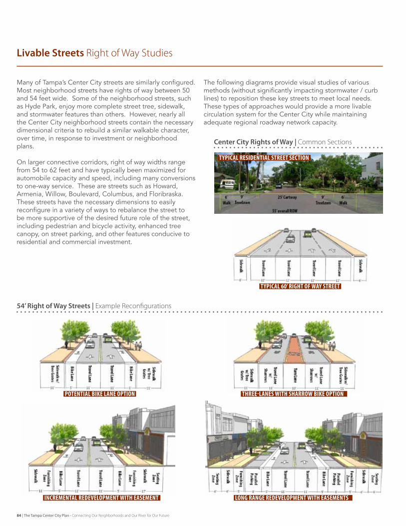
Many of Tampa’s Center City streets are similarly configured. Most neighborhood streets have rights of way between 50 and 54 feet wide. some of the neighborhood streets, such as Hyde Park, enjoy more complete street tree, sidewalk, and stormwater features than others. However, nearly all the Center City neighborhood streets contain the necessary dimensional criteria to rebuild a similar walkable character, over time, in response to investment or neighborhood plans.
on larger connective corridors, right of way widths range from 54 to 62 feet and have typically been maximized for automobile capacity and speed, including many conversions to one-way service. These are streets such as Howard, Armenia, Willow, Boulevard, Columbus, and floribraska. These streets have the necessary dimensions to easily reconfigure in a variety of ways to rebalance the street to be more supportive of the desired future role of the street, including pedestrian and bicycle activity, enhanced tree canopy, on street parking, and other features conducive to residential and commercial investment.
The following diagrams provide visual studies of various methods (without significantly impacting stormwater / curb lines) to reposition these key streets to meet local needs. These types of approaches would provide a more livable circulation system for the Center City while maintaining adequate regional roadway network capacity.
incremental redevelopment with easement long range redevelopment with easements
Livable Streets Right of Way Studies
54’ Right of Way Streets | example Reconfigurations
Center City Rights of Way | Common Sections
potential bike lane option three-lanes with sharrow bike option
typical residential street section
typical 60’ right of way street
84 | The Tampa Center City Plan - Connecting Our Neighborhoods and Our River for Our Future
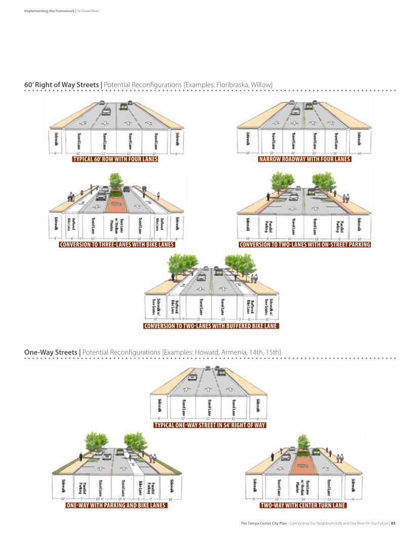
narrow roadway with four lanestypical 60’ row with four lanes
60’ Right of Way Streets | Potential Reconfigurations [examples: Floribraska, Willow]
One-Way Streets | Potential Reconfigurations [examples: Howard, Armenia, 14th, 15th]
conversion to three-lanes with bike lanes
one-way with parking and bike lanes
typical one-way street in 54’ right of way
conversion to two-lanes with on-street parking
conversion to two-lanes with buffered bike lane
two-way with center turn lane
The Tampa Center City Plan - Connecting Our Neighborhoods and Our River for Our Future | 85
Implementing the Framework | Ten Forward Moves
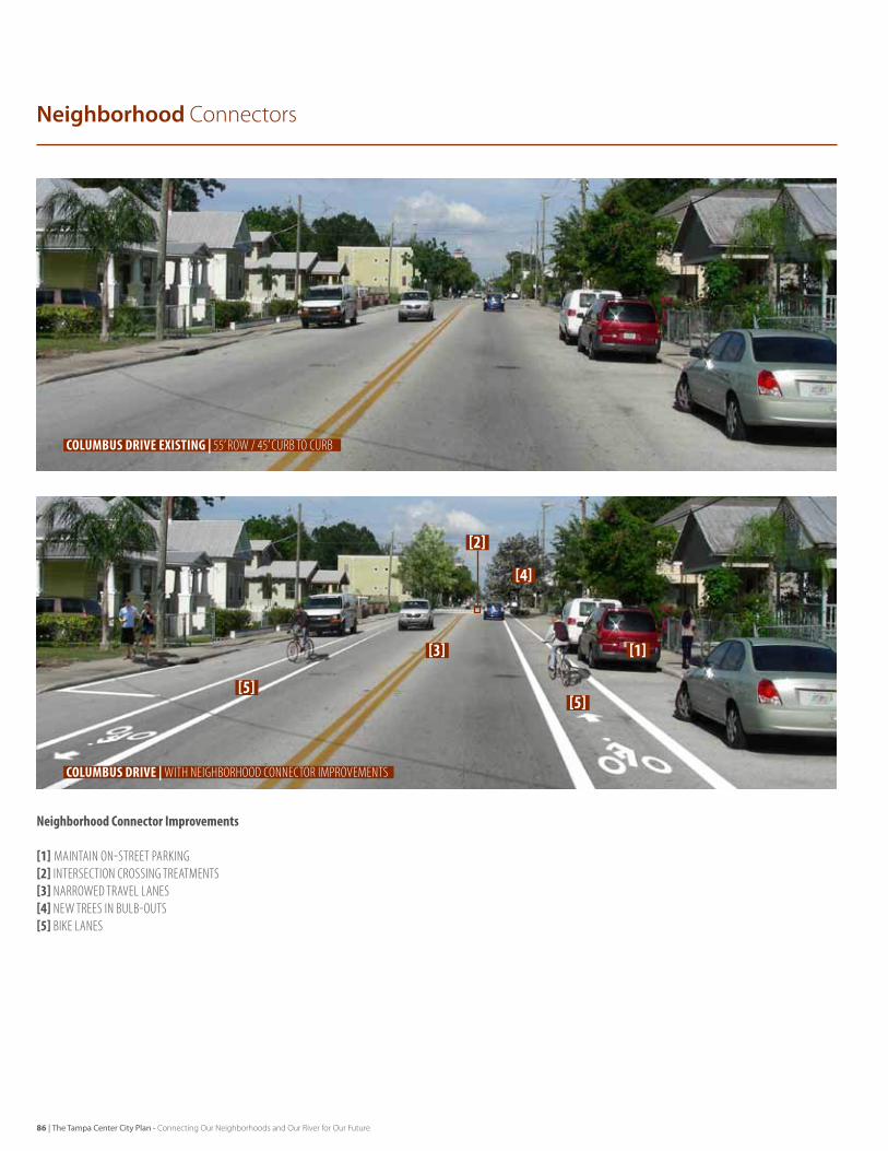
Neighborhood Connectors
columbus drive existing | 55’ row / 45’ curb to curb
columbus drive | With Neighborhood CoNNeCtor improvemeNts
NeighborhoodConnectorImprovements
[1] MaInTaIn on-STreeT ParkIng[2]InTerSeCTIon CroSSIng TreaTMenTS[3] narroWed TraVel laneS[4] neW TreeS In BulB-ouTS[5] BIke laneS
[1]
[2]
[3]
[4]
[5][5]
86 | The Tampa Center City Plan - Connecting Our Neighborhoods and Our River for Our Future
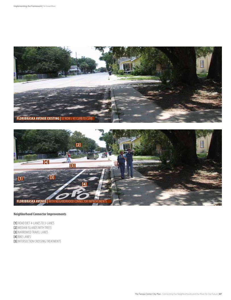
Floribraska avenue existing | 55’ row / 45’ curb to curb
Floribraska avenue | With Neighborhood CoNNeCtor improvemeNts
NeighborhoodConnectorImprovements
[1] road dIeT 4-laneS To 3-laneS[2]MedIan ISlandS WITH TreeS[3] narroWed TraVel laneS[4] BIke laneS[5] InTerSeCTIon CroSSIng TreaTMenTS
[1]
[2]
[3][4]
[4][5]
The Tampa Center City Plan - Connecting Our Neighborhoods and Our River for Our Future | 87
Implementing the Framework | Ten Forward Moves
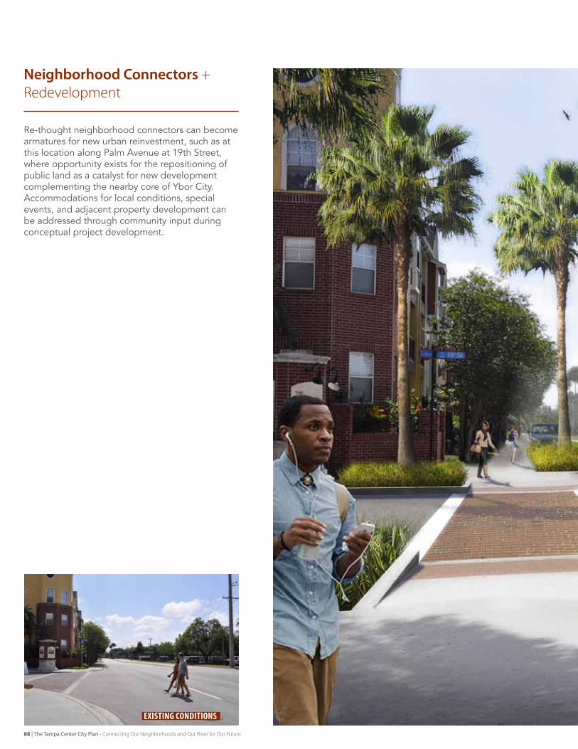
re-thought neighborhood connectors can become armatures for new urban reinvestment, such as at this location along Palm Avenue at 19th street, where opportunity exists for the repositioning of public land as a catalyst for new development complementing the nearby core of Ybor City. Accommodations for local conditions, special events, and adjacent property development can be addressed through community input during conceptual project development.
Neighborhood Connectors + Redevelopment
existing conditions
88 | The Tampa Center City Plan - Connecting Our Neighborhoods and Our River for Our Future
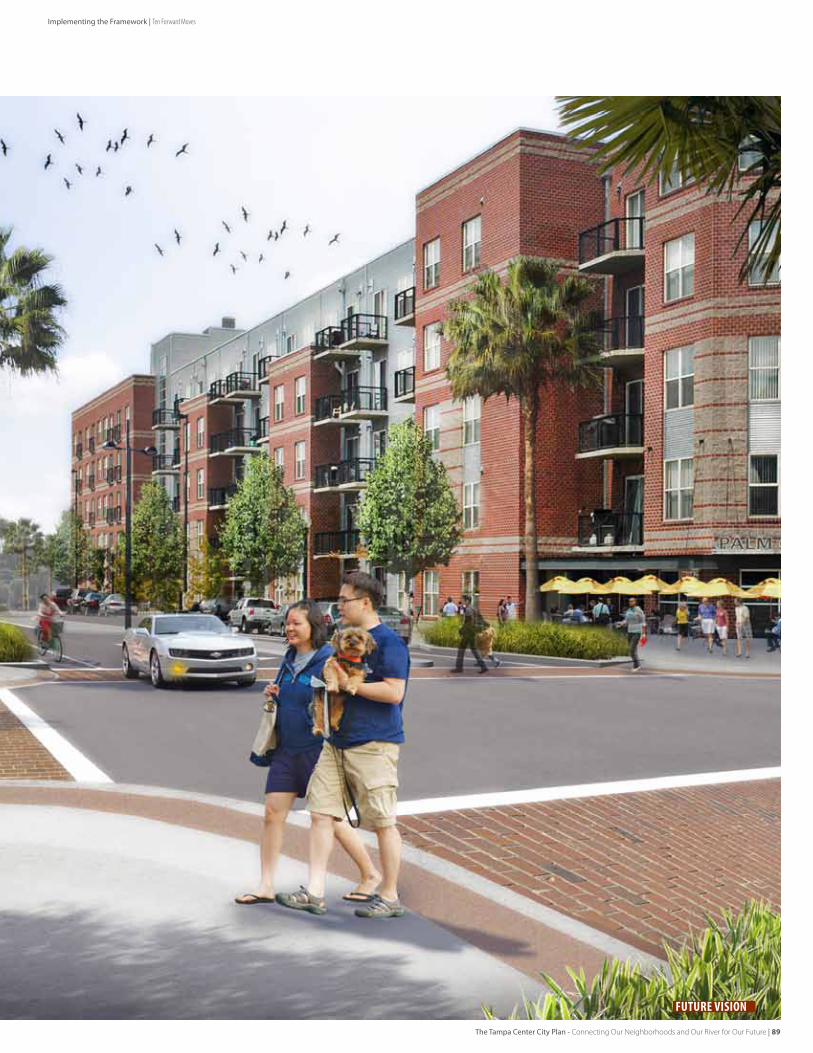
Future Vision
The Tampa Center City Plan - Connecting Our Neighborhoods and Our River for Our Future | 89
Implementing the Framework | Ten Forward Moves
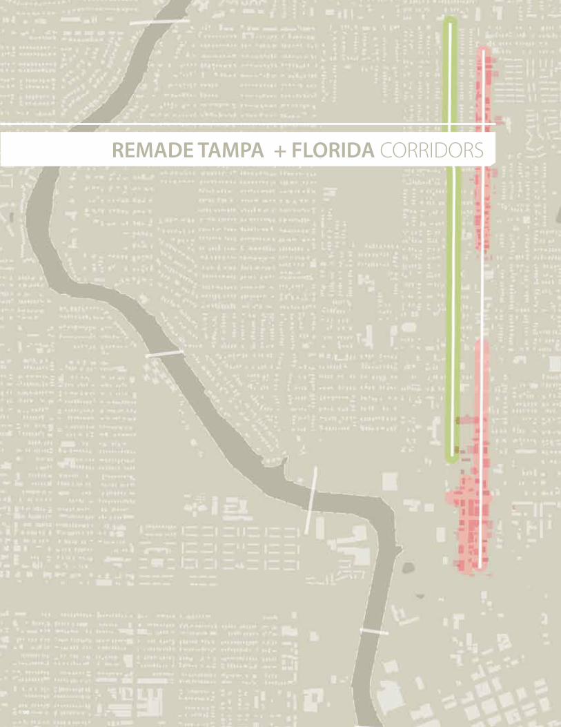
REMADE TAMPA + FLORIDA CORRIDORS
90
Rebalance Tampa Street and Florida Avenue as local streets, joining neighborhoods while providing regional access.
91
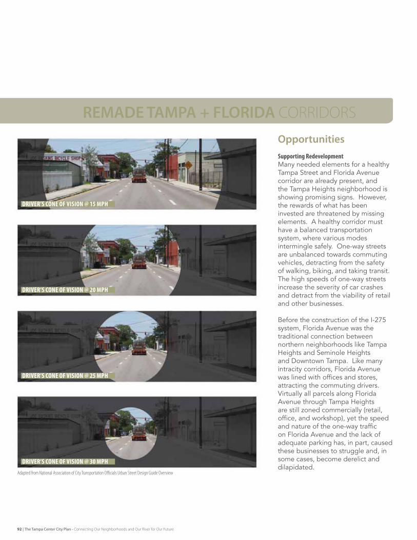
REMADE TAMPA + FLORIDA CORRIDORS
OpportunitiesSupportingRedevelopmentMany needed elements for a healthy Tampa street and florida Avenue corridor are already present, and the Tampa Heights neighborhood is showing promising signs. However, the rewards of what has been invested are threatened by missing elements. A healthy corridor must have a balanced transportation system, where various modes intermingle safely. one-way streets are unbalanced towards commuting vehicles, detracting from the safety of walking, biking, and taking transit. The high speeds of one-way streets increase the severity of car crashes and detract from the viability of retail and other businesses.
Before the construction of the I-275 system, florida Avenue was the traditional connection between northern neighborhoods like Tampa Heights and seminole Heights and downtown Tampa. like many intracity corridors, florida Avenue was lined with offices and stores, attracting the commuting drivers. virtually all parcels along florida Avenue through Tampa Heights are still zoned commercially (retail, office, and workshop), yet the speed and nature of the one-way traffic on florida Avenue and the lack of adequate parking has, in part, caused these businesses to struggle and, in some cases, become derelict and dilapidated.
driver’s cone of vision @ 15 mph
driver’s cone of vision @ 20 mph
driver’s cone of vision @ 25 mph
driver’s cone of vision @ 30 mph
adapted from national association of City Transportation officials urban Street design guide overview
92 | The Tampa Center City Plan - Connecting Our Neighborhoods and Our River for Our Future
EarlyActionsAlreadyUnderway[1] meeting with FDOT District Secretary to review prior studies,
current situation, and City vision
EarlyNextSteps[2] Initiate an updated study of two way function for the Tampa +
Florida Corridors, based on reasonable growth factor: [] Current traffic [] Potential time and capacity change with two-way [] Projection of peak hour trips to I-275[3] Develop corridor-wide design and development standards for
new development
Key Actions
Conversion to two-way travel supports neighborhood business owners through an increase in visibility and the provision of improved access and potential on-street parking. The health of neighborhood businesses is critically important since they represent a large presence in the corridor and their redevelopment will be necessary to transform it.
on-street parking encourages business activity not only through the provision of needed parking spaces, but also through the creation of a more pleasant and safer pedestrian environment. The parked vehicles act as a buffer between the sidewalk and the moving vehicles. The more pleasant the sidewalk experience, the more likely that shoppers will visit and window-shop along a revitalized florida Avenue business corridor.
Cut-ThroughCirculationone-way streets require that even neighborhood residents create cut-through traffic. To reach businesses along florida Avenue or homes along Tampa street, half of all patrons or residents must circulate around the block to reach their destination.
CongestionAvoidanceCut-ThroughTo get around congestion or an accident, drivers may try to find a parallel route. Within a grid pattern of streets such as Tampa Heights, congestion avoidance cut-through is easier. While neighborhood streets might provide a tempting way around some congestion, the time costs of turning off then back on slow and narrow side streets are relatively large for the commuter. However, the shifting of some traffic onto parallel routes is a sign of a robust street network performing as designed.
NeighborhoodReconnectionWhen high-speed one-way streets bisect neighborhoods, such as Tampa street and florida Avenue bisecting the Tampa Heights neighborhoods, neighborhoods divide and cohesion suffers. Parents warn children to stay away from the street, and neighbors are cut-off from their own neighborhood amenities. visiting Plymouth Playground or robles Park becomes dangerous. High-speed commuter routes through neighborhoods contribute toward social and economic decline and hinder efforts at redevelopment. The reduction in pedestrian danger from lower speeds will encourage the reintegration of the neighborhoods,as well as encourage pedestrian shopping along florida Avenue.
EvaluatingAlternativeFuturesfortheCorridorsThe City should partner with fdoT to study role and speed of traffic on the corridors and their relationship to I-275. This should include an analysis of the speed and travel time on the corridors today, the potential change in time and capacity if the streets were converted to two-way service, a projection of peak hour trips that might shift to I-275, reasonable estimates of long term growth within these established corridors, the utilization of other network and multi-modal approaches to some trips. The study must also consider the land use, neighborhood cohesiveness, and business environment impacts and benefits of these alternative futures.
The Tampa Center City Plan - Connecting Our Neighborhoods and Our River for Our Future | 93
Implementing the Framework | Ten Forward Moves
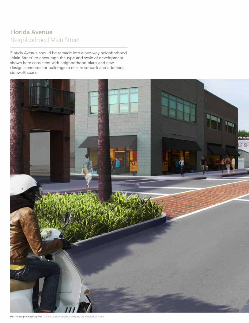
Florida Avenue Neighborhood main Street
florida Avenue should be remade into a two-way neighborhood ‘Main street’ to encourage the type and scale of development shown here consistent with neighborhood plans and new design standards for buildings to ensure setback and additional sidewalk space.
94 | The Tampa Center City Plan - Connecting Our Neighborhoods and Our River for Our Future
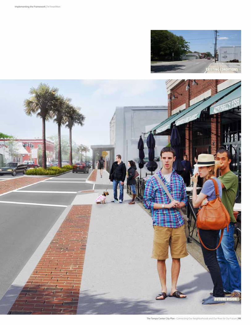
existing conditions
Future Vision
Implementing the Framework | Ten Forward Moves
The Tampa Center City Plan - Connecting Our Neighborhoods and Our River for Our Future | 95
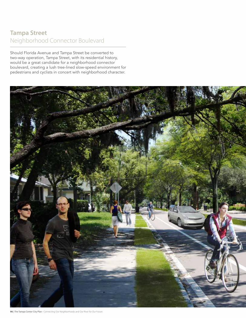
Tampa StreetNeighborhood Connector boulevard
should florida Avenue and Tampa street be converted to two-way operation, Tampa street, with its residential history, would be a great candidate for a neighborhood connector boulevard, creating a lush tree-lined slow-speed environment for pedestrians and cyclists in concert with neighborhood character.
96 | The Tampa Center City Plan - Connecting Our Neighborhoods and Our River for Our Future
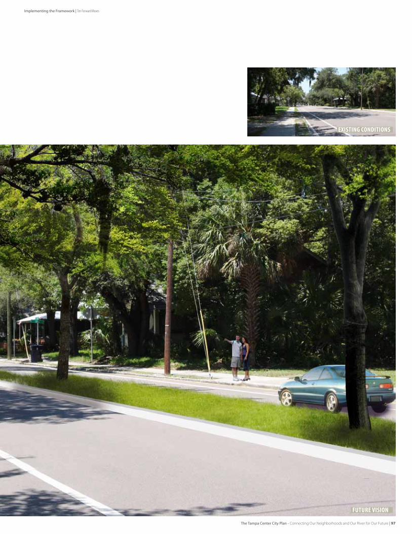
existing conditions
Future Vision
Implementing the Framework | Ten Forward Moves
The Tampa Center City Plan - Connecting Our Neighborhoods and Our River for Our Future | 97
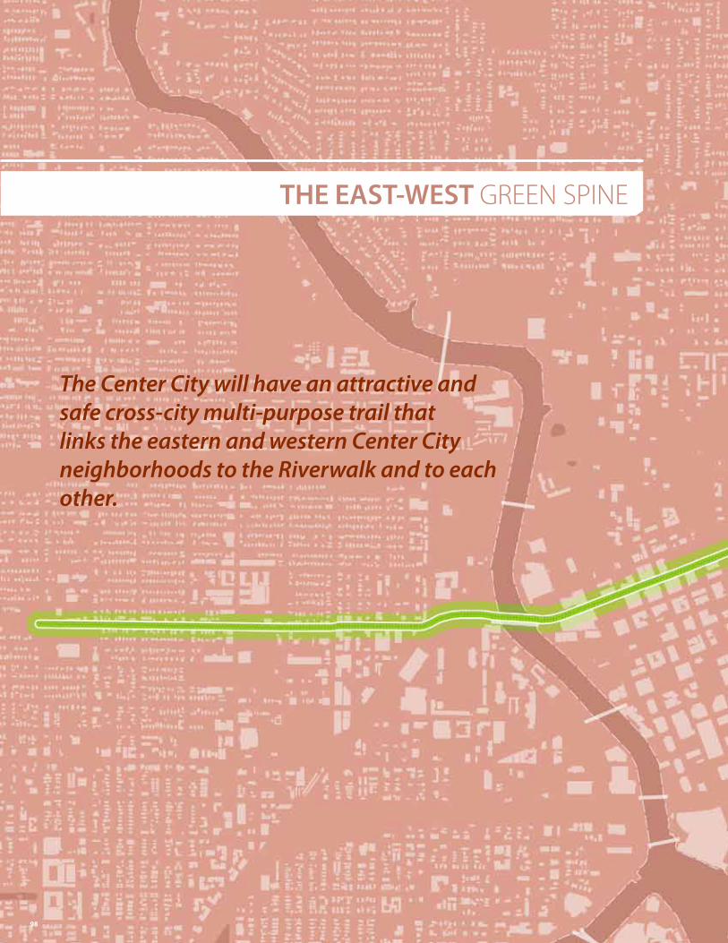
THE EAST-WEST GReeN SPINe
The Center City will have an attractive and safe cross-city multi-purpose trail that links the eastern and western Center City neighborhoods to the Riverwalk and to each other.
98
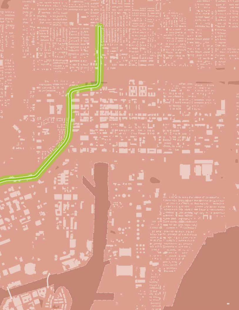
99
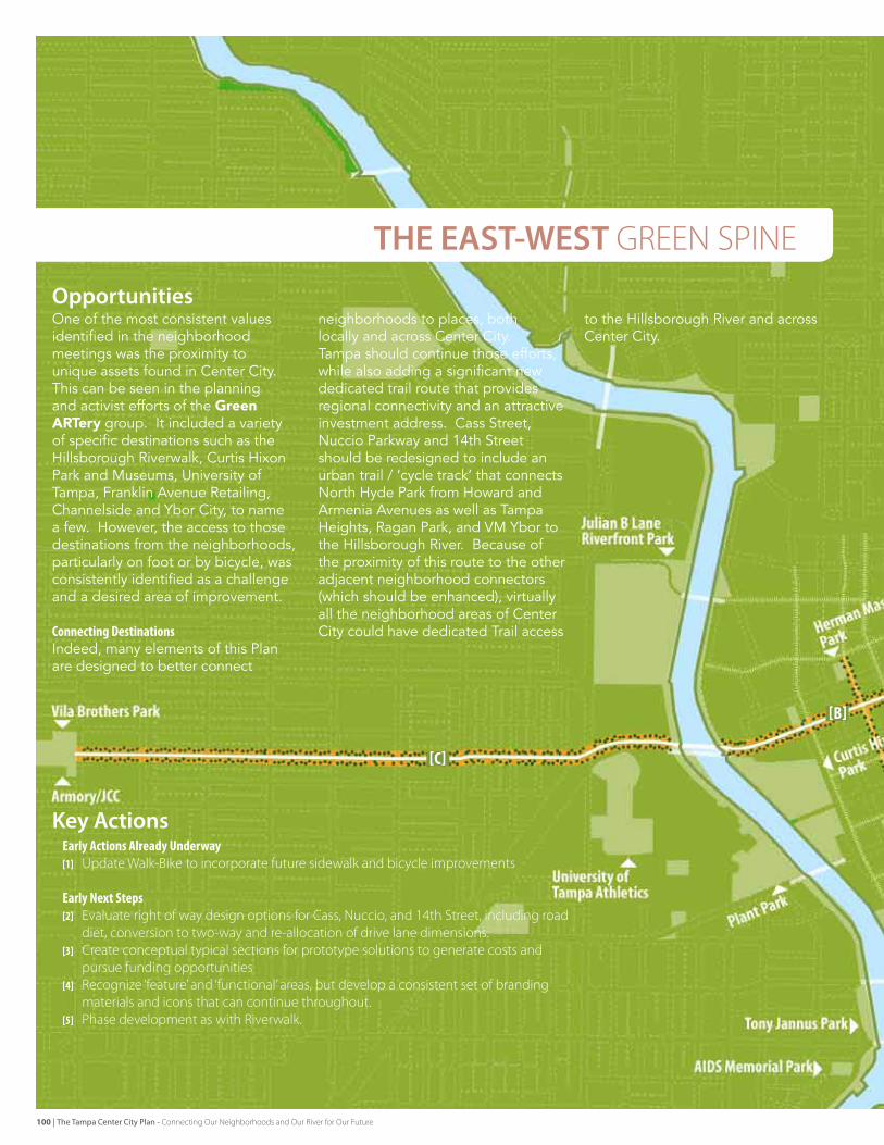
EarlyActionsAlreadyUnderway[1] Update Walk-bike to incorporate future sidewalk and bicycle improvements
EarlyNextSteps[2] evaluate right of way design options for Cass, Nuccio, and 14th Street, including road
diet, conversion to two-way and re-allocation of drive lane dimensions. [3] Create conceptual typical sections for prototype solutions to generate costs and
pursue funding opportunities[4] Recognize ‘feature’ and ‘functional’ areas, but develop a consistent set of branding
materials and icons that can continue throughout. [5] Phase development as with Riverwalk.
one of the most consistent values identified in the neighborhood meetings was the proximity to unique assets found in Center City. This can be seen in the planning and activist efforts of the Green ARTery group. It included a variety of specific destinations such as the Hillsborough riverwalk, Curtis Hixon Park and Museums, university of Tampa, franklin Avenue retailing, Channelside and Ybor City, to name a few. However, the access to those destinations from the neighborhoods, particularly on foot or by bicycle, was consistently identified as a challenge and a desired area of improvement.
ConnectingDestinationsIndeed, many elements of this Plan are designed to better connect
neighborhoods to places, both locally and across Center City. Tampa should continue those efforts, while also adding a significant new dedicated trail route that provides regional connectivity and an attractive investment address. Cass street, Nuccio Parkway and 14th street should be redesigned to include an urban trail / ‘cycle track’ that connects North Hyde Park from Howard and Armenia Avenues as well as Tampa Heights, ragan Park, and vM Ybor to the Hillsborough river. Because of the proximity of this route to the other adjacent neighborhood connectors (which should be enhanced), virtually all the neighborhood areas of Center City could have dedicated Trail access
to the Hillsborough river and across Center City.
THE EAST-WEST GReeN SPINe
[B]
[C]
Opportunities
Key Actions
100 | The Tampa Center City Plan - Connecting Our Neighborhoods and Our River for Our Future
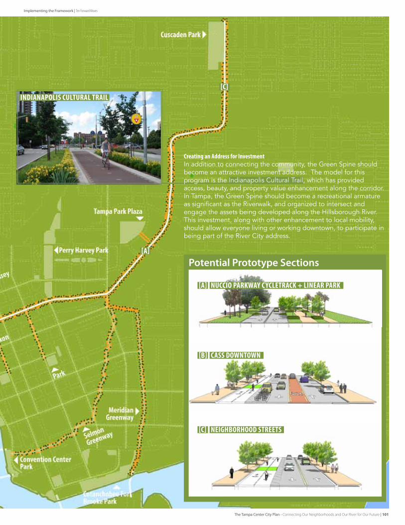
Potential Prototype Sections
CreatinganAddressforInvestmentIn addition to connecting the community, the green spine should become an attractive investment address. The model for this program is the Indianapolis Cultural Trail, which has provided access, beauty, and property value enhancement along the corridor. In Tampa, the green spine should become a recreational armature as significant as the riverwalk, and organized to intersect and engage the assets being developed along the Hillsborough river. This investment, along with other enhancement to local mobility, should allow everyone living or working downtown, to participate in being part of the river City address.
[A] nuccio parkway cycletrack + linear park
cass downtown
neighborhood streets
[A]
[C]
[b]
[c]
indianapolis cultural trail
Implementing the Framework | Ten Forward Moves
The Tampa Center City Plan - Connecting Our Neighborhoods and Our River for Our Future | 101
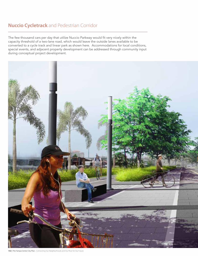
Nuccio Cycletrack and Pedestrian Corridor
The few thousand cars per day that utilize Nuccio Parkway would fit very nicely within the capacity threshold of a two-lane road, which would leave the outside lanes available to be converted to a cycle track and linear park as shown here. Accommodations for local conditions, special events, and adjacent property development can be addressed through community input during conceptual project development.
102 | The Tampa Center City Plan - Connecting Our Neighborhoods and Our River for Our Future
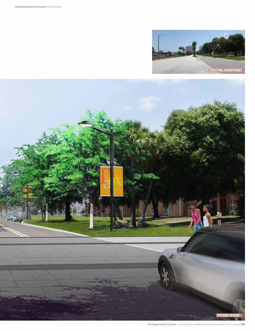
existing conditions
Future Vision
Implementing the Framework | Ten Forward Moves
The Tampa Center City Plan - Connecting Our Neighborhoods and Our River for Our Future | 103
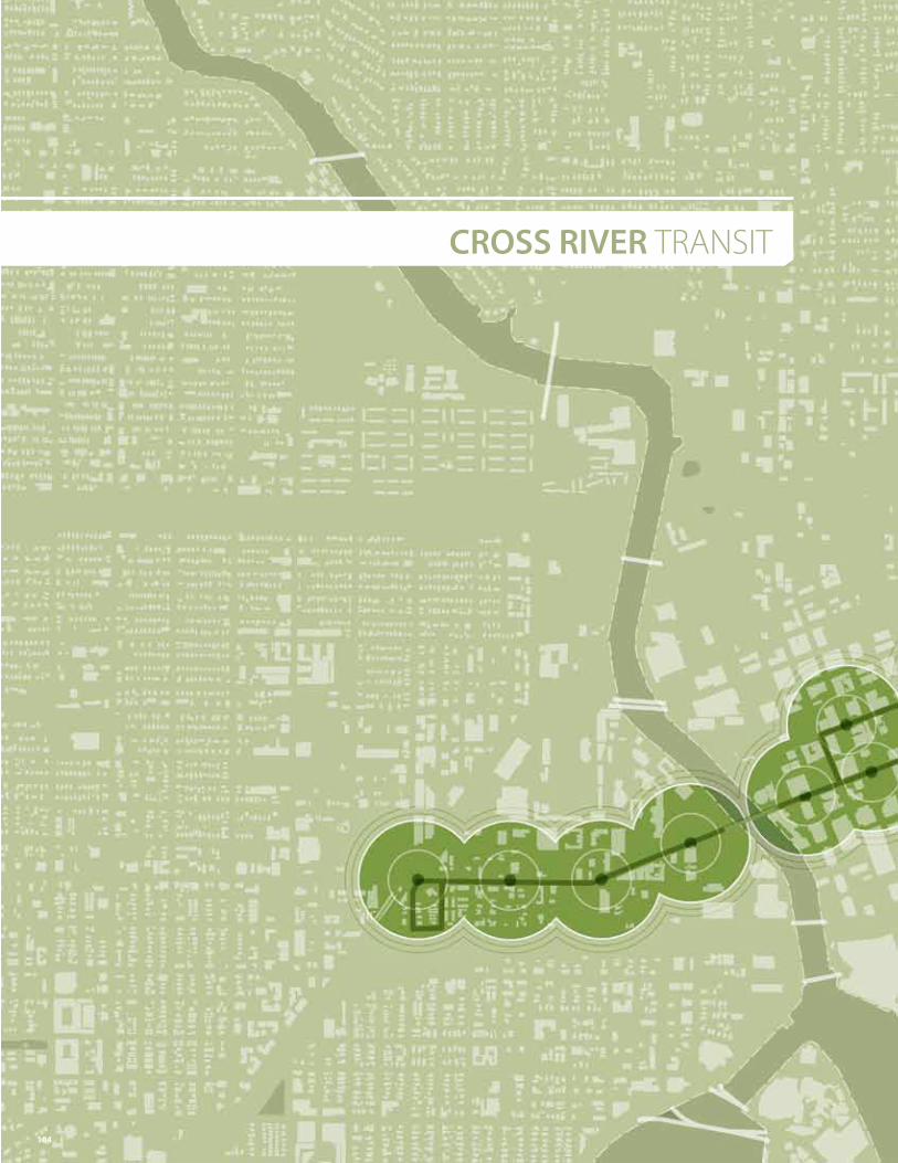
CROSS RIVER TRANSIT
104
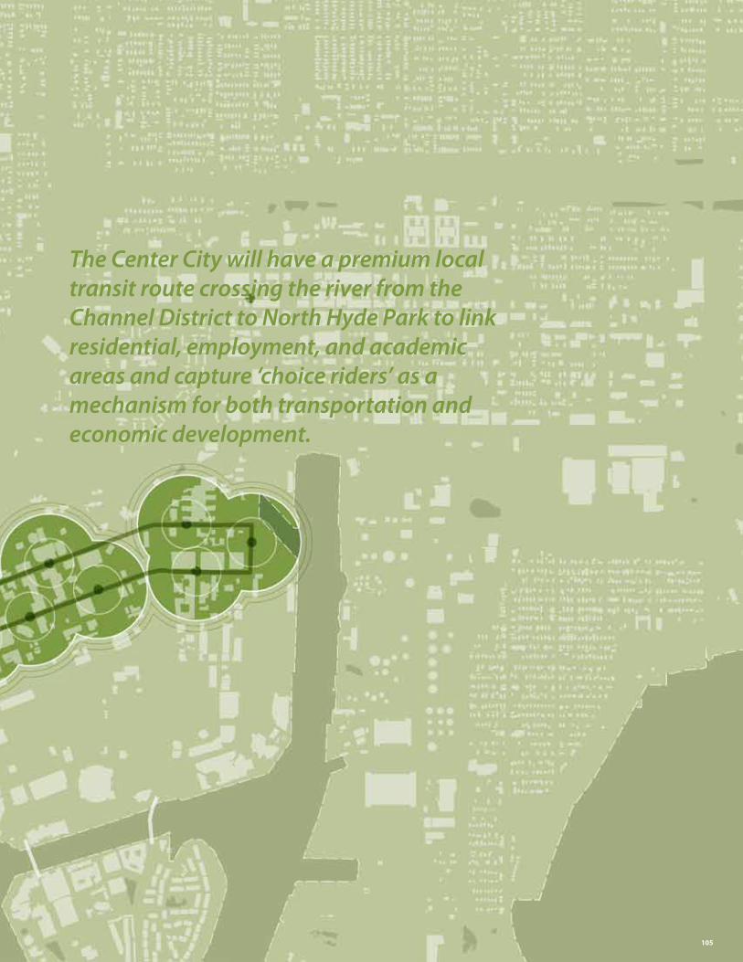
The Center City will have a premium local transit route crossing the river from the Channel District to North Hyde Park to link residential, employment, and academic areas and capture ‘choice riders’ as a mechanism for both transportation and economic development.
105
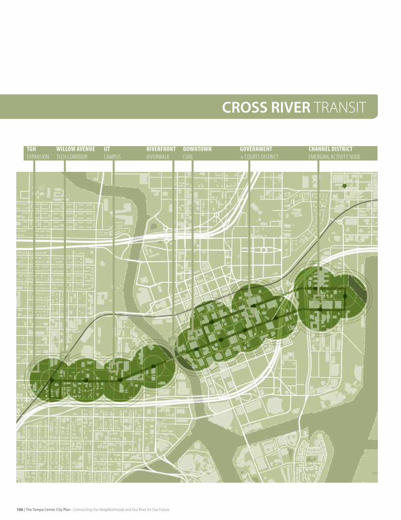
CROSS RIVER TRANSIT
WILLOWAVENUETeCH CorrIdor
TGHexPanSIon
UTCaMPuS
RIVERFRONTrIVerWalk
DOWNTOWNCore
GOVERNMENT+ CourTS dISTrICT
CHANNELDISTRICTeMergIng aCTIVITy node
106 | The Tampa Center City Plan - Connecting Our Neighborhoods and Our River for Our Future
EarlyNextSteps[1] Partner with FDOT to evaluate two way conversion of Kennedy
boulevard[2] Partner with HART and other transit agencies to evaluate
alternative alignments [3] Identify key reinvestment sites on the alignment[4] Develop funding strategy
Opportunities
Key Actions
Tampa and the larger community are evaluating many alternatives to address transit and alternative access within and around Center City, as well as the region. This includes current rubber tire trolley, streetcar, bus / rapid transit technologies, along with future vision towards regional light rail, commuter rail and statewide high speed rail. each of these technologies relates to linking specific scales of place and providing an alternative to specific types of trips. In any case, at any scale, one of the key attributes of viable urban development is accessible transit, and one of the key attributes of viable transit is places of dense activity that link origins (such as residential) to destinations (such as jobs).
GrowthonBothSidesofRiverinDowntownWithin Center City, Tampa is enjoying significant new investment on each side of the Hillsborough river, with the promise of future momentum. Channelside is an area of dense residential and emerging services and retail, downtown is growing with new hotel, office, residential, retail and hi-tech investments.
The university of Tampa and Tampa general Hospital are expanding and North Hyde Park is experiencing new residential and commercial investment. The kennedy Boulevard corridor draws on this energy as an area of current and future investment, density and exchange between areas.
LinkingDestinationswithTransitTampa should work in collaboration with fdoT and HArT to develop a highly branded Bus Transit system that is responsive to the current and future opportunity for this east-West area to develop and evolve. future residents, students, educators, skilled workforce and visitors will be joined along this valuable spine, which will, over time, be expanded to extend north to West Tampa, The Heights and Ybor City. The initial highly branded bus alignment can also be an evolutionary route to eventual streetcar as with the Portland streetcar.
RebalancingKennedyBoulevardTampa should rebalance kennedy Boulevard as multi-modal corridor, centered on the Hillsborough river, and linking key downtown activity areas.
The potential route for east-West linkage is centered on kennedy Boulevard and may include Twiggs street or other alignments based on the eventual reconfiguration of downtown one-way streets. Today, kennedy Boulevard acts as a four-lane, one-way ‘off ramp’ from the selmon expressway for nearly nine blocks until reaching Ashley drive and converting to two way function. This condition can be evaluated for conversion to two-way at a point closer to the selmon expressway, better dispersing traffic into the City, making kennedy Boulevard more livable and lessening the turning movement congestion at Ashley drive and Jackson street.
Together, the east-West transit route, and repositioning of kennedy Boulevard will enhance this corridor for investment and livable, multi-modal circulation within Center City.
Implementing the Framework | Ten Forward Moves
The Tampa Center City Plan - Connecting Our Neighborhoods and Our River for Our Future | 107
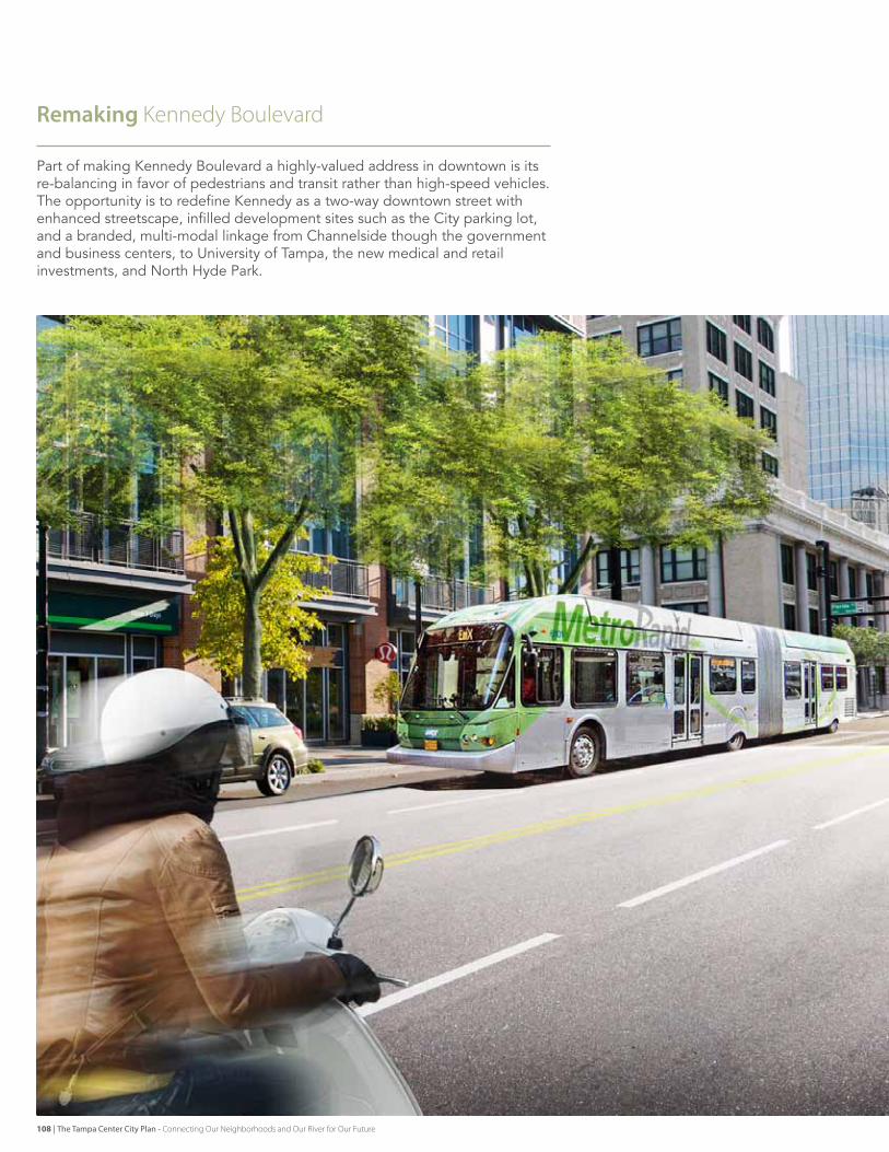
Remaking Kennedy boulevard
Part of making kennedy Boulevard a highly-valued address in downtown is its re-balancing in favor of pedestrians and transit rather than high-speed vehicles. The opportunity is to redefine kennedy as a two-way downtown street with enhanced streetscape, infilled development sites such as the City parking lot, and a branded, multi-modal linkage from Channelside though the government and business centers, to university of Tampa, the new medical and retail investments, and North Hyde Park.
108 | The Tampa Center City Plan - Connecting Our Neighborhoods and Our River for Our Future
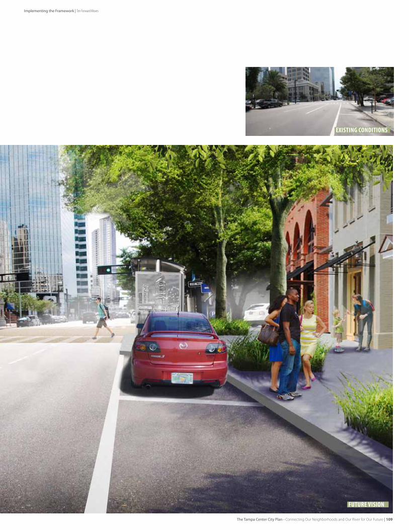
existing conditions
Future Vision
Implementing the Framework | Ten Forward Moves
The Tampa Center City Plan - Connecting Our Neighborhoods and Our River for Our Future | 109
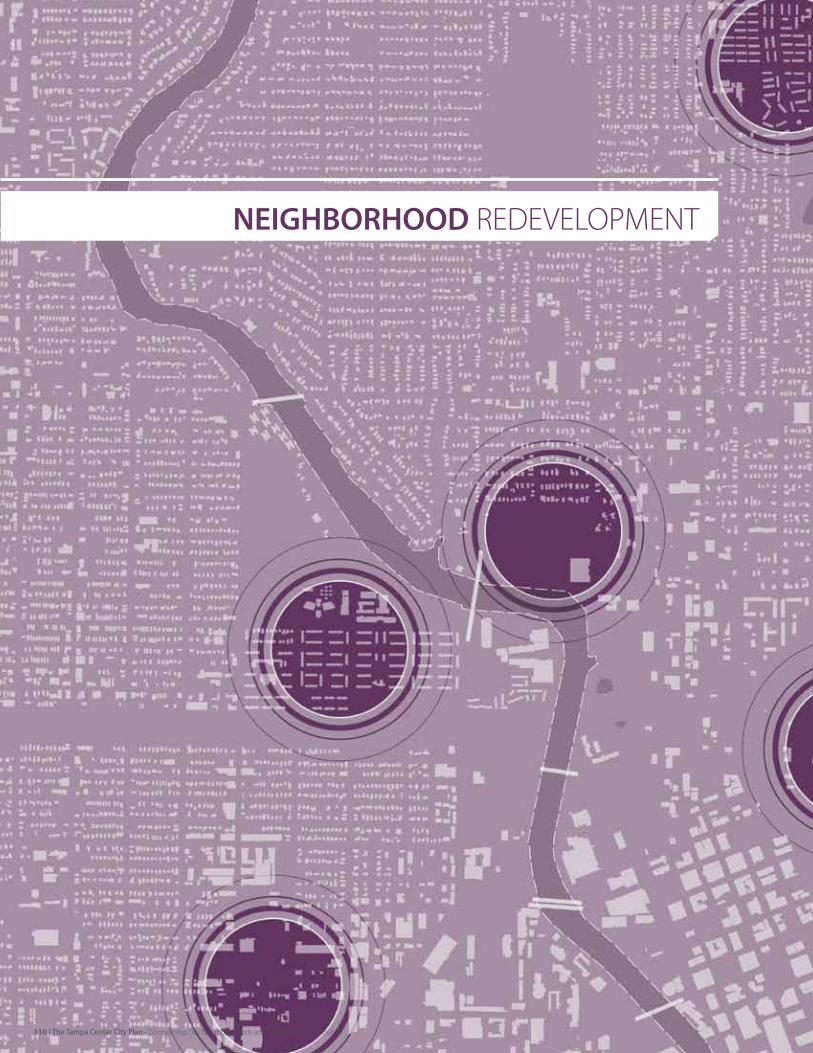
NEIGHBORHOOD ReDeveLOPmeNT
110 | The Tampa Center City Plan - Connecting Our Neighborhoods and Our River for Our Future
Tampa will have strong and healthy neighborhoods in the Center City.
The Tampa Center City Plan - Connecting Our Neighborhoods and Our River for Our Future | 111
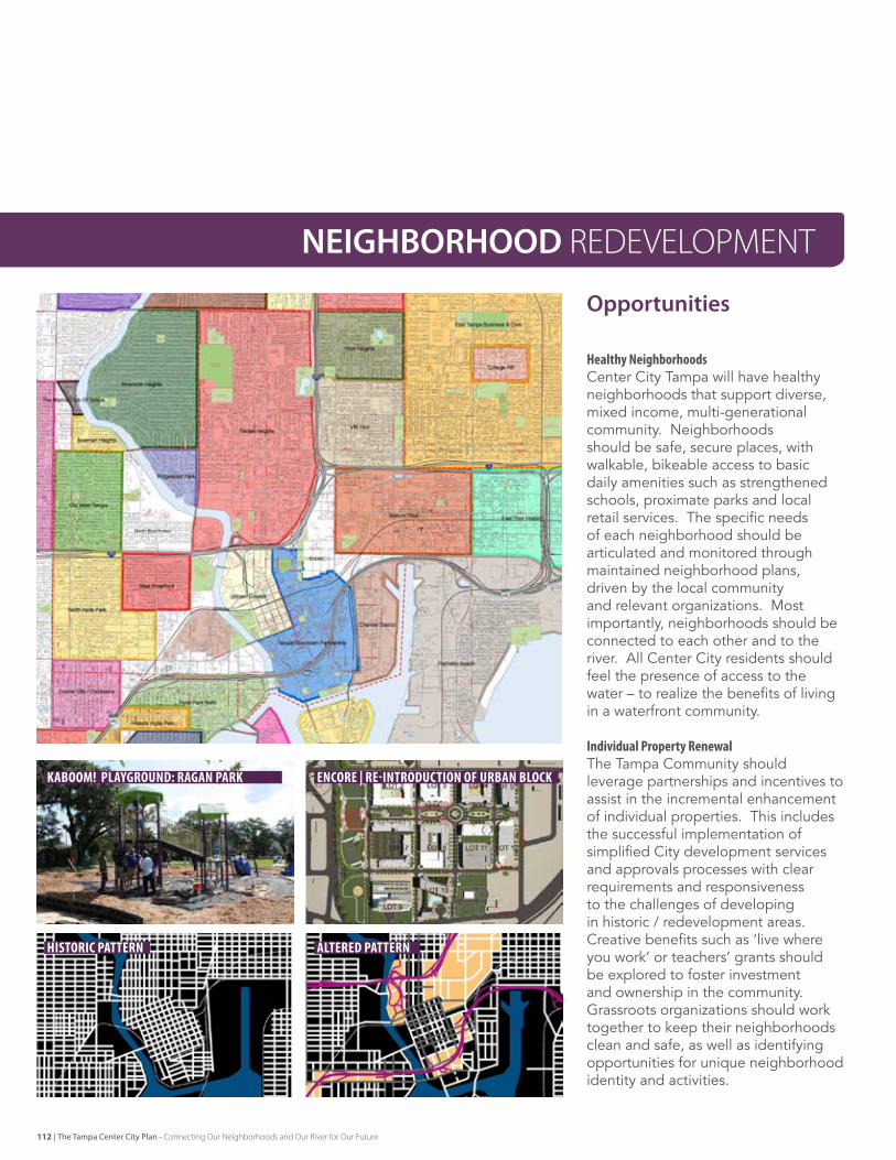
North Blvd Homes
Encore
historic pattern
kaboom! playground: ragan park
altered pattern
encore | re-introduction of urban block
Opportunities
NEIGHBORHOOD ReDeveLOPmeNT
HealthyNeighborhoodsCenter City Tampa will have healthy neighborhoods that support diverse, mixed income, multi-generational community. Neighborhoods should be safe, secure places, with walkable, bikeable access to basic daily amenities such as strengthened schools, proximate parks and local retail services. The specific needs of each neighborhood should be articulated and monitored through maintained neighborhood plans, driven by the local community and relevant organizations. Most importantly, neighborhoods should be connected to each other and to the river. All Center City residents should feel the presence of access to the water – to realize the benefits of living in a waterfront community.
IndividualPropertyRenewalThe Tampa Community should leverage partnerships and incentives to assist in the incremental enhancement of individual properties. This includes the successful implementation of simplified City development services and approvals processes with clear requirements and responsiveness to the challenges of developing in historic / redevelopment areas. Creative benefits such as ‘live where you work’ or teachers’ grants should be explored to foster investment and ownership in the community. grassroots organizations should work together to keep their neighborhoods clean and safe, as well as identifying opportunities for unique neighborhood identity and activities.
112 | The Tampa Center City Plan - Connecting Our Neighborhoods and Our River for Our Future
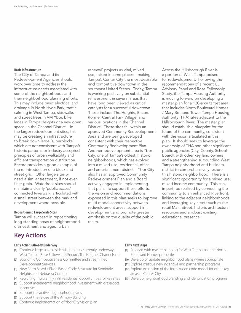
Implementing the Framework | Ten Forward Moves
EarlyActionsAlreadyUnderway[1] Continue large scale residential projects currently underway:
West Tampa [Rose Fellowship],encore, The Heights, Channelside[2] economic Competitiveness Committee and streamlined
Development Services[3] New Form based / Place based Code Structure for Seminole
Heights and Nebraska Corridor[4] Recruiting multifamily infill residential opportunities for key sites[5] Support incremental neighborhood investment with grassroots
incentives[6] Support the active neighborhood plans[7] Support the re-use of the Armory building[8] Continue implementation of Ybor City vision plan
EarlyNextSteps[9] Proceed with master planning for West Tampa and the North
boulevard Homes properties[10] Develop or update neighborhood plans where appropriate[11] explore creative new incentive and partnership programs[12] explore expansion of the form-based code model for other key
areas of Center City[13] Develop neighborhood branding and identification programs
Key Actions
BasicInfrastructureThe City of Tampa and its redevelopment Agencies should work over time to address the infrastructure needs associated with some of the neighborhoods and their neighborhood planning efforts. This may include basic electrical and drainage in North Hyde Park, traffic calming in West Tampa, sidewalks and street trees in vM Ybor, bike lanes in Tampa Heights or a new open space in the Channel district. In the larger redevelopment sites, this may be creating an infrastructure to break down large ‘superblocks’ which are not consistent with Tampa’s historic patterns or industry accepted principles of urban walkability and efficient transportation distribution. encore provides a good example of the re-introduction of a block and street grid. other large sites will need a similar treatment, if not even finer grain. Waterfront sites should maintain a clearly ‘public access’ connected riverwalk, articulated with a small street between the park and development where possible.
RepositioningLargeScaleSitesTampa will succeed in repositioning long-standing areas of neighborhood disinvestment and aged ‘urban
renewal’ projects as vital, mixed use, mixed income places – making Tampa’s Center City the most desirable and competitive downtown in the southeast united states. Today, Tampa is working positively on substantial reinvestment in several areas that have long been viewed as critical catalysts for a successful downtown. These include The Heights, encore (former Central Park village) and various locations in the Channel district. These sites fall within an approved Community redevelopment Area and are being developed consistent with their respective Community redevelopment Plan. Another redevelopment area is Ybor City, one of Tampa’s oldest, historic neighborhoods, which has evolved into a mixed-use, residential, office and entertainment district. Ybor City also has an approved Community redevelopment Plan and a Board actively engaged in implementing that plan. To support these efforts, the vision and recommendations expressed in this plan seeks to improve multi-modal connectivity between redevelopment areas, support infill development and promote greater emphasis on the quality of the public realm.
Across the Hillsborough river is a portion of West Tampa poised for redevelopment. following the recommendations of a recent ulI Advisory Panel and rose fellowship study, the Tampa Housing Authority is moving forward on developing a master plan for a 120-arce target area that includes North Boulevard Homes / Mary Bethune Tower Tampa Housing Authority (THA) sites adjacent to the Hillsborough river. The master plan should establish a blueprint for the future of the community, consistent with the vision articulated in this plan. It should seek to leverage the ownership of THA and other significant public agencies (City, County, school Board), with other key land owners and a strengthening surrounding West Tampa neighborhood and business district to comprehensively restore this historic neighborhood. There is a significant opportunity for a mixed use, mixed income community. This can, in part, be realized by connecting the community to an enhanced riverfront, linking to the adjacent neighborhoods and leveraging key assets such as the retail Main street, historic architectural resources and a robust existing educational presence.
The Tampa Center City Plan - Connecting Our Neighborhoods and Our River for Our Future | 113
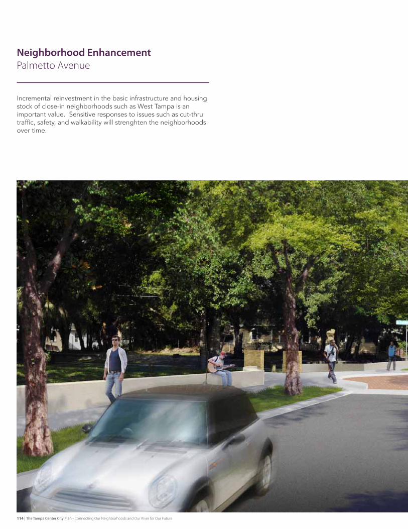
Neighborhood Enhancement Palmetto Avenue
Incremental reinvestment in the basic infrastructure and housing stock of close-in neighborhoods such as West Tampa is an important value. sensitive responses to issues such as cut-thru traffic, safety, and walkability will strenghten the neighborhoods over time.
114 | The Tampa Center City Plan - Connecting Our Neighborhoods and Our River for Our Future
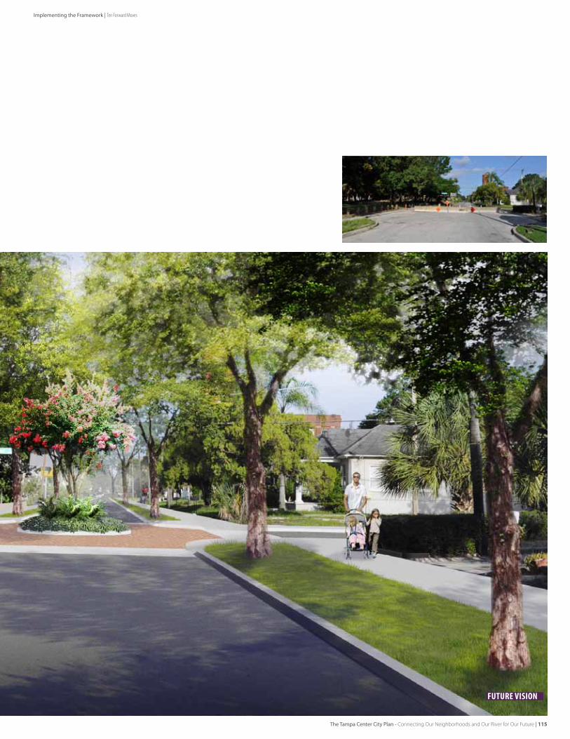
Future Vision
Implementing the Framework | Ten Forward Moves
The Tampa Center City Plan - Connecting Our Neighborhoods and Our River for Our Future | 115
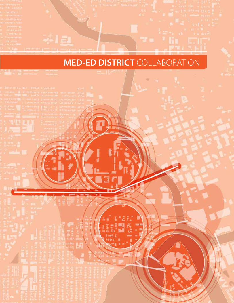
MED-ED DISTRICT COLLAbORATION
116
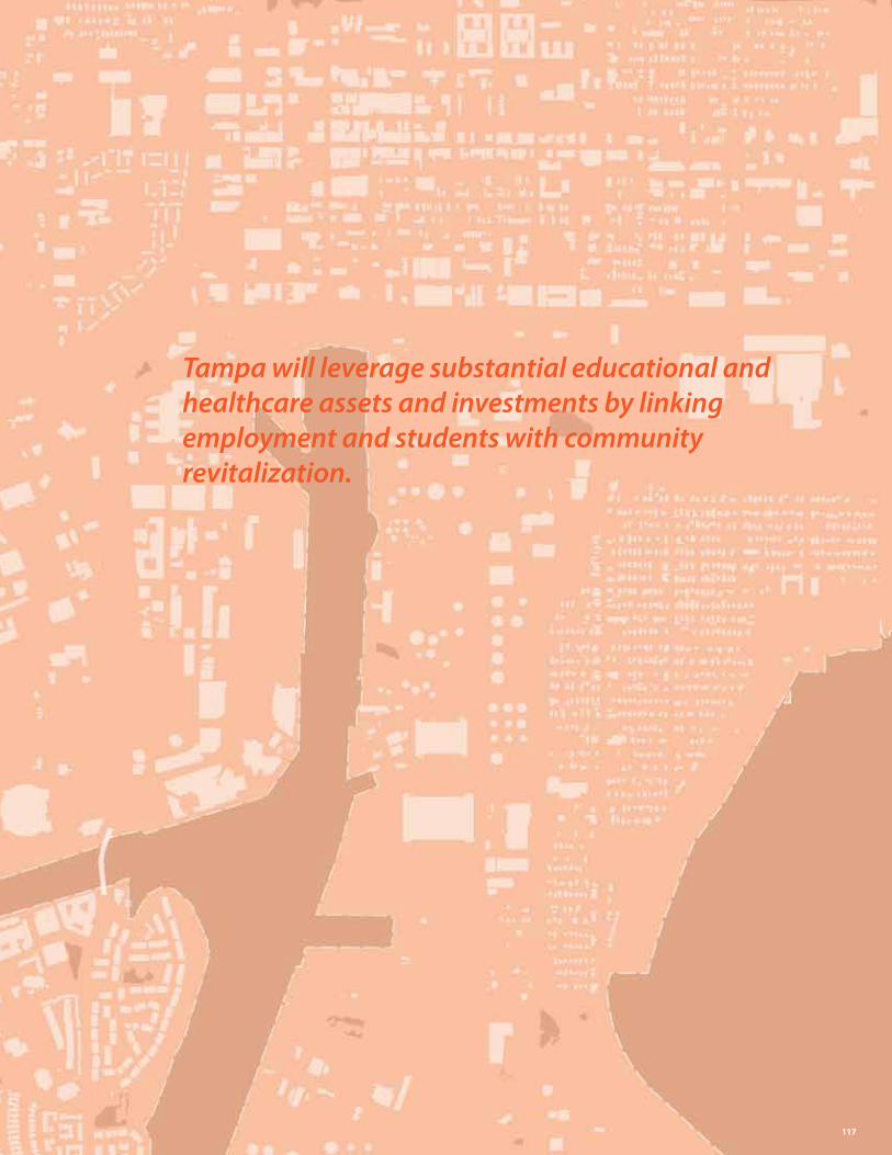
Tampa will leverage substantial educational and healthcare assets and investments by linking employment and students with community revitalization.
117
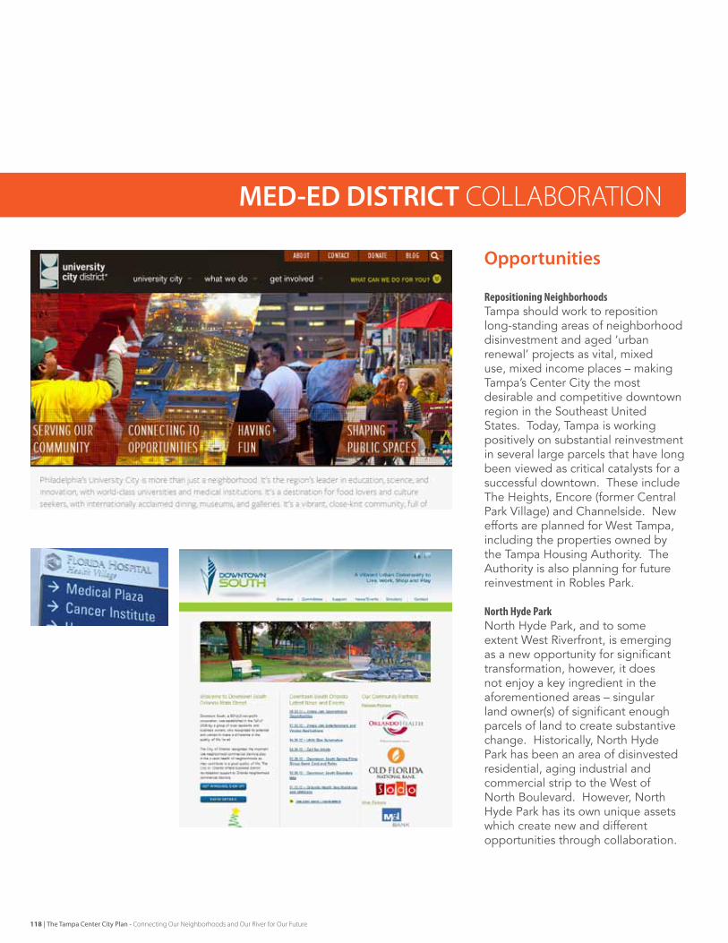
Opportunities
RepositioningNeighborhoodsTampa should work to reposition long-standing areas of neighborhood disinvestment and aged ‘urban renewal’ projects as vital, mixed use, mixed income places – making Tampa’s Center City the most desirable and competitive downtown region in the southeast united states. Today, Tampa is working positively on substantial reinvestment in several large parcels that have long been viewed as critical catalysts for a successful downtown. These include The Heights, encore (former Central Park village) and Channelside. New efforts are planned for West Tampa, including the properties owned by the Tampa Housing Authority. The Authority is also planning for future reinvestment in robles Park.
NorthHydeParkNorth Hyde Park, and to some extent West riverfront, is emerging as a new opportunity for significant transformation, however, it does not enjoy a key ingredient in the aforementioned areas – singular land owner(s) of significant enough parcels of land to create substantive change. Historically, North Hyde Park has been an area of disinvested residential, aging industrial and commercial strip to the West of North Boulevard. However, North Hyde Park has its own unique assets which create new and different opportunities through collaboration.
MED-ED DISTRICT COLLAbORATION
118 | The Tampa Center City Plan - Connecting Our Neighborhoods and Our River for Our Future
Key Actions
LeveragingDiverseInstitutionsTampa should leverage the activities of institutions, community groups, residential developers and business areas to create a vibrant and diverse North Hyde Park. Today, university of Tampa, Tampa Preparatory Academy and Tampa general Hospital have grown to new levels of size, quality and economic impact. Their development, recreation and cultural activities have increased the activity along the West Bank of the Hillsborough river and adjacent urban areas. They are also beginning to assemble property along West kennedy Boulevard to meet growth needs because their current facilities are becoming land locked.
Partly in response to this activity, new residential investment is occurring to provide housing for students, young professionals and area workforce. Industrial properties are being converted to high quality home furnishings or utilizing inexpensive space for start up operations. New community groups are organizing and developing frameworks for a North Hyde Park neighborhood plan and a voice for preliminary ideas.
CapitalizingonSharedInterestsTampa should capitalize on these ingredients for success to develop a new community development district which can provide organized planning, investment and incentives for the area – and mutual benefit to all parties. Because of the presence of the institutions, and their large associated populations, there is a synergy between employment, retail and residential and infrastructure investment that can be coordinated similarly to the ‘university City district’ in Philadelphia, the ‘John’s Hopkins Neighborhood fund’ in Baltimore, or the neighborhood improvement efforts currently underway in downtown orlando via orlando Health and florida Hospital. A formally or informally branded ‘med-ed’ district can provide valuable coordination and funding alternatives to link employment to residential investment, incentive programs to ‘live where you work’ and needed infrastructure. The outcome can be residential and commercial investment, economical vitality and a transit supportive place.
from this beginning, other proximate development should be attracted. start up, light industry and ‘clean tech’ businesses can be incentivized to take advantage of the large lot industrial properties on Willow and rome Avenues. This business development might be assisted with a business incubator program that could involve one or more of the downtown universities. New retail can be supported, providing daily needs, independent retailing and ‘sparkle’ shopping. And new forms of residential and office / mixed use will be attracted, ranging from affordable options in the neighborhood to potentially high value properties near the Hillsborough river and west riverwalk.
As North Hyde Park develops, its inherent and enhanced linkages to West Tampa, Hyde Park and the downtown Core should complete the neighborhood development in Center City, and allow Tampa to fulfill its potential as the river City of choice.
EarlyActionsAlreadyUnderway[1] Leverage large scale investments currently underway by UT and
TGH[2] Recruit additional multifamily infill residential opportunities for
key sites[3] Support incremental neighborhood investment with grassroots
incentives[4] Support active Neighborhood Planning
EarlyNextSteps[5] Leverage large institutions and grassroots efforts to create
an organization and funding structure for North Hyde Park community investment and home ownership
[6] Develop a program of incremental infrastructure enhancements[7] Create program for homeowner and small business investments[8] Pursue an east-West Transit connection, that can eventually be
expanded to the North[9] Support the West Side Riverwalk trail and expand access to the
River from North Hyde Park and West Tampa[10] Support the Green Spine trail concept[11] market the medical and educational corridors of West Tampa [12] explore the feasibility of a business incubator with downtown
institutions
The Tampa Center City Plan - Connecting Our Neighborhoods and Our River for Our Future | 119
Implementing the Framework | Ten Forward Moves
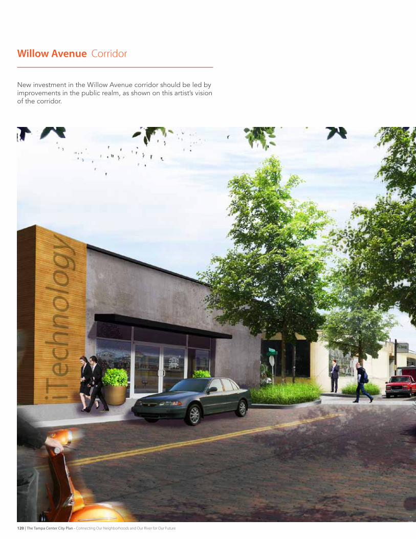
Willow Avenue Corridor
New investment in the Willow Avenue corridor should be led by improvements in the public realm, as shown on this artist’s vision of the corridor.
120 | The Tampa Center City Plan - Connecting Our Neighborhoods and Our River for Our Future
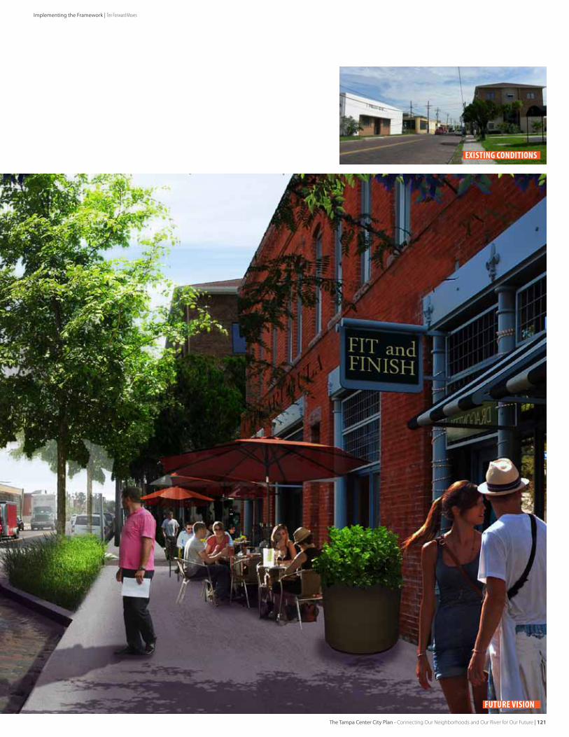
existing conditions
Future Vision
The Tampa Center City Plan - Connecting Our Neighborhoods and Our River for Our Future | 121
Implementing the Framework | Ten Forward Moves
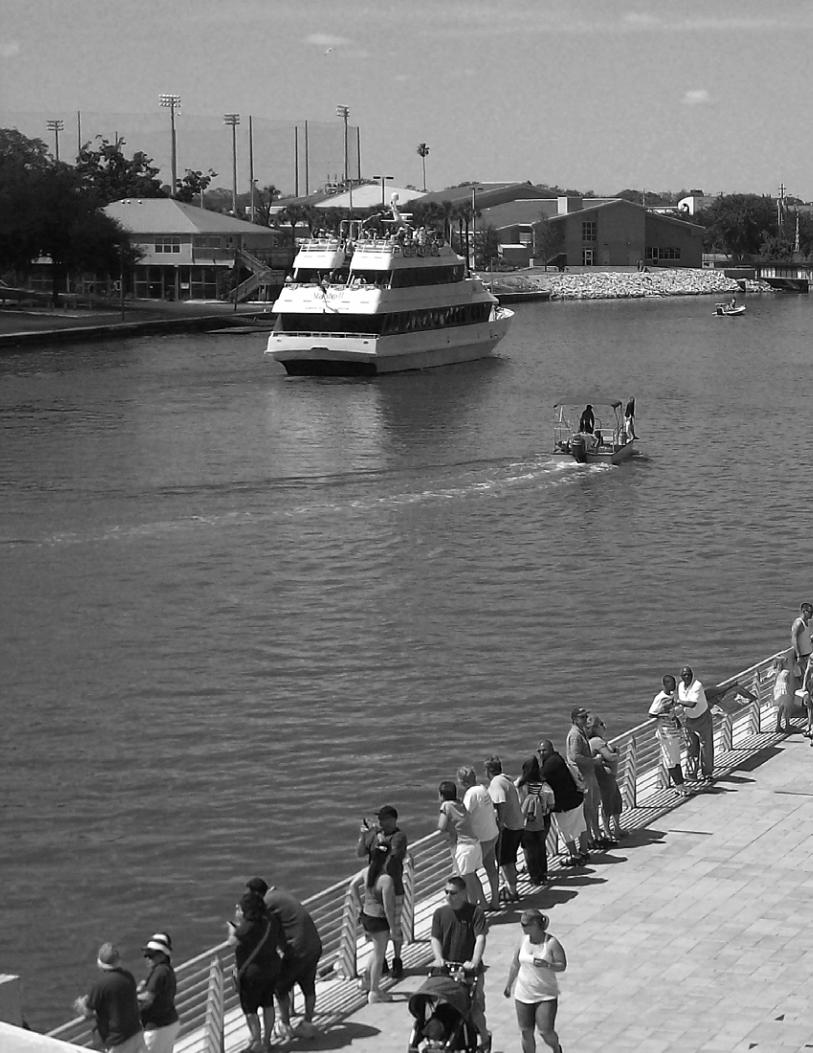
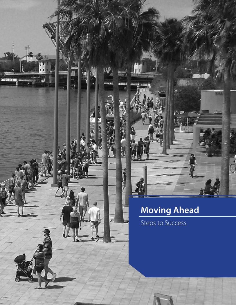
Moving AheadSteps to Success
Moving Ahead
The Invision Tampa effort has been focused on facilitating a community conversation about Tampa’s future with specific input, new directions and actionable ideas. The vision is to be more diverse, more connected and more livable as the sustainable response to evolving cultural and economic opportunities. The Building Blocks provide an approach to community planning as clear response to specific input. The Forward Moves are concepts, based on community interaction and direct observation, for initiatives the community could pursue to manifest certain ideas embedded in the Blocks. Over time, there can be many more Moves.
Alignment Many of the ideas in the plan already reside in the minds of some members of the community. However, not all members of the community are aware of the concept and therefore do not have the opportunity to be aligned to a general purpose, if not the specific details. In some cases, prior ways of thinking should be opened up to new ideas. Anecdotes from the 1980’s inception of the Riverwalk indicate skepticism in the face of so many technical, political, and funding obstacles. However, the Riverwalk is proceeding towards completion, because the broad community understands the idea, supports the broad idea, and considers it when making incremental decisions. Going forward, Tampa should filter new incremental decisions through the lens
of the Vision and the principles of the Building Blocks.
LeveragingInvestmentsMany elements of the Plan directly address the fact that many areas of the City are not fully configured to support the vision for the future. Challenges from sidewalks to storm drainage to superblocks abound. Property ownership involves many players. Yet, as each individual investment takes place, the opportunity to solve proximate joint issues should be explored. This may mean reservation of easement for access or open space associated with a private development, or a limited but meaningful restriping of a street when a utility line must be opened for basic maintenance. The potential for shared use and flexible places ranges from workplace cooperatives and open space to popup retail and parking.
PartnershipsThe challenges in Center City are significant, yet there are many areas where activities, people and institutions come together to make great places and dynamic economic opportunity. The downtown, riverfront address is a differentiator and if the plan is successful, everyone can benefit from it. But to realize the value of the waterfront City, agencies that have a stake in the future of the city and region must work together towards common goals, taking ownership of their share of opportunity and in their potential to support an enhanced the outcome.
The public, private, and institutional sectors need each other. Successful regions recognize the importance of a strong downtown address. Progressive cities are moving from a posture of regulation to one of constructive facilitation. Enlightened private developers and institutions are sensitive to the contribution their investment makes to the whole, and realize value over the long term by reaching beyond their boundaries to provide stability and enhancement to the shared surroundings.
ChampionsTo achieve results, committed leaders need to advance the effort with energy and support to succeed. Tampa is fortunate to have many organizational entities that are invested in the future of the city for the long term. The Tampa Downtown Partnership, Friends of the Riverwalk, redevelopment agencies, cultural groups, universities, private entities, foundations, faith-based, and neighborhood organizations are but a few of the groups that participated in the plan and provide significant leadership to Center City. A “grassroots and grasstops” understanding of the City’s future is key to creating energy, marketing the story, and achieving results over time. Tampa has the social capital to achieve its vision. Significant accomplishments are already in place, with plenty of windows providing glimpses of a future that will be nationally-recognized and locally-cherished.
““In our journey to rediscovering our riverfront, we learned that cities, like forests, are in a constant state of renewal. While forests cycle in rhythm with natural laws, the city is recycled by the collective will and conscience of its citizens” – Stroud Watson [Chattanooga Riverfront Downtown Design Center Director] Remarks at InVision Tampa Knowledge Share 3
124 | The Tampa Center City Plan - Connecting Our Neighborhoods and Our River for Our Future
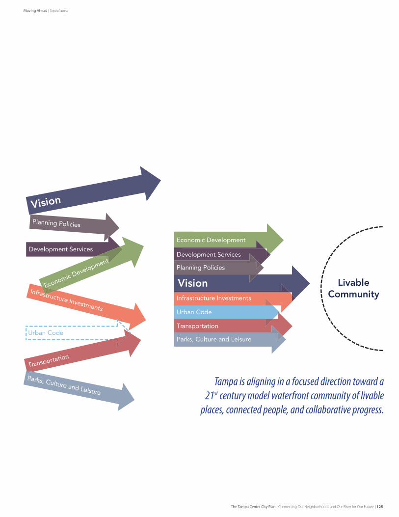
Tampa is aligning in a focused direction toward a 21st century model waterfront community of livable
places, connected people, and collaborative progress.
LivableCommunityInfrastructure Investments
Urban Code
Vision
Development Services
Economic Development
Transportation
Planning Policies
Parks, Culture and Leisure
Infrastructure Investments
Urban Code
Vision
Development Services
stEconomic Development
Transportation
Planning Policies
Parks, Culture and Leisure
The Tampa Center City Plan - Connecting Our Neighborhoods and Our River for Our Future | 125
Moving Ahead | Steps to Success