The Tagliamento River: A model ecosystem of European...
15
Overview Article The Tagliamento River: A model ecosystem of European importance Klement Tockner 1, *, James V. Ward 1 , David B. Arscott 1 , Peter J. Edwards 2 , Johannes Kollmann 3 , Angela M. Gurnell 4 , Geoffrey E. Petts 5 and Bruno Maiolini 6 1 Department of Limnology, EAWAG/ETH, Überlandstr. 133, CH-8600 Dübendorf, Switzerland 2 Geobotanical Institute, ETH, CH-8044 Zürich, Switzerland 3 Department of Ecology, Royal Veterinary and Agricultural University, Copenhagen, Denmark 4 School of Geography, University of Birmingham, Birmingham B15 2TT, U.K. 5 King’s College, London, U.K. 6 Museo Tridentino di Scienze Naturali, I-38100 Trento, Italy Received: 21 May 2003; revised manuscript accepted: 21 July 2003 Abstract. In NE Italy is a remarkable floodplain river that retains the dynamic nature and morphological com- plexity that must have characterized most Alpine rivers in the pristine stage. This river system, the Fiume Taglia- mento, constitutes an invaluable resource not only as a reference site for the Alps, but as a model ecosystem for large European rivers. The Tagliamento has a number of attributes that have not been given due consideration in river ecology: (i) an immense corridor of more than 150 km 2 that connects the land and the sea and two biomes, Aquat. Sci. 65 (2003) 239 – 253 1015-1621/03/030239-15 DOI 10.1007/s00027-003-0699-9 © EAWAG, Dübendorf, 2003 Aquatic Sciences the Alps and the Mediterranean; (ii) unconstrained flood- plain segments characterised by a dynamic mosaic of aquatic/terrestrial habitats; and (iii) a large number of vegetated islands (ca. 700). We believe it is critical to un- derstand the functional roles of these endangered attrib- utes in order to effectively engage in river conservation and management programmes. The Tagliamento River in Italy offers the rare opportunity to investigate natural processes at a scale that can be studied almost nowhere else in Europe. Key words. Floodplain; restoration; conservation; landscape; biodiversity; flow pulse; flood pulse; reference ecosystem. Introduction Gravel-bed rivers are characterised by their dynamic na- ture, by alluvial deposits containing groundwater aquifers, and by geomorphic features that include exten- sive flood plains (Billi et al., 1992 ). Braided gravel-bed rivers are widespread in temperate piedmont and moun- tain-valley environments. Today, in much of the world, however, gravel-bed rivers bear little resemblance to their highly dynamic natural state (Tockner and Stanford, 2002). The primary features that characterise gravel-bed rivers are often the ones most strongly influenced by hu- man intervention. In Europe, for example, almost all large Alpine rivers were “trained” during the first half of the 20 th century, in many cases over 100 years ago (Petts et al., 1989; Dynesius and Nilsson, 1994; Plachter, 1998). The remaining natural and semi-natural remnants, less than 10% of the total river length, are primarily located in the uppermost headwaters (Martinet and Dubost, 1992; CIPRA, 1998). A recent survey of all Austrian rivers with a catchment area of > 500 km 2 showed that formerly braided and meandering sections have been particularly affected by regulation (Muhar et al., 1998). At present, 25% of confined river sections, but only 1% of braided and meandering sections, remain intact. * Corresponding autho phone: + 41 1 823 5616 or 51 72; fax: + 41 1 823 53 15; e-mail: [email protected] Published on Web: ■ AS 699
Transcript of The Tagliamento River: A model ecosystem of European...

Overview Article
The Tagliamento River:A model ecosystem of European importanceKlement Tockner 1, *, James V. Ward 1, David B. Arscott1, Peter J. Edwards2, Johannes Kollmann3,Angela M. Gurnell 4, Geoffrey E. Petts 5 and Bruno Maiolini 6
1 Department of Limnology, EAWAG/ETH, Überlandstr. 133, CH-8600 Dübendorf, Switzerland2 Geobotanical Institute, ETH, CH-8044 Zürich, Switzerland3 Department of Ecology, Royal Veterinary and Agricultural University, Copenhagen, Denmark4 School of Geography, University of Birmingham, Birmingham B15 2TT, U.K.5 King’s College, London, U.K.6 Museo Tridentino di Scienze Naturali, I-38100 Trento, Italy
Received: 21 May 2003; revised manuscript accepted: 21 July 2003
Abstract. In NE Italy is a remarkable floodplain riverthat retains the dynamic nature and morphological com-plexity that must have characterized most Alpine rivers inthe pristine stage. This river system, the Fiume Taglia-mento, constitutes an invaluable resource not only as areference site for the Alps, but as a model ecosystem forlarge European rivers. The Tagliamento has a number ofattributes that have not been given due consideration inriver ecology: (i) an immense corridor of more than 150km2 that connects the land and the sea and two biomes,
Aquat. Sci. 65 (2003) 239–2531015-1621/03/030239-15DOI 10.1007/s00027-003-0699-9 © EAWAG, Dübendorf, 2003
Aquatic Sciences
the Alps and the Mediterranean; (ii) unconstrained flood-plain segments characterised by a dynamic mosaic ofaquatic/terrestrial habitats; and (iii) a large number ofvegetated islands (ca. 700). We believe it is critical to un-derstand the functional roles of these endangered attrib-utes in order to effectively engage in river conservationand management programmes. The Tagliamento River inItaly offers the rare opportunity to investigate naturalprocesses at a scale that can be studied almost nowhereelse in Europe.
Key words. Floodplain; restoration; conservation; landscape; biodiversity; flow pulse; flood pulse; reference ecosystem.
Introduction
Gravel-bed rivers are characterised by their dynamic na-ture, by alluvial deposits containing groundwateraquifers, and by geomorphic features that include exten-sive flood plains (Billi et al., 1992 ). Braided gravel-bedrivers are widespread in temperate piedmont and moun-tain-valley environments. Today, in much of the world,however, gravel-bed rivers bear little resemblance to theirhighly dynamic natural state (Tockner and Stanford,2002). The primary features that characterise gravel-bed
rivers are often the ones most strongly influenced by hu-man intervention. In Europe, for example, almost alllarge Alpine rivers were “trained” during the first half ofthe 20th century, in many cases over 100 years ago (Pettset al., 1989; Dynesius and Nilsson, 1994; Plachter, 1998).The remaining natural and semi-natural remnants, lessthan 10% of the total river length, are primarily located inthe uppermost headwaters (Martinet and Dubost, 1992;CIPRA, 1998). A recent survey of all Austrian rivers witha catchment area of >500 km2 showed that formerlybraided and meandering sections have been particularlyaffected by regulation (Muhar et al., 1998). At present,25% of confined river sections, but only 1% of braidedand meandering sections, remain intact.
* Corresponding autho phone: +41 1 823 5616 or 51 72;fax: +41 1 823 53 15; e-mail: [email protected] on Web: ■
AS 699

In NE Italy there is a remarkable gravel-bed river thatretains the dynamic nature and morphological complex-ity that must have characterised many Alpine rivers in thepristine stage. This river system, the Fiume Tagliamento,is considered as the last morphologically intact river inthe Alps (Lippert et al., 1995; Müller, 1995; Ward et al.,1999b) and, therefore constitutes an invaluable resource,not only as a reference ecosystem for the Alps but also asa model ecosystem for large temperate rivers. The Taglia-mento has a number of attributes that have not been givendue consideration in river ecology: (i) an immense corri-dor of more than 150 km2 that connects the land and thesea and two biomes, the Alps and the Mediterranean(Ward et al., 1999b); (ii) unconstrained floodplain seg-ments characterised by a dynamic mosaic of aquatic/ter-restrial habitats (Tockner and Ward, 1999; Gurnell et al.,2000a, b; Van der Nat et al., 2002; Arscott et al., 2002);and (iii) a large number of vegetated islands (Edwards etal., 1999; Kollmann et al., 1999; Ward et al., 2000; Gur-nell et al., 2001). We believe it is critical to understand thefunctional roles of these endangered attributes in order toeffectively engage in river conservation and managementprogrammes.
The following text begins with a general descriptionof the environmental setting of the region. This is fol-lowed by information of the Tagliamento catchment, in-cluding hydrological conditions and human impacts. Theremaining of the text focuses on the river corridor specif-ically, including geomorphic features, physico-chemicalconditions, and the longitudinal distribution of plants,terrestrial invertebrates and fishes. The formation, distri-bution, and potential role of islands are treated in somedetail.
Environmental setting
The ‘Fiume Tagliamento’ is the dominant river system ofthe Friuli region in northeastern Italy (Cattaneo et al.,1995; Fig. 1). From north to south (a linear distance of<100 km), the Tagliamento traverses four major regions:(i) the Julian and Carnian Alps, (ii) prealps, (iii) the upperand lower Friulian plain, and (iv) the coast. This steep en-vironmental gradient from north to south is associatedwith climatic differences; e.g., annual precipitationranges from 3,100 to 1,000 mm per year and mean annualtemperature from 5 to 14°C (Baumgartner et al., 1983;Poldini, 1991; Fig. 1). The southern fringe of the Carnianand Julian Alps frequently receives very intensive rain-storms, resulting in severe erosion, especially in thealpine area. Torrential rainfalls, steep slopes, and exten-sive sediment sources generate high floods and massivesediment transport rates. The frequent reworking of thevalley floor by floods constrains human habitation withinthe river corridor.
Geology and glacial historyThe alpine area of Friuli mainly consists of limestone,with a spatial sequence of Silurian, Devonian, Triassic,Jurassic and Cretaceous formations north to south (As-tori, 1993; Martinis, 1993). A precise delineation of thewatershed of the Tagliamento is almost impossible due tothe high complexity of groundwater drainage through thelimestone karst. Limestone is occasionally intermixedwith layers of gypsum that lead to high sulphate concen-trations in the Tagliamento (Arscott et al., 2000). Thecatchment is tectonically active, continuously developingfaults and overthrusts. Many tributary streams, like theFella, have sharp bends following the direction of thesefaults (Fig. 2).
The prealpine mountains mainly consist of limestone(Jurassic-Cenozoic) and Flysch s.s. (calcareous flysch,molasse). The Friulian plain consists primarily of Tertiaryand Quaternary sediments. The upper plain consists of avast alluvial aquifer several hundred meters deep, and iscomposed of fluvioglacial sediments of high permeabil-ity (Ward et al., 1999b). To the south the aquifer sedi-ments are intermixed with layers of marine deposits (sandand clay), which reduce permeability and result in up-welling of groundwater (‘Linea delle risorgive’, see: Fig. 1).
The lowest glaciers of the Eastern Alps are located inthe Julian Alps on the northern slopes of Mt. Canin (2587m a.s.l.), with the termini of the glaciers at altitudes < 2000 m a.s.l. Within the last decades, however, theglaciated area has decreased from about 10 km2 to 3 km2
(Mosetti, 1983). Harsh environmental conditions also are
240 K. Tockner et al. A model ecosystem
Figure 1. Climatic setting of the Tagliamento catchment within theregion of Friuli-Venezia Giulia, Italy. Average annual precipitation(1951–1970) is given by isohyets in mm. 1: Alps and prealps; 2: Upper Friulian plain; 3: Glacial moraines; 4: Lower Friulian plain;5: Karstic area (Based on Regione Autonoma Friuli-Venezia Giulia,1982).
reflected by the position of the tree line at about 1500 ma.s.l., 300–500 m lower than in the central Alps (Gentilli,1971).
PhytogeographyThe steep environmental gradient from the Alpine regiontowards the Adriatic Sea is reflected in floristic distribu-tion patterns. Arctic-alpine species dominate the uppercatchment, some of which (e.g., Adenostyles glabra, Al-nus viridis, Arabis alpina or Soldanella alpina) havenever been found in the middle or lower reaches of theTagliamento (Poldini, 1991; nomenclature follows Tutinet al., 1964–1980). Some arctic-alpine species are geo-graphically limited either by poor dispersal of seeds (e.g.,Valeriana saxatilis) or by specific habitat requirements(e.g., Trollius europeus). In contrast, the (sub)mediter-ranean species mainly occur in lower sections of the
Tagliamento catchment (e.g., Cucubalus baccifer, Orchislaxiflora, Platanus hybrida and Populus alba). Thesespecies are most prominent in SE Friuli, but have neverreached the upper catchment of the Tagliamento.
Overall, there are marked differences in floral rich-ness along the Tagliamento (Poldini, 1991). In the UpperTagliamento valley, the number of vascular species(based on 11 ¥ 13 km2 plots) is between 500 and 800. Thehighest species richness (1100–1200 species per plot)was found between Amaro and Cornino (for location seeFig. 2) where the river leaves the Alps; this is mainly aconsequence of the co-occurrence of Alpine and lowlandspecies. Additionally, the number of endemic species israther high in this part of the catchment (5–12 spp. perplot). Further downstream, the species number decreasesfrom the Alpine foothills (700–900) towards the AdriaticSea (300–500).
Aquat. Sci. Vol. 65, 2003 Overview Article 241
Figure 2. Catchment map of the Tagliamento, with major tributaries and towns. Inset shows the location of the river in Italy (I), near theborders of Austria (A) and Slovenia (SL) (modified after Ward et al., 1999b).

Catchment descriptionThe Tagliamento is a 7th order river (46° N, 12°30¢ E; Fig. 2) that flows unimpeded by high dams for 172 km tothe Adriatic Sea. The Tagliamento drains an approxi-mately 2580 km2 area. It is a mountainous river with morethan 70% of the catchment located in the Alpine area. Thehighest peak in the catchment is Mt. Coglians (2781 ma.s.l.). The mean altitude of the catchment is 987 m a.s.l.Areas above 1000 m a.s.l. (ca. 50% of the Tagliamentocatchment), are practically uninhabited (Steinicke, 1991).
The total stream network length for the entire catch-ment is 2726 km, corresponding to an average streamdensity of 0.85 km km–2 (Table 1). First and second orderstream segments account for 75% of total length and 95%of all stream segments, respectively. Most of these low or-der segments are intermittent and dry at the surface dur-ing low flow periods in winter and summer (Hormann,1964).
HydrologyThe Tagliamento is characterised by a flashy pluvio-nivalflow regime (Fig. 3a), with an average discharge of ca. 90m3 s–1 at Pioverno. The 2, 5 and 10 year floods are esti-mated to be 1100, 1600 and 2150 m3 s–1 (Maione andMachne, 1982). Mosetti (1983) calculated an average to-tal annual discharge (1929–1939) of 3.83 km3 at Pioverno(range: 2.64–5.18 km3, catchment area: 1900 km2), and4.72 km3 at Pinzano (2300 km2). As described above, theTagliamento is influenced by both Alpine and Mediter-ranean snowmelt and precipitation regimes. As a result, itexhibits a bimodal flow pattern with peaks in spring andautumn (Fig. 3b).
In unconfined floodplain sections, maximum annualamplitudes of surface water levels are about 2 m (Fig.3a). Even small fluctuations in discharge, however, leadto marked areal expansions and contractions of surfacewaters, a characteristic of many alluvial rivers (Tockneret al., 2000; Van der Nat et al. 2002). In the artificially-constrained section downstream of Latisana, however,water level fluctuations of ≥7 m occur.
Downstream of Pinzano, the Tagliamento loses a largepercentage of its surface flow by infiltration through avast alluvial aquifer dominated by highly permeablegravel (average porosity 10%). Under low flow condi-tions, the river here lacks surface flow (maximum drylength: 20 km). This is a natural feature of Mediterraneanrivers that has been exacerbated by water abstraction. Inthis section water drains into the alluvial aquifer throughthe river bed (on average ~3 m3 s–1 per river km; D.Schlaepfer and A. Rotach, pers. comm.) and, althoughsome of this water returns to the river in its downstreamsections (~0.3 m3 s–1 per river km), much is lost to adja-cent catchments. For example, the Fiume Stella located tothe east of the Tagliamento receives a major portion of its
242 K. Tockner et al. A model ecosystem
Table 1. Number, total and average lengths (km) of stream segments of each stream order (Strahler order system) in the Tagliamento catch-ment (based on the analysis of information derived from a map produced by Carta Idrographica, 1994).
Stream order Number of Total stream Average length ofstream segments segment length (km) stream segment (km)
1 1,663 1,405 0.842 416 631 1.523 90 320 3.564 21 155 7.385 6 85 14.176 2 16 8.007 1 114 114.00
Total 2,199 2,726 –
Figure 3. A: Hydrograph of the Tagliamento in 1995 (at Pinzano).B: Seasonal flow patterns (probability curves, in %, for 1921–1977;Electroconsult, 1979).

discharge from Tagliamento water draining through thealluvial aquifer (Ward et al., 1999b).
Human impactsAlthough the Tagliamento is considered to be the mostnatural river system in the Alps, it is not without humanimpacts. Major human influences on the main river corri-dor are (i) water abstraction in the upper Tagliamento val-ley, (ii) organic pollution, and (iii) gravel exploitation.Many small tributaries contain drop structures to inhibiterosion and channel incision (Stefanini, 1982). Water isabstracted for hydropower generation in the upper area,altering the flow regimes of the Degano, the Lumiei, andsections of the main stem Tagliamento (Table 2). Down-stream of the weir at Caprizzi (for location see Fig. 2), theTagliamento frequently loses surface flow over a distanceof 25 km. Additionally, a maximum of 23 m3 s–1 is ab-stracted for irrigation purposes at Ospedaletto south ofPioverno (Canale Ledra). Nevertheless, large tributarieslike the Fella, But and Arzino are characterised by a nat-ural flow regime. In addition, the flood dynamics of themain stem of the Tagliamento is largely unaffected by wa-ter abstraction. The Tagliamento suffers from organic pol-lution between Tolmezzo and its confluence with theFella, and in the chanalised section downstream of Lati-sana; however, water quality has improved considerablyin recent years (Provincia di Udine, 1997). There are lat-eral dams along some sections (e.g. between Piovernoand Pinzano; and downstream of Dignano). However,they are far outside the active corridor and primarily usedto protect agricultural land.
The Corridor
The river corridor, which is morphologically intact alongvirtually its entire length, is the feature that makes theTagliamento unique in the Alps. The corridor has escapedmassive river engineering and floodplain development
schemes, thus retaining the functional characteristics of anear-pristine system: strong longitudinal, lateral and ver-tical connectivity, high habitat heterogeneity, and a char-acteristic sequence of geomorphic types.
Geomorphological DiversityThe riparian corridor consists of five major landscape el-ements: surface water, bare gravel, vegetated islands, ri-parian forest and topographical low areas that are un-forested (Table 3). The first three landscape elementsform the active corridor with a total area of 61.7 km2. Theriver retains an intact riparian margin, with a total area of32 km2, throughout almost its entire length. Considerableparts of topographically low areas, adjacent to the mean-dering and regulated sections in particular, are underother land uses, primarily agriculture. These lowland ar-eas tend to be situated on the more stable terraces alongthe edges of the corridor, although they are partly inun-dated during major floods. In summary, the riparian cor-ridor of the Tagliamento is about 150 km2 (excluding trib-utary corridors), comparable in size to some of Europe’snational parks such as the Alluvial Zone National Park,Austria (93 km2), the Swiss National Park (169 km2), andthe National Park “Neusiedlersee”, Austria, (200 km2).
The active zone of the Tagliamento reaches a maxi-mum width of about 2 km in the upper part of the coastalplain section (Fig. 5). In some reaches the river dividesinto more than 10 channels with a maximum shorelinelength of 22 km · km–1 and a total shoreline length alongthe entire river corridor of 940 km at around mean waterlevel (based on an analysis of 1:10,000 scale maps).Shoreline length influences species diversity and speciesdensity of both aquatic and terrestrial communities. In theTagliamento, Reich (1994) found a positive relationship
Aquat. Sci. Vol. 65, 2003 Overview Article 243
Table 2. Mean flow (MQ, m3 s–1), diverted flow and residual flowin the Tagliamento and in major tributaries (L. Tonus, pers. comm.).
MQ Diverted Q Residual Q(m3s–1) (m3s–1) (m3s–1)
Tagliamento (Forni di Sopra) 1.8 1.2 0.6Tagliamento (Forni di Sotto) 5.4 1.7 3.7Tagliamento (Caprizzi) 9.6 8.0 1.6Lumiei 2.9 2.9 0.0Degano 12.1 10.0 2.1Tagliamento (Invillino) 25.6 21.1 4.5But 16.3 0.0 16.3Fella 37.6 0.0 37.6Tagliamento (Pioverno) 87.3 21.1 66.2
Table 3. The river corridor of the Tagliamento: Summary statisti-ics (modified after Ward et al., 1999a, b; Gurnell et al., 2000a).
Active corridor area 61.7 km2
Gravel area (excl. Water) 38.7 km2
Island area 10.6 km2
Water area 12.4 km2
Riparian forest area1 32.0 km2
Riparian corridor area2 ≥150 km2
Number of gravel bars 950Number of islands 3 652Length of riparian ecotone 4 670 kmLength of shoreline 940 km
1 Marginal band of riparian woodland which is periodically re-worked by lateral displacement of the active zone (Gurnell et al.,2000a).2 The riparian corridor includes the active zone, the riparian forestarea, and the topographically low area on either side of the river (toa maximum of 2 km).3 Vegetated islands of >0.01 ha. 4 Including the perimeter of islands and the riparian zone along thelateral flood plain (Ward et al., 1999b).

between shoreline length and the number of breedingpairs of Charadrius dubius (Little Ringed Plover), withup to 22 breeding pairs per river-km. Along the DanubeRiver (Austria), Wintersberger (1996) demonstrated thatspecies diversity of 0+ fish was significantly related toshoreline length.
The complex downstream variability in river dis-charge and sediment transport regimes, the local hy-draulic conditions, and the materials within which thechannel is formed have resulted in a high diversity of ge-
omorphological styles of river planform along the rivercorridor. Figure 6 illustrates that at least six geomorpho-logical styles are present, ranging from single threads toa variety of multiple thread patterns. A particular charac-teristic of the Tagliamento is the large number of islands.In some reaches (Fig. 5, class 6 in Fig. 6) more than 50%of the area of the active zone is covered by vegetated is-lands. Another important point is that the full complexityof channel planform is not fully represented in Figure 6because there is considerable variety within the single
244 K. Tockner et al. A model ecosystem
Figure 4. The Tagliamento after leaving the Alps near Gemona (Photo: K. Tockner)
C
Figure 5. Distribution of four major landscape elements along theriver corridor (based on the analysis of information derived from1:10000 scale maps, 1984–1985) (Gurnell et al., 2000a).
Figure 6. Variations in river channel geomorphological style alongthe Fiume Tagliamento. 0 = channelised; 1 = single thread; 2 = sin-gle thread with backwaters; 3 = braided; 4 = braided with occa-sional islands; 5 = island braided; 6 = highly island braided (basedon the analysis of information derived from 1:10000 scale maps;1984–1985).
thread category. Whereas single thread sections in theheadwaters have a low sinuosity as a result of their con-finement within narrow valleys and gorges, the short sin-gle thread sections within the central sections are lessconfined and are, therefore, able to develop a slightlyhigher sinuosity within the river corridor. The singlethread unconfined section in the downstream part of thecoastal plain section has a highly sinuous, meanderingcourse within this low gradient, unconfined, relativelyfine sediment environment.
Flow and flood pulsesFlooding represents the major physical disturbance alongriver corridors (flood pulses sensu Junk et al., 1989).Rivers also experience frequent but smaller water levelfluctuations (“flow pulses” sensu Tockner et al., 2000)that occur well below bankfull discharge. Although notresponsible for rapid morphological restructuring, theseflow pulses are important for creating and maintaininghabitat heterogeneity and for ecosystem processes(Benke et al., 2000; Arscott et al., 2002; Van der Nat et al.,2002).
Along the Tagliamento corridor, aquatic habitatchange caused by flooding was investigated in five dif-ferent reaches, ranging from near the headwaters to nearthe mouth (Arscott et al., 2002). The highest degree(62%) of aquatic habitat turnover occured in a braidedheadwater section. The degree of habitat turnover de-creased with decreasing elevation to ~20% in the mean-dering reach close to the mouth. In contrast to turnoverrate, braiding, sinuosity, and aquatic habitat compositionchanged little in response to flooding. Floods changed theconfiguration of floodplain habitats, whereas habitatcomposition and heterogeneity remained relatively sta-ble. These results support the applicability of the shiftingmosaic steady-state model to riverine flood plains (Bor-mann and Likens, 1979). These results also highlight theimportance of floods in maintaining habitat diversity indynamic flood plains.
We investigated inundation processes in a bar- and island-braided flood plain (Van der Nat et al., 2002). Despite complex inundation patterns, a linear relation be-tween water level and the arcsine square root of inundatedarea existed in both reaches. A second-order polynomialrelation existed between water level and shoreline length.Using these relations as simple predictive models, weconverted several years of water level data into predic-tions for degree of inundation and shoreline length. Sim-ulated degree of inundation strongly resembled the hy-drograph. Complete inundation of the active flood plainoccured 3–4 times per year; however, the degree of inun-dation was highly dynamic during most of the year. Sim-ulated shoreline length averaged 171 m ha–1 (12.8 kmkm–1) with a maximum of 197 m ha–1 (14.7 km km–1).
During major flood events, shoreline length decreased to28 m ha–1 (2.1 km · km–1). A braiding index and upstreamsurface hydrologic connectivity were positively related towater level, whereas total area of isolated waterbodieswas negatively related to water level (Van der Nat et al.,2002).
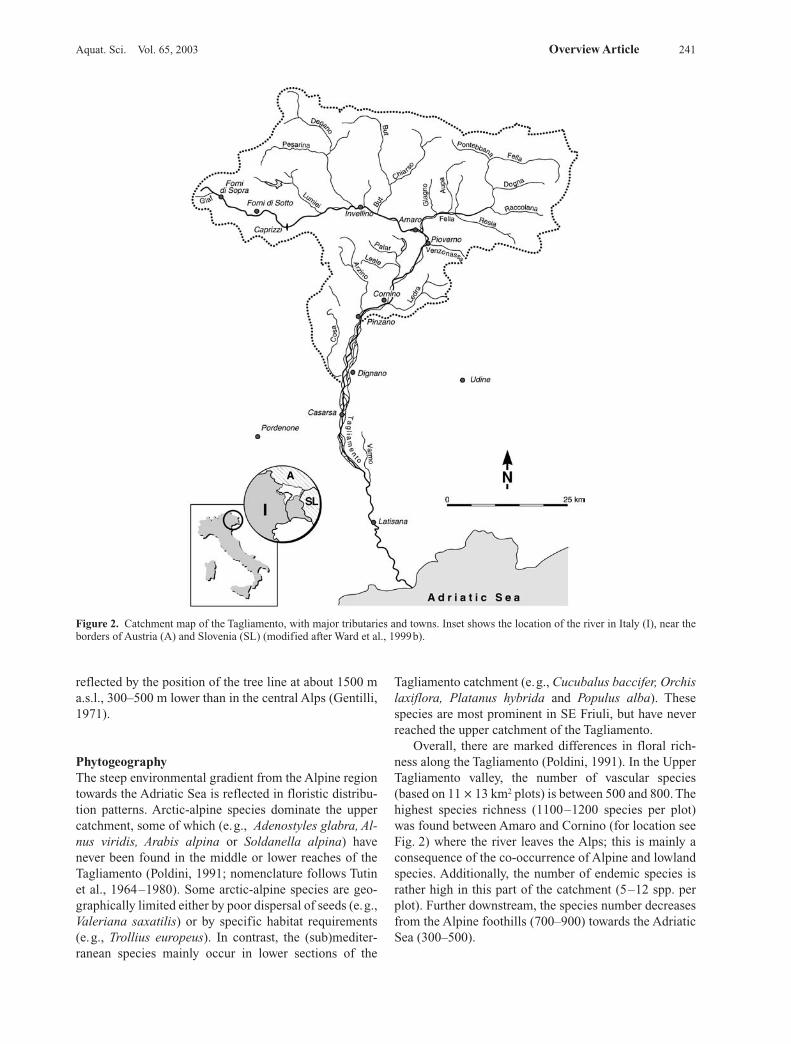
Structural diversityDifferent indicators of structural diversity may provide auseful approach for identifying ‘landscape filters’ thatoperate at different scales to influence biodiversity pat-terns across the riverine landscape. Tockner and Ward(1999) measured four different components of structuraldiversity (geomorphic, hydraulic, ecotonal and substrateheterogeneity) along the entire corridor (Fig. 7). Each ofthese indicators exhibited different longitudinal patterns.Fine scale heterogeneity (substratum heterogeneity)
Aquat. Sci. Vol. 65, 2003 Overview Article 245
Figure 7. Four indices of structural diversity along the river corri-dor (modified after Tockner and Ward, 1999). N.A. = not applica-ble. SD = standard deviation.

peaked in the headwater section and decreased with dis-tance from the source. Ecotone riparian length peaked inthe middle reaches. Stream power (hydraulic heterogene-ity) was highest in steep narrow headwater channels, inreaches where the valley was constricted by rock outcropsand alluvial fans, and at transitions between geomorpho-logic sections (e.g., multiple to single thread channel pat-terns). The number of links (geomorphic heterogeneity)was highest in the middle reaches where major tributariesenter the river. In the headwaters many small tributariesjoined the main stem but no tributaries enter the riverdownstream from river km 120 (Fig. 7). These simplescalar patterns of structural diversity may provide insightinto the mechanisms responsible for hierarchical arrange-ment of biodiversity in river corridors (Ward, 1998; Wardet al., 1999a; Ward and Tockner, 2001).
Physico-chemical characteristicsChemical composition of surface waters reflects the geo-logical setting of the catchment. The Tagliamento is clas-sified as an ‘alkaline river’ with a pH > 7.5, a specificconductance of > 250 mS cm–1 and a predominace of Ca2+
(about 100 mg L–1 upstream of the confluence with theFella River), Mg2+ (20 mg L–1) and HCO3
– (ca. 160 mgL–1). Along the river, specific conductance decreasedfrom 2000 mS cm–1 in the uppermost headwaters to about450 mS cm–1 in the lower reaches. High specific conduc-
tance mainly results from the weathering of evaporiticsediments (gypsum). Sulphate concentrations of up to ≥2000 mg L–1 are classified as extreme values compared tousual concentrations in perennial world rivers andstreams (Meybeck, 1996). Concentrations of phosphorusand ammonium were very low along the entire river. Con-centrations of nitrate (NO3-N), however, increased fromupstream to downstream with peak values of over 1.6 mgL–1. Dissolved organic carbon (DOC) concentrationswere relatively constant at about 1.0 mg L–1. Particulateorganic carbon (POC) ranged from 0.18 mg L–1 at lowflow to 12.1 mg L–1 during high flow (Table 4).
Longitudinal distribution and migration of plant speciesIt is likely that the active flood plain of the Tagliamentoserves as an important biogeographical corridor connect-ing the Alps with the Mediterranean zone near the Adri-atic Sea. We illustrate this function with a few examplesbased on plant species’ distribution. The phenomenon ofdownstream dispersal of Alpine plants (“alpine drifters”or “Alpenschwemmlinge”; Ellenberg, 1988) is wellknown. Bill et al. (1999) showed that the phenomenon ofdownstream dispersal is relevant on short distances, butprobably overestimated for long distance dispersal. Aclear example of “alpine drifters” is Gypsophila repenswhich actually follows the Tagliamento from the headwa-
246 K. Tockner et al. A model ecosystem
Table 4. Average physico-chemical concentrations of the Fiume Tagliamento main stem at discrete locations from its source near PassoMauria to 127.5 km. Cond. = Specific conductance, NH4-N = ammonium, NO3-N = nitrate, DN = dissolved nitrogen, PN = particulate ni-trogen, SRP = soluble reactive phosphorous, DON = dissolved organic nitrogen, DP = dissoveld phosphorous, PN = particulate phospho-rous, DOC and POC = dissolved and particulate organic carbon, SS = suspended solids, AFDM = ash-free dry mass, % OM = relative pro-portion of organic matter on SS, Chl.a = Chlorphyll-a concentration. (n = 7). nd = not detectable.
Variable km
0.0 0.9 1.5 13.3 73.7 80.3 120.0 127.5
PH 7.90 8.00 8.06 8.00 7.83 7.81 7.92 7.98Temp °C 8.27 9.53 9.81 10.36 13.94 14.74 16.41 15.69Cond mS 2010 1229 824 545 538 500 453 465NH4-N mg/l 4 4 2 2 3 30 2 4NO3-N mg/l 274 364 337 461 553 734 1041 1248DN mg/l 371 446 415 549 692 931 1184 1405PN mg/l 13 12 9 9 21 35 21 35DON mg/l 93 79 75 85 134 162 140 150SRP mg/l nd nd nd nd nd 4 nd NdDP mg/l 1 1 1 1 2 9 1 2PP mg/l 5 2 2 4 12 23 15 19DOC mg/l 1.1 1.0 0.9 1.1 0.9 0.8 0.7 0.9TIC mg/l 29.8 30.0 32.2 34.9 31.1 34.3 37.0 37.8POC mg/l 1.39 0.66 0.42 1.58 3.04 3.95 2.55 2.73SiO2 mg/l 4.64 3.17 3.18 2.95 3.16 3.40 3.64 4.12SO4 mg/l 979 545 347 171 168 126 94 101SS mg/l 20.07 9.04 5.13 18.57 33.77 65.81 56.71 59.54AFDM mg/l 3.43 2.20 1.88 2.65 4.43 5.78 4.70 5.34% OM % 16.3 22.55 30.66 47.22 26.34 22.72 36.50 29.52Chl.a mg/l 0.11 0.04 0.06 0.05 0.11 0.19 0.04 0.24

ter sections to the lower parts close to the Adriatic Sea(Poldini, 1991). Other vascular plants illustrating this pat-tern include Achnatherum calamagrostis, Globulariacordifolia, Linaria alpina or Satureja montana. Numer-ous Alpine species drift downstream during floods.
Different patterns of migration and distribution areexpected for neophytes that are rarely found in the Alpinezone (i.e., Amorpha fruticosa, Helianthus tuberosus,Oenothera biennis, Solidago gigantea and Parthenocis-sus quinquefolia). These species are most common in thelower parts of the catchment that are heavily used by agri-culture and harbour more ruderal species. Most neo-phytes, however, are unable to successfully invade intactnatural vegetation (Lohmeyer and Sukopp, 1992). Boththe neophytes and the Alpine drifters illustrate the impor-tance of riparian corridors for maintaining regional bio-diversity (Malanson, 1993). Since most central Europeanrivers have been heavily modified, the Tagliamento is thelast braided river in the Alps where dispersal of plantsalong an entire corridor can still be observed.
Longitudinal distribution of terrestrial invertebrates Terrestrial invertebrates, carabid beetles (Insecta,Coleptera) in particular, may serve as indicators of theecological condition of riverine flood plains (e.g., Gerkenet al., 1991). Along the Tagliamento corridor, Rust (1998)identified 95 species of carabids, from a total catch of2633 individuals. Forty nine of these species (52%) areconsidered as characteristic for riparian habitats and 26species (27 %) are listed as endangered (red data list ofAustria and Switzerland). From upstream to downstreama steady increase in cumulative species richness was ob-served. Bembidion tibiale, B. bugnione, B. conforme, B.fulvipes, and B. testaceum were the dominant species,representing a distinct longitudinal replacement sequence(Rust, 1998; Heidt et al., 1998). Island-braided and me-andering sections contained more diverse carabid faunasthan bar-braided and constrained headwater sections.Overall, the results clearly emphasised the importance ofstrong longitudinal and lateral connectivity gradients increating and maintaining high biodiversity at the catch-ment scale.
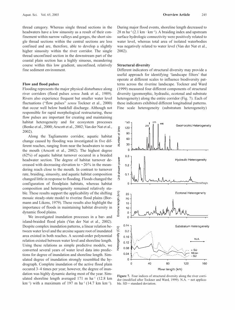
Longitudinal distribution of fishThe Tagliamento contains a rich fish fauna. Thirty fishspecies (including six freshwater species indigenous tothe Adriatic area and six non-native species), and twolamprey species are present (Stoch et al., 1992; Table 5).Species diversity peaked in the lower river section be-tween Casarsa and Latisana (Fig. 2) where cold-adaptedand warm-adapted species co-occurred, albeit in differentfloodplain water bodies. For example, cold alluvialgroundwater habitats were colonised by high densities of
salmonids (mainly the grayling, Thymallus thymallus),whereas isolated floodplain lakes provided habitats forcharacteristic lowland species such as Tinca tinca andEsox lucius. Intact river-floodplain systems exhibit highwithin-reach thermal heterogeneity (Ward, 1985; Stan-ford et al., 1996; Arscott et al., 2001) which was largelyignored in the development of classic fish zonation con-cepts. Downstream of Latisana, in the brackish river sec-tion, sturgeons (A. naccarii and A. sturio) were some-times found (Stoch et al., 1992).
Riverine Islands
One of the most distinct features of the Tagliamento is thepresence of a large number of bars and vegetated islands(Figs. 8, 9). Riverine islands can be defined as “land-forms, elevated above and surrounded by stream-channelbranches or waterways that persist sufficiently long to es-tablish permanent vegetation” (Osterkamp, 1998) or, in amore strict sense, as “discrete areas of woody vegetationwithin the active alluvial plain” (Ward et al., 2000; Gur-nell et al., 2001). Processes by which islands form in-clude avulsion, channel incision, channel migration, ordeposition of bed sediments on a vegetated surface or be-hind a channel obstruction. Island formation is a directresult of high-energy processes that redistribute largeamounts of sediments; islands are classified as “high-en-ergy landforms” (sensu Osterkamp, 1998).
Island formationIt has been proposed that the combination of a naturalflood regime, a sufficient source of sediment and largewoody debris (LDW), and an unconstrained channel pro-vides optimal conditions for the formation of islands (Ed-wards et al., 1999; Kollmann et al., 1999; Ward et al.,2000; Gurnell et al., 2001; Gurnell and Petts, 2002).LWD, mainly uprooted trees, transported by floods mayinitiate the process that transforms a gravel bar into a veg-etated island (Abbe and Montgomery, 1996). Manyspecies of floodplain trees resprout vigorously if thetrunk and branches come to rest where environmentalconditions are suitable; most successful in this respect arePopulus nigra, Salix elaeagnos, S. alba, S. purpurea andS. daphoides, whereas Alnus incana is apparently less ca-pable of regeneration, and Alnus glutinosa, Fraxinus ex-celsior and Pinus sylvestris lack this ability. LWD alsocontributes to island development by accumulating sedi-ments within which seeds germinate.
Edwards et al. (1999) and Kollmann et al. (1999) de-scribe in detail successional processes on gravel bars,from stranded trees to pioneer islands and finally to es-tablished islands. Island vegetation in island-braidedreaches of the Tagliamento is highly dynamic, eliminated
Aquat. Sci. Vol. 65, 2003 Overview Article 247
by occasional massive erosion, and re-established byrapid regeneration by willows and poplars. Localizedsedimentation and subsequent island formation are un-doubtedly facilitated once woody vegetation becomes es-tablished. Island development and succession of the veg-etation are tightly connected (Edwards et al., 1999).Early-successional stages are linked in a cyclic processby the flood regime, by positive interactions betweengrowth of woody species and sedimentation, and increas-ing stability of more established islands. Under these con-ditions island development in streams seems to be aunique form of cyclic succession (sensu Glenn-Lewinand van der Maarel, 1992) that does not fit within thestandard concepts of succession and zonation withinAlpine flood plains (Moor, 1958; Heller, 1969; Ellen-berg, 1988). Clearly, in the active zone of an Alpine flood-plain river, succession never reaches the stage of maturesoftwood or hardwood forests that are typical for less fre-quently disturbed or higher elevation sites on flood plains(Hupp and Osterkamp, 1985; Schnitzler, 1997).
248 K. Tockner et al. A model ecosystem
Table 5. Distribution of fish species along the Tagliamento (data: Stoch et al., 1992). R: very rare species. E: endemic species to the Adri-atic area. *: non-native species.
Species Upper Middle Lower CoastalTagliamento Tagliamento Tagliamento Tagliamento
E Lampetra zanandreai X XPetramyzon marinus X X
R Acipenser sturio XE,R Acipenser naccarii X
Anguilla anguilla X X XAlosa fallax X XSalmo trutta trutta X X X
E Salmo trutta marmoratus X X X* Oncorhynchus mykiss X X* Salvelinus fontinalis X
Thymallus thymallus X XEsox lucius X X
E Rutilus aula X XLeusciscus cephalus X X
R Leusiscus souffia XPhoxinus phoxinus X X X XTinca tinca X XScardinius erythrophthalmus X XAlburnus alburnus alborella X XChondrostoma toxostoma X X
R Gobio gobio XBarbus barbus plebejus X X X
* Cyprinus carpio X* Carassius carassius X* Carassius auratus X
Cobitis taenia X XGasterosteus aculeatus X X XCottus gobio X X X
* Lepomis gibbosus X X XPerca fluviatilis X
E Padogobius martensi XE Orsinigobius punctatissimus X
Number of Species 6 23 23 10
The dynamic nature of a section of the TagliamentoRiver corridor was investigated by analysing aerial pho-tographs of a 125 ha active floodplain zone for three dif-ferent dates (1984, 1986, 1991). Dramatic changes inlandscape configuration were documented, although therelative proportion of pioneer islands, established islandsand river channels remained relatively constant (Vieli,1998; Kollmann et al., 1999). Other studies have shownthat the total area of woody vegetation in a braided rivercan change considerably over time, e.g. Bayard andSchweingruber (1991) for the Maggia, Switzerland(1933–1987) or Marston et al. (1995) for the Ain RiverFrance (1945–1991). Photographs from the Tagliamentoin 1917 and 1945 show a much lower cover of woody veg-etation than in recent years, perhaps reflecting a long-term trend caused by anthropogenic impacts (decrease ofthe water table, increased nutrient load, or changes in theinput of LWD) (also see Astori, 1993).

Aquat. Sci. Vol. 65, 2003 Overview Article 249
Figure 8. Oblique aerial view of the island-braided section upstream of Pinzano illustrating the high habitat diversity. Note the clear back-water in contrast to the turbid floodwaters of the main channel (Photo: K. Tockner; 1997).
Island distributionThere probably are 652 established river islands (> 70 m2)along the river corridor of the Tagliamento (Ward et al.,2000). The maximum number of islands per river-km was25 (Fig. 9A) with up to 400 islands per km2 of activeflood plain. The combined surface area of all islands(10.6 km2) corresponded to 17% of the total area of theactive corridor. These islands contributed considerably tothe total ecotone length (riparian forest boundary zone);about 50% of the total ecotone length (668 km) can be at-tributed to the presence of islands (Ward et al., 2000).Surface area of individual islands ranged from 0.007 hato 41.7 ha. Most islands were small in headwater sectionscompared to islands in the middle and the lower sections.In all sections, however, size heterogeneity of islands washigh (Fig. 9B). The diversity and complexity of islandpatterns suggest that different processes are involved intheir formation. A typology of islands based on formationprocess, size, form and structure is clearly needed (Gur-nell et al., 2001).
In addition to the 652 established islands, countlesspioneer islands (Phase I and Phase II islands, sensu Edwards et al., 1999) were observed along the river cor-ridor. Gurnell et al. (2001) stress that pioneer islands, de-spite their limited areal extend, are important in retaininglarge woody debris (LWD). They calculated an averagestorage of 293 to 1664 tonnes ha–1 LWD on pioneer is-lands compared to 1–6 tonnes ha–1 on exposed bare gravelsurfaces.
Figure 9. A: Islands per river-km along the river corridor (basedon the analysis of information derived from air-photographs and1:10000 scale maps; 1984–1985). B: Size distribution of islands indifferent sections along the corridor (average ± SD).

Ecological importance of islandsMost of what we know about bars and islands relatesmainly to formation dynamics form the perspectives ofhydraulics and fluvial geomorphologists (Fetherston etal., 1995; Abbe and Montgomery, 1996; Osterkamp,1998). However, the ecological role of islands has beenlargely ignored by stream ecologists (Ward et al., 1999c)because so few remain, even in the least impacted riversystems. Islands are one of the first features to be elimi-nated from river systems by human alterations for floodcontrol and navigation.
The presence and dynamics of vegetated islandslikely have an important influence on biodiversity by pro-viding a variety of aquatic and terrestrial habitats (Fig.10). Islands and bars are frequently associated with back-waters, which together with eddies and floodplain lakesmay provide important refuge areas for invertebrates andfish. For example, a high proportion of juvenile fish oc-cur in floodplain ponds and backwaters (K. Tockner, pers.observation), in particular if these habitats contain LWD.In addition, ponds and backwaters produce large amountsof algal biomass that may drive metabolism in high orderreaches (Thorp and Delong, 1994). “Dead zones” likebackwaters are not only important centres for “instreamproductivity” but also increase the overall retentivenessof rivers.
Riverine dynamics also create a diversity of flood-plain habitats for terrestrial invertebrates. The relativeproportion of four major terrestrial groups, Formicidae,Arachnidae, Carabidae and Staphylinidae changedmarkedly across a riparian-floodplain transect (Fig.10A). Carabidae and Staphylinidae beetles are able torapidly colonise unstable habitats such as gravel barsand shorelines due to their high dispersal capacity. Inthe more stable riparian habitats, ants and spiders pre-dominate. Based on the community structure of thecarabid fauna, Rust (1998) identified three major habi-tat groups: (1) riparian forest and established islands (2)LWD and pioneer islands, and (3) bare gravel bars andshoreline habitats. In a random sample of 100 individu-als, the expected number of carabid species was 27 forgroup 1 habitats, 24 for group 2, and 13 for group 3 (Fig.10B). Established and pioneer islands were charac-terised by a high proportion of rare species; however,highest abundance was found along shorelines (up to150 Ind. m–2). This undoubtedly is attributed to concen-tration of prey species, i.e., emerging insects and drift-ing invertebrates, at shoreline locations (Hering andPlachter, 1997).
Thirteen Amphibian taxa were identified along theTagliamento with Rana latastei and Bufo bufo beingpredominate (Klaus et al., 2001). In the main studyreach, a 2 km2 dynamic island-braided flood plain in themiddle section of the river, 130 waterbodies were delin-eated that were situated either in the active flood plain
(82 sites) or in the adjacent riparian forest (48 sites). Re-sults demonstrated that the active flood plain increasedappreciably the available habitat for amphibians, despitefrequent disturbances by floods or droughts. Amphibianrichness within a given habitat was significantly relatedto distance from islands, fish density and water temper-ature. Vegetated islands and large woody debris playedpivotal roles, directly and indirectly, in maintaining both habitat and amphibian diversity in this gravel-bedriver.
250 K. Tockner et al. A model ecosystem
Figure 10. A. Relative proportion (%) of four terrestrial inverte-brate taxa across a floodplain transect (upstream of Pinzano, Fig.11). B: Carabid beetles: Species/abundance relationship (rarefac-tion curves) in three distinct habitat types and in all habitats typescombined (see text) (Rust, 1998).
A
B

Perspectives
Conservation and restoration goals should be compatiblewith fundamental ecological theory (Stanford et al.,1996; Tockner et al., 1998; Ward et al., 2001; Tockner andStanford, 2002). The fundamental concepts that underpincurrent scientific knowledge of riverine ecosystems havebeen formulated over the past two decades. In their initialformulations, both the River Continuum Concept (Van-note et al., 1980) and the Serial Discontinuity Concept(Ward and Stanford, 1983) ignored floodplain dynamics,although subsequent modifications rectified this to someextent (Sedell et al., 1989; Ward and Stanford, 1995). TheFlood Pulse Concept (Junk et al., 1989; Tockner et al.,2001), although focusing on floodplain dynamics, isbased largely on tropical rivers. What is lacking is a rig-orous conceptual model for dynamic floodplain rivers ofthe temperate zone. The limited empirical knowledge ofdynamic processes operating in natural systems meansthat we lack sound »benchmarks« not only for assessinghuman impacts, but also for addressing restoration andconservation strategies.
The Tagliamento River in Italy offers the rare oppor-tunity to investigate natural processes at a scale that canbe studied nowhere else in Europe. This remarkable rivercorridor exemplifies the ecological processes and pat-terns that must have characterised Alpine gravel bedrivers. The Fiume Tagliamento is clearly a river ecosys-tem of European importance, since it constitutes a uniqueresource as a model reference catchment. Therefore, thepresent authors have initiated a major research pro-gramme which integrates hydrology, geomorphology andecology of the Tagliamento River corridor (Edwards etal., 1999; Gurnell et al., 2000a, b, 2001; Kollmann et al.,1999; Tockner and Ward, 1999; Arscott et al., 2000, 2001;Ward et al., 1999b, 2000). The outcome of the researchprogramme is intended not only to advance knowledge ofnatural rivers, but will also provide the scientific basis formore sustainable management of functional processes.We wish to establish a hierarchical landscape perspectivefor riparian ecosystems as an essential basis for develop-ing catchment-wide restoration and conservation strate-gies that include (i) preservation of unconstrained ripar-ian corridors, (ii) maintenance of flow variability, and(iii) preservation of the capacity of the system to undergochange. It is already clear that the factors controllingecosystem processes or biodiversity patterns operateacross a range of spatio-temporal scales that transcendtraditional river management programmes.
Specifically, three major aspects are deemed essentialfor understanding Alpine braided gravel bed rivers: (i)viewing river-floodplain ecosystems as hierarchicalecosystems containing nested spatial and temporalscales, (ii) linking terrestrial and aquatic ecosystems, (iii)investigating the actual processes of island dynamics.
River-floodplain ecosystems are expanding, contracting,and often fragmented ecosystems (Stanley et al., 1997;Ward et al., 1999c; Malard et al., 1999; Tockner et al.,2000). These changes in size are thought to control habi-tat availability and environmental conditions as well asfaunal/floral composition and ecological processes. Theexpansion and contraction cycle is a fundamental prop-erty of all floodplain ecosystems, although, it has beengenerally neglected by stream ecologists. We propose thatthe Flood Pulse Concept could be adapted to accommo-date the characteristics of river-floodplain systems out-side tropical climates, particularly those in the temperatezone. Furthermore, water level fluctuations well below`bankfull` may dominate ecosystem processes and thedistribution of biotic communities (‘flow pulse’vs. ‘floodpulse’; Puckridge et al., 1998; Tockner et al., 2000). Thepresent authors are particularly interested in the dynam-ics of vegetated islands on the active flood plain and theirrole in maintaining biodiversity (Ward et al., 1999b). Thefact that anthropogenic impacts have eliminated islandsfrom many rivers makes an understanding of their roleeven more crucial. Islands not only provide informationof recent geomorphic history and processes but island dy-namics may also serve as an ecosystem-level indicator ofthe condition of riverine corridors (Ward et al., 2000,2001).
However, the Tagliamento is a highly endangeredecosystem. The regional government is planning 14 km2
large flood retention basins in the most natural section.About 30 mill m3 of material, mainly gravel, will be ex-cavated. These retention basins should protect urban ar-eas along the channelized downstream section of the riveragainst floods of up to 100-yr events. In addition, a high-way following the main stem of the river and new indus-trial areas will severely impact the corridor. The futureconservation of the Tagliamento will be a benchmark forthe European Water Framework Directive (WFD). If weare not able to protect the last semi-natural rivers, the dis-cussions on restoration projects remain useless. There-fore, scientists are working closely together with conser-vation agencies in order to develop a sustainable man-agement plan for the Tagliamento River, which is calledthe “King of the Alpine Rivers”.
Acknowledgements
We thank Achim Paetzold, Luana Bottinelli, PeterBurgherr, Urs Holliger, Richard Illi, Ute Karaus, andChristian Rust (EAWAG/Dübendorf), Fabio Stoch (Tri-este), Antonella Astori (Tolmezzo), Roberto Furlan andAlberto Deano (Trieste), Francesco Baruffi and NicolaSurian (Venice), Bruna Gumiero (Bologna), Nicoletta To-niutti (WWF), Andrea Marin (Udine), and Mario Vieli(Geobotanical Institute, ETH) for their valuable contribu-
Aquat. Sci. Vol. 65, 2003 Overview Article 251
tions. Supported in part by a research grant from theETH-Zürich and by Grant GR9/03249 from the UKNERC to AMG and GEP.
References
Abbe, T. B. and D. R. Montgomery, 1996. Large woody debris jams,channel hydraulics and habitat formation in large rivers. Reg.Riv. 12: 201–221.
Arscott, D. B., K. Tockner and J. V. Ward, 2000. Aquatic habitat di-versity along the corridor of an Alpine floodplain river (FiumeTagliamento, Italy). Archiv Hydrobiol. 149: 679–704.
Arscott, D. B., K. Tockner and J. V. Ward, 2001. Thermal hetero-geneity along a braided floodplain river (Tagliamento River,northeastern Italy). Can. J. Fish. Aquat. Sci. 58: 2359–2373.
Arscott, D. B., K. Tockner, D. Van der Nat and J. V. Ward, 2002.Aquatic habitat dynamics along a braided Alpine river ecosys-tem (Tagliamento River, Northeast Italy). Ecosystems 5:802–814.
Astori, A., 1993. Morfologie alluvionali e dinamica fluviale di unfiume-torrente Alpino: il F.Tagliamento a Tolmezzo (Carnia),Master Thesis, Univ. of Padova.
Baumgartner, A., E. Reichel and G. Weber, 1983. Der Wasser-haushalt der Alpen, R. Oldenburg, Munich.
Bayard, M. and F. H. Schweingruber, 1991. Ein Baumgrenzstan-dort: Das Wildwasserbett der Maggia im Tessin, Schweiz. Einedendroökologische Studie. Bot. Helv. 101: 9–28.
Benke, A. C., I. Chaubey, M. G. Ward and E. L. Dunn, 2000. Floodpulse dynamics of an unregulated river floodplain in the south-eastern U.S. coastal plain. Ecology 81: 2730–2741.
Bill, H.-Ch., P. Poschlod, M. Reich and H. Plachter, 1999. Experi-ments and observations on seed dispersal by running water inan Alpine floodplain. Bull. Geobot. Inst. ETH 65: 13–28.
Billi, P., R. D. Hey, C. R. Thorne and P. Tacconi, 1992. Dynamics ofgravel-bed rivers, Wiley, Chichester.
Bormann, F. H. and G. E. Likens, 1979. Pattern and process in aforested ecosystem, Springer, New York.
Cattaneo, A., G. Salmoiraghi and S. Gazzera, 1995. The rivers ofItaly. In: C. E. Cushing, K. W. Cummins and G. W. Minshall(eds.), River and stream ecosystems. Elsevier, Amsterdam, pp.479–505.
CIPRA, 1998. Alpenreport, Verlag Haupt, Bern.Dynesius. M. and C. Nilsson, 1994. Fragmentation and flow regu-
lation in the northern third of the world. Science 266: 753–762.Edwards, P. J., J. Kollmann, A. M. Gurnell, G. E. Petts, K. Tockner
and J. V. Ward, 1999. A conceptual model of vegetation dynam-ics on gravel bars of a large Alpine river. Wetlands Ecol.Manag. 7: 141–153.
Electroconsult, 1979. Tagliamento: Dati idrologici. Rapporto pre-liminare, Regione Autonoma Friuli-Venezia Giulia, Trieste.
Ellenberg, H., 1988. Vegetation ecology of central Europe, Cam-bridge University Press, Cambridge.
Fetherston, K. L., R. J. Naiman and R. E. Bilby, 1995. Large woodydebris, physical process, and riparian forest development inmontane river networks of the Pacific Northwest. Geomor-phology 13: 133–144.
Gentilli, J., 1971. Il Friuli, I Climi. Udine.Gerken, B., K. Dörfer, M. Buschmann, S. Kamps-Schwob, J.
Berthelmann and D. Gertenbach, 1991. Composition and dis-tribution of carabid communities along rivers and ponds in theregion of the Upper Weser (NW/ND/FRG) with respect to pro-tection and management of a floodplain ecosystem. Reg. Riv. 6:313–320
Glenn-Lewin, D. C. and E. van der Maarel, 1992. Patterns andprocesses of vegetation dynamics. In: D. C. Glenn-Lewin, R. K.Peet and T. T. Veblen (eds.), Plant succession: theory and pre-diction, Chapman and Hall, London, pp. 11–59.
Gurnell, A. M. and G. E. Petts, 2002. Island-dominated landscapesof large floodplain rivers, a European perspective. Freshwat.Biol. 47: 581–600.
Gurnell, A. M., G. E. Petts, D. M. Hannah, B. P. G. Smith, P. J. Ed-wards, J. Kollmann, J. V. Ward and K. Tockner, 2000a. Woodstorage within the active zone of a large European gravel-bedriver. Geomorphology 34: 55–72.
Gurnell, A. M., G. M. Petts, N. Harris, J. V. Ward, K. Tockner, P. J.Edwards and J. Kollmann, 2000b. Large wood retention in riverchannels: The case of the Fiume Tagliamento, Italy. Earth Surf.Proc. Land. 25: 255–275.
Gurnell, A. M., G. E. Petts, D. M. Hannah, B. P. G. Smith, P. J. Ed-wards, J. Kollmann, J. V. Ward and K. Tockner, 2001. Island for-mation along the gravel-bed Fiume Tagliamento, Italy. EarthSurf. Proc. Land. 26: 31–62.
Heidt, E., V. Framenau, D. Hering and R. Manderbach, 1998. DieSpinnen- und Laufkäferfauna auf ufernahen Schotterbänkenvon Rhone, Ain (Frankreich) und Tagliamento (Italien) (Arach-nida: Araneae; Coleoptera: Carabidae). Entomol. Z. 108:142–153.
Heller, H., 1969. Lebensbedingungen und Abfolge der Flussvegeta-tion in der Schweiz. Mit. Schweiz. Anstalt forstl. Versuchswe-sen 45: 1–124.
Hering, D. and H. Plachter, 1997. Riparian ground beetles(Coleoptera, Carabidae) preying on aquatic invertebrates: afeeding strategy in alpine floodplains. Oecologia 111:261–270.
Hormann, K., 1964. Torrenten in Friaul und die Längsprofilent-wicklung auf Schottern, Münchner geographische Hefte, Heft29, München.
Hupp, C. R. and W. R. Osterkamp, 1985. Bottomland vegetationdistribution along passage creek, Virginia, in relation to fluviallandforms. Ecology 66: 670–681.
Junk W. J., P. B. Bayley and R. E. Sparks, 1989. The flood pulse con-cept in river-floodplain systems. Can. Spec. Publ. Fish. Aquat.Sci. 106: 110–127.
Klaus, I., C. Baumgartner and K. Tockner, 2001. Die Wildflus-slandschaft des Tagliamento (Italien, Friaul) als Lebensraumfür eine artenreiche Amphibiengesellschaft. Z. f. Feldherpet. 8:21–30.
Kollmann, J., M. Vieli, P. J. Edwards, K. Tockner and J. V. Ward,1999. Interactions between vegetation development and islandformation in the Alpine river Tagliamento. Appl. Veg. Sci. 2:25–36.
Lippert, W., N. Müller, S. Rossel, T. Schauer and G. Vetter, 1995.Der Tagliamento – Flussmorpholgie und Auenvegetation dergrössten Wildflusslandschaft der Alpen. J. Ver. z. Sch. Bergw.60: 11–70.
Lohmeyer, W. and H. Sukopp, 1992. Agriophyten in der VegetationMitteleuropas. Schrift. Vegetationskunde 25: 1–185.
Malard, F., K. Tockner and J. V. Ward, 1999. Shifting dominance ofsubcatchment water sources and flow paths in a glacial flood-plain, Val Roseg, Switzerland. Arct. Ant. Alp. Res. 31:135–150.
Malanson, G. P., 1993. Riparian landscapes, Cambridge UniversityPress, Cambridge.
Maione, U. and G. Machne, 1982. Studio sulla formazione dellepiene del Fiume Tagliamento, ECOCONSULT, Milano.
Marston, R. A., J. Girel, G. Pautou, H. Piégay, J.-P. Bravard and C.Arneson, 1995, Channel metamorphosis, floodplain distur-bance, and vegetation development: Ain River, France. Geo-morphology 13: 121–131.
Martinet, F. and M. Dubost, 1992. Die letzten naturnahen Alpen-flüsse-Versuch eines Inventars, CIPRA, Vaduz, FL.
Martinis, B., 1993. Storia geologica del Friul, La Nuova Base Ed.,Udine.
Meybeck, M., 1996. River water quality: Global ranges, time andspace variabilities, proposal for some redefinitions. Verh. Inter-nat. Verein. Limnol. 26: 81–96.
252 K. Tockner et al. A model ecosystem

Moor, M., 1958. Die Pflanzengesellschaften schweizerischer Fluss-auen. Mitt. Schweiz. Anst. forstl. Versuchsw. 34: 221–360.
Mosetti, F., 1983. Sinisti sull`idrologica del Friuli-Venzia Giulia,Quaderni dell’Ente Tutela Pesce del Friuli-Venzia Giulia, Riv-ista di Limnologia, No 6.
Muhar, S., M. Kainz, M. Kaufmann and M. Schwarz, 1998. Erhe-bung und Bilanzierung flusstypspezifisch erhaltener Fliess-gewässerabschnitte in Österreich. Öst. Wasser Abfallwirtschaft5/6: 119–127.
Müller, N., 1995. River dynamics and floodplain vegetation andtheir alterations due to human impact. Arch. Hydrobiol. Suppl.101: 477–512.
Osterkamp, W. R., 1998. Processes of fluvial island formation, withexamples from Plum Creek, Colorado and Snake River, Idaho.Wetlands 17: 530–545.
Petts, G. E., H. Möller and A. L. Roux, 1989. Historical change oflarge alluvial rivers: Western Europe, Wiley, Chichester.
Plachter, H., 1998. Die Auen alpiner Wildflüsse als Modellestörungsgeprägter ökologischer Systeme. Schf.-R.f. Land-schaftspfl. u. Naturschutz 56: 21–66
Poldini, L., 1991. Atlante corologico delle piante vascolari nelFriuli-Venzia Giulia, Università degli Studi di Trieste, Trieste.
Provincia di Udine, 1997. Mappaggio biologico di qualità dei corsid’acqua della provincia di Uine, Udine, 104pp.
Puckridge, J. T., F. Sheldon, K. F. Walker and A. J. Boulton, 1998.Flow variability and the ecology of large rivers. Mar. Freshw.Res. 49: 55–72.
Regione Autonoma Friuli-Venezia Giulia, 1982. Mappatura auto-matica delle risorse idriche regionali, Trieste.
Reich, M., 1994. Kies- und schotterreiche Wildflusslandschaften –primäre Lebensräume des Flussregenpfeifers (Charadrius du-bius). Vogel u. Umwelt 8: 43–52.
Rust, C., 1998. Die ökologische Bedeutung von Inseln und Schot-terbänken im Tagliamento (Friaul, Italien) am Beispiel derLaufkäferzönose (Carabidae, Insecta), Diplomarbeit, ETH-Zürich.
Schnitzler, A., 1997. River dynamics as a forest process: Interactionbetween fluvial systems and alluvial forests in large Europeanriver plains. The Bot. Rev. 63: 40–64.
Sedell, J. R., J. E. Richey and F. J. Swanson, 1989. The river contin-uum concept: a basis for the expected ecosystem behavior ofvery large rivers? Can. Spec. Publ. Fish. Aquat. Sci. 106:49–55.
Stanley, E. H., S. G. Fisher and N. B. Grimm, 1997. Ecosystem expansion and contraction in streams. BioScience 47: 427–435.
Stanford, J. A., J. V. Ward, W. J. Liss, C. A. Frissell, R. N. Williams,J. A. Lichatowitch, and C. C. Coutant, 1996. A general protocolfor restoration of regulated rivers. Reg. Riv. 12: 391–413.
Stefanini, S., 1982. Le sistemazioni idraulico-forestali nella Carnia(bacino montana del Fiume Tagliamento), Regione AutonomaFriuli-Venezia Giulia, Trieste.
Steinicke, E., 1991. Friaul. Bevölkerung und Ethnizität, Inns-brucker Geogr. Studien 19. Inst. für Geographie, Univ. Inns-bruck.
Stoch, F., S. Paradisi and M. B. Dancevich, 1992. Carta Ittica delFriuli-Venezia Giulia, ETP, Udine.
Thorp, I. H. and M. D. Delong, 1994. The riverine productivitymodel: an heuristic view of carbon sources and organic pro-cessing in large river ecosystems. Oikos 70: 305–308.
Tockner, K., F. Schiemer and J. V. Ward, 1998. Conservation byrestoration: the management concept for a river-floodplain sys-tem on the Danube River in Austria. Aquat. Conserv. 8: 71–86.
Tockner, K. and J. V. Ward, 1999. Biodiversity along riparian corri-dors. Arch. Hydrobiol. Suppl. 115: 293–310.
Tockner, K., F. Malard and J. V. Ward, 2000. An extension of theFlood Pulse Concept. Hydrol. Proc. 14: 2861–2883.
Tockner, K. and J. A. Stanford, 2002. Riverine flood plains: presentstate and future trends. Envir. Conserv. 29: 308–330.
Tutin, T. G., V. H. Heywood, N. A. Burges, D. H. Valentine, S. M.Walters and D. A. Webb, 1964–80. Flora Europaea, Vol. 1–5,Cambridge University Press, Cambridge.
Van der Nat, D., A.P. Schmid, K. Tockner, P. J. Edwards and J. V.Ward, 2002. Inundation dynamics in braided floodplains:Tagliamento River, northeast Italy. Ecosystems 5: 636–647.
Vannote, R. L., G. W. Minshall, K. W. Cummins, J. R. Sedell and C.E. Cushing, 1980. The river continuum concept. Can. J. Fish.Aquat. Sci. 37: 130–137.
Vieli, M., 1998. Luftbild- und GIS-gestützte Vegetationsunter-suchungen am Tagliamento, Diplomarbeit, Univ. Zürich undETH-Zürich.
Ward, J. V., 1985. Thermal characteristics of running waters. Hy-drobiol. 125: 31–46.
Ward, J. V., 1998. Riverine landscapes: biodiversity patterns, distur-bance regimes, and aquatic conservation. Biol. Cons. 83:269–278.
Ward, J. V. and J. A. Stanford, 1983. The serial discontinuity conceptof lotic ecosystems. In: T. D. Fontaine and S. M. Bartell (eds.),Dynamics of lotic ecosystems, Ann Arbor Science, Ann Arbor,MI, pp. 29–42.
Ward, J. V. and J. A. Stanford, 1995. The serial discontinuity con-cept: extending the model to floodplain rivers. Reg. Riv. 10:159–168.
Ward, J. V. and K. Tockner, 2001. Biodiversity: towards a unifyingtheme for river ecology. Freshwat. Biol. 46: 807–819.
Ward, J. V., K. Tockner and F. Schiemer, 1999a. Biodiversity offlooplain river ecosystems: ecotones and connectivity. Reg.Riv. 15: 125–139.
Ward, J. V., K. Tockner, P. J. Edwards, J. Kollmann, G. Bretschko, A.M. Gurnell, G. E. Petts B. Rossaro, 1999b. A reference systemfor the Alps: the ‘Fiume Tagliamento’. Reg. Riv. 15: 63–75.
Ward, J. V., F. Malard, K. Tockner and U. Uehlinger, 1999c. Influ-ence of ground water on surface water conditions in a glacialflood plain of the Swiss Alps. Hydrol. Proc. 13: 277–293.
Ward, J. V., K. Tockner, P. J. Edwards, J. Kollmann, G. Bretschko, A.M. Gurnell, G. E. Petts and B. Rossaro, 2000. Potential role ofisland dynamics in river ecosystems. Verh. Int. Verein. Limnol.27: 2582–2585.
Ward, J. V., K. Tockner, U. Uehlinger and F. Malard, 2001. Under-standing natural patterns and processes in river corridors as thebasis for effective river restoration. Reg. Riv. 17: 311–323.
Wintersberger, H., 1996. Spatial resource utilisation and species as-semblages of larval and juvenile fish. Arch. Hydrobiol. Suppl.115: 29–44.
Aquat. Sci. Vol. 65, 2003 Overview Article 253