
The Surficial Geology of the Spring Hill Quadrangle with map · The surficial geology of the Spring...
36
Open Map
Transcript of The Surficial Geology of the Spring Hill Quadrangle with map · The surficial geology of the Spring...

STATE GEOLOGICAL AND NATURAL HISTORY SURVEY
OF CONNECTICUT
A DIVISION OF THE DEPARTMENT OF AGRICULTURE
AND NATURAL RESOURCES
The Surficial Geology
of the
Spring Hill .Quadrangle WITH MAP
PERRY H. RAHN
South Dakota School of Mines and Technology
1971
QUADRANGLE REPORT NO. 26
----------------------- . ------

STATE GEOLOGICAL AND NATURAL HISTORY SURVEY
OF CONNECTICUT
A DIVISION OF THE DEPARTMENT OF AGRICULTURE AND NATURAL RESOURCES
HoNORABLE THOMAS J. MESKILL, Governor of Connecticut
JoHN T. MACDONALD, Commissionr?r of the Department of Agriculture and N aturcl Resources
COMMISSIONERS
HoN. THOMAS J. MESKILL, Governor of Connecticut
DR. J. WENDELL BuRGER, Department of Biology, Trinity College
DR. RICHARD H. GOODWIN, Department of Botany, Connecticut College
DR. JoE WEBB PEOPLES, Department of Geology, Wesleyan University
DR. JoHN RODGERS, Department of Geology, Yale University
DR. JAMES A. SLATER, Department of Zoology and Entomology, University of Connecticut
DIRECTOR
JoE WEBB PEOPLES, Ph.D. Wesleyan University, Middletown, Connecticut
EDITOR
Lou WILLIAMS PAGE, Ph.D.
DISTRIBUTION AND EXCHANGE AGENT
WALTER BRAHM, State Librarian
State Library, Hartford
ii

TABLE OF CONTENTS
Page
Abstract -------------------------------------------------------------------------------------------------------------------------- 1
Introduction ------------------------------------------------------------------------------------------------------------ 1
Geography ------------------------------------------------------------------------------------------------------------------- 3
Bedrock geology ----------------------------------------------------------------------------------------------------------- 4
Drainage and topography ---------------------------------------------------------------------------------------- 5
Drainage ----------------------------------------------------------------------------------------------------------------- 5
Topography --------------------------------------------------------------------------------------------------------------- 6
Glacial geology ------------------------------------------------------------------------------------------------------------- 9
Glacial-erosion features -------------------------------------------------------------------------------------------- 9
Bedrock features --------------------------------------------------------------------------------------------------- 9
Drumlins -------------------------------------------------------------------------------------------------------------- 12
Glacial sediments ------------------------------------------------------------------------------------------------------ 13
General statement ----------------------------------------------------------------------------------------------- 13
Till ---------------------------------------------------------------------------------------------------------------------- 14
Stratified drift ----------------------------------------------------------------------------------------------------- 17
Postglacial sediments ------------------------------------------------------------------------------------------------ 22
Terrace alluvium ------------------------------------------------------------------------------------------------------ 22
Alluvium -------------------------------------------------------------------------------------------------------------------- 24
Swamp muck ----------------------------------------------------------------------------------------------------------- 25
Colluvium ----------------------------------------------------------------------------------------------------------------- 25
Artificial fill --------------------------------------------------------------------------------------------------------------- 26
Glacial and postglacial history ------------------------------------------------------------------------------ 26
------------------------------------------------------------------------------------- 27 Economic Geology
Sand and gravel ------------------------------------------------------------------------------------------ 27
Swamp deposits ---------------------------------------------------------------------------------------------------------- 28
Ground water ------------------------------------------------------------------------------------------------------------ 28
References -------------------------------------------------------------------------------------------------------------------- 30
iii

ILLUSTRATIONS
Page Plate 1. Map of the surficial geology of the Spring Hill
quadrangle --------------------- ------------------------------------------ ----------------- (in pocket)
Figure 1. Index map of Connecticu~ showing location of the Spring Hill
2.
3.
quadrangle and of other published quadrangle maps ------------------------- 2
The three natural regions of Connecticut --------------------- ------------------------ 3
Cross section of the Fenton River valley __ ----------------- -------------------- 5
4. Differential weathering of schist and pegmatite _ 7
8
9
5.
6.
7.
8.
Development of cuesta- and stoss-and-lee topography ____________________ _
Cuesta topography on gently dipping bedrock
Glacially polished bedrock _ _____________ ---------------------------------------- 10
Pothole south of Gurleyville ------------------------------ 11
9. Streamline hill on University of Connecticut campus -------------------------- 12
10.
11.
Till over bedrock at Mansfield Center
Typical till surface at Wormwood Hill
13
--------------- ------ ------------------------ 15
12. Kame-terrace deposit in Fenton River valley ---------------------------------------- 18
13. Cross sections of typical eskers - --- ------------------------------------------ 19
14. Diana's Pool on the Natchaug River - --------------------------------- ----------------- 21
15. Mansfield Center ice-contact plain ___ _
16. Stereo aerial photographs of Mansfield Center
22
23
17. Stratified drift and fluvial gravel exposed in the Mansfield dump ________ 24
18. Contact of till and stratified drift near Chaffeeville ---------------------------- 26
TABLE
Table 1. Particle-size distribution of four types of surficial deposits in the Spring Hill quadrangle ------------------------------------------------------------------------------ 14
iv

The Surficial Geology of the
Spring Hill Quadrangle by
Perry H. Rahn
ABSTRACT
The major topographic elements in the Spring Hill quadrangle were formed by preglacial erosion of dipping metamorphic bedrock into alternating cuestas and valleys. Three major rivers, all south-flowing, the Fenton, Mount Hope, and Natchaug, cut across the NE strike of these rocks in preglacial valleys.
The surface deposits and minor topographic features are primarily the work of the Wisconsin glaciation, which ended about 15,000 years ago. The regolith was eroded and areas of bedrock plucked and abraded. The resulting sediments were later deposited over most of the quadrangle as a thin blanket of till and stratified drift. The orientation of the long axes of drumlins indicates that the glacier moved SSE.
As the New England ice sheet melted and the front receded northward during deglaciation, its irregular margin was characterized by a zone of stagnant blocks of ice. In the Spring Hill area, this stagnant ice disintegrated into tongues confined to the major valleys. Adjacent to these ice masses, meltwater streams deposited sediment that collapsed later, during the final melting of the ice.
In postglacial time streams dissected the landscape, cutting ravines into the till-covered hillslopes. The major rivers cut downward, forming terraces and floodplains. Swamp muck filled the ponds that had formed in kettles and closed depressions in the till.
INTRODUCTION
The Spring Hill quadrangle (fig. 1) covers 56 sq. m1. m Connecticut between 41 ° 45' and 41 ° 52' 30" N latitude, and 72° 7' 30" and 72° 15' W longitude. It includes parts of the towns of Mansfield, Chaplin, Willington, and Ashford.
The surficial geology was mapped during 1966, 1967, and 1968. Geologic contacts were drawn directly on 1:20,000-scale aerial photographs, taken in March 1965; these contacts were later transferred to the 1: 24,000-scale base map (pl. 1). Data for that map were obtained by observations of natural and artificial exposures, and by aerial-photograph analysis of landforms. Subsurface data were collected from the flies of the State Highway Department, the State Water Resources Commission, the U.S. Geological Survey, and the University of Connecticut.
J. H. Hart5horn reviewed the geology in the field; in addition, he critically read the manuscript of this report, as did R. B. Colton, R. F. Flint, and W. E. Wilson.
1

M A s s 73° A c H u s E T T 72° s ~ A...~d lil! & ,;) <i-' ~v0 ,:; [()<i;:'Q "' "';y ;:, ~'
<o°' ,p -"'""'- -0~J1- ~~ """ ~<.;__ cf # o"-- ---l-
42° 0 0 42°
&- ff I"" o"° s~.t *" ~ ff ,# ~ ,&' _v(5_&> ,O ,a ,,,a :lJ ;y -$' "'0"'1' ~v 4' c.?
~ :::c
~I I I I ,__~ ,.,_
~ ... , .If i;_~v 0 ~<,;
"' 0::
0
~
IQ~ J .:f,
~v I
""' I "~ CJ)
I
,;) r "' ~"'I
3:1 ~ J> !).:>
"' ;,.'§' >~: <<:;,."" I<::::'@ I §'I I .-1-~'\ "''§§< };~: lF~rJO'l.l:,<->J'lbi'' <~ z s I ~ ~Qc' ~
c:f, ~
WI r:J ' <l:i « \
vO c;:,4.t' *"
I *'co <t ,,' ~~<-is@" • Quadrangle z " ii!-Q OQ;-OQ;-
~ / ~~ 'f''f' of This Report ,,,. \ v<,, ff
II ':._~~ -*o Published Published
4
lMAMiq OYSTERt Surficial Maps Bedrock Maps --141°
ONECK ,'BAY N E 13° W y 0 R K 72°
Fig. 1. Index map of Connecticut showing location of the Spring Hill quadrangle and of other published quadnngle map

The surficial geology of the Spring Hill quadrangle is treated briefly by Flint ( 1930). Foye ( 1949) discussed the general geology of eastern Connecticut with some reference to its physiographic development and glacial history. The U.S. Geological Survey conducted an investigation of the water resources of the Shetucket River basin; its reports ( M. P. Thomas and others, 1967; C. E. Thomas, Jr., and others, 1967) include a 1 :48,000-scale map of the basin, together with a description of the glacial deposits with particular reference to their properties as aquifers.
GEOGRAPHY
The Spring Hill quadrangle lies in the Upland Section of New England ( Fenneman, 1938, p. 345) and, more specifically, in the Eastern Highland physiographic region of Connecticut (fig. 2), an area of rolling hills underlain by metamorphic rocks of early Paleozoic age, whose upland surface slopes gently from Massachusetts toward Long Island Sound.
<' \ \
,--- -----------n -------r-------------, ,,_/ I I I I I I I I I
I I
WESTERN
! HIGHLAND I
I
I
\ ' ' /
,,,,,'
,' I :
f CENTRAL I D \ I I I I I I I I
I ' I ' I ' I I I I I I I I
I I
/LOM...ANq/ I I I I I I
{ / I ,-1 ,,.'
EASTERN
HIGHLAND I I
I I I
) \ I
Fig. 2. Map of Connecticut showing the boundaries of its three natural (physiographic) regions and the location of the Spring Hill quadrangle.
The quadrangle's maximum altitude, 747 ft above sea level, is in the northern part; its lowest altitude, 182 ft, is in the southern part. The upland surface, represented by hilltops, slopes southward at 20 ft per mi. Local relief, the difference between hills and adjoining valleys, is about 250 ft.
The Fenton, Mount Hope, and Natchaug rivers drain this quadrangle; they flow southward and converge in the Mansfield Hollow Reservoir, constructed in 1952 by the U.S. Army Corps of Engineers.
3

Most of the quadrangle is covered by a mixed hardwood forest. During the 18th and 19th centuries most of the forests that covered the area were cut down, the fields were cleared of boulders, and the land was farmed. Toward the end of the 19th century, the p::lpulation declined, and the fields were abandoned, to be reclaimed by the forests. Now only the numerous stone fences in the woods, some house foundations, and a few forgotten cemeteries remind one of the labors of these early Yankees. Such a reminder is the large stone wall along Brown's Road west of the Mansfield Center Congregational Church; it is one of the best built rock fences in New England.
About 25 percent of the quadrangle, largely lowlands underlain by sand and gravel, remains unforested. Easier to cultivate than the rocky uplands, this land is used primarily for grazing cattle and raising corn.
The quadrangle's population is increasing; many houses are being built, particularly near the University of Connecticut.
BEDROCK GEOLOGY
The bedrock geology of Connecticut was described by Percival ( 1842) and by Gregory and Robinson ( 1907). Rodgers, Gates, and Rosenfeld ( 1959) compiled a preliminary geologic map of the state with an explanatory text. Foye ( 1949) described the geology of eastern Connecticut; a geologic map of that part of the state was compiled by Goldsmith ( 1963); a portion of this map was revised by Dixon ( 1968). Aitken ( 1951) discussed part of the bedrock section of the Spring Hill quadrangle.
The bedrock geology of three adjacent quadrangles (fig. 1), Hampton, Scotland, and Willimantic, has been mapped by Dixon and Pessl ( 1966), Dixon and Shaw ( 1965), and Snyder ( 1964), respectively. J. M. Aitken is mapping the bedrock geology of the Spring Hill and the nearby South Coventry quadrangles. The petrology of the westcentral ninth of the Spring Hill quadrangle was studied by Hubbard ( 1966).
The bedrock consists of metamorphic rocks, mainly interlayered medium-grained quartzo-feldspathic gneiss and biotite schist, intruded by gneissic pegmatite sills and dikes, some as much as 40 ft thick. The most important formations in this quadrangle are the Brimfield Schist, Hebron Gneiss, Eastford Granitic Gneiss, and Willimantic Gneiss. Radioactive age determinations on selected granitic and pegmatitic rocks of eastern Connecticut indicate that these formations are Early Devonian or older (Zartman and others, 1965).
Bedrock outcrops are shown on plate 1 (in pocket). They are numerous but small and are commonly along ridge crests or in stream beds. These natural outcrops (locally called "ledge") have a rough texture due to differential weathering along foliation planes in postglacial times. The general trend of the foliation is NNE, and may represent the original bedding of the metasedimentary rocks. Generally, the foliation dips steeply-almost vertically-in the northwestern part of the quadrangle, near East Willington; however, in the southeastern part, near Chaplin,
4

it dips very gently. Small folds and structures within this general pattern are present, particularly in the West Willington area. The bedrock is commonly jointed perpendicular to the foliation.
DRAINAGE AND TOPOGRAPHY
Drainage
The three major rivers in the Spring Hill quadrangle, the Fenton, Mount Hope, and Natchaug, cut across the strike of the foliation of the metamorphic bedrock, as does Stonehouse Brook. Their valleys are deep, and probably preglacial. Their fairly straight courses indicate that they were formed by erosion along zones of weakness, such as major faults or joints. The rivers are subsequent streams: they have shifted to weaker, more erodible rocks. Locally, near Atwoodville ( 347,-000 N, 756,500 E), 1 South Chaplin (345,000 N, 768,700 E), and Mansfield Hollow ( 336,500 N, 754,600 E), the rivers flow across the bedrock as falls and rapids. South of Daleville, however, ( 371,000 N, 738,-300 E,) the Fenton River follows the strike of foliation for a short distance.
The preglacial valleys have possibly been deepened by glaciation, as suggested by their cross sections (fig. 3). The long profiles of small streams draining into the major rivers also suggest this. The profile of the unnamed brook draining Mirror Lake on the University
WSW UNIVERSITY
OF
T 200 FEET
L2000--1
ENE
KAME TERRACE
TILL UNIVERSITY WELL
Fig. 3. Idealized cross section of the Fenton River valley at the University of Connecticut well-field area north of Gurleyville, based on data from over thirty water-well holes (Rahn, 1968). The roughly U-shaped cross section is typical of a glaciated valley.
1 Specific areas in this report are located according to the Connecticut 1,000-ft coordinate system. The coordinates are shown on the margins of plate 1 (in pocket).
5

of Connecticut campus ( 335,000 N, 737,000 E) has a sharp downward bend where the stream descends to the Fenton River valley. This difference from a normal logarithmic stream profile was possibly caused by deepening of the master valley. The nearby University of Connecticut ski slope ( 360,500 N, 739,000 E) and another ski slope along the Mount Hope River ( 361,200 N, 756,000 E) utilize this steep descent into a river valley.
The three major rivers have roughly parallel patterns. Their smaller tributaries, however, have deranged patterns because they were formed only recently on the cover of glacial drift and have not had time to integrate into a systematic drainage pattern. For example, some swamps on interstream upland areas have two outlets draining in different directions.
The streams throughout the quadrangle are generally degrading (cuting downward), rather than aggrading (building up) their beds. Examples are found in the numerous small streams incised into the drift. Along the eastern side of the Mount Hope River, the valley wall consists of a thick blanket of till. Small tributaries to the river have cut into the till and, in places, have exposed bedrock in the bottom of gullies; for example, along Bebbington Brook ( 369,000 N, 760,500 E) and other unnamed brooks (364,500 N, 761,300 E; 373,500 N, 760,300 E). Similar ravines exposing bedrock along the Fenton River valley are the brook draining Mirror Lake (357,500 N, 740,700 E), Fishers Brook (361,000 N, 742,400 E), and other unnamed brooks.
The numerous bedrock outcrops in their streambeds show that the three major rivers are also degrading. Elsewhere, their streambeds consist of semi-consolidated Pleistocene stratified drift. Erosion of these Pleistocene deposits causes such unusual streambed configurations as deep holes and overhanging ledges. Stratified-drift outcrops in streambeds can be found in the Fenton River north of Route 44A ( 366,000 N, 738,400 E) and north of Chaffeeville (352,000 N, 747,000 E), in the Mount Hope River south of Warrenville (370,009 N, 759,000 E) and north of Atwoodville ( 348,000 N, 756,500 E) and in the Natchaug River north or North Windham (339,000 N, 763,300 E).
The channel geometry of the major rivers reflects the type of drift through which the stream passes. In areas of alluvium or swamp muck the streambank is silty sand, the stream is deep and narrow, and it meanders extensively. In areas of stratified drift, particularly coarse sand and gravel, the channel is wide, shallow, and straight.
Topography
The long axes of hills in the Spring Hill quadrangle either parallel the strike of the bedrock (roughly NE), or trend generally NNW, parallel to the direction of ice flow.
Despite the fact that Connecticut has been glaciated, there is a fairly good agreement between bedrock lithology and altitude (Flint, 1963; Rahn, 1970). Schist is more easily weathered and eroded than pegmatite or gneiss (fig. 4). In the Spring Hill quadrangle, outcrops on the ridge
6

Fig. 4. Small-scale differential weathering of interlayered schist (dark) and pegmatite (light) in a natural outcrop near Curleyville (357,300 N, 744,400 E; see pl. 1), looking east. If glacial ice had plucked the cliff to a Hat joint surface, as seems probable, the schist has weathered about 8 in., the pegrnatite only 1 in.
crests are invariably pegmatite or massive granite gneiss. Schistose rocks weather and erode rapidly, forming lowlands. This differential weathering and erosion of bedrock is responsible for the long-axis orientation of the hills, parallel to the strike of the bedrock-these hills are cuestas and hogbacks. Glaciation has accentuated the topography by quarrying away the soft schist, forming stoss-and-lec topography, as shown in figure 5. Examples of exposed stoss cliffs may be found northeast of Chaffeeville ( 351,000 N, 750,000 E) and north-northwest of South Chaplin (346,500 N, 767,500 E).
The dip of the bedrock also influences the topography. In the northwestern part of the quadrangle, where the dip is very steep, the land surface is rough; the many small outcrops form steep hogbacks and ridges. To the south and southeast, where the bedrock has a gentler dip, a smooth cuesta- (fig. 6) and stoss-and-lee topography is found.
From studies of topographic maps, Barrell ( 1920), Johnson ( 1931), and Foye ( 1949) described several surfaces, which they considered to he remnants of peneplains, lying at different elevations on the gently sloping upland surface of eastern Connecticut. The most prominent scarp between any two of these surfaces in the Spring Hill quadrangle (shown in fig. 6) separates Foye's "Appomattox surface" at about 350 ft from his "Towantic surface" at about 650 ft. Barrell believed that
7
-- - ---- -----

NW SE
STOSS ANO LEE
B --- I MILE ---1
NO VERTICAL EXAGGERATION
Fig. 5. Idealized development of topography. A. Before glaciation the resistant rocks form cuestas. B. After glaciation these are accentuated, forming stossand-lee topography.
such scarps are wave-cut cliffs, whereas Johnson argued in favor of their formation by lateral stream corrasion. However, detailed mapping now suggests that, in this quadrangle at least, there is no need to postulate any peneplains nor to theorize as to the means by which they were left as incomplete remnants. The breaks in slope appear to be controlled by lithology: they are simply cuestas caused by differential weathering and erosion of the dipping bedrock, accentuated by glacial plucking.
8

Fig. 6. View toward the east-northeast along Route 195 at Spring Hill (346,-500 N, 745,100 E). Note outcrop of gently dipping bedrock to the left of the house. The foliation of the bedrock beneath Spring Hill (left background) and beneath the hill in the distance (right far background), which is northeast of Chaffeeville, dips NNW at about 15°. Both hills are cuestas.
GLACIAL GEOLOGY
Glacial-erosion features
BEDROCK FEATURES
The glacier removed almost all the regolith and weathered rock, leaving solid rock behind. Deeply weathered metamorphic bedrock was observed at only two places. Near West Ashford ( 375,000 N, 751,000 E ), pits exposed weathered gneiss, or "rotten rock." Thin quartz dikes cut through loose, weathered grus. In a gas-line trench excavation near the town of Spring Hill (346,000 N, 739,500 E), a saprolite, 1 ft thick, shows relict foliation parallel to bedrock foliation. It is not known why the glacier did not erode all the regolith at these two localities.
In most natural outcrops the rock is firm. Postglacial weathering, probably mainly the actions of frost, roots, and lichens, has only roughened its surface and removed any striations that were present. (No striations were found on natural outcrops in this quadrangle.)
Roadcuts and other excavations show that where there have been 3 ft or more of glacial drift the bedrock is unweathered (fig. 7).
9

A
B
Fig. 7. Unweathered, glacially polished bedrock exposed in a sand-and-gravel pit north of Warrenville (378,700 N, 760,300 E). A. Polished bedrock. B. Pegmatite eroded flush with the enclosing metamorphic rocks.
10

Such outcrops of unweathered, polished bedrock can be seen in sandand-gravel pits north of Atwoodville ( 353,600 N, 758,100 E) and north of Warrenville (378,700 N, 760,300 E), and in roadcuts south of Gurleyville ( 356,600 N, 744,600 E) and northwest of Mansfield Center ( 343,-2(0 N, 747,300 E). Weathering of bedrock is limited to natural outcrops and even there it is merely a roughening of the surface. Apparently no subtill weathering of bedrock has taken place.
Many hills have smooth north-northwestern slopes and steep soutL · southeastern ones. Such stoss-and-lee features indicate a sustained direction (SSE) of glacier-ice flow. The numerous outcrops on the western sides of the valleys of the Mount Hope and Fenton rivers and their rarity on the eastern sides also indicate this sustained ice-flow direction.
Potholes drilled in bedrock by high-energy stream eddies are present in two areas. At East Willington the bedrock streambed of the tributary entering the Fenton River from the west has several potholes each about 8 ft in diameter (379,500 N, 737,600 E). It is unlikely that this stream has ever been capable of such erosion. Near Gurleyville, 90 ft above the present Fenton River and 40 ft above the highest stratified drift, are several potholes (fig. 8). Probably the potholes in
Fig. 8. A well developed pothole, 3)~ ft in diameter, formed by glacial meltwaters south of Gurleyville (356,000 N, 744,800 E).
both these areas were formed when large volumes of glacial meltwaters flowed around the edges of the meltmg ice.
11

DRUMLINS
The preglacial cuesta topography has been molded by the glacier into many streamline hills, or drumlins, ovate in plan and ranging in length from 800 to 5,000 ft.
The prevailing long-axis orientation of 33 clearly streamlined hills (those indicated on pl. 1 by a special symbol) is S 24 ° E but it ranges from S 40° E in the western part of the quadrangle to S 2° W in its eastern part. The long axes of these hills, almost perpendicular to the strike of the bedrock, record the direction of glacier flow. However, locally, where the bedrock's dip is steep and its strike almost due N, the movement of the lower part of the glacier was possibly guided by this strike.
Most streamline hills are thick till accumulations, although the imperfection of their streamlining suggests that they are rock cored. The till accumulated against bedrock hills or in the lee of such obstacles to produce crag-and-tail deposits, as described by Flint ( 1957, p. 66). Well records indicate that the till in some drumlins is more than 150 ft thick.
A drumlin of particular interest is Horsebarn Hill on the University of Connecticut campus (fig. 9). Because it is not forested, the hill's
Fig. 9. "Horsebarn Hill" on the University of Connecticut campus, looking northwest. The glacier flowed from the right background to the left foreground as it formed this streamline hill.
12

streamline nature is quite apparent. Near the town of Spring Hill ( 351,000 N, 7 40,500 E) is a small drumlin, 800 ft long, on top of a larger drumlin, Spring Hill, which is 5,000 ft in length.
Striae were observed on only one outcrop in the quadrangle, in a roadcut near Mansfield Center (fig. 10) where unweathered rock sur-
Fig. 10. Till overlying bedrock northwest of Mansfield Center {343,200 N, 747,300 E). Striations are present on the unweathered, polished bedrock exposed by this roadcut.
faces are exposed. These can be seen best when the sun is low. In addition, hairline striations on quartz veins can be made visible by rubbing a pencil on the vein surfaces. The striae here all trend S 50° E, roughly parallel to the long axes of streamline hills in the eastern part of the quadrangle.
Glacial sediments
GENERAL STATEMENT
Surficial deposits include all unconsolidated sediments that overlie bedrock. In the Spring Hill quadrangle, most of these deposits are the result of continental glaciation during the Pleistocene Epoch; such sediments are known as glacial drift. There are two types of glacial drift: till ( nonstratified drift) and stratified drift.
Till is deposited directly by glacier ice, either plastered down by an advancing glacier (lodgment till) or left as loose piles of debris as the
13

ice melted at the terminus of a stationary or retreating glacier ( ablation till). Typically it is nonstratified and unsorted and contains angular rock particles of all sizes.
The sediment deposited by streams of water derived from melting glaciers is known as stratified drift. The material is essentially reworked till; its particles have been sorted, rounded, and stratified by running water.
Table l shows the particle-size distribution of typical surficial deposits in the Spring Hill quadrangle.
Table 1.-Particle-size distribution of four types of surncial deposits found in the Spring Hill quadrangle.
Glacio-
Esker sand frac-
Esker gravel frac-Sediment 1
particles Size limits
(diameter, mm) Lower
Till 2, 3 lacustrine 2, 4 tion 2, 5 tion 2, 6
Boulders and
cobbles
Pebbles
Sand
Silt and
clay
Percentage totals
Above 128 128-64
64-32 32-16 16-8 8-4 4-2
2-1 1-1/2
1/2-1/4 1/4-1/8 1/8-1/16
1/16-1/32 Below 1/32
5.4 2.8 2.4
3.0 4.8
16.0 17.8 20.3
13.7 13.5
99.7
0.2
0.3 0.6 1.3 3.9
17.1
30.0 46.7
100.1
3.8 2.8 4.7
9.1 4.6
5.4 26.2 21.1 11.7
6.5
14.1 4.1 28.0 4.1 24.8 3.4 14.8 1.9 5.8 1.1
-----·-·--0.9 0.2 0.3 0.4
100.0 99.8 -·---·----·-----·--------~~----·----------
1 Wentworth particle-size classi6cation. 2 Percent by weight retained on sieve. 3 Boulders excluded. Location of sample: 357,800 N, 740,600 E. 4 Stratified drift. Location of sample: 361,400 N, 739,700 E. u Stratified drift. Location of sample: 360,400 N, 741,100 E. 6 Stratified drift. Location of sample: 361,300 N, 740,300 E.
TILL
Till covers about 75 percent of the surface of the Spring Hill quadrangle; it is generally restricted to the uplands.
Although the till thickness in the quadrangle varies considerably, it probably averages between 15 and 20 ft. In many places till is not present, particularly on lee slopes or ridge tops-for instance, northwest
14

of South Chaplin ( 348,000 N, 767,800 E) . Till deposits are generally thickest under the crests of the larger drumlins. A 168-ft water well in a kame terrace just west of Atwood ville ( 347,200 N, 755,400 E) logged 20 ft of sand and gravel ( statified drift of the kame terrace) underlain by 148 ft of till. At two other localities, near Wormwood Hill (360,300 N, 751,400 E) and near Mansfield City (340,200 N, 740,100 E), wells reported 150 ft of till.
Till contains angular fragments of rock of all sizes (fig. 10 and table 1), including boulders up to 10 ft in diameter. The large boulders appear to be concentrated at the surface (fig. 11), where frost action
Fig. 11. Typical till surface at Wonnwood Hill (360,700 N, 741,600 E).
has pushed them from below and rainwash has removed some of the finer particles between them. In May 1966, a large trench for the Algonquin Gas Company pipeline was dug across eastern Connecticut, trending generally ENE through the Spring Hill quadrangle and passing near the towns of Spring Hill, Chaffeeville and Mount Hope. This trench revealed a close correlation between bedrock type and sizes of rock fragments on the surface of the surrounding till. Where the bedrock is schist, which weathers easily, few large boulders are present. Where the bedrock is massive gneiss, and especially where it is cut by thick pegmatites, the nearby till contains many boulders of these rock types, as large as 5 ft in diameter. Apparently, the glacier crushed the schist, which had been crumbled and softened by preglacial weathering, but plucked large blocks of the resistant gneiss and pegmatite and deposited them within a short distance, only slightly abraded.
15
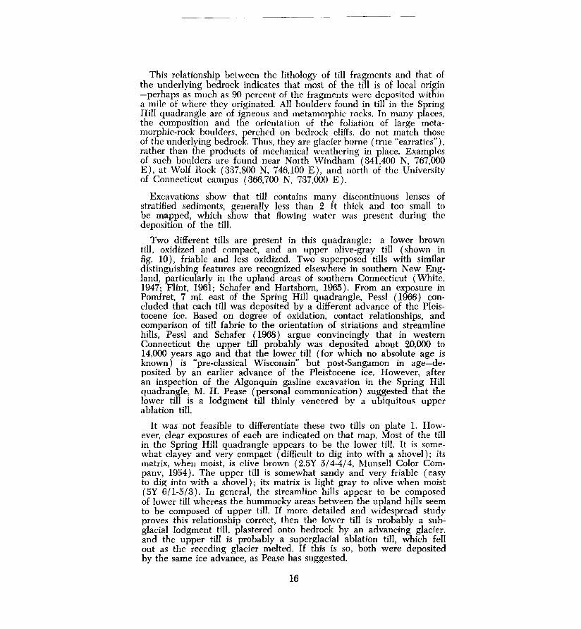
This relationship between the lithology of till fragments and that of the underlying bedrock indicates that most of the till is of local origin -perhaps as much as 90 percent of the fragments were deposited within a mile of where they originated. All boulders found in till in the Spring Hill quadrangle are of igneous and metamorphic rocks. In many places, the composition and the orientation of the foliation of large metamorphic-rock boulders, perched on bedrock cliffs, do not match those of the underlying bedrock. Thus, they are glacier borne (true "earratics"), rather than the products of mechanical weathering in place. Examples of such boulders are found near North Windham ( 341,400 N, 767,000 E), at Wolf Rock (337,800 N, 746,100 E), and north of the University of Connecticut campus (366,700 N, 737,000 E).
Excavations show that till contains many discontinuous lenses of stratified sediments, generally less than 2 ft thick and too small to be mapped, which show that flowing water was present during the deposition of the till.
Two different tills are present in this quadrangle: a lower brown till, oxidized and compact, and an upper olive-gray till (shown in fig. 10), friable and less oxidized. Two superposed tills with similar distinguishing features are recognized elsewhere in southern New England, particularly in the upland areas of southern Connecticut (White, 1947; Flint, 1961; Schafer and Hartshorn, 1965). From an exposure in Pomfret, 7 mi. east of the Spring Hill quadrangle, Pessl ( 1966) concluded that each till was deposited by a different advance of the Pleistocene ice. Based on degree of oxidation, contact relationships, and comparison of till fabric to the orientation of striations and streamline hills, Pessl and Schafer ( 1968) argue convincingly that in western Connecticut the upper till probably was deposited about 20,000 to 14,000 years ago and that the lower till (for which no absolute age is known) is "pre-classical Wisconsin" but post-Sangamon in age-deposited by an earlier advance of the Pleistocene ice. However, after an inspection of the Algonquin gasline excavation in the Spring Hill quadrangle, M. H. Pease (personal communication) suggested that the lower till is a lodgment till thinly veneered by a ubiquitous upper ablation till.
It was not feasible to differentiate these two tills on plate 1. However, clear exposures of each are indicated on that map. Most of the till in the Spring Hill quadrangle appears to be the lower till. It is somewhat clayey and very compact (difficult to dig into with a shovel); its matrix, when moist, is olive brown (2.5Y 5/4-4/4, Munsell Color Companv, 1954). The upper till is somewhat sandy and very friable (easy to dig into with a shovel); its matrix is light gray to olive when moist (5Y 6/1-5/3). In general, the streamline hills appear to be composed of lower till whereas the hummocky areas between the upland hills seem to be composed of upper till. If more detailed and widespread study proves this relationship correct, then the lower till is probably a subglacial lodgment till, plastered onto bedrock by an advancing glacier. and the upper till is probably a superglacial ablation till, which fell out as the receding glacier melted. If this is so, both were deposited by the same ice advance, as Pease has suggested.
16
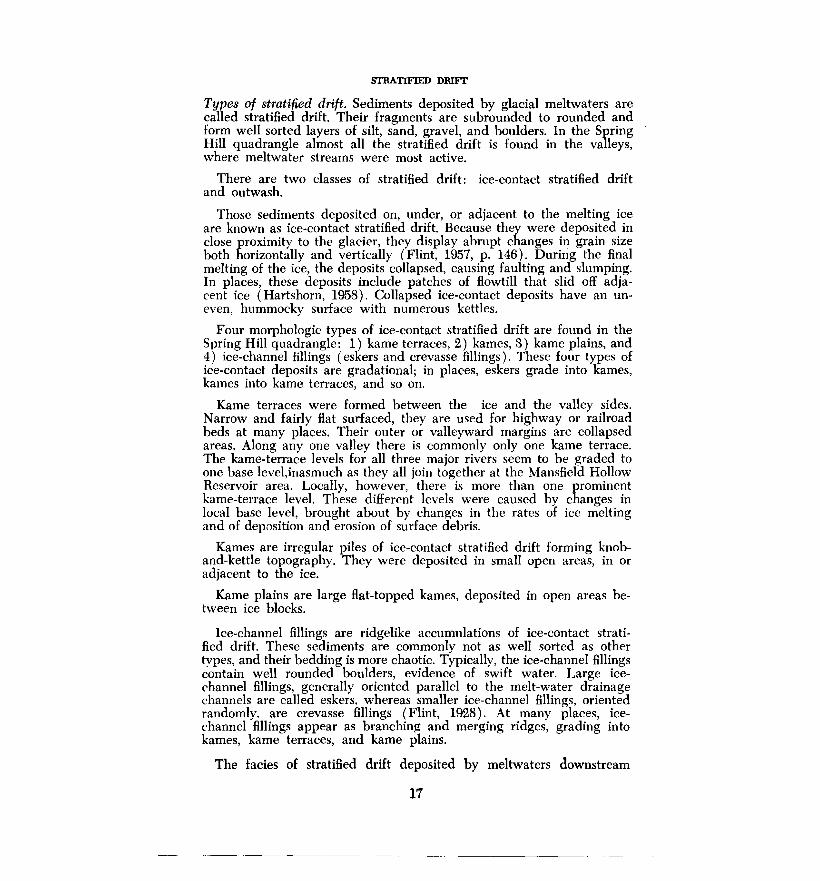
STRATIFIED DRIFT
Types of stratified drift. Sediments deposited by glacial meltwaters are called stratified drift. Their fragments are subrounded to rounded and form well sorted layers of silt, sand, gravel, and boulders. In the Spring Hill quadrangle almost all the stratified drift is found in the valleys, where meltwater streams were most active.
There are two classes of stratified drift: ice-contact stratified drift and outwash.
Those sediments deposited on, under, or adjacent to the melting ice are known as ice-contact stratified drift. Because they were deposited in close proximity to the glacier, they display abrupt changes in grain size both horizontally and vertically (Flint, 1957, p. 146). During the final melting of the ice, the deposits collapsed, causing faulting and slumping. In places, these deposits include patches of flowtill that slid off adjacent ice (Hartshorn, 1958). Collapsed ice-contact deposits have an uneven, hummocky surface with numerous kettles.
Four morphologic types of ice-contact stratified drift are found in the Spring Hill quadrangle: 1) kame terraces, 2) kames, 3) kame plains, and 4) ice-channel fillings ( eskers and crevasse fillings). These four types of ice-contact deposits are gradational; in places, eskers grade into kames, kames into kame terraces, and so on.
Kame terraces were formed between the ice and the valley sides. Narrow and fairly flat surfaced, they are used for highway or railroad beds at many places. Their outer or valleyward margins are collapsed areas. Along any one valley there is commonly only one kame terrace. The kame-terrace levels for all three major rivers seem to be graded to one base level,inasmuch as they all join together at the Mansfield Hollow Reservoir area. Locally, however, there is more than one prominent kame-terrace level. These different levels were caused by changes in local base level, brought about by changes in the rates of ice melting and of deposition and erosion of surface debris.
Karnes are irregular piles of ice-contact stratified drift forming knoband-kettle topography. They were deposited in small open areas, in or adjacent to the ice.
Kame plains are large flat-topped kames, deposited in open areas between ice blocks.
Ice-channel fillings are ridgelike accumulations of ice-contact stratified drift. These sediments are commonly not as well sorted as other types, and their bedding is more chaotic. Typically, the ice-channel fillings contain well rounded boulders, evidence of swift water. Large icechannel fillings, generally oriented parallel to the melt-water drainage channels are called eskers. whereas smaller ice-channel fillings, oriented randomly, are crevasse fillings (Flint, 1928). At many places, icechannel fillings appear as branching and merging ridges, grading into kames, kame terraces, and kame plains.
The facies of stratified drift deposited by meltwaters downstream
17

from the last major buried-ice remnant is called outwash. (Some geologists, however, apply that term to all types of stratified drift.) Outwash, as here defined, is composed of the same type of sediment as ice-contact stratified drift but is better sorted and not slumped or faulted. It is characterized by festoon strata and cross-bedded strata that dip gently downstream. The surface of an outwash deposit generally slopes uniformly away from the former ice surface.
Nearly all bodies of stratified drift in this area lie in the major valleys of the Fenton, Mount Hope, and Natchaug rivers. The stratified drift is most extensive at their confluence in the Mansfield Hollow Reservoir. Small amounts of stratified drift are also present along Stonehouse Brook and in some of the upland areas. These areas are discussed separately below.
Fenton River. In the Fenton River valley, stratified drift appears as kame terraces, kames, and a remarkable series of eskers. A generalized cross section of this valley is shown in figure 3.
Kame terraces flank both sides of the river, and are 10 to 50 ft above present river grade. In some areas, such as along the western side of the river between Chaffeeville and Gurleyville ( 352,000 N, 7 46,300 E), the kame terrace is a well developed topographic terrace, visible on the 1:24,000-scale topographic map. In other areas, such as just south of Route 44A along the eastern side of the river ( 364,000 N, 739,500 E), the kame terrace is a series of collapsed masses that, on aerial photographs, look like landslide debris. Kettles are abundant throughout the kame terrace and are best preserved near Chaffeeville. Fresh exposures show that the kame-terrace deposits consist of beds of sand and gravel that are slumped and contorted by ice collapse at the outward edge (fig. 12).
- FENTON RIVER HILLSLOPE -
I--- !! FT ---j
NO VERTICAL EXAGGERATION
TALUS (SLIDE ROCK)
SAND
BEDDED
GRAVEL
Fig. 12. Sketch of a kame-terrace deposit exposed in a pit along the western side of the Fenton River north of the University of Connecticut ski slope (362,000 N, 739,100 E). The view is to the south; the river is to the left.
18

Sinuous ice-channel fillings ( eskers), 50 ft high and as much as 3,000 ft long, are well preserved in the Fenton River valley. The long axes of the eskers are generally oriented downstream but curve and branch in other directions. There are three parallel eskers in the University of Connecticut well-field area (361,100 N, 740,300 E). The deposits consist of well rounded sand, gravel, cobbles, and bouldersan assemblage typical of swift-water environments. Many of the boulders are more than 1 ft in diameter; a perfectly rounded, spheroidal quartz boulder 2 ft in diameter was found near Well House B ( 361,100 N, 740,300 E).
Ice-contact features (fig. 13) are commonly well displayed in sand-
w
SUDEROCI<
f---- 10 FT ----I NO VERTICAL EXAGGERATION
Fig. 13. Cross sections of eskers. A. An exposure in an excavation for a house south of Route 44A ( 365,000 N, 737,900 E). B. An exposure in a sand-and-gravel pit at the University of Connecticut well field (360,400 N, 741,200 E).
and-gravel pits, yet at one exposure north of Route 44A ( 365,400 N, 737,700 E) none is present. There, in the stratified drift, cobbles of Triassic sandstone as much as six inches in diameter were found-the only glacial material known to be foreign to the quadrangle. No Triassic rocks occur in the entire Fenton River drainage basin, which extends 10 mi. north of this point (nor, indeed, in the entire quadrangle). Judging from the orientation of nearby drumlins, these fragments of Triassic rock were carried by the glacier into the Fenton River basin from a Triassic outcrop area northeast of Springfield, Massachusetts, some 25 mi. to the north northwest, to be reworked by meltwater.
19

At many places, a line of kames leads into an esker; for example, south of Chaffeeville ( 346,000 N, 7 48,.500 E). Basically esker segments, these kames were probably formed by the same general meltwater stream that formed the eskers. In places, isolated kames are found on floodplains or on kame terraces.
Meltwater-current directions, as shown by the stratified-drift deposits in the Fenton River valley, generally coincided with the flow direction of the present river.
Mount Hope River. The deposits of stratified drift along this valley are similar to those in the valley of the Fenton River.
Kame terraces are particularly well developed north of Atwoodvillc (351,000 N, 757,000 E), where Route 89 follows the terrace along its western side. Most of the kame-terrace topography is gently undulating and rarely kettled. The sediments consist of ice-contact sand and gravel similar to that in the Fenton River kame terraces. One exposure along the streambed north of Atwoodville ( 350,300 N, 757,000 E) revealed 5 ft of red and gray varved clay. Several large boulders on the kameterrace surface on the western side of the river north of Atwoodville ( 351,800 N, 757,300 E) were probably ice rafted.
Ice-channel fillings are also present, most of them similar to the eskers in the Fenton River valley. Two small ice-channel deposits south of Warrenville ( 373,800 N, 758,500 E) are apparently crevasse fillings; they are small and flat, with undisturbed bedding in the center (Flint, 1928).
Locally, ice-channel fillings, especially crevasse fillings, grade into kame plains with quite flat surfaces. North of Mount Hope ( 364,000 N, 758,700 E) are two kame plains.
Current directions, as shown in the stratified drift, generally parallel the course of the present Mount Hope River.
Natchaug River. The deposits of stratified drift along this river are not as systematically distributed as those in the Fenton and Mount Hope valleys. In the vicinity of Chaplin (351,700 N, 769,0CO E), a wide kame terrace spreads into the Stonehouse Brook drainage; it was possibly formed when a temporary dam of till or ice blocked the Natchaug River canyon below Chaplin. The distribution of the ice-channel fillings on which Ridge Road is built (west of Chaplin, 351,500 N, 767,600 E), together with the distribution of nearby meltwater spillways, suggests that the meltwaters flowed out from Stonehouse Brook and the Natchaug River and thence across the flat area south of Chaplin. When the temporary dam was breached, meltwater suddenly discharged down Natchaug Canyon. It deposited no stratified drift there; instead, all drift was removed down to bedrock, forming the stretch of rapids and waterfalls known as "Diana's Pool" (fig. 14). Foye ( 1949) described this steep gradient in the Natchaug River as a knickpoint recession from the Appomattox peneplain. It is more logically explained in terms of the history of deglaciation and subsequent meltwater-flow routes.
Mansfield Hollow Reservoir. The deposits of stratified drift along th~
20

Fig. 14. "Diana's Pool," on the l'<atchaug River photographed from the Route 91 bridge (344,900 N, 768,700 E) during high How.
Fenton, Mount Hope, and Natchaug rivers, as well as along such smaller streams as Stonehouse, Buttonball, and Ames brooks, are graded to a vast kame terrace in the Mansfield Hollow Reservoir area, described by Flint ( 1930, p. 196) as " ... a great ice-contact plain." In places the surface is remarkably flat (fig. 15). Most of it, however, is undulating or collapsed, as in the vicinity of Sherman Corner ( 342,-500 N, 767,000E), and marked by numerous kettles, one of which is shown in figure 16. The largest kettle in the quadrangle is Echo Lake ( 340,000 N, 752,300 E). :\lost exposures in this area, even in flat places, exhibit ice-contact structures. A few shew deposits that might be called outwash because of their uniform bedding (fig. 17). However, these areas which lack typical ice-contact sediments do not appear to be very extensive and are not large enough to be mapped on plate 1.
Current directions in the stratified drift suggest that meltwaters had approximately the same flow direction as today's streams.
An excellent example of a kame plain is found just north of Bedlam Corners (347,300 N, 763,900 E).
Two small areas of till northeast of Mansfield Center ( 342,000 N, 753,500 E) are remnants of a landscape that developed on bedrock and premeltwater till and was later buried by the large volumes of stratified drift that now cover this area. The water well in the center of the Mansfield Hollow Reservoir area ( 338,800 N, 752,800 E) reportedly penetrated 137 ft of sand and gravel ( C. E. Thomas and others, 1967).
21

Fig.15. The ice-contact plain (foreground) east of Mansfield Center (338,100 N, 753,600 E), looking west. The plain is underlain by sand and gravel. The hill in the background has a bedrock core, mantled by till. Figure 16 shows stereo aerial photographs of the same area.
Sand and gravel, undifferentiated. Small scattered deposits of sand and gravel are found in lower places on the uplands between the major rivers. These deposits are fairly Rat-lying, although some ice-contact structures are present in them west of Chestnut Hill ( 335,200 N, 737,-100 E). They are pond deposits that accumulated in basins created by irregularities in glacial erosion and deposition. In places, the deposits are built up to the level of a topographic low, or saddle, in the surrounding hills-not necessarily the present drainage outlet. They served as meltwater spillways. The fact that many of these spillways are abandoned suggests that pieces of ice were still present during the accumulation of the deposits, blocking the Row of meltwater and causing local ponding. During the final melting, the waters assumed their present courses. Many of these deposits still lie under pond water.
POSTGLACIAL SEDIMENTS
Terrace Alluvium
A distinct terrace flanks the western side of the Natchaug River below the Mansfield Hollow Dam (336,600 N, 753,200 E). It is about 40 ft below the level of the Mansfield Hollow ice-contact plain and about 20 ft above the present floodplain of the Natchaug River. Because the
22

~
N
l
Fig. 16. Stereo aerial photographs showing till and stratified drift at Mansfield Center. The center of the photographs is at 337,000 N, 752,000 E. The road intersection marked by an X on the photograph is the intersection in the foreground of figure 15. The eastern (right) half of the photographs shows part of the large Mansfield Hollow kame terrace. The arrow points in the direction of meltwater flow, as judged from exposures in the sand-andgravel pit. A large kettle filled with swamp muck can be seen in the upper part of the photographs. The western half of each photograph shows till-mantled bedrock. The Natchaug River and its floodplain are visible to the southeast.

Fig. 17. Exposure in the Mansfield dump (347,300 N, 763,900 E), looking west. Note the current-bedded sands below, capped by 10 ft of gravel, indicating a transition from low- to high-energy fluvial deposition.
Mansfield Hollow ice-contact plain is practically horizontal, and the Natchaug River terrace slopes downstream at approximately the same slope as the present Natchaug River floodplain, the terrace is considered a postglacial stream-cut terrace of the Natchaug River rather than a lower kame-terrace level. Two miles down stream, adjacent to the Willimantic airport on the Willimantic quadrangJe, meanders and arcuate meander scarps suggest that the present floodplain is being formed by postglacial lateral erosion and downcutting by the Natchaug River (Rahn, 1969).
The alluvium on top of the Natchaug River terrace is probably very thin.
Alluvium
The central parts of the major stream valleys are floodplains underlain by thin deposits of Recent alluvium. The elevation of the floodplains below the adjacent kame-terrace elevation reflects the minimum thickness of ice that melted out of the valley after the kame terraces were formed. In addition, there has been some downcutting by streams. This is shown by the numerous exposures of stratified drift in the bottom of the stream channels and by the terrace morphology described above. The alluvium on the floodplains is probably only 5 ft thick, thinner than the stream-channel depth. It consists mainly of overbank silt and fine sand, with some sand and gravel in channel deposits and pointbar deposits.
.24
The floodplain widths in the major river valleys are limited by the position of the kame terraces and ice-channel fillings. In some areas the floodplains developed merely by integrating a series of coalescing kettles, as along the Fenton River north of Mansfield Center ( 344,500 N, 750,000 E). Thus there has been little change in the geomorphology of these areas in postglacial time.
Locally, glaciolacustrine deposits are included in the alluvium. For example, north of the University of Connecticut well field ( 361,000 N, 7:39,500 E ) , seven holes were drilled in 5 acres on the floodplain just upstream from an esker swarm (Rahn, 1968). The holes penetrated 60 ft of uniform fine gray sand and silt without reaching bedrock. These thick deposits probably originated in a glacial or postglacial lake, formed when eskers dammed the Fenton River dowstream. The present river has cut through the eskers.
Swamp muck
The swamps shown on plate 1 were mapped on aerial photographs. They are underlain by decayed vegetation, peat, silt, and sand estimated to be at least 5 ft thick. They are not called swamps simply because they are wet, having intersected a shallow water table, but because they are underlain by distinctive swamp deposits.
In the interstream till uplands, scattered swamps occupy local closed depressions. In Valentine Meadows, a swamp on the University of Connecticut campus ( 357,000 N, 738,SOJ E ), 18 ft of muck was penetrated. Such swamps evidently were ponds immediately following deglaciation, then gradually filled with vegetation and muck. Analyses of pollen from swamps in southern New England ( Deevey, 1943) reveal the plants that have lived in the vicinity during postglacial time. In general, during the past 15,000 years, the vegetation has changed from tundra types to spruce, then to fir, then to pine, and finally to the oak-hickory forests of today.
Nearly all the swamps on stratified drift occupy kettles. Examples can be found north and east of Mansfield Center ( 340,000 N, 752,300 E ) .
Swamp muck has not completely filled all the ponds and kettles; some, such as Echo Lake (340,000 N, 752,300 E), remain as lakes and ponds. Elsewhere, dams have been built to flood swamps, forming ponds such as the one in Lowry Brook east of East Willington ( 377,-000 N, 747,00'.) E) and lakes such as Mirror Lake on the University of Connecticut campus (355,000 N, 737,000 E). Some swamps have been drained in order to graze cattle and grow crops; Valentine Meadows is an example.
Colluvium
Deposits produced by mass-wasting ( colluvium) locally obscure the break in slope between steep till-covered valley walls and the kame terraces. Larger boulders in the till slid downslope and partly filled ravines at the boundaries between till and stratified drift (fig. 18). In
25

WSW
I ORGANIC
SOIL
f----- 20 FT --1 NO VERTICAL EXAGGERATION
KAME TERRACE
FENTON __
RIVER
Fig. 18. Contact between till and stratified drift exposed in an excavation near Chaffeeville (350,300 N, 746,500 E). Large boulders have crept down and come to rest on top of the stratified drift. The outer edge of the kame terrace collapsed as the ice melted, fom1ing ice-contact features in the sediment.
many of the small ravines and depressions along the major rivers, the boulders are numerous enough to form small boulder fields ( 346,000 N, 757,200 E; 354,800 N, 764,800 E).
Most colluvial deposition took place soon after the ice melted, before vegetation stabilized the hillslopes.
Artificial fill
Artificial fill consists of deposits placed by man, such as dams and road fills. Fill is mapped (pl. 1) only where it is known or judged to be at least 5 ft thick and where it is of large enough extent to be shown at the scale of the map. Artificial fill consists of local till, sand and gravel, and trash. The largest earth fill in the quadrangle is the Mansfield Reservoir Dam, almost 2 mi. long and up to 50 ft thick. The dam is veneered with large boulders.
GLACIAL AND POSTGLACIAL HISTORY
The bedrock topography of the Spring Hill quadrangle is essentially pre-Pleistocene; glaciation has modified it only in detail. NW-dipping metamorphic rocks formed a series of SE-facing cuestas or hogbacks and valleys. The Fenton and Mount Hope rivers cut across these rocks as subsequent streams, probably following zones of structural weakness which were developed long before glaciation.
Evidence from the Midwest indicates that northern United States was glaciated at least four times during the last two million years. Evidence of only the last ice advance, the Wisconsin glacial stage, is present in the Spring Hill quadrangle. In the Great Lakes region and in parts of New England (Schafer and Hartshorn, 1965) radiocarbon
26

dating reveals that this glaciation occurred within the last 70,000 years. The ice front probably receded from Connecticut about 15,000 years ago (Schafer and Hartshorn, 1965; Flint, 1965).
The glacier moved SSE, abrading the northern ends of hills and smoothing them to whaleback form. At the same time, it steepened their southern ends by plucking away bedrock, forming stoss-and-lee topography. Most till was deposited as streamline noses or tails of lodgment till; however, in a few areas, till that appears to be of the loose ablation type is found on top of lodgment till.
As melting progressed and ice thinned, the highest hills, such as \Vormwood, Pumpkin, and Spring hills, were exposed first. When lower areas were uncovered, tongues and detached blocks of stagnant ice remained in the valleys. Meltwater flowed around the hills and ice blocks in routes now marked only by scattered, discontinuous deposits of stratified drift, potholed and water-worn bedrock, and abandoned spillways. The large areas of ice-contact stratified drift indicate that stagnation was the main process of deglaciation. It is apparent that the meltwaters initially had complex paths around the ice blocks and formed high-level channels and potholed bedrock. As the ice blocks melted, their influence on the meltwaters diminished, and continuous kame-terrace deposits developed along the valley sides, as in the valleys of the Fenton and Mount Hope rivers. These deposits joined in the Mansfield Hollow to form a large ice-contact plain. Smaller ice-channel fillings, kames, and kame plains were formed by meltwaters in and under the ice. As the last ice melted, ice-contact features, such as slumps, faults, and kettles, developed in most of these meltwater deposits.
Although vegetation and muck are filling ponds that were formed as kettles and lowlands in till, most streams have been relatively underloaded in postglacial time and dissection of the landscape is taking place. The major floodplains, initially outlined by coalescing kettles, are slowly being enlarged by meandering streams. The smaller streams that drain the uplands are cutting ravines into the till slopes. The topography indicates, however, that such postglacial erosion has been minor.
The surficial deposits control the vegetation types. In areas underlain by till, mixed hardwoods are common, whereas pitch pines, juniper, and particularly grasses are more abundant in areas of sand and gravel, sediments that are more permeable than till and hence dry faster.
Postglacial weathering has roughened the natural outcrops of glacially smoothed bedrock. Soil-forming processes have been active on the glacial deposits, forming, in postglacial time, a 1-ft profile of Brown Podzolic soil, typical of that in the northeastern United States.
ECONOMIC GEOLOGY
Sand and gravel
The deposits of stratified drift are valuable for their use in construction, water supply, waste disposal, and roadways. Sand and gravel from many
27
pits were used in the construction of the large earth-fill Mansfield Hollow Dam. Many pits, particularly those along the Fenton River near Gurleyville ( 359,000 N, 7 42,500 E), are still supplying fill for construction.
All modern cemeteries in the quadrangle are on stratified drift. Some old cemeteries are located in till areas, but most of these have been abandoned because of the difficulty of digging in boulder-laden till and the presence of high water tables there. Sand and gravel deposits are easier to dig into and they are better drained.
For the same reasons, the major sanitary landfills are also located in stratified drift. These include the old Mansfield dump ( 339,200 N, 753,500 E) and the present Mansfield dump (347,300 N, 763,900 E).
Highways traverse areas of stratified drift because of their flat surfaces, the ease of bulldozing them, and their good drainage. In other areas of Connecticut sewage-line locations are being chosen with these advantages in mind. The higher areas of stratified drift are the best dwelling sites because of their deep water tables. Shallow water tables in areas of flat-lying till require that houses be built with the cellar floors almost at ground level.
The importance of stratified drift as a source of ground water is discussed below.
Swamp deposits
Swamp muck and some deposits of alluvium are potential sources of peat and soil for lawns and gardens; no known exploitation of these deposits has taken place in this quadrangle.
Ground water
Probably the greatest potential value of the stratified-drift deposits is as sources of ground water.
Almost all houses in the Spring Hill quadrangle have individual wells, either deep ones drilled into bedrock or shallow wells dug in till or stratified drift. Wells in bedrock are the most common but their yields are unpredictable; however, they generally give at least 3 gallons per minute-enough for the average household. Other dwellings have largediameter wells dug into till. Most of these can supply a household with water throughout the year, even though they are only a few feet deeper than the annual low-water level. Wells dug in stratified drift commonly yield large amounts of water because these sediments are generally highly permeable, up to a thousand times more so than till. lce··channel fillings are the coarsest stratified-drift sediments and the most permeable; wells drilled into them would be expected to produce large quantities of water. Three such wells at the University of Connecticut each yield about 400 gallons per minute and together can
2 For a more detailed discussion of the water resources of the Shetucket basin see M. P. Thomas and others (1967) and C. E. Thomas and others (1967).
28

supply more than a million gallons per day (Rahn, 1968).
The ground water in the Spring Hill quadrangle is of good quality. Some wells have a high iron content introduced by chemical weathering of the metamorphic rocks. No major pollution problems are known, although the close spacing of houses with individual wells and septic tanks poses a threat, particularly for wells drilled into bedrock, where there is little ground-water filtration.
29

REFERENCES
Aitken, J. M., 1951, Geology of a section of the Hebron Gneiss of eastern Connecticut: Connecticut Geol. Nat. History Survey Bull. 78, 62 p.
Barrell, Joseph, 1920, The piedmont terraces of the northern Appalachians: Am. Jour. Sci., v. 49, p. 227-258, 327-362, 402-428.
Deevey, E. S., 1943, Additional pollen analyses from southern New England: Am. Jour. Sci., v. 241, p. 717-752.
Dixon, H. R., 1968, Bedrock geology of the Plainfield-Danielson area, Connecticut: unpub. Ph.D. dissert., Harvard Univ., 308 p.
Dixon, H. R., and Pessl, Fred, Jr., 1966, Geologic map of the Hampton quadrangle, Connecticut: U.S. Geo!. Survey Geol. Quad. Map, GQ-468.
Dixon, H. R., and Shaw, C. E., Jr., 1965, Geologic map of the Scotland quadrangle, Connecticut: U.S. Geo!. Survey Geo!. Quad. Map, GQ-392.
Fenneman, N. M., 1938, Physiography of eactern United States: McGraw-Hill Book Co., New York, 714 p.
Flint, R. F., 1928, Eskers and crevasse fillings: Am. Jour. Sci., v. 15, p. 410-416. -----, 1930, The glacial geology of Connecticut: Connecticut Geo!. Nat.
History Survey Bull. 47, 234 p. -----, 1957, Glacial and Pleistocene geology: New York, John Wiley and
Sons, 553 p. , 1961, Two tills in southern Connecticut: Geo!. Soc. America Bull.,
v. 72, p. 1687-1692. -----, 1963, Altitude, lithology, and the fall zone in Connecticut: Jour.
Geology, v. 71, p. 683-697. -----, 1965, The surficial geology of the New Haven and Woodmont quad
rangles: Connecticut Geol. Nat. History Survey Quad. Rept. 18, 42 p. Foye, W. G., 1949, The geology of eastern Connecticut: Connecticut Geo!. Nat.
History Survey Bull., 74, 95 p.
Goldsmith, Richard, 1963, Geologic sketch map of eastern Connecticut: U.S. Geo!. Survey Open-File Report, Nov. 15, 1963, 1 map 1 cross section.
Gregory, H. E., and Robinson, H. H., 1907, Preliminary geologic map of Connecticut: Connecticut Geo!. Nat. History Survey Bull., 7, 39 p.
Hartshorn, J. H., 1958, Flow-till in southeastern Massachusetts: Geo!. Soc. America Bull., v. 69, p. 477-481.
Hubbard, E. L., 1966, General geology and petrology of the west-central ninth of the Spring Hill quadrangle, Connecticut: unpub. M.S. thesis, Univ. Connecticut, 43 p.
Johnson, D. W., 1931, Stream sculpture on the Atlantic slope: New York, Columbia Univ. Press, 142 p.
Munsell Color Company, Incorporated, 1954, Munsell soil-color chart: Baltimore, Maryland.
Percival, J. G., 1842, Report on the geology of the state of Connecticut: New Haven, Connecticut, Osborn and Baldwin, 495 p.
Pessl, Fred, Jr., 1966, A two-till locality in northeastern Connecticut: U.S. Geo!. Survey Prof. Paper 550-D, p. D89-D93.
Pessl, Fred, Jr., and Schafer, J. P., 1968, Two-till problem in Naugatuck-Torrington area, western Connecticut, in Guidebook for field trips in Connecticut: New England Intercollegiate Geo!. Conf., trip B-1, p. 1-12.
30

Rahn, P. H., 1968, The hydrogeology of an induced streambed infiltration area: Ground Water, v. 6, no. 3, p. 21-32.
-----, 1969, The relationship between natural forested slopes and angles of repose for sand and gravel: Geol. Soc. America Bull., v. 80, p. 2123-2138.
-----, 1970, The weathering of tombstones, and its relationship to the topography of New England: Geol. Soc. America Abs., pt. 1, Northeastern Section, p. 32.
Rodgers, John, Gates, R. M., and Rosenfeld, J. L., 1959, Explanatory text for preliminary geologic map of Connecticut, 1956: Connecticut Geo!. Nat. History Survey Bull. 84, 64 p.
Schafer, J. P., and Hartshorn, J. H., 1965, The Quaternary of New England in Wright, H. E., Jr., and Frey, D. G., eds., The Quaternary of the United States: Princeton, New Jersey, Princeton Univ. Press, p. 113-128.
Snyder, G. L., 1964, Bedrock geology of the Willimantic quadrangle, Connecticut: U.S. Geo!. Survey Geo!. Quad. ~lap, GQ-335.
Thomas, M. P., Bednar, G. A., Thomas, C. E., Jr., and Wilson, W. E., 1967, Water resources inventory of Connecticut, pt. 2: Shetucket River basin: Connecticut Water Resources Bull. 11, 96 p.
Thomas, C. E., Jr., Bednar, G. A., Thomas, M. P., and Wilson, W. E., 1967, Hydrogeologic data for the Shetucket River basin, Connecticut: Connecticut Water Resources Bull. 12, 48 p.
White, S. E., 1947, Two tills and the development of glacial drainage in the vicinity of Stafford Springs, Connecticut: Am. Jour. Sci., v. 245, p. 754-778.
Zartman, Robert, Snyder, G. L., Stern, T. W., Marvin, R. F., and Bucknam, R. C., 1965, Implications of new radiometric ages in eastern Connecticut and Massachusetts: U.S. Geo!. Survey Prof. Paper 525-D, 10 p.
The price of this Quadrangle Report is $1.00. Additional copies may be ordered from the State Librarian, State Library, Hartford, Connecticut 06115 (postpaid; Connecticut residents must add sales tax). Like all publications of the Connecticut Geological and Natural History Survey, one copy is available, free of charge, to public officials, exchange libraries, scientists, and teachers who indicate to the State Librarian, under their official letterhead, that it is required for professional work. A List of Publications of the State Survey is also available from the State Librarian upon request.
31
-------------------------------------·-----