The State of the Dragon Run Watershed - Middle Peninsula
34
The State of the Dragon Run Watershed: Status of Natural Resources December 2003 By the Dragon Run Steering Committee, Middle Peninsula Planning District Commission This report was funded, in part, by the Environmental Protection Agency's Chesapeake Bay Program through the Virginia Department of Conservation and Recreation, via grant agreement number BAY-2002-20-SR. The views expressed herein are those of the authors and do not necessarily reflect the views of DCR.
Transcript of The State of the Dragon Run Watershed - Middle Peninsula

The State of the Dragon Run Watershed: Status of Natural Resources
December 2003
By the Dragon Run Steering Committee, Middle Peninsula Planning District Commission
This report was funded, in part, by the Environmental Protection Agency's Chesapeake Bay Program through the Virginia Department of Conservation and Recreation, via grant agreement number BAY-2002-20-SR. The views expressed herein are those of the authors and do not necessarily reflect the views of DCR.

Acknowledgements This report was funded, in part, by the Environmental Protection Agency's Chesapeake Bay Program through the Virginia Department of Conservation and Recreation, via grant agreement number BAY-2002-20-SR. This report was compiled by David Fuss of the Middle Peninsula Planning District Commission under the auspices of the Dragon Run Steering Committee’s Dragon Run Special Area Management Plan (SAMP) project. The Dragon Run SAMP project was funded by the Department of Environmental Quality’s Virginia Coastal Program through Grants #NA17OZ1142-01 and #NA17OZ2355 and #NA03NOS4190104 of the National Oceanic and Atmospheric Administration, Office of Ocean and Coastal Resource Management, under the Coastal Zone Management Act of 1972, as amended. The views expressed herein are those of the authors and do not necessarily reflect the views of DCR, DEQ, EPA, or NOAA.
2

Table of Contents Chapter 1: Introduction 4 Chapter 2: Natural Resources in the Dragon Run 5 Chapter 3: Conclusion 21 Literature Cited 22 Appendix A: Natural Heritage Resources 25 Appendix B: Fishes and Macroinvertebrates 28 Appendix C: Soils 32
3

Chapter 1: Introduction The Dragon Run “encompasses some of the most extensive and unspoiled swamp forest and woodland communities in Virginia” (Belden, Jr. et al, 2001). Bisecting Virginia’s Middle Peninsula, this fresh and brackish water stream (Figure 1) meanders forty miles along and through nontidal and tidal cypress swamp. The watershed is mostly undeveloped and privately owned and encompasses approximately 140 square miles (90,000 acres) of rural landscape – primarily forests, farms, and wetlands. The spring-fed Dragon Run flows through Essex, King and Queen, Middlesex, and Gloucester Counties into the estuarine Piankatank River and the Chesapeake Bay.
Figure 1. The Dragon Run The watershed’s wilderness is both expansive and unique. The Dragon Run contains the northernmost example of the Baldcypress-Tupelo Swamp natural community in Virginia and the best example north of the James River (Belden, Jr. et al., 2001). Based on his investigations, one researcher observes that the Dragon Run is a “100 year old time capsule,” resembling coastal plain streams in the Chesapeake Bay watershed at the turn of the 20th century (Garman, 2003). This report attempts to document the status of the natural resources in the Dragon Run watershed as part of a comprehensive watershed management planning effort. The State of the Dragon Run Watershed is intended as an environmental baseline to which to compare the results of watershed management planning on the watershed’s unique natural resources.
4

Chapter 2: Natural Resources in the Dragon Run Physical and Environmental Factors Located within the coastal plain physiographic province, Virginia’s Middle Peninsula is bordered by the Rappahannock River to the north, the York River to the south, and the Chesapeake Bay to the east. At the Middle Peninsula’s center, the Dragon Run watershed expands outward from its 40-mile fresh and brackish water stream that runs through Essex, Gloucester, King and Queen, and Middlesex Counties. The watershed encompasses 90,000 acres or 140 square miles and exhibits topography typical of coastal plain stream systems in Virginia. Table 1 shows watershed area by locality. County Area within Locality
(acre) % of Total Watershed
% of Locality within Watershed
Essex 18466.6 20.6 10.1 Gloucester 5671.7 6.3 3.1 King and Queen 46425.1 51.7 22.2 Middlesex 19207.7 21.4 16.3 Total 89771.1 100
Table 1. Dragon Run watershed statistics by locality (from MPPDC, 2001).
The Dragon Run watershed, state hydrologic unit CO2, is a fourth-order stream system that is nontidal freshwater above the U.S. Route 17 bridge and tidal freshwater from the U.S. 17 bridge to its mouth at Meggs Bay (Figure 2). At its mouth, it forms the estuarine Piankatank River and eventually drains into the Chesapeake Bay (Figure 3). The Dragon Run’s streamflow is supported by underground springs, feeder swamps, and surface waters. Significant tributaries include Dragon Swamp, Yonkers Swamp, Exol Swamp, Timber Branch Swamp, Briery Swamp, Holmes Swamp, White Marsh, Zion Branch, Carvers Creek, Mill Stream, and Meggs Bay (MPPDC, 2001). The Dragon Run watershed lies within the transitional Oak-Pine vegetation region. Land cover data indicate that the watershed is 80.3-83.9% forested and wetlands, 15.1-18.4% agricultural, and 1.0-1.3 % commercial and residential (MPPDC, 2002; DCR, 2003b). Although loblolly pine originally appeared in the forest as scattered associates of oaks and other hardwoods, loblolly pine plantations are increasingly common. The relatively intact watershed contains many unique resources. Natural heritage resources are abundant in the Dragon Run (see Appendix A). Several rare natural communities occur in the Dragon Run, including Baldcypress-Tupelo Swamp, Tidal Baldcypress-Tupelo Swamp, Tidal Baldcypress Woodland/Savanna, Fluvial Terrace Woodland, and Tidal Freshwater Marsh.
5

Figure 2. The Dragon Run watershed boundary showing villages and towns (from MPPDC, 2003b).
6

Figure 3. The Dragon Run watershed (in green) flowing into the Piankatank River and the Chesapeake Bay (from MPPDC, 2003b).
7

The Baldcypress-Tupelo Swamp community harbors a number of rare plant and animal species. Rare animals include bald eagle, great purple hairstreak, blackwater bluet, robust baskettail, cypress sphinx, Selys’ sunfly, fine-lined emerald and Southern pitcher-plant mosquito. Rare plants include cuckooflower, red turtlehead, Parker’s pipewort, pineland tick-trefoil, river bulrush, Northern purple pitcher-plant, and cypress-knee sedge (Belden, Jr. et al., 2001; Belden, Jr. et al., 2003). The Dragon Run also harbors a number of rookeries for colonial water birds, such as egrets and herons. Natural communities that occur in the headwaters of the Dragon Run include: Coastal Plain/Piedmont Bottomland Forest; Coastal Plain/Piedmont Acidic Seepage Swamp; and Coastal Plain Semipermanent Impoundment (Belden, Jr. et al., 2003). In addition to natural heritage resources, the Dragon Run supports a diversity of freshwater and estuarine fishes, aquatic macroinvertebrates, freshwater bivalves (primarily unionid mussels), and herptefauna (amphibians and reptiles) (McIninch et al., 2003). At least forty-five fish species from nineteen families have been collected in the Dragon Run, representing a mixed assemblage of mostly lowland freshwater forms that is highly dynamic spatially and temporally (see Appendix B). At least sixty-five macroinvertebrate species from fourteen orders and forty-seven families have been recorded from the Dragon Run (see Appendix B). The watershed contains limited examples of invasive, or non-native, species, again emphasizing a relatively intact natural system. Currently, blue catfish, common reed, Asiatic dayflower and Japanese stiltgrass occur in the Dragon Run in limited quantities. According to the National Wetland Inventory, wetlands along the Dragon Run (Figure 4) are Palustrine, mostly Forested Wetlands except for Emergent Wetlands in Meggs Bay. U.S. Route 17 is the approximate demarcation between tidal wetlands and non-tidal wetlands. The hydrologic regime of most Dragon Run wetlands is Seasonally Flooded, Seasonally Flooded-Saturated, or Temporarily Flooded (Belden, Jr. et al., 2001). The U.S. Geological Survey (USGS) maintained a streamflow gaging station at Church View (Route 602) from 1943 to 1981 that received drainage from 60% of the watershed (84 square miles) and has maintained a streamflow gaging station at Mascot (Route 603) since 1981 that receives drainage from 75% of the watershed (105 square miles). Median daily streamflow at Mascot from 1981 to 1999 was 79 ft3/sec and varied between 0.01-6050 ft3/sec. Median daily streamflow at Church View from 1943 to 1981 was 57 ft3/sec and varied from 0-3790 ft3/sec. Compared to other coastal plain stream systems such as the Chickahominy River (New Kent County), the Mattaponi River (King William County), and Cat Point Creek (Richmond County), the Dragon Run exhibits lower median daily streamflow per square mile of drainage area. Base flow, fed primarily by groundwater discharge, accounts for two-thirds of the Dragon Run’s total streamflow, with the remaining third attributable to surface water runoff. Of the annual precipitation, only one-third becomes streamflow, with two-thirds lost to evapotranspiration. Seasonally, streamflow is highest in the spring and lowest in the fall (MPPDC, 2001).
8

Figure 4. Wetlands in the Dragon Run watershed (from MPPDC, 2003).
9

Geological features are described by the following excerpt from A Natural Heritage Inventory of the Dragon Run Watershed (Belden, Jr. et al., 2001): Surficial deposits of riverine terraces bordering Dragon Run from the vicinity of the Essex-Middlesex county line to Meggs Bay belong to the Shirley Formation and the Sedgefield Member of the Tabb formation. The middle Pleistocene Shirley Formation consists of light- to dark-gray, bluish-gray and brown sand, gravel, silt, clay, and peat; the Sedgefield Member is of upper Pleistocene age and consists of pebbly to bouldery, clayey sand and fine to medium, shelly sand grading upward to sandy and clayey silt. Somewhat higher topography away from the waterway is underlain by the Chesapeake Group. This consists of fine to coarse quartzose sand, silt, and clay (variably shelly and diatomaceous) deposited in shallow waters of the upper Pliocene and lower Miocene periods. At still higher elevations, the Windsor Formation is found, consisting of gray and yellowish to reddish-brown sand, gravel, silt, and clay of lower Pleistocene or upper Pliocene age. At higher elevations southwest of Dragon Run, two other formations are prevalent, both of upper Pliocene age. The Bacons Castle Formation is characterized by gray, yellowish-orange, and reddish-brown sand, gravel, silt, and clay and the Moorings Unit by white, light gray, and grayish-yellow quartzose sand and clay to grayish-brown clayey silt and silty clay. Watershed elevation ranges from 180 feet to near sea-level. Detailed soils information (see Appendix C) can be found in the Soil Survey for each county (Note: King and Queen County does not have a published Soil Survey). Many of these soils are considered prime farmland and are suitable for silviculture. Generally, soil associations are as follows:
Essex County Emporia-Slagle-Atlee; Rumford-Suffolk-Emporia - somewhat excessively drained to moderately well drained loamy and sandy soils (Hoppe, 1989)
Middlesex County Suffolk-Eunola-Remlik; Kempsville-Suffolk-Kinston; Emporia-Slagle-Nevarc - deep, well drained to poorly drained loamy or clayey soils (Newhouse et al., 1985); Pocaty-Kinston-Bibb - deep, very poorly to poorly drained organic and loamy soils that are flooded by fresh and brackish water (Newhouse et al., 1985)
Gloucester County Suffolk-Eunola-Kenansville; Emporia-Hapludults-Wrightsboro - deep, well drained to moderately well drained loamy or clayey soils (Newhouse et al., 1980)
DCR’s Shoreline Erosion Advisory Service identified five areas of streambank erosion in the lower Dragon Run (Vanlandingham, 2003). The lower Dragon Run undergoes an average of less than one foot per year of erosion that is mostly attributable to high water flow undercutting the stream bank during storms. These erosion “hot spots” are relatively few and small and are unlikely to cause impairment to the stream. Water Quality Water Quality Assessment The primary water contaminant sources in the Dragon Run are point source discharges and nonpoint source pollution from precipitation (atmospheric deposition), residential
10

land use, agricultural land use, and forested lands (MPPDC, 2002). According to the Virginia Department of Environmental Quality (DEQ), the Dragon Run generally exhibits medium nutrient levels and is listed as “impaired” for pH, fecal coliform bacteria, mercury, and lead (DEQ, 2002). Based on agricultural, urban, and forested pollution loadings potential determined by DCR, however, the overall nonpoint source pollution potential rating is low for the Dragon Run (DCR, 2002). Point source discharges, which are permitted and monitored by the Virginia Department of Environmental Quality, are relatively easy to quantify and, in turn, control or track. Point source discharges to the Dragon Run include: stormwater runoff from a wood treatment facility (arsenic, chromium, copper) at Pitts Lumber Company, Inc. to an intermittent stream adjacent to U.S. Route 17 in Middlesex County (Permit #VA0083011); discharge from a sewage treatment plant (biological oxygen demand, total suspended solids, ammonia nitrogen, total residual chlorine, pH, fecal coliform) at Rappahannock Community College to an intermittent stream near Glenns in Gloucester County (Permit #VA0028461); and discharge from a wellwater treatment plant (pH, total suspended solids) at the Miller’s Square Subdivision to an intermittent stream near Miller’s Tavern in Essex County (Permit #VA0075302). According to the Shoreline Sanitary Survey (Smither et al., 2003), there are 9 other indirect sources of pollution, including five animal pollution sources (Middlesex County near Saluda and Stormont and Gloucester County near Glenns); a solid waste dumpsite in Middlesex County near Stormont; and a potential pollution source in Middlesex County in Saluda. Furthermore, a network of water quality monitoring wells is maintained at the Browning-Ferris Industries landfill in King and Queen County. Throughout the Chesapeake Bay, atmospheric deposition (e.g. precipitation) contributes a significant amount of the total nutrient loadings in coastal waters (MPPDC, 2001). Air quality is not currently monitored in the watershed. More than 90% of residents in Gloucester, King and Queen, and Middlesex Counties use on-site wastewater treatment systems, commonly known as septic systems (MPPDC, 2001). When operated properly, conventional septic systems remove nutrients and fecal coliform. Conventional septic systems can pose potential environmental and health risks due to inappropriate design, poor maintenance, poor soils, or inefficient nitrogen removal. Driven by changes to Department of Health regulations for on-site wastewater treatment systems (12 VAC 5-610-10 et seq. effective July 2000), the popularity of “engineered” on-site wastewater treatment systems is increasing. These alternative systems, when properly maintained, can be effective at removing nutrients and fecal coliform in areas where conventional septic systems are ineffective. Regardless of the type, however, improperly maintained or failing septic systems pose significant environmental and health risks by contributing nutrients, pathogenic bacteria, and viruses to groundwater.
11

Forested lands, representing a significant land area, yield low nutrient input to streams relative to other land uses in the watershed. Best Management Practices (BMPs) are designed to minimize these inputs. For example, forested riparian buffers provide effective protection for water quality. The watershed currently exhibits intact riparian buffers. By contrast, agricultural land use in rural and semirural areas in Virginia can be the source of significant sediments, fecal coliform bacteria, and nutrients such as nitrogen and phosphorus. Nitrogen is transported through the groundwater, whereas phosphorus is generally transported on soil particles in surface water. BMPs such as fencing cattle out of streams, conservation tillage, and expanded riparian buffers are designed to minimize these inputs. Residential and commercial land uses typically contribute less nutrients and sediments than agriculture, but more than forestry. These residential and commercial contributions are mainly attributable to reduced or no riparian buffers, chemical application for landscaping, and stormwater runoff. Water Quality Monitoring Water quality data sets in the watershed are sparse in quantity, duration, and parameters measured. Existing data sets include: STORET, a database managed by the Virginia Department of Environmental Quality (DEQ); data collections during fish surveys by the Virginia Department of Game and Inland Fisheries (DGIF) and Virginia Commonwealth University (VCU); data collections by the Chesapeake Bay National Estuarine Research Reserve in Virginia at the Virginia Institute of Marine Science (VIMS); and a now-defunct volunteer water quality monitoring program in the watershed (MPPDC, 2001). Two stations are currently sampled regularly by the DEQ. Station DRN003.40 is located at the U.S. Route 17 bridge and Station DRN010.48 is located at the Route 603 bridge near Mascot. Data are available from DRN003.40 for the period 1968-1974 and 1992-present and from DRN010.48 for the period 1992-present. Samples are evaluated bimonthly for nutrients, fecal coliform, suspended solids, dissolved oxygen, pH, salinity, and temperature and are occasionally evaluated for pesticides, toxic metals, and other harmful compounds (MPPDC, 2001). The data sets collected at these sampling stations were used by the DEQ to list the Dragon Run as “impaired” for pH and fecal coliform bacteria. Fish tissue samples were used by the DEQ to list the Dragon Run as “impaired” for mercury and lead. The Virginia Department of Health issued a health advisory for the Dragon Run for mercury contamination in largemouth bass (DOH, 2003). The DEQ attributes the pH impairment to natural causes, citing the acidic nature of water in swamps. The DEQ lists the cause of the fecal coliform and mercury and lead impairments as unknown. Potential sources of fecal coliform bacteria include: wildlife; failing septic systems; and livestock. Potential sources of metals include: atmospheric deposition; automobile and roadway deposits; and industrial operations.
12

Data collected by the DGIF in 1995-1996 and 1998 includes temperature, Secchi depth, pH, dissolved oxygen, conductivity, salinity, alkalinity, hardness, and total dissolved solids. Nutrient data are very limited and were frequently below detection limits. Dissolved oxygen at sampling stations with no or low flow frequently violated daily minimum standards to support aquatic life (MPPDC, 2001). VIMS data from 2000-2001 measured temperature, salinity, total dissolved solids, pH, dissolved inorganic nitrogen, and fecal coliform bacteria. Of specific note, samples from Briery Swamp exhibited high nitrate and fecal coliform levels, indicating the presence of subsurface agricultural or wastewater drainage (MPPDC, 2001). A weekly volunteer water quality monitoring program collected data throughout the watershed during the period 1994-1997, although monitoring was not continuous at all eight sites. Measurements included dissolved oxygen, Secchi depth, water and air temperature, pH, and water color. The findings indicated: low dissolved oxygen during warm temperatures and high dissolved oxygen during cold temperatures; low Secchi depth values during the summer associated with algal blooms and storm events; and acidic pH values in the upper Dragon Run with slightly more basic pH values in the tidal waters (MPPDC, 2001). Impervious Cover The percentage of impervious surface is a key indicator of water quality status and stream health. The Dragon Run watershed exhibits low impervious cover and, in turn, is in good condition (e.g. natural heritage resources). Impervious surfaces (e.g. paved streets and parking lots, rooftops) are areas that do not allow rainwater to infiltrate into the soil, promoting runoff to streams. Runoff is often at a higher volume and velocity than normal stream flow, frequently leading to stream erosion and instability. Runoff also carries pollutants that can lead to degraded water quality. The Center for Watershed Protection (2002) has developed a watershed vulnerability analysis that relies on an impervious cover model. The model indicates that watersheds are generally in good condition when impervious cover is less than 10%. From 10-25% impervious cover, watersheds are generally impacted, which means that they only partially support their intended uses (e.g. drinking, swimming, shellfish harvest). Above 25% impervious cover, watersheds generally do not support their intended uses at all. Impervious cover can be estimated for the Dragon Run watershed. Based on 1994 aerial photography, 1.3% of the watershed is commercial or residential development. Conservatively assuming 100% imperviousness, the watershed is approximately 1.3% impervious surface, with the sparse road network adding modestly to this estimate. Since the Dragon Run watershed exhibits less than 10% impervious cover, the Center for Watershed Protection’s model (2002) predicts that it is in good condition, which is confirmed by the MPPDC’s Dragon Run Watershed Land-Water Quality Preservation Project (MPPDC, 2001).
13
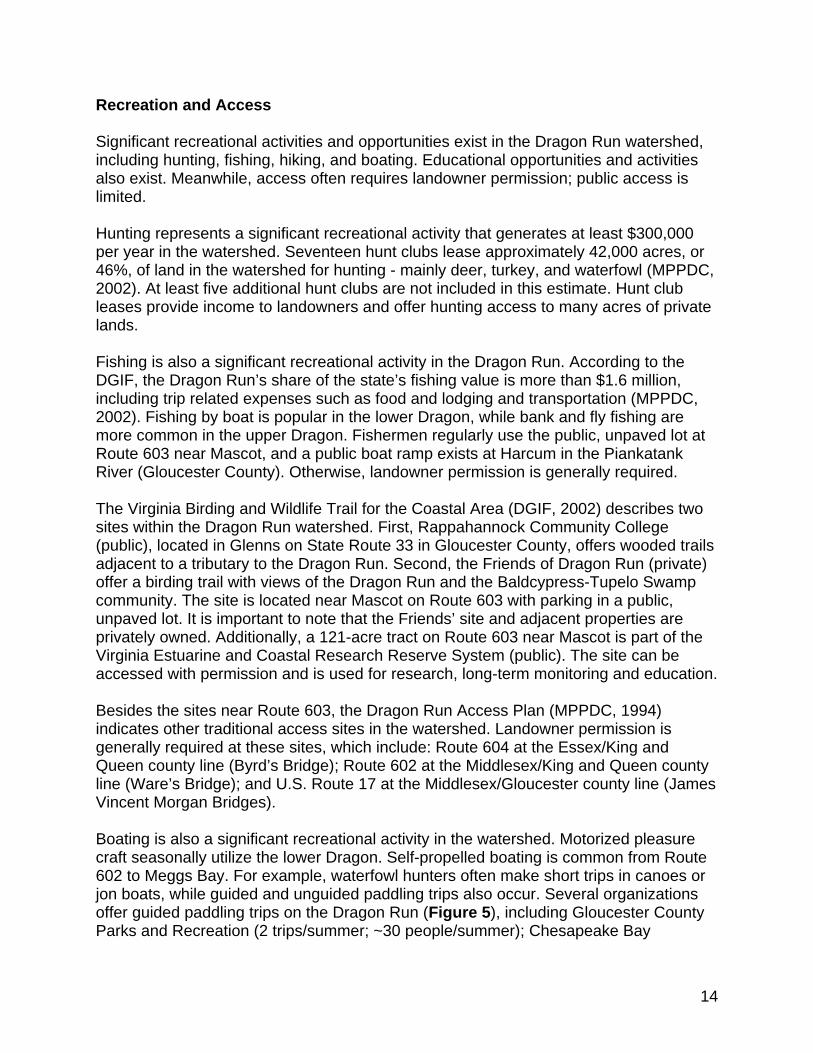
Recreation and Access Significant recreational activities and opportunities exist in the Dragon Run watershed, including hunting, fishing, hiking, and boating. Educational opportunities and activities also exist. Meanwhile, access often requires landowner permission; public access is limited. Hunting represents a significant recreational activity that generates at least $300,000 per year in the watershed. Seventeen hunt clubs lease approximately 42,000 acres, or 46%, of land in the watershed for hunting - mainly deer, turkey, and waterfowl (MPPDC, 2002). At least five additional hunt clubs are not included in this estimate. Hunt club leases provide income to landowners and offer hunting access to many acres of private lands. Fishing is also a significant recreational activity in the Dragon Run. According to the DGIF, the Dragon Run’s share of the state’s fishing value is more than $1.6 million, including trip related expenses such as food and lodging and transportation (MPPDC, 2002). Fishing by boat is popular in the lower Dragon, while bank and fly fishing are more common in the upper Dragon. Fishermen regularly use the public, unpaved lot at Route 603 near Mascot, and a public boat ramp exists at Harcum in the Piankatank River (Gloucester County). Otherwise, landowner permission is generally required. The Virginia Birding and Wildlife Trail for the Coastal Area (DGIF, 2002) describes two sites within the Dragon Run watershed. First, Rappahannock Community College (public), located in Glenns on State Route 33 in Gloucester County, offers wooded trails adjacent to a tributary to the Dragon Run. Second, the Friends of Dragon Run (private) offer a birding trail with views of the Dragon Run and the Baldcypress-Tupelo Swamp community. The site is located near Mascot on Route 603 with parking in a public, unpaved lot. It is important to note that the Friends’ site and adjacent properties are privately owned. Additionally, a 121-acre tract on Route 603 near Mascot is part of the Virginia Estuarine and Coastal Research Reserve System (public). The site can be accessed with permission and is used for research, long-term monitoring and education. Besides the sites near Route 603, the Dragon Run Access Plan (MPPDC, 1994) indicates other traditional access sites in the watershed. Landowner permission is generally required at these sites, which include: Route 604 at the Essex/King and Queen county line (Byrd’s Bridge); Route 602 at the Middlesex/King and Queen county line (Ware’s Bridge); and U.S. Route 17 at the Middlesex/Gloucester county line (James Vincent Morgan Bridges). Boating is also a significant recreational activity in the watershed. Motorized pleasure craft seasonally utilize the lower Dragon. Self-propelled boating is common from Route 602 to Meggs Bay. For example, waterfowl hunters often make short trips in canoes or jon boats, while guided and unguided paddling trips also occur. Several organizations offer guided paddling trips on the Dragon Run (Figure 5), including Gloucester County Parks and Recreation (2 trips/summer; ~30 people/summer); Chesapeake Bay
14

Foundation (since 1995, 56 trips; 1080 people; for middle and high school students in Middlesex and Gloucester Counties); Rappahannock Community College (1 3-day trip/year; ~20 people); and Friends of Dragon Run (15-20 trips/year; ~200 people/year). Some outdoor outfitters offer guided trips by appointment.
Figure 5. Guided paddling trip on the Dragon Run. Watershed Education Limited watershed education efforts include workshops, field trips, and publications. Soil and Water Conservation Districts, Virginia Cooperative Extension, and the Natural Resources Conservation Service offer a variety of workshops, seminars, and publications related to watersheds, nonpoint source pollution, agriculture, and forestry. These programs mainly target those involved in agriculture and forestry activities. Rappahannock Community College and the Chesapeake Bay Foundation both lead students on paddle trips. The Friends of Dragon Run offer paddle trips to citizens and decision-makers. Finally, local governments provide publications explaining land use regulations. For example, King and Queen and Middlesex Counties distribute fact sheets about pertinent ordinances to new and prospective property owners. Infrastructure Road Network The road network within the watershed is sparse (Figure 6). The primary highways are U.S. Route 17, which runs north and south through Gloucester, Middlesex, and Essex Counties, and State Route 33, which runs east and west through King and Queen, Gloucester, and Middlesex Counties. These two highways intersect at Glenns in Gloucester County and Saluda in Middlesex County. A short length of State Route 198, a primary highway, runs east from Glenns in Gloucester County before leaving the watershed.
15

Figure 6. Road network in the Dragon Run watershed (from MPPDC, 2003b).
16

There is a sparse network of secondary roads, some of which serve as connectors along the road network. Route 603 and Route 602 both cross the middle Dragon Run and connect King and Queen and Middlesex Counties. Route 604 and Route 612 both cross the upper Dragon Run and connect Essex and King and Queen Counties. Route 684 serves as a connector between U.S. Route 17 and U.S. Route 360 in Essex County. Several other secondary roads serve as significant links within the road network. Examples of these are: Route 644 in Middlesex County; Routes 609, 610, 616, and 617 in King and Queen County; and Route 607 in Essex County. Finally, there is a network of unpaved logging, farm, and residential roads that access the more remote parts of the watershed. Land Parcels According to data collected in 2001, there are 3,073 parcels of land in the Dragon Run watershed (MPPDC, 2002). The distribution of parcels is: Essex (25%); Gloucester (11%); King and Queen (38%); and Middlesex (26%). The land area within the watershed is distributed as follows: Essex (21%); Gloucester (6%); King and Queen (52%); and Middlesex (21%). Comparing the distribution of parcels to the distribution of land area within the watershed, we find that Essex, Gloucester, and Middlesex Counties have a higher percentage of parcels than of land area, meaning that they have smaller average parcel sizes than King and Queen County. King and Queen County has a much higher percentage of land area than of parcels, indicating a much larger average parcel size than the other three counties. Land ownership is almost entirely private. A considerable amount of private land is owned by timber interests. For example, the single largest owner, John Hancock Life Insurance Company, owns approximately 26,000 acres (28.9% of the watershed). Much of this timber land is, in turn, leased to hunt clubs. Public ownership includes the College of William and Mary (121 acres) and the Virginia Department of Transportation (fee simple and prescriptive easements for roads and right-of-way). Structures Interpretation of digital orthophoto quadrangles from 1994 revealed that there were 1,311 structures or clusters of structures (e.g. barns and accessory buildings) in the Dragon Run watershed (MPPDC, 2002). As expected, the majority of the structures are located along the primary highways and, to a lesser degree, along the secondary road network. It is likely that population growth and accompanying residential structures will continue to follow this pattern. Conservation The Virginia Division of Natural Heritage (DCR, 2003a) has established conservation planning boundaries (Figure 7) around natural heritage resources based on their habitat needs. These conservation sites represent the ideal conservation scenario for these state and globally rare resources. Some of these resources have been conserved, either through fee simple purchase or purchase of conservation easements (Figure 8). Conservation easements are held on 235 acres by the Virginia Outdoors
17

Figure 7. Natural heritage conservation sites for the Dragon Run watershed (from MPPDC, 2003b).
18

Figure 8. Conservation easements in the Dragon Run watershed (from MPPDC, 2003b).
19

Foundation, 72 acres by Friends of Dragon Run, and 32 acres by the Chesapeake Bay Foundation. The Nature Conservancy currently owns 452 acres and intends to purchase 2,440 acres over the next several months. Some of this land will ultimately be owned and managed by the Department of Forestry and the Middle Peninsula Chesapeake Bay Public Access Authority. Identified Data Gaps The status of invasive species in the Dragon Run is partially known. Efforts to gather more detailed information about invasive species, primarily common reed and blue catfish, are underway. Other data gaps are not being addressed at this time. For example, there is scant information about migratory birds, other than highly specific research (e.g. bald eagle nesting assessment, colonial bird nesting assessment) and amateur observational records. Another data gap that is not currently being addressed is the source of water quality impairments (e.g. pH, fecal coliform, mercury, lead) for stream segments on the Virginia 303(d) list (DEQ, 2002). It is assumed that pH impairment is from natural sources (i.e. swamps are naturally acidic). Development of Total Maximum Daily Loads (TMDL) for impairments in Dragon Run stream segments are planned by the Virginia Department of Environmental Quality (DEQ) in 2010.
20

Chapter 3: Conclusion
The Dragon Run is a unique watershed from a natural, cultural, and historical perspective. Due to its relatively undeveloped condition, it harbors many unique resources unlike other places throughout the Chesapeake Bay watershed. This report attempts to document the status of the natural resources in the Dragon Run watershed as part of a comprehensive watershed management planning effort. The Dragon Run Watershed Management Plan (2003b) is a collaborative endeavor designed to manage the watershed at an ecosystem-scale rather than on a solely jurisdictional basis. The State of the Dragon Run Watershed is intended as an environmental baseline to which to compare the results of watershed management planning on the watershed’s unique natural resources.
21

Literature Cited Belden, A. Jr., A.C. Chazal, G.P. Fleming, C.S. Hobson, and K.M. McCoy. 2001. A
Natural Heritage Inventory of the Dragon Run Watershed. Second edition. Natural Heritage Technical Report 01-03. Virginia Department of Conservation and Recreation, Division of Natural Heritage, Richmond, VA. 64 pp. plus appendix.
Belden, A. Jr., A.C. Chazal, and C.S. Hobson. 2003. A Natural Heritage Inventory of
Fourteen Headwater Sites in the Dragon Run Watershed. Natural Heritage Technical Report 03-16. Virginia Department of Conservation and Recreation, Division of Natural Heritage, Richmond, VA.
Center for Watershed Protection. 2002. Watershed Vulnerability Analysis. Center for
Watershed Protection, Ellicott City, MD. http://www.cwp.org. Department of Conservation and Recreation. 2002. The Biennial Nonpoint Source
Pollution Water Quality Assessment Report. Virginia Department of Conservation and Recreation, Division of Soil and Water Conservation, Richmond, VA.
Department of Conservation and Recreation. 2003a. Natural Heritage Resources Maps.
Virginia Department of Conservation and Recreation, Division of Natural Heritage, Richmond, VA.
Department of Conservation and Recreation. 2003b. Virginia 2002 Nonpoint Source
(NPS) Assessment Landuse/Area web site. Virginia Department of Conservation and Recreation, Division of Soil and Water Conservation, Richmond, VA. http://192.206.31.52/cfprog/dswc/lutype.cfm.
Department of Environmental Quality. 2002. 2002 303(d) Report on Impaired Waters.
Virginia Department of Environmental Quality, Richmond, VA. http://www.deq.state.va.us/water/303d.html.
Department of Game and Inland Fisheries. 2002. Virginia Birding and Wildlife Trail:
Coastal Area. Virginia Department of Game and Inland Fisheries, Richmond, VA. http://www.dgif.state.va.us/wildlife/vbwt/trail.asp.
Department of Health. October 29, 2003. Press Release: Virginia Department of Health
Issues Fish Consumption Advisories for Four Locations. Virginia Department of Health, Richmond, VA. http://www.vdh.state.va.us/news/PressReleases/2003/102903FishConsumption.asp.
22

Fleming, G.P., P.P. Coulling, D.P. Walton, K.M. McCoy, and M.R. Parrish. 2001. The natural communities of Virginia: classification of ecological community groups. First approximation. Natural Heritage Technical Report 01-1. Virginia Department of Conservation and Recreation, Division of Natural Heritage, Richmond, VA. Unpublished report. January 2001. 76 pp.
Garman, G.C. 2003. Aquatic Living Resources Inventories in the Dragon System:
Virginia Commonwealth University On-going Activities. Dragon Run Natural Resources Symposium, February 11, 2003, Virginia Institute of Marine Science, Gloucester Point, VA.
Hoppe, D.A.S. 1989. Soil Survey of Essex County, Virginia. U.S. Dept. of Agriculture,
Soil Conservation Service in cooperation with Virginia Polytechnic Institute and State University, Blacksburg, VA.
Jenkins, D.W. 1974. Natural Areas of the Chesapeake Bay Region: Ecological
Priorities. Center for Natural Areas, Ecology Program, Smithsonian Institution, Washington, D.C.
McIninch, S.P., G.C. Garman, L. Smock, and W. Shuart. 2003. Preliminary Aquatic
Living Resources Inventory. Virginia Commonwealth University, Center for Environmental Studies, Richmond, VA. Prepared for Middle Peninsula Planning District Commission.
Middle Peninsula Planning District Commission. 1994. Dragon Run Access Plan. Middle
Peninsula Planning District Commission, Saluda, Virginia. Middle Peninsula Planning District Commission. 2001. Dragon Run Watershed Land-
Water Quality Preservation Project. Middle Peninsula Planning District Commission, Saluda, Virginia.
Middle Peninsula Planning District Commission. 2002. Dragon Run Management
Framework. Middle Peninsula Planning District Commission, Saluda, Virginia. Prepared by Anderson and Associates, Richmond, Virginia.
Middle Peninsula Planning District Commission. 2003a. Dragon Run Land Use Policy
Audit. Middle Peninsula Planning District Commission, Saluda, Virginia. Prepared by Paradigm Design, Reston, Virginia.
Middle Peninsula Planning District Commission. 2003b. Dragon Run Watershed
Management Plan. Middle Peninsula Planning District Commission, Saluda, Virginia.
23

Natural Resources Conservation Service. October 23, 2003. Electronic Field Office Technical Guides web site. U.S. Department of Agriculture, Natural Resources Conservation Service, Washington, D.C. http://www.nrcs.usda.gov/technical/efotg/.
Newhouse, M.E., P.R. Cobb, L.F. Baldwin, and D.V. McCloy. 1985. Soil Survey of
Middlesex County, Virginia. U.S. Dept. of Agriculture, Soil Conservation Service in cooperation with Virginia Polytechnic Institute and State University, Blacksburg, VA.
Newhouse, M.E., P.R. Cobb, W.S. Barnes, and D.V. McCloy. 1980. Soil Survey of
Gloucester County, Virginia. U.S. Dept. of Agriculture, Soil Conservation Service in cooperation with Virginia Polytechnic Institute and State University, Blacksburg, VA.
Smither, J.M., R.M. Thomas, D.B. Geeson, and R.S. Morris. 2003. Shoreline Sanitary
Survey: Piankatank River, Upper; Gloucester, Mathews, and Middlesex Counties. Virginia Department of Health, Division of Shellfish Sanitation, White Stone, VA.
Vanlandingham, M.L. 2003. SEAS Report #T03063. Virginia Department of
Conservation and Recreation, York/Rappahannock Watershed Office, Tappahannock, VA, April 18, 2003.
24

Appendix A: Natural Heritage Resources Table 2 indicates the rare species and natural communities that have been found in the Dragon Run watershed, according to the Virginia Division of Natural Heritage (Belden, Jr. et al., 2001; Belden, Jr. et al., 2003).
SCIENTIFIC NAME COMMON NAME STATUS Animals Atlides halesus Great purple hairstreak S2, S3 Enallagma weewa Blackwater bluet S1 Epitheca spinosa Robust baskettail S2 Haliaeetus leucocephalus Bald eagle S2 Helocordulia selysii Selys’ sunfly S2 Isoparce cupressi Cypress sphinx S1, S3 Somatochlora filosa Fine-lined emerald S2 Wyeomyia haynei Southern pitcher-plant mosquito S1 Plants Bolboschoenus fluviatillis River bulrush S2 Cardamine pratensis Cuckooflower S1 Carex decomposita Cypress-knee sedge S2 Chelone oblique Red turtlehead S1 Desmodium strictum Pineland tick-trefoil S2 Eriocaulon parkei Parker’s pipewort S2 Sarracenia purpurea var. purpurea Northern purple pitcher-plant S2 **Hottonia inflata Featherfoil S3 **Ranunculus flabellaris Yellow water crowfoot S3 Natural Communities Baldcypress-Tupelo Swamp Fluvial Terrace Woodland Tidal Baldcypress-Tupelo Swamp Tidal Baldcypress Woodland/Savanna Tidal Freshwater Marsh
S1 = Extremely rare; usually 5 or fewer occurrences in the state; or may have a few remaining individuals; often especially vulnerable to extirpation. S2 = Very rare; usually between 5 and 20 occurrences; or few occurrences with many individuals; often susceptible to becoming endangered. S3 = Rare to uncommon; usually between 20 to 100 occurrences; may have fewer occurrences, but with a large number of individuals in some populations; may be susceptible to large-scale disturbances ** = No longer tracked by the Division of Natural Heritage; placed on watchlist due to an increased number of documented occurrences within the state since 2001
Table 2. Rare species and natural communities in the Dragon Run watershed.
25

The following descriptions of natural communities are taken from The Natural Communities of Virginia (Fleming et al., 2001). Bald Cypress-Tupelo Swamps Seasonally to semipermanently flooded forests of backswamps, sloughs, and low terraces of Coastal Plain rivers and large streams. These swamp forests are distributed throughout southeastern Virginia, north to Dragon Swamp (Gloucester, King and Queen, and Middlesex Counties). Habitats are deeply flooded (up to 1m) for part of the year; most retain at least some standing water throughout the growing season. Microtopography is often pronounced with small channels, swales, tree-base hummocks, and numerous bald cypress “knees.” Tree canopies vary from mixed stands of bald cypress (Taxodium distichum), water tupelo (Nyssa aquatica), and swamp tupelo (N. biflora) to nearly pure stands of one species or another. The three dominants have complex competitive and successional relationships. As a rule, the two tupelos are less shade-tolerant than bald cypress and regenerate more readily by sprouting in cut-over stands. Thus, tupelos tend to become dominant when bald cypress stands are heavily logged. Green ash (Fraxinus pennsylvanica) and red maple (Acer rubrum) are occasional canopy associates and frequent understory trees. Carolina ash (F. caroliniana) is often dominant in the small tree and shrub layers, while vines of climbing hydrangea (Decumaria Barbara) are often abundant. Herb layers vary from sparse to rather lush. Most herbaceous plants of bald cypress-tupelo swamps are tolerant of muck soils and fluctuating water levels, or are capable of becoming established on tree hummocks, stumps, and logs. A few of the typical herbs are lizard’s tail (Saururus cernuus), false nettle (Boehmeria cylindrical), Walter’s St. John’s-wort (Triadenum walteri), swamp beggar-ticks (Bidens discoidea), weak stellate sedge (Carex seorsa), giant sedge (Carex gigantean), taperleaf bugleweed (Lycopus rubellus), and pale mannagrass (Torreyochloa pallida). Although community types in this group are relatively common, high-quality specimens of the dominant trees are known to provide nesting habitats for the globally uncommon, state-rare eastern big-eared bat (Corynorhinus rafinesquii macrotis) and southern myotis (Myotis austroparius). Old-growth stands of bald cypress-tupelo swamp with trees up to 800 years old occur along the Blackwater River in Surry and Isle of Wight Counties. References: Fleming and Moorhead (1998), Parker and Wyatt (1975), Plunkett and Hall (1995). Tidal Bald Cypress Forests and Woodlands Coniferous or mixed swamp forests and woodlands occurring along the upper tidal reaches of rivers in southeastern Virginia. Examples are documented from the Dragon Swamp/Piankatank River (Gloucester, King and Queen, and Middlesex Counties), the Chickahominy River (Charles City, James City, and New Kent Counties), the James River (Isle of Wight and Surry Counties), and the wind-tidal Northwest River (City of Chesapeake). At some sites, these communities occur in ecotones between tidal marshes and non-tidal backswamps or uplands. Bald cypress (Taxodium distichum) dominates the open to very open canopy, with or without hardwood associates such as swamp tupelo (Nyssa biflora), water tupelo (Nyssa aquatica), and green ash (Fraxinus pennsylvanica). Stand structure and canopy cover range from closed forest to very open woodland. Shrub and herb layers are variable but generally contain a mixture of species characteristic of both marshes and swamps. Some well-developed tidal bald cypress forests appear floristically similar to palustrine bald cypress-tupelo swamps. Other stands have a nearly monospecific herb dominance by shoreline sedge (Carex hyalinolepis). In a unique, possibly fire-influenced, savanna-like stand on the Northwest River, the herbaceous dominants, in rough seasonal order, are silvery sedge (Carex canescens spp. Disjuncta), spikerushes (Eleocharis fallax and E. rostellata), marsh rattlesnake-master (Eryngium aquaticum var. aquaticum), and wild rice (Zizania aquatica var. aquatica). The environmental dynamics, compositional variation,
26

and state-wide distribution of this group are poorly known and need intensive study. Reference: Fleming and Moorhead (1998). Fluvial Terrace Woodlands A somewhat enigmatic group of communities occurring on flat, sandy terraces and islands along Coastal Plain rivers in eastern Virginia. These habitats are elevated well above the level of adjacent swamps and are characterized by xeric, sandy soils and open forest or woodland vegetation. Single occurrences have been documented along the Nottoway River (Sussex County), Chickahominy River (New Kent County), Dragon Swamp (Middlesex County), and Mattaponi River (Caroline County). At all four sites, hickories (Carya pallida and C. alba) are dominant trees, with drought-tolerant oaks (Quercus falcate, Q. nigra, Q. marilandica, Q. alba) present in smaller numbers. Shrubs occurring at all or most sites include sand post oak (Q. margarettiae), horse-sugar (Symplocos tinctoria), American holly (Ilex opaca var. opaca), and eastern red cedar (Juniperus virginiana var. virginiana). Typical herbs include sedges (Carex albicans var. australis, C. pensylvanica, and C. tonsa), Canada frostweed (Helianthemum canadense), butterfly-pea (Clitoria mariana), late goldenrod (Solidago tarda), and prickly-pear (Opuntia humifusa). The Dragon Run site is anomalous in the presence (despite low soil pH and base status) of several calciphiles such as eastern redbud (Cercis canadensis var. canadensis), wild columbine (Aquilegia canadensis), smooth rock-cress (Arabis laevigata var. laevigata), robin’s-plantain (Erigeron pulchellus var. pulchellus), and elm-leaved goldenrod (Solidago ulmifolia var. ulmifolia). A full understanding of the status and compositional relationships of this group will require additional inventory and assessment. Tidal Freshwater Marshes A diverse group of herbaceous wetlands subject to regular diurnal flooding along upper tidal reaches of inner Coastal Plain river and tributaries. Freshwater marshes occur in the uppermost portion of the estuarine zone, where the inflow of saltwater from tidal influence is diluted by a much larger volume of freshwater from upstream. Strictly speaking, freshwater conditions have salt concerntrations <0.5 ppt, but pulses of higher salinity may occur during spring tides or periods of unusually low river discharge. The most common species are arrow-arum (Peltandra virginica), dotted smartweed (Polygonum punctatum), wild rice (Zizania aquatic var. aquatica), pickerelweed (Pontederia cordata), rice cutgrass (Leersia oryzoides), tearthumbs (Polygonum arifolium and P. sagittatum), and beggar-ticks (Bidens spp.). Locally, sweetflag (Acorus calamus) and southern wild rice (Zizaniopsis miliacea) may form large dominance patches. Species diversity and vegetation stature vary with salinity, duration of inundation, and disturbance; the most diverse marshes occupy more elevated surfaces in strictly freshwater regimes. Mud flats that are fully exposed only at low tide support nearly monospecific stands of spatterdock (Nuphar advena), although cryptic submerged aquatic species may also be present. Tidal freshwater marshes are best developed on sediments deposited by large meanders of the Pamunkey and Mattaponi Rivers, although outstanding examples also occur along the Potomac, Rappahannock, Chickahominy, and James Rivers. These communities provide the principal habitat for the globally rare plant sensitive joint-vetch (Aeschynomene virginica). Chronic sea-level rise is advancing the salinity gradient upstream in rivers on the Atlantic Coast, leading to shifts in vegetation composition and the conversion of some tidal freshwater marshes into oligohaline marshes. Tidal Freshwater Marshes are also threatened by the invasive exotic marsh dewflower (Murdannia keisak). Several communities in this group are chiefly restricted to the Chesapeake Bay drainage basin and are considered globally rare or uncommon. References: Parker and Wyatt (1975), Perry and Atkinson (1997), Perry and Hershner (1999), McCoy and Fleming (2000).
27

Appendix B: Fish and Macroinvertebrates Taken from McIninch et al., 2003: List of fishes captured to date from Dragon Swamp, Piankatank River drainage. Scientific Name Common name Petromyzontidae Lampreys Lampetra aepyptera least Brook lamprey Lepisosteidae Gars Lepisosteus osseus longnose gar Anguillidae Freshwater eels Anguilla rostrata American eel Clupeidae Shads and herrings Brevoortia tyrannus Atlantic menhaden Dorosoma cepedianum gizzard shad Alosa aestivalis blueback herring Alosa pseudoharengus alewife Engraulidae Anchovies Anchoa mitchilli bay anchovy Umbridae Mudminnows Umbra pygmaea eastern mudminnow Esocidae Pikes and pickerals Esox niger chain pickerel Esox americanus redfin pickerel Cyprinidae Carps and minnows Cyprinus carpio common carp Notemigonus crysoleucas golden shiner Semotilus atromaculatus creek chub Cyprinella analostana satinfin shiner Notropis amoenus comely shiner Notropis procne swallowtail shiner Notropis chalybaeus ironcolor shiner Hybognathus regius eastern silvery minnow Catostomidae Suckers Erimyzon oblongus creek chubsucker
28

Ictaluridae Bullhead catfishes Ictalurus furcatus blue catfish Ameiurus catus white catfish Ameiurus nebulosus brown bullhead Ameiurus natalis yellow bullhead Noturus gyrinus tadpole madtom Aphredoderidae Pirate perches Aphredoderus sayanus pirate perch Fundulidae Killifishes Fundulus diaphanus banded killifish Cyprinodontidae Toothed minnows Cyprinodon variegatus sheepshead minnow Poeciliidae Live-bearers Gambusia holbrooki mosquitofish Moronidae Striped basses Morone saxatilis striped bass Morone americana white perch Centrarchidae Sunfishes Enneacanthus obesus banded sunfish Enneacanthus gloriosus bluespotted sunfish Pomoxis nigromaculatus black crappie Micropterus salmoides largemouth bass Micropterus punctulatus spotted bass Lepomis gulosus warmouth Lepomis auritus redbreast sunfish Lepomis macrochirus bluegill Lepomis gibbosus pumpkinseed Lepomis microlophus redear sunfish Percidae Perches Perca flavescens yellow perch Etheostoma olmstedi tessellated darter Sciaenidae Drums Leiostomus xanthurus spot Achiridae American soles Trinectes maculates hogchoker
29

List of macroinvertebrates collected to date from Dragon Run, Piankatank drainage.
Order Annelida Family Oligochaetae Family Hirudinea Family Erpobdellidae Dina sp. Order Amphipoda Family Gammaridae Gammarus sp. Order Isopoda Family Asellidae Caecidotea sp. Order Megaloptera Family Corydalidae Nigronia serricornis Family Sialidae Sialis sp. Order Diptera Family Simuliidae
Family Chironomidae Family Ceratopogonidae Palpomyia spp. Culicoides spp. Probezzia sp. Family Culicidae Culex sp
Family Tipulidae Tiplua abdominalis Pilaria spp. Family Empididae Order Ephemeroptera Family Leptophlebiidae Leptophlebia sp. Paraleptophlebia sp. Family Baetidae Baetis spp. Family Ephemerellidae Ephemerella spp. Eurylophella temporalis Family Caenidae Caenis sp. Family Heptageniidae Stenonema modestum
Order Trichoptera Family Calamoceratidae Anisocentropus sp. Heteroplectron sp. Family Hydropsychidae Cheumatopsyche spp. Family Leptostomatidae Lepidostoma sp. Family Phryganaeidae Ptilostomis sp. Family Psychomyiidae Lype diversa Family Polycentropodidae Polycentropus spp. Family Leptoceridae Oecetis spp. Family Molannidae Molanna blenda Family Limnephilidae Pycnopsyche spp. Order Plecoptera Family Capniidae Allocapnia sp. Order Coleoptera Family Dytiscidae Hydroporus spp. Family Gyrinidae Dineutes sp. Family Haliplidae Peltodytes sp. Order Odonata Family Aeshnidae Boyeria vinosa Nasiaschna pentacantha Family Calopterygidae Calopteryx spp. Family Lestidae Lestes sp. Family Libellulidae Pachydiplax longipenis
Family Coenagrionidae Enallagma spp. Ischnura sp.
Family Corduliidae Epitheca sp. Family Gomphidae Gomphus sp.
30

Order Hemiptera Family Corixidae Trichocorixa sp. Order Bivalvia Family Sphaeriidae Pisidium sp. Sphaerium sp. Musculium sp. Order Gastropoda Family Ancylidae Ferrissia sp. Family Physidae Physa sp. Physella sp. Family Hydrobiidae Somatogyrus spp. Family Planorbidae Planorbula sp. Gyraulus spp. Family Lymnaeidae
Pseudosuccinea columella
Order Decaopda Family Cambaridae Cambarus sp. Family Palaemonidae Palaemonetes paludosus
31

Appendix C: Soils Taken from the Electronic Field Office Technical Guides (NRCS, 2003). Essex County Kempsville sandy loam, 0 to 2 percent slopes Kempsville sandy loam, 6 to 10 percent slopes Rumford and Emporia soils, 15 to 20 percent slopes Rumford and Slagle soils 6 to 15 percent slopes Slagle fine sandy loam, 2 to 6 percent slopes Slagle fine sandy loam, 6 to 10 percent slopes Suffolk sandy loam, 0 to 2 percent slopes Suffolk sandy loam, 2 to 6 percent slopes Tetotum loam, 0 to 2 percent slopes Tomotley fine sandy loam, 0 to 2 percent slopes Gloucester County Alaga loamy sand, 0 to 4 percent slopes Eunola fine sandy loam Fluvaquents, frequently flooded Hapludults, sloping Hapludults, steep Kempsville fine sandy loam, 2 to 6 percent slopes Ochlockonee-Ochlockonee variant complex Ochrequults, nearly level Ochrequults-Haplaquepts complex Oster loamy fine sand Pactolus loamy sand, 0 to 4 percent slopes Psamments, nearly level Psamments-Hapludults complex, sloping Psamments-Hapludults complex, steep Rumford loamy fine sand, 0 to 2 percent slopes Rumford loamy fine sand, 2 to 6 percent slopes Suffolk fine sandy loam, 0 to 2 percent slopes Suffolk fine sandy loam, 2 to 6 percent slopes Suffolk fine sandy loam, 6 to 10 percent slopes Sulfaquents, frequently flooded Wrightsboro fine sandy loam, 0 to 2 percent slopes Wrightsboro fine sandy loam, 2 to 6 percent slopes King and Queen County Augusta fine sandy loam, 0 to 2 percent slopes, rarely flooded Bojac loamy sand, 0 to 2 percent slopes, rarely flooded Craven fine sandy loam, 0 to 2 percent slopes Craven fine sandy loam, 2 to 6 percent slopes Craven fine sandy loam, 6 to 10 percent slopes
32

Emporia sandy loam, 0 to 2 percent slopes Emporia sandy loam, 2 to 6 percent slopes Emporia sandy loam, 6 to 10 percent slopes Emporia-Slagle-Rumford complex, 6 to 15 percent slopes Emporia-Slagle-Rumford complex, 15 to 50 percent slopes Kinston and Bibb soils, 0 to 2 percent slopes, occasionally flooded Levy silt loam, 0 to 2 percent slopes, frequently flooded Munden loamy sand, 2 to 6 percent slopes Pits, gravel Roanoke loam, 0 to 2 percent slopes, rarely flooded Rumford loamy sand, 0 to 6 percent slopes Rumford loamy sand, 6 to 10 percent slopes Slagle sandy loam, 0 to 2 percent slopes Slagle sandy loam, 2 to 6 percent slopes Slagle sandy loam, 6 to 10 percent slopes State fine sandy loam, 0 to 2 percent slopes State fine sandy loam, 2 to 6 percent slopes Suffolk sandy loam, 0 to 2 percent slopes Suffolk sandy loam, 2 to 6 percent slopes Wahee fine sandy loam, 0 to 2 percent slopes, rarely flooded Middlesex County Ackwater silt loam Bama loam, 2 to 6 percent slopes Bethera and Daleville soils Catpoint loamy sand Craven silt loam, 0 to 2 percent slopes Craven silt loam, 2 to 6 percent slopes Emporia loam, 0 to 2 percent slopes Emporia loam, 2 to 6 percent slopes Emporia-Nevarc complex, 6 to 15 percent slopes Emporia-Nevarc complex, 15 to 45 percent slopes Eunola loam Kempsville sandy loam, 0 to 2 percent slopes Kempsville sandy loam, 2 to 6 percent slopes Kenansville fine sand Kinston-Bibb complex Myatt loam Nansemond loamy fine sand Ochlockonee silt loam Pactolus loamy fine sand Pocaty muck Rumford fine sandy loam, 0 to 2 percent slopes Rumford fine sandy loam, 2 to 6 percent slopes Slagle silt loam, 0 to 2 percent slopes Slagle silt loam, 2 to 6 percent slopes
33

Suffolk fine sandy loam, 0 to 2 percent slopes Suffolk fine sandy loam, 2 to 6 percent slopes Suffolk-Remlik complex, 6 to 15 percent slopes Suffolk-Remlik complex, 15 to 45 percent slopes Udorthents and Psamments, gently sloping
34