The Social Construction of a Gentrifying Neighborhood
31
Urban Affairs Review 2016, Vol. 52(1) 98–128 © The Author(s) 2015 Reprints and permissions: sagepub.com/journalsPermissions.nav DOI: 10.1177/1078087415570643 uar.sagepub.com Article The Social Construction of a Gentrifying Neighborhood: Reifying and Redefining Identity and Boundaries in Inequality Jackelyn Hwang 1 Abstract This study draws upon cognitive maps and interviews with 56 residents living in a gentrifying area to examine how residents socially construct neighborhoods. Most minority respondents, regardless of socioeconomic status and years of residency, defined their neighborhood as a large and inclusive spatial area, using a single name and conventional boundaries, invoking the area’s Black cultural history, and often directly responding to the alternative way residents defined their neighborhoods. Both long- term and newer White respondents defined their neighborhood as smaller spatial areas and used a variety of names and unconventional boundaries that excluded areas that they perceived to have lower socioeconomic status and more crime. The large and inclusive socially constructed neighborhood was eventually displaced. These findings shed light on how the internal narratives of neighborhood identity and boundaries are meaningfully tied to a broader structure of inequality and shape how neighborhood identities and boundaries change or remain. 1 Harvard University, Cambridge, MA, USA Corresponding Author: Jackelyn Hwang, Department of Sociology, Harvard University, William James Hall, 33 Kirkland Street, Cambridge, MA 02138, USA. Email: [email protected] 570643UAR XX X 10.1177/1078087415570643Urban Affairs ReviewHwang research-article 2015
Transcript of The Social Construction of a Gentrifying Neighborhood
Urban Affairs Review2016, Vol. 52(1) 98 –128
© The Author(s) 2015Reprints and permissions:
sagepub.com/journalsPermissions.nav DOI: 10.1177/1078087415570643
uar.sagepub.com
Article
The Social Construction of a Gentrifying Neighborhood: Reifying and Redefining Identity and Boundaries in Inequality
Jackelyn Hwang1
AbstractThis study draws upon cognitive maps and interviews with 56 residents living in a gentrifying area to examine how residents socially construct neighborhoods. Most minority respondents, regardless of socioeconomic status and years of residency, defined their neighborhood as a large and inclusive spatial area, using a single name and conventional boundaries, invoking the area’s Black cultural history, and often directly responding to the alternative way residents defined their neighborhoods. Both long-term and newer White respondents defined their neighborhood as smaller spatial areas and used a variety of names and unconventional boundaries that excluded areas that they perceived to have lower socioeconomic status and more crime. The large and inclusive socially constructed neighborhood was eventually displaced. These findings shed light on how the internal narratives of neighborhood identity and boundaries are meaningfully tied to a broader structure of inequality and shape how neighborhood identities and boundaries change or remain.
1Harvard University, Cambridge, MA, USA
Corresponding Author:Jackelyn Hwang, Department of Sociology, Harvard University, William James Hall, 33 Kirkland Street, Cambridge, MA 02138, USA. Email: [email protected]
570643 UARXXX10.1177/1078087415570643Urban Affairs ReviewHwangresearch-article2015
Hwang 99
Keywordsneighborhoods, gentrification, racial inequality, boundaries, mapping, Philadelphia
Neighborhoods have been a key unit of analysis in urban studies for nearly a century, but defining neighborhoods has remained a subject of continuing debate. Sociocultural understandings of neighborhoods explain the process of defining neighborhood identities and boundaries as a consensus reached through social interactions and mediated by the “strength” of neighborhood boundaries, based on “natural” divides (e.g., rivers, highways), distinctive landmarks, or an area’s local history (A. Hunter 1974; Suttles 1972). This perspective, however, ignores the unequal relationships that often come with neighborhood transitions. Although the political economy of place perspec-tive emphasizes the role of inequality in shaping the urban landscape (Logan and Molotch 1987), it largely overlooks the entities internal to the neighbor-hood that are embedded within the broader political economy and may also contribute to how people define neighborhoods.
This study sheds light on the social construction of neighborhoods by examining how residents in a gentrifying area define their neighborhood identity and boundaries. Gentrification offers a case in which salient socio-economic differences characterize the demographic shifts in a neighborhood, allowing me to assess how unequal relationships influence residents’ socially constructed neighborhoods and are associated with how neighborhood defi-nitions change or remain the same. As gentrification has become widespread and rapid since the 1990s, it represents an increasingly common example of demographic shifts in the contemporary urban landscape. In such a context, residents compete to legitimate their presence in a neighborhood by engaging in boundary work (Lamont and Molnar 2002; Martin 2008). One way in which residents negotiate their presence in a neighborhood is through the practice of defining their neighborhood.
Based on interviews and maps drawn by 56 residents living in an area in Philadelphia undergoing rapid racial and socioeconomic change, I find that residents defined their neighborhoods in drastically different ways that sought to reify or redefine the area’s identity and boundaries. The vast majority of minority respondents used the same name as each other and conventional boundaries to describe a large and inclusive spatial area. These respondents invoked the area’s Black cultural history, often in direct resistance to the exclu-sive definitions used by other residents in the area. Both new and long-term
100 Urban Affairs Review 52(1)
White respondents, however, used a variety of names, unconventional bound-aries, and smaller spatial areas based on socioeconomic status and perceived crime to define their neighborhoods. These strategies essentially excluded areas that had greater shares of minorities and devalued the neighborhood definition used by most minority residents. The exclusive identity and bound-aries used by most White respondents gained legitimacy over time. These findings shed light on how residents socially construct a “place” undergoing change within a broader context of stratification and have implications for the reproduction of urban inequality.
Defining Neighborhoods in Theory and Research
For over a century, urban scholars have debated how people define neighbor-hoods, but how neighborhood definitions change or remain, particularly when neighborhoods undergo demographic transformation, is not well under-stood. Early Chicago School scholars Robert Park and Ernest Burgess viewed the city as well-defined “natural areas,” composed of residents with common socioeconomic, family composition, and racial and ethnic characteristics, and physically divided by land values, streets, rivers, railroad properties, streetcar lines, and other distinctive landmarks or barriers (Park, Burgess, and McKenzie 1925). According to their model, these areas emerged through a process of “invasion” and “succession,” but the neighborhood as a spatial entity remained relatively static as homogeneous groups of people moved in and out of them.
Observing that strong boundaries sometimes exist within spaces with homogeneous populations and around spaces with heterogeneous or transi-tioning populations, Suttles (1972) refined this conceptualization and argued that neighborhoods are also meaningful collective representations that are derived from social interactions and imposed by external entities. Thus, depending on the social context, residents may define their neighborhoods in different ways—to associate space with safety and comfort, to establish social identity or group membership to attract or exclude others, or at levels consistent with administrative districts such as school catchments, police precincts, and political wards. Building on Suttles’ assessment, A. Hunter (1974) empirically studied the persistence and change of the identities and boundaries of Chicago’s local communities from the 1920s to the 1960s. He explains that for neighborhoods undergoing transition, residents have a heightened awareness of boundaries, and when well-defined boundaries are absent or not persistent through a strong local culture, residents are more likely to define boundaries differently or redefine them through mutual exclusion and inclusion.
Hwang 101
The political economy of place perspective critiqued the Chicago School scholarship that had dominated urban sociology for many decades for imply-ing that neighborhoods formed “naturally” and highlighted the role of politi-cal forces and capitalist production in shaping the urban landscape. Logan and Molotch (1987) argued that social processes that establish use and exchange values across urban space shape neighborhood names and boundar-ies and their connotations. Therefore, in neighborhoods undergoing racial or socioeconomic transformation, the logic of capital accumulation motivates how people define neighborhood identities and boundaries.
Although external forces motivated by capital accumulation, such as real estate agents, developers, and political institutions, certainly have a powerful hand in defining neighborhoods, this framework undervalues the social pro-cesses of defining neighborhoods among residents. Research on “neighbor-hood effects” has demonstrated that the “internal dynamics of a neighborhood remain crucial, not least because external institutional actors react to them, as do non-residents” (Sampson 2012, p. 423). Therefore, the social construction of a neighborhood’s identity and boundaries that takes place among residents in a neighborhood is important to consider because it shapes and is shaped by the neighborhood’s place in the broader political economy.
Several empirical studies have asked how residents define neighborhoods using mental mapping techniques and survey questions (e.g., Coulton et al. 2001; A. Hunter 1974; Sastry, Pebley, and Zonta 2002). Although these stud-ies find significant variation across individuals’ definitions, they also find systematic patterns along race and class lines. For example, White and high socioeconomic status residents were more likely to define their neighbor-hoods with distinct names and boundaries and agree upon them, whereas other residents were often ambivalent about the names and boundaries of their neighborhoods (Campbell et al. 2009; Guest and Lee 1984; A. Hunter 1974). Residents from areas with low socioeconomic status tended to define their neighborhood as either very small or very large, and Latinos and Blacks defined the local area as a spatially small section of blocks, whereas Whites depicted a larger, intermediate-sized area (A. Hunter 1974; Orleans 1973; Sastry, Pebley, and Zonta 2002).
Explanations of these differences are generally speculative. A. Hunter (1974) suggested that Blacks base their communities on personal knowledge and direct interaction and place less importance than Whites on identifying with a unique community with distinct boundaries. Other scholars posit that these differences reflect distinct positions in the social and spatial structure of society and highlight the geographic social isolation of some groups resulting from broader forces of inequality (Chaskin 1997). Although I expect to find differences in how residents define their neighborhood along racial and
102 Urban Affairs Review 52(1)
socioeconomic lines, the existing studies do not shed light on whether these differences are similar in a context of neighborhood change and how they relate to when neighborhood definitions change or remain.
Boundary Work and Gentrification
Several ethnographic studies have demonstrated that residents within both transitioning neighborhoods and stable, heterogeneous neighborhoods engage in boundary work: “kinds of typification systems, or inferences con-cerning similarities and differences, [with which] groups mobilize to define who they are” (Lamont and Molnar 2002, p. 171). Because neighborhood identity is part of one’s personal identity, residents draw symbolic boundar-ies—conceptual distinctions of categorization—to generate feelings of simi-larity or group membership (Lamont and Molnar 2002). This need to define who belongs and who does not belong in the neighborhood is enhanced in neighborhoods undergoing change (Anderson 1990; Pattillo 2003).
Gentrification is generally a process by which previously declined and disinvested neighborhoods experience a reversal, accompanied by renova-tions and/or new construction, as well as an influx of middle- and upper-middle-class residents (Smith 1998).1 Although gentrification brings many economic and social benefits to areas in need of reinvestment, it is also a highly contentious process because it can reduce affordable housing and dis-place a neighborhood’s original residents, who tend to be more socioeco-nomically disadvantaged than the incoming residents. In addition, gentrification can also bring social, cultural, and political displacement, such that the incoming residents can replace the social and cultural institutions or the political control of the original residents with their own institutions and leadership (Chernoff 1980; Deener 2007; Hyra 2014; Lloyd 2006; Zukin 1995). Thus, longtime residents, who face uncertainty about their ability to afford to continue to live in the neighborhood, and incoming residents, who face uncertainty about the future value of the neighborhood and the extent of their welcome, compete in various ways to legitimate their presence in the neighborhood (Martin 2008).
By legitimating one group over another, boundary work legitimates which group deserves and which group does not deserve resources such as access to opportunities, benefits, and information (Lamont and Molnar 2002). In the context of gentrification, residents often hold divergent sym-bolic boundaries (Fraser 2004), but those who have the power to distribute these resources, such as state and corporate actors or the wider public, may view some claims for legitimacy on urban space as more socially legitimate than others (Centner 2008).
Hwang 103
Several studies on gentrification have examined the symbolic boundary work that takes place within neighborhoods. Anderson (1990) demonstrated how gentrifiers create and protect value in their neighborhood by maintaining a symbolically strong spatial boundary between the urban space that they occupy and the adjacent low-income Black community through their actions and behaviors in navigating public space. Other studies show how gentrifiers draw symbolic boundaries through consumption practices such as dog own-ership (Tissot 2011) or acts of privilege (Centner 2008). Martin’s (2008) study of gentrifying neighborhoods in Atlanta documents how new residents use coded language surrounding concerns for their children, rather than directly discussing race and class, to justify distinguishing themselves from residents who they deem as illegitimate, and these distinctions form the basis of how they seek resources and support. Nevertheless, Brown-Saracino (2009) found that newer residents may also draw symbolic boundaries between each other, as incoming residents who are motivated to prevent the physical, social, and cultural displacement of the original residents are criti-cal toward other gentrifiers who they claim will dilute the “authenticity” that the original residents provide.
Although these studies have examined how residents create and maintain symbolic boundaries in gentrifying neighborhoods, only Anderson’s (1990) study examined the symbolic boundary work in which residents engage to maintain or change the literal neighborhood definition. In Anderson’s research site, the neighborhood’s identity remained the same as gentrifiers actively worked to maintain the physical spatial boundary separating its adja-cent neighborhood, and perhaps due to the “strong” spatial boundary of the area or the fact that the neighborhood had been gentrifying for decades, there was less conflict surrounding the neighborhood definition. The gentrification observed by Anderson, however, was part of an earlier era of gentrification, where gentrification was sporadic and slow during the late 1960s through the late 1980s. Scholars characterize the gentrification of recent decades by the increased role of state and corporate actors, its rapid expansion, and location in more “economically risky” neighborhoods (Hackworth and Smith 2001). As a result, in the contemporary context of gentrification, the need to com-pete for legitimate belonging is often more urgent, and socioeconomic and racial differences in transitioning neighborhoods are often more salient.
This article builds on previous work by examining how residents engage in boundary work to socially construct a neighborhood’s name and spatial boundaries in an area undergoing rapid gentrification in recent decades. Although the spatial boundaries in the area that I examine may be arguably “strong,” as I will demonstrate, such boundaries were not strong enough to persist in the cognitive maps of all residents and did not vary by the length of
104 Urban Affairs Review 52(1)
time residents had lived there. The strength of boundaries depended on the strategies that respondents used to construct their neighborhoods, and these strategies primarily varied by race: minority respondents tended to rely on “strong” boundaries, as they socially constructed their neighborhoods in resistance to threats of exclusion and alienation, but White respondents used a variety of names and boundaries to distinguish their socially constructed neighborhoods from nearby areas by socioeconomic status and perceived safety. The identity and boundaries used by minority respondents eventually weakened, and the names and alternative boundaries used by White respon-dents gained widespread recognition and usage by major institutions. Altogether, the findings show how residents socially construct their neigh-borhoods within a broader context of neighborhood change and inequality and shed light on how neighborhood definitions persist or change.
Data and Method
Research Site
The fieldwork for this study took place during the summer of 2006 in an area of Philadelphia undergoing rapid gentrification.2 Philadelphia has long-established African-American and White-ethnic populations. Like many major U.S. cities, Philadelphia experienced significant depopulation in the latter half of the twentieth century with the decline of manufacturing, the suburbanization of employment, and the consequent end of the Second Great Migration from the South, leaving once densely populated inner-city neigh-borhoods abandoned by the working and middle classes and ripe for urban redevelopment (Wilson 1987). In 1990, Philadelphia had a vacancy rate of 10%, a poverty rate of 20%, and high levels of Black–White segregation—with over 70% of its census tracts either over 75% Black or over 75% White. In an effort to revitalize the city, the city began offering 10-year tax-abate-ments in 1997 for residential conversions and extended the program to new construction in 2000. Since these incentives began, the Center City District population has expanded drastically with a 24% increase in households from 2000 to 2005, and gentrification accelerated in several Philadelphia neigh-borhoods (Chamberlain 2006).
The research site is an area south of the western half of Philadelphia’s main Center City District. Broad Street, a major dividing landmark street that runs from the northernmost to southernmost borders of Philadelphia and bisects the historic City Hall, divides Philadelphia’s Center City into eastern and western halves. The western half of Center City contains the majority of the city’s major high-rise buildings that comprise its skyline, its high-end
Hwang 105
shopping district, several high-end restaurants and residences, a notable city park, and a mix of graduate students and middle- and upper-class residents.
A few blocks south of the park is South Street, a two-lane landmark street that runs from west to east. It contains mostly commercial businesses with housing units above them and mainly residential areas to its north and south. To the east of Broad Street, South Street is a tourist attraction with a plethora of small stores, bars, restaurants, and a popular concert venue and is known for its lively “bohemian” atmosphere. To the west of Broad Street, South Street was once a thriving entertainment and cultural center for African-Americans. During the 1950s and 1960s, plans were made to transform the street into a section of a major highway corridor cutting through the city, and as a result, the commercial area declined and residential values fell dramati-cally (M. A. Hunter 2013). The highway plans were eventually abandoned, largely due to strong opposition by both Black and White residents in the area, but it remained a low-traffic street occupied by a midsized hospital and only a handful of businesses remaining from the past. These older businesses, which include an African hair-braiding salon, laundromats, a bar that features a three-piece jazz band of elderly Black men on the weekends, and take-out pizza and deli shops, are scattered among recently opened bars, restaurants, boutique stores, and a café.
The area just south of South Street and to the west of Broad Street had been a predominantly African-American, working-class community area since the 1920s, but declined substantially in the early 1970s following broad economic and demographic changes that affected many inner-city neighbor-hoods (Wilson 1987). The area became plagued by crime and poverty and experienced a large population loss, resulting in a high number of vacant resi-dential, commercial, and industrial properties. Since the end of the 1990s, the neighborhood has undergone significant revitalization, becoming attractive to middle- and upper-class residents, especially with its geographic proximity to Center City. By 2006, the neighborhood had an extensive collection of newly built or renovated, high-priced townhomes interspersed with scattered vacant lots and several abandoned and decaying housing units. Although most of the newly developed town houses stood three stories tall, several older, two-story homes also lined the streets. Construction activity was prev-alent in this area for the six blocks further south of South Street.
Just six blocks south of South Street is Washington Avenue, a two-way, four-lane major street lined with several warehouses, auto stores, and a large fenced park containing sports fields. The street provides access to major highways on the east and west sides of the city. Once containing Jewish, Italian, and Irish immigrant enclaves, the area south of Washington Avenue became a predominantly African-American neighborhood plagued by
106 Urban Affairs Review 52(1)
poverty and violence by the 1980s and contains a growing pocket of Vietnamese residents close to Broad Street. One respondent referred to Washington Avenue as the “crack edge,” and during my fieldwork, passing gunfire injured two children in separate incidents within two blocks of Washington Avenue. Washington Avenue ends to the west at an intersection with Gray’s Ferry Avenue—another two-way major road that runs at a 45-degree angle. The street begins at South Street and continues southwest, connecting to the West Philadelphia region of the city, which is separated from the rest of the city by a major river. The area just west of this street is a racially mixed, working-class neighborhood with some signs of redevelop-ment. For example, a gated luxury town house development was under con-struction during my fieldwork.
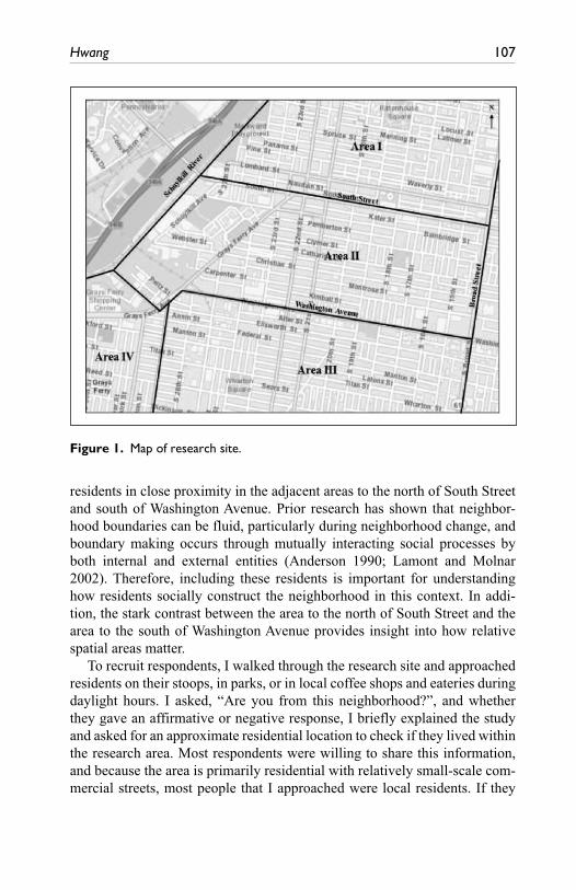
Figure 1 is a map depicting the research area. The numbered areas and bolded boundaries correspond to the aggregations of demographic and hous-ing data presented in Table 1. The data are divided into four areas based on “neighborhood statistical areas” defined by the Temple University Social Science Data Library. These areas are intended to be meaningful geographic units based on information collected from the major local newspaper, the police department, and historical research.
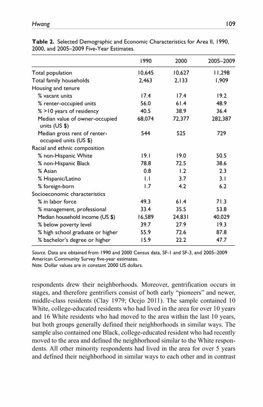
During my fieldwork, rapid gentrification was occurring in Area II of the map and is the primary focus of my study. As shown in Table 2, the area has experienced significant changes in its population composition and property values since 1990. Its share of non-Hispanic White and college-educated residents more than doubled and the share of Blacks reduced by nearly half. In addition, its median housing value increased by more than sixfold, which more than doubled the overall rate of increase for the entire city.
Research Design and Sample
To examine how residents socially construct the changing neighborhood, I conducted interviews and a mapping exercise with 56 residents, in which respondents drew maps of their neighborhood and surrounding adjacent areas. I supplemented the map and interview data with neighborhood obser-vations and archival resources.
I attempted to gather a sample of subjects who were equally distributed by race, education levels, and years of residency in the area and with some varia-tion along these dimensions to maximize the range of the sample. This strat-egy allows me to compare respondents along these social categories and to identify if a particular dimension was more salient than others (Weiss 1994). I also sought both respondents who lived within Area II (see Figure 1), where high levels of renovation and new construction were taking place, and
Hwang 107
residents in close proximity in the adjacent areas to the north of South Street and south of Washington Avenue. Prior research has shown that neighbor-hood boundaries can be fluid, particularly during neighborhood change, and boundary making occurs through mutually interacting social processes by both internal and external entities (Anderson 1990; Lamont and Molnar 2002). Therefore, including these residents is important for understanding how residents socially construct the neighborhood in this context. In addi-tion, the stark contrast between the area to the north of South Street and the area to the south of Washington Avenue provides insight into how relative spatial areas matter.
To recruit respondents, I walked through the research site and approached residents on their stoops, in parks, or in local coffee shops and eateries during daylight hours. I asked, “Are you from this neighborhood?”, and whether they gave an affirmative or negative response, I briefly explained the study and asked for an approximate residential location to check if they lived within the research area. Most respondents were willing to share this information, and because the area is primarily residential with relatively small-scale com-mercial streets, most people that I approached were local residents. If they
Figure 1. Map of research site.
108 Urban Affairs Review 52(1)
did live within the research area, I provided more details on the study and asked if they would be willing to participate. I offered a $5 gift card for local businesses as an incentive for participation. Respondents were disproportion-ately retired, self-employed, unemployed, full-time parents, or college or graduate students during the daytime hours and disproportionately full-time workers in the early evening hours.
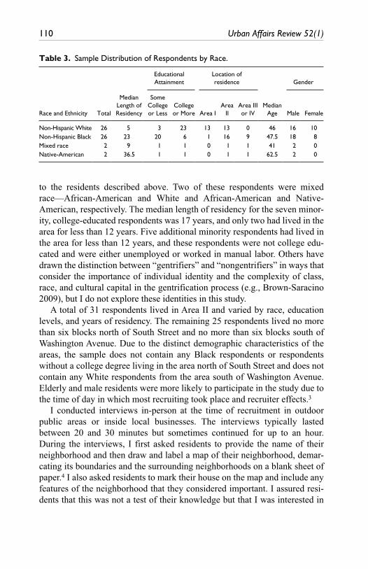
Table 3 displays descriptive information for my final sample of 56 respon-dents by race. I present the characteristics of respondents by race, rather than categorizing the respondents as “gentrifiers” and “nongentrifiers,” because as I will show in the results, race, rather than years of residency in the area or socioeconomic status, was the primary dimension that distinguished how
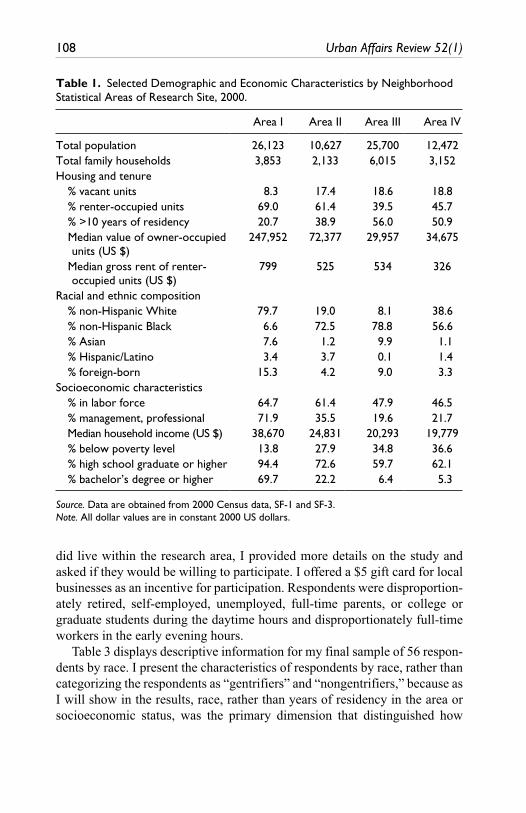
Table 1. Selected Demographic and Economic Characteristics by Neighborhood Statistical Areas of Research Site, 2000.
Area I Area II Area III Area IV
Total population 26,123 10,627 25,700 12,472Total family households 3,853 2,133 6,015 3,152Housing and tenure % vacant units 8.3 17.4 18.6 18.8 % renter-occupied units 69.0 61.4 39.5 45.7 % >10 years of residency 20.7 38.9 56.0 50.9 Median value of owner-occupied
units (US $)247,952 72,377 29,957 34,675
Median gross rent of renter-occupied units (US $)
799 525 534 326
Racial and ethnic composition % non-Hispanic White 79.7 19.0 8.1 38.6 % non-Hispanic Black 6.6 72.5 78.8 56.6 % Asian 7.6 1.2 9.9 1.1 % Hispanic/Latino 3.4 3.7 0.1 1.4 % foreign-born 15.3 4.2 9.0 3.3Socioeconomic characteristics % in labor force 64.7 61.4 47.9 46.5 % management, professional 71.9 35.5 19.6 21.7 Median household income (US $) 38,670 24,831 20,293 19,779 % below poverty level 13.8 27.9 34.8 36.6 % high school graduate or higher 94.4 72.6 59.7 62.1 % bachelor’s degree or higher 69.7 22.2 6.4 5.3
Source. Data are obtained from 2000 Census data, SF-1 and SF-3.Note. All dollar values are in constant 2000 US dollars.
Hwang 109
respondents drew their neighborhoods. Moreover, gentrification occurs in stages, and therefore gentrifiers consist of both early “pioneers” and newer, middle-class residents (Clay 1979; Ocejo 2011). The sample contained 10 White, college-educated residents who had lived in the area for over 10 years and 16 White residents who had moved to the area within the last 10 years, but both groups generally defined their neighborhoods in similar ways. The sample also contained one Black, college-educated resident who had recently moved to the area and defined the neighborhood similar to the White respon-dents. All other minority respondents had lived in the area for over 5 years and defined their neighborhood in similar ways to each other and in contrast
Table 2. Selected Demographic and Economic Characteristics for Area II, 1990, 2000, and 2005–2009 Five-Year Estimates.
1990 2000 2005–2009
Total population 10,645 10,627 11,298Total family households 2,463 2,133 1,909Housing and tenure % vacant units 17.4 17.4 19.2 % renter-occupied units 56.0 61.4 48.9 % >10 years of residency 40.5 38.9 36.4 Median value of owner-occupied
units (US $)68,074 72,377 282,387
Median gross rent of renter-occupied units (US $)
544 525 729
Racial and ethnic composition % non-Hispanic White 19.1 19.0 50.5 % non-Hispanic Black 78.8 72.5 38.6 % Asian 0.8 1.2 2.3 % Hispanic/Latino 1.1 3.7 3.1 % foreign-born 1.7 4.2 6.2Socioeconomic characteristics % in labor force 49.3 61.4 71.3 % management, professional 33.4 35.5 53.8 Median household income (US $) 16,589 24,831 40,029 % below poverty level 39.7 27.9 19.3 % high school graduate or higher 55.9 72.6 87.8 % bachelor’s degree or higher 15.9 22.2 47.7
Source. Data are obtained from 1990 and 2000 Census data, SF-1 and SF-3, and 2005–2009 American Community Survey five-year estimates.Note. Dollar values are in constant 2000 US dollars.
110 Urban Affairs Review 52(1)
to the residents described above. Two of these respondents were mixed race—African-American and White and African-American and Native-American, respectively. The median length of residency for the seven minor-ity, college-educated respondents was 17 years, and only two had lived in the area for less than 12 years. Five additional minority respondents had lived in the area for less than 12 years, and these respondents were not college edu-cated and were either unemployed or worked in manual labor. Others have drawn the distinction between “gentrifiers” and “nongentrifiers” in ways that consider the importance of individual identity and the complexity of class, race, and cultural capital in the gentrification process (e.g., Brown-Saracino 2009), but I do not explore these identities in this study.
A total of 31 respondents lived in Area II and varied by race, education levels, and years of residency. The remaining 25 respondents lived no more than six blocks north of South Street and no more than six blocks south of Washington Avenue. Due to the distinct demographic characteristics of the areas, the sample does not contain any Black respondents or respondents without a college degree living in the area north of South Street and does not contain any White respondents from the area south of Washington Avenue. Elderly and male residents were more likely to participate in the study due to the time of day in which most recruiting took place and recruiter effects.3
I conducted interviews in-person at the time of recruitment in outdoor public areas or inside local businesses. The interviews typically lasted between 20 and 30 minutes but sometimes continued for up to an hour. During the interviews, I first asked residents to provide the name of their neighborhood and then draw and label a map of their neighborhood, demar-cating its boundaries and the surrounding neighborhoods on a blank sheet of paper.4 I also asked residents to mark their house on the map and include any features of the neighborhood that they considered important. I assured resi-dents that this was not a test of their knowledge but that I was interested in
Table 3. Sample Distribution of Respondents by Race.
Race and Ethnicity Total
Median Length of Residency
Educational Attainment
Location of residence
Median Age
Gender
Some College or Less
College or More Area I
Area II
Area III or IV Male Female
Non-Hispanic White 26 5 3 23 13 13 0 46 16 10Non-Hispanic Black 26 23 20 6 1 16 9 47.5 18 8Mixed race 2 9 1 1 0 1 1 41 2 0Native-American 2 36.5 1 1 0 1 1 62.5 2 0
Hwang 111
how residents defined their neighborhood, and I included a sample map of fake neighborhoods to ease residents’ hesitation with the task.5
After residents drew their maps, I asked residents a series of questions on their sentiments of their neighborhood and its surrounding ones, their involve-ment in the neighborhood, its sense of community, and changes, if any, in these areas. The interview questions were intended to gain deeper insight into how residents gave meaning to their own neighborhoods and nearby neigh-borhoods. I directly asked residents about changes in their neighborhoods to elicit direct discussion of gentrification. The mapping activity and interview itself often provoked residents to reflect on the changing neighborhood iden-tity and its boundaries.
I analyzed the maps and interviews with particular attention to the names and boundaries that residents used to define their neighborhood and the sur-rounding ones. I assessed whether or not respondents’ neighborhood defini-tions were consistent with commonly used, or conventional, neighborhood boundaries—major streets, natural land barriers, administrative boundaries (e.g., police, school, or political districts), clear delineations by race or socio-economic status based on 2000 Census block group data, or central locations or landmarks.6 In addition, I used both the maps and interviews to determine the criteria that formed the basis for how residents defined their own neigh-borhoods relative to its adjacent neighborhoods and to identify themes that emerged in relation to how respondents defined their neighborhoods. Finally, I assessed whether these patterns and themes were related to each other in a systematic way, by respondents’ race, education levels, years of residency, or their residential location within the research area.
Results
In this section, I show that residents defined their neighborhoods in conflict-ing ways that sought to maintain or redefine the neighborhood identity and its boundaries. One group of respondents identified their neighborhood and its boundaries as a relatively large and inclusive geographic area using conven-tional boundaries and often referencing the area’s Black history. These were often direct responses to the exclusion and alienation they felt as the neigh-borhood changed. All of the respondents who defined their neighborhood in this way were Black or mixed-race but varied by education levels, length of residency, and location of residence within the research area. The remaining respondents identified their neighborhood and its boundaries based on socio-economic status and perceptions of crime, leading them to use unconven-tional boundaries that excluded areas from their neighborhoods that had higher shares of low-income minorities and devalued the area’s identity that
112 Urban Affairs Review 52(1)
minority respondents often used. Nearly all of the respondents who defined their neighborhoods this way were White. Below, I describe each type of socially constructed neighborhood. After describing the findings, I discuss the area today and the implications of these findings for understanding neigh-borhood change and inequality.
Reifying the Neighborhood by Inclusion
A total of 23 respondents, who were all minorities, named the neighborhood “South Philly,”7 which generally refers to a large region of the city, and 25 minority respondents used conventional neighborhood boundaries to identify their neighborhoods. Most defined their neighborhoods as large geographic areas, often using the name “South Philly,” and citing major streets and land-marks as its boundaries. They often referred to the character of South Philly directly in terms of race, particularly as a traditionally African-American area. One Black respondent stated, “If you walk down 16th Street, it’s ‘First Black’ . . . everything.” Respondents recognized that the “character” of the area was changing, but they overwhelmingly still referred to the area as South Philly. Steve, a 70-year-old, college-educated and longtime Black resident of Area II and part-time real estate developer, states, “It is no longer South Philly with its racial transition.” Having a rich African-American history, “South Philly,” therefore, held a racial meaning for many of these respondents.
Hearing others refer to the area with different names, several respondents insisted on preserving its South Philly name and often in resistance to the new identity that they felt was being imposed upon the area. James, a 57-year-old, noncollege-educated, Black resident who has lived in Area II his entire life, described this differentiation by neighborhood names as an unjust political process to displace long-term residents:
Where I live is still South Philly. The City Hall is doing the name changing . . . They are creating borders. It’s all politics, but it’s all still South Philly. They are just trying to push people out . . . They are trying to call it Center City, but it’s not. It’s South Philly.8
While some respondents, like James, attribute the changing identity, and the displacement that it may bring, to political actors, others blamed the gen-trifiers themselves.
Clyde, a 60-year-old, college-educated, Black resident who has lived in Area II his entire life and is now retired, explained how defining neighbor-hoods as smaller geographic areas, as nearly all of the White respondents in the sample did, was an act of intentional exclusion:
Hwang 113
We’re going to keep it old school. We’re not going to break it up into Graduate Square or anything and separate who’s in the ghetto and who’s not. There are 50 subtitles. South Philly is Queen Village, Southwark, Graduate/19th, Naval/Gray’s Ferry—it’s all a toss-up. You know, they changed the name of the Irish ghetto Devil’s Pocket to Gray’s Ferry. It’s all to take the stigmas away . . . but really, there’s no security. Everything is still there but dressed up.
Clyde draws on the authenticity—or “old school” character—to identify the neighborhood as South Philly, and he simultaneously criticizes the act of drawing smaller-sized exclusive neighborhoods and renaming them.
Several respondents who defined their neighborhood as large and inclu-sive areas expressed feelings of exclusion and alienation when describing the changing spatial area in relation to pressures of displacement. For example, Steve labeled the area south of Washington Avenue as “Where they displaced the Low Income Residents” instead of giving it a neighborhood name. Nicole, a Black, long-term resident of Area III and noncollege-educated homemaker, shares her feelings of unwelcome: “White people come in and make it better and want change . . . I hate to move but I have to . . . They just don’t want Blacks around.” Such feelings of exclusion were sometimes reflected in how respondents socially constructed their neighborhood, as they resisted changes in the identity and boundaries of the area. Moreover, some residents, like Nicole, felt that the exclusion had more to do with race than socioeconomic status. Nonetheless, in this area of Philadelphia, like in much of the United States, race and socioeconomic status overlap strongly, particularly when it comes to residential patterns (Massey and Denton 1993).
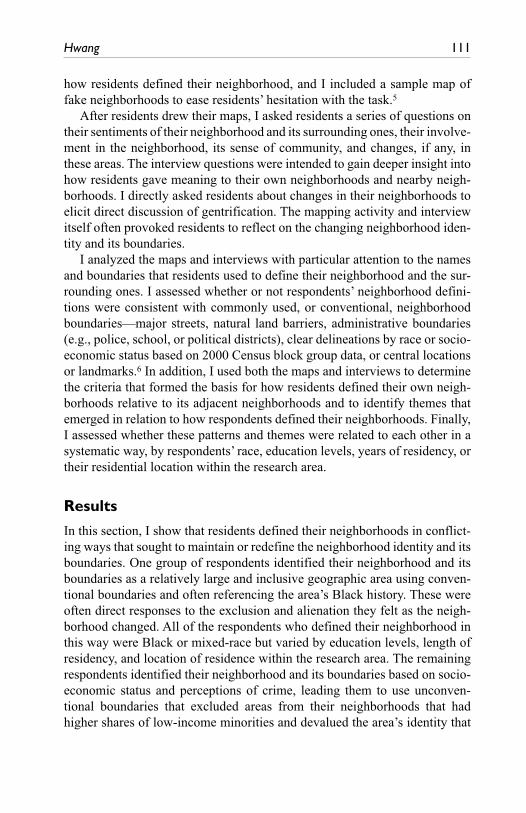
By defining their neighborhood based on its historical significance and not differentiating subsections of the area, these respondents drew their neigh-borhoods as very large geographic areas and used conventional boundaries. Alan, a 59-year-old Black, college-educated and longtime resident of Area II who is retired, exemplifies this pattern in his map shown in Figure 2. In his map, he depicts South Philly as a large regional area spanning from Market Street to the southern boundary of the city—Oregon Avenue.
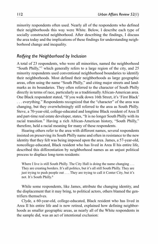
Many respondents, however, also referred to their neighborhood name as South Philly but drew their neighborhoods as a small number of blocks. James, mentioned earlier, illustrates this pattern in his map shown in Figure 3, in which he provides great detail at the localized level yet refers to his neighborhood as South Philly. Nearly all respondents who defined their neighborhood this way relied on local interactions to evaluate their own neighborhood. When I asked questions about whether they had things in common with others in their neigh-borhood, they discussed their proximal neighbors, but they referred to a large regional area to make comparisons with other neighborhoods. Because the larger regional areas of the city contain a wide range of demographic and
114 Urban Affairs Review 52(1)
Figure 2. Alan’s neighborhood definition. (A) Map drawn by Alan and (B) transformation of boundaries onto a map of this section of the city.
Figure 3. James’ neighborhood definition. (A) Map drawn by James and (B) transformation of boundaries onto a map of this section of the city.
Hwang 115
neighborhood quality characteristics and smaller areas of blocks are often quite similar to blocks nearby, these same respondents stated that crime and neighborhood changes were everywhere and not distinct to particular neigh-borhoods. When I asked James how his neighborhood compared with others by their sense of community, he replied, “I couldn’t say. They’re all just neigh-borhoods.” The limited upward residential and social mobility faced by many of the minority respondents constrains access to neighborhoods with a quality of life associated with higher socioeconomic status or low levels of crime (Massey and Denton 1993; Wilson 1987). Thus, the respondents did not dif-ferentiate neighborhoods by these characteristics.
Although several of the respondents frequently discussed concerns with crime and safety, only two nonwhite respondents, compared with 10 White respondents, defined their neighborhood boundaries in relation to crime and safety. Referring to the recent gunfire around Washington Avenue, Steve called Washington Avenue the “crack edge,” attributing the incident to the drug trade, and defined this as the southern boundary of the neighborhood. The other respondent, a 22-year-old, mixed-race (Black and non-Hispanic White) man, made this same observation and drew the southern boundary of the neighborhood one block north of Washington Avenue. Given that crime and disorder have disproportionately plagued low-income, Black communi-ties and have been in close proximity to middle-class, Black neighborhoods (Morenoff, Sampson, and Raudenbush 2001; Pattillo 1999), crime and disor-der may not serve as factors that differentiate neighborhoods for most minor-ity respondents. For some, differentiating neighborhoods by crime was an expression of racial biases. Bernard, a 60-year-old, college-educated, mixed-race (Black and Native-American) long-term resident and professional artist, remarked, “Crime is completely subjective . . . If there’s no Whites, then people think it’s higher, but people are just people.”
Overall, the overwhelming majority of minority respondents defined the neighborhood as a broad and inclusive spatial area, often in response to pres-sures of exclusion and drawing on the Black cultural history of the area to legiti-mate their presence. By defining their neighborhood in this way, they recognized exclusionary forces and often resisted such exclusion by reifying the preexisting identity of the changing space and relying on “strong” neighborhood boundar-ies. Moreover, they often did not differentiate the area into smaller neighbor-hoods, as they viewed these actions as a form of exclusion and inauthentic.
Redefining the Neighborhood by Exclusion
In contrast, many other respondents, who were mostly White, defined the neighborhood by differentiating it from where they perceived the socioeco-nomic status to be either lower or higher than their own or the crime to be
116 Urban Affairs Review 52(1)
higher. This led them to use a variety of names and boundaries to identify the neighborhood. These respondents, both new and long-term, used several dif-ferent names for the neighborhood—“Graduate Hospital,” “G-Ho,” “So-So,” “South Rittenhouse,” “South Square,” and “Southwest Center City,” and many mentioned how the name was changing. While many of them men-tioned “South Philly” as a name of the past or used it to describe the areas south of their defined neighborhood, none of them identified their neighbor-hood with this name. According to a historical database for the city’s neigh-borhoods and place names compiled in 1995, specified subneighborhoods within the “South Philly” area did exist but not one specific to the research site. However, the South of South Neighborhood Association was established in 1989, serving the area between Broad Street and the Schuylkill River and from South Street to Washington Avenue, but only a few residents used this name.
These respondents described a discrepancy between the character of the area and the South Philly identity in relation to their own personal identities. Diane, a White, college-educated resident of Area II for over 20 years and is a working professional, was uncertain about whether the area was “still” called “South Philly” and identifies her neighborhood as “Center City.” She explains, “Psychologically, I’m in Center City.” Christine, a 27-year-old, college-educated, White resident who has lived in Area II for two years and is a working professional, elaborates on this point: “Technically, this is South Philly, but I feel like I relate more to Center City. It’s a funny topic of conver-sation because the area is not really South Philly; hence the fuzzy name ‘Graduate Hospital.’” Christine’s remarks acknowledge that the “character” of the area does not fit with the meanings associated with “South Philly.” Yet, while Black respondents also recognized this change of character, they still identified their neighborhood as South Philly.
Twelve White respondents used the name “Graduate Hospital” to identify the area, while only one long-term, Black respondent—Steve, the part-time real estate developer mentioned earlier—did so. He explained that newcom-ers had recently added the name. Although this neighborhood name was non-existent, at least up to 1995 according to the historical database of city neighborhoods, the hospital, to which the name refers, has existed since the early 1900s and closed down in 2007. The hospital stands between 18th and 19th Streets, and straddles across Lombard, South, and Bainbridge Streets, but only two of the respondents using this name, who were long-term, White residents, described the hospital as a central location of their neighborhood. Most other respondents using this name did not draw the hospital on their maps, and for those who did, they drew it in the far corner of their neighbor-hoods. Moreover, neither of the two minority respondents living near the hospital mentioned it. Thus, while the long-term, White respondents used the
Hwang 117
name in reference to the area surrounding the actual hospital, the symbolic significance of the name reached beyond the building itself as a means for some residents, as well as realtors and developers, to differentiate the social identity of the area.
The ways in which respondents drew their neighborhood boundaries and further discussed these neighborhood distinctions reveal that these neighbor-hood names carry symbolic meaning tied to socioeconomic status and race. These respondents, however, often used a coded language distinguishing the new from the old and the safe from the unsafe, rather than directly discussing class and race. They stated that the boundaries were changing or uncertain, and as a result, they often used unconventional boundaries on their maps based on socioeconomic characteristics or their perceptions of crime and dis-order, rather than geographically fixed spatial areas. This strategy, conse-quently, included or excluded residents from their neighborhood definitions based on socioeconomic status or race.
John, a White working professional who has lived in Area II for five years, describes how he defines the neighborhood: “Every year, one more block is rehabbed and added to Graduate Hospital.” Thus, John considered housing renewal, which is inherently tied to the higher socioeconomic status of the residents who can afford these new houses, as a defining feature of his socially constructed neighborhood. However, while John differentiated his neighborhood from the older housing stock that characterized the area to the south, he also differentiated his neighborhood from the area to the north, stat-ing, “Rittenhouse is such a fancy neighborhood that everyone wants to say that they’re a part of it.” Indeed, some respondents differentiated their own neighborhoods from the area further south but made no distinction from the higher status area to the north.
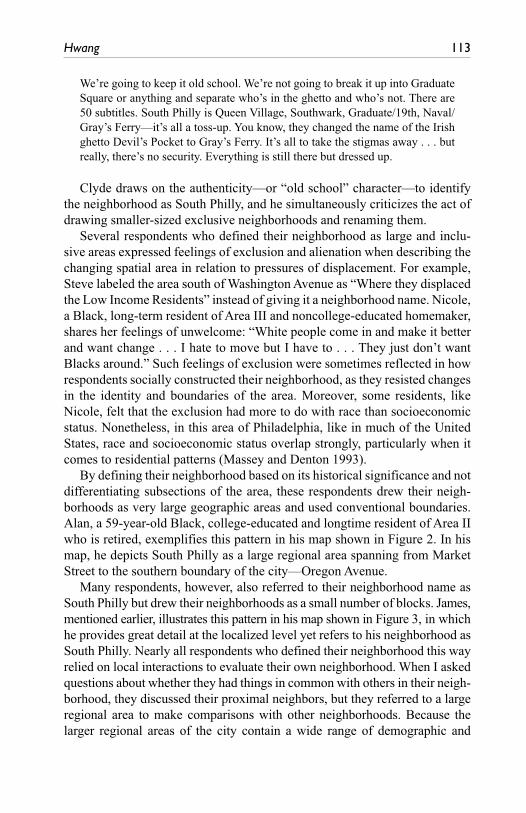
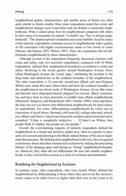
Figure 4 is a map drawn by Jeff—a White, 29-year-old, graduate student who has lived in Area II for a little over a year—and illustrates how respon-dents distinguished their neighborhoods based on socioeconomic status and perceived crime. Relatively new to the neighborhood and unfamiliar with the neighborhood name, Jeff delineated clear boundaries between what he identi-fies as his own neighborhood and the area south, which he described by the presence of prostitutes, drug dealers, and gunshots. Although he does not give a specific name for his own neighborhood, he labels the area as “Undefined blue-collar neighborhood.” Detailing the crack house and drug dealers on his own block, he still perceived his neighborhood to be below the status of the northern and eastern adjacent areas but above the status of the area to the south.
Many White respondents described how they did not walk in the area south of their defined neighborhoods for safety and comfort reasons and
118 Urban Affairs Review 52(1)
associated it with drugs and violence. Previous research on gentrifiers shows that they often seek out “gritty” or “risky” areas on the edges of “ghetto” neigh-borhoods (Anderson 1990; Clay 1979; Lloyd 2006). Jeff’s map depicts the common perception among this group of respondents that certain streets marked the frontier of crime and disorder and that areas further south were unsafe and plagued with drugs and violence, but the specific streets that marked this frontier varied between respondents. While violent crime and drug sales certainly did take place in the southern areas of the research site, this activity was often inconsistent with the boundaries that these respondents drew.
Several White respondents described how they lived “on the border” but always defined their own neighborhood as the area north of the border, which they perceived to be safer. Even residents who physically lived south of the “border” identified themselves as part of the area to the north of their north-ern neighborhood boundary. Paul, a 38-year-old, White, noncollege-educated resident of Area II who has lived in the area for five years and is a working professional, initially identified his neighborhood as “Center City” but drew his home south of the Center City boundary that he defined on his map and described the area south of Center City as “sketchy.” Despite his character-ization of the area around the actual physical location of his home, Paul pre-sented himself as a resident of the less “sketchy” area to the north.
Figure 4. Jeff’s neighborhood definition. (A) Map drawn by Jeff and (B) transformation of boundaries onto a map of this section of the city.
Hwang 119
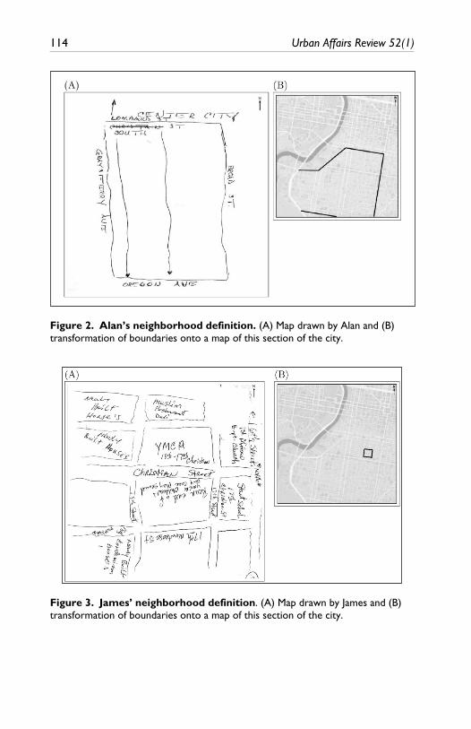
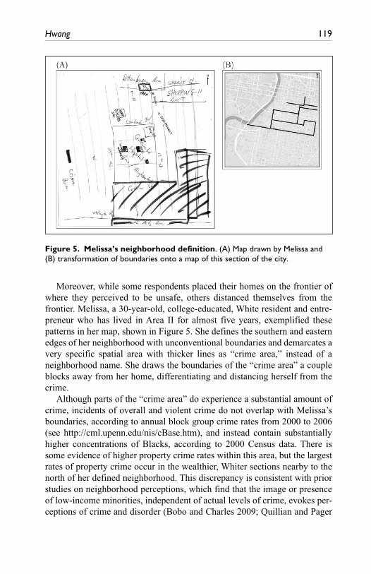
Moreover, while some respondents placed their homes on the frontier of where they perceived to be unsafe, others distanced themselves from the frontier. Melissa, a 30-year-old, college-educated, White resident and entre-preneur who has lived in Area II for almost five years, exemplified these patterns in her map, shown in Figure 5. She defines the southern and eastern edges of her neighborhood with unconventional boundaries and demarcates a very specific spatial area with thicker lines as “crime area,” instead of a neighborhood name. She draws the boundaries of the “crime area” a couple blocks away from her home, differentiating and distancing herself from the crime.
Although parts of the “crime area” do experience a substantial amount of crime, incidents of overall and violent crime do not overlap with Melissa’s boundaries, according to annual block group crime rates from 2000 to 2006 (see http://cml.upenn.edu/nis/cBase.htm), and instead contain substantially higher concentrations of Blacks, according to 2000 Census data. There is some evidence of higher property crime rates within this area, but the largest rates of property crime occur in the wealthier, Whiter sections nearby to the north of her defined neighborhood. This discrepancy is consistent with prior studies on neighborhood perceptions, which find that the image or presence of low-income minorities, independent of actual levels of crime, evokes per-ceptions of crime and disorder (Bobo and Charles 2009; Quillian and Pager
Figure 5. Melissa’s neighborhood definition. (A) Map drawn by Melissa and (B) transformation of boundaries onto a map of this section of the city.
120 Urban Affairs Review 52(1)
2001; Sampson 2009). With racial turnover as an integral part of the gentrifi-cation in the area, Whites’ perceptions of “unsafe” areas overlapped with where a substantial number of low-income, minority residents still resided. Unlike these respondents, minority respondents who discussed crime refer-enced specific gangs and drug territories, rather than feelings of discomfort and safety concerns.
Nonetheless, a few White respondents who had lived in the area for over 10 years expressed deep concern with the displacement of lower-income resi-dents and embraced the racial diversity of the neighborhood. Brown-Saracino (2009) referred to residents sharing this sentiment as social preservation-ists—those engaging in a “culturally motivated choice . . . to live in the cen-tral city . . . in order to live in authentic social space embodied by the sustained presence of ‘original’ residents” (p. 135). Despite their intentions and con-cerns, these residents did not identify the neighborhoods as large and inclu-sive areas using conventional boundaries. Most of these residents lived right around South Street and had long been part of this transitional area. Two of them referred to the area as “Graduate Hospital” and drew their neighbor-hood with the hospital as a central location and demarcated Bainbridge Street as the southern boundary. Diane, mentioned earlier, initially expressed uncer-tainty about what to call her neighborhood but writes “Center City/One block south of south” on her map, following the same strategies as the majority of White respondents. The last respondent who expressed concerns about the increasing homogeneity of the neighborhood lived a few blocks north of South Street and described the neighborhood as once being small but grow-ing due to the socioeconomic changes. Despite describing her neighborhood as a spatial area that is racially and ethnically mixed and mentioning the flu-idity of neighborhood boundaries, she identifies her neighborhood as “Center City” and names Lombard Street as the southern boundary of her neighbor-hood. She describes the area close to South Street as high in crime but consid-ers her socially constructed neighborhood to be safe.
In sum, many respondents identified their neighborhoods based on socio-economic status and perceptions of crime, and these respondents were pri-marily White but had lived in the area for varying lengths of time. The former dimension highlights class distinctions that these respondents drew between themselves and others in the area, and the latter appears to serve as a coded language for racial differences. Instead of defining the spatial area of their neighborhood based on conventional boundaries, such as major streets, these respondents viewed the spatial area of their neighborhood as a moving entity that shifted with the transformation of the area. Within this context of change, these residents socially constructed their neighborhoods as distinct from the area extending further south, which they associated with
Hwang 121
lower socioeconomic status and crime. Although these respondents may not have direct intentions to displace or alienate the area’s preexisting, minority residents and may be adopting such names and boundaries from external entities, such as real estate agents and peers, their neighborhood names and unconventional boundaries essentially exclude preexisting, minority resi-dents and devalue the “South Philly” identity. Many of the minority respon-dents, however, expressed that the emerging neighborhood identities and boundaries made many of them feel alienated and influenced the way in which they socially constructed their neighborhoods.
Discussion and Conclusion
The findings demonstrate how residents living in the same spatial area socially construct their neighborhood identity and spatial boundaries in con-flicting ways. Residents defined their neighborhoods along distinct dimen-sions to legitimize their presence in the neighborhood, and these differences varied primarily by the race of respondents in this context of gentrification. Nearly all minority respondents defined their neighborhood using conven-tional boundaries and as a large spatial area that encompassed various racial and socioeconomic groups and referenced the Black cultural history of the area. By doing so, these respondents reified a long-standing neighborhood identity, resisting exclusive social constructions of the neighborhood and asserting their right to the neighborhood space. White respondents, by con-trast, tended to define the neighborhood using a variety of names, unconven-tional boundaries, and intermediate-sized spatial areas that were based on socioeconomic status and perceptions of crime. Although perhaps uninten-tionally, these definitions excluded areas that tended to have lower incomes and higher shares of minorities and redefined the neighborhood area. White respondents’ intentions aside, minority respondents revealed that exclusion and alienation were real experiences for them.
Although the area is still commonly known for having multiple names, the area is often referred to as “Graduate Hospital” by major institutions and has continued to gentrify rapidly. In 2013, Philadelphia Magazine named it the “Hottest Philadelphia City Neighborhood” (Spikol 2013), and the most recent American Community Survey five-year estimates from 2008 to 2012 indicate that the share of Blacks has reduced by nearly 10 percentage points and the share of residents with college degrees has increased by nearly 15 percentage points since the 2005–2009 five-year estimates presented in Table 2. The area is now home to many local trendy bars, restaurants, and coffee shops.
Although local media sources on Philadelphia neighborhoods recognize many of the other names cited by the White respondents and identify the area
122 Urban Affairs Review 52(1)
with conventional boundaries, my findings reflect important dynamics from a point in time during which the neighborhood identity and boundaries were in flux. Most Whites defined the area as many things, except how minority respondents defined the area. Despite the fact that this section of the South Philadelphia area has been recognized by some as a subsection at least since 1989, when the South of South Neighborhood Association was established, White respondents used various names and boundaries to define the neigh-borhood, and minority residents resisted the newly defined neighborhood identity that was emerging and being recognized and legitimated by major institutions. Such an outcome illustrates how legitimizing a new neighbor-hood definition can dominate and alienate residents with less social, eco-nomic, and cultural capital.
Unlike previous work on neighborhood identity and boundaries, this study leverages a case of gentrification to contribute to understandings of how neighborhood definitions persist or change. The internal narratives of neigh-borhood identity and boundaries are not only embedded within a broader context of inequality but also shape how neighborhood identities and bound-aries remain the same or change. Existing evidence on neighborhood defini-tions find differences between respondents by race and socioeconomic status but predict that Whites and respondents with higher socioeconomic status are more likely to agree on neighborhood identities and boundaries. In this study, however, Black respondents of all education levels were far more likely to agree on the neighborhood identity and boundaries. The findings show that the lack of agreement and ambiguity in the neighborhood definition arise not from having lower socioeconomic status but, instead, depend on whether or not a group feels that they fit with the identity associated with a space and their strategies to exclude or include others to make the neighborhood iden-tity align with their personal identity. Thus, the context of inequality in which the social construction of neighborhoods is embedded matters for determin-ing consensus among a group.
In addition, the results illustrate greater complexity between short- and long-term residents. While familiarity with an area that comes with longer lengths of residency may play a role in how residents socially construct their neighborhoods, racial and socioeconomic differences dominate in this con-text of gentrification. Gentrification in recent decades is more often charac-terized by salient racial and class differences than in the past (Hackworth and Smith 2001), and these dimensions may distinguish residents more than length of residency in contemporary forms of gentrification.
This research also has methodological implications for the study of neigh-borhoods and cultural change. The cognitive maps and interviews capture a single point in the evolving gentrification process, but using this method at
Hwang 123
multiple points over time would provide a compelling account of cultural change as a neighborhood transforms. Furthermore, the findings engender questions on the neighborhood as a unit of analysis. Neighborhood studies often conceptualize the neighborhood unit as a static entity within which char-acteristics of the neighborhood can change, but this study demonstrates that the notion of the neighborhood is not a static spatial area but carries with it a host of symbolic meanings, such that the physical boundaries of the socially con-structed community can shift as the characteristics of a spatial context trans-form. For many respondents, the neighborhood boundaries moved with socioeconomic status and perceived crime. Although scholars have made con-siderable progress in defining neighborhoods in ways that are more consistent with the theoretical mechanisms by which neighborhoods affect its residents (e.g., Grannis 2009), this study contributes to this effort by demonstrating how subjective differences systematically vary in a context of neighborhood change.
These results also have broader implications for inequalities in racially and socioeconomically heterogeneous spaces. First, how residents define their neighborhoods can have tangible consequences for access to resources and opportunities. If institutions that serve as political resources legitimate some residents’ neighborhood definitions and their neighborhood member-ship and not others, some organizations may garner more resources than oth-ers when organizations associated with each defined neighborhood compete for limited resources. Moreover, some residents can be excluded from civic organizations associated with a neighborhood definition and a specific area’s interests. Studies have documented the political displacement that longtime residents experience in gentrification, such that newcomers create organiza-tions that better represent their own interests and steer political influence (Chernoff 1980; Fraser 2004; Hyra 2014). Nonetheless, Martin’s (2007) study of gentrifying neighborhoods in Atlanta demonstrates that in some con-ditions long-term residents are able to maintain their power and prevent such political displacement.
Second, defining a “new” neighborhood through distinguishing it from nearby areas can contribute to shaping which areas undergo reinvestment and which remain disinvested. Evidence shows the importance of neigh-borhood perceptions, in addition to race and class, in shaping the trajecto-ries of gentrifying neighborhoods (Hwang and Sampson 2014). If perceptions of neighborhoods are malleable, as the findings demonstrate, one section of a declined area can receive substantial economic benefits with a new identity and reputation, whereas another section may continue to be avoided.
Nevertheless, this study is not without limitations. This study was con-fined to a single area undergoing rapid gentrification in which Black–White
124 Urban Affairs Review 52(1)
differences were salient. Further research should explore how neighborhood definitions persist or change in gentrifying neighborhoods where the gentri-fiers and preexisting residents are largely the same racial or ethnic group, in neighborhoods that are undergoing racial but not socioeconomic changes, an increasingly common feature of neighborhoods impacted by immigrant growth, and in gentrifying neighborhoods where combinations of racial change beyond Black and White are occurring. In addition, the findings may reflect Philadelphia’s high levels of segregation and long history of racial strife, particularly between Blacks and Whites, and therefore, future work should explore if the same differences exist in other cities. Moreover, it is possible that residents respond to me, as the interviewer, in different ways. Being a distinct race from all of the respondents, my identity may have impacted the degree to which respondents explicitly or implicitly discussed race. Finally, while the maps and interviews demonstrate that respondents narrate their neighborhoods in conflicting ways, the data collected are lim-ited from a thick ethnographic and longitudinal account of the interactions and experiences that residents undergo, particularly with external forces, such as real estate agents, media, and developers, that shape how residents socially construct their neighborhoods. Further ethnographic research should explore these dynamics.
Despite limitations, this study sheds light on how residents socially con-struct their neighborhoods within the broader political economy. The study demonstrates a case in which residents with unequal economic, social, and cultural capital negotiate a neighborhood’s identity and boundaries. Although residents with more capital may not have negative intentions to exclude long-time, minority residents, the very practice of defining neighborhoods to reflect their identities shapes how they socially construct their neighbor-hoods, which ultimately excludes residents with less capital and devalues their socially constructed neighborhood. Nonetheless, gentrification can bring a multitude of benefits to neighborhoods that strongly need economic investment. As gentrification continues to expand and grow throughout cities in previously disinvested neighborhoods, leaders, institutions, and residents themselves should work to combat the social, cultural, political, and physical displacement of its preexisting residents so that its benefits can be shared among all of its residents.
Acknowledgment
I wish to thank Michael Rosenfeld, Doug McAdam, and Michael Kahan for their guidance on this project, and Monica Bell, Michèle Lamont, Jeremy Levine, Richard Ocejo, Ann Owens, and William Julius Wilson for helpful comments on earlier drafts of this article.
Hwang 125
Declaration of Conflicting Interests
The author(s) declared no potential conflicts of interest with respect to the research, authorship, and/or publication of this article.
Funding
The author(s) disclosed receipt of the following financial support for the research, authorship, and/or publication of this article: This research was supported in part by the National Science Foundation (NSF) Graduate Research Fellowship (Grant DGE-1144152), the NSF–Integrative Graduate Education and Research Traineeship (NSF-IGERT) Multidisciplinary Program in Inequality and Social Policy at Harvard University (Grant 0333403), and an Undergraduate Advising and Research (UAR) Major Grant from Stanford University.
Notes
1. The definition of gentrification is highly debated. Some areas of debate include whether it is restricted to inner cities or if displacement is inherent. For full reviews, see Lees, Slater, and Wyly (2008) and Brown-Saracino (2010).
2. I use real place names because pseudonyms require disguising characteristics of the site that are important for understanding the context about which the respon-dents speak, and the site is easily identifiable due to the mapping technique used in the study. I refer to all respondents by pseudonyms and remove identifying information in the figures presented.
3. Although space is limited for fully reflecting on my own biases and interviewer and recruiter effects, readers should note my role as a young, Asian-American female. Particularly in the residential areas that were homogeneously Black, my presence was very noticeable, attracting attention from most residents as an obvi-ous outsider to the neighborhood. Some residents shouted racial slurs at me, and several male respondents invited me on dates.
4. If residents’ maps were inconsistent with the name they provided (e.g., naming a large regional area of the city as their neighborhood but drawing a few blocks), I asked residents to verbally clarify the boundaries separating the neighborhood they named from surrounding neighborhoods.
5. Pilot interviews revealed some discomfort with the task. The sample map con-sisted of a rectangular area marked as “Neighborhood A” with the areas adjacent to the rectangle labeled as “Neighborhood B,” “Neighborhood C,” and so forth, and the boundaries of the rectangle labeled with fake names (e.g., Main Street). The sample map, which portrayed a neighborhood that conformed to my own conception of the structure of urban neighborhoods, did not limit the extent of variation in residents’ neighborhood definitions, even with regard to neighbor-hood size.
6. I developed a list of “natural” boundaries using several sources: rivers and major streets used to define neighborhoods by the Temple University Social Science Data Library; a historical database of the city’s neighborhoods and place names
126 Urban Affairs Review 52(1)
compiled from city archives; 2000 U.S. Census data on block group distributions of housing values, education levels, income, race and ethnicity, and family com-position; and political, school, and police boundaries obtained from city planning documents.
7. Respondents specifically refer to “South Philly” referencing the area west of Broad Street. Philadelphians also refer to the area east of Broad Street as “South Philly,” but this section carries distinct connotations from the area west of Broad Street.
8. City planning documents at the time do not include Area II in Center City.
References
Anderson, Elijah. 1990. Streetwise: Race, Class, and Change in an Urban Community. Chicago: Univ. of Chicago Press.
Bobo, Lawrence D., and Camille Z. Charles. 2009. “Race in the American Mind: From the Moynihan Report to the Obama Candidacy.” Annals of the American Academy of Political and Social Science 621:243–59.
Brown-Saracino, Japonica, ed. 2010. The Gentrification Debates. New York: Routledge.
Brown-Saracino, Japonica. 2009. A Neighborhood that Never Changes: Gentrification, Social Preservation, and the Search for Authenticity. Chicago: Univ. of Chicago Press.
Campbell, Elizabeth, Julia R. Henly, Delbert S. Elliott, and Katherine Irwin. 2009. “Subjective Constructions of Neighborhood Boundaries: Lessons from a Qualitative Study of Four Neighborhoods.” Journal of Urban Affairs 31 (4): 461–90.
Centner, Ryan. 2008. “Place of Privileged Consumption Practices: Spatial Capital, the Dot-com Habitus, and San Francisco’s Internet Boom.” City and Community 7 (3): 193–223.
Chamberlain, Lisa. 2006. “Tax Breaks Drive a Philadelphia Boom.” The New York Times, January 8. Retrived from http://www.nytimes.com/2006/01/08/realestate/08nati.html?pagewanted=all &_r=0
Chaskin, Robert J. 1997. “Perspectives on Neighborhood and Community: A Review of the Literature.” Social Service Review 71 (4): 521–47.
Chernoff, Michael. 1980. “Social Displacement in a Renovating Neighborhood’s Commercial District.” In Back to the City: Issues in Neighborhood Renovation, edited by Shirley Bradway Laska and Daphne Spain, 204–18. New York: Pergamon Press.
Clay, Phillip L. 1979. Neighborhood Renewal. Lexington, MA: Lexington Books.Coulton, Claudia J., Jill Korbin, Tsui Chan, and Marilyn Su. 2001. “Mapping
Residents’ Perceptions of Neighborhood Boundaries: A Methodological Note.” American Journal of Community Psychology 29 (2): 371–83.
Deener, Andrew. 2007. Venice: A Contested Bohemia in Los Angeles. Chicago: Univ. of Chicago Press.
Fraser, James C. 2004. “Beyond Gentrification: Mobilizing Communities and Claiming Space.” Urban Geography 25 (5): 437–57.
Hwang 127
Grannis, Rick. 2009. From the Ground Up: Translating Geography into Community Through Neighbor Networks. Princeton: Princeton Univ. Press.
Guest, Avery M., and Barrett A. Lee. 1984. “How Urbanites Define Their Neighborhoods.” Population and Environment 7 (1): 32–56.
Hackworth, Jacob, and Neil Smith. 2001. “The Changing State of Gentrification.” Tijdschrift voor Economische en Sociale Geografie 92 (4): 464–77.
Hunter, Albert. 1974. Symbolic Communities: The Persistence and Change of Chicago’s Local Communities. Chicago: Univ. of Chicago Press.
Hunter, Marcus Anthony. 2013. Black Citymakers: How the Philadelphia Negro Changed Urban America. London: Oxford Univ. Press.
Hwang, Jackelyn, and Robert J. Sampson. 2014. “Divergent Pathways of Gentrification: Racial Inequality and the Social Order of Renewal in Chicago Neighborhoods.” American Sociological Review 79 (4): 726–51.
Hyra, Derek. 2014. “The Back-to-the-City Movement: Neighbourhood Redevelopment and Processes of Political and Cultural Displacement.” Urban Studies. Published electronically July 18. doi:10.1177/0042098014539403.
Lamont, Michèle, and Virag Molnar. 2002. “The Study of Boundaries in the Social Sciences.” Annual Review of Sociology 28:167–95.
Lees, Loretta, Tom Slater, and Elvin Wyly. 2008. Gentrification. New York: Routledge.Lloyd, Richard. 2006. Neo-Bohemia: Art and Commerce in the Post-industrial City.
New York: Routledge.Logan, John R., and Harvey L. Molotch. 1987. Urban Fortunes: The Political
Economy of Place. Berkeley: Univ. of California Press.Martin, Leslie. 2007. “Fighting for Control: Political Displacement in Atlanta’s
Gentrifying Neighborhoods.” Urban Affairs Review 42 (5): 603–28.Martin, Leslie. 2008. “Boredom, Drugs, and Schools: Protecting Children in
Gentrifying Communities.” City & Community 7 (4): 331–46.Massey, Douglas S., and Nancy A. Denton. 1993. American Apartheid: Segregation
and the Making of the Underclass. Cambridge: Harvard Univ. Press.Morenoff, John D., Robert J. Sampson, and Stephen W. Raudenbush. 2001.
“Neighborhood Inequality, Collective Efficacy, and the Spatial Dynamics of Urban Violence.” Criminology 39 (3): 517–59.
Ocejo, Richard E. 2011. “The Early Gentrifier: Weaving a Nostalgia Narrative on the Lower East Side.” City & Community 10 (3): 285–310.
Orleans, Peter. 1973. “Differential Cognition of Urban Residents: Effects of Social Scale on Mapping.” In Image and Environment: Cognitive Mapping and Spatial Behavior, edited by Roger M. Downs and David Stea, 115–30. Chicago: Aldine.
Park, Robert E., Ernest W. Burgess, and Roderick D. McKenzie. 1925. The City. Chicago: The Univ. of Chicago Press.
Pattillo, Mary E. 1999. Black Picket Fences: Privilege and Peril Among the Black Middle Class. Chicago: Univ. of Chicago Press.
Pattillo, Mary E. 2003. “Negotiating Blackness, for Richer or for Poorer.” Ethnography 4 (1): 61–93.
128 Urban Affairs Review 52(1)
Quillian, Lincoln, and Devah Pager. 2001. “Black Neighbors, Higher Crime? The Role of Racial Stereotypes in Evaluations of Neighborhood Crime.” American Journal of Sociology 107 (3): 717–67.
Sampson, Robert J. 2009. “Disparity and Diversity in the Contemporary City: Social (Dis)Order Revisited.” British Journal of Sociology 60 (1): 1–31.
Sampson, Robert J. 2012. Great American City: Chicago and the Enduring Neighborhood Effect. Chicago: Univ. of Chicago Press.
Sastry, Narayan, Ann R. Pebley, and Michela Zonta. 2002. “Neighborhood Definitions and the Spatial Dimension of Daily Life in Los Angeles.” Working Paper No. 033-04, California Center for Population Research, University of California-Los Angeles. https://escholarship.org/uc/item/7vx1j291. (Accessed December 5, 2009).
Smith, Neil. 1998. “Gentrification.” In The Encyclopedia of Housing, edited by Willem Van Vliet–, 198–99. London: Taylor & Francis.
Spikol, Liz. 2013. “Hottest Philadelphia City Neighborhoods: Let’s Start with Graduate Hospital.” Philadelphia Magazine, March 29. Retrieved from http://www.philly-mag.com/property/2013/03/29/hottest-philadelphia-city-neighborhoods-lets-start-with-graduate-hospital/
Suttles, Gerald D. 1972. The Social Construction of Communities. Chicago: Univ. of Chicago Press.
Tissot, Silvie. 2011. “Of Dogs and Men: The Making of Spatial Boundaries in a Gentrifying Neighborhood.” City & Community 10 (3): 265–84.
Weiss, Robert S. 1994. Learning from Strangers: The Art and Method of Qualitative Interview Studies. New York: Free Press.
Wilson, William J. 1987. The Truly Disadvantaged: The Inner City, the Underclass, and Public Policy. Chicago: Univ. of Chicago Press.
Zukin, Sharon. 1995. The Culture of Cities. Oxford: Blackwell.
Author Biography
Jackelyn Hwang is a PhD candidate in Sociology and Social Policy at Harvard University and a Doctoral Fellow in the Multidisciplinary Program in Inequality and Social Policy. Her research interests include urban sociology, race and ethnicity, immigration, and inequality. Her projects examine how racial and ethnic inequality influences and is influenced by gentrification and the housing crisis in US cities.