THE ROLE OF MANTLE-ROOTED LATITUDINAL STRUCTURES IN …2).pdf · THE ROLE OF MANTLE-ROOTED...
28
THE ROLE OF MANTLE-ROOTED LATITUDINAL STRUCTURES IN GLOBAL METALLOGENY AND THEIR POTENTIAL TO CONTROL STRONG EARTHQUAKES JAN KUTINA Laboratory of Global Tectonics and Metallogeny c/o Department of Chemistry, American University Washington, D.C. 20016-8014, U.S.A. Le rôle des structures latitudinales enracinées dans le manteau pour la métallogénie globale et leur potentiel de controller les forts tremblements de terre. L’auteur presente l’expérience acquise grace aux études entreprises sur les structures latitudinales enracinées dans le manteau dans l’hémisphère septentrionale et essaie de definir leur rôle dans la région carpathique de la Roumanie et les aires adjacentes. On a utilisé la nouvelle carte méttalogénique de l’Europe centrale et sud-estique – un extrait de GIS Europe, le raport BRGM (Cassard et al., 2006) et la carte du relief de la même zone avec la zone Tornqvist-Teisseyre (TTZ) superposée, pour demontrer que l’Orogen carpathique a été surveillé sur le territoire de la Roumanie et ses aires adjacentes à l’aide de l’action combinée des structures majeures latitudinales (1), de deux corps lithospheriques (la Plate-forme Moesienne et le Basin Transylvain) (2) qui ont survecu à l’orogenèse, et la zone Tornqvist-Teisseyre qui s’etend sur la direction NO. Key words : global metalogeny, latitudinal structures. 1. INTRODUCTION In 1973 I was invited to the IAVCEI Symposium on Volcanism and Associated Metallogenesis held in Bucharest to present results from my studies of structural control of endogenic ore deposits on four continents (Kutina, 1974). Since then, I have used different geophysical methods, especially the residual and regional Bouguer gravity anomaly maps with different wavelength filtering as introduced by Hildenbrand et al. (1982), as well as magnetic anomaly maps and seismic data to reveal deep structures of the lithosphere. This helped to define some of the structures controlling the ascent of heat, magmas and ore-forming fluids into * Cartography: Walter J. Bawiec and Paul Schruben, U.S. Geological Survey. Rev. Roum. GÉOPHYSIQUE, 50, p. 3–30, 2006, Bucureşti
Transcript of THE ROLE OF MANTLE-ROOTED LATITUDINAL STRUCTURES IN …2).pdf · THE ROLE OF MANTLE-ROOTED...
THE ROLE OF MANTLE-ROOTED LATITUDINAL STRUCTURES IN GLOBAL METALLOGENY
AND THEIR POTENTIAL TO CONTROL STRONG EARTHQUAKES
JAN KUTINA
Laboratory of Global Tectonics and Metallogeny c/o Department of Chemistry, American University
Washington, D.C. 20016-8014, U.S.A.
Le rôle des structures latitudinales enracinées dans le manteau pour la métallogénie globale et leur potentiel de controller les forts tremblements de terre. L’auteur presente l’expérience acquise grace aux études entreprises sur les structures latitudinales enracinées dans le manteau dans l’hémisphère septentrionale et essaie de definir leur rôle dans la région carpathique de la Roumanie et les aires adjacentes. On a utilisé la nouvelle carte méttalogénique de l’Europe centrale et sud-estique – un extrait de GIS Europe, le raport BRGM (Cassard et al., 2006) et la carte du relief de la même zone avec la zone Tornqvist-Teisseyre (TTZ) superposée, pour demontrer que l’Orogen carpathique a été surveillé sur le territoire de la Roumanie et ses aires adjacentes à l’aide de l’action combinée des structures majeures latitudinales (1), de deux corps lithospheriques (la Plate-forme Moesienne et le Basin Transylvain) (2) qui ont survecu à l’orogenèse, et la zone Tornqvist-Teisseyre qui s’etend sur la direction NO.
Key words : global metalogeny, latitudinal structures.
1. INTRODUCTION
In 1973 I was invited to the IAVCEI Symposium on Volcanism and Associated Metallogenesis held in Bucharest to present results from my studies of structural control of endogenic ore deposits on four continents (Kutina, 1974). Since then, I have used different geophysical methods, especially the residual and regional Bouguer gravity anomaly maps with different wavelength filtering as introduced by Hildenbrand et al. (1982), as well as magnetic anomaly maps and seismic data to reveal deep structures of the lithosphere. This helped to define some of the structures controlling the ascent of heat, magmas and ore-forming fluids into * Cartography: Walter J. Bawiec and Paul Schruben, U.S. Geological Survey.
Rev. Roum. GÉOPHYSIQUE, 50, p. 3–30, 2006, Bucureşti
Jan Kutina 2
4
the upper crust, crucial for large concentration of metals (Kutina, 1986a, 1988a, 1991; Kutina & Hildenbrand, 1987, and other papers). Most recently I started to compare the deep-seated structures controlling the location of giant ore deposits and ore clusters of endogenic origin with structures upon which some strong and destructive earthquakes such as the July 1976 Tangshan earthquake in north-eastern China (with a death toll of more than 200,000 people) occur. The initial results, jointly presented with my Chinese colleagues (Kutina et al., 2006) show that (1) both the giant ore deposits and the strong destructive earthquakes which we have used for comparison, occurred on mantle-rooted structures, and that (2) strong earthquakes also occurred during the multi-stage and polyascendent formation of giant ore deposits, reflected by volcanism, displacement along faults, reopening of faults, brecciation and other features. The igneous rocks have apparently “sealed” the deep-seated channel ways which guided the ascent of magmas and made these places less vulnerable to recent earthquakes. This observation is in line with that by Khamrabaev et al. (1988, 1999) who noticed a certain antagonism between the location of recent major earthquakes and major metallic deposits in Central Asia.
The above observations under (1) and (2) may initiate a broader study aimed at elaboration of criteria defining mantle-rooted structures which are vulnerable to earthquakes, including areas where the present regional stress distribution does not pose an immediate danger. A particular area suitable for a case study appears in the broad east-west belt in the southern parts of the Eurasian plate which was subjected to Mesozoic and Cenozoic tectonic and metallogenic events. This belt, with the Alpine and Carpathian systems to the west and the Yinshan-Tianshan EW belt of China to the east, and possible eastern extension across the Korean Peninsula and the Sea of Japan should be studied in the context of interaction with the African and Arabian plates to the south and the deep lithospheric structure of the central and northern parts of Europe and Asia to the north.
My sincere thanks are due to Prof. Angela Crăciun, President of Organisation Mondiale de Mineralogie who supports development of new ideas and has initiated my invitation to Romania. I am grateful to Professor Dorel Zugrăvescu, Director of the “Sabba S. Ştefănescu” Institute of Geodynamics of the Romanian Academy, for providing me with an opportunity to present my ideas at the International Scientific Seminar “The dynamics of the earth’s crust; implications in geodynamics – earthquakes and genesis of mineral resources” on March 23, 2006. I greatly appreciated this opportunity to appear before the audience of Romanian geologists and seismologists who have done an enormous amount of detailed studies in a region of crucial geotectonic importance where the Carpathian orogen bends in front of the Tornqvist Line.
I apologize for my yet insufficient knowledge of the extensive literature on Romania. Therefore some of my observations may already be known by my Romanian colleagues. Any corrections and comments on my ideas are appreciated.
3 The role of mantle-rooted latitudinal structures
5
2. EXPERIENCE FROM GLOBAL STUDIES OF STRUCTURAL CONTROLS OF MAJOR CONCENTRATIONS OF METALS OF ENDOGENIC ORIGIN
Before applying my approach to the Carpathian region of Romania and setting it in the context of a broader region, I will briefly review some of the experience from my previous studies.
The United States, extending “coast to coast” along the latitudes, provided an excellent opportunity to investigate some basic questions. One of them relates to the latitudinal fracture zones: Are the east-west trending fracture zones of the continental United States related to the east-west fracture zones of the East Pacific floor and the Atlantic Ocean floor?
The initial observations by Fuller (1964) and Affleck (1970) showed interruptions of magnetic anomalies at corresponding latitudes indicating continental extension of the east-west trending fracture zones across the United States. Kutina (1980, 1991), focusing on a belt of latitudes close to 40oN, presented criteria indicating a major EW-trending. mantle-rooted structural discontinuity extending across the entire western United States, at a latitude comparable to the Mendocino fracture zone in the East Pacific floor. The criteria were based on examination of global magnetic and gravity maps, long-wavelength and short wavelength Bouguer gravity anomaly maps, isostatic anomaly maps, magnetic anomaly patterns on the scale of the western United States, contour maps of seismic Pn velocities, seismotectonic studies, heat flow patterns, morphostructural criteria, patterns in the distribution of magmatic rocks, and boundaries based on isotopic data.
Using published data on different parts of the country, including the 38th Parallel Lineament of Heyl (1972), a map of the main latitudinal structures of the United States has been compiled (the latest version in Kutina, 1995, with references, also in Kutina et al., 2006, Fig. 1). These EW-structural discontinuities are not continuously expressed in the surface geology of the United States, but geophysical data show their existence. Their presence is reflected, in particular, at intersections with deep-seated structures of other trends which provided favorable structural conditions for the ascent of magmas and associated mineralization. As a consequence, we get a pattern of major ore clusters along one and the same latitudinal mantle-rooted discontinuity, separated by segments with a low concentration of metals. This feature essentially corresponds to the “ore-concentrating structures” of Russian authors (e.g., Favorskaya & Tomson, ed. 1974), also referred to as metallotect-potential zones (Kutina, 2006)∗.
∗ In some cases a long segment of an “ore-concentrating structure” is quite continuously mineralized, e.g., in the “Zhitomir sub-zone” in the Ukraine (see later in this paper).
Jan Kutina 4
6
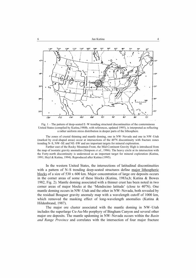
Fig. 1 – The pattern of deep-seated E–W trending structural discontinuities of the conterminous
United States (compiled by Kutina,1988b, with references, updated 1995), is interpreted as reflecting a rather uniform stress distribution in deeper parts of the lithosphere.
The zones of crustal thinning and mantle doming, one in NW–Nevada and one in NW–Utah (marked by oval-shaped areas) occur at intersections of the 40oN discontinuity with fracture zones trending N–S, NW–SE and NE–SW and are important targets for mineral exploration.
Farther east of the Rocky Mountain Front, the Mid-Continent Gravity High is introduced from the map of isostatic gravity anomalies (Simpson et al., 1986). The heavy circle at its intersection with the Forty-north discontinuity is understood as an important target for mineral exploration (Kutina, 1991; Heyl & Kutina, 1994). Reproduced after Kutina (1995).
In the western United States, the intersections of latitudinal discontinuities with a pattern of N–S trending deep-seated structures define major lithospheric blocks of a size of 530 x 600 km. Major concentration of large ore deposits occurs in the corner areas of some of these blocks (Kutina, 1983a,b; Kutina & Bowes 1982, Fig. 2). Mantle doming associated with a thinner crust has been noted in two corner areas of major blocks at the ‘Mendocino latitude’ (close to 40oN). One mantle doming occurs in NW–Utah and the other in NW–Nevada, both revealed by the residual Bouguer gravity anomaly map with a wavelength cutoff of 1000 km, which removed the masking effect of long-wavelength anomalies (Kutina & Hildenbrand, 1987).
The major ore cluster associated with the mantle doming in NW–Utah includes the superlarge Cu-Au-Mo porphyry of Bingham Canyon and several other major ore deposits. The mantle updoming in NW–Nevada occurs within the Basin and Range Province and correlates with the intersection of four major fracture
5 The role of mantle-rooted latitudinal structures
7
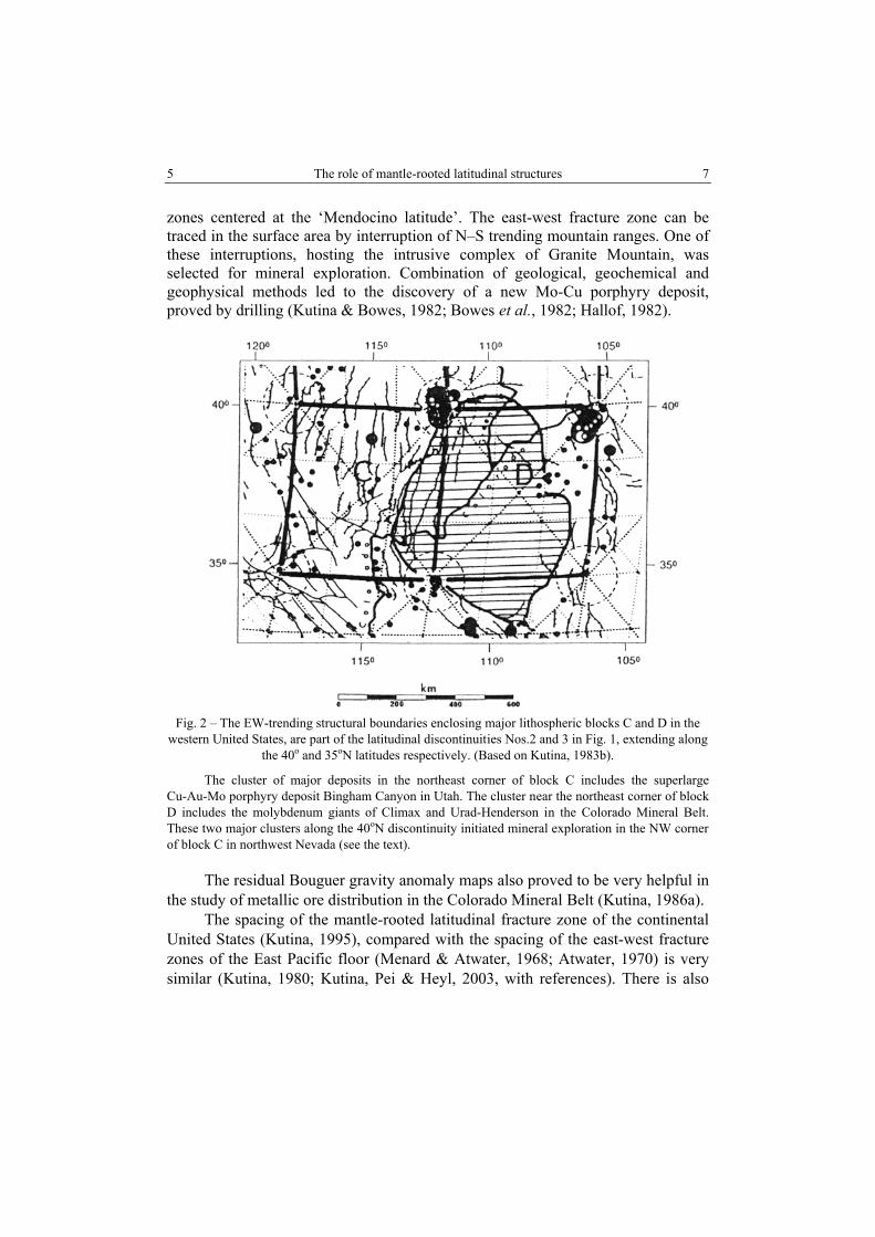
zones centered at the ‘Mendocino latitude’. The east-west fracture zone can be traced in the surface area by interruption of N–S trending mountain ranges. One of these interruptions, hosting the intrusive complex of Granite Mountain, was selected for mineral exploration. Combination of geological, geochemical and geophysical methods led to the discovery of a new Mo-Cu porphyry deposit, proved by drilling (Kutina & Bowes, 1982; Bowes et al., 1982; Hallof, 1982).
Fig. 2 – The EW-trending structural boundaries enclosing major lithospheric blocks C and D in the
western United States, are part of the latitudinal discontinuities Nos.2 and 3 in Fig. 1, extending along the 40o and 35oN latitudes respectively. (Based on Kutina, 1983b).
The cluster of major deposits in the northeast corner of block C includes the superlarge Cu-Au-Mo porphyry deposit Bingham Canyon in Utah. The cluster near the northeast corner of block D includes the molybdenum giants of Climax and Urad-Henderson in the Colorado Mineral Belt. These two major clusters along the 40oN discontinuity initiated mineral exploration in the NW corner of block C in northwest Nevada (see the text).
The residual Bouguer gravity anomaly maps also proved to be very helpful in the study of metallic ore distribution in the Colorado Mineral Belt (Kutina, 1986a).
The spacing of the mantle-rooted latitudinal fracture zone of the continental United States (Kutina, 1995), compared with the spacing of the east-west fracture zones of the East Pacific floor (Menard & Atwater, 1968; Atwater, 1970) is very similar (Kutina, 1980; Kutina, Pei & Heyl, 2003, with references). There is also
Jan Kutina 6
8
similarity with the east-west fracture zones of the Atlantic Ocean floor, usually interpreted as transform faults (Kutina & Norton, 1978).
It is very interesting that the spacing between the three major latitudinal systems of China (Institute of Geomechanics, Chinese Academy of Geological Science, 1978) is very similar to the spacing between the mantle-rooted latitudinal structures of the United States (Kutina, 1983a,b). The size of the Ordos block, enclosed between the Yinshan-Tianshan EW belt and the Tsinling-Kunlun EW-belt of China corresponds to the size of the lithospheric blocks enclosed between the latitudinal structures in the western United States (Kutina, 1983b, 1986b).
A question arises: What is the cause of the above noticed similarity in the spacing between the latitudinal fracture zones in regions so distant as the United States and China? Let us evaluate some of the observations and use them in building up a working hypothesis:
1. Fracture patterns are, in general, related to stress distribution. Varnes (1962) using field data from the San Juan Mts. in Colorado, demonstrated mathematical derivation of fracture trajectories – theoretical positions of fractures and compared them with actual fractures and ore veins. In a paper, reviewed by David Varnes, I showed that fracture trajectories can also be derived empirically, based on the strike of faults and on regularity in their spacing – the latter being either equidistant – or gradually greater or smaller in a certain direction (Kutina et al., 1967).
2. The pattern of mantle-rooted latitudinal fractures of the United States (Fig. 1) reflects a quite uniform stress distribution at the time of their origin. When projected over the pattern of ‘modern stress field provinces’ of the United States as compiled by Zoback & Zoback (1980), the latitudinal fractures extend across the boundaries of the stress field provinces (Kutina, 1988b; Kutina, Pei & Heyl, 2003).
3. The pattern of east-west fracture zones of the East Pacific floor as shown by Menard & Atwater (1968) and Atwater (1980), is a typical case of equidistant distribution of fractures originated under a uniform stress distribution over vast areas. These fracture zones, extending into the young oceanic crust, give the impression of being young features, supported by the young age of volcanic rocks.
However, the spacing of the oceanic fracture zones correlates with the spacing of the mantle-rooted latitudinal discontinuities of the continental United States.
The following working hypothesis is offered: The similar spacing between the latitudinal fracture zones or structural
discontinuities as observed (1) in the East Pacific Ocean floor,(2) in the continental United States (mantle-rooted EW-structures), (3) in the Atlantic Ocean floor, and (4) in the latitudinal tectonic systems that extend across the whole territory of China, indicate that these similarities are caused by a global force which gave rise to global fracturing before separation of the present continental and oceanic areas. My tentative interpretation is that the pattern of east-west fracture zones in the

7 The role of mantle-rooted latitudinal structures
9
present-day oceanic areas reflects latitudinal fractures in the upper mantle which propagated upwards through the oceanic crust. Several authors ascribed the global fracturing including the origin of latitudinal fracture zones, to changes in stress distribution connected with the changes in the speed of the Earth’s rotation: Stovas (1963a, b); Stovickova (1966), Sun Dianqing & Gao Qinghua (1980), and others. The global magnetic anomaly maps based on satellite measurements, as introduced by Regan et al. (1975) and Langel et al. (1982), have revealed major belts of magnetic highs and lows extending for as much as thousands of kilometers through the lithosphere. Kutina & Taylor (2003), examining the changes of magnetic amplitude of these belts concluded the belts can be used as markers in the geological evolution. For instance, the Proterozoic age of the granitic rocks and associated tin deposits which intruded along a fracture zone extending transversely to an east-west belt in the state of Rondonia in western Brazil, show that this east-west belt defined by satellite magnetometry had to exist there in the lithosphere as early as in the Proterozoic, possibly even in the Archean.
If, according to the plate tectonic concept, a major continental mass breaks down by a rift zone into two parts (lithospheric plates) which move away from each other, then the pattern of mantle-rooted structural discontinuities of each of the plates can change orientation with regard to the geographic coordinates. Using the separation of South America from Africa according to the model of Sclater & McKenzie (1973), the major NW-trending fracture zones of present day South America should have in the ‘pre-drift’ position, an east-west orientation (Kutina et al., 1978). The importance of the NW-fracture zones of present day South America in concentration of metals has been shown by Richards (2001). Nevertheless, some latitudinal structures can be traced across the South American continent and are reflected in the western, convergent margin of the plate (Kutina, 1993, unpubl. report).
3. MAJOR LATITUDINAL STRUCTURES AND LITHOSPHERIC BLOCKS IN THE CARPATHIANS ON ROMANIAN TERRITORY, SET IN THE CONTEXT OF MAJOR
EAST-WEST STRUCTURES OF EUROPE
3.1. LATITUDINAL STRUCTURES IN CENTRAL AND NORTHERN EUROPE
Figure 3, compiled by Kutina (1999), first reproduced in this paper, shows the following EW-structures in the central and northern parts of Europe (counting from the north):
1. North Danish Basin, after P.A. Ziegler (1982), extending east-west along axis A for about 700 km.
2. North German Basin, after P.A. Ziegler (1982), extending along axis B for about 1,300 km.
Jan Kutina 8
10
3. An east-west gravity lineament, the ‘Norddeutsche Linie’ defined by Bachmann & Grosse (1989), shown by axis D south of the North German Basin.
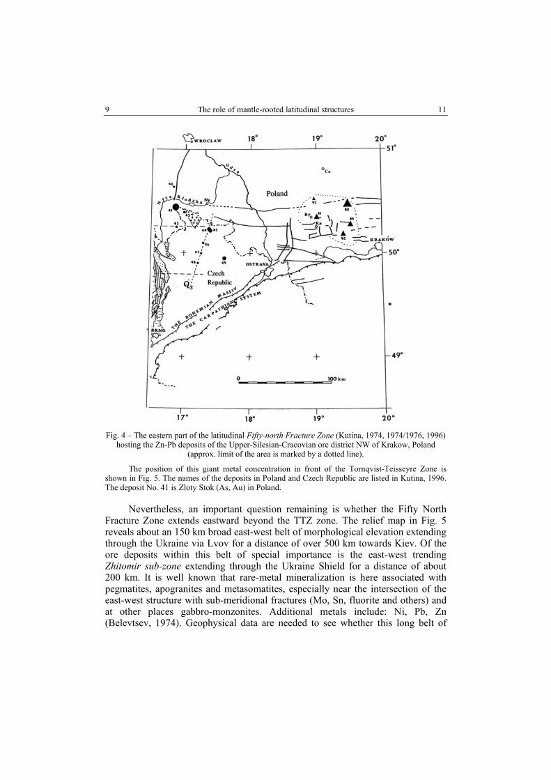
4. The ‘Fifty-north Fracture Zone’ (FnFZ) described by Kutina (1974 and 1974/1976) as extending through northern part of Bohemian Massif in the Czech Republic and continuing eastward into Poland – shown by axis C.
Figure 3 indicates that the FnFZ may also extend westward from the Czech Republic, playing a role in the control of Neogene volcanics at the intersection with the Rhine Graben. (segment D1). The examination of possible farther westward continuation of the FnFZ toward the granite massifs being associated with tin deposit in Devon and Cornwall (segment D2) is justified by the geologic and paleogeographic maps of P.A. Ziegler (1982, enclosures Nos. 2 and 5 to 11).
A remarkable correlation occurs between the latitude of the FnFZ and the structure of the Atlantic Ocean floor at positions D3 and D4 (Fig. 3). At D4, the Atlantic Ridge abruptly changes its course from northwest to northeast, the latter part referred to as the Reykjanes Ridge. The position of east-west fracture zones on the Canadian side of the Atlantic are described in Kutina, 1999.
3.2. POSSIBLE EASTERN CONTINUATION OF THE FIFTY-NORTH FRACTURE ZONE BEYOND THE TORNQVIST-TEISSEYRE ZONE
Of special importance to the Carpathians and the Romanian territory is the Fifty-north Fracture Zone (FnFZ). Figure 4 shows the easternmost, so far known, part of this zone in the territory of Poland. It hosts the major Upper Silesian – Cracovian Zn-Pb deposits in the Triassic rocks. A structural study by L. Teper (2006) has revealed east-west trends in the Paleozoic rocks beneath the Triassic cover, indicating possible pathways for the ascent of hydrothermal solutions into the overlaying Triassic sediments.
The location of the enormous concentration of the Upper Silesian – Cracovian zinc and lead ores at a distance not far from the Tornqvist-Teisseyre Zone (TTZ) – the western boundary of the East European platform - is of speciaI interest. Haranczyk (1988) has already noticed that the above huge metal concentration occurred close to the NW–SE trending Zawiercie-Rzeszotary geofracture that extends parallel to the TTZ.
The role of major sub-vertical fault zones acting either as ‘barriers’ hindering passage of hydrothermal solutions, or having an impact on fracturing and giving rise to a swarm of dikes and ore veins in the vicinity of a sub-vertical fault zone, is known from literature. A classic example, documented by mining operations down to a depth of about one and a half kilometers comes from the Ag-Pb-Zn Pribram district in the Czech Republic (Kettner, 1918; Kutina & Telupil, 1970).
9 The role of mantle-rooted latitudinal structures
11
Fig. 4 – The eastern part of the latitudinal Fifty-north Fracture Zone (Kutina, 1974, 1974/1976, 1996)
hosting the Zn-Pb deposits of the Upper-Silesian-Cracovian ore district NW of Krakow, Poland (approx. limit of the area is marked by a dotted line).
The position of this giant metal concentration in front of the Tornqvist-Teisseyre Zone is shown in Fig. 5. The names of the deposits in Poland and Czech Republic are listed in Kutina, 1996. The deposit No. 41 is Zloty Stok (As, Au) in Poland.
Nevertheless, an important question remaining is whether the Fifty North Fracture Zone extends eastward beyond the TTZ zone. The relief map in Fig. 5 reveals about an 150 km broad east-west belt of morphological elevation extending through the Ukraine via Lvov for a distance of over 500 km towards Kiev. Of the ore deposits within this belt of special importance is the east-west trending Zhitomir sub-zone extending through the Ukraine Shield for a distance of about 200 km. It is well known that rare-metal mineralization is here associated with pegmatites, apogranites and metasomatites, especially near the intersection of the east-west structure with sub-meridional fractures (Mo, Sn, fluorite and others) and at other places gabbro-monzonites. Additional metals include: Ni, Pb, Zn (Belevtsev, 1974). Geophysical data are needed to see whether this long belt of
Jan Kutina 10
12
topographic elevation reflects a mantle doming indicating eastward extension of the Fifty-north Fracture zone.
A supporting feature of the eastern extension of the Fifty-north fracture zone is the presence of the Kursk magnetic anomaly (KMA) which is centered, according to a Magsat satellite study by Taylor & Frawley (1987), at 50oN, within longitude 35o and 40oE (outside the limits of Fig. 5). It is referred to as one of the world’s largest amplitude magnetic anomalies. The geologic map of the Kursk magnetic anomaly area by Malyutin (in Kozlovsky, 1987, reproduced by Vanecek, ed., 1994, Fig. 12, p. 59) shows giant iron deposits in an area about 850 km long and 40–100 km wide, with the city of Kursk in the center.
3.3. THE TRANSYLVANIAN BASIN AND ASSOCIATED EAST-WEST FRACTURE ZONES
Figure 5 is aimed at discussing the role of the western boundary of the East European platform – the Tornqvist-Teisseyre zone (TTZ) – on structural development in Romania. The TTZ was transferred to Fig. 5 from Zielhuis’ (1992) S-wave velocity models for different depths (here using an 80-km depth at which the boundary was very well expressed). The differences in the manifestation of the TTZ along its length in Europe are described by Blundell et al., eds. (1992).
Figure 5 shows that the Carpathian Mts. bend in front of the TTZ from east-west to north-northwest, and a major cluster of earthquakes of the Vrancea area occurs exactly in the area at which the orogen bends.
Figure 6, complementary to the relief map in Fig. 5, shows the Mesozoic rocks extending around the Moesian Platform and the Transylvanian Basin, thus providing excellent documentation that the Moesian platform and the Transylvanian basin behaved as stable blocks in the Mesozoic time. The porphyry copper deposits, shown on the same map, do not occur inside these blocks.
The distribution of ore deposits of different types and ages as seen around the boundaries of the Transylvanian Basin on the Metallogenic Map of the Carpathians, 1: 1 000 000 (Lazarenko, ed., 1973) provides additional documentation about the basin as a stable lithospheric block which survived several processes, including the Alpine and Carpathian orogeny.
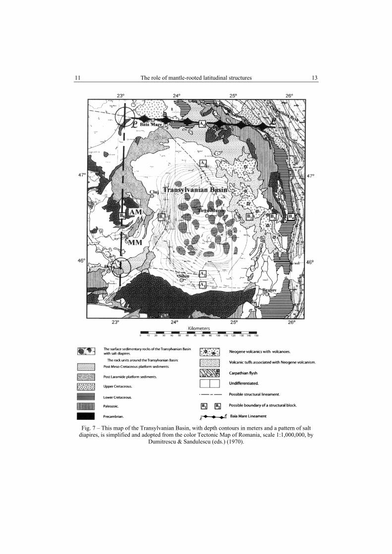
The geological evolution around the Transylvanian Basin is nicely expressed in the Tectonic Map of Romania at the 1:1,000,000 scale by Dumitrescu & Săndulescu (1970). Figure 7, prepared for this paper, presents a simplified, black/white version of the part of that map closest to the Transylvanian Basin. The position of the volcanic belt (shown with volcanic cones highlighted on the map) located close to the eastern boundary of the basin, indicates that the eastern edge of the basin is mantle-rooted and may have helped this block survive the orogenies.
The small squares with signatures A1, B1, etc. are used in Fig. 7 to discuss the size of the block: When estimating the size from the zero depth contour on the south and on the north (positions A1 and A3, respectively) and use the positions B1 and B2 on the west and east (tentatively placing the town Târgu-Mureş on the north-south axis of the basin), the size of the block would be approximately 160 × 115 km.
11 The role of mantle-rooted latitudinal structures
13
Fig. 7 – This map of the Transylvanian Basin, with depth contours in meters and a pattern of salt
diapires, is simplified and adopted from the color Tectonic Map of Romania, scale 1:1,000,000, by Dumitrescu & Sandulescu (eds.) (1970).

Jan Kutina 12
14
Fig. 7 (continued)
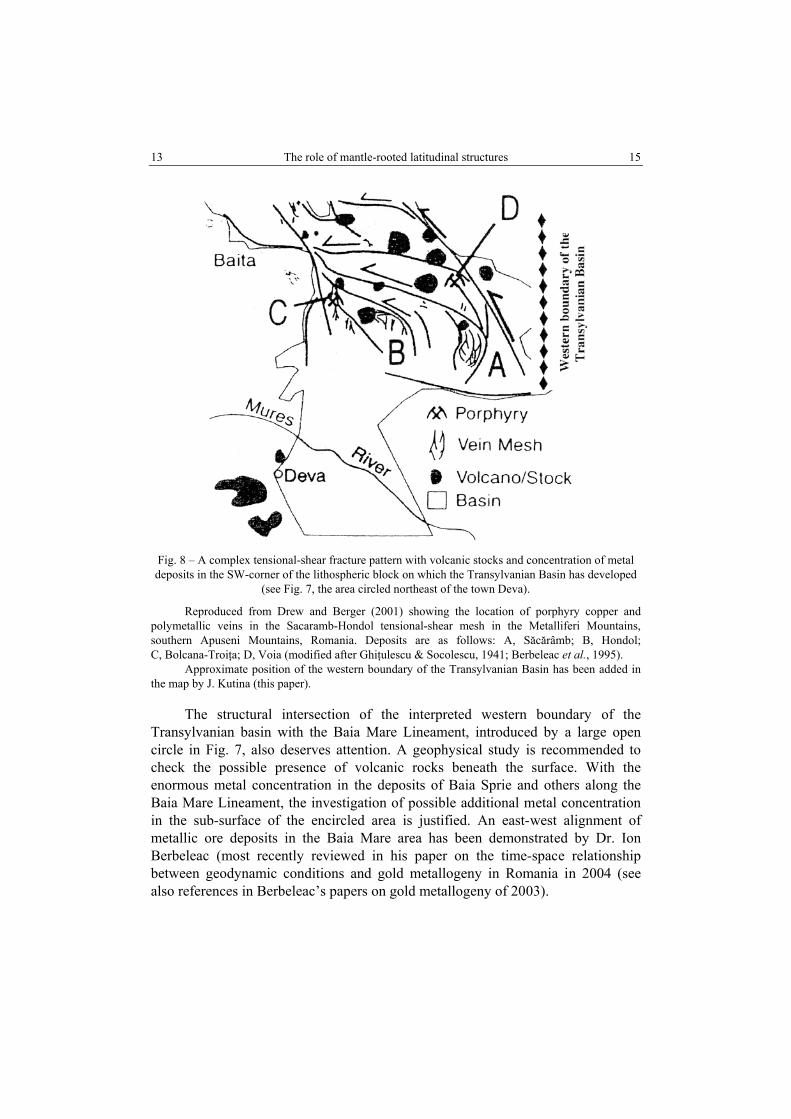
The markers A1, B1, etc. are used to discuss the size of the block: either by using the zero depth contours (size about 160 x 115 km), or by major tectonic boundaries (200 x 200 km). This second option understands the belt of volcanic rocks with volcanic cones as defining the eastern, mantle-rooted boundary of the lithospheric block. Similarly, the volcanic events in the Apuseni Mts. on the western side (described by Berbeleac, 2003) indicate the western block boundary, also mantle-rooted. The Baia Mare Lineament on the north, and the South Transylvanian Fault on the south complete the tectonic frame of the lithospheric block. Structures of four directions, including a NW–SE trending volcanic belt, intersect in the southwestern corner of the Transylvanian lithospheric block, providing a structural environment very favorable for concentration of metals. Confirmation is seen in Fig. 8 reproduced from Drew and Berger (2001). This observation may encourage investigation of possible mineral potential of the subsurface levels in the NW-corner of the same lithospheric block, along westward extension of the EW-trending Baia Mare Lineament which controls major volcanic-hosted deposits of gold and other metals (Baia Sprie and others).
If we rather take the major tectonic lines (fault zones) at either positions A1 or A2 on the south and position A4 on the north (here distinguishing a major east-west trending fracture zone as the Baia Mare Lineament (BML)∗ and take it as the northern boundary of the block), and positions B3 or B4 on the east and B5 on the west to define the block boundaries, then the size of the block is about 200 × 200 km. Structural importance of the east-west lineament at position A2 , referred to as Falia Sud-Transilvană, which extends farther east across the basin and controls two volcanic cones, has been substantiated by Seghedi et al. (2002). The position B5 in the Apuseni Mts. is chosen based upon the NS-trending structural break in the Precambrian rocks, filled with younger rocks, indicating a structural boundary, compatible with the rock distribution in the north which encloses the basin structure.
The configuration of structural units in the Metaliferi Mountains (Southern Apuseni Mountains) indicates that the interpreted NS-trending western boundary of the Transylvanian Basin extends south from the position of symbol B5. Here, northeast of the town of Deva (circled in Fig. 7), the following structures meet:
(1) A NW–SE belt of Neogene volcanic or sub-volcanic rocks; (2) a NE–SW belt of platform sediments; (3) the EW–trending South Transylvanian Fault; (4) the southern projection of the interpreted western boundary of the Transylvanian Basin (as a bisectrix of the angle between the NW– and NE– trending structures). This structural intersection, especially occurring in the corner area of a major lithospheric block, is a structural environment very favorable for concentration of metals. A confirmation can be seen in Fig. 8 after Drew & Berger (2001) showing the fault pattern, volcanic stocks and ore deposits in the southeastern tip of the volcanic belt, within the structural intersection circled northwest of Diva.
∗ A part of the BML probably correlates with the east-west lineament distinguished by Mioara Mandea in her poster presentation of the Images of the Romanian Territory by a Set of Geothematic Maps and Satellite Data (Mandea, 2004).
13 The role of mantle-rooted latitudinal structures
15
Fig. 8 – A complex tensional-shear fracture pattern with volcanic stocks and concentration of metal deposits in the SW-corner of the lithospheric block on which the Transylvanian Basin has developed
(see Fig. 7, the area circled northeast of the town Deva).
Reproduced from Drew and Berger (2001) showing the location of porphyry copper and polymetallic veins in the Sacaramb-Hondol tensional-shear mesh in the Metalliferi Mountains, southern Apuseni Mountains, Romania. Deposits are as follows: A, Săcărâmb; B, Hondol; C, Bolcana-Troiţa; D, Voia (modified after Ghiţulescu & Socolescu, 1941; Berbeleac et al., 1995).
Approximate position of the western boundary of the Transylvanian Basin has been added in the map by J. Kutina (this paper).
The structural intersection of the interpreted western boundary of the
Transylvanian basin with the Baia Mare Lineament, introduced by a large open circle in Fig. 7, also deserves attention. A geophysical study is recommended to check the possible presence of volcanic rocks beneath the surface. With the enormous metal concentration in the deposits of Baia Sprie and others along the Baia Mare Lineament, the investigation of possible additional metal concentration in the sub-surface of the encircled area is justified. An east-west alignment of metallic ore deposits in the Baia Mare area has been demonstrated by Dr. Ion Berbeleac (most recently reviewed in his paper on the time-space relationship between geodynamic conditions and gold metallogeny in Romania in 2004 (see also references in Berbeleac’s papers on gold metallogeny of 2003).
Jan Kutina 14
16
At the level of the crystalline basement, the isobath (km) contours as used by Polonic (1996, reprinted 2005, with Fig. 1 of 2000) reveal a basement structure of a size close to 300 x 300 km, extending about 100 km to the west of Apuseni Mts. The map of neotectonic vertical movement on the Romanian territory (Fig. 1 in Polonic, 2000), reveals a certain symmetry, with an inner component of a size close to 200 x 200 km, similar to the size of the lithospheric block controlling the Transylvanian Basin which I propose (Fig. 7).
3.4. LATITUDINAL STRUCTURES SOUTH OF THE TRANSYLVANIAN BASIN, EXTENDING CLOSE TO 45oS
Figure 5 shows that the Carpathian orogen, extending east-west close to 45oN latitude, turns north-northwesterly in front of the TTZ. It is remarkable that another turn occurs close to 50oN, where the Carpathians turn from northwest to east-west. It gives the impression that the Fifty-north fracture zone behaved as a barrier not allowing the orogeny to progress northwesterly along the TTZ, but forced it westward along the Fifty-north fracture zone through southern Poland and Slovakia. This turn, a westward continuation of the Carpathians along the Fifty-north fracture zone (FnFZ) is not surprising: the segments D1, D2, D3 and D4 in Fig. 3 trace the FnFZ across Europe and farther west in the Atlantic Ocean floor.
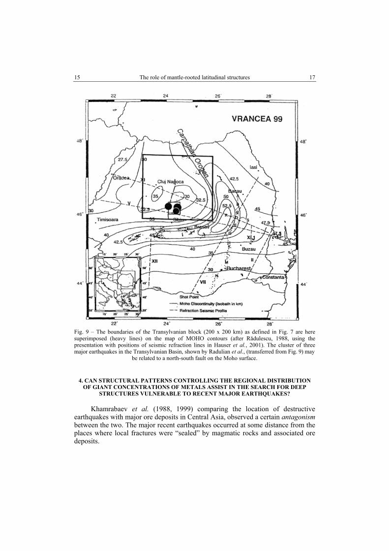
Based on the above explanation, the Fifty-north Fracture Zone can be understood as the ‘northern frame’ of the Carpathians. The following question arises: Where should another latitudinal structure comparable to FnF Z be expected? The contours of Moho discontinuity (after Rădulescu, 1988, adopted from Hauser et al., 2001), show a broad belt of east-west contours within latitudes 44–45oN extending toward the Black Sea basin (Fig. 9). These east-west contours of Moho essentially match a prominent EW-structure that extends along the northern boundary of the Black Sea toward the Romanian border (VSEGEI, 1979, 1982). Inside the Black Sea basin, there are known east-west fracture zones. Damian & Zugrăvescu (2002, p. 111) show an impressive one, extending east-west toward the western tip the Crimean Peninsula.
The spacing between the Fifty-north fracture zone and the east-west contours of Moho, measured at 45oN latitude, is 600 km. This corresponds to the spacing of the main latitudinal structures in the United States (Fig. 1) as well as to the spacing of the main EW-belts in China (see section no. 2 in this paper).
The contour map of geoisotherms as shown in the Geothermal Map of Romania, at 1:1,000,000 scale (Institute of Geology and Geophysics, 1985) reveals a prominent east-west boundary at the latitude of Bucharest (close to 44o30’N, as well as in the southern part of the Black Sea coastal region). The above data show that the latitudinal belt in the Moho contours within 44o and 45oN should be understood to be of fundamental structural importance.
15 The role of mantle-rooted latitudinal structures
17
Fig. 9 – The boundaries of the Transylvanian block (200 x 200 km) as defined in Fig. 7 are here superimposed (heavy lines) on the map of MOHO contours (after Rădulescu, 1988, using the presentation with positions of seismic refraction lines in Hauser et al., 2001). The cluster of three major earthquakes in the Transylvanian Basin, shown by Radulian et al., (transferred from Fig. 9) may
be related to a north-south fault on the Moho surface.
4. CAN STRUCTURAL PATTERNS CONTROLLING THE REGIONAL DISTRIBUTION OF GIANT CONCENTRATIONS OF METALS ASSIST IN THE SEARCH FOR DEEP
STRUCTURES VULNERABLE TO RECENT MAJOR EARTHQUAKES?
Khamrabaev et al. (1988, 1999) comparing the location of destructive earthquakes with major ore deposits in Central Asia, observed a certain antagonism between the two. The major recent earthquakes occurred at some distance from the places where local fractures were “sealed” by magmatic rocks and associated ore deposits.
Jan Kutina 16
18
The above observation has inspired a more detailed comparison between the structures controlling giant ore deposits of endogenic origin and the structures at which strong catastrophic earthquakes occurred. The following examples can encourage further research (Kutina et al., 2006):
1. A cluster of large ore deposits in the Salt Lake City area of the western United States, including the superlarge Bingham Canyon Cu-Au-Mo porphyry.
These deposits are spread within an area of 50–100 square kilometers, each related to crustal structures and lithology. However, on a broad regional scale, all of these deposits belong to one ore cluster controlled by the intersection of mantle-rooted structural discontinuities here trending primarily E–W and N–S, with metal concentration near the corner of a major lithospheric block (Kutina, 1983) (Fig. 2). The N–S structure is manifested by the Intermountain Seismic Belt. The emplacement of the igneous bodies and associated ore deposits was accompanied with the reopening of fractures, brecciation, and other geological processes. The reconstruction of the Bingham Canyon/Barneys Canyon area during the emplacement of the Cu-Au-Mo deposit with a volcanic event 37 million years ago (Cunningham et al., 2004) would be difficult to imagine without earthquakes. The tectono-magmatic processes giving rise to the whole cluster of the Salt Lake City ore deposits have apparently sealed the import channels guiding the heat, magmas and hydrothermal fluids into the upper crust, preventing the present Salt Lake City area from the danger of a recent catastrophic earthquake.
2. The Tangshan earthquake of NE China at a focal depth of 10 km. This earthquake was manifested in the earth’s surface on a NE-trending fault,
in places of its intersection with a regional E–W tectono-seismic zone (Guo et al., 1977). The epicenter, transferred onto the relief of Moho discontinuity, compiled by Feng Rui et al. (1989), reveals a relation to the same structural directions as at the surface or in the uppermost crust, here where the NE–SW depth contours of Moho (close to 30 km) bend to an east-west direction. The depths of the aftershocks (up to over 120 km) indicate that the focus and the surface expression of the earthquake are related to mantle-rooted structures. It seems that the recurrence of major earthquakes in this area is not protected by “sealing” of the import channels by igneous rocks, and major earthquakes could occur in the future.
Although many structural intersections in different geological environment have to be investigated before generalizations can be made, the above two examples indicate that:
(a) The mantle-rooted structures, especially at intersections with other deep-seated structures, can guide the ascent of heat, magmas and associated mineralization. Due to the common multi-phase and polyascendent nature of the processes, manifested by the reopening and subsequent filling of fractures, brecciation and new phases of magmatism, earthquakes can occur during the formation of major ore deposits and ore clusters.

17 The role of mantle-rooted latitudinal structures
19
(b) Some of the mantle-rooted structures have not been used by magmas and associated mineralization, the import channels being unsealed by igneous rocks, remain vulnerable to major recent earthquakes.
It is important to distinguish between the two cases above and define structural intersections which are vulnerable to major recent earthquakes. Actual occurrence of a strong earthquake in such areas depends, naturally, on regional stress distribution which can change over the course of time. An example of an area which has been defined as vulnerable to strong earthquakes occurs along eastward extension of the Forty-north discontinuity across the Korean Peninsula, within the same latitudes at which the Tangshan earthquake in NE China occurred, with a death toll of over 200,000 people (Kutina et al., 2006).
3. Possible application to Romania The extensive studies of seismicity in Romania and the many papers recently
reproduced in two volumes, one focused on Vrancea area (Zugrăvescu & Şuţeanu, 2004, 2005) and the results of a joint German-Romanian project (Hauser et al., 2001, 2002) provide a unique opportunity to address some basic questions.
The geographic distribution of seismogenic zones and crustal seismicity of Romania, as presented by Radulian et al. (2000) defines several major earthquake clusters, some in marginal parts of Romania (Fig. 10). It is remarkable that no major earthquakes are shown in the Apuseni Mountains. Berbeleac (2003), in his excellent and detailed description of the tectono-magmatic and metallogenic evolution in the Apuseni and Metaliferi Mts., refers to volcanic and subvolcanic multi-stage processes, to stratovolcanoes and ring structures, and even to explosive volcanic activity. These processes cannot be imagined without major earthquakes. The reason why no major recent seismic events were recorded in that area, can be explained similarly to the Salt Lake City area of the United States: the conduits which in the Apuseni Mts. guided the ascent of heat, magmas and ore-forming fluids, were essentially “sealed” by intrusive rocks, making these pathways less vulnerable to processes controlling major earthquakes.
To the east of the Apuseni Mts, within comparable latitudes, the map (Fig. 10) by Radulian et al. (2000) shows a small cluster of major earthquakes in the Transylvanian Depression. Transferred onto the map of Moho discontinuity of Romania (Fig. 9), this cluster occupies a structurally important position with regard to a N–S structure distinguished by Radulian et al., most probably at intersection with a deep-seated structure of another trend, possibly an east-west one. Although documentation is needed I expect that the tectonic conduits have not been “sealed” by intrusive rocks and new earthquakes could occur.
The map of earthquake clusters (Fig. 10) invites the reader to discuss how seismic energy was transferred to areas of the individual clusters. Professor Dorel Zugrăvescu and his co-workers are investigating this question with regard to the Vrancea area, the biggest earthquake cluster in Romania.

Jan Kutina 18
20
Fig. 10 – The geographic distribution of seismogenic zones and crustal seismicity in Romania (after
Radulian et al., 2000) referred to in the text and in Fig. 8.
The pattern of intermediate-depth earthquake foci of Vrancea, as revealed by 3-D magnetotelluric tomographic imaging and plotted graphically for the depths between 100 and 150 km (Stănică et al., 2004) can be used as documentation for the Vrancea earthquakes occurring on mantle-rooted structures.
The repeated occurrence of earthquake in this zone indicates that the pathways guiding the seismic energy have not been sealed by intrusives and may be followed by new earthquakes (18 events of magnitude higher than 6, from 1600 through May 1990 are listed by Stănică et al., 2004; 120 events of magnitude 5.5 and higher from the year 984 through May 31, 1990 is listed by Sandi, 2002; and 29 low magnitude events 3.1 to 4.3 from June 10, 2000 through Sept. 29, 2000 by Zugrăvescu et al., 2000).
Zugrăvescu & Damian (1999) investigated the tectonics and stress distribution in the Black Sea coastal region of Dobruja between the Black Sea and the Vrancea seismic area, in the context of interaction of the Eurasian plate with the African and Arabian plates. The authors considered stress propagation towards the Vrancea zone through this region penetrated by major NW–SE trending faults. A new study of the Vrancea foreland area (Zugrăvescu & Polonic, 2003) includes

19 The role of mantle-rooted latitudinal structures
21
deep cross sections with positions of the Conrad and Mohorovicic discontinuities, as well as maps of the basement fault systems, providing new background for seismic events prediction.
The question remains as to when the next major earthquake can be expected. The list of 120 earthquakes of the Vrancea area, of magnitude 5.5 and higher, from the year 984 through May 31, 1990, has been used by Sandi (2002) to calculate the periodicity of occurrence of earthquakes of different magnitude which enables some prediction. With regard to the real possibility of stress transfer from the Black Sea area toward the Vrancea zone, it may also be useful to compare the periodicity of the Vrancea earthquakes with the dates of major earthquakes along the North Anatolian Fault in Turkey.
Although the upper crust structure of the North Anatolian Fault is quite complex and detailed maps from different sections of the fault are available (e.g. Dewey et al., 1986; Kiratzi & Louvari, 2001; Karahan et al., 2001; Seeber et al., 2004), a simple plot of the main earthquakes as used by Appenzeller (1999) is very useful (Fig. 11). The figure shows that eight large earthquakes occurred on the North Anatolian Fault in a westward propagation along a distance of 1000 km, beginning in 1939 in eastern Turkey of magnitude 7.9 with a death toll of over 20,000 people. The westward propagation of seismic energy gave rise to an earthquake at Izmit on August 17, 1999 with a magnitude 7.4 and as close as 100 km east of Istanbul (followed by another one near Bolu east of Izmit, on November 12, 1999 – shown on a structural map by Kiratzi & Louvari, 2001).
Fig. 11 – The westward propagation of major earthquakes along the North Anatolian Fault in Turkey
(after Appenzeller, 1999).
Note the interval of a few years between earthquakes on the eastern side of the fault, while the interval between the events of 1957 and 1967 (10 years) and between 1967 and 1999 (32 years) were considerably longer on the western side, closer to Istanbul.
Reproduced after SCIENCE, vol. 285, No. 5432, p.1334, August 27, 1999.

Jan Kutina 20
22
Figure 11 reveals that the earthquakes on the eastern side of the North Anatolian Fault occurred in intervals of a few years, while on the western side the interval between the events of 1957 and 1967 was 10 years, and between the quakes of 1967 and 1999 it was 32 years.
When comparing, the Vrancea area earthquakes from 1939 through May 31, 1990 as listed by Sandi, 2002, the events from the years 1939 –1950 occurred in intervals of about 1 to 3 years, but during the period of June 20, 1950 to May 31, 1990, two intervals were about 10 years long (from June 20, 1950 to October 13, 1960, and from March 4, 1977 to August 30, 1986), other intervals of 4 years (2x), 6 years (1x), and 7 years (1x).
The above comparison shows that the interval between the individual major seismic events were becoming, in general, longer in time, both along the North Anatolian Fault (NAF) and in the seismic zone of Vrancea. As the changes along the NAF proceeded progressively from the east toward the west, closer to Romania, the question arises as to whether or not some relationship exist between the above two sequences of major seismic events.
The seismic events along the NAF may be, at least partly, related to motion along the East Anatolian Fault Zone (EAFZ) which extends, in eastern Turkey, northeasterly to the NAF (ref. to Taymaz et al., 1991). Nalbant et al. (2002, Fig. 1) characterize the EAFZ as a 580 km left-lateral strike-slip transform boundary between the northward moving Arabian Plate and westward moving Anatolian Block. Nalbant et al. note that the EAFZ has been relatively quiescent in the last century when compared to historical records and has therefore accumulated significant stress along its length. The authors have distinguished between segments of the EAFZ which were continuously releasing stress, and segments where the stress accumulated. According to their prediction, an earthquake of magnitude 6.4 occurred at Bingol on May 1, 2003, in one of the segments which Nalbant et al. (2002) defined as posing a seismic risk.
If the sequence of seismic events in the Vrancea area is related to the westward stress progression along the North Anatolian Fault, this should probably be understood to be just a component in the total cumulative stress coming from more than a single source. The present day stress field and the stress source regions have been addressed in the context of geodynamic evolution of a broad region by Zugrăvescu & Damian (1999) and Zugrăvescu & Polonic (2002).
5. CONCLUSIONS
The author reviews the role of E–W trending mantle-rooted structural discontinuities in concentration of metals in the crust, preferentially occurring at intersections with deep structures of other trends which guided the ascent of heat, magmas and ore-forming fluids into the upper crust. Elaborating on Kutina et al.

21 The role of mantle-rooted latitudinal structures
23
(2006), the author distinguishes between structural intersections whose deep-seated conduits have been “sealed’ by igneous intrusions protecting the area from recent strong earthquakes (such as the ore cluster in the Salt Lake City area of the western United States and, the Apuseni and Metaliferi Mts. in Romania), and those intersections whose deep-seated conduits have not been sealed by intrusives and remain vulnerable to recent strong earthquakes (such as the Tangshan area in NE China with the catastrophic earthquake of 1976, and the Vrancea zone in Romania). The examination of the role of structural parameters on regional distribution of the main ore and earthquake clusters in Romania and it’s adjacent countries, has revealed a combined role of the NW–SE trending Tornqvist-Teisseyre Zone, the latitudinal structures, and the boundaries of pre-Mesozoic lithospheric blocks. The following observations have been made:
1. The distribution of the Mesozoic rocks as expressed in the extract from the BRGM Metallogenic map of Central and Southeastern Europe (Cassard et al., 2006; Fig. 6), compared with the relief map of the same area (Fig. 5) shows that the orogenic process proceeded around the Moesian Platform following it latitudinally on both the southern and northern side, then turning north-northwesterly along the TTZ and around the eastern boundary of the Transylvanian Basin. When approaching the proximity of the 50oN latitude, the Carpathian orogeny turned westward, again latitudinally, following the deep-seated Fifty-north Fracture Zone which was described by Kutina (1974, 1974/1976). The TTZ had, apparently, an impact not only on the bending of the Carpathians, but also on the origin of the seismic zone of Vrancea in places of the bending (Fig. 5). Some authors explain the seismicity at Vrancea as on a triple junction (Beşuţiu & Cadicheanu, 2002; Stănică et al., 2004). Another impact of the TTZ can be seen in southern Poland, where intensive fracturing and hydrothermal activity occurred along the Fifty-north Fracture zone (FnFZ) in front of the TTZ, giving origin to the Upper Silesian-Cracovian Zn-Pb district, one of the biggest zinc ore concentrations in Europe (Figs. 4 and 5). With regard to the role played by the FnFZ in Europe (Fig. 3), it was of special interest to examine whether or not the FnFZ extends farther east beyond the TTZ. The relief map (Fig. 5) reveals a 150 km broad east-west zone of morphological elevation which may represent eastward continuation of the FnFZ beyond the TTZ. The east-west trending Zhitomir zone of the Ukrainian Shield, known to be rich in rare metals, extends along the same latitudes as the Zn-Pb ores of Upper Silesia. Although geophysical confirmation is needed to prove the eastward extension of the FnFZ, the location of the Kursk magnetic anomaly centered at 50oN latitudes (Taylor & Frawley, 1987) with giant iron deposits in the vicinity provides supportive criterion.
The Fifty-north Fracture Zone along which the Carpathians turn westward can be considered the ‘northern frame’ of the Carpathian region. Another latitudinal deep-seated structure, of importance comparable to the FnFZ, is the latitudinal belt expressed in the Moho surface as extending within latitudes
Jan Kutina 22
24
44–45 N (Fig. 9). The spacing between the above two latitudinal zones is about 600 km, surprisingly correlating with the 600 km spacing between the main latitudinal discontinuities in the western United States and the east-west belts of China. Between the above two latitudinal belts of the Carpathian region, there are structurally less significant, but still metallogenically important east-west fracture zones, in particular one on the northern side of the Transylvanian Basin, in this paper referred to as the Baia Mare Lineament. And the east-west fracture zones limiting the Transylvanian block on its southern side (Fig. 7).
The Transylvanian Basin is, in this paper, interpreted as a lithospheric blocks of a size about 200 x 200 km, with a belt of volcanic rocks on its eastern side and the metal rich Apuseni and Metaliferi Mts. on its western side.
The seismicity of Vrancea area, being under extensive study by Romanian scientists, has been set by D. Zugrăvescu and colleagues in the context of a broader region, in particular the Black Sea area. The periodicity of seismic events, using the data in Sandi (2002), is in this paper compared with the westward progression of earthquakes along the North Anatolian Fault, indicating similarity in the increase of intervals between the earthquakes with time.
Acknowledgements. I want to extend my sincere thanks to Professor Dorel Zugrăvescu, Director of the “Sabba S. Ştefănescu” Institute of Geodynamics, Romanian Academy, for inviting me to submit this paper, based on my seminar lecture at the Institute on March 23, 2006. My thanks are also expressed to Professor Angela Crăciun, President of the Organisation Mondiale de Mineralogie, for initiating this invitation. The preparation of the manuscript benefited from my cooperation with the Eastern Mineral Resources Team, U.S. Geological Survey. Best thanks are due to Dr. Arthur P. Schultz, Chief of the Eastern Mineral Resources Team, Dr. Klaus Schulz, Chief of the Global Mineral-Resource Assessment Project, and Dr. Bruce Lipin for the support given my work and for valuable advice. The cartographic work, connected with preparation of the illustrations for this paper, provided by Mr. Walter J. Bawiec and Mr. Paul Schruben is greatly appreciated.
My special thanks belong to Dr. Daniel Cassard of the BRGM – French Geological Survey in Orleans, France, for his kind permission to use an Extract from the new BRGM Metallogenic Map of Central and Southeastern Europe, quoted in the References, for Fig. 6 in this paper.
Best thanks to Edward G. Boyce for reading the manuscript and providing valuable advice. However, the author is himself responsible for all interpretations.
REFERENCES
AFFLECK, J. (1970), Definition of regional structures by magnetics. In: H. Johnson & B.L. Smith (eds.): The Megatectonics of Continents and Oceans. Rutgers Univ. Press, New Brunswick, N.J.
APPENZELLER, T. (1999), In Turkey, Havoc From a Falling-Domino Fault. Science, 285, 1334–1335. ATWATER, T. (1970), Implications of plate tectonics for the Cenozoic tectonic evolution of Western
North America. Geol. Soc. America Bull., 81, 3513–3536. BACHMANN, G.H., GROSSE, S. (1989), Struktur und Entstehung des Norddeutschen Beckens.
Geologische und geophysikalische Interpretation einer verbesserten Bouguer-Schwerekarte. Vroeff. der Niedersaechsischen Akademie der Geowissenschaften, Heft 2 (1989), 24–47, Hannover.
23 The role of mantle-rooted latitudinal structures
25
BELEVTSEV, YA.N. (ed.) (1974), Metallogeniya Ukrainy i Moldavii. (Metallogeny of the Ukraine and Moldavia). Kiev, publ. by “Naukova Dumka”, 511 p., (in Russian).
BERBELEAC, I. (2003), Time-space geodynamic evolution of Tertiary magmatic and metallogenetic activity in South Apuseni Mountains, Romania. St. cerc. Geofizică, Academia Română, 41, 19–56.
BERBELEAC, I. (2004), Relationships between Geodynamic Conditions and Gold Metallogeny in Romania. The First International Mineralogy Days of Monaco. Program with Abstracts, Organisation Mondiale de Mineralogie, September 2004.
BERBELEAC, I., ILIESCU, D., ANDREI, J., CIUCULESCU, O., CIUCULESCU, R. (1995), Relationships between alterations, porphyry copper-gold and base metal-gold hydrothermal vein mineralizations in tertiary intrusions, Tălagiu area, Zarand Mountains. Romanian Journal of Mineral Deposits, 76, 31–39.
BEŞUŢIU, L., CADICHEANU, N. (2002), Preliminary considerations on the space-time migration of the Vrancea intermediate-depth seismicity. In: D. Zugrăvescu & L. Beşuţiu (eds.): “The natural geodynamic laboratory Vrancea, a challenge for the 21st century”, 25–33, Institute of Geodynamics, Romanian Academy, Bucharest.
BLUNDEL, D., FREEMAN, R., MUELLER, S. (eds.) (1992), A Continent Revealed. The European Geotraverse. Cambridge Univ. Press, 275 p.
BOWES, W.A., KUTINA, J., AAKER, S.K., FREDRIKSSON, K., GOLIGHTLY, D.W. (1982), A porphyry-type Mo-Cu discovery at Granite Mountain, Nevada. Predictions based on mineralogical and geochemical study of zoning. Global Tect. & Metall., 1 (4), 402–439.
BOWIN, C., WARSI, W., MILLIGAN, J. (1982), Free-Air Gravity Anomaly Map of the World. The Geological Society of America Map and Chart Series MC-45.
CASSARD, D., LIPS, L.W., LEISTEL, J.-M., STEIN, G. (Coordinators) (2006), Metallogenic map of Central and South-Eastern Europe: An extract from GIS Europe. BRGM Report BRGM/RP-54703-FR.
CUI SHENGQIN, WU ZHENHAN, PEI RONGFU, KUTINA, J. (2006), Evolution of 3-dimensional tectonics in the lithosphere and metallogenesis of the Yanshan intracontinental orogenic belt, China. Global Tect. & Metall., 9 (1–4), (in press).
CUNNINGHAM, C.G., AUSTIN, G.W., NAESER, C.W., RYE, R. O., BALLANTYNE, G.H., STAMM, T.G., BARKER, C.E. (2004), Formation of a paleothermal anomaly and disseminated gold deposits associated with the Bingham Canyon porphyry Cu-Au-Mo system, Utah. Economic Geology, 99 (4), 789–806.
DAMIAN, A., ZUGRĂVESCU, D. (2002), Fenomene dinamice din domeniul nord-vest pontic si influente posibile asupra zonei seismogene Vrancea. In: D. Zugrăvescu & L. Beşuţiu: “The natural geodynamic laboratory Vrancea, a challenge for 21st century”, 99–128.
DREW, L.J., BERGER, B.R. (2001), Model of the porphyry copper/polymetallic vein kin-deposit system: Application in the Metaliferi Mountains, Romania. In: “Mineral Deposits at the Beginning of the 21st Century”, A. Piestrzynski et al. (eds.), 519–522, Swets & Zeitlinger Publishers Lisse.
DUMITRESCU, I., SĂNDULESCU, M. (eds.) (1970), Roumanie, Carte Tectonique, Echelle 1:1,000,000, Institutul Geologic, Bucureşti, Atlas Geologic, Foaia 6.
FAVORSKAYA, M.A., TOMSON, I.N., BASKINA, V.A., VOLCHANSKAYA, I.K., POLYAKOVA, O.P. (M.A. FAVORSKAYA & I.N. TOMSON , eds.) (1974), Global’nye zakonomernosti razmeshcheniya krupnykh rudnykh mestorozhdenii (Global Regularities in the Distribution of Large Ore Deposits). Moscow, publ. by Nedra, 93 p., (in Russian).
FENG RUI, HUANG GUIFANG, ZHENG SHUZHEN, WANG JUN, YAN HUIFEN, ZHANG RUOSHUI (1989), The crustal structure and seismic activity in north China. Acta Geologica Sinica, 2 (4), 343–360, (Quoted after Cui et al., 2006).
Jan Kutina 24
26
FULLER, M.D. (1964), Expression of E–W fractures in magnetic surveys in parts of the U.S.A. Geophysics, 29 (4), 602–622.
GHIŢULESCU, T.P., SOCOLESCU, M. (1941), Étude géologique et minière des Monts Metallifères. Anuarul Institutului Geologic al României. 21,185–464, (Quoted after L.J. Drew & B.R. Berger, 2001).
GUO S., LI Z., CHENG S., CHEN X., YANG Z, & LI R. (1977), Discussion on the regional structural background and the seismogenic model of the Tangshan earthquake. Scientia Geologica Sinica, No. 4, 305–321, (in Chinese with English summary).
HALLOF, P.G. (1982), Reconnaissance and detailed geophysical results, Granite Mountain area, Pershing County, Nevada. Global Tect. & Metall., 1 (4), 374–400.
HARANCZYK, C. (1988), Znaczenie suturalnego rozlamu wglebnego Zawierce-Rzeszotary dla powstania i rozmieszenia Paleozoicznej i zloz rud Zn–Pb. Przeglad Geologiczny, XXXVI, 7 (423), 379–381, (in Polish).
HAUSER F., PRODEHL, C., LANDES, M. & the Vrancea working group (2002), Seismic experiment target earthquake-prone region in Romania. EOS, Transactions, American Geophysical Union, 83 (41), 457, 462–43.
HAUSER, F., RĂILEANU, V., FIELITZ, W., BALA, A., PRODEHL, C., POLONIC, G., SCHULZE, A. (2001), VRANCEA 99 – The crustal structure beneath in the southeastern Carpathians and the Moesian Platform from a seismic refraction profile in Romania. Tectonophysics, 340 (3–4), 233–256.
HEYL, A.V. (1972), The 38th Parallel Lineament and its relationship to ore deposits. Econ. Geology, 67, 879–894.
HEYL, A.V., KUTINA, J. (1994), Giant ore deposits of the United States. Investigating the pattern of distribution (excluding Alaska). 9th IAGOD Symposium, Abstract Volume, I, 4–5, Beijing, China.
HILDENBRAND, T., SIMPSON, R.W., GODSON, R.H., KANE, M.F. (1982), Digital colored residual and regional Bouguer gravity maps of the conterminous United States with cut-off wavelengths of 250 km and 1000 km. Scale 1:7,500.000. U.S. Geol. Survey Geophys. Investigation map (Map GP-953-A).
INSTITUTE OF GEOMECHANICS’ COMPILATION GROUP, CHINESE ACAD. GEOL. SCI. (1978), Explanation text to the 4,000,000 Tectonic System Map of the People’s Republic of China (with a simplified map of the Principal Tectonic Systems, scale 1: 15,000,000). Beijing, Geol. Publ. House, (in Chinese).
INSTITUTUL DE GEOLOGIE ŞI GEOFIZICĂ (1985), Romania, Geothermal Map, scale 1:1,000,000. Atlas Geologic, Foaia 15, Bucharest.
KARAHAN, A.E., BERCKHEMER, H., BAIER, B. (2001), Crustal structure at the western end of the North Anatolian Fault Zone from deep seismic sounding. Annali di Geofisica, 44 (1), 49–68.
KETTNER, R. (1918), Novy geologicky profil pribramskymi doly a pribramskym okolim. (A new geological profile of the Pribram mines and the Pribram area). Sbornik Ceske spolecnosti zemevedne, 24, Praha, (in Czech).
KHAMRABAEV, I.KH., SEIDUZOVA, S.S., MATASOVA, L.M., YANKOVSKAYA, N.N. (1988), The phenomenon of negative relationship (antagonism) between localization of endogenic ore deposits and epicentral zones of strong and destructive earthquakes. Uzbek. Geol. Journ., No. 3, 15–28, (in Russian).
KHAMRABAEV, I. KH., SEIDUZOVA, S., MATASOVA, L., YANKOVSKAYA, N. (1999), Distribution of main ore deposits and strong earthquakes in regard to the lithospheric structure of Central Asia. Global Tect. & Metall., 7 (1), 27–38.
KIRATZI, A., LOUVARI, E. (2001), Source parameters of the Izmit-Bolu 1999 (Turkey) earthquake sequences from teleseismic data. Annali di Geofizica, 44 (1), 33.
25 The role of mantle-rooted latitudinal structures
27
KUTINA, J. (1974a), Structural control of volcanic ore deposits in the context of global tectonics. Bull. Volcanologique, 38 (4), 1039–1069.
KUTINA, J. (1974b), The Fifty-north Fracture Zone and its role in metallogeny of Central Europe). Chemie der Erde, 33 (2), 215–217.
KUTINA, J. (1974/1976), Relationship between the distribution of big endogenic ore deposits and the basement fracture pattern – Examples from four continents. First International Conference on the New Basement Tectonics, June 1974, Salt Lake City, Utah Geol. Assoc. # 5, p. 565–593, 1976.
KUTINA, J. (1980), Regularities in the distribution of ore deposits along the ‘Mendocino latitude’, western United States. Global Tect. & Metall., 1 (2), 134–193.
KUTINA, J. (1983a), Global tectonics and metallogeny: Deep roots of some ore-controlling fracture zones. A possible relation to small-scale convective cells at the base of the lithosphere? In: Advances in Space Research, 3 (2), 201–214. Publ. by Pergamon Press.
KUTINA, J. (1983b), Similarities in the deep-seated controls of mineralization between the United States and China. Global Tect. & Metall., 2 (1& 2), 111–142.
KUTINA, J. (1986a), A study of residual gravity maps to delineate deep controls of ore deposits in the Colorado Mineral Belt. In: M.J. Aldrich & A.W. Laughlin (eds.), 6th International Conference on Basement Tectonics, Proceedings, 175–188. Publ. by Internat. Basement Tectonics Assoc., Salt Lake City, Utah.
KUTINA, J. (1986b), The role of basement tectonics in the distribution of some major ore deposits of Mesozoic and Cenozoic ages. Symposium on Mesozoic and Cenozoic Geology, Proceedings, Editor-in-Chief: Huang Jiqing. Beijing, Geol. Publ. House, 555–570.
KUTINA, J. (1988a), Deep controls of ore deposits in the western United States examined by residual gravity maps, magnetic and seismic data. In: G. Kisvarsanyi & S.K. Grant (eds.): “North American Conf. on Tectonic Control of Ore Deposits and the Vertical and Horizontal Extent of Ore Systems”, Proceedings Volume, 14–35, University of Missouri-Rolla, Missouri.
KUTINA, J. (1988b), Criteria indicating a block structure of the upper mantle and its role in metallogeny. In: E. Zachrisson (ed.), Proceedings 7th IAGOD Symp., Lulea, Sweden, August 1986, publ. by Schweizerbart, Stuttgart, 1988, 111–120.
KUTINA, J. (1991), Metallogeny of mantle-rooted structures extending across the western edge of the Proterozoic North American craton. Global Tect. & Metall., 4(1), 21–51.
KUTINA, J. (1995), Regional mantle-rooted discontinuities extending transversely to the margins of cratons and adjacent mobile belts. Metallogenic implications. Global Tect. & Metall., 5 (1&2), 7–18.
KUTINA, J. (1996), The role of mantle-rooted structural discontinuities in concentration of metals. With an example from the Bohemian Massif set in the context of Central and Western Europe. Global Tect. & Metall., 5 (3& 4), 79–102.
KUTINA, J. (1999), The role of transregional mantle-rooted structural discontinuities in global metallogeny: Transatlantic similarities between E-W structures of North America and Europe, and examples from Asia and Australia. Abstracts, IGCP-354 Workshop SGA-IAGOD Meeting, London, August 1999, (Extended abstract, distributed at the workshop).
KUTINA, J. (2006), Metallotect-potential zones – a powerfull tool for defining targets in mineral exploration. 12th IAGOD Symposium, Moscow, August 2006, Session S7: “Deep Tectonic Processes with Super Accumulation of Metals in the Lithosphere” (Chairmen: Rongfu Pei & Jan Kutina). Extended Abstract.
KUTINA, J., BOWES, W.A. (1982), Structural criteria defining the Granite Mountain area in NW-Nevada as a target for mineral exploration. Global Tect. & Metall., 1 (4), 336–354.
Jan Kutina 26
28
KUTINA, J., CUI, S., PEI, R., JIANG, M. (2006), A deep-seated E–W trending structural boundary indicated as extending across the Korean Peninsula at a latitude close to 40oN. Implications for defining areas with potential for strong earthquakes. Global Tect. & Metall., 9 (1–4), (in press).
KUTINA, J., HILDENBRAND, T.G. (1987), Ore deposits of the western United States in relation to mass distribution in the crust and mantle. Geol. Soc. America Bull., 99 (1), 30–41.
KUTINA, J., NORTON, M.F. (1978), Block structure of the Precambrian basement in Central and Eastern United States indicated by a mosaic of basins and uplifts in its sedimentary cover. Metallogenic implications. Global Tect. & Metall., 1 (1), 53–77.
KUTINA, J., PEI, R., HEYL, A.V. (2003), The role of deep lithospheric structure in the genesis and distribution of giant and supergiant concentrations of metals in the crust. With a review of the main data generated by the IGCP-354. “Economic Superaccumulations of Metals in the Lithosphere”. Global Tect. & Metall., 8 (1–4), 9–49.
KUTINA, J., POKORNY, J., VESELA, M. (1967), Empirical prospecting net based on the regularity distribution of ore veins with application to the Jihlava Mining District, Czechoslovakia. Econ. Geology, 62, 390–405. Correction in 62: 1010.
KUTINA, J., TAYLOR, P.T. (2003), Satellite altitude magnetic anomalies – Implications for mineral exploration: A review. Global Tect. & Metall., 8 (1–4), 89–105.
KUTINA, J., TELUPIL, A. (1970), The vertical extent of ore deposition in Pribram, Czechoslovakia. In: Z. Pouba & M. Stemprok (Eds.): Problems of Hydothermal Ore Deposition. IUGS, Ser. A, No. 2, 187–193. Schweizerbart, Stuttgart.
LANGEL, R.A., PHILLIPS, J.D., HOMER, H.J. (1982), Initial scalar magnetic anomaly map from Magsat. Geophys. Research Letters, 9, 269–272.
LAZARENKO, E.K. (Ed.) (1973), Metallogenicheskaya Karta Karpat. (Metallogenic Map of the Carpathians), scale 1: 1,000,000. Internat. Geol. Congress, Carpatho-Balkan Geol. Assoc., Commission on Mineralogy and Geochemstry, (in Russian).
MANDEA, M. (2004), Images of the Romanian Territory by a Set of Geotematic Maps and Satellite Data. The First International Mineralogy Days of Monaco, Poster Session. Organisation Mondiale de Mineralogie, September 2004.
MENARD, H.W., ATWATER, T.M. (1968), Changes in direction of sea floor spreading. Nature, 219, 463–467.
NALBANT S.S., MCCLOSKEY, J., STEACY, S., BARKA, A.A. (2002), Stress accumulation and increased seismic risk in eastern Turkey. Earth & Planetary Science Letters, 195, 291–298.
POLONIC, G. (1996), Structure of the crystalline basement in Romania. Rev. Roum. Géophys., 40, 57–69. (After reprint in D. Zugrăvescu & C. Şuţeanu, 2005, 25–33.)
POLONIC, G. (2000), Neogene dynamics of some crustal compartments on the Romanian territory. Rev. Roum. Géophys., 44, 35–56. (After reprint in D. Zugrăvescu & C. Şuţeanu, 2005, 35–50.)
RĂDULESCU, F. (1988), Seismic models of the crustal structure in Romania. Rev. Roum. Géol., Géophys. Géogr., (Géophysique), 32, 13–17.
RADULIAN, M., MÂNDRESCU, N., PANZA, G.F., POPESCU, E., UTALE, A. (2000), Characterization of seismogenic zones of Romania. Pure and Applied Geophysics, 157 (1–2), 221–247.
REGAN, R.D., CAIN, W.M., DAVIS, W.M. (1975), A global magnetic anomaly map. Journ. Geophys. Res., 80, 794–802.
SANDI, H. (2002), Hazard şi risc implicate de activitatea zonei seismogene Vrancea. In: D. Zugrăvescu & L. Beşuţiu (eds.), 2002: “The natural geodynamic laboratory Vrancea, a challenge for the 21st century”, 211–235, Institute of Geodynamics, Romanian Academy, Bucharest.
SCLATER, J.G., MCKENZIE, D.P. (1973), Paleobathymetry of the South Atlantic. Geol. Soc. America Bull., 84, 3203–3216.
27 The role of mantle-rooted latitudinal structures
29
SEGHEDI, I., SZAKACS, A., MIREA, V. (2002), Preocese geodinamic active ce au condus la vulcanismul din partea internă a Carpaţilor Orientali: evoluţie spaţio-temporală, posibile legături cu activitatea actuală din zona geodinamic activă Vrancea. In: D. Zugrăvescu & L. Beşuţiu (eds.), 2002: “The natural geodynamic laboratory Vrancea, a challenge for the 21st century”, Institute of Geodynamics, Romanian Academy, Bucharest, 193–198.
SEEBER, L., EMRE, O., CORMIER, M.-H., SORLIEN, C.C., MCHUGH, C.M.G., POLONIA, A., OZER, N., CAGATAY, N. (2004), Uplift and subsidence from oblique slip: the Ganos-Marmara bend of the North Anatolian Transform, Western Turkey. Tectonophysics, 391, 239–258.
SIMPSON, R.W., JACHENS, R.C., BLAKELY, R.J. (1986), A new isostatic residual gravity map of the conterminous United States with a discussion on the significance of residual anomalies. Journ. Geophys. Research, 91 (B8), 8348–8372.
STĂNICĂ, D., STĂNICĂ, M., PICCARDI, L., TONDI, E., CELLO, G. (2004), Evidence of geodynamic torsion in the Vrancea zone (Eastern Carpathians). Rev. Roum. Géophys., 48, 15–19.
STOVAS, M.V. (1963a), Some questions of tectogenesis. In: D.V. Nalivkin & N.V. Tupizin (eds.): “Problems of Planetary Geology”, p. 222–274, Moscow, publ. by Gosgeoltekhizdat, (in Russian).
STOVAS, M.V. (1963b), On the state of stress in the crust within a belt between 30o and 40o. In: D.V. Nalivkin & N.V. Tupizin (eds.): “Problems of Planetary Geology”, p. 275–284, Moscow, publ. by Gosgeoltekhizdat, (in Russian).
STOVICKOVA, N. (1966), Eine Theorie der Erdevolution auf der Basis von Rotationsdynamik. Geologie, 15, 1123–1134, Berlin.
SUN DIANQING, GAO QINGHUA (1980), The rotation of the Earth and global tectonics. Chinese Acad. Sci. Bull., Series XI, Vol. 1 (1), 1–18, Beijing, (in Chinese, with English summary).
TAYLOR, P.T., FRAWLEY, J.J. (1987), Magsat anomaly data over Kursk region, U.S.S.R. Physics of the Earth and Planetary Interiors, 45, 255–265.
TAYMAZ, T., EYIDOGAN, H., JACKSON, J. (1991), Source parameters of large earthquakes in the East Anatolian Fault Zone (Turkey). Geophys. J. Int., 106, 537–550.
TEPER, L. (1998), Seismotectonics in the northern part of the Upper Silesian Coal Basin Deep-seated fractures-controlled pattern, (Polish with English Summary). Published by the University of Silesia, Katowice, pp. 107.
TEPER, L. (2006), Deep lithospheric structure and the Upper Silesian-Cracovian giant Zn-Pb ore deposits in Poland. Global Tect. & Metall., 9 (1–4), (in press).
VANECEK, M. (ed.) (1994), Mineral Deposits of the World. Elsevier, 519 p. VARNES, D.J. (1962), Analysis of plastic deformation according to Von Mises’ theory with
application to the South Silverton area, San Juan County, Colorado. U.S. Geol. Survey Prof. Paper, 378-B, 1–49.
VSEGEI (1982), Atlas geologicheskikh i geofizicheskikh kart CCCP (Atlas of Geological and Geophysical Maps of the USSR), scale 1:10,000,000, Leningrad.
ZIELHUIS, A. (1992), S-wave velocity below Europe from delay-time and waveform inversions. Geologica Ultraiectine, No. 88, 148, University of Utrecht, The Netherlands.
ZOBACK, M.L., ZOBACK, M. (1980), State of stress in the conterminous United States. Journ. Geophys. Research, 85 (B11), 6113–6156.
ZUGRĂVESCU, D., DAMIAN, A. (1999), Space-time evolution of some Vrancea orogene and foreland tectonic units. St. cerc. Geofiz., 37, (reproduced in D. Zugrăvescu, C. Şuţeanu (eds.), 2005, p. 51–72).
ZUGRĂVESCU, D., POLONIC, G. (2002), Present-day stress field in the Vrancea region derived from seismic data. In: D. Zugrăvescu & L. Beşuţiu (eds.), 2002: “The natural geodynamic laboratory Vrancea, a challenge for the 21st century“, p. 33–45. Publ. by Romanian Academy, Institute of Geodynamics, Bucharest.

Jan Kutina 28
30
ZUGRĂVESCU, D., POLONIC, G. (2003), Active tectonic processes, cause of the crustal seismicity in the Vrancea region. Rev. Roum. Géophys., 47, 3-30.
ZUGRĂVESCU, D., STĂNICĂ, D., STĂNICĂ, M., ENESCU, D., SOARE, A. (2000), Electromagnetic field recording in the geodynamc active Vrancea zone: precursory phenomena of the earthquakes. Rev. Roum. Géophys., 44 (After reprint in D. Zugrăvescu & C. Şuţeanu (eds.), 2005, p. 73–93).
ZUGRĂVESCU, D., ŞUŢEANU, C. (eds.) (2004), Geodynamics: Outline of a Domain. Editura Academiei Române, Bucharest, 174 p.
ZUGRĂVESCU, D., ŞUŢEANU, C. (eds.) (2005), The Active Geodynamic Zone of Vrancea, Romania. Editura Academiei Române, Bucharest, 183 p.
Received: January 13, 2006
Accepted for publication: June 6, 2006