SITE PLAN OF PERA SUNSET PARK STREET PARK SIDE SECURITY POINT CAR PARK.
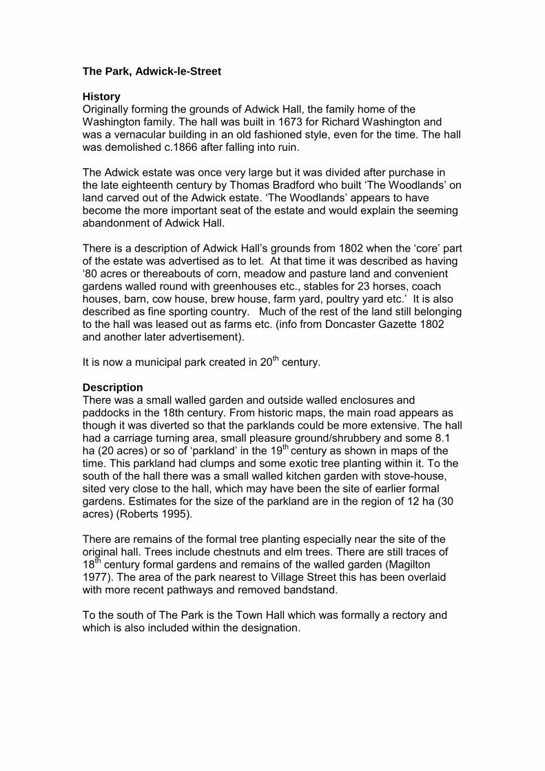
The Park, Adwick-le-Street History Originally forming the grounds of Adwick Hall, the family home of the Washington family. The hall was built in 1673 for Richard Washington and was a vernacular building in an old fashioned style, even for the time. The hall was demolished c.1866 after falling into ruin. The Adwick estate was once very large but it was divided after purchase in the late eighteenth century by Thomas Bradford who built ‘The Woodlands’ on land carved out of the Adwick estate. ‘The Woodlands’ appears to have become the more important seat of the estate and would explain the seeming abandonment of Adwick Hall. There is a description of Adwick Hall’s grounds from 1802 when the ‘core’ part of the estate was advertised as to let. At that time it was described as having ‘80 acres or thereabouts of corn, meadow and pasture land and convenient gardens walled round with greenhouses etc., stables for 23 horses, coach houses, barn, cow house, brew house, farm yard, poultry yard etc.’ It is also described as fine sporting country. Much of the rest of the land still belonging to the hall was leased out as farms etc. (info from Doncaster Gazette 1802 and another later advertisement). It is now a municipal park created in 20th century. Description There was a small walled garden and outside walled enclosures and paddocks in the 18th century. From historic maps, the main road appears as though it was diverted so that the parklands could be more extensive. The hall had a carriage turning area, small pleasure ground/shrubbery and some 8.1 ha (20 acres) or so of ‘parkland’ in the 19th century as shown in maps of the time. This parkland had clumps and some exotic tree planting within it. To the south of the hall there was a small walled kitchen garden with stove-house, sited very close to the hall, which may have been the site of earlier formal gardens. Estimates for the size of the parkland are in the region of 12 ha (30 acres) (Roberts 1995). There are remains of the formal tree planting especially near the site of the original hall. Trees include chestnuts and elm trees. There are still traces of 18th century formal gardens and remains of the walled garden (Magilton 1977). The area of the park nearest to Village Street this has been overlaid with more recent pathways and removed bandstand. To the south of The Park is the Town Hall which was formally a rectory and which is also included within the designation.

Significance The park includes the original grounds of the demolished Adwick Hall and incorporates important garden features including tree planting and garden walls. It is also important in the setting of Adwick-le-Street Conservation Area There is enough of the former landscaping to recognise the 19th century layout of the grounds of Adwick Hall which has many fine specimen trees, as well as remnants of the early 18th century garden walls. It is therefore considered to be of sufficient significance to be a park and garden of local historic interest.
Ordnance Survey - First Edition 1954

Print of old Adwick Hall (undated) showing carriage turning area


Tickhill Castle Grounds, Tickhill History Tickhill Castle started out as a motte and bailey castle build in the 11th century, and was one of the manors of Roger de Busli, Lord of Tickhill. Tickhill Castle House lies within the site and was built after the parliamentary slighting of the Castle in 1648. This process was brought about by a General Order of the House of Commons in 1647, and resulted in the keep of Tickhill Castle being pulled down to the plinth course, and the stone used to build the house (Hippisley-Cox et. al. 1985). The house was built by the Hansby family and was held by them ‘under successive leases….through the whole of the seventeenth century’ (Hunter 1828/Klemperer 2010). From 1719 until 1733, Tickhill Castle House was leased to Lord William Fitz-William, followed by Thomas Sanderson of Sandbeck. Thomas the brother of the Earl of Scarbrough, and upon the latter’s death in 1739, he moved to Sandbeck (Klemperer 2010). After Sanderson the lease was taken by the Lumley family, relatives of the Earls of Scarbrough, which they held for nearly two hundred years (Gordon-Smith 1966). The Lumley family were followed in the 20th century by the Barclay-Sheffield and Atkinson-Clarke families. The house was briefly let as a school c.1950, but had returned to a private residence by 1952. It was then let to the Gentry family, followed after a period of neglect by Mr B. Moss (Sharp 1988). Description The house itself has a hammer-dressed limestone façade, and the remainder is constructed from rubble in three storeys, with a slate roof (Pevsner 1974). It is Grade II* listed and is set within the site of the 11th Norman castle, which elsewhere is now ruinous and is designated as a scheduled monument. Thomas Sanderson of Sandbeck, during his relatively short time (1733-39) at the castle, is mainly responsible for its current appearance as he carried out ‘modernisation’ of the castle house by replacing the mullion windows with Georgian-type sashes. He conducted other substantial alterations to the house, as well as landscaping the grounds (Klemperer 2010). The house was also ‘refaced in the 18th century and the ‘gatehouse’ built in the 12th century received a similar make over (Sydes 1988). This landscaping, according to one authority, comprised of ‘cutting a walk-way around the outer face of the bailey wall… the construction of a revetment wall where the walk-way cut into the slopes of the motte, the excavation of a walk-way spiralling up to the summit of the motte, the levelling of the bailey area, the construction of a promenade along the north wall, the insertion of a doorway for access to the walk-way, and the construction of an ice house on the outside of the north wall’ (Hippisley-Cox 1958). During the latter part of the 18th century the wall on the south of the bailey was demolished to allow light into the gardens. The bailey itself forms the garden

of the house laid out in a simple 19th century style with specimen trees set in, or around, a large lawn (Jordan 1991). This area in the early 19th century is described as having ‘flower and kitchen gardens’ (Hunter 1828), and certainly there was a kitchen garden in the walled area to the north of the site (Klemperer 2010). Klemperer considers that the spiral path cut into the motte and the rebuild of the keep foundations are more in keeping with 19th century landscaping, designed to create a romantic ideal rather than 18th landscaping schemes. The motte was in the 19th century planted heavily with trees with contemporary descriptions emphasising that ‘the sides of the tumulus, on which formally stood the keep, are planted, but the upper part is plain, and from it is an agreeable view of the country towards Laughton’ (Hunter 1828). The heavy planting of the motte and the restoration of the gatehouse also add to this theme of Victorian ‘romanticism’ (Klemperer 2010). The landscaping of the motte is also noted in several other articles (accessed via googlebooks 13.3.2013) from the early 19th century as follows: ‘Within the walls, the grounds form a miniature Eden; the sloping mount is converted into winding walks overhung with the most beautiful and pendant shrubs, and the whole area is one delightful garden. From the summit of the mount the view is rich and interesting …’ The Northern Star, or Yorkshire Magazine, ed A. Jowitt, vol 1, 1817, p. 255 ‘[Tickhill Castle] seat of Hon Frederick Lumley … part of the ground within the walls is converted into gardens and shrubberies; the steep declivity of the hill is formed into winding walks, shaded with pendant wood, which afford, from various openings, views of the gardens and town below…’, The English Counties Delineated, Thos. Moule 1837, vol 2, p. 494 It may be that the garden came in to being in the 18th century as it has strong resemblance to ‘snail mounts’ of the period and echo the practice of using existing features to enhance gardens. This garden may then have been modified in the 19th century with the addition of further (tree) planting. To the east of the site lies a large 250m long ‘medieval fish pond’ (Wagner 1994) and beyond it a number of small paddocks which have been incorporated into the decorative landscape. The site’s gardens have been subject to recent neglect, and are currently grassed over (Klemperer 2010). There are also fishponds to east of castle grounds and a medieval deer park once existed beyond the grounds. Significance The park incorporates prominent landscape features including the schedule monument and tree planting. The layout of the pleasure grounds are still apparent and are strongly believed to have originated in the 18th century, with the walkway around the castle walls and the spiral walkway of the motte, which could have been modified in the 19th century.
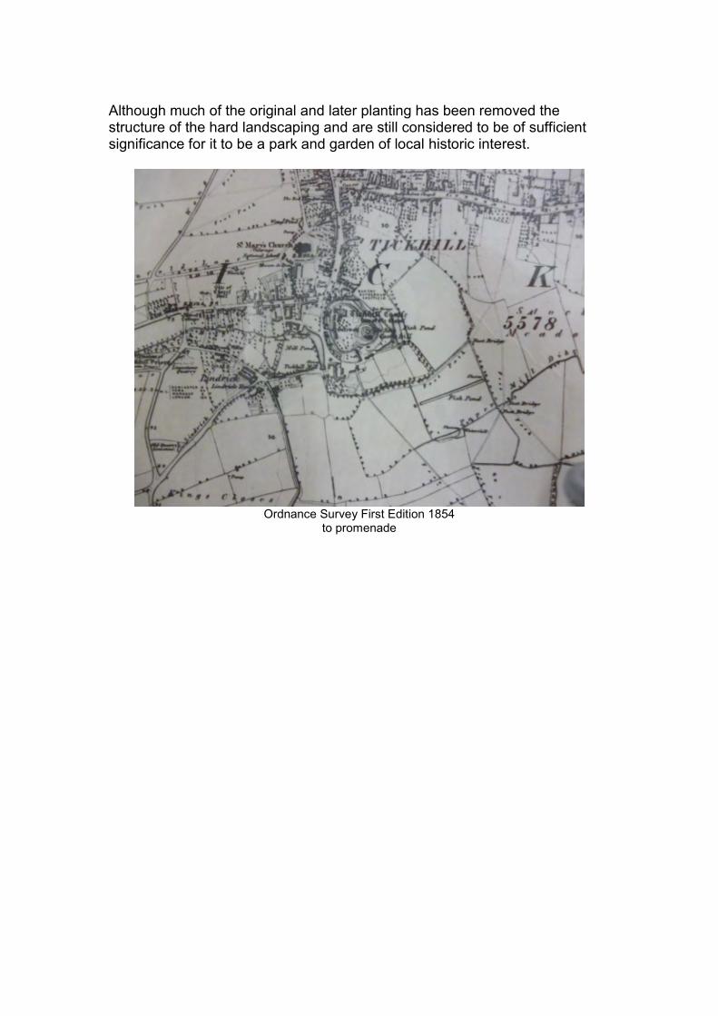
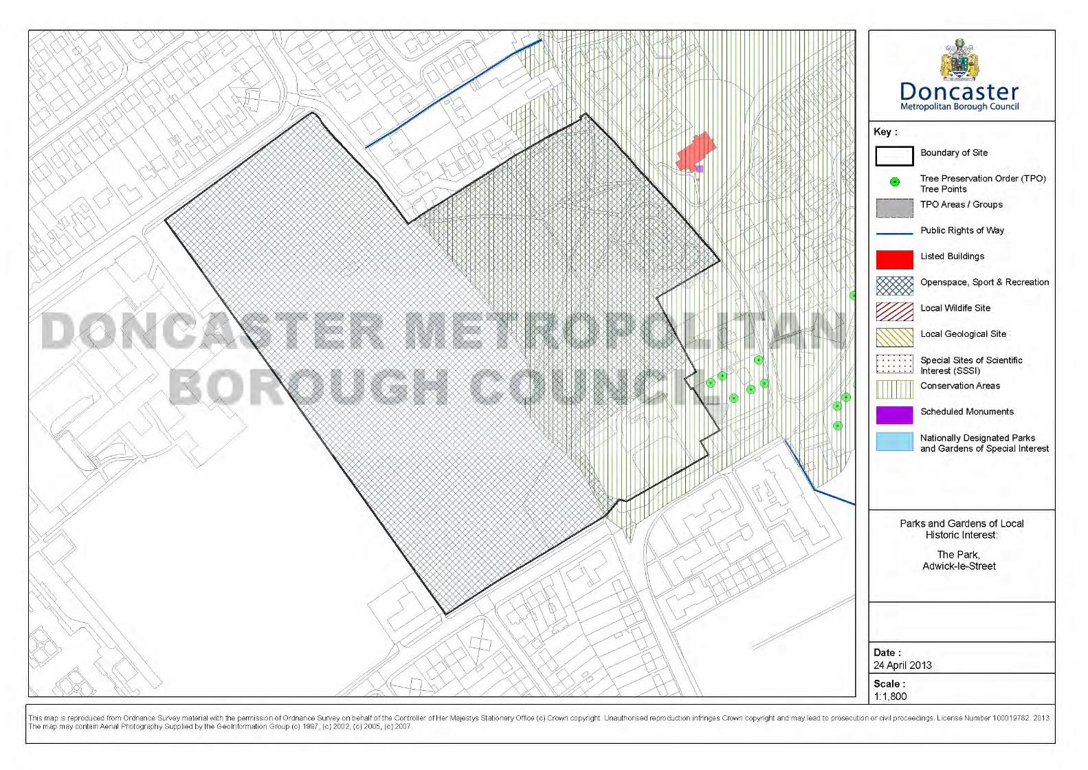
Although much of the original and later planting has been removed the structure of the hard landscaping and are still considered to be of sufficient significance for it to be a park and garden of local historic interest.
Ordnance Survey First Edition 1854
to promenade


Wadworth Hall Grounds, Wadworth History There were two houses occupying, at the same time, the site of the present Wadworth Hall, one owned by the Copley Family the other by the Pierrepoint family. The Pierrepoint property was left to Francis Battie (ob. 1682), a relative by marriage. The Battie family also had interests in Cusworth and Warmsworth and sold this property to the Arthur family. The two mansions of William Arthur and Lionel Copley at Wadworth are shown in Samuel Bucks c.1720 sketch as substantial Tudor houses (Buck 1979). These houses had a number of walled courtyards, with paths, and some small scale formal tree planting (Klemperer 2010). John Arthur sold his property to Josias Wordsworth (1691-1750) in the early 18th century and it is also likely that Wordsworth also purchased the Copley property at Wadworth when Lionel Copley inherited Sprotbrough Hall in 1709 (Girouard 1966). It was Wordsworth who proceeded to have a ‘new hall built adjoining the old one’ and gave it as a wedding gift to his son (also Josias (ob. 1780)) along with all his other Yorkshire property in 1749 (Miller 1804). This new hall seems to have replaced one of the previous two old halls whilst the other was demolished soon after with new grounds being created. The estate stayed in the Wordsworth family until 1825, since when it has been in numerous hands, mostly as a private residence but has relatively recently also been home of an architect’s practice. It is now again a private dwelling. The shrubbery was formerly part of Wadworth Hall grounds but was donated to the Woodlands Trust on the 15th December 1994 from Wadworth Hall Trust. Description Wadworth Hall was built c. 1750 by James Paine for Josias Wordsworth as a country house and is now a Grade I listed building. It is built of ashlar blocks in an elegant Palladian style with two flanking entrance pavilions (Hey 1981) of a similar date and are separately Grade II* listed. The hall, its pavilions/lodges and attached curving screen walls form a formal court to the south front of the hall which has a circular carriage turning area walls and at its centre is a sundial which again is contemporary with the hall and lodges in date and is Grade II listed. Hidden by the screen wall to the west, are a small kitchen garden and a small walled garden, the latter may have had a formal flower garden in the 18th century but which was turned into a mini-pleasure ground in the 19th century (Klemperer 2010). A number of glasshouses/conservatories were also built in the walled garden complex (Desmond 1984). None of these internal features now appear to still exist To the northwest of the hall is an area called ‘The Shrubbery’. It is situated on a north-facing slope and due to its elevated location makes it a prominent
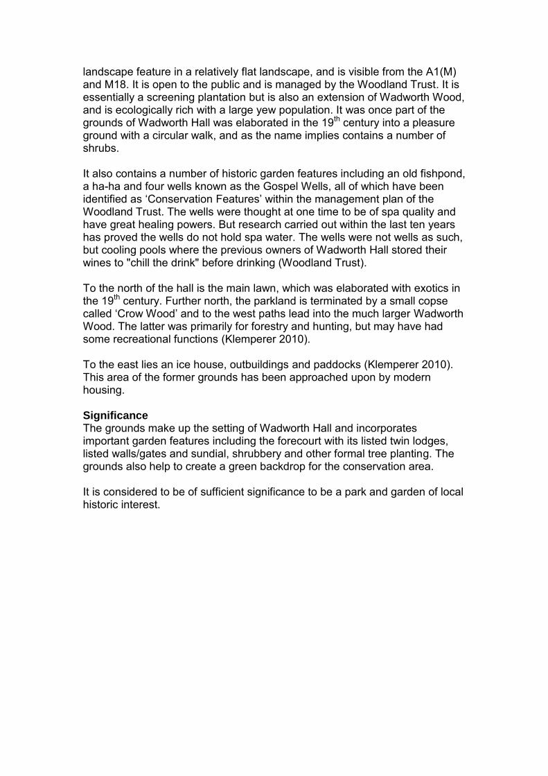
landscape feature in a relatively flat landscape, and is visible from the A1(M) and M18. It is open to the public and is managed by the Woodland Trust. It is essentially a screening plantation but is also an extension of Wadworth Wood, and is ecologically rich with a large yew population. It was once part of the grounds of Wadworth Hall was elaborated in the 19th century into a pleasure ground with a circular walk, and as the name implies contains a number of shrubs. It also contains a number of historic garden features including an old fishpond, a ha-ha and four wells known as the Gospel Wells, all of which have been identified as ‘Conservation Features’ within the management plan of the Woodland Trust. The wells were thought at one time to be of spa quality and have great healing powers. But research carried out within the last ten years has proved the wells do not hold spa water. The wells were not wells as such, but cooling pools where the previous owners of Wadworth Hall stored their wines to "chill the drink" before drinking (Woodland Trust). To the north of the hall is the main lawn, which was elaborated with exotics in the 19th century. Further north, the parkland is terminated by a small copse called ‘Crow Wood’ and to the west paths lead into the much larger Wadworth Wood. The latter was primarily for forestry and hunting, but may have had some recreational functions (Klemperer 2010). To the east lies an ice house, outbuildings and paddocks (Klemperer 2010). This area of the former grounds has been approached upon by modern housing. Significance The grounds make up the setting of Wadworth Hall and incorporates important garden features including the forecourt with its listed twin lodges, listed walls/gates and sundial, shrubbery and other formal tree planting. The grounds also help to create a green backdrop for the conservation area. It is considered to be of sufficient significance to be a park and garden of local historic interest.

Plan of Wadworth, 1767, based on the Inclosure Award Map, showing: 1) Wadworth Hall, built by Wordsworth in 1749/50 (still standing) 2) Wadworth Old Hall, owned by Godfrey Higgins, as shown in Wainwright. This is marked on later maps as Old Hall Farm
Old drawing of previous Wadworth Hall


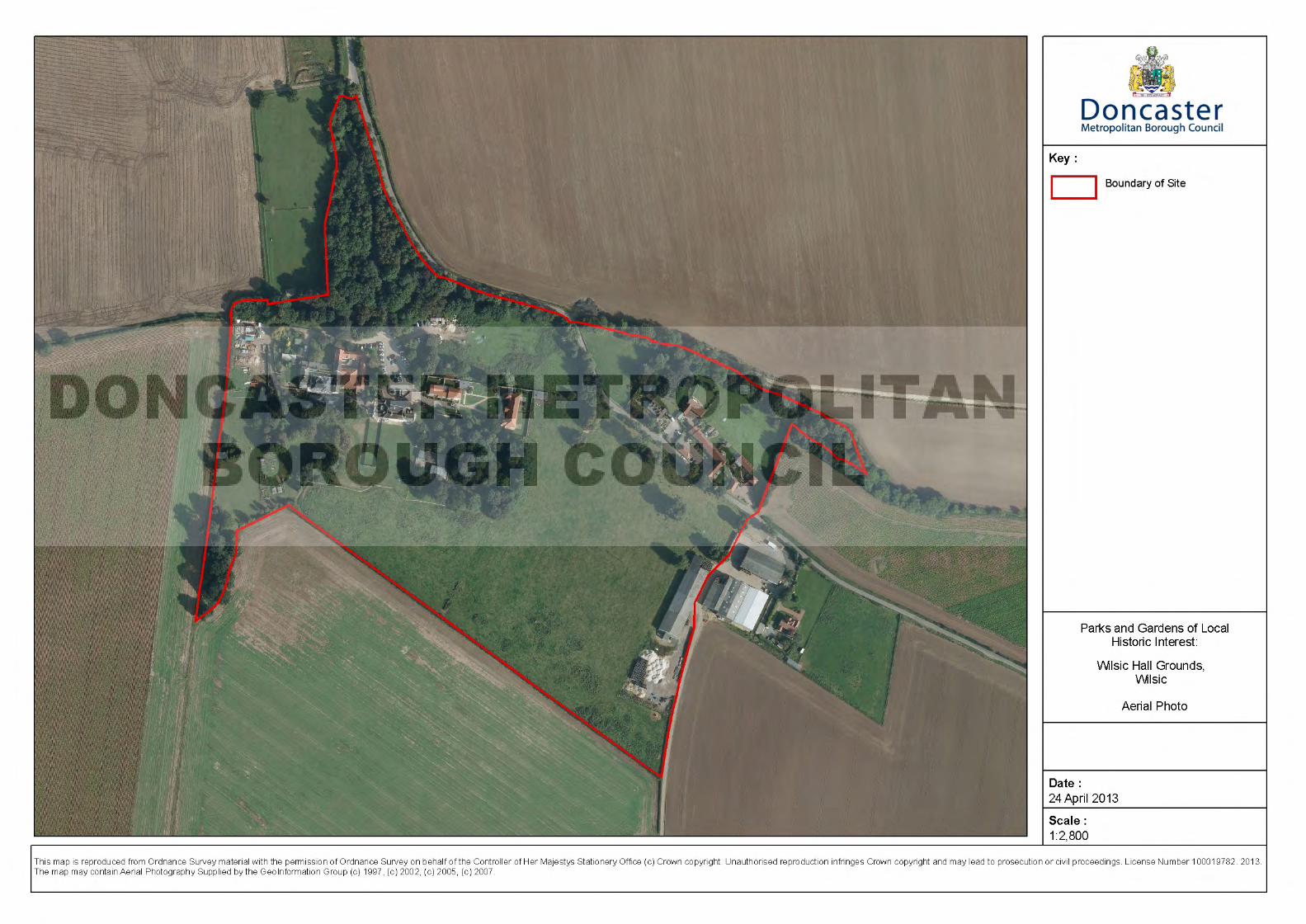
Wilsic Hall Grounds, Wilsic History The ‘manor’ of Wilsick was owned by George Copley (of Doncaster) during the reign of William and Mary. It then passed into the hands of George Withers, who lived at Wilsic until the 17th century (Hunter 1828) when it passed into the hands of the Tofield Family (Klemperer 2010). Thomas II (1695-1747) inherited the estate on the death of his father in 1717. He was also engaged in several civil engineering projects on the River Don. On his death his son, Thomas III (1730-1779), inherited and became in the course of his life a civil engineer and botanist of some note (Klemperer 2010). On his death in 1779 the property was sold on and passed through numerous different owners over the years and is now owned by the Hesley Group, a residential school for those with learning disabilities. Description The first Wilsic Manor House was probably built in Tudor times, and was certainly lived in by both George Withers in the mid17th century and by the Tofield family probably until 1741, when the new hall is thought to have been constructed (Klemperer 2010). In 1741, a loan was taken out by Thomas II Tofield, which is assumed to have paid for the rebuilding of the house, which was now of three storeys, and which still remains as the central block of the current hall. It is in rendered limestone with a hipped stone roof in a style commensurate with an early-mid 18th century (Magilton 1977) which would seem to tally with this 1741 date. Underneath this structure are the ground floor and cellars of an earlier 16th century building, which indicates that the present Wilsic Hall was built over, or was a rebuilt of the earlier hall (Klemperer 2010). The house also had Dutch Jacobean style additions, on the west and east ends in the 19th century, which are stuccoed brick. The main section of the hall on the north has an ornamental porch also from this period (Skidmore et al). It is now a Grade II listed building. The main approach to the hall is from the north. At the entrance to the driveway is a pair of gate piers (Grade II Listed). The driveway then winds through Drive Plantation, which includes 19th century exotic planting before arriving at the forecourt to the hall. Surrounding the house, is its immediate grounds of approximately two acres. This was probably a lawn with specimen tree planting in the 18th century in line with the aesthetic of the landscape park of the time. In the 19th century this area was planted with specimen exotics, particularly conifers including a Wellingtonia, to form a shrubbery or wilderness close to the hall. The grounds of the later Wilsic Hall stretch southwards and westwards into a parkland of 20ha (50 acres). This parkland is in a ‘Brownian’ mode (i.e.
mid18th century) and has a number of surviving features that put it at a date contemporary with the house’s development. These include ‘English Landscape Park’ style tight tree clumps, a ha-ha (which is grade II listed), dividing the rear lawns from the park, and perimeter plantations. The ha-ha is constructed of earth, with limestone rubble walling, and was probably built in the mid18th century as a means of stock control. To the west of the parkland, a small stream flowed, and the Tofields constructed a number of ponds along its course, almost like a serpentine river (Klemperer 2010). In the 19th century, a number of plantations were made within the parkland to provide cover for game, including Out Moor Holt, Batty Holt, Ant Wood, Ash Holt, Crow Plantation, and the above mentioned Drive Plantation. Another of these plantations, Wadworth Plantation, forms the backcloth of the nearby home farm. Many have remnants of larch and Scots Pine that were thought ideal as habitats for pheasant. Also in the 19th century the carriageway from Stainton Lane, in the south was equipped with a lodge (Wilsic Lodge), in line with similar developments in other estates of the area. The kitchen garden lies directly to the northeast of the property, and it is this proximity that indicates an early 18th century date. In the mid18th century the kitchen gardens of the houses of the fashionable gentry were placed at more remote locations. It is unlikely that the Tofields were not rich, or fashionable enough to ascribe to this practice, given the quality of the later 18th century landscape elsewhere on the site. Within the kitchen garden’s walls there was in 2001 the remains a decorative alcove, perhaps for a seat, which is of unknown date. There are modern developments within this area. Lengths of stone walling, stretching northwest towards the stream, indicate some of the paddocks, or perhaps an orchard/garden of the previous manor house (Klemperer 2010). There is also evidence of a Deserted Medieval Village and it is possible that the expansion of the hall’s holding in the 17th and 18th centuries led to its destruction. Significance The grounds make up the setting of Wilsic Hall and incorporates important garden features including the entrance gates, drive, ha-ha and woodlands. It was also the home of Thomas Tofield, botanist & civil engineer. Although the original grounds are now in different ownership and a hedgerow diagonally cuts across the parkland it is still considered to be of sufficient significance to be a park and garden of local historic interest.

Woodlands Hall Grounds and Highfields Country Park, Woodlands History The Woodlands (latterly known as Woodlands Hall) was built in the late 18th century for Thomas Bradford as a country house, and is said to have been designed by William Lindley of Doncaster. Bradford was a member of the Doncaster Corporation and had purchased the Adwick le Street estate from Charles Duncombe. Bradford divided the estate, selling the house at Adwick – le –Street and part of the land to George Wroughton and the rest he kept to become The Woodlands estate. The resulting estate at Woodlands with a relatively small plot, probably of around 16ha (40 acres) (Hunter 1828). Bradford may have been something of a land speculator for soon after building Woodlands in the late 18th century he sold it to Christopher Waterton Esq (Klemperer 2010). Waterton extended the estate by buying land from Sir George Cooke, a member of the Cooke family from Wheatley. The purchase included Hanging Wood to the south of the property, which more than doubled the estate at Woodlands to more than 32ha (80 acres) (Klemperer 2010).The hall was occupied by Thomas Walker (ob. 1891), a magistrate, in the 1880s, and constructed the model farm buildings on the estate (Tuffrey 2000). It was subsumed into the Brodsworth Hall Estate and at the beginning of the 20th century the northern part of the grounds were developed and laid out with colliery housing as Woodlands Garden Village (which is now Woodlands Conservation Area). The park later became a public park for this village, as well as the nearby Highfields, and is now known as Highfields Country Park through which the course of a former railway runs. Woodlands Hall is used as a Working Men Club and retains the grounds of its approach. Description The mansion of Woodlands was built at the end of the 18th century by Thomas Bradford. Bradford’s building was in 3 storeys, built of red brick, with a central range, pedimented front, and with two storey side wings (Magilton 1977) and is now a Grade II Listed building. It is on the Magnesian Limestone ridge. There is a carriage turning area to its northeast front, with approaches from the Great North Road through a dense and deep plantation. To the southeast is a lawned area, once used for croquet but now used as a bowling green, beyond which is a ha-ha separating it from the wider landscape. The hall has walled, formal and kitchen gardens to its south (Klemperer 2010). Beyond the ha-ha, the grounds are divided into parkland to the east, southwest and northwest, and with Hanging Wood defining the estate to the south. Separating the parkland to the east and Hanging Wood is a large ‘Fish Pond’, fed by Underhills drain in a serpentine shape with two weirs to affect some flow. The lake has an island, planted with trees, and a boat house. The parkland itself is loosely planted, with Picturesque clumps and is bounded on all sides by linear shelter belts. In the 19th century the grounds were extensively planted with coniferous specimen trees. The Pickburn (horse)

training grounds to the southwest and west were screened by the Tithe Barn plantation (Klemperer 2010). Through the northern edge of Hanging Wood runs the winding course of the old railway which is now a footpath. In the later 19th and into the 20th century, the landscape to the north was extensively changed by the building of the Woodlands model (mining) village, for Brodsworth Colliery, and this now surrounds the area on three sides. Significance The grounds make up the wider setting of Woodlands Hall and incorporates important garden features including the stream/lake and woodlands. The original landscape of the hall can be appreciated and it is therefore considered to be of sufficient significance to be a park and garden of local historic interest.
Ordnance Survey First Edition 1854


Wyndthorpe Hall Grounds, Dunsville History The hall was originally built in the early 19th century by the Wright family and was originally called Park Lane Hall. Its late adoption as a suitable site for building may have some connection with its very flat aspect and low height above sea-level. The site was marshy until drained in the late 18th century which enabled the area to be farmed (Coates 1960/Klemperer 2010). Lord Chetwynd rented the mansion from 1901, and later bought it in 1906 (Klemperer 2010). He changed its name to Wyndthorpe which incorporated part of his family name within it. It was sold to the Mutual Co-operative Society in 1919 who established a dairy farm there (Tuffrey 2000). After the Second World War, the hall was bought by the West Riding Council and used as a children’s home (Klemperer 2010). It is now a private nursing home and bowling club. Description Wyndthorpe Hall is a Grade II listed building. The Hall itself dates from the early nineteenth century. It is in stucco with a slate roof. It frontage is elaborated with a Central recess with glazed double doors in architrave flanked by tall Ionic columns. The landscaping around the building comprises of formal gardens around the house, with a lawn sloping down to the parkland to the southwest, which is contemporary with the date of the building. To the east of the hall lies a walled kitchen garden with a glasshouse surrounded by small pleasure grounds, which stretch round to the northwest front of the hall (Klemperer 2010). The hall is approached along a winding driveway through a plantation of trees and the building is set within grounds that retain elements from 19th century maps. These include tree belts to the west and south-east. The entrance to this main approach is marked by remnants of gate piers but does not appear to ever have had a lodge. The parkland has informal groups of deciduous trees and is bounded by plantations, around its edge of mixed woodland. To the east is a small lake called Pike Pool, which is fed by a small stream, running through woodland, which was turned into a landscaping feature (Klemperer 2010). To the northeast corner lies what appears to have originally been the stables to the hall. These are part of a cluster of 19th century buildings that are connected with the estate, such as Park Lane Cottages and Park Lane Farm (Klemperer 2010). Significance The grounds make up the setting of Wyndthorpe Hall and incorporates important garden features including the drive, woodlands and pond.

It is therefore considered to be of sufficient significance to be a park and garden of local historic interest.