The Palenque Mapping Project, 1999 Field Season Report · The Palenque Mapping Project, 1999 Field...
45
FAMSI © 2000: Edwin L. Barnhart The Palenque Mapping Project, 1999 Field Season Report Research Year: 1999 Culture: Maya Chronology: Classic Location: Chiapas, México Site: Palenque Table of Contents The Palenque Mapping Project: 1999 Field Season Report Introduction Methodology Survey/Mapping Structure Designation Discussions by Group Group J West The Motiepa East Group The Motiepa Group Moises’ Retreat Group G The Xinil Pa’ Group The Piedras Bolas Group The Olvidado Group The Picota Group The Lemon Group
Transcript of The Palenque Mapping Project, 1999 Field Season Report · The Palenque Mapping Project, 1999 Field...

FAMSI © 2000: Edwin L. Barnhart
The Palenque Mapping Project, 1999 Field Season Report
Research Year: 1999 Culture: Maya Chronology: Classic Location: Chiapas, México Site: Palenque
Table of Contents
The Palenque Mapping Project: 1999 Field Season Report Introduction
Methodology Survey/Mapping Structure Designation
Discussions by Group Group J West The Motiepa East Group The Motiepa Group Moises’ Retreat Group G The Xinil Pa’ Group The Piedras Bolas Group The Olvidado Group The Picota Group The Lemon Group

2
The Nauyaka Group The Escondido Group
Summation Sources Cited
Architectural Analysis in Western Palenque by James Eckhardt and Heather Hurst Palenque’s Water Management by Kirk D. French
The Palenque Mapping Project: 1999 Field Season Report
Introduction
This report covers the results of the 1999 survey of Palenque’s western region, an area stretching from the Motiepa River to the structures around the Picota River (Map 1). Discussions of Palenque’s central region, between the Motiepa and Otulum Rivers, can be found in the PMP 1998 Report. A total of 635 structures were encountered during the survey. Added to the 1998 total of 403, a grand total of 1038 structures have now been documented and placed on the map. Compared to the 107 structures recorded to the west of the Motiepa River on M.G. Robertson’s map (1983), a total of 528 structures are presented for the first time in this report. The majority of Palenque’s western settlement was built upon a flat, east-west running plateau, the same plateau utilized by the structures of Palenque’s central precinct. Further settlement extends above and below the plateau, built upon platforms and massive terraces protruding from the hillsides. The areas around the Motiepa, Piedras Bolas and Picota Rivers are densely covered with small residential structures. All three rivers contain evidence of water management architecture. Furthest west, around the Picota River, the constructions are larger and appear to be public spaces. Features including the Olvidado Temple, two temples directly to the west of the Olvidado, the Picota Complex (plaza, aqueduct and stela), and the newly documented Escondido Platform combine to create the impression that a second "center" existed at Palenque. This newly recognized "center" and the residential areas between it and Palenque’s primary center will be discussed in the sections that follow.
Submitted 11/01/1999 by: Edwin L. Barnhart

3
Methodology
Survey/Mapping
The survey methodology was designed to achieve 100% coverage of the project area. Computer software allowed the survey crew to have daily-generated maps of what they covered and which areas needed further documentation. Water-resistant notebooks were used to record the data and accompanying field sketches. The survey instrument, a GTS-211D total station on loan from the Topcon Corporation, records data points by bouncing light off a movable prism. The prism is placed in a desired location and the instrument records its position in reference to its own. Locations where the instrument was set up were given individual station numbers and marked with five-inch steel nails. Each new station was established by sighting it from the prior station. The crew moved the instrument in loops of stations, regularly returning to previously established locations in order to monitor and control the accumulation of error.
The data entered from the survey was recorded as three-dimensional points, one for each shot taken in the field. Those 3-D points were then manipulated in Foresight, a professional survey software package, to create a map of contour lines and structure footprints. This process allowed the map to be field checked as it was generated,
4
ensuring accuracy and completeness. At the conclusion of the season, the Foresight file was transferred to AutoCAD, computer aided drafting software, and combined with digital architectural drawings to create the final maps.
The coordinate grid begun in the 1998 season was expanded as the survey continued out. The grid’s point of origin, designated 8000N, 8000E, is located on the west side of the Temple of the Cross. Its location was chosen to link with a small grid of benchmarks placed in the Cross Group by INAH archaeologist Rosalva Nieto in the 1980’s. New benchmarks have been and will continue to be placed in outlying groups as an aid to future investigations at Palenque.
Structure Designation
Each structure encountered during survey must be given a designation. In the case of Palenque, this presents a methodological problem. The major structures of the site already have designations, mostly roman numeral. The groups of the periphery, however, were named during different projects resulting in a mixing of designation systems. Some groups have received more than one designation, creating confusion in the literature. The task of the PMP is to use a designation system that does not require changing existing names and at the same time builds upon an existing system. It was decided that going with the oldest, most expansive designation system is the best solution. The first project to map Palenque’s periphery was in the 1920’s, conducted by Franz Blom. His system was to identify peripheral structures by group, giving each group an alphabetic designation. Eventually, they became known as Blom’s Groups A through J. The PMP chose to build from the Blom’s Group system, designating each structure with a letter reflecting its group affiliation and a number individualizing it within the group. For outer groups that neither Blom nor Robertson clearly identified, new group names were assigned.
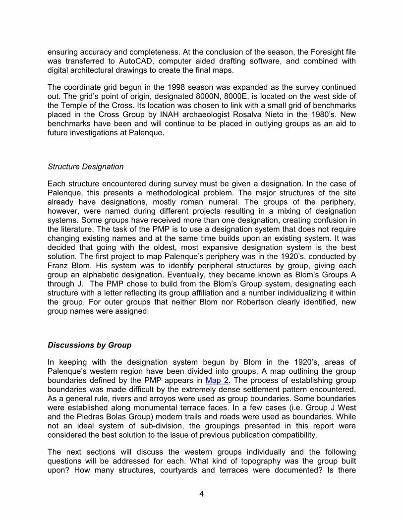
Discussions by Group
In keeping with the designation system begun by Blom in the 1920’s, areas of Palenque’s western region have been divided into groups. A map outlining the group boundaries defined by the PMP appears in Map 2. The process of establishing group boundaries was made difficult by the extremely dense settlement pattern encountered. As a general rule, rivers and arroyos were used as group boundaries. Some boundaries were established along monumental terrace faces. In a few cases (i.e. Group J West and the Piedras Bolas Group) modern trails and roads were used as boundaries. While not an ideal system of sub-division, the groupings presented in this report were considered the best solution to the issue of previous publication compatibility.
The next sections will discuss the western groups individually and the following questions will be addressed for each. What kind of topography was the group built upon? How many structures, courtyards and terraces were documented? Is there
5
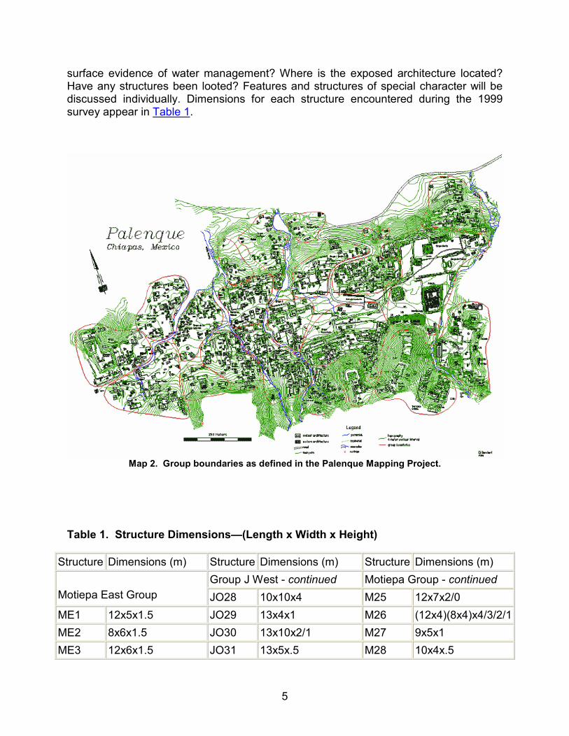
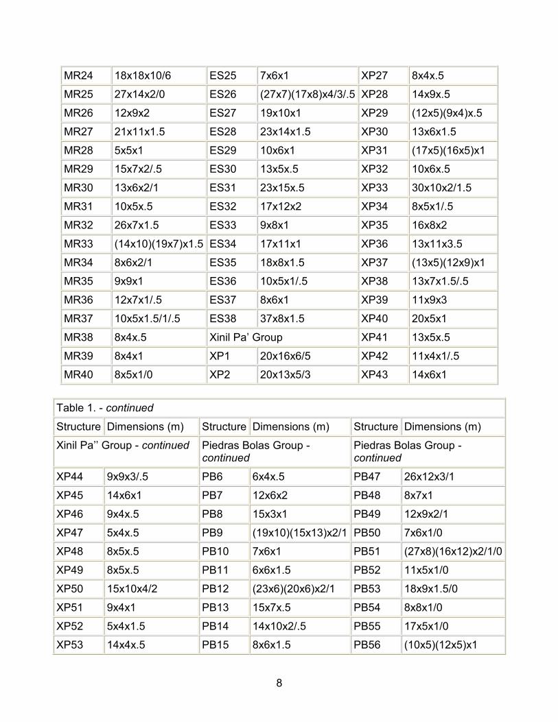
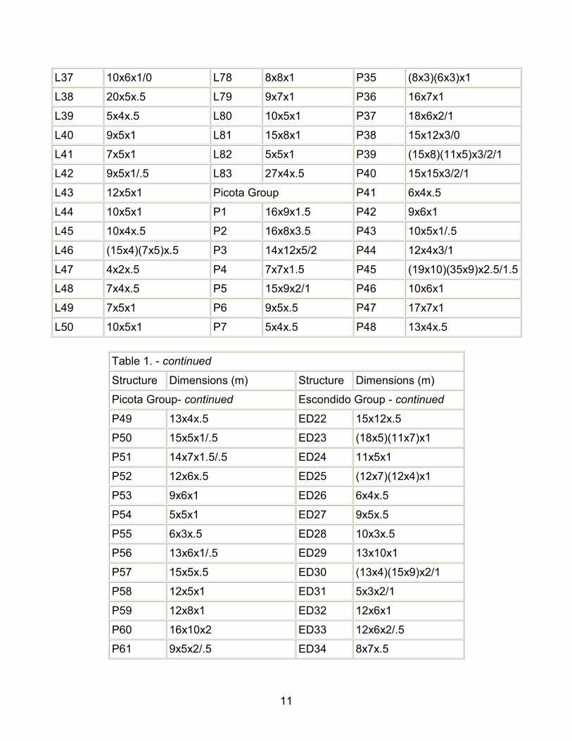
surface evidence of water management? Where is the exposed architecture located? Have any structures been looted? Features and structures of special character will be discussed individually. Dimensions for each structure encountered during the 1999 survey appear in Table 1.
Map 2. Group boundaries as defined in the Palenque Mapping Project.
Table 1. Structure Dimensions—(Length x Width x Height)
Structure Dimensions (m) Structure Dimensions (m) Structure Dimensions (m)
Group J West - continued Motiepa Group - continued
Motiepa East Group JO28 10x10x4 M25 12x7x2/0
ME1 12x5x1.5 JO29 13x4x1 M26 (12x4)(8x4)x4/3/2/1
ME2 8x6x1.5 JO30 13x10x2/1 M27 9x5x1
ME3 12x6x1.5 JO31 13x5x.5 M28 10x4x.5

6
ME4 11x6x3.5/.5 JO32 8x8x1 M29 6x6x2/1
ME5 8x5x1.5 JO33 (22x8)(17x15)x2/1 M30 19x8x3/2
ME6 10x5x1 JO34 9x6x1/.5 M31 12x8x2/1
ME7 5x5x.5 JO35 (12x4)(9x4)x.5 M32 22x9x1
ME8 10x4x.5 JO36 12x7x1/.5 M33 7x7x2
ME9 6x4x1 JO37 19x8x1 M34 18x10x2/1
ME10 8x5x1 JO38 8x4x1/.5 M35 10x5x1
ME11 8x6x1 JO39 5x5x.5 M36 12x7x1.5/.5
ME12 18x6x2/1 JO40 12x6x1 M37 10x4x1
Group J West JO41 9x4x1/0 M38 10x5x1
JO1 12x4x1.5/.5 JO42 9x5x.5 M39 10x5x1
JO2 12x5x1/0 JO43 7x2x.5 M40 12x5x1
JO3 20x5x1 Motiepa Group M41 9x5x1
JO4 13x4x.5 M1 10x5x1 M42 10x5x1
JO5 5x5x.5 M2 (25x9)(20x15)x5/3/2 M43 12x5x1
JO6 22x7x2 M3 9x6x2/.5 M44 4x2x.5
JO7 (14x6)(10x5)x2/1 M4 18x4x.5 M45 4x2x.5
JO8 11x4x.5 M5 13x7x3/2 Group G
JO9 11x5x.5 M6 9x6x1/0 G1 12x12x1/.5
JO10 9x4x.5 M7 10x6x2/1 G2 12x5x.5
JO11 12x5x2/1 M8 (20x16)(7x6)x2/.5 G3 16x8x5/2
JO12 (31x10)(27x11)x3/2 M9 14x10x3/.5 G4 7x5x2/.5
JO13 10x7x1 M10 11x7x2 G5 12x4x.5
JO14 4x4x1 M11 (18x7)(17x7)x3/2/1 G6 12x7x1
JO15 18x5x1 M12 9x7x2/1 G7 6x4x2/1
JO16 7x5x1 M13 6x5x2/1 G8 8x5x1
JO17 12x6x2/0 M14 8x5x2/1 G9 10x5x1/.5
JO18 15x7x1 M15 18x4x.5 G10 6x4x2/1
JO19 29x14x3.5 M16 (13x4)(8x3)x.5 G11 10x5x1
JO20 10x5x1 M17 12x9x3/2 G12 28x24x4/2
JO21 24x4x.5 M18 12x9x2/1 G13 8x4x.5
JO22 19x9x3/1 M19 8x5x1 G14 7x4x.5
JO23 15x10x5/3 M20 7x4x.5 G15 19x5x1
JO24 (12x8)(12x5)x2 M21 14x6x2/1 G16 (27x12)(12x12)x.5

7
JO25 10x10x1 M22 9x5x1/0 G17 6x4x.5
JO26 18x8x2/.5 M23 10x5x2/0 G18 4x3x1
JO27 8x5x2/1 M24 14x8x3/0 G19 15x7x.5
Table 1. - continued
Structure Dimensions (m) Structure Dimensions (m) Structure Dimensions (m)
Moises’ Retreat - continued Xinil Pa’ Group - continued
Moises’ Retreat MR41 21x8x1/.5 XP3 13x8x3/1.5
MR1 13x5x1 MR42 10x8x1/0 XP4 7x4x.5
MR2 10x6x2/1 MR43 13x10x.5 XP5 12x5x.5
MR3 16x7x3/1 MR44 8x6x1 XP6 10x5x.5
MR4 25x13x3/2/1 MR45 7x4x.5 XP7 (13x5)(11x7)x2/1
MR5 9x5x1 MR46 9x4x1 XP8 (8x5)(8x5)x.5
MR6 (15x6)(12x4)x1 MR47 13x5x.5 XP9 18x6x.5
MR7 18x10x5x.5 MR48 14x5x.5 XP10 6x5x1.5/1
MR8 (26x12x5)x1 MR49 12x7x1.5/.5 XP11 8x5x1.5/1
MR9 25x10x1.5/.5 MR50 (12x6)(9x5)x2/1 XP12 (18x4)(9x5)x1/.5
MR10 20x5x1 MR51 12x5x1 XP13 14x7x1.5
MR11 (25x10)(16x7)x2/1 MR52 25x15x1/.5 XP14 14x7x2/.5
MR12 16x6x1 MR53 15x6x.5 XP15 18x8x1
MR13 7x4x.5 MR54 16x6x1.5 XP16 5x5x.5
MR14 26x6x1/.5 MR55 13x5x1 XP17 9x6x1
MR15 10x4x1 MR56 12x5x1/.5 XP18 32x18x2
MR16 15x6x1/.5 MR57 19x10x.5 XP19 5x4x1.5
MR17 (10x4)(8x5)x1 MR58 11x5x1 XP20 7x7x.5
MR18 12x5x1 MR59 20x6x1 XP21 7x3x1.5
MR19 13x6x1 MR60 12x4x.5 XP22 8x5x.5
MR20 13x5x1 MR61 10x7x.5 XP23 17x8x1.5
MR21 9x9x5/4 Encantado South- continued XP24 8x5x1
MR22 (14x5)(7x4)x1.5/.5 ES23 12x7x.5 XP25 15x7x.5
MR23 10x5x1 ES24 12x12x4/.5 XP26 (10x4)(8x4)x.5
8
MR24 18x18x10/6 ES25 7x6x1 XP27 8x4x.5
MR25 27x14x2/0 ES26 (27x7)(17x8)x4/3/.5 XP28 14x9x.5
MR26 12x9x2 ES27 19x10x1 XP29 (12x5)(9x4)x.5
MR27 21x11x1.5 ES28 23x14x1.5 XP30 13x6x1.5
MR28 5x5x1 ES29 10x6x1 XP31 (17x5)(16x5)x1
MR29 15x7x2/.5 ES30 13x5x.5 XP32 10x6x.5
MR30 13x6x2/1 ES31 23x15x.5 XP33 30x10x2/1.5
MR31 10x5x.5 ES32 17x12x2 XP34 8x5x1/.5
MR32 26x7x1.5 ES33 9x8x1 XP35 16x8x2
MR33 (14x10)(19x7)x1.5 ES34 17x11x1 XP36 13x11x3.5
MR34 8x6x2/1 ES35 18x8x1.5 XP37 (13x5)(12x9)x1
MR35 9x9x1 ES36 10x5x1/.5 XP38 13x7x1.5/.5
MR36 12x7x1/.5 ES37 8x6x1 XP39 11x9x3
MR37 10x5x1.5/1/.5 ES38 37x8x1.5 XP40 20x5x1
MR38 8x4x.5 Xinil Pa’ Group XP41 13x5x.5
MR39 8x4x1 XP1 20x16x6/5 XP42 11x4x1/.5
MR40 8x5x1/0 XP2 20x13x5/3 XP43 14x6x1
Table 1. - continued
Structure Dimensions (m) Structure Dimensions (m) Structure Dimensions (m)
Xinil Pa’’ Group - continued Piedras Bolas Group -continued
Piedras Bolas Group -continued
XP44 9x9x3/.5 PB6 6x4x.5 PB47 26x12x3/1
XP45 14x6x1 PB7 12x6x2 PB48 8x7x1
XP46 9x4x.5 PB8 15x3x1 PB49 12x9x2/1
XP47 5x4x.5 PB9 (19x10)(15x13)x2/1 PB50 7x6x1/0
XP48 8x5x.5 PB10 7x6x1 PB51 (27x8)(16x12)x2/1/0
XP49 8x5x.5 PB11 6x6x1.5 PB52 11x5x1/0
XP50 15x10x4/2 PB12 (23x6)(20x6)x2/1 PB53 18x9x1.5/0
XP51 9x4x1 PB13 15x7x.5 PB54 8x8x1/0
XP52 5x4x1.5 PB14 14x10x2/.5 PB55 17x5x1/0
XP53 14x4x.5 PB15 8x6x1.5 PB56 (10x5)(12x5)x1

9
XP54 7x5x1 PB16 8x5x1 PB57 13x8x1.5/.5
XP55 15x7x2/1 PB17 9x6x1/.5 PB58 10x6x2/.5
XP56 5x5x.5 PB18 14x7x2/1 PB59 16x11x2/.5
XP57 11x11x1 PB19 8x6x.5 PB60 24x7x1
XP58 (22x8)(17x12)x2.5 PB20 9x5x.5 PB61 10x5x1
XP59 (19x5)(11x7)x2 PB21 12x9x.5 PB62 4x4x.5
XP60 13x7x3/2 PB22 26x5x.5 PB63 12x6x1
XP61 26x13x3/2/1 PB23 13x9x2/0 PB64 10x5x1
XP62 5x4x.5 PB24 6x6x1.5/0 PB65 14x8x2/0
XP63 8x5x2/.5 PB25 20x7x1/0 PB66 9x4x1.5/0
XP64 8x6x.5 PB26 20x13x2/1 PB67 35x9(7)x1.5/0
XP65 (14x6)(9x6)x1 PB27 10x7x1/0 Olvidado Group
XP66 10x10x2/1 PB28 (16x8)(9x6)x3/2/1 O1 5x5x1
XP67 (25x4)(9x4)x1 PB29 31x10x1 O2 11x5x1
XP68 9x4x.5 PB30 9x8x1 O3 8x6x2/1.5
XP69 (24x8)(14x9)x2/0 PB31 7x5x.5 O4 6x4x.5
XP70 10x10x1.5/0 PB32 (13x9)(10x7)x2/1 O5 9x6x1.5/.5
XP71 9x4x1 PB33 15x8x1.5 O6 17x10x2/1
XP72 (22x9)(16x10)x3/0 PB34 20x20x2/.5 O7 12x7x2/.5
XP73 (21x4)(11x8)x.5 PB35 16x6x3/2/1.5 O8 16x6x2/.5
XP74 9x5x.5 PB36 5x3x1 O9 7x5x1
XP75 8x5x.5 PB37 14x8x2/.5 Lemon Group
XP76 7x5x1/0 PB38 20x12x2/0 L1 14x10x3/2
XP77 12x6x1.5/0 PB39 20x10x2 L2 8x6x2/1.5
XP78 14x7x2/0 PB40 7x4x.5 L3 6x6x1.5
Piedras Bolas Group PB41 7x4x.5 L4 (21x6)(13x6)x1
PB1 15x10x4/2 PB42 11x3x1 L5 7x4x.5
PB2 17x5x1 PB43 7x5x.5 L6 11x7x1/.5
PB3 9x6x1.5/.5 PB44 10x5x.5 L7 (17x5)(15x8)x2/1
PB4 12x10x3/1 PB45 21x6x1 L8 9x5x1
PB5 10x10x2/0 PB46 10x9x1 L9 9x4x.5

10
Table 1. - continued
Structure Dimensions (m) Structure Dimensions (m) Structure Dimensions (m)
Lemon Group - continued Lemon Group - continued Picota Group - continued
L10 6x4x.5 L51 13x5x1 P8 22x12x2/1/0
L11 13x6x1 L52 10x5x.5 P9 9x8x1.5x.5
L12 8x4x.5 L53 14x7x.5 P10 16x5x1/0
L13 14(13)x6x1 L54 10x7x1.5 P11 14x9x2/1
L14 8x4x.5 L55 (6x4)(10x4)x1.5 P12 17x5x1
L15 12x4x.5 L56 11x5x1 P13 14x14x4/2
L16 10x8x.5 L57 7x4x.5 P14 15x14x8/3/1
L17 13x6x2/.5 L58 (17x5)(17x5)x.5 P15 20x10x2/1
L18 5x4x1.5/.5 L59 10x7x.5 P16 11x7x1.5/0
L19 9x7x3/2/1 L60 12x8x1 P17 9x9x2/0
L20 17x14x2/1 L61 (18x5)(5x4)x.5 P18 18x5x1/0
L21 13x6x1 L62 11x7x1.5/1 P19 9x5x.5
L22 7x7x1 L63 13x7x1.5 P20 12x10x1
L23 5x3x.5 L64 10x7x1 P21 6x4x.5
L24 7x4x.5 L65 8x5x.5 P22 10x5x.5
L25 5x3x.5 L66 13x5x.5 P23 17x9x2
L26 (28x8)(22x21)x3/2/1 L67 28x14x4 P24 12x8x1.5
L27 9x6x1 L68 28x10x1 P25 20x12x1
L28 10x5x1/.5 L69 12x4x.5 P26 (40x15)(26x17)x3/1
L29 13x5x.5 L70 6x4x.5 P27 21x12x2/1
L30 11x6x.5 L71 4x4x.5 P28 11x5x1
L31 15x5x1 L72 13x10x2 P29 9x4x1
L32 12x4x.5 L73 13x5x1 P30 12x10x1.5/0
L33 15x10x1/.5 L74 15x10x1.5 P31 15x10x2
L34 8x5x.5 L75 6x4x1 P32 12x7x1
L35 10x4x.5 L76 10x7x1/.5 P33 25x12x2/1
L36 12x6x.5 L77 (19x6)(16x6)x1.5 P34 10x6x1/.5
11
L37 10x6x1/0 L78 8x8x1 P35 (8x3)(6x3)x1
L38 20x5x.5 L79 9x7x1 P36 16x7x1
L39 5x4x.5 L80 10x5x1 P37 18x6x2/1
L40 9x5x1 L81 15x8x1 P38 15x12x3/0
L41 7x5x1 L82 5x5x1 P39 (15x8)(11x5)x3/2/1
L42 9x5x1/.5 L83 27x4x.5 P40 15x15x3/2/1
L43 12x5x1 Picota Group P41 6x4x.5
L44 10x5x1 P1 16x9x1.5 P42 9x6x1
L45 10x4x.5 P2 16x8x3.5 P43 10x5x1/.5
L46 (15x4)(7x5)x.5 P3 14x12x5/2 P44 12x4x3/1
L47 4x2x.5 P4 7x7x1.5 P45 (19x10)(35x9)x2.5/1.5
L48 7x4x.5 P5 15x9x2/1 P46 10x6x1
L49 7x5x1 P6 9x5x.5 P47 17x7x1
L50 10x5x1 P7 5x4x.5 P48 13x4x.5
Table 1. - continued
Structure Dimensions (m) Structure Dimensions (m)
Picota Group- continued Escondido Group - continued
P49 13x4x.5 ED22 15x12x.5
P50 15x5x1/.5 ED23 (18x5)(11x7)x1
P51 14x7x1.5/.5 ED24 11x5x1
P52 12x6x.5 ED25 (12x7)(12x4)x1
P53 9x6x1 ED26 6x4x.5
P54 5x5x1 ED27 9x5x.5
P55 6x3x.5 ED28 10x3x.5
P56 13x6x1/.5 ED29 13x10x1
P57 15x5x.5 ED30 (13x4)(15x9)x2/1
P58 12x5x1 ED31 5x3x2/1
P59 12x8x1 ED32 12x6x1
P60 16x10x2 ED33 12x6x2/.5
P61 9x5x2/.5 ED34 8x7x.5

12
P62 12x11x1 ED35 8x5x1
P63 12x5x3/1 ED36 8x6x1
P64 12x6x.5 ED37 13x11x2/1
P65 (8x4)(10x4)x1 ED38 (12x8)(8x4)x2/1
P66 15x5x1 ED39 31x9x2/0
P67 8x6x2/1 ED40 18x5x1
Escondido Group ED41 20x12x2/1
ED1 (20x7)(13x7)x1.5 ED42 12x7x1
ED2 16x8x1.5 ED43 9x5x.5
ED3 9x5x1 ED44 5x4x.5
ED4 11x6x1 ED45 (25x5)(10x7)x2/1
ED5 (30x5)(28x5)(15x6)x.5 ED46 7x5x1.5
ED6 15x5x1 ED47 (16x7)(14x9)x1
ED7 8x7x2/1 ED48 16x6x2/1
ED8 7x6x1 ED49 10x5x1.5/.5
ED9 10x8x1 ED50 10x10x.5
ED10 9x6x2/1 ED51 12x10x1
ED11 12x8x2/1 ED52 (30x8)(10x5)x2/1
ED12 6x4x.5 ED53 (13x7)(11x5)x1.5
ED13 4x3x.5 ED54 (18x5)(14x5)x1.5/1
ED14 10x5x1.5 ED55 9x5x1
ED15 (31x12)(21x8)x2/1 ED56 17x5x.5
ED16 6x4x1 ED57 (14x6)(10x5)x2/1
ED17 (14x10)(19x7)x1 ED58 11x5x1
ED18 12x5x1 ED59 5x5x1
ED19 10x9x1 ED60 9x2x.5
ED20 22x10x1
ED21 8x4x.5
Table 1. - continued
Structure Dimensions (m) Structure Dimensions (m)

13
Nauyaka Group N40 10x6x.5
N1 10x5x.5 N41 12x10x2
N2 10x5x.5 N42 16x12x3/2/1
N3 12x6x.5 N43 18x7x2.5/1
N4 15x5x2/1 N44 10x6x.5
N5 12x5x.5 N45 12x7x1.5
N6 16x7x2/1/.5 N46 16x5x2.5/.5
N7 12x8x3 N47 18x18x2
N8 (12x5)(8x4)x1.5 N48 12x10x1
N9 12x6x1.5/.5 N49 15x9x1.5
N10 12x6x1/.5 N50 5x4x1
N11 15x6x1 N51 6x3x.5
N12 14x5x1.5/1 N52 13x10x1.5
N13 (17x8)(14x8)x2/1 N53 10x5x.5
N14 10x6x1 N54 10x5x.5
N15 12x6x2/1 N55 10x5x.5
N16 8x6x2/.5 N56 10x5x.5
N17 9x7x2/1 N57 12x5x1/.5
N18 17x12x3/1 N58 9x4x.5
N19 16x5x2/.5 N59 6x6x.5
N20 8x5x.5 N60 10x7x1
N21 12x5x.5 N61 13x5x.5
N22 14x7x2/1 N62 13x5x1
N23 12x5x.5 N63 9x5x.5
N24 16x12x2/1 N64 10x10x1
N25 (33x10)(25x19)x3/1 N65 15x6x1
N26 14x6x2 N66 19x10x3/1
N27 8x5x.5 N67 4x4x1
N28 7x7x2.5/1.5 N68 13x5x1
N29 17x8x2/1 N69 13x5x1
N30 14x6x2/1 N70 22x7x2.5/1

14
N31 14x5x2/.5 N71 13x5x1
N32 10x4x.5 N72 15x10x2/0
N33 14x8x1.5 N73 10x5x2/.5
N34 5x3x.5 N74 5x5x1
N35 7x5x1
N36 14x5x.5
N37 12x8x1.5
N38 (20x6)(10x10)x2/1
N39 13x7x2/1
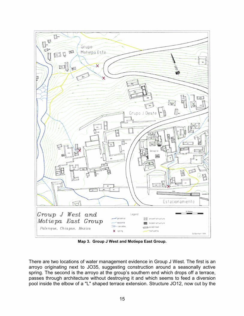
Group J West (Map 3)
Group J West was clearly part of Group J but has now been physically separated from it by the road to the ruins parking lot. The road cuts off two large structures, JO12 and JO26, and four east-west running terraces. The group sits upon land sloping gently down to the north. There are a total of forty-three structures, ten courtyards and seven terraces in Group J West. Exposed architecture exists within structures JO7, 12, 20, 22, 26, and 33. No looting evidence was found. The southernmost terrace (connected to structures JO1-4) is part of a series of interconnected terraces running almost 300m from the site center all the way to the Motiepa River. Only two structures, JO26 and JO28, are strongly suspected as being non-residential in function. Their form and size are more suggestive of the lineage ancestor worship shrines commonly found in association with residential courtyard groups.
15
Map 3. Group J West and Motiepa East Group.
There are two locations of water management evidence in Group J West. The first is an arroyo originating next to JO35, suggesting construction around a seasonally active spring. The second is the arroyo at the group’s southern end which drops off a terrace, passes through architecture without destroying it and which seems to feed a diversion pool inside the elbow of a "L" shaped terrace extension. Structure JO12, now cut by the

16
modern road, seems to have once been connected to structure J1, the Group IV residence of Chac Zutz’, the K’ak’ Ahaw of one of Palenque’s last kings, Akal Mo’ Nab.
The Motiepa East Group (Map 3)
The Motiepa East Group is situated on two natural plateaus stepping down to the north above the Motiepa’s eastern bank. Many of its structures have an unobstructed view of the Motiepa cascades. The group is quite small, only twelve structures arranged around two irregularly shaped patios. No constructed terracing was detected. The architecture is small and low-lying, assumably all residential. No exposed architecture was found and only one looter’s pit, in ME1. While no clear water management evidence was found, the three arroyos that join within the group seem to have been redirected. Artificial leveling done during the construction of the close by modern road may have affected the course of the easternmost of those arroyos, further confusing the surface evidence. To the south of the Motiepa East Group, situated on top of a large limestone outcrop, sits a ruined modern structure. A staircase carved into the outcrop’s face quite near the path provides access to the structure. Through discussions with long time Palenque resident Moises Morales it was learned that a German woman named Herta had once owned the structure. Herta lived in Palenque during the 1950’s and used the structure as a restaurant and bar. It is now little more than a cement platform and some crumbling red brick walls.
The Motiepa Group (Map 4)
The Motiepa Group is arranged on the hillside from Palenque’s main plateau down to the edge of the flood plains. Topography that appears to be an approximately twenty meter wide, dried watercourse runs down through the middle of the group. Calcified ledges stepping down the hillside, much like those in the Motiepa and Otulum cascades, are the evidence that water once flowed through the area in large quantity. There are forty-five structures and ten residential courtyards. Exposed architecture exists on the surfaces of structures M2, 11 and 13. In addition, a subterranean chamber of unknown character was detected in between structures M42 and M41. Looters have dug two separate pits into structure M2, one revealing an entrance into an intact inner chamber. While no water management features were securely identified, the aforementioned dried watercourse running through the Motiepa Group seems controlled in its placement. While surveying at the top of the dried watercourse, just below structure M10, the team noticed many bats flying around in the middle of the day. As bats are nocturnal, the presence of a cave or underground opening was suspected to be nearby. Though none was found, the possibility that it exists is still quite high. An extinct spring emerging from a cave would neatly explain the presence of the dried watercourse.

17
Map 4. Motiepa Group and Group G.
Moises’ Retreat (Map 5)
This group was named after Don Moises Morales, long-time advocate of the ruins and Palenque’s most knowledgeable tour guide. The editors of Robertson’s 1983 map gave the group its name. Though originally identified as the group’s central large complex (the platform unifying structures MR21, 24, 32 and 33) the PMP has expanded its

18
definition to include the surrounding smaller structures as well. Moises’ Retreat sits upon almost completely flat land and commands a beautiful view of the plains below. There are sixty structures in the group and nineteen small courtyards. Tall terraces bound the group to the north and south, architecturally separating it from the G and Xinil Pa’ Groups. Within the group there are three low-lying terraces in its eastern section. The central complex (comprised of structures MR21, 24, 32 and 33) sits upon a single large platform containing subterranean architecture. Much of the complex has exposed architecture, allowing interior investigation. Project members Jim Eckhardt and Heather Hurst crawled inside each subterranean chamber and passageway in order to record dimensions and descriptions. The long dark corridors encountered inside are reminiscent of those underneath Palenque’s central Palace. Elsewhere in the group, exposed architecture was found on the surfaces of structures MR4, 5, 8, 25, 26 and 28. MR4, in particular, is in a very good state of preservation. In addition, intact walls were found along the face of Moises’ Retreat’s northern terrace, held in place by calcification. A small tomb chamber has collapsed in, revealing its internal architecture two meters to the east of structure MR28. Evidence of looting was recorded in structures MR21, 24, 26, 32 and on the platform directly north of MR34.
Two separate areas of water management were detected within Moises’ Retreat. The smaller of the two is a seasonally flowing spring two meters to the east of structure MR22. The terrace there appears to have been intentionally in-set to provide an architectural opening from which the spring could flow downhill in a controlled fashion. The second, larger area of water management is located to the west of the group’s main complex and flows out of the nearby Piedras Bolas. There are two tributaries that appear to have been redirected to flow in between structures, one in between MR25 and 26 and the other in between MR26 and 27. Both join together just before dropping off into a small ravine which curves to rejoin the Piedras Bolas downstream. Sporadic areas of wet and dry along the courses of the tributaries indicate water is seeping under the patio they cross, likely re-emerging from a spring detected at the base of the ravine. This area is one of the best examples of Palenque’s architecture harmonizing with its natural setting.

19
Map 5. Moises’ Retreat.

20
Group G (Map 4)
Group G, also called "Blom’s Group G", was one of the locations identified during the 1920’s expedition of Franz Blom. As with most of Blom’s identified groups, his attention was given to the group due to its accessible tombs. While Blom’s drawing of Group G (1927) identified only two structures, the PMP map identifies twenty structures and five small courtyards. One large platform, structure G12, forms the step down in between Group G’s two flat areas. Structures G3, 6, 12 and 17 have exposed architecture. G17’s visible architecture is accessed through a hole in its half-meter tall platform and appears to be a pair of small tomb chambers. G3, recorded first by Blom, is a two meters tall structure with a collapse hole in its top. The structure’s interior is still in good condition with stucco on the walls and two intact doorways (one sealed up).
The wide plateau below and to the north of Group G is an area of unique character. Though it is a flat, upland plateau, ideal for residential construction, the land is completely empty of buildings. The 1983 Robertson map identifies it as a "1968 milpa". The area’s north end drops sharply off an approximately ten-meter tall limestone cliff. The face of that cliff is highly eroded and calcified, indicating prolonged exposure to flowing water. This water run-off evidence combined with the plateau’s oddly empty state, lead the survey team to suspect it may have been a small, inner-city milpa. Unfortunately, its use as a milpa in modern times may have precluded phosphate soil testing to confirm or deny its ancient identity.
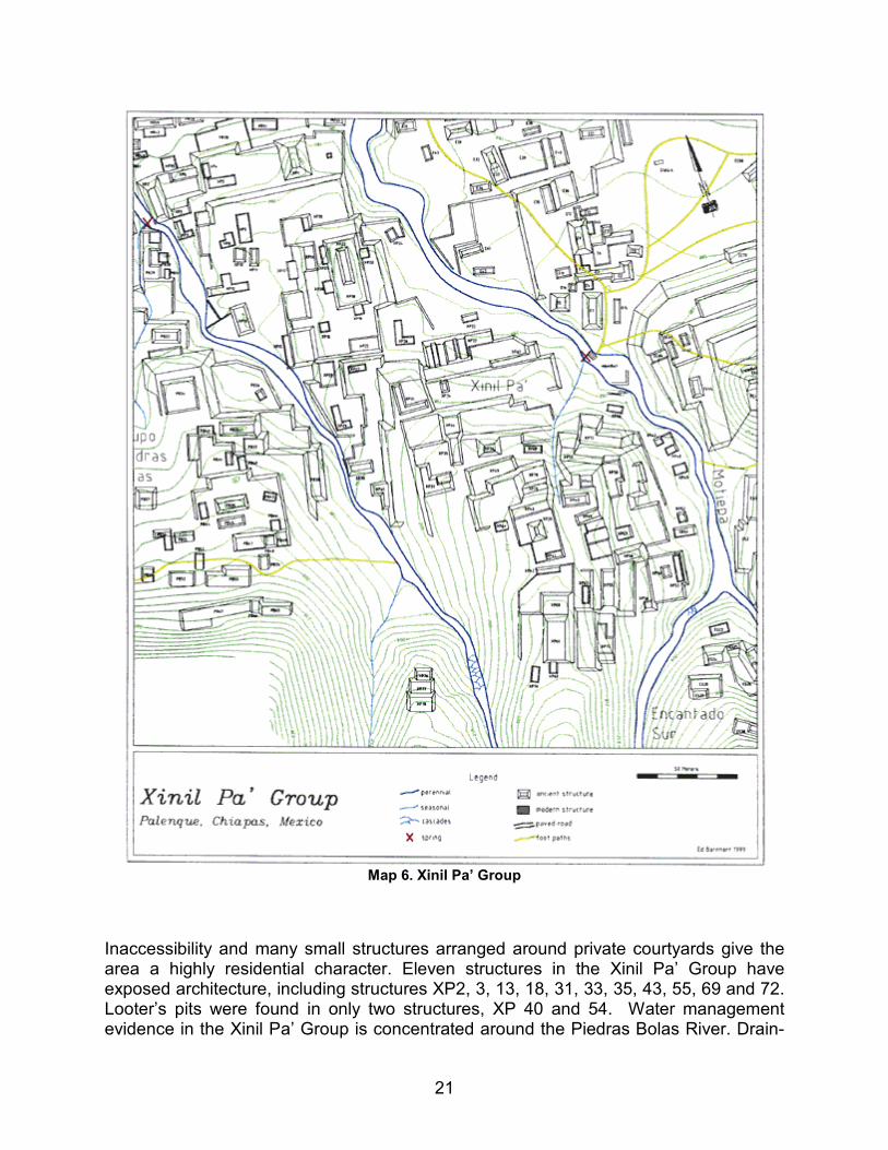
The Xinil Pa’ Group (Map 6)
The Xinil Pa’ group is a densely arranged group of structures climbing up hill in between the Piedras Bolas and Motiepa Rivers. A series of eight terraces step forty-two meters up the hillside creating flat surfaces for Xinil Pa’s seventy-eight structures and fifteen small courtyards. The two largest structures in Xinil Pa’, XP1 and 2, are located at its northernmost edge, bordering Moises’ Retreat. XP1 is the largest and has an associated altar-like feature on its eastern side patio. XP2 flanks the Piedras Bolas and has an almost completely intact western wall. The southern section of the Xinil Pa’ group, containing the highest density of structures, may be the area of Robertson’s map named the "Great House Group". Location discrepancies make map comparisons less than clear. Considering the interconnected nature of the construction as it climbs up the hillside, the entire area was included under the Xinil Pa’ Group name. Robertson’s map also records a large structure named "Bates Pyramid". Though map comparison was again unclear, structure XP36 appears to be the most likely candidate for Bates Pyramid.
21
Map 6. Xinil Pa’ Group
Inaccessibility and many small structures arranged around private courtyards give the area a highly residential character. Eleven structures in the Xinil Pa’ Group have exposed architecture, including structures XP2, 3, 13, 18, 31, 33, 35, 43, 55, 69 and 72. Looter’s pits were found in only two structures, XP 40 and 54. Water management evidence in the Xinil Pa’ Group is concentrated around the Piedras Bolas River. Drain-

22
like features are visible in the river’s bank west of structures XP13 and 30. Large amounts of cut stone lie strewn around in the Piedras Bolas River from structure XP12 down to Moises’ Retreat structure MR61. On the opposite side of the group, the dry arroyo between structures XP40 and 43 feeds down into the Motiepa River without cutting into the surrounding architecture, suggesting at minimum that its course was accounted for during construction, if not created by the construction. Lastly, a word on the Xinil Pa’ terraces. At their great size and the fact that they are the platforms for most of the group’s residential courtyards, they seem to be evidence of a large communal labor force.
The Piedras Bolas Group (Map 7)
Like the nearby Xinil Pa’ Group, the Piedras Bolas Group climbs up the hillside partially using four wide terraces as leveled building surfaces. The group runs primarily along the western bank of the Piedras Bolas River, hence its given name. There are sixty-seven structures and twelve small courtyards contained within the group. None of the structures appear obviously non-residential. Exposed architecture was documented on structures PB1, 7, 9, 15, 18, 31, 32, 39 and 48. Looter’s pits were found in only three structures, PB1, 15 and 35. The southernmost structures of the Piedras Bolas Group are built into a steep hillside as long, narrow platforms. Above those platforms the hill rises another twenty-five meters to a flat, natural plateau (not yet documented on the PMP map). Though the plateau was reconnaissance for a full day, no structures were found. The plateau did, however, contain three interesting pits, ten meters in average diameter and one to two meters in depth, with large limestone chunks scattered around their edges. Their form suggests quarry pits. Given that no structures were encountered on the plateau, the decision was made to hold off on formally surveying the area and to spend the team’s limited time in the areas of settlement below.
One of Palenque’s more interesting water management features was documented in the northwest part of the Piedras Bolas Group. Structure PB7 has a pool connected to its southern side. The pool is walled on all four sides and has a spring welling up from its southwest corner. The pool drains by a conduit traveling underneath structure PB7. The water flows out of the structure’s north side, travels under an arroyo level stone-covered channel (2m in length) and then winds eastward to join the Piedras Bolas. At that point of the Piedras Bolas’ course most of its water is being fed into it via this small arroyo. The pool at the arroyo’s origin still functions to collect water from the spring that it was built around.

23
Map 7. Piedras Bolas Group and the Olividado.

24
The Olvidado Group (Map 7)
The Olvidado Group is a small group of structures arranged around the well-known Olvidado Temple. The Olvidado Temple was first recorded by Blom in the 1920’s and excavated by Berlin in the 1940’s. Including the Olvidado Temple, there are ten structures and four wide platforms in the group. Thirty meters to the east of the Olvidado Temple lies a large platform identified by Blom as "Group I." The Group I platform was built into the hillside and has two small structures on top. The eastern of those two structures, O1, has a collapse hole on its top revealing a chamber some two meters down, inside the large platform. Blom’s report (1926) records a burial chamber was found there.
Generally speaking, the Olvidado Group does not appear to be residential. The Group I platform and the Olvidado Temple seem too visible to have functioned as private quarters. The smaller associated structures, especially the low terraces, seem to be supporting architecture rather than private spaces. None of the patios or courtyards typically associated with residential activities were found in the Olvidado Group. The next section, discussing the Picota Group, will discuss a connection between the Olvidado and Picota Groups.
The Picota Group (Map 8)
The Picota Group includes a diverse collection of structures, both public and residential. Its boundaries, with the exception of its western section, were drawn by the use of watercourses as borders. There are a total of sixty-seven structures and eight small courtyards within the Picota Group. Exposed architecture exists on the surfaces of structures P3, 5, 12, 26, 37 and 61. No looter’s pits were found in direct contact with the structures of the Picota Group but one pit was dug into the terrace directly in front of structure P37.
The structures and features encountered within the group differed from those recorded in previous maps to such an extent that, besides the Picota’s stela and aqueduct, the PMP map presents entirely new information.
The heart of the Picota Group is the irregularly shaped Picota Plaza. The irregular shape is caused by the protrusion of structures P23, 24 and 25 into the plaza, creating two distinct sections of plaza space. The western part of the plaza contains the La Picota Stela (the feature for which the area is named), the Picota aqueduct, and a well-preserved staircase climbing nine steps up from its southern boundary. Towering above the Picota Plaza to the south are a series of three terraces topped by structure P14 and its associated courtyard group. Structure P12, located five meters to the southeast of P14 has an area of collapse in its top revealing a subterranean tomb chamber below.

25
Map 8. La Picota Group.
In form and geographic placement, the line of temple-like structures running from the structure P14 eastward to the Group I platform are reminiscent of the line of structures in Palenque’s primary center created by Temples XII, XIII and the Inscriptions. Both areas have temples built into the hillside overlooking a plaza. Acknowledging that XII, XIII and the Inscriptions are funerary monuments, a similar function is suspected for

26
these southern temples of the Picota Group. Collectively, the presence of a large plaza, a stela, an elaborate aqueduct and a line of funerary temples along the south edge give the Picota area a distinctly "central precinct" character. The large nearby structure designated the Escondido Platform further supports that conclusion. Palenque appears to have had not one, but two "centers".
The Picota Group’s northern section is more residential in character, comprised of smaller buildings arranged around courtyards and open patio spaces. Though included spatially as part of the Picota Group, this area of residential settlement also seems associated with the Lemon Group’s settlement just to the east.
The water management of the Picota Group is arguably Palenque’s most sophisticated example. The aqueduct is built of tightly fitted stones and fed by multiple springs. Its state of preservation is superior to that of the aqueduct in Palenque’s central precinct. With the exception of a few capstones that have fallen in, the Picota aqueduct is completely intact and functional. As the water spills from the aqueduct’s exit, it forms the watercourse known as the Picota River. The course of this river turns sharply to the east, passing through the Lemon and Nauyaka residential zones, and ultimately joining the Piedras Bolas River via a wide area of shallow cascades. The fact that the Picota, unlike Palenque’s other rivers, does not follow gravity and flow straight north towards the floodplains below strongly suggests its course was altered to flow through the residential areas.
The Lemon Group (Map 9)
The Lemon Group sits on almost completely flat land along the southern side of the Picota River. The vegetation surrounding the group is extremely dense as a result of its former use as cattleland. The group’s name comes from the presence of many lemon (not lime) trees sporadically found within its boundaries. Since they are not indigenous to the area it is assumed they were planted by the former landowner. The groups named Hochol Bi’ and Atotob in the Robertson map could not be clearly identified but were probably found within what is now defined the Lemon Group. There are eighty structures and fifteen residential courtyards within the group, most of which were built along the southern bank of the Picota River. The majority of the group’s structures are small and tightly clustered. Architecture exposed at the surface was documented on structures L4 and 7. The single looter’s pit of the Lemon Group is located one meter north of structure L10. The group’s largest structure, L67, was found less than ten meters from the main footpath through the area. Though the structure is over four meters in height and thirty meters long, the dense vegetation covering it had completely hidden it from view. Unlike other groups found in Palenque’s western region, the Lemon Group appears to have a large open plaza in its center, linking all the individual courtyard groups to one communal space. There seems to have been a communal agreement to leave the area free of buildings.

27
Map 9. The Nauyaka Group and Lemon Group.
28
The Nauyaka Group (Map 9)
Except for its very northern end, the Nauyaka Group sits on flat land. It is bounded on the south by the Picota River and on the north by a steep hillside, as yet unrecorded by the PMP. Like the Lemon Group, many of its structures line the Picota River. The inspiration for the group’s name came from the large number of poisonous snakes encountered within its boundaries, five in the course of two weeks. Nauyaka is the local name for the snake more commonly called the Fer-de-Lance. A total of seventy-four structures and seventeen courtyards were found within the Nauyaka Group. In a pattern not seen in other sections of Palenque, most of the residential groups in this area are connected by elevated platforms. The looting evidence in the Nauyaka Group is by far the worst the PMP has encountered in Palenque. A total of eighteen looter’s pits were found, primarily in the groups on elevated platforms. Looted structures include structures N26, 29, 43, 45, 46, 47, 65 and 70. The very thick vegetation of the area combined with the noise of nearby rushing water made it a perfect area for clandestine looting. Evidence around the pits in structure N25 indicates the looting is relatively recent. Coke cans, chip bags and cigarette packs were found lying about still in good condition, as yet unaffected by the fast acting elements of a rain forest environment.
Structure N70 has an uniquely triangular form. A terrace on the other side of the Picota also has a side of odd orientation, mirroring N70’s riverside wall. The two structures together seem to bracket the Picota’s end as it falls into the Piedras Bolas River. Sitting in the Picota River next to structure N11 lies an interesting water management feature of indeterminate function. Though partially destroyed, it appears to be similar to the feature in the Motiepa River next to the Encantado Temple. It is a stone slab constructed box that has openings on either side through which water can pass. The similar Motiepa example was loosely termed an aqueduct in the Robertson map.
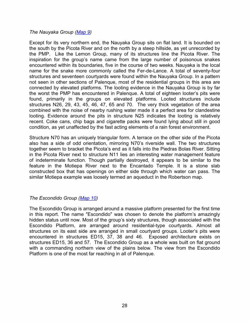
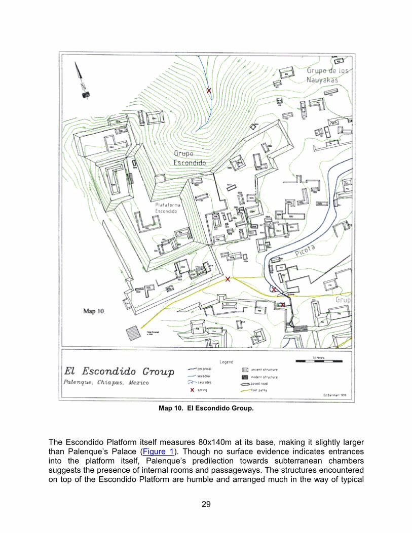
The Escondido Group (Map 10)
The Escondido Group is arranged around a massive platform presented for the first time in this report. The name "Escondido" was chosen to denote the platform’s amazingly hidden status until now. Most of the group’s sixty structures, though associated with the Escondido Platform, are arranged around residential-type courtyards. Almost all structures on its east side are arranged in small courtyard groups. Looter’s pits were encountered in structures ED15, 37, 38 and 46. Exposed architecture exists on structures ED15, 36 and 57. The Escondido Group as a whole was built on flat ground with a commanding northern view of the plains below. The view from the Escondido Platform is one of the most far reaching in all of Palenque.
29
Map 10. El Escondido Group.
The Escondido Platform itself measures 80x140m at its base, making it slightly larger than Palenque’s Palace (Figure 1). Though no surface evidence indicates entrances into the platform itself, Palenque’s predilection towards subterranean chambers suggests the presence of internal rooms and passageways. The structures encountered on top of the Escondido Platform are humble and arranged much in the way of typical
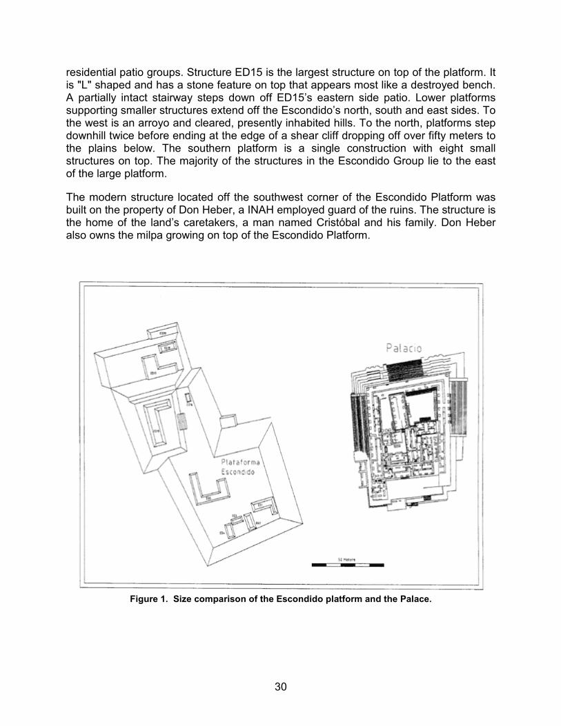
30
residential patio groups. Structure ED15 is the largest structure on top of the platform. It is "L" shaped and has a stone feature on top that appears most like a destroyed bench. A partially intact stairway steps down off ED15’s eastern side patio. Lower platforms supporting smaller structures extend off the Escondido’s north, south and east sides. To the west is an arroyo and cleared, presently inhabited hills. To the north, platforms step downhill twice before ending at the edge of a shear cliff dropping off over fifty meters to the plains below. The southern platform is a single construction with eight small structures on top. The majority of the structures in the Escondido Group lie to the east of the large platform.
The modern structure located off the southwest corner of the Escondido Platform was built on the property of Don Heber, a INAH employed guard of the ruins. The structure is the home of the land’s caretakers, a man named Cristóbal and his family. Don Heber also owns the milpa growing on top of the Escondido Platform.
Figure 1. Size comparison of the Escondido platform and the Palace.
31
Summation
There were two major changes made to our understanding of Palenque as a result of the PMP 1999 field season. One, we now know Palenque’s western section is dominated by a densely clustered residential zone, and two, a second "center" exists within the city’s boundaries. Bounded on both the east and west by areas of large, public architecture, Palenque’s western residential settlement is "urban" by definition. The "center" on Palenque’s western edge is suspected of being older than the city’s much larger primary center for the following reasons. First, the ceramic sequence defined by Dr. Robert Rands has identified specimens from the Picota area as some of the oldest at the site (p.c.). Second, data points collected in the Picota Plaza were found to be less than 50cm (on average) in elevation difference from those recorded in the plaza surrounding Palenque’s Palace. The central complex of Moises’ Retreat, though located along the same central plateau as the two big plazas, sits at an elevation seventeen meters lower. If the identical elevation of the two, almost one kilometer apart plazas is not a coincidence then one must have patterned itself upon the other. Two facts combine to point to the central plaza as the emulator. One, the Picota Plaza slopes very gently down to the river that defines its northern boundary. Since the river is shallow and at essentially plaza level we can assume the Picota Plaza was neither built up nor dug down to any large extent. In contrast, Palenque’s central plaza sits upon a terrace, built up as much as four meters in places. Clearly, if one plaza emulated the other, the smaller Picota Plaza was the original.
The discovery of this second center at Palenque leads to a hypothesis with potential to answer a growing question regarding the members of Palenque’s early royal lineage. Despite decades of excavation in Palenque’s central precinct archaeologists have found little evidence of royal family activities earlier than the time of Pakal. The exceptions, the XVIIIa tomb (Berlin, 1943) and the Reyna Roja (Gonzalez Cruz, 1998), are still under debate as to the antiquity of their time periods. David Stuart has read Palenque hieroglyphic texts referring to a place named "Tok Tan" as the origin place of the Palenque lineage, a place he believes to be separate from the primary center (p.c.). Could the Picota Plaza be the center of the dynasty’s original family members? Its size, suspected age, and obvious association with the site’s residential community make it a possibility worthy of further archaeological investigation.
Sources Cited
Blom Franz
1923 "Informe Sobre Las Ruinas de Palenque"
Blom, F. and O. La Farge
1926-1927
Tribes and Temples. MARI Publications 1 and 2.

32
Berlin-Neubart, Heinrich
1943 "Edificio XVIII", in Palenque 1926-1945, Roberto Garcia Moll, Ed., INAH.
Gonzalez Cruz, Arnoldo
1998 "El Templo De La Reina Roja, Palenque, Chiapas", Arqueologia Mexicana, Vol. V, Num. 30.
Robertson, M.G.
1983 Temple of the Inscriptions, Volume 1 of The Sculpture of Palenque. Princeton: Princeton University Press.

33
Architectural Analysis In Western Palenque
by James Eckhardt and Heather Hurst
During the 1999 season of the Palenque Mapping Project the team mapped the western portion of the site of Palenque. This paper gives information about the architecture of specific buildings in some of the groups that were mapped. These architectural insights are based totally on surface assessment, measurement of the interior and the exterior of the exposed buildings and crawling into collapsed interiors to extract more information. The architectural forms of the Moises’ Retreat Group, the Picota aqueduct system and surrounding structures in the Picota Group are discussed here.
The first area that this paper will look at is the Moises’ Retreat Group that is located between the Motiepa and Piedras Bolas rivers. The majority of the group sits upon the escarpment ridge proper, with the rest sloping down on terraces or natural hillside. Structure MR4 is where we would like to start; it is an "L"-shaped structure (24.45 x 16.61 m) on a raised platform (4.89 m high). The condition of the mound is much like the rest of the site; overgrown with trees and thick vines. The structure faces to the north and fortunately that area has the most visible architecture (Figures 1 and 2). The eastern portion of the north face is mostly collapsed but the rear interior is visible up to the spring-line. The estimated width of the interior is 2.20m, which is an average interior width in most of the rest of the group. The southwest corner of this chamber gives an estimated height. Even though the floor is buried, one is able to conclude that the maximum height to the spring-line would have been 1.30m. The spring-line is offset 13cm and the vault height itself is 1.0m. The western-most chamber is a later addition to this chamber. It is small and connected to the initial chamber by a window. Width of the chamber is 0.87m, length is 1.64m and the height to the spring-line is 1.86m. The vault of this chamber is interesting because it uses the exterior medial molding as the eastern half of the vault. Its height is 46cm. From these measurements and Hurst’s reconstruction drawings one can see that this building had many additions during the periods that it was in use and reuse (Abrams, ’98). Based on the structures position in the group and its architecture, it was more than likely middle to upper class residence (Johnston and Gonlin, ’98). The core of what we believe makes up Moises’ Retreat are the collection of buildings near the Piedras Bolas river, buildings MR19-21, 24 & 25, 29, 32 & 33, and 68. Once again the structures here are covered with thick vines and large trees. Many structures in the group have collapse and old looters trenches. These breaks in the structures were able to yield much architectural information and allowed a complex reconstruction drawing of the group (Figure 8). The preservation of these structures over the course of hundreds of years is a testament to the achievements of the ancient people of Palenque. On the eastern face of MR32 there is a collapse of a large chamber, which is easily entered from above. Inside we were able to take measurements of the connecting corridors, the doorways exiting to the west and the stairs that coincided with those doorways. The chamber itself is north-south oriented with two doorways opening to the west; one of the doorways is completely destroyed due to the collapse that allows entry. The other doorway has stairs leading down to the east and out of the structure. It is assumed the other was constructed similarly. The chamber itself is again 2.20m wide, over 7m in length and from reconstruction

34
estimates; the height to the spring-line is 2.70m. The vault adds another meter (Figure 3). This chamber is quite large and is connected to another chamber, by a small northwest corridor, that mirrors its dimensions (Figure 4). This chamber is almost identical in dimensions and north of the previous one, directly underneath the eastern side of the temple structure MR24. This chamber’s north wall has been sealed up and has created either an antechamber on the other side or was filled up and then sealed to create better support for the temple addition above it. There is evidence that there was another chamber, running north-south, on top of the chamber. This would explain the thick, wide capstones in the initial lower chamber as supports. We believe this shows the extensive masonry specialization that is characteristic of most architecture in Palenque (Fash, ’98). Moving to the south face of MR33, there is a thin corridor that is collapsed on both ends. We were able to traverse it with some difficulty. The interior height is a little over 2.0m with only a 30cm vault. Near the center of the corridor on the south side, are two " Ik’ " windows looking out to the plazuela to the south (Figure 5). Initially, it was thought that this corridor ran the entire length of the southern face of MR33. Upon more thought it is believed that the corridor’s east doorway would have had stairs and connected to the upper chamber in MR32, which is now destroyed. The western doorway either turned north into the bulk of the platform or possibly turned south, exiting into the plazuela. The western face of MR32 and MR33 has completely collapsed except a small part of it towards the northwest corner. It is believed that this corridor ran the length of both 32 and 33 with three doorways opening out to the west. On its preserved northwest corner, we see a window looking out to the north but it has evidence that it was changed into a window from an earlier doorway opening to the north. There were also some curtain holders in the small east-west running corridor directly north of the western corridor. Most of the north face of Moises’ Retreat has been destroyed by tree fall and seasonal water drainage. The platform MR68 is probably the remnants of a large stairway and the support platform of MR21 (Webster, ’98). Just north of it is a steep cliff that drops down to terrace structures, initially we believed that this was just natural rock but with further investigation we noticed cut blocks into the face of the cliff with limestone calcification over it. We found this to be a very interesting discovery because it is possible that what we have seen in Palenque before to be just calcification could very well be water drainage depositing a layer of calcite over architecture, not just in Moises’ Retreat but also in many other areas of the site. When we looked for this possibility in other areas of the site we were rewarded with evidence that it is indeed architecture rather than natural stone.
The other area of interest is the La Picota area and especially the aqueduct area. The La Picota aqueduct is part of the river system closer to the southern ridge of the mapped site. The Picota River flows down from the south and is then constricted by the construction of a large C-shaped group of mounds that opens to the north. The river is forced under these mounds, then the plaza, and then it’s used to feed the three constructed pools before emerging at the northern exit of the aqueduct (Figures 6 and 7). The aqueduct begins under the plaza passing under the northwest corner of a large stairway with faced blocks that are very large; average is around 2 by 0.50 by 0.80 meters. At this point, the ceiling of the aqueduct is only 20cm beneath the plaza. Near the stela it makes a turn of nearly 90° to the west, then gradually curves north before the water exits and continues down the Picota River. There are enormous faced blocks

35
in the interior walls that have no calcification, as an interesting note the water in the aqueduct must move fast enough at the base of it never to accumulate calcite. Also, the slabs used as capstones must have been exacting enough not to let water from the surface to seep through, very good evidence for elaborate specialization (Hansen, ’98). The slabs cap the entire course of the aqueduct and it is likely that these slabs could have been removed for maintenance. The walls are vertical and have no offset before the capstones, meaning that there is no vault in the aqueduct. As the aqueduct travels north, the heights of the walls increase. This maintains the level of the plaza while providing slope to move water. The walls taper slightly as height increases. There is no stucco present inside the aqueduct. The entrance, where the water is funneled into the aqueduct, is a rectangular doorway with a huge capstone. It is possible that this entrance was blocked with another large stone to control the reservoir level. The exit is a tall tapering vault, much like the shape of the Picota Stela itself (2.65m high, .53m at base, .11m at top) and is narrower than the channel just inside the door, which would force the water out dramatically. The aqueduct fills three pools. The first pool is L-shaped and is in the south corner of the western flanking terrace. The water is channeled into its northeast corner, and channeled out of the southeast corner. The second pool is on the north side of the terrace and the drain that feeds this pool (24 x 50 cm.) is 1.21m below the plaza level. A stepped wall is visible on the eastern side of the second pool. The third pool is channeled from the Picota River just after exiting the aqueduct with the walls overgrown and fallen. The only true wall lies on the western side and only one course is visible above the water line.
This paper has explained some of the architecture of Palenque that could not be rendered in the greater map. These renderings of Moises’ Retreat and the Picota aqueduct were produced by what was seen from the exterior and interior without excavation. We hope that these findings will encourage others to move into the western portion of Palenque and to do more analysis.

36
Figures 1 & 2.
Figure 3.

37
Figure 4 & 5.

38
Figure 6 & 7.
Figure 8.

39
Sources Cited
Abrams, Elliot M.
1998 Structures as Sites: The Construction Process and Maya Architecture. Dumbarton Oaks Research Library and Collection, Washington, D.C.
Fash, William L.
1998 Dynastic Architectural Programs: Intention and Design in Classic Maya Buildings at Copán and Other Sites. Dumbarton Oaks Research Library and Collection, Washington, D.C.
Hansen, Richard D.
1998 Continuity and Disjunction: The Pre-Classic Antecedents of Classic Maya Architecture. Dumbarton Oaks Research Library and Collection, Washington, D.C.
Johnston, Kevin J. and Gonlin, Nancy
1998 What Do Houses Mean? Approaches to the Analysis of Classic Maya Commoner Residences. Dumbarton Oaks Research Library and Collection, Washington, D.C.
Webster, David
1998 Classic Maya Architecture: Implications and Comparisons. Dumbarton Oaks Research Library and Collection, Washington, D.C.

40
Palenque’s Water Management
by Kirk D. French
Another aspect of the Palenque Mapping Project is the documentation of the numerous water features found within the site boundary. Palenque’s water management differed from that of other lowland Maya sites due to its many perennial water sources. The Palenque Mapping Project has located twenty-six springs within site boundaries. Of those, thirteen are associated with architecture. Most of the sites in the lowlands dealt with the conservation and storage of water. Palenque had an abundance of water, which gave them an opportunity to devise new and inventive ways of controlling and moving the flow of water. This helps to explain the extreme diversity of Palenque’s water management systems.
Figure 1 - The Otulum
The Otulum is the stream that runs through Palenque’s center. It begins high in the mountains about 325 meters due south of the Palace. The Otulum winds down the mountainside heading north. After the stream passes Temple XXII it enters its first water management feature. The stream becomes lined with walls of cut stones where the artificial channeling begins. The channel is about 2 meters in depth and 1.5 meters in width (See Figure 1). The wall-lined channel continues for another 125 meters until it enters a beautifully preserved corbel arched underground aqueduct for 55 meters (See Figure 2). By building atop of the stream, the Maya created a land bridge. This aqueduct is Palenque’s largest and is approximately 3 meters in height and includes a series of cut stone supporting beams in its ceiling. As the stream exits the aqueduct some

41
collapse is evident. The Otulum then continues northward where it transforms into a series of magnificent waterfalls.
Figure 2 - Interior of the Otulum aqueduct
The Motiepa is the next major stream to the west of the Otulum. The Motiepa’s source is unknown because it begins outside of the site boundary. Much like the Otulum, the Motiepa begins at a high elevation in the mountains. This water source defines the western boundaries of the Encantado Group and Group E, and the eastern boundaries of the Xinal Pa’ and Moises Retreat. The most interesting water features on the Motiepa are a partial damn (See Figure 3) and a heavily calcified aqueduct (See Figure 4).
Figure 3 - Motiepa’s partial dam

42
Figure 4 - Motiepa’s calcified aqueduct
This aqueduct is difficult to completely identify due to the extreme amount of calcification. While standing atop of the feature one can clearly hear the sound of water rushing inside. Without the excavation of this calcified aqueduct little can be known about it.
The Piedras Bolas is similar to the Otulum and the Motiepa, in the sense that it starts at a high elevation in the mountains to the south of the site. Due to the close proximity of the two streams in the south, it is speculated that they share the same source that would be located outside the site boundary. The Piedras Bolas defines the western boundaries of the Xinil Pa’ and Moises Retreat. It also defines the eastern boundaries of the Piedras Bolas Group and the Lemon Group.
Figure 5 - Interior of Piedras Bolas aqueduct
The first water feature that this stream enters is a fascinating aqueduct located near structure 30 of the Xinil Pa’ Group. This particular aqueduct is partially collapsed at its southern end. At this location of the aqueduct the dimensions are approximately 50 cm in width and 70 cm in depth. As the aqueduct continues north 8 meters it becomes increasingly smaller in size (See Figure 5) when the water exits the aqueduct the

43
dimensions are approximately 25 cm x 25 cm (See Figure 6). Although water still flows through the aqueduct, it does so slowly due to the collapse.
Figure 6 - The exit of Piedras Bolas aqueduct
Because of this, the majority of the water now has been forced to flow to the west side of the aqueduct. Prior to the collapse, the majority, if not all, of the Piedras Bolas would have flowed through this system. By taking a large amount of flowing water and decreasing the size of its path creates pressure, thus the aqueduct would have created a large amount of water pressure.
The Piedras Bolas continues northward 85 meters and then enters another water feature. This feature is a complex drain and aqueduct combination. The drain begins at structure 13 of the Xinil Pa’ Group and flows east to west toward the Piedras Bolas. This drain is non-functional. The aqueduct’s beginning is unknown but is functional, flowing south to north (See Figure 7). It is possible that the aqueduct actually flows beneath the drain creating a crisscross effect. The water exits the aqueduct by flowing into the Piedras Bolas.
Figure 7 - Interior of Piedras Bolas aqueduct
44
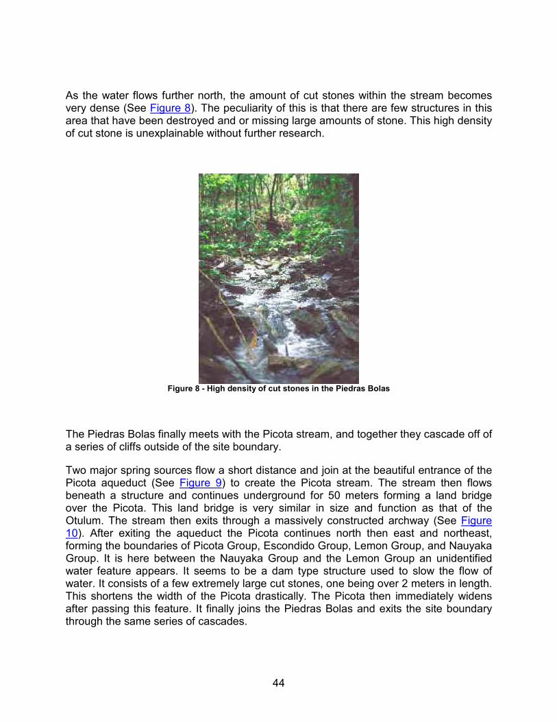
As the water flows further north, the amount of cut stones within the stream becomes very dense (See Figure 8). The peculiarity of this is that there are few structures in this area that have been destroyed and or missing large amounts of stone. This high density of cut stone is unexplainable without further research.
Figure 8 - High density of cut stones in the Piedras Bolas
The Piedras Bolas finally meets with the Picota stream, and together they cascade off of a series of cliffs outside of the site boundary.
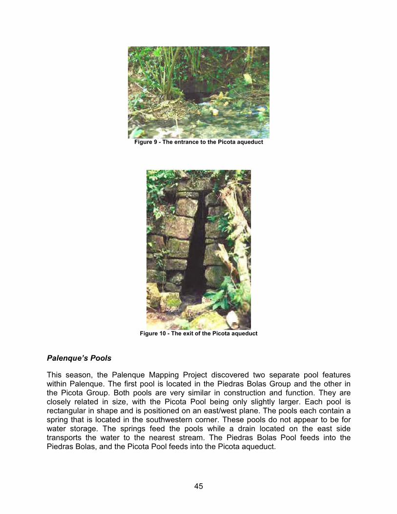
Two major spring sources flow a short distance and join at the beautiful entrance of the Picota aqueduct (See Figure 9) to create the Picota stream. The stream then flows beneath a structure and continues underground for 50 meters forming a land bridge over the Picota. This land bridge is very similar in size and function as that of the Otulum. The stream then exits through a massively constructed archway (See Figure 10). After exiting the aqueduct the Picota continues north then east and northeast, forming the boundaries of Picota Group, Escondido Group, Lemon Group, and Nauyaka Group. It is here between the Nauyaka Group and the Lemon Group an unidentified water feature appears. It seems to be a dam type structure used to slow the flow of water. It consists of a few extremely large cut stones, one being over 2 meters in length. This shortens the width of the Picota drastically. The Picota then immediately widens after passing this feature. It finally joins the Piedras Bolas and exits the site boundary through the same series of cascades.
45
Figure 9 - The entrance to the Picota aqueduct
Figure 10 - The exit of the Picota aqueduct
Palenque’s Pools
This season, the Palenque Mapping Project discovered two separate pool features within Palenque. The first pool is located in the Piedras Bolas Group and the other in the Picota Group. Both pools are very similar in construction and function. They are closely related in size, with the Picota Pool being only slightly larger. Each pool is rectangular in shape and is positioned on an east/west plane. The pools each contain a spring that is located in the southwestern corner. These pools do not appear to be for water storage. The springs feed the pools while a drain located on the east side transports the water to the nearest stream. The Piedras Bolas Pool feeds into the Piedras Bolas, and the Picota Pool feeds into the Picota aqueduct.