The Nature of 2040 - Oregon Metro
16
The Nature of 2040 The region’s 50-year plan for managing growth
Transcript of The Nature of 2040 - Oregon Metro

T h e N a t u r e o f
2040
The region’s 50-year plan for managing growth

1
The region’s 50 year strategy for managing growth
R ich in natural resources,this place where we
live has been compared toparadise. “Eden’s Gate,” asthe Willamette Valley wascalled, provides a lifestyle,economy and culture thatis deeply rooted in theenvironment. Just as wehonor preceding gener-ations for their foresightin protecting Forest Park,the Columbia Gorge andthe ocean shore, so willfuture generations judgeus by our efforts to protectthe nature of this region.
One of the most effectiveways to protect our environ-ment, both the built andthe natural worlds weinhabit, is by planning forthe future. That’s exactlythe focus of the 2040Growth Concept, Metro’slong-range growthmanagement strategy.(“2040” comes from theidea of planning 50 yearsahead – from the year1990.) Planning our futurebased on what’s importantto us makes sense. Theresidents of this regionhave consistently saidthat the natural beautyhere and comfortablefeel of our communitiesare important to them.
The 2040 Growth Conceptreflects the things thepeople who live herevalue most:
Future
generations
will judge us
by our efforts
to protect the
nature of this
region.
Planning that protects the nature of the region
Our air quality can be measured by whether we cansee Mt. Hood. Our ability to continue to enjoy theview of the mountain, visible from just aboutanywhere in the region, may well indicate whetherwe’ve succeeded or failed in our efforts to balanceour concerns for the environment with our need tolive and flourish in this region.
• access to nature
• protecting habitats forwildlife and people
• safe and stable neigh-borhoods
• transportation choices
• resources for futuregenerations
• a vibrant culturaleconomy.
By engaging the commu-nity in a discussion aboutthe issues that confront usall, we create the opportu-nity to make consciouschoices about wheregrowth will go, hownatural areas will beprotected and how ourcommunities will work.

2
An Oregon history of planning for the future
O regon has a longhistory of planning
ahead to manage theeffects of growth.Oregon’s land-use lawsplay a major role indetermining how ourcities grow, protectingfarm and forestland fromdevelopment and helpingmaintain our economicvitality.
When did thisplanning begin?
In 1973, Gov. Tom McCalland his allies convincedthe Oregon Legislature toadopt the nation’s first setof land-use planning laws.McCall, with the help of aunique coalition offarmers and environmen-talists, persuaded theLegislature that the state’snatural beauty and easyaccess to nature would belost in a rising tide ofurban sprawl. The newgoals and guidelinesrequired every city andcounty in Oregon to have
a long-range plan address-ing future growth thatmeets both local andstatewide goals.
In summary, state land-usegoals require:
• setting urban growthboundaries
• using urban land wisely
• protecting naturalresources.
Voter’s approvecreation of Metro
In 1978, voters within themetropolitan area ofClackamas, Multnomahand Washington countiesapproved a ballot measurethat made Metro thenation’s first electedregional government.That vote gave Metro theresponsibility for coordi-nating the land-use plansof the region’s 27 jurisdic-tions as well as otherissues of “regionalsignificance.” State land-use laws required Metroto establish a regionalurban growth boundary(UGB) and empowered theMetro Council to makebinding policy decisionsregarding developmentwithin the boundary.Metro’s responsibilitiesand procedures can befound in Oregon RevisedStatutes Chapter 268.
The challenge for our region
Metro’s population projections showed that theland-use strategies in place in 1990 would not beenough to continue to protect farmland, forestsand the natural areas on the edges of the regionfrom development. Our public services such asutilities, public safety and transportation systemswould also be stretched beyond capacity. From1992 to 1997, 131,000 more people joined thethree-county population. From 1997 to 2017,another 497,000 people are expected to live inthe region. Almost half will be our children andgrandchildren.
For more informationabout Oregon land-usegoals, call the OregonDepartment of LandConservation andDevelopment at (503)373-0050 or visit itsweb site atwww.lcd.state.or.us
The urban growth bound-ary marks the separationbetween rural and urbanland. UGBs are required bystate law to contain anadequate supply ofbuildable land to accom-modate the expectedgrowth during a 20-yearperiod. By providing landfor urban uses within theboundary, rural lands canbe protected from un-wanted urban sprawl.
Metro’s urban growth boundary
Adopted by the MetroCouncil in 1979, theregion’s UGB includes 24cities and urban portions ofthree counties and contains237,000 acres. It is Metro’sjob to work with localgovernments to estimategrowth for the next 20years and to make adjust-ments to the UGB based onthose calculations.
3
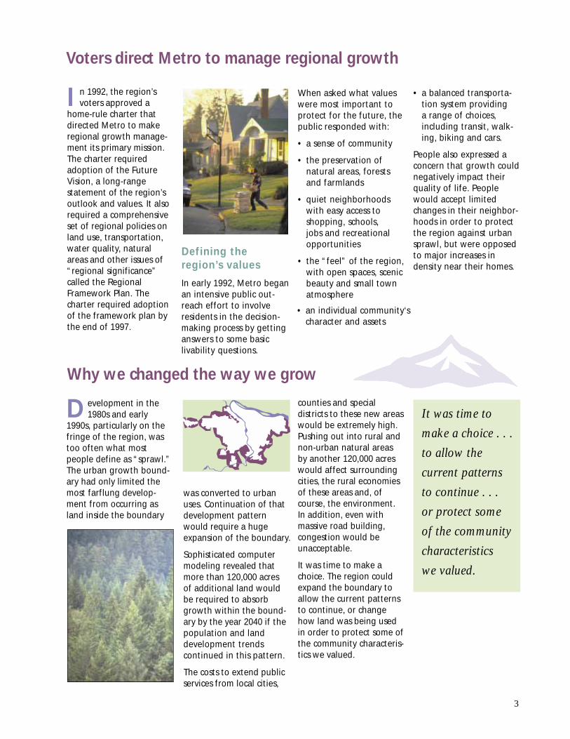
I n 1992, the region’svoters approved a
home-rule charter thatdirected Metro to makeregional growth manage-ment its primary mission.The charter requiredadoption of the FutureVision, a long-rangestatement of the region’soutlook and values. It alsorequired a comprehensiveset of regional policies onland use, transportation,water quality, naturalareas and other issues of“regional significance”called the RegionalFramework Plan. Thecharter required adoptionof the framework plan bythe end of 1997.
Voters direct Metro to manage regional growth
D evelopment in the1980s and early
1990s, particularly on thefringe of the region, wastoo often what mostpeople define as “sprawl.”The urban growth bound-ary had only limited themost farflung develop-ment from occurring asland inside the boundary
Why we changed the way we grow
It was time to
make a choice . . .
to allow the
current patterns
to continue . . .
or protect some
of the community
characteristics
we valued.
Defining theregion’s values
In early 1992, Metro beganan intensive public out-reach effort to involveresidents in the decision-making process by gettinganswers to some basiclivability questions.
When asked what valueswere most important toprotect for the future, thepublic responded with:
• a sense of community
• the preservation ofnatural areas, forestsand farmlands
• quiet neighborhoodswith easy access toshopping, schools,jobs and recreationalopportunities
• the “feel” of the region,with open spaces, scenicbeauty and small townatmosphere
was converted to urbanuses. Continuation of thatdevelopment patternwould require a hugeexpansion of the boundary.
Sophisticated computermodeling revealed thatmore than 120,000 acresof additional land wouldbe required to absorbgrowth within the bound-ary by the year 2040 if thepopulation and landdevelopment trendscontinued in this pattern.
The costs to extend publicservices from local cities,
counties and specialdistricts to these new areaswould be extremely high.Pushing out into rural andnon-urban natural areasby another 120,000 acreswould affect surroundingcities, the rural economiesof these areas and, ofcourse, the environment.In addition, even withmassive road building,congestion would beunacceptable.
It was time to make achoice. The region couldexpand the boundary toallow the current patternsto continue, or changehow land was being usedin order to protect some ofthe community characteris-tics we valued.
• a balanced transporta-tion system providinga range of choices,including transit, walk-ing, biking and cars.
People also expressed aconcern that growth couldnegatively impact theirquality of life. Peoplewould accept limitedchanges in their neighbor-hoods in order to protectthe region against urbansprawl, but were opposedto major increases indensity near their homes.
• an individual community‘scharacter and assets

4
Concept CNeighboring cities
Concept AGrowing out
No UGB expansion; growthaccommodated throughdevelopment of existing landwithin the urban growthboundary.
234,000 acres in UGB
Moderate expansion of theUGB; growth focused incenters, corridors andneighboring cities.
257,000 acres in UGB(22,000 acres added tothe UGB)
F rom 1992 to 1994, Metro used urban developmentanalysis tools and forecasting technologies to
study different growth management strategies.A wide range of possible approaches were identifiedand analyzed for impacts to the region’s neighbor-hoods, transportation system, natural resources andkey urban services. This intensive study, originallycalled Region 2040, allowed Metro to focus on anumber of options to prepare for local jurisdictionsand the public to review. Metro ultimately tested fourscenarios for how the region could grow.
Each option was analyzed for effects on:
• land consumption
• travel times and distances
• open spaces and air quality
• various urban landscapes.
The four options, called “growth concepts,” presenteddifferent philosophies about how the region shouldactively manage growth.
Discovering the choices
Base case – Continuing pattern
Vancouver
Portland
NORTH
Vancouver
Portland
NORTH
Vancouver
Portland
NORTH
Concept BGrowing up
Significant expansion of theUGB; new growth at urbanedge develops mostly in theform of housing.
284,000 acres in UGB(51,000 acres addedto UGB)
“Growth concepts”
presented different
philosophies about
how the region
should actively
manage growth.
Greatest expansion of UGB; continuation ofdevelopment patterns occurring between 1985and 1990.
354,000 acres in UGB(121,000 acres added to UGB)
November 1992 – Votersapprove home-rule charterfor Metro, making growthmanagement the agency’stop priority.
1992-94 – Region 2040 publicinvolvement and technicalanalysis process, includingdevelopment of the alterna-tive concepts for growth.
Spring-summer 1994 –Major public involvementeffort on the growth conceptoccurs, including televisionand print advertising, youthactivities, open houses and aquestionnaire to everyhousehold in the region.
2 0 4 0 T i m e l i n e
1991 – Council adoptsRegional Urban Growth Goalsand Objectives (RUGGOs) asthe guide for Metro’s long-range planning efforts.

5
Community discussion shapes strategies
Providing a wide range of publicinvolvement opportunities
Since the beginning of Region 2040 in 1992,Metro’s public involvement process helpedpeople become aware of the impacts ofgrowth and provided opportunities toshape, review and contribute to thedecision-making process.
Communications tools included:
• television, radio and print newspaper ads
• a regionwide questionnaire on livabilityissues sent to more than 500,000 households
• dozens of public open houses, workshopsand forums
• a video distributed free at BlockbusterVideo to 4,000 customers
• an information and comment phone line
• youth involvement projects
• survey on growth management strategiesmailed to 70,000 households and distributedat coffee shops, restaurants, bookstores andpublic libraries as well as in newspapers andon Metro’s web site
• presentations to hundreds of civicand community organizations
• newsletters to a mailing listthat grew to 65,000 interestedresidents.
Metro used innovativeways to draw attentionto regional growth issues.To help people imaginethe future, 3-D glasses andmaps were placed at coffeeshops around the region.
December 1995 – MetroCouncil adopts 2040 GrowthConcept with unanimoussupport from the MetroPolicy Advisory Committee,made up of local electedofficials, special districtrepresentatives and citizens.
Summer 1997 – Metrodistributes a survey to engagepublic in finalizing theRegional Framework Plan.
November 1996 – Metroapproves the Urban GrowthManagement FunctionalPlan, a toolbox of planningpolicies for local governmentsto use to implement the 2040Growth Concept.
May 1995 – Voters approve$135 million bond measure toacquire open spaces.
Dozens of public
open houses,
workshops and
forums were held
throughout the
region.
I n spring 1994, Metro conducted an extensive publicinvolvement effort to find out what people thought
about the concepts. A questionnaire was sent to everyhome (more than 500,000 households) in the region.More than 17,000 people returned them with 12,000writing additional comments.
This is what Metro heard from those who responded tothe questionnaire:
• Increasing development along transit corridorsreceived the strongest support (83 percent) amongthe four strategies.
• More than three-fourths of those responding(77 percent) supported encouraging growth in estab-lished centers, which serve as ”hubs“ for providinggoods and services to their respective communities.
• A majority (58 percent) of all respondents sup-ported reducing average new residential lot sizes.
• Reducing parking inretail and commercialdevelopment receivedsupport from 55 percentof those responding.

6
Comparing the concepts
Growth is encouraged in centers and corridorswith increased emphasis on redevelopmentwithin the urban growth boundary.
248,000 to 252,000 acres in UGB(15,000 to 19,000 acres added to the UGBover 50 years)
2040 recommended alternative
Vancouver
Portland
NORTH
Finding the balance – the 2040 Growth Concept emerges
Air qualityNitrous oxide levels(kilograms per day)
Base case
Concept A
Concept B
Concept C
2040 Growth Concept
78 80,0
0082
,000
84,0
0086
,000
88,0
0090
,000
KILO
GRAM
S
92,0
0094
,000
96,0
00
Land consumption
Base case
Concept A
Concept B
Concept C
2040 Growth Concept
0 20,0
0040
,000
60,0
0080
,000
100,
000
120,
000
1400
,000
ACRES
Vehicle miles traveledWithin the UGB
Base case
Concept A
Concept B
Concept C
2040 Growth Concept
0 2 4 6 8 10 12 140
MIL
ES
TransitRidership
Base case
Concept A
Concept B
Concept C
2040 Growth Concept
0 100,
000
200,
000
300,
000
400,
000
500,
000
600,
000
DAILY R
IDER
S TransitDaily service hours
Base case
Concept A
Concept B
Concept C
2040 Growth Concept
0 2,00
04,
000
6,00
08,
000
10,0
0012
,000
HOURS
14,0
00
A wide range
of possible
approaches were
identified and
analyzed.
CongestionRoadway miles during rush hours
Base case
Concept A
Concept B
Concept C
2040 Growth Concept
0 100
200
300
400
500
600
MIL
ES
700
800
I n September 1994, a new idea emerged. Drawingfrom the best features of the different approaches –
the 2040 Growth Concept won the unanimous supportof local government partners on the Metro PolicyAdvisory Committee. The Metro Council adopted the2040 Growth Concept in 1995.
Land-use decisions are guided to:
• encourage more efficient use of the land in cities,business centers on “main streets” and on majortransit routes
• protect natural areas, parks, streams and farmlandboth inside and outside the urban growth boundary
• promote a transportation system that includes alltypes of travel, such as bicycling, walking and usingmass transit, as well as cars and freight
• work with neighboring cities just outside the region –such as Sandy, Canby and Newberg – to keep theseparation between communities
• promote diverse housing options for all residents ofthe region.

7
What happens to existing neighborhoods in 2040?
I f you live in an estab-lished neighborhood,
whether in the heart ofPortland or in Gresham orBeaverton, your neighbor-hood should continue tolook and function like itdoes now.
Protecting existing neigh-borhoods is one of themost important aspects ofthe 2040 Growth Concept.The character of yourneighborhood shouldremain fundamentally thesame even though rowhouses may appear nearyou, new developmentsmay go in near busy roadsor houses may be built ononce-empty lots. Changeswill occur gradually overthe course of many years.
Another major goal ofMetro’s growth manage-ment effort is to provide arange of housing options,including affordableapartments over retailstores, row houses andapartments as well assingle-family homes, for allresidents of our region –now and in the future.
Protecting existing
neighborhoods is
one of the most
important aspects
of the 2040
Growth Concept.
What may suit a familywith children may not suita single adult or a retiredcouple whose childrenare grown.
If you live along existing orproposed light-rail lines,near major bus lines ornear commercial centersyou can expect to see morevisible changes. Apart-ments, row houses andcondominiums may startappearing along theseroutes. Mixed-use develop-ments with businesses onthe ground floor andresidential units in the
upper floors could alsoappear. Redevelopmentmay transform neighbor-hood eyesores intocommunity assets. Newbusinesses and services arelikely to be moving intothe area to serve thosewho live nearby.
If you live in an undevel-oped area within theregion’s urban growthboundary that is notprotected because ofenvironmental or otherlimits, you may alreadysee significant changesnear you. Some changeswill be a trade-off forprotecting farmland fromurban sprawl.
If development is donecorrectly, it can meanincreased opportunitiesfor innovative housing,a stronger sense ofneighborhood andcommunity, a stronger tiebetween jobs and housing,and more convenientaccess to transit service.

8 9
What is the2040 GrowthConcept?
It’s a concept of land-useand transportation poli-cies that will allow Metroand the metropolitanarea cities and countiesto manage growth,protect natural resourcesand make improvementsto facilities and infra-structure while maintain-ing the region’s qualityof life (adopted 1995).
The colored circles onthe map representcenters, the downtownsor business and servicehubs of the 24 cities andurban portions of thecounties that make upthe region. Centersinclude the central city,regional centers andtown centers. The circlesthat represent thecenters give a generallocation and scale. Eachcommunity will definethe actual boundary andcharacteristics of its owndowntown or businesscenter.
June 2000
L E G E N D
Central cityRegional centersTown centersNeighborhoodsStation communityIndustrial areasRural reservesUrban growth boundaryPlanned and existing light-rail linesProposed light-rail alignmentsFreeways and highwaysMajor streets

10 11
Industrial areas and freightterminals
Serving as hubsfor regionalcommerce,industrial landand freightfacilities for truck,
marine, air and rail cargo providethe ability to generate and movegoods in and out of the region.Access to these areas is centered onrail, the regional freeway systemand key roadway connections.Keeping these connections strongis critical to maintaining a healthyregional economy.
Rural reserves/open spaces
An importantcomponent of thegrowth concept isthe availabilityand designationof lands that will
remain undeveloped, both insideand outside the urban growthboundary. Rural reserves are landsoutside the UGB that provide avisual and physical separationbetween urban areas and farm andforest lands. Open spaces includeparks, stream and trail corridors,wetlands and floodplains.
Neighboring cities/greencorridors
Communities suchas Sandy, Canby,Newberg and NorthPlains have a signif-icant number ofresidents who work
or shop in the metropolitan area.Cooperation between Metro andthese communities is critical toaddress common transportation andland-use issues. Neighboring citiesare connected to the metro area bygreen corridor transportation routes.
Neighborhoods
Under the 2040Growth Concept,most existingneighborhoodswill remain largelythe same. Some
redevelopment can occur so thatvacant land or under-used buildingscould be put to better use. Newneighborhoods are likely to have anemphasis on smaller single-familylots, mixed uses and a mix ofhousing types including row housesand accessory dwelling units. Thegrowth concept distinguishesbetween slightly more compactinner neighborhoods, and outerneighborhoods, with slightly largerlots and fewer street connections.
Station communities
Station communi-ties are areas ofdevelopmentcentered arounda light-rail or high-capacity-transit
station that feature a variety ofshops and services that will remainaccessible to bicyclists, pedestriansand transit users as well as cars.
Corridors
Corridors aremajor streets thatserve as keytransportationroutes for peopleand goods.
Examples of corridors include theTualatin Valley Highway and 185th
Avenue in Washington County,Powell Boulevard in Portland andGresham and McLoughlin Boulevardin Clackamas County. Corridors areserved extensively by transit.
The 2040 Growth Concept map shows different
design types. The design types, described here,
are the “building blocks” of the regional strategy
for managing growth.
Understanding the 2040 GrowthConcept map
Central city
Downtown Port-land serves as thehub of businessand cultural act-ivity in the region.It has the most
intensive form of development forboth housing and employment, withhigh-rise development common inthe central business district. Down-town Portland will continue to serveas the finance and commerce,government, retail, tourism, arts andentertainment center for the region.
Main streets
Similar to towncenters, main streetshave a traditionalcommercial identitybut are on a smallerscale with a strongsense of the immedi-
ate neighborhood. Examples includeSoutheast Hawthorne in Portland, theLake Grove area in Lake Oswego andthe main street in Cornelius. Mainstreets feature good access to transit.
Regional centers
As centers ofcommerce andlocal governmentservices serving amarket area ofhundreds of
thousands of people, regionalcenters become the focus of transitand highway improvements. Theyare characterized by two- to four-story compact employment andhousing development served byhigh-quality transit. In the growthconcept, there are eight regionalcenters – Gateway serves centralMultnomah County; downtownHillsboro serves the western portionof Washington County; downtownBeaverton and Washington Squareserve Eastern Washington County;downtown Oregon City andClackamas Town Center serve Clack-amas County; downtown Greshamserves the eastside of MultnomahCounty; and downtown Vancouver,Wash., serves Clark County.
Town centers
Town centersprovide localizedservices to tens ofthousands ofpeople within atwo- to three-mile
radius. Examples include small citycenters such as Lake Oswego,Tualatin, West Linn, Forest Groveand Milwaukie and large neighbor-hood centers such as Hillsdale, St.Johns, Cedar Mill and Aloha. One-to three-story buildings for employ-ment and housing are characteristic.Town centers have a strong sense ofcommunity identity and are wellserved by transit.

12
A s Metro adopted the2040 Growth Concept,
many people from withinMetro and the local juris-dictions recognized thepressing need to imple-ment the growth conceptas quickly as possible. From1992 to 1997, more than131,000 new residents hadarrived, and this growthrate was putting increasingstrain on cities and coun-ties within the region.
The Urban GrowthManagementFunctional Plan
Elected officials and stafffrom Metro and theregion’s cities and countiesbegan working on anUrban Growth Manage-ment Functional Plan,which establishes specificrequirements and toolsfor local governments tohelp the region meet thegrowth managementgoals established in the2040 Growth Concept.
Working closely with itslocal government advisorycommittees, Metrodeveloped policies on keyregional growth issues,such as:
• the accommodationof projected growthin the local compre-hensive plans
• a regional parkingpolicy
• water quality andfloodplain manage-ment
• regulations of newlarge-scale retaildevelopments
• coordination withneighboring cities
• coordination oftransportation andland-use planning
• affordable housingprogram recommen-dations.
The functional plan alsoconsiders ways to ensurethat cities and counties
are fairly and equitablyheld to the same stan-dards. In order to deter-mine if progress towardthe goals is actuallyoccurring, performancemeasures are beingdeveloped that lookcarefully at advancementsagainst benchmarks inseveral key areas everytwo years.
In November 1996, afterunanimous approval fromits local governmentadvisory committee, theMetro Council adoptedthe functional plan, whichwent into effect inFebruary 1997. Localgovernments continue towork with Metro to revisetheir own plans andzoning laws.
Making 2040 a reality
The RegionalFramework Plan
While the functional plansets out requirements forcities and counties, Metromoved to create an inte-grated set of planningpolicies that direct Metro’sefforts to manage theimpacts of growth. TheRegional Framework Planincludes policies on landuse, transportation, parksand greenspaces, waterand air quality, naturalhazards planning andmanagement and imple-mentation issues. The planalso addresses coordinat-ing these policies withClark County, Wash. Metromet its charter-mandateddeadline for completingthe plan by adopting it onDec. 11, 1997.
Open spaces,
salmon runs and
forests don’t stop
at city limits or
county lines.

13
M etro’s RegionalTransportation Plan
(RTP) is a blueprint forimproving the region’stransportation systemduring the next 20 years.The plan incorporates thegoals of the 2040 GrowthConcept into its strategiesfor keeping people andgoods moving throughoutthe region.
The RTP sets transportationpolicies for all forms oftravel: cars, buses, lightrail, walking, bicycling andmovement of freight. Theplan sets a new directionfor future transportationprojects by linking urbanform to transportationinvestments.
Transportation planning byall government partners inthe region will be guidedby the following strategies:
• balance transportationand land-use plans toprotect livability in theregion
• expand transportationchoices by providingsafe and convenientalternatives to driving
• target transportationinvestments to rejuve-nate main streets andtraditional downtowns
• sustain economic healthby providing access tojobs and industry
• reduce the need to driveor travel long distancesby making jobs and shop-ping more convenient towhere people live
• maintain access to thenatural areas aroundthe region.
M etro’s home-rulecharter identifies its
most important service as“planning and policymaking to preserve andenhance the quality of lifeand the environment.”The charter reflected thepeople’s strong belief inthe important connectionbetween sound manage-ment of our naturalresources and a livablecommunity.
In adopting the RegionalFramework Plan andUrban Growth Manage-ment Functional Plan,Metro established re-gional policy directions forthe conservation, protec-tion and enhancement ofparks, natural areas,greenways, water quality,water supply and fish andwildlife habitat.
2040 and the Regional Transportation Plan
2040 and Metro’s NaturalResource Protection Strategy
In coordination withresidents and local govern-ment partners, Metro iscontinuing work on anatural resource protectionstrategy that will addresssome pressing environmen-tal needs of the region.
Specific regional standardshave been or will beadopted to:
• improve water qualityand reduce flooding
• assure adequate parklands and streamcorridors
• protect fish and wildlife.
Summer 2000 – Metroupdates the RegionalTransportation Plan, incorpo-rating the principles of the2040 Growth Concept.
December 1997 – TheRegional Framework Plan isadopted by the MetroCouncil.
June 1998 – Metro com-pletes work on the Streamand Floodplain ProtectionPlan to address water qualityand floodplain management.
2 0 4 0 T i m e l i n e

14
What does 2040 look like?
I n 1994, Metro set out tohelp residents of the
region envision what 2040would look like. Eight siteswithin or just outside theurban growth boundarywere chosen to representconditions found through-out the region. They variedfrom vacant land adjacentto light-rail corridors(Orenco in Hillsboro) tosuburban strip commercialcorridors (Hillsdale inPortland) to historic down-towns (Gresham). Each ofthe designs, prepared by thearchitecture/land-useplanning firm CalthorpeAssociates, applied theprinciples of the 2040Growth Concept andinvolved the ideas andpreferences of residentsthrough public open houseand stakeholder workshops.
Just a few years after theadoption of the 2040Growth Concept, we canalready see changes thatreflect the goals of theconcept and suggest thatthe 2040 vision is becomingreality.
Orenco – In Orenco,homeowners and bus-inesses have enthusias-tically embraced mixed-use developmentlocated in a stationarea on the Westsidelight-rail line.
Gresham – In Gresham,street-level improve-ments, an infusion of newstores and services andexcellent transit servicehave revitalized this once-stagnant downtown area.
The vision of 2040 is beginningto come into focus

15
M etro’s 2040Growth Concept
is designed to helpcommunities find betterways to deliver servicesat less expense. Direct-ing growth and redevel-opment inward – ratherthan outside the urbanarea where it is moreexpensive to serve – isgood for business.In a 1998 real estateforecast report by EREYarmouth, EmergingTrends in Real Estate, the region was ranked asone of the most attractive in the country forinvestment. Referring to the region’s growthmanagement strategy, the report called the areaa “more stable investment market.” According toreal estate experts, there’s ”no greater risk toinvestment than unrestrained development.”
The 2040 Growth Concept:
• helps restore streets to commercial use andprovides fertile ground for small businessesthroughout the region
• defines a community or neighborhood ratherthan letting it sprawl into the next one
• encourages economic activity by calling formixed-use development, goods and services,on-street parking, street trees and lighting
• reduces the amount of auto traffic whileincreasing foot traffic in business areas.
Local business leaders voice support
A June 1999 national study, Profiles of BusinessLeadership on Smart Growth: New PartnershipsDemonstrate the Economic Benefits of ReducingSprawl, acknowledges business leaders in Portlandwho have actively supported efforts to managegrowth because they help to maintain the area’shigh quality of life.
“Capital invests where there are consistent rules,”says Clayton Hering, president of Norris, Beggs &Simpson, a real estate services firm. “Whenbusinesses develop in Portland, they can be certainthat all industries must play by the same rules. Thestability that Portland’s urban growth boundaryprovides makes the city attractive for investment.”
2040 means business
“The stability
that Portland’s
urban growth
boundary pro-
vides makes the
city attractive
for investment.”
Hillsdale – Mixed-usedevelopments, pedestriantraffic improvements andnew neighborhoodbusinesses are transform-ing a ’50s-style strip intoa walkable, livable towncenter.
16
O regonians have a legacy of visionary thinkingand planning for the future. We have been
careful stewards of the land and continue to work toprotect our natural resources against the urban sprawlthat has plagued almost every metropolitan area in thecountry. Thousands of residents, local governments,neighborhoods, businesses and interest groups havebecome involved in Metro’s planning efforts.
Our work to maintain this region’s livability does notend with the adoption of long range planning docu-ments such as the 2040 Growth Concept, the RegionalFramework Plan or the Regional Transportation Plan.The most challenging and sometimes controversialwork is still ahead of us. We need your help in address-ing this region’s needs.
Opportunities to get involved include:
• Metro advisory committees
• local planning efforts
• hands-on volunteer projects to improve theregion’s environment and livability
• education programs to learn more aboutthe region.
There is no finish line
For moreinformationTo learn how you canget involved or for moreinformation about Metro'sgrowth managementstrategy, call Metro’sinformation line at(503) 797-1700. Mostdocuments referred to inthis piece can be found onMetro’s web site atwww.metro-region.org.
For more informationabout Metro, call (503)797-1510 or visit Metro’sweb site.
Photo credits:
C. Bruce Forster
Tom Kloster
Barbara Linssen
Cathy Thomas
About MetroProtecting the nature of our region
t’s better to plan for growth than ignore it.Planning is Metro’s top job. Metro provides aregional forum where cities, counties and
citizens can resolve issues related to growth – thingssuch as protecting streams and open spaces, trans-portation and land-use choices and increasing theregion’s recycling efforts. Open spaces, salmon runsand forests don’t stop at city limits or county lines.Planning ahead for a healthy environment andstable economy supports livable communities nowand protects the nature of our region for the future.
Metro serves 1.3 million people who live inClackamas, Multnomah and Washington countiesand the 24 cities in the Portland metropolitan area.Metro provides transportation and land-use planningservices and oversees regional garbage disposal andrecycling and waste reduction programs.
Metro manages regional parks and greenspaces andthe Oregon Zoo. It also oversees operation of theOregon Convention Center, the Portland Center forthe Performing Arts and the Portland MetropolitanExposition (Expo) Center, all managed by theMetropolitan Exposition-Recreation Commission.
For more information about Metro or to schedule aspeaker for a community group, call (503) 797-1510(public affairs) or (503) 797-1540 (council).
Metro is governed by an executive officer, electedregionwide, and a seven-member council electedby districts. An auditor, also elected regionwide,reviews Metro’s operations.
I
Executive OfficerMike Burton
AuditorAlexis Dow, CPA
Council
Presiding OfficerDavid BragdonDistrict 7
Deputy PresidingOfficerEd WashingtonDistrict 5
District 1Rod Park
District 2Bill Atherton
District 3Jon Kvistad
District 4Susan McLain
District 6Rod Monroe
Printed on recycled paper2000-10585-GMS • 00343