CAMBRIDGE GEOGRAPHY A2 REVISION - COASTAL ENVIRONMENTS: 8.1 WAVES MARINE AND SUBAERIAL PROCESSES

The Moving ShorelineEstablishing a Research Program on Coastal Change
at Woods Hole Oceanographic Institution
1995
1986
1985
2
The Heinz Center has predicted that within 60 years one house in four within 500 feet of the shoreline will be destroyed.
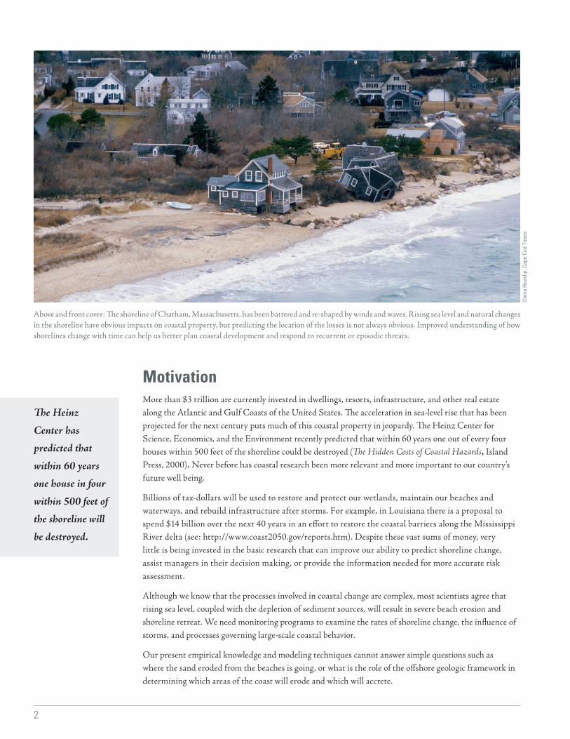
Above and front cover: The shoreline of Chatham, Massachusetts, has been battered and re-shaped by winds and waves. Rising sea level and natural changes in the shoreline have obvious impacts on coastal property, but predicting the location of the losses is not always obvious. Improved understanding of how shorelines change with time can help us better plan coastal development and respond to recurrent or episodic threats.
MotivationMore than $3 trillion are currently invested in dwellings, resorts, infrastructure, and other real estate along the Atlantic and Gulf Coasts of the United States. The acceleration in sea-level rise that has been projected for the next century puts much of this coastal property in jeopardy. The Heinz Center for Science, Economics, and the Environment recently predicted that within 60 years one out of every four houses within 500 feet of the shoreline could be destroyed (The Hidden Costs of Coastal Hazards, Island Press, 2000). Never before has coastal research been more relevant and more important to our country’s future well being.
Billions of tax-dollars will be used to restore and protect our wetlands, maintain our beaches and waterways, and rebuild infrastructure after storms. For example, in Louisiana there is a proposal to spend $14 billion over the next 40 years in an effort to restore the coastal barriers along the Mississippi River delta (see: http://www.coast2050.gov/reports.htm). Despite these vast sums of money, very little is being invested in the basic research that can improve our ability to predict shoreline change, assist managers in their decision making, or provide the information needed for more accurate risk assessment.
Although we know that the processes involved in coastal change are complex, most scientists agree that rising sea level, coupled with the depletion of sediment sources, will result in severe beach erosion and shoreline retreat. We need monitoring programs to examine the rates of shoreline change, the influence of storms, and processes governing large-scale coastal behavior.
Our present empirical knowledge and modeling techniques cannot answer simple questions such as where the sand eroded from the beaches is going, or what is the role of the offshore geologic framework in determining which areas of the coast will erode and which will accrete.
Stev
e H
easl
ip, C
ape
Cod
Tim
es
3
Although we know that
the processes involved in
coastal change are complex,
most scientists agree that rising sea level, coupled with depletion of sediment sources,
will result in severe beach erosion and
shoreline retreat.
More than just a beach problemBack barrier and estuarine tidal marshes are a critical component of our coastal ecosystem and are particularly vulnerable to accelerated sea-level rise. Tidal marshes are the dominant estuarine habitat along the East Coast of the United States, and they are ecologically and economically important as they filter and absorb terrestrial nutrients and pollutants, buffer coastlines from wave stress and erosion, and provide nurseries for fish and invertebrates.
Whereas researchers have been studying factors governing biomass production in marshes for many years, scientists have only recently embarked on programs to determine the scales of marsh accretion and erosion. We need to know the threshold rates at which marshes can no longer keep pace with rising sea level. If sea-level rise rates do double (or even quadruple as some more extreme model configurations project) over the next 100 years, tidal marshes and indeed coastal ecosystems worldwide will likely experience unprecedented changes. Many such ecosystems may disappear altogether.
These examples underline the fact that the coast is a complex system that cannot be reduced to the beach only. While beach erosion threatens property near the shoreline, it also profoundly influences marshes located in the backshore and regulates the exchanges of water, nutrients, and waste with the open ocean.
Furthermore, changes in the shoreline are inextricably linked to the geospatial framework of the entire coastal zone, from the onshore subaerial and lagoonal components, through the surf zone, and out onto the shelf. Most of this has never been mapped with adequate resolution.
The processes that shape our coasts occur on a variety of time and spatial scales. Linking these diverse processes is a challenge requiring a system-wide, multidisciplinary approach to tackling basic science questions, identifying the key processes involved in shoreline change, and modeling the interaction of these processes.
U.S
. Geo
logi
cal S
urve
y
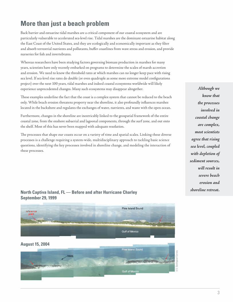
North Captiva Island, FL — Before and after Hurricane CharleySeptember 29, 1999
August 15, 2004

4
The workshop aimed to identify the outstanding issues in coastal change and devise a strategic plan to address them.
Bringing new tools and minds togetherRecent advances in technology have greatly improved our ability to monitor coastal evolution. We now have better scientific tools for mapping and monitoring the entire coastal system and to examine changes related to seasonal or individual events. The technologies include:
• dramatic improvements in seafloor mapping and imaging capabilities,• laser altimetry systems (LIDAR) for beach and nearshore mapping,• improvements in positioning through real-time kinematic (RTK) GPS,• high-resolution chirp seismic imaging,• ground-penetrating radar,• marine and terrestrial electrical resistivity,• on- and off-shore electromagnetic surveying.
We can also gather a more precise record of long-term trends in shoreline motion, which were previously identifiable only through societal records (maps and aerial photographs).
In April, we hosted a four-day short course and workshop at WHOI, the aim of which was to bring researchers together from different areas of the coastal arena and to learn what each believes to be the major obstacles to obtaining a greater understanding of shoreline change. The participants came principally (but not exclusively) from the New England area, as one of our goals was to create and tighten links among coastal researchers both locally within WHOI and regionally. The program included representatives from coastal management agencies as well as active researchers. Students from local universities attended and presented posters of their ongoing research.
The short course was open to all interested parties. In addition to the invited speakers, participants included WHOI and USGS scientists as well as students from several local universities. The meeting was
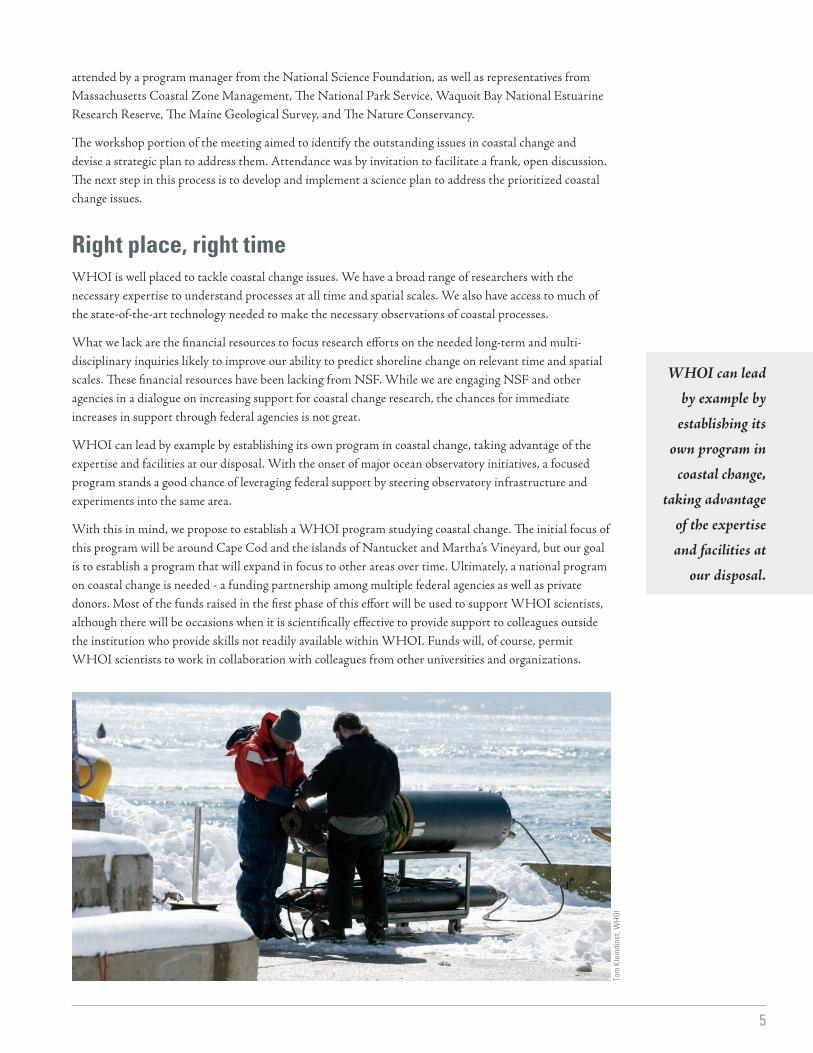
Above and lower right: WHOI scientist Rob Evans works with engineers Matthew Gould and Alan Gardner to test a seafloor electromagnetic surveying tool. This system is one of many new technologies developed and operated by WHOI which allow us to map and monitor the coastal system.
Tom
Kle
indi
nst,
WH
OI
5
WHOI can lead by example by
establishing its own program in
coastal change, taking advantage
of the expertise and facilities at
our disposal.
attended by a program manager from the National Science Foundation, as well as representatives from Massachusetts Coastal Zone Management, The National Park Service, Waquoit Bay National Estuarine Research Reserve, The Maine Geological Survey, and The Nature Conservancy.
The workshop portion of the meeting aimed to identify the outstanding issues in coastal change and devise a strategic plan to address them. Attendance was by invitation to facilitate a frank, open discussion. The next step in this process is to develop and implement a science plan to address the prioritized coastal change issues.
Right place, right timeWHOI is well placed to tackle coastal change issues. We have a broad range of researchers with the necessary expertise to understand processes at all time and spatial scales. We also have access to much of the state-of-the-art technology needed to make the necessary observations of coastal processes.
What we lack are the financial resources to focus research efforts on the needed long-term and multi-disciplinary inquiries likely to improve our ability to predict shoreline change on relevant time and spatial scales. These financial resources have been lacking from NSF. While we are engaging NSF and other agencies in a dialogue on increasing support for coastal change research, the chances for immediate increases in support through federal agencies is not great.
WHOI can lead by example by establishing its own program in coastal change, taking advantage of the expertise and facilities at our disposal. With the onset of major ocean observatory initiatives, a focused program stands a good chance of leveraging federal support by steering observatory infrastructure and experiments into the same area.
With this in mind, we propose to establish a WHOI program studying coastal change. The initial focus of this program will be around Cape Cod and the islands of Nantucket and Martha’s Vineyard, but our goal is to establish a program that will expand in focus to other areas over time. Ultimately, a national program on coastal change is needed - a funding partnership among multiple federal agencies as well as private donors. Most of the funds raised in the first phase of this effort will be used to support WHOI scientists, although there will be occasions when it is scientifically effective to provide support to colleagues outside the institution who provide skills not readily available within WHOI. Funds will, of course, permit WHOI scientists to work in collaboration with colleagues from other universities and organizations.
Tom
Kle
indi
nst,
WH
OI
6
Science Plan — Establish a program for coastal change research within WHOIThe first phase of this program will be to establish a Cape and Islands Coastal Change Natural Labora-tory. There are several key advantages – scientific and logistical – that make this field area an appropriate starting point. First, the Cape and Islands are scientifically compelling, offering a variety of shoreline con-ditions and a spectrum of shoreline erosion rates (for example, parts of Nantucket Island experience some of the highest rates of erosion anywhere in the U.S.). The area features the relatively pristine and high-en-ergy conditions of the Cape Cod National Seashore and the south shore of Martha’s Vineyard. There are numerous barrier-fronted embayments and estuaries. The area also features lower energy conditions that are accreting, and numerous examples where human influence has altered the sediment supply and trans-port patterns. Finally, there are areas of complexity such as mixed sediment beaches, cobble beaches, and inlets that are of interest to coastal managers.
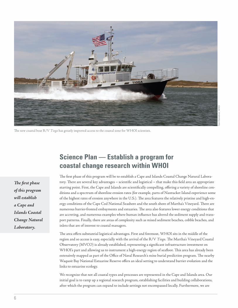
The area offers substantial logistical advantages. First and foremost, WHOI sits in the middle of the region and so access is easy, especially with the arrival of the R/V Tioga. The Martha’s Vineyard Coastal Observatory (MVCO) is already established, representing a significant infrastructure investment on WHOI’s part and allowing us to instrument a high-energy region of seafloor. This area has already been extensively mapped as part of the Office of Naval Research’s mine burial prediction program. The nearby Waquoit Bay National Estuarine Reserve offers an ideal setting to understand barrier evolution and the links to estuarine ecology.
We recognize that not all coastal types and processes are represented in the Cape and Islands area. Our initial goal is to ramp up a regional research program, establishing facilities and building collaborations, after which the program can expand to include settings not encompassed locally. Furthermore, we are
The first phase of this program will establish a Cape and Islands Coastal Change Natural Laboratory.
The new coastal boat R/V Tioga has greatly improved access to the coastal zone for WHOI scientists.
Tom
Kle
indi
nst,
WH
OI

7
Our long-term goal is to endow a program that can continue to support coastal change research
indefinitely at WHOI.
studying how the Cape will evolve in time, and there are locations globally that represent the future of the Cape. It will be important to our overall understanding to study these future Cape analogues.
Finally, we recognize that shoreline change is a global problem. Our goal is to improve our ability to predict shoreline change and this can only be useful if we can export our models to other locations. The only way to test these models is to work in different settings. But what is most important, is that we first develop a synergy through which the various disciplines represented at WHOI work together in a co-coordinated fashion in a small set of locations, gathering data that can be integrated into a common model of shoreline change. After several years of effort around the Cape and Islands, we will broaden our target areas to include shoreline types not included locally and to study areas that encompass conditions projected for the Cape and Islands in the future.
Research for today and tomorrowOur long-term goal is to endow a program that can continue to support coastal change research indefinitely at WHOI. Access to such a program will ensure that WHOI scientists have a competitive edge over colleagues at other institutions, ensuring excellence of research at WHOI and providing leverage for federal funds. It will also ensure that we are able to recruit and retain the very best scientists in the coastal arena.
We recognize that the funds required to fully endow a program are daunting (even though the net distribution will be far less than would be needed for a truly national program), and so we have estimated the costs that would be required to jump-start a program in the few two or three years, allowing us to make progress as endowment support is raised. Under this umbrella of the coastal change program, we have subdivided the request for support into three categories: facilities, sponsored research, and education/outreach. For each, we list the actual costs over the first few years of the program, assuming that startup funds will be supplied through direct contributions, and we list the endowment funds that would be needed to sustain this level of support.
The Martha’s Vineyard Coastal Observatory is one example of existing infrastructure that WHOI can use as leverage for our program.
Jayn
e D
ouce
tte,
WH
OI
8
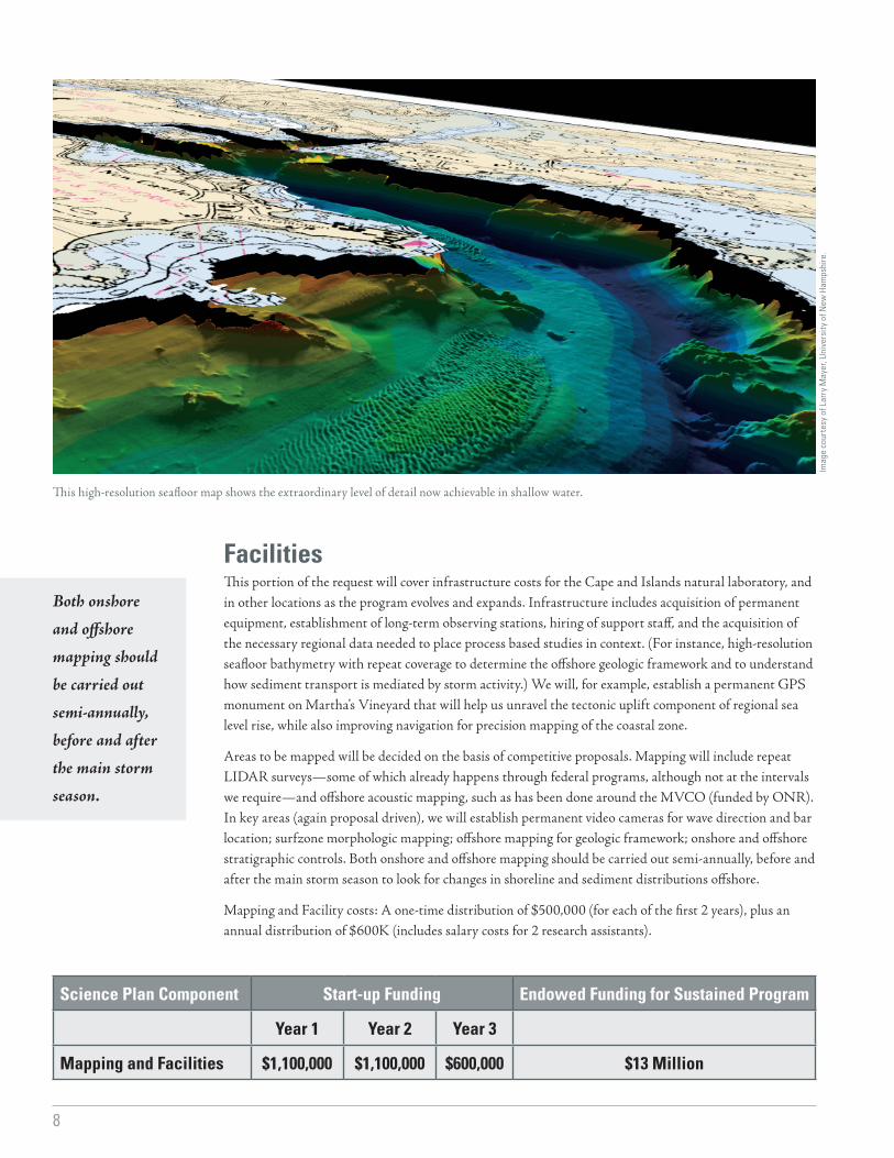
FacilitiesThis portion of the request will cover infrastructure costs for the Cape and Islands natural laboratory, and in other locations as the program evolves and expands. Infrastructure includes acquisition of permanent equipment, establishment of long-term observing stations, hiring of support staff, and the acquisition of the necessary regional data needed to place process based studies in context. (For instance, high-resolution seafloor bathymetry with repeat coverage to determine the offshore geologic framework and to understand how sediment transport is mediated by storm activity.) We will, for example, establish a permanent GPS monument on Martha’s Vineyard that will help us unravel the tectonic uplift component of regional sea level rise, while also improving navigation for precision mapping of the coastal zone.
Areas to be mapped will be decided on the basis of competitive proposals. Mapping will include repeat LIDAR surveys—some of which already happens through federal programs, although not at the intervals we require—and offshore acoustic mapping, such as has been done around the MVCO (funded by ONR). In key areas (again proposal driven), we will establish permanent video cameras for wave direction and bar location; surfzone morphologic mapping; offshore mapping for geologic framework; onshore and offshore stratigraphic controls. Both onshore and offshore mapping should be carried out semi-annually, before and after the main storm season to look for changes in shoreline and sediment distributions offshore.
Mapping and Facility costs: A one-time distribution of $500,000 (for each of the first 2 years), plus an annual distribution of $600K (includes salary costs for 2 research assistants).
Both onshore and offshore mapping should be carried out semi-annually, before and after the main storm season.
This high-resolution seafloor map shows the extraordinary level of detail now achievable in shallow water.
Imag
e co
urte
sy o
f Lar
ry M
ayer
, Uni
vers
ity
of N
ew H
amps
hire
.
Science Plan Component Start-up Funding Endowed Funding for Sustained Program
Year 1 Year 2 Year 3
Mapping and Facilities $1,100,000 $1,100,000 $600,000 $13 Million

9
Proposal Driven Research Our goal is to establish a competitive program within WHOI that is able to support a group of investigators at a substantial level and for a sustained period in order to realistically tackle shoreline change problems. This program should aim to invite a mix of large multi-disciplinary studies and smaller proposals for process-based studies at focus sites, while providing cost-sharing to allow WHOI scientists to work with colleagues at other institutions. Modeling studies are expected to be an integral component of the program, linked to observations made in the focus areas. The level of support should be in the region of $1 million per year. The program will be administered by the WHOI Coastal Ocean Institute, but will have a separate call for proposals specifically for research under this theme. Proposals for technology development related to coastal change issues will also be entertained.
Examples of research areas include:
• Identifying the role of rising sea level on shoreline change and how the shoreline changes on decadal time scales• Understanding the key processes of sediment transport in the coastal zone• Understanding how barrier systems evolve in a regime of rising sea level and the impacts on backbarrier
ecology• Quantifying sediment budgets and how changes in sediment supply affects coastal stability and ecology• Quantifying the economic impacts of coastal change
This program should aim to
invite a mix of large multi-
disciplinary studies and
smaller proposals for process-based
studies at focus sites.
Coastal researchers recover drifters—GPS receivers and radio beacons that float with currents—that give scientists a picture of surface flows.
Brit
t Rau
benh
eim
er, W
HO
I
Science Plan Component Start-up Funding Endowed Funding for Sustained Program
Year 1 Year 2 Year 3
Research $500,000 $700,000 $1,000,000 $20 Million

10
Education and OutreachIncreased research activity in the coastal environment offers an opportunity to educate the public, not only about the critical processes shaping our shorelines, but also about the importance of conducting marine research and science in general. The coastal ocean is the part of marine science that most of the public can relate to through direct experience. We can demonstrate the process of basic science and its application to a problem of obvious and direct relevance.
The shoreline is a readily accessible laboratory for a large portion of the K-12 and undergraduate population, offering great potential for field-based education programs tied in with on-going research efforts. Earth Science is already an important component of many K-12 curricula, but typically coastal processes are discussed in a non-quantitative context. An initiative in this area would provide an opportunity to better link coastal processes with other sciences in the curriculum, especially physics, biology and chemistry.
Given the current lack of NSF-style funding, we potentially face a severe lack of rigorously trained coastal researchers to attack the anticipated coastal problems outlined at the beginning of this plan. One of the major needs for the future is the training of the next generation of coastal scientists.
In many cases, there are models and science findings that could be used by coastal managers but that have not been effectively communicated to that audience. Clearly there is a need for better communication between scientists, coastal managers, and engineers on the existing science and its limitations. The national Sea Grant program already supports some work in this area, distilling scientific results and making them understandable to a non-technical audience through presentations and workshops. Yet, more needs to be done in this area, and support needs to be provided to scientists to work with those who are best able to communicate their results.
The coastal ocean is the part of marine science that most of the public can relate to through direct experience.
Jim O’Connell, a research specialist with WHOI Sea Grant and the Cape Cod Cooperative Extension, shows a group of teachers the Emory rod technique for monitoring beach and dune dynamics.
Jayn
e D
ouce
tte,
WH
OI

11
We may face a severe lack of rigorously
trained coastal researchers
to attack the anticipated
coastal problems.
This component of the program will seek funding to endow support for a graduate student and a postdoctoral fellow at WHOI who have specific interests in shoreline change. We also will establish and teach courses within the MIT/WHOI Joint Program that address coastal change. Finally, we will raise funds to provide increased support for outreach and communications efforts and to provide input to coastal managers through collaboration with the Sea Grant program as well as WHOI’s communications group.
Education and Outreach Costs (each year): Student fellowship in coastal change $70,000; Post-Doctoral Scholar in Coastal Change $80,000; Curriculum development and Teaching $100,000; and Outreach Budget $150,000 for 3 years.
Science Plan Component Start-up Funding Endowed Funding for Sustained Program
Year 1 Year 2 Year 3
Education and Outreach $400,000 $400,000 $400,000 $4.54 Million
Tom
Kle
indi
nst,
WH
OI
Fernanda Hoefel, a graduate of the WHOI/MIT Joint Program, who studied coastal processes and sediment transport on beaches for her PhD thesis, explains her work to WHOI Associate Pat Westcott.
12
While our initial research is regional in geographic focus, it is designed with an eye to the global problem of shoreline change.
DeliverablesOur program will feature integrated, basic research aimed at understanding the fundamental processes that shape the shoreline. The long-term goal of our program will be to contribute to an increased understanding of shoreline change that can be used to develop and provide:
• More accurate models of shoreline behavior.• Better assessments of risks to shoreline communities.• Better information for coastal zone managers.
Our program will be just one part of the national effort in this area. While our initial research is regional in geographic focus, it is designed with an eye to the global problem of shoreline change. We have chosen an initial geographic focus to ensure that scientists from different disciplines within WHOI work in the same area so that there is overlap in the time and spatial scales on which measurements are made, and that data on as many of the key processes shaping the shoreline are measured in the same setting. It is only through an approach such as this that an integrated model of coastal change can be developed that we might hope to export to other areas.
In the long term, an endowed program will allow us to move to other areas, and to work with colleagues at other institutions, taking our knowledge from the Cape and Islands and applying it elsewhere.
Her
man
C. M
iller
, Arm
y Co
rps
of E
ngin
eers
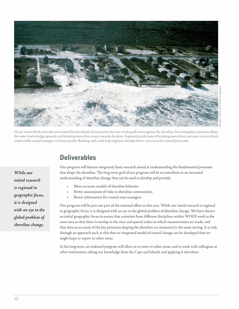
Ocean waters flood and wash over coastal barrier islands during storms because winds push water against the shoreline, low atmospheric pressure allows the water level to bulge upwards, and breaking waves force water towards the shore. Improved predictions of breaking-wave driven increases in water levels could enable coastal managers to better predict flooding, and could help engineers develop better structures for coastal protection.
13
Total for Coastal Change Research Program:
Science Plan Components
Start-up Funding Endowed Funding for Sustained Program
Year 1 Year 2 Year 3
Mapping and Facilities
$1,100,000 $1,100,000 $600,000 $13 Million
Research $500,000 $700,000 $1,000,000 $20 Million
Education and Outreach
$400,000 $400,000 $400,000 $4.54 Million
TOTAL $2 Million $2.2 Million $2 Million $37.54 Million
U.S
. Geo
logi
cal S
urve
y Co
asta
l and
Mar
ine
Geo
logy
Pro
gram
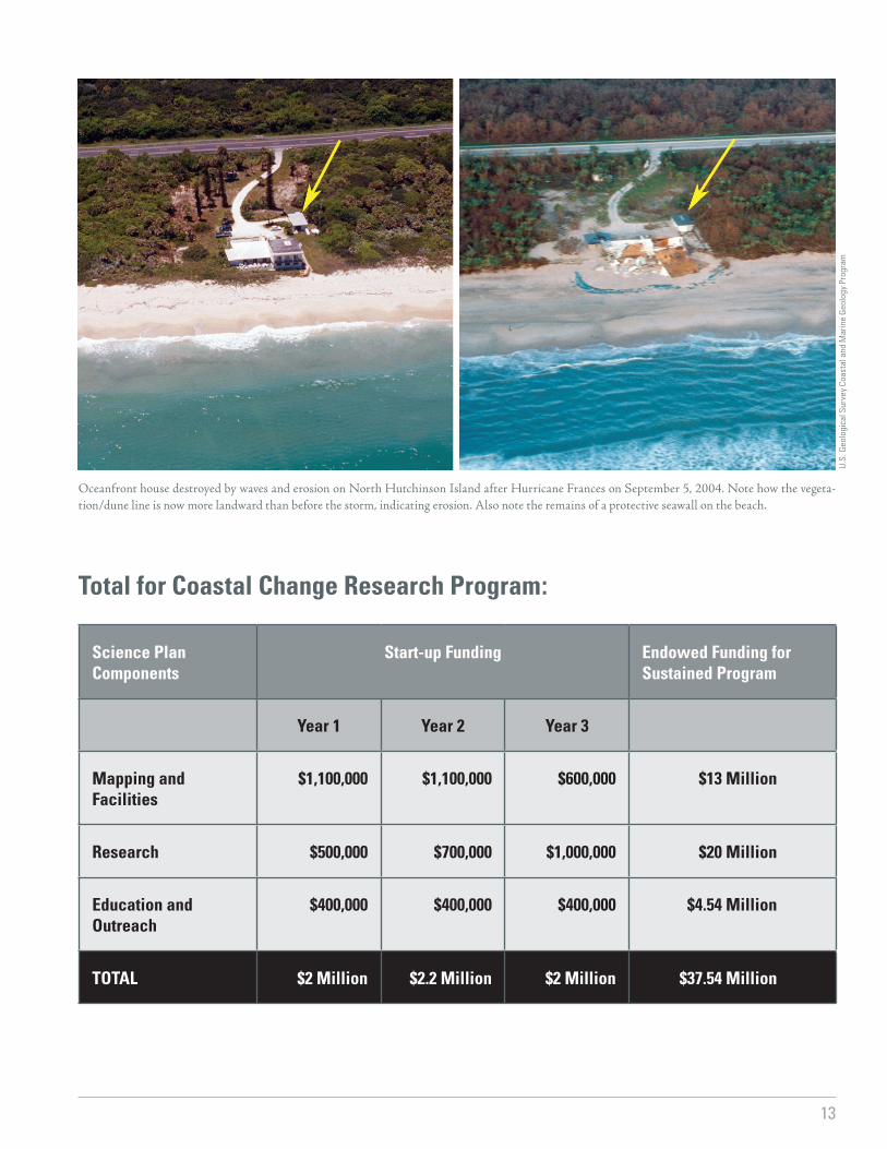
Oceanfront house destroyed by waves and erosion on North Hutchinson Island after Hurricane Frances on September 5, 2004. Note how the vegeta-tion/dune line is now more landward than before the storm, indicating erosion. Also note the remains of a protective seawall on the beach.

The Moving Shoreline: Establishing a Research Program on Coastal ChangeDeveloped by the Coastal Ocean Institute of Woods Hole Oceanographic Institution
Woods Hole Oceanographic Institution is a private, non-profit research facility dedicated to the study of marine science and to the education of marine scientists.
It is the largest independent oceanographic institution in the world.
For more information, contact Jane Neumann
Woods Hole Oceanographic Institution, Woods Hole, MA 02543
(508) 289-3319 • [email protected]
www.whoi.edu/institutes/coi/
September 2004