The Microstratigraphy of the Roseland Quarry (Early …polsen/nbcp/olsen_75_sm.pdf · 1.1 Area of...
104
The Microstratigraphy of the Roseland Quarry (Early Jurassic, Newark Supergroup, New Jersey) Paul Eric Olsen 1975 Open File Report, Essex County Park Commission, Newark, New Jersey
Transcript of The Microstratigraphy of the Roseland Quarry (Early …polsen/nbcp/olsen_75_sm.pdf · 1.1 Area of...

The Microstratigraphy of the Roseland Quarry (Early Jurassic, Newark Supergroup, New Jersey)
Paul Eric Olsen
1975
Open File Report, Essex County Park Commission, Newark, New Jersey

Preface
This paper is the first s t e p i n p r e s e n t a t i o n
of information r e s u l t i n g from seven years of work on
the Roseland Quarry. During t h i s time I have rece ived
h e l p from many people, e s p e c i a l l y D r . John Ostrom, D r .
Keith Thornson, D r . Carl Waage, D r . John Rogers, D r , Donald
Baird, D r . Bobb Schaeffer , Bruce Cornet, Tony Lessa, Robert
Sa lk in , the Essex County Park Commission, and the Walter
Kidde & Company 1nc.I would a l s o l i k e t o thank S tan
Rachootin f o r reading the manuscript and supplying many
helpful suggest ions which s u b s t a n t i a l l y improved it.
INTRODUCTION
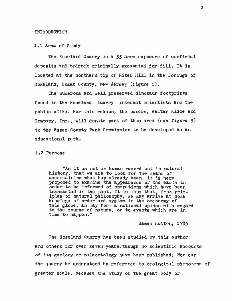
1.1 Area of Study
The Roseland Quarry is a 55 acre exposure of s u r f i c i a l
deposi ts and bedrock o r ig ina l ly excavated f o r f i l l . It is
located a t the northern t i p of Riker H i l l i n the Borough of
Roseland, Essex County, New Jersey ( f igure 1).
The numerous and well preserved dinosaur foo tp r in t s
found i n the Roseland . Quarry i n t e r e s t s c i e n t i s t s and the
public a l i ke . For t h i s reason, the owners, Walter Kidde and
Company, Inc., w i l l donate pa r t of th5s a rea (see f i gu re 9)
t o the Essex County Park Commission t o be developed as a n
educational park.
1 .2 Purpose
"As it is not i n human record bu t i n na tura l h i s to ry , t h a t we a r e t o look f o r the means of ascer ta in ing what has a l ready been, it is here proposed t o examine the appearence of the e a r t h i n order t o be informed of operations which have been transacted i n the pas t . It is thus t h a t , from pr ic- i p l e s of na tura l philospphy, we may a r r i v e a t some knowlege of order and system i n the oeconomy of t h i s globe, a n may form a r a t i o n a l opirion with regard t o the course of nature, or t o events which a r e i n time t o happen."
James Hutton, 1785
The Roseland Quarry has been studied by t h i s author
and others f o r over seven years, though no s c i e n t i f i c accounts
of its geology or paleontology have been published. Nor can
the quarry be understood by reference t o geological phenomena of
g r e a t e r sca le , because the study of the g r e a t body of

sediments and volcanics t o whidi the quarry bedrock belongs,
the Newark Supergroup, is a t present undergoing major
re in te rpre ta t ion . The discovery of new f o s s i l l o c a l i t i e s
and the app l ica t ion of new d i r ec t ions of inquiry have made
re levan t review a r t i c l e s obsole t e . This paper surveys work
done t o date t h a t may be of use t o the Essex County Park
Commissfeion and in te res ted s tudents of geology and paleo-
ecology u n t i l the many papers now i n preparat ion a r e i n
p r i n t . 1.3 Method and Results
" In te rpre ta t ion rushes t o the fo re f ron t as the obl igat ion pressing upon the putat ive wise man. Laudable as the e f f o r t a t explanation is i n i t s e l f , it is t o be condemned when it runs before a se r ious inquiry i n t o the phenomenon i t s e l f . A dominant d i spos i t ion t o find out what is, should precede and crowd as ide the question, "How came t h i s so?" First full f a c t s , then in te rpre ta t ions . "
T C Chamberlin, 1965.
This paper is divided i n t o four major parts t Geology,
Paleontology, Synthesis, Future Development. Each p a r t c o n s i s t s
of a n introduction, a c r i t i q u e of the re leven t nomenclature,
a presentationof observation^ and a n in t e rp re t a t i on of the
evidence. This scheme allows f o r easy reference, bu t more
importatly, it permits the reader t o weigh the i n t e rp re t a t i ons
aga ins t the o r ig ina l observations and, perhaps, t o derive
a l t e r n a t i v e theor ies .

Part 1
GEOLOGY
2. St ra t igraphy
2.1 S t ra t ig raphic Nomenclature and Class i f i ca t ion
" A l l s t r t a t i g r a p h i c u n i t s require d i s t i n c t i v e names or comparable designations i n order t h a t they may be iden t i f i ed and d i f f e r en t i a t ed from each other."
"Once we deviate from the o r ig ina l meanings of the terms and abandon the pr inciple of p r i o r i t y , we lose our hold on the only l i f e l i n e t h a t can save us from the slough of con f l i c t i ng opinion. "
W o J . Arkel l
A meaningfull discussion of a geologic phenomena can
not begin u n t i l a su i t ab l e nomenclature is devised. Tha t
confusion a r i s i n g from semantics might be avoided, a r ev i s ion
of the re leven t terminology is presented i n sec t ions 2.2 - 2.4.
The American Commission on S t ra t ig raphic Nomenclature
was es tabl ished i n 1946 t o develop a concise and meaninful
s e t of terms and br ing order out of 150 years of chaos. The
r e s u l t of t h i s commission is the Code of S t ra t ig raphic Nomen-
c l a t u r e which was published i n the Geological Socie ty of
America Bul le t in (1961, v. 45, no. 5, p. 645-660) and aga in
i n Krumbine and Sloss (1963). The code d i s t ingu ishes between
terms which involve in t e rp re t a t i on and those which do not.
Spec i f ica l ly they s t a t e (1947) t
"The main source of d i f f i c u l t y i n making a a consis tent , thoroughly sound approach t o c l a s s i f i c a t i o n and nomenclature of s t r a t i g raph ic u n i t s as a whole is prevalent f a i l u r e by geo log is t s t o exclude concepts of time from considerat ion of the object ive data on
which alone properly defined rock un i t s a r e d i f fe ren t ia ted . Recognition of e s s e n t i a l diet- inct ions i n the nature of time u n i t s is needed as a basis for s a t i s f a c t o r y s t r a t i g raph ic c l a s s i f i c a t i o n and terminology. "
Sections 2.1 through 2.4 may seem far removed
from the i n t e rp re t a t i on of the geology of the Roseland Quarry
Quarry; however, the importance of a sound nomenclature
cannot be over s t ressed . The following r ev i s ion of
s t r a t i g raph ic terminology is e s s e n t i a l t o the understanding
of the discussions and interepre-fcations it precedes.

Figure 1. Geographic p o s i t i o n of t h e Roseland Q u a r r y .

2 STRATIGRAPHIC NOMENCLATURE
2.1 S t r a t i g r a p h i c Nomenclature of the Newark Supergroup.
1 A t l e a s t 15 i s o l a t e d , e longate bas ins of sedimentary
and volcanic rocks outcrop i n the Piedmont physiographic
province of t h e e a s t e r n c o a s t of North America (see f i g u r e 2 ) .
The long axes of these bas ins roughly p a r a l l e l the Appalachian
Mountains. The rocks of these bas ins present a u n i f i e d l i t h o -
logy and s t r u c t u r e . Red beds (see s e c t i o n 2 ) a r e the most
common sedimentary depos i t s and b a s i c i n t r u s i v e s and t h e o l e i i t i c
b a s a l t s a r e the dominant volcanics . These unconf ormably
overlay Precambrian and Paleozoic sedimentary, volcanic , and
metamorphic rocks and a r e , i n t u r n , ove r l a in by pos t -Jurass ic
rocks of the Coas ta l P la in , P le is tocene depos i t s , or Recent
alluvium and s o i l s .
Redf i e l d (1856) named the rocks of these bas ins the
Newark Group ( a t e r m e n j o y i n g wide usage f o r over a
century [Russel, 1892; Kline, 19621 ). Kline (1962) r e s t r i c t e d
Newark Group t o the formations of the Newark Basin because
some workers have used the term i n a t ime-s t ra t igraphic sense.
The rocks formerly considered Newark Group of the Maritime '
Provinces of Canada ( ~ u s s e l , 1892) were renamed t h e Fundy
Group line, 1962) and more r e c e n t l y , Thayer (1970) has
l a b e l l e d the rocks of the Dan River Basin t h e Dan River Group.
1 Basin is used here as a convention f o r a body of rock. No s t r u c t u r a l impl ica t ions o ther than s e p a r a t i o n from surround- ing rocks a r e intended.

The rocks of each b a s i n a r e g e n e r a l l y divided i n t o
l i t h o l o g i c a l l y d i s t i n c t formations. Ind iv idua l group names
f o r t h e rocks of each b a s i n a r e u s e f u l and i n agreement with
t h e Code o f s t r a t ig raph ic Nomenclature (C .S. N. ) ; however, t h e 3 Newark Group cannot be composed of o ther groups . The obvious
r e l a t i o n of a l l the rocks of these bas ins r e q u i r e s a n encom-
pass ing rock-s t r a t ig raph ic term of appropr ia t e rank. I pro- 4
pose the rank of the name Newark be r a i s e d t o Supergroup i n
order t o preserve the o r i g i n a l and familiar meaning of Redf i e l d *s
des igna t ion and a l low the formations of ind iv idua l b a s i n s t o
be included i n s p e c i f i c group names. Table I lists t h e sug-
ges ted group names f o r the depos i t s of the bas ins of the Newark
Supergroup (see f i g u r e 2 ) . Most of these de r ive from w e l l
5 6 known b a s i n names unless t h e r e is a c l e a r p r i o r i t y (eg . Fundy 7 Group of line), the term is preoccupied , or the b a s i n geology
sugges ts a new term of d i f f e r e n t usage (see foo tno tes of Table
I f o r spec i f i c explanat ions ) . A s out l ined above and i n Table I, the Newark Supergroup
c o n s i s t s of f i f t e e n rock- .uni t s of group s t a t u s , f o u r i s o l a t e d
and undivided f ormationsi,. t h r e e t i n y , u n d i f f e r e n t i a t e d u n i t s
south of the Farmville Group, a t l e a s t t e n subsurface u n i t s
2 American Commission on S t r a t i g r a p h i c Nomenclature , 1961, Code of S t r a t i g r a p h i c Nomenclature, Am. Assoc . P e t r o l . Geol. Bull . v. 45, no. 5, p. 645-660, A r t i c l e 9a. This paper w i l l be r e f e r r e d t o i n t h i s paper as the C.S.N..
4 Supergroup is suggested by the C.S.N., Arlkicle 9e, f o r a formal assemblage of r e l a t e d groups or formations and groups.
' ~ u s s e l (1892) g i v e s a l i s t of the b a s i n names and t h e i r h i s t o r i e s .
bid., A r t i c l e 11. bid., A r t i c l e 1 1 ~ .

P. Olsen 1975

i n t h e Coas ta l P la in , and probably the e a r l y Mesozoic r e d
beds a t the base of c e r t a i n bas ins on the c o n t i n e n t a l s h e l f .
Table I
Suggested and Accepted Names of t h e Units Included i n Newark Supergroup and Key t o Figure 2.
Number i n Rock-Stratigraphic Term Bas i n Name Figure
Uni ts Exposed i n Peidmont
1 Chatham ~ r o u ~ ~
2 Davie County Formation
3 Dan R i v e r ~r oupc
4 u n d i f f e r e n t i a t e d ~ e w a r k ~ Supergroup
5 Farrnville Group
6 Richmond Group f
7 Sc o t t s v i l l e Group
8 h Tay lo r sv i l l e Group
9 Culpe per Group
10 C onewago Group 3
11 Novacaesarea Group k
Durham, Deep River and Wadesboro
Davie County b
Dan River and Danville
Richmond
sc o t t s v i l l e g
T a y l o r s v i l l e
culPeper
Ge t tysburg
Newark
1 2 S outhbury Group southbury1
13 Hartford Group Hartford .Basinm
14 Cherry Valley Formation Cherry va l l eyn
15 Greenfield ~ r o u ~ ' Deerf i e l d
16 Fundy ~ r o u ~ ^ Aca i d i a n
1 7 Chedabuc t o Formation chedabuctoq
(cont . )

Units known t o e x i s t below the Coas ta l P la in .
18 Dunbarton Group
1 9 Florence Group ~ l o r e n c e '
20 Laurens County Diabase t no b a s i n naxe
21 Montgomery County IIiabaseu no b a s i n name
22 Appling County 3asaltV no b a s i n name
23 undifferen4iated Newark no b a s i n name Supergroup
24 und i f fe ren t i a t ed probable no b a s i n name Newark Supergroup
25 und i f fe ren t i a t ed robable 9 no b a s i n name Newark Supergroup
26 und i f fe ren t i a t ed robable t? no b a s i n name Newark Supergroup
27 und i f fe ren t i a t ed ggobable Albemarle Embayment Newark Supergroup
28 und i f fe ren t i a t ed ~ o b a b l e Sa l i sbury Embayment Newark Supergroup
In fe r red Newark Supergroup depos i t s on Cont inenta l She l f .
29 Probable Newark ~ u ~ e r ~ r o u ~ ~ ~ Gulf of Maine
30 Possible Newark Supergroup E a s t of F lo r ida , Ge org ia , .and S outh Carol ina
31 Possible Newark Supergroup Baltimore ~r oughee
32 Possible Newark Supergroup Georges dank Trough f f
33 Poss ib le Newark Supergroup South Whale, Whale, Horeshoe , J anneDIArc,
g l and Carson
E a r l y Mesozoic Rocks probably not i n Newark Supergroup.
hh 34 Pre-Smakover Red Seds Gulf Coast -3asin
Notes : a The rocks of the Durham, Deep River , and Wadesboro Basins
err, 1875; Russel, 1892; Prouty, 1926) a r e here considered as one group because the bas ins a r e only s u p e r f i c i a l l y s e r a t e d by a t h i n cover of Coas ta l P l a i n sediments. Ernrnonsl (1857)

Chatham Group ( o r i g i n a l l y s e r i e s ) may be used f o r the rocks of these bas ins .
c he rocks of the Davie County Basin ( ~ r o w n , 1932) have n o t been divided i n t o ind iv idua l format ions (Thayer , 1968,1970).
c Thayer, 1970. 'Russel, 1892. e Russel, 1892.
'shaler and Woodworth (1897-98) divided the rocks of the Richmond .Basin i n t o the Tuckahoe Group and Ches te r f i e ld Group. To conform t o the group usage i n o ther Newark u n i t s it is suggested t h a t a l l the formations i n the Richmond d a s i n be termed the Richmond Group. It is, however, noted t h a t the aforementioned group names were the first t r u e l y r o c k - s t r a t i g r a - phic terms app l i ed t o the rocks of the Richmond Basin (Russel, 1892).
"Robert Weens, M.S. i The Newark G e t t sburg, and Culpeper Basins (numbers 11,
10 , and 9 r e s p e c t i v e l y y a r e connected by narrow sedimentary necks (VanHouten, 1969). Three separa te group names a r e pro- posed f o r the rocks of these bas ins because of the l a c k of homotaxali ty between formations (C.S.N. A r t i c l e 2a) . The term Culpeper Group is derived from the b a s i n name. (Russel, 1892).
he name Gettysburg cannot be used as the group name because it is used f o r Gettysburg Shale. The Conewag0 Group is proposed t o include a l l the formations of the Gettysburg Basin. The name is taken from B i g and L i t t l e Conewago Creeks a long which the re a r e numerous exposures, (c.s.N. A r t i c l e 2 a ) .
h e term Novacaesarea Group (Pre-Colonial name f o r New Je r sey , suggested by Dr. Donald Bai rd) is proposed f o r the rocks of the Newark Basin (van Houten, 1969). The term "Newark" cannot be used f o r a group name s ince it is the name of t h e Supergroup (c.S.N. A r t i c l e 9a) .
M u s s e l , 1892. m Cornet, 1973.
he Hartford and Deerf ie ld Basins seem t o be connected by a narrow sedimentary neck, ( ~ a i n , 1932 ) f o r the reasons descr ibed i n footnote *it these should have two separa te group names. Deerf ie ld cannot be used as the group name because it is preoccupied by the Deerf i e l d Basalt. The Greenfield Group is porposed t o include a l l the formations of the Deerfoeld Basin. Greenfield is the l a r g e s t c i t y i n the Deerf i e l d Sas in .
-
'the Newark Supergroup of the Maritime Provinces of Canada poses i n t e r e s t i n g s t r a t i g r a p h i c and nomenclatural problems. Kline (1962) includes a l l the Newark Supergroup outcrops i n New 3runswick and Nova Sco t i a i n h i s Fundy Group. Kline 's Chedabucto Formation is i n a n i s o l a t e d b a s i n and should no t be included i n the Fundy Group. The rocks of Grand Manan I s l and , Po in t Lepreau, S t . Martins, and Waterside, i n New Brunswick seem t o be connected t o the Annapolis and M i n a s Basin rocks by continuous Newark Supergroup sediments beneath the Bay of Fundy.

� he Chedabucto Formation remains as a separa te format ion i n a n i s o l a t e d b a s i n line, 1962).
~ a r i n e and S i p l e , 1974, ' s iPle , 1959. t Marine and S i p l e , 1974. u ~ b i d .
v I b i d .
74 Ib i d .
w Ib i d .
aa Ib id .
y ~ b i d .
^ ~ i n a r d e t a l , 1974. cc In fe r red Newark Supergroup on the basis of se ismic
d a t a (Ballard-and Uchupi, 1974 ) . dd In fe r red Newark Supergroup on the basis of seismic data
( ~ i n a r d e t a l , 1974). ee
Infer red on the basis of seismic data. Seems t o be conformably o v e r l a i n by Ear ly J u r a s s i c evapor , i tes (Emery and Uchupi, 1972).
^~moco L td . and Imperial O i l L td . , S t a f f (1974) descr ibe f i v e bas ins on the Grand Banks with basal red beds conformably over l a in by Ear ly J u r a s s i c marine and non-marine c l a s t i c and evapor i tes . TBe basal beds, a t l e a s t , should be included i n t h e Newark Supergroup.
hh The Pre-Smakover r ed beds occur over a very l a r g e a r e a which does not have the s t r u c t u r e t y p i c a l of Newark Supergroup depos i t e s , ( ~ a r i n e and S i p l e , 1974).

2.2 S t r a t i g r a p h i c Nomenclature of the Novacaesarea Group.
The Novacae s a r e a Group c ons is ts of mainly c las t i c
r e d and non-red sedimentary rocks and ex t rus ive and i n t r u s i v e
volcanics preserved i n the southwest trending Newark B a s i n , which
extends from Rockland County, New York t o nor theas te rn
Lancaster County, Pennsylvania (see f igure 3 ). The Newark
and Gettysburg as ins a r e connected by a narrow sedimentary
neck. The d i v i s i o n between the bas ins is a r b i t r a r i l y
taken t o be t h e narrowest p a r t of the neck. The te rminat ion
of the Novacaesarea Group is defined as where the Robeson
Conglomerate (McIaughlin, 1939, see page 1 6 ) pinches out
i n the New Oxford Formation and Gettysburg Shale. This
d e f i n i t i o n is c o n s i s t a n t with A r t i c l e 6 of t h e Code of
S t r a t i g r a p h i c Nomenclature (American Commission on S t r a t i g -
r aph ic Nomenclature ) . The Newark Basin is broken i n t o a t l e a s t f o u r major
f a u l t blocks. The sedimentary and assoc ia ted
volcanics , i n these f a u l t blocks d i p , with v a r i a t i o n , t o
t h e northwest. Furthermore, the western beds a r e folded
i n t o a r e g u l a r s e r i e s of g e n t l e , open a n t i c l i n e s and
s y c l i n e s (sanders , 1963).
Precambrian and e a r l y Paleozoic rocks of the New
England Upland border t h e Novacaesarea Group a long its
n o r t h e a s t and nor thwes t margins. The latter overlays and is
bordered by Paleozoic and minor Precambrian rocks of t h e Blue
Ridge and Piedmont Provinces t o the sou thes t and southwest.
Cretaceous and younger Coas ta l P l a i n depos i t s over lap p a r t

North newago Group
THE
T H E
F i g u r e 3
NOVACAESAREA GROUP of
NEWARK SUPERGROUP s c a l e 20 miles --

of t h e Novacaesarea Group along its southeas t edge. The
nor thern t h i r d of t h e Newark Basin is mantled by P l e i s t -
ocene g l a c i a l depos i t s .
Although the p reva i l ing view (Van Houten, 1969) is
t h a t the e a s t e r n edge of the Novacaesarea Group overlaps
Pale oz o i c and Precambrian basement rocks while the western
border is a high angle f a u l t of g r e a t displacement, t h e r e is
considerable evidence ( F a i l l e , 1973 ) t h e western edge south of
Cushatunk Mountain may be a n over lap i n many places. Broad
g e n e r a l i s a t i o n s , t h e r e f o r e , do not hold (see s e c t i o n 5.3).
Kummel (1897) d iv ides t h e rocks of t h e Newark Basin
i n t o th ree formations : the Stockton, Lockatong, and Brunswick.
The Stockton Formation, named f o r c h a r a c t e r i s t i c exposures
near Stockton, New Jersey , c o n s i s t s of red s i l t s t o n e s ,
sandstones and conglomerates, and w e l l so r t ed buff arkose
and poorly so r t ed conglomerate. There a r e minor amounts of
g r a y and b lack s i l t s t o n e s near the top. It is about 5000 f e e t
t h i c k along t h e Delaware River i n t h e western f a u l t block,
t h i n i n g towards the e a s t e r n f a u l t blocks, and t o the n o r t h e a s t
and southwest. The Stockton Formation r e s t s unconformably
on t h e basement rocks.
The Lockatong Formation is named f o r exposures along
Lockatong Creek, nor th of Stockton. About 3750 f e e t (MCUU-
g h l i n , 1945) of Lockatong Formation occurs a t i ts type
s e c t i o n . This formation is almost e n t i r e l y composed of
c y c l i c u n i t s of black, gray , and minor red s i l t s t o n e s (van
Houten, 1969). It t h i n s and i n t e r d i g i t a t e s with the overlying
formation (Passaic Formation of t h i s r e p o r t ) i n a l l d i r e c t i o n s
away from the type exposures. The Lockatong Formation is

absen t a t the nor the rn and southern ex t remi t i e s of t h e Newark
Basin where Stockton i n t e r f inge r s with the overlying (Passaic )
formation.
The beds s t r a t i g r a p h i c a l l y above t h e Lockatong
Formation or , where t h i s is absen t , t he Stockton Formation,
have been termed t h e Brunswick Formation by Kummel (1897)
a f t e r exposures a long t h e R a r i t a n River near New Brunswick,
New Jersey. The Brunswick Formation can be thought of as
two d i f f e r e n t , major u n i t s : lower and upper Brunswick arton on,
1889; McLaughlin, 1933, 1943, 1944, 1945; Baird and Take, 1959;
and Van Houten, 1969). The lower Brunswick c o n s i s t s mostly
of r e d s i l t s t o n e s , sandstones, conglomerates, and l a t e r a l l y
p e r s i s t e n t beds of Lockatong-like b lack and g r a y s i l t s t o n e s
(Kummel, 1897; Mclaughlin, 1943 ) . The upward increas ing
th ickness of c y c l i c r e d u n i t s marks the t r a n s i t i o n from the
Lockatong t o lower Brunswick Formations (van Houten, 1969;
see f i g u r e 2 ) . The upper Brunswick Formation, on t h e o the r
hand, c o n s i s t s of t h r e e major volcanic u n i t s termed t h e
Watchung Basalts (Darton, 1889) and interbedded and overlying
sedimentary u n i t s which have been thought of as i d e n t i c a l t o
the Lower Brunswick Formation (~ummel, 1897). My r e c e n t
mapping i n d i c a t e s t h a t each of the Watchung 3asalts and major
interbedded and over l y i n g sedimentary u n i t s a r e l i t h o l o g -
i c a l l y d i s t i n c t from each o the r and t h e lower Brunswick
Formation and can be mapped a t a s c a l e of 1 : 25,000. I
propose t h e terms Brunswick Formation (~ummel, 1897) and
7 ~ . s . ~ . , A r t i c l e 6d.

Watchung Basalts (Darton, 1889) be dropped and t h e i r
components subdivided t o form seven new formations as
Lehmann (1959) has f o r the Hartford Group and as Kline
(1962) has f o r the Fundy Group ( r e s t r i c t e d ) . 8
Table I1 lists the formations of the Novacaesarea
Group according t o Kummel (1897) and Darton (1889) and t h i s
author.
Table I1
Formations of the Novacaesarea Group.
Kummel (1897, Darton (1889)
Brunswick Formation t h i r d Watchung Basalt Brunswick Format ion second Watchung Basalt Brunswick Formation first Watchung Basalt Brunswick Formation Lockatong Formation Stockton Formation
Boonton Formation Hook Mountain Towaco Format ion Preakness Mountain Basalt F e l t v i l l e Formation Orange Mountain Basalt Passaic Formation Lockatong Formation Stockton Formation
f bid., Ar t i c l e l4b.
h he terms Boonton Formation, Hook Mountain Basalt, and Towaco Formation were suggested by informal u n i t desig- nat ions used by Baird and Take (1959) and Baird (Pers. Corn.). The type sec t ion of the Passaic Formation is along I n t e r s t a t e R t . 80 i n Passaic, Pat terson, and Cl i f ton, New Jersey. That of the Orange Mountain Basalt is along I n t e r s t a t e R t . 280 i n E a s t Orange, New Jersey. The type sec t ion of the F e l t v i l l e Formation is located i n the Watchung Reservation on the s i t e of the old v i l l age of F e l t v i l l e , Union County. New Jersey. The type sec t ion of the Towaco Formation is the Roseland Quarry, Roseland, New Jersey. The basalt exposures along I n t e r s t a t e R t . 80 a t Lincoln Park, New Jersey is the type sec t ion of the Hook Mountain Formation. The type sec t ion of the Boonton Formation is along the Rockaway River i n Boonton, New Jersey.

A de ta i led descr ip t ion of these new formations is given
elsewhere Olsen, M.S. ). The Towaco Formation w i l l be desr-
ibed i n d e t a i l l a t e r i n t h i s r e p o r t ( sec t ion 3 ).
The northern and southern extremit ies of the Novac-
aesarea Group a r e major a r ea s of conglomerate (see f igure 3 ) . The northern conglomerate a r e a , r e s t r i c t e d t o the western
two-thirds of the Novacaesarea Group, extends south from
Stony Point, New York and edges out near Glen Rock, New
Jersey. Large tongues of conglomerate continue as far south
as Passaic, New Jersey, however. The southern conglomerate
a r ea occupies p r a c t i c a l l y the e n t i r e Newark Basin west of
the Schuylki l l River and pinches out i n the formations of
the Conewago Group, i n the Gettysburg Basin. Both conglo-
merate a r eas a r e l a t e r a l equivalents of and continous w i t h
the Passaic Formation.
The northern conglomerate a r ea has not been wel l
s tudied. Kummel (1899) and Van Houten (1969) have discussed
and Savage (1968) has mapped and described the conglomerate
a r ea i n New York, but the ex ten t of the conglomerate a r ea
i n New Jersey has been ignored and has been t ena t ive ly napped
by t h i s author (see f igure 3 ).
I n contas t , the southern a rea of conglomerate has
a t t r a c t e d considerable a t t e n t i o n since it was discovered
and napped by McLaughlin (1939). He named it the Robeson
Conglomerate. The mapping has been elaborated by Geyer
e t a].. (1958, 19631, Gray e_b a].. (19581 Johnston (1966).
and McLaughlin and Gerhard (1953 ) . Glaeser (1963, 1966)
d i d not use McLaughlin8s term fo r the conglomerate and named

t he same rocks the Hammer Creek Formation. Glaeser s t a t e s
t h a t the Hammer Creek Formation is l i t h o l o g i c a l l y d i s t i n c t
from t h e Stockton Formation, New Oxford Formation, Ge t tysburg
Shale , and Passa ic Formation (i3runswick Fm. ) and, t h e r e f ore ,
r e q u i r e s format ional rank.
The term Robeson Conglomerate ( ~ ~ L a u g h l i n , 1939)
has c l e a r p r i o r i t y over Hammer Creek Formation (Glaeser,
1963). It is, the re fo re , suggested t h a t the term Hammer
Creek Formation be discarded i n favor of Robeson Conglomerate
i n accordance with the Code of S t r a t i g r a p h i c Nomenclature. 10
The maps of Geyer e_t a. (1958, 1963), Geyer (1965).
Gray (1958) and Johnston (1966) and Glaeser ' s (1963) type
s e c t i o n f o r h i s Hammer Creek Formation show t h a t the
Robeson Conglomerate is i d e n t i c a l , i n terms of l i t h o l o g y
and f a c i e s r e l a t i o n s , t o the nor thern conglomerate a r e a ,
tongues of which a r e present i n the type s e c t i o n of the
Passa ic Formation type s e c t i o n . It is c l e a r t h e
Robeson Conglomerate and t h e nor the rn conglomerate a r e a
a r e simply coarse , l a t e r a l equ iva len t s of th-e Passa ic
Formation. I propose t h a t the nor the rn a r e a of conglomerate
be termed t h e Ramapo Conglomerate. Furthermore, the Robeson
and Ramapo Conglomerates should be regarded as members of the
Passa ic Formation. To g r a n t these members format ional rank
i n f l a t e s the a l r e a d y complex nomenclature of the Novacaesarea
Group and d i s rega rds the in t imate l i t h o l o g i c and s p a t i a l
r e l a t i o n s h i p between coarse and f i n e f a c i e s of t h e Passa ic
Formation.
"c.s.N., A r t i c l e 11.

2 .3 S t r a t i g r a p h i c Nomenclature of the Towaco Formation.
The term Towaco orm mat ion" (Olsen, M.S. ) is appl ied
t o the predominately c l a s t i c r e d and non-red sedimentary
rocks found below the Hook Mountain basalt and above the
Preakness Mountain Basalt. The Towaco Formation, unl ike
t h e underlying u n i t s , is exposed only i n the Passa ic
Syncline ( see figure 4 ). The l a r g e s t exposure of the
Towaco Formation is the Roseland Quarry which Olsen (M.S. )
has designated as t h e type sec t ion . About 300 f e e t of the
upper Towaco Formation is exposed a t t h i s l o c a l i t y . The
t o t a l th ickness of the formation near this type s e c t i o n is
est imated a t 1200 f e e t .
The Towaco Formation is c h a r a c t e r i z e d by c y c l i c ,
l a t e r a l l y p e r s i s t a n t non-red u n i t s . The mean th ickness of
these u n i t s is 41 f e e t . The non-red u n i t s a r e separa ted by red
u n i t s with a mean th ickness of 54 f e e t . Unlike most
Novacaesarea formations, the Towaco format ion is only one -half
r e d . It is poss ib le t o map these u n i t s as McLaughlin (1933,
1943, 1944. 1945, 1946a.b, 1959) has f o r the Passa ic Form-
a t i o n i n the Hunterdon P la teau and south (see f i g u r e s 3.4 ).
Poor exposure is a l i m i t i n g f a c t o r t o mapping north of the
Wisconsin te rminal moraine (see f i g u r e 4 ) and mapping must
be based on t h r e e or f o u r good exposures and w e l l records .
Exposures of the Towaco Formation a r e common south of Chatham
and I have mapped t h i s a r e a i n d e t a i l ( ~ l s e n , M.S. : . s e e f i g u r e
' '~he name*Towaco~ is taken from Towaco Mountain near Lincoln Park, New Jersey . The term Roseland would be prefered bu t is preoccupied by the Roseland Anorthosi te i n Virg in ia .

^ 1-4 aQ c K m ¥p
1-3 Y m 'd 0) rn CO 0) H* 0
CO '4 s 0 >-Ã
0 fD
f i 03 Q* 03 'd ft fD 0.
Ml n 0 3 0 1-Ã CO fD 0 "
s CO
u.
03 3 &
z . c-i . 0 CO . 0 0 0 1-Ã 0 OQ HÃ 0
? m t1 la & '4
w f 0 0 rr
Is? -J .&

Two non-red u n i t s a r e exposed i n the Roseland Quarry (see
s ec t ion 3 ) ; the upper u n i t and the overlying red beds being termed
member A , and the lower u n i t and the red beds i n superposi t ion
termed member 3 . A t h i r d non-red u n i t is known from a wel l jus t t o
the e a s t of the Roseland Quarry (Olsen, M.S. ) and t h i s and its red
beds a r e termed member C. S imi lar ly , there a r e members D,E and F
exposed e lswhere i n stra t igraph i c a l l y lower posi t ions.
Members A and 3 a r e very wel l exposed and have been traced
throughout the Passaic Syncline. Members C , D., and E a r e wel l
exposed i n gorges near Pompton. Member B is well exposed a t Tom's
Point , about six miles t o the south (see figure 5 ). South of
Chatham, members A , 3, D, and F a r e exposed i n numerous places.
Members A and 3 a r e e spec i a l l y wel l exposed near Millington and
member A is aga in very wel l exposed a t Bernardsville. Figure 6
is a possible co r r e l a t i on along s t r i k e of these members i n the
upper h a l f of the Towaco Formation. Since the mean thickness of the
u n i t s (non-red plus red por t ions) is 95 f e e t , 1 2 non-red u n i t s
may be present i n the Towaco Formation. Unfortunately, the Lower
Towaco Formation is nowhere wel l exposed and mapping must proceed
a f t e r ana lys i s of the wel l da ta .
The thickness of the Towaco Formation and its subdivisions
vary l i t t l e along s t r i k e ( see figure 5 ). Near Bernardsvil le ,
However, the Towaco Formation th in s from 1300 f e e t a t Millington
t o 100 f e e t . T h i s a r e a has been mapped i n d e t a i l ( see f i gu re 6 ) . There a r e only two exposures of major conglomerate beds


i n the Towaco Formation. The t h i c k e s t is the we l l known
Pompton Limestone Conglomerate which.-forms the upper p a r t of
member D (Rogers, H.D., 1836; Redfield, 1853). The o the r , a t
New Vernon, is exposed as several u n i t s of b a s a l t conglomerate
and g n e i s s conglomerate, about 1000 f e e t e a s t of the
Newark Basin edge.
There is a t h i n t u f f u n i t a t the con tac t between the
Hook Mountain b a s a l t and the Towaco Formation. It is about
3-10 f e e t t h i c k and occurs a t a l l exposures of the uppermost
Towaco Formation except a t Pompton, where it is replaced by a
g reen p h y l l i t e conglomerate which seems t o c o n t a i n some
volcanic c l a s t s .

Figure 6. Preliminary Bedrock Geology. Bernardsvi l le Quadrangle
s c a l e 1 0 1 m I
0 1 I , , i i o 3 f t
1 0 ? krn. P. Olsen 1975


Figure 7 .Areal Geology of Riker H i l l and Surrounding Scale

several good exposures and well records. The t h i n tu f f is
present a t the contact a t every exposure. Unit A (see sect ion
2.4) has been encountered i n several foundation excavations
and wells and has been mapped. There a re no known exposures
of the non-red portion of un i t A outside of the Roseland
Quarry which a r e accessible a t present. There a re a few expo-
sures of the red port ion of uni t B a t the southern t i p of
Riker H i l l b,ut other than the exposure a t Harrison School,
there a r e no known exposures of uni t s below B anywhere nearby.
Mapping i n the Riker H i l l are,a w i l l be aided by examin-
i n g the well record da ta . Most of the water i n Livingston is
obtained from a r t e s i a n wells within the Towaco Formation. The
non-red portions of the Towaco a re much more fractured and
slicken-slided than the red beds and these a r e major aquifers:
the well f o r the Environmental Sciences Center of the Essex
County Park Commission was placed in to the non-red portion of
un i t A . The data needed f o r mapping of the non-red uni t s
should be readi ly avai lable from the well d r i l l e r s . .
3.2 Descriptive Stratigraphy of the Roseland Quarry
One t h i r d of the area of the Roseland Quarry is exposed
bedrock. The r e s t of the quarry exposes Pleistocene and
Recent sediments. These w i l l not b e discussed here. Figure 9a
is the topographic base map of the quarry and f igure 9b is
the geologic map. The maps of the Roseland Quarry a r e divided
i n t o square sections, 500 f e e t on the side, t o f a c i l i t a t e

Basalt Flow 1 1
Figure 8. Key diagram for Roseland Quarry Sec t ion .
P. Olsen 1975


r e fe rence i n the t e x t or t a b l e s t o c e r t a i n a r e a s . Each s e c t i o n
w i l l be r e f e r r e d t o by i t s coordinate p o s i t i o n on the maps
(eg., map s e c t i o n 3.2) .
The Rose land Q u a r r y exposes about 3 00 s t r a t i g r a p h i c
f e e t of the Upper Towaco Formation and 100 f e e t of the Hook
Mountain Basalt. F i g u r e 8 is a diagram and key t o the
Roseland Quar ry s e c t i o n which is descr ibed i n Table I11 The
s e c t i o n has been divided i n t o beds of d i s t i n c t i v e l i t h o l o g i c
c h a r a c t e r each of which has been gd-ven a n informal u n i t
number. Cer ta in u n i t s have been subdivided a f t e r the i n i t i a l
mapping and g iven l e t t e r s (eg. 23a, 23b, 23c ) . -The order of
the u n i t numbers is not meant t o suggest a temporal or s p a c i a l
sequence b u t merely as a convenience. Table I11 is included
in s e c t i o n 4.7 t o f a c i l i t a t e r e fe rence from the pure ly
dsscr ip t ive t o the i n t e r p r e t i v e .

4 ENVIRONMENTAL RECONSTRUCTION
4.1 In t roduc t ion t o Environmental I n t e r p r e t a t i o n
Observations on modern sedimentary processes , cau t ious ly
a p p l i e d , provide the b a s i s f o r i n t e r p r e t t i n g a n c i e n t environ-
ments. Such i n t e r p r e t a t i o n s a r e both a n a l o g i c a l and h i s -
t o r i c a l and a r e s u b j e c t t o c e r t a i n l i m i t a t i o n s . Diagenesis,
diastrophism, and poor exposure introduce problems no t e a s i l y
overcome. The p resen t is the key t o the p a s t bu t the
uniqueness of every environment, p a s t o r p resen t , must
always be remembered.
The following s e c t i o n s (4.2-4.3 ) w i l l suggest the
environment of depos i t ion of the var ious rock u n i t s descr ibed
i n s e c t i o n s 3.1 and 3.2, beginning with the &jor 'charac-
t e r i s t i c s of c e r t a i n s u i t e s of sediments i n the Towaco
Formation ( s e c t i o n s 4.2-4.6) and continuing with t h e ind i -
v i d u a l u n i t s i n the Roseland Quarry ( s e c t i o n 4.6a) . The
sediments i n the Roseland Quarry a r e viewed i n the context
of changes a f f e c t i n g a l l of Towaco Sedimentation.
4.2 Sedimentary Cycles i n the Towaco Formation
"Those who accep t rhythm i n na ture w i l l f i n d it even where it is r a t h e r i n d i s t i n c t , and they w i l l a r r i v e a t proper conclusions. . Those who do not want t o , w i l l not f i n d it even where it is obvious. "
(Yu. A . Zhenchuzhnikov, 1958)
A sedimentary cycle can be defined as a s e r i e s of l i t h o -
l o g i c elements repeated through a succession ( ~ u f f , H a l l a m ,

and Walton, 1967) . These a r e very common and have been
descr ibed i n rocks of a l l ages. Obvious cyc les of s e v e r a l
types comprise most of the Towaco Formation, as i n a l l
sedimentary d e p o s i t s of the Newark Supergroup (van Houten, 1969).
The s c a l e of c y c l e s p resen t i n the Towaco Formation
v a r i e s from t h e vftrve coup le t ( s e c t i o n 4.5) which r e s u l t s
from annual changes i n sedimentat ion, t o fining-upwards
c y c l e s , t o l a c u s t r i n e - f l u v i a l cyc les of 21,000 years ' dura t ion .
Duff, H a l l a m , and Walton (1967) recommend t h a t a modal
cyc le (one t h a t b e s t f i ts the observed sequence) be def ined f o r
each c y c l i c a l sequence. For the c y c l e s i n the Towaco Forma-
t i o n , only those u n i t s which a r e p resen t a t a l l exposures
a r e included i n the modal cyc le .
4.3 Lacustr ine-Fluvial Cycles - The Towaco Cycle and Red deds
"Essen t i a l ly a l l d e p o s i t i o n is c y c l i c o r rhythmic." (Twenhofel, 1939, p.502)
The Towaco Formation c o n s i s t s of a l t e r n a t i n g red and
non-red beds. Each non-red u n i t and the red beds above
them have been r e f e r r e d t o as l e t t e r e d u n i t s of the Towaco
Formation (eg., A , B, C , e t c . ) . Each of these u n i t s is composed
of a s u i t e of sedimentary u n i t s which is c h a r a c t e r i s t i c
of a l l the u n i t s . The sequence is a sedimentary cycle and
may be c a l l e d a "Towaco Cycle" (o r cyclothem). The Towaco
Cycle is charac te r i zed by the a l t e r n a t i o n of r ed and non-red
beds. Basic t o the i n t e r p r e t a t i o n of the cyc le , t h e r e f o r e ,
is some understanding of red beds.

The term
rocks ranging
"red bedss" a p p l i e s t o a v a r i e t y of sedimentary
from reddish-brown through maroon and purple.
Red beds may be of any age and possess many d i f f e r e n t types
of primary and sedimentary s t r u c t u r e s . The co lo r ing agen t
i n Newark Supergroup rocks and red beds is r e d f e r r i c oxide
(hematite iFe 0 ) presen t as pore f i l l i n g s , coa t ings on g r a i n s , 2 3
o r d ispersed i n a c l a y matrix (Krynine, 1950; Van Houten, 1972).
The o r i g i n of hematite-colored r e d beds has been debated
f o r many yea r s and a t t empts have been made t o a s s i g n s p e c i f i c
c l i m a t i c s i g n i f i c a n c e t o the r e d co lo r . Russel (1889)
proposed one of t h e first modern views :
"The r e d rocks of the Newark System and the Rocky Mountain Red deds were formed from the d e b r i s of lands t h a t have been long exposed t o the a c t i o n of w a r m , moist atmosphere. " 10
B a r r e l (1909)~ on the o the r hand, bel ieved t h a t r e d beds
formed i n a r i d and semi-arid c l imates . He c i t e d as evidence
the Grea t Valley of C a l i f o r n i a and o the r modern examples
and noted the a s s o c i a t i o n of some r e d beds with evapor i t e s .
These opposing views have been long debated. Krynine
(1949, 1950) advocated Russe l ' s theory and rece ived wide
support . Cruc ia l t o h i s argument is the d i s t r i b u t i o n of
r e c e n t r ed s o i l s . Krynine bel ieved t h a t r e d beds inheri-ted
t h e i r c o l o r d i r e c t l y from eroded and redepos i ted r e s i d u a l
s o i l s . Because modern r e d s o i l s a r e produced i n a r e a s with
w a r m , humid c l imates , he assumed t h a t r ed beds i n d i c a t e the
same s o r t of c l imate .

37
Conversely, Shot ton (1956). Jackson (1962). McKee (1964)
and Walker (1 96 7, 1969) have supported bar re 1 and demonstrated
t h a t r e d beds do form i n d e s e r t s and semi-arid r eg ions today.
Berner (1970,1971 ) has shown t h a t hematite r e q u i r e s
no s p e c i a l condi t ions t o form from l imonite (mostly goe t h i t e , Fe 0(OH) ) . Limonite is the c h i e f , yellow-brown pigment i n
most r e c e n t sedimentary d e p o s i t s , r e g a r d l e s s of c l imate .
He concludes t h a t r e d beds may have been originally yellow
o r brown.
"Thus, it appears t h a t r e d beds a r e ' no t good pa leocl imat ic i n d i c a t o r s . However, the r ed c o l o r does i n d i c a t e t h a t f e r r i c oxides, whether o r i g i n a l l y yellow o r r e d , have withstood reduc t ion t o f e r r o u s minerals during d iagenes is because o f n a l a c k of metabolizable mat ter i n the sediments.
Most of the i r o n i n non-red beds of the Towaco Formation
is i n the form of pyrite12 FeS,. P y r i t e forms from t h e r e a c t i o n
of d isso lved H2S with f i n e l y gra ined f e r r i c oxides, e s p e c i a l l y
g o e t h i t e . 3e rne r (1972) p o i n t s out t h a t the two major sources
of s u l f i d e a r e b a c t e r i a l s u l f a t e and organic s u l f u r com-
pounds with the former being more important. The source of
d isso lved s u l f a t e is p r imar i ly organic matter decaying i n
a n ae rob ic environment ( ~ e r n e r , 1972). If the s u l f a t e is
n o t reduced, it accumulates and is unchanged. Aquatic,
anaerobic b a c t e r i a u t i l i z e organic m a t e r i a l t o reduce s u l -
f a t e t o H2S. Thus, the two f a c t o r s l i m i t i n g p y r i t e formation
a r e the q u a n t i t y of organic mat ter and the permanence of
unoxygenated water.
l1I3erner (1971, p. 198).
^perroan d.olomite, s i d e r i t e , and f r e e g o e t h i t e a r e p resen t i n small q u a n t i t i e s . This d i s c u s s i o n includes p y r i t e s dimer marcasite .

Red beds of t h e Towaco Formation, then, a r e colored
by authigenic hemati te der ived from g o e t h i t e which escaped
r e d u c t i o n t o p y r i t e during d iagenes is . The non-red beds
however, have been s u b j e c t t o H2S before hemati te could form.
Walker (1967) observes t h a t l imoni te conver ts t o hemati te
i n ground waters of low temperatures i n Recent and Ple is tocene
sediments, i n C a l i f o r n i a . This probably t akes many thousands
of yea r s (van Houten, 1973). During t h i s period t h e d e t r i t a l
g o e t h i t e could be reduced.
The genes i s of r ed and non-red beds i n t h e Towaco
Formation might be expected t o have been inf luenced by:
1 ) q u a n t i t y of d e t r i t a i g o e t h i t e
2 ) q u a n t i t y of a v a i l a b l e organic mat ter
3 ) a v a i l a b i l i t y of d isso lved s u l f a t e
4 ) poros i ty of sediments
5 ) permanence of i n t e r s t i t i a l water
6 ) q u a n t i t y of d isso lved 0,
7) r a t e of change from g o e t h i t e t o hematite
The r e l a t i v e importance of these f a c t o r s t o a n understanding
of the a l t e r n a t i o n of r e d and non-red beds i n t h e Towaco
Formation is dependent on a n a n a l y s i s of the e n t i r e sedimen-
t a r y sequence . The s tudy of v e r t i c a l and a r e a l changes i n sedimentary
s t r u c t u r e s provides more information about the a n c i e n t depo-
s i t i o n a l environment than the s tudy of red beds i n i s o l a t i o n .
The v e r t i c a l u n i t s i n the modal Towaco Cycles a r e diagrammed

i n f igure 1 0 . Towaco cycles a r e composed of two o t h e r major
cycle types, both of which have been ident i f ied i n many
sedimentary sequences. The varved and laminated s i l t s t o n e s
(described below, 4.5 ) a r e the most l a t e r a l l y pers i s ten t
of a l l the par t s of a Towaco c y c l e . Fining-upwards' cycles,
although always present, a re much more loca l (see sec t ion 4.4)
The l a t e r a l changes i n the major divisions of Towaco Cycles
a r e interpret ted i n f igure 11.
Towaco Cycles bear a very close resemblance t o a t l e a s t
two other cyclic deposits. Van Houten (1952, 1964, 1965, 1969)
described cycles from the Lockatong Formation (~ovacae sarea
Group). The sequence of sedimentary s t ructures is the same
as i n t h e Towaco Cycle, though the scale is d i f f e ren t (see
f igure 10) . A similar sequence is again seen i n the Caithness
Flagstones (Devonian of Scotland) described by Crampton e t a1
(1914), (see f igure 10 ) . These papers contain d i f f e ren t
explanations f o r the or igin of the cycles : Van ~outen(1962)
suggests t h a t the Lockatong cycles r e s u l t from climatic
changes varying within the 21,000 year precession cycle,
while Crampton e t al. believe t h a t the Caithness Flagstone .,
cycles were controlled tectonical ly . 30th agree t h a t the
e f f i c i en t cause of the cycles is the transgression and regres-
s ion of a large lake. I w i l l present evidence t h a t the
Towaco Cycles owe t h e i r or ig in t o the waxing and waning of
large lakes and I w i l l suggest t h a t periodicity r e l a t e s t o
the precession cycle.

4.4 F l u v i a l Deposition- The Fining-Upwards Cycle
The v e r t i c a l sequence of beds and the l a t e r a l v a r i a t i o n of
much of the Towaco Formation is t y p i c a l of f l u v i a l depos i t iona l
environments. Fining-upwards cyc les have been descr ibed both from
the f o s s i l depos i t s ( inc luding the Middle Old Red Sandstone of
3 r i t a i n ; Al len , 1964a, 1965, l97O), the Middle Passaic Formation
of New J e r s e y (van Houten, 1969), and Recent sediments i n c l u d i n g
t h o s e of t h e Bramaputra River (Coleman, 1969) and streams i n Utah
(Picard and High, 1973 ) . Reineck and Singh (1973 ) have grouped a l l u v i a l depos i t s i n t o
th ree major groups:
1. Channel deposi ts ; formed mainly from a c t i v i t y of r i v e r channels, including channel lag, poin t b a r , channel b a r , and channel f i l l d e p o s i t s .
2 . 3ank deposits; formed on the r i v e r banks and produced during f lood periods. These include levee and crevasse sp lay depos i t s .
3. Flood b a s i n depos,i ts; f ine-grained sediments formed when the r i v e r s u r g e s over levees onto the f lood ba in . They include marsh depos i t s .
Fining-upwards cyc les form the bulk of the Towaco Formation.
The modal fining-upwards cycle is descr ibed i n f i g u r e 12 . The
lower, massive p a r t s of the modal- 'cycle ( see f i g u r e 1 2 ) a r e
i n t e r p r e t t e d as channel d e p o s i t s , u sua l ly poin t ba r . The
middle p o r t i o n of the cyc le , dominated by beds of s i l t s t o n e with
climbing r i p p l e s in d r i f t , is probably a bank depos i t . The upper
beds of f ine-grained s i l t s t o n e s con ta in r e p t i l e f o o t p r i n t s , r o o t

Another Cycle
Fine mudcracked s i k s t o n e
F ine mudcracked s i l t s t o n e Fine s i l ts tone wi th dolomite concre t ions and r o o t c a s t s Coarse s i l t s t o n e Fine s i l t s t o n e wi th dinosaur t r a c k s Fine sandstone Fine s i l ts tone wi th dinosaur t r a c k s
Sandstone wi th r ipple-bedding
Fine s i l t s tone
Sandstone wi th climbing r i p p l e s
Fine s i l t s t o n e
Sandstone wi th climbing r i p p l e s
P a r a l l e l bedded coarse s i l t s t o n e
Sandstone wi th l a r g e s c a l e cross-bedding
In f ra fo rma t iona l conglomerate
Top of another cyc le
Figure 12. The modal fining-upwards cyc le f o r t h e Towaco Formation.

horizons, and carbonate concre t ions , i n d i c a t i n g f lood b a s i n
depos i t s .
The migrat ing channel c u t s i n t o o lder beds i n t h e
d i r e c t i o n of migration, r edepos i t ing the sediments as
channel ( l a t e r a l a c c r e t i o n ) depos i t s . Bank, and then flood
b a s i n sediments, fol low i n v e r t i c a l sequence as the channel
migrates f u r t h e r away from a g iven sec t ion . Because the
channel erodes s e v e r a l f e e t of sediment as it migrates ,
no upward coarsening p e r s i s t s ; none a r e preserved,
producing a t each s e c t i o n a s t r o n g l y as symet r i ca l , f i n i n g -
upward cycle .
4.5 Varved Laminites - The Deep Water lake Environment
The lower t h i r d of every f l u v i a l - l a c u s t r i n e cycle i n
the Towaco Formation has a bed of very we l l bedded and
laminated ca lcareous , c layey s i l t s t o n e whose laminae a r e
t r aceab le over a very l a r g e a r e a . Most of t h i s sediment is
composed of coup le t s of laminae: one of sil t , and the o ther
of carbonate (usua l ly C a C O ) or sapropel . The coup le t 3 th ickness is 0.4 mm. t h i ck . This d i s t i n c t i v e sediment
is termed a lamini te ( ~ a v i e s and Ludlam, 1973). These
l amin i t e s a r e important no t only f o r environmental r e c ons t r u c - t i o n , b u t a l s o because they u s u a l l y con ta in a we l l preserved -
f i s h fauna.
Davies and Ludlam (1973) p o i n t out t h a t d e p o s i t i o n
of l amin i t e s is t y p i c a l of l a r g e , chemically s t r a t i f i e d

bodies of water ( a n anoxic bottom l a y e r of water is
present , only s u b j e c t t o r a r e mixing). The absence of any
evidence of s u b a e r i a l exposure, the subordinate r o l e of
c u r r e n t bedding, the complete absence of any marine inver t e -
bra t e s , and the numerous f o s s i l f i s h ind ica te l acus tr ine
d e p o s i t i o n f o r the Towaco l amin i t e s . The a r t i c u l a t e d
c o n d i t i o n of the f i s h ( a l e t h a l - p a n t o s t r a t b i o f a c i e s ,
Shafer , 1963). the absence of b io tu rba t ion , and the l ack of
t ra i ls on bedding p l a i n s suggest depos i t ion i n a mero-
mic t i c lake ( s t r a t i f i e d ) .
The Towaco l amin i t e s a r e very similar t o modern
l amin i t e s of Green Lake, New York (~udlarn, 196?), the A d r i a t i c
Sea (Sicbold, 1 9 5 8 8 Van S t r a a t e n , 1970). the 3 lack Sea
(Ross e t a l , l97O), and the Dead Sea (Neev and Emery, 1967)
S imi la r f o s s i l d e p o s i t s include the Middle Devonian Elk
Po in t J a s i n beds of Canada (Davies and Ludlam, 1973) and
the Achanarras Limestone of the Cai thness F lags tones of
Scotland (Crampton e t a1 1914). the T r i a s s i c Lockatong
Formation of New Je r sey (van Houten, 1962), the J u r a s s i c
Tod i l to Limestone of New Mexico (Anderson and Kirkland, 1960)
the Eocene Green River Formation of Wyoming (Bradley, 1929;
Surdam and Wolfbouer, 1975 ) , t he Oligocene F l o r i s s a n t Lake
beds of Colorodao (Anderson, 1964), and the Miocene Monterey
Formation of C a l i f o r n i a ( ~ r a m l e t t e , 1916 ; Anderson, 1964).
These include both l a c u s t r i n e and marine examples. Davies
and Ludlam s ta te :

'*. . . lamini ted sediments a r e a n a t u r a l product of rythmic sediment accumulation by s e t t l i n g i n any s t r a t i f i e d body of water s u b j e c t t o c y c l i c changes. These laminat ions w i l l be preserved only where t h e e f f e c t of b i o t u r b a t i o n and phys ica l d is turbance is small compared with t h e sedimentat ion r a t e .'* (Moore and Scruton, 1965). 13
The a r e a of the lamini te u n i t is a minimum s i z e of
t h e lake during i ts h i g h e s t l e v e l . I n the Towaco Formation,
the lamini te u n i t s a r e t r aceab le over a l l of the Passa ic
syncl ine demonstrating a minimum a r e a of 920 kme2 (360 r n i e 2 ) .
The a c t u a l a r e a was probably much l a r g e r . 14
The smal l e s t s c a l e c y c l i c u n i t s i n the Towaco Formation
a r e the coup le t s of l amin i t e s , which might p l a u s i b l y r e s u l t
from annual v a r i a t i o n i n sedimentation. Such is the case i n
Recent depos i t s which have been dated (Ludlam, 1973). If
it be accepted t h a t each coup le t r e p r e s e n t s one year's
depos i t ion , the term varve may be app l i ed (De Geer, 1912).
These varved l amin i t e s a r e the only c y c l i c sediments of
t h e Towaco Formation whose r a t e of depos i t ion is known.
The presence of varved sediments a s soc ia ted with o t h e r
sediments a l low the sequence t o be c a l i b r a t e d (Anderson,
^ ~ a v i e s and Ludlam, 1973, p. 3539.
1 4 ~ h e a r e a of l amin i t e s i n und r l y i n g f o r a t i o n s ? i n d i c a t e a minimum a r e a of 2760 km (1080 m i . ) f o r the F e l t v i l l e Formation and 14.400 km.2 (5600 mi.2) f o r the Lockatong Formation and ~ a s s a i c Formation.

4.6 Lacustr ine Turb id i t e s
Turb id i ty c u r r e n t s a r e i n t r u s ions of dense sediment-laden
water which flow beneath l e s s dense water a long the b a s i n f l o o r .
The c h a r a c t e r i s t i c sediment these c u r r e n t s d e p o s i t has the same
fundamental s t r u c t u r e , a t u r b i d i t e , whether deposi ted i n f r e s h or
marine waters . Generally, g r a i n s i z e decreases upwards and the re
forms a def ined sequence of sedimentary s t r u c t u r e s (see f i g u r e 13).
Turb id i t e s usua l ly occur i n l a r g e numbers and are a t y p e of c y c l i c
depos i t . The BoumaCycle(~ouma, 1962, 1964; B o w and Brouwer, 1964)
is a type of t u r b i d i t e f o r which a modal cyc le has been defined
( see f i g u r e 13 ) . Numerous v a r i a n t s from the modal cyc le can be
explained by a proximal-dis tal t u r b i d i t e model (Walker, 1965, 1967:
Dzulynski and Walton, 1965; Allen, 1969). The Bouma Cycle is a
proximal t u r b i d i t e (see f i g u r e 13 ).
Turbid i ty c u r r e n t s play major r o l e s i n l a c u s t r i n e acqumulation:
f o r ins tance , they account f o r as much a s h a l f the accumulation
i n Green ~ a k e y ~ e w York (Ludlam, 1974). Houbolt and Jonker (1968)
show similar r e s u l t s f o r Lake Geneva. Indeed, t u r b i d i t y c u r r e n t s
may be t h e s o l e source of coarse sediments in. large bodies of w a t e r .
Two modes of o r i g i n a r e known f o r t u r b i d i t y c u r r e n t s i n
lakes . Houbdt and Jonker (1968) have found t u r b i d i t y c u r r e n t s pro-
duced when t h e c o o l sediment-rich waters of the Rhone River under-
f low the r e l a t i v e l y w a r m waters of Lake Geneva. The s t ream of
the Rhone r e t a i n s its i d e n t i t y and flows towards the deepes t p a r t
of t h e lake a long a submarine channel w i t h levees t o a depth of
his lake is meromictic and d e p o s i t s varved ca lcareous s i l t s t o n e s resembling the varved l amin i t e s of the Towac o Formation.

about 300 meters, where it d i s s i p a t e s a t the channel fan . They
recognise f i v e types of sediments deposi ted p a r t l y o r e n t i r e l y by
t u r b i d i t y c u r r e n t s : channel d e p o s i t s , levee depos i t s , channel
f a n sediments, f a n margin beds, and c e n t r a l p l a i n depos i t s .
Submarine analogues t o crevasse s p l a y sediment may a l s o occur on
the d e l t a . These t y p e s of sediments a l s o occur i n marine
t u r b i d i t i e s .
Another o r i g i n of t u r b i d i t y c u r r e n t s i n l akes has been
descr ibed by Ludlam (1973) from Green Lake, New York. These t u r -
b i d i t y flows begin as slumps a long the b a s i n margin. The slump
S l i d e s down the b a s i n s lope , l i q u i f i e s as it mixes w i t h water , and
becomes a t u r b i d i t y c u r r e n t . The i n t e r n a l s t r u c t u r e of tu rb id i t e s
s o formed resemble d i s t a l marine t u r b i d i t i e s and those deposi ted
on t h e channel f a n margin of Lake Geneva.
These two modes of t u r b i d i t e formation may correspond t o the
two pos tu la ted t u r b i d i t e types of geosyncl ines : l o n g i t u d i n a l and
t r ansverse (Duff, H a l l a m , and Walton, 1967). Each type should be
recognizable by pa leocurrent a n a l y s i s . The c o n s t i t u e n t s of the
t u r b i d i t e sediments may a l s o d i f f e r as t h e sediments of the sources
need not be the same.
Cyclic u n i t s resembling t u r b i d i t e s a r e found i n a s s o c i a t i o n
with the lamini te u n i t s i n the Towacb Formation. Slumps and prox-
ima l -d i s t a l t u r b i d i t e s a r e p resen t and w i l l be discussed i n
s p e c i f i c i n s e c t i o n s 4.7A, 4.7B.
^Van Engeln (1931). Courel (1951 ), and Ludlam (1967) descr ibe similar occurences of o the r lakes .

4. ?A In t e rp re t a t i on of the Microstratigraphy of the Roseland Quarry.
The discussion, here tofore , has considered general
inferences from Towaco Formation sedimentation. This
s ec t ion presents a de ta i l ed i n t e rp re t a t i on of the
s t r a t i g raph ic s ec t ion exposed i n the Roseland Quarry,
from the lowest exposed u n i t and proceeds up the sec t ion .
The in t e rp re t a t i on is car r ied out with reference t o
bas in wide environmental events.
The even numbered pages ca r ry the purely descrip-
t i v e s t r a t i g raph ic s ec t ion of the Roseland Quarry (Table 3 ) . The odd numbered pages conta in the environmental i n t e rp re t -
a t i o n of the u n i t s described on the l e f t .

TABLE I V . Roseland Quarry s e c t i o n . Refer t o s e c t i o n 3.2.
Area Unit Thickness Exposed Descr ip t ion
31 +14 (4.1) Red s i l t s t o n e much l i k e p a r t s of u n i t 19. Small s c a l e climbing s t r a i g h t and cuspidate r i p p l e s - i n d r i f t , very few f i n e s i l t s t o n e p a r t i n g p l a i n s . L a t e r a l exposure very poor base of u n i t no t exposed. This is the upper part of member C of the Towaco Formation.
T r a n s i t i o n from u n i t 31 t o 30 marked by c o l o r change from r e d t o red-orange t o gray. Base of u n i t 30 has same sediemntary s t r u c t u r e s as uni t31. Upper h a l f has l e n t i c u l a r beds of coarse s i l t s t o n e s and f i n e sandstone separated by f i n e s i l t s t o n e s . Each coarse u n i t is dominated by small s c a l e trough cross-bedd ing and r i p p l e bedding and f i n i n g upward of g r a i n s i z e i n l e s s t h a n a f o o t . Possible r e p t i l e f o o t p r i n t s present as w e l l as common carb onised p l a n t remains. These a r e the basal beds of member B of the Towaco Formation.
29 2.0 (4.1) This is d i s t i n c t l y f i n e r than proceeding u n i t s and is charac te r i sed by d i s sapea r - ance upward of c u r r e n t bedding and the appearance of f i n e , l a t e r a l l y c ontinous b lack laminae. The upper few inches a r e very w e l l bedded and have very numerous b lack laminae.

Unit 31.
I n t e r p r e t a t i o n is d i f f i c u l t because of poor exposure.
The r e d c o l o r i n d i c a t e s only t h a t the d e t r i t i a l g o e t h i t e
was not reduced during d iagenes is . The cliniling s t r a i g h t and
cuspida te r ipp les - in -d r i f t i n d i c a t e . more or l e s s c ontinous
depos i t ion by moderate c u r r e n t s w i t h i n the lower flow
regime. The s t r u c t u r e and uuward f i n i n g nature sugges ts
t h e upper p a r t of a p o i n t bar sequence or a levee d e p o s i t
( see s e c t i o n 4.40. A f l u v i a l environment is indica ted .
Unit 30.
The t r a n s i t i o n from red t o g r e y sediments i n d i c a t e s
t h a t g o e t h i t e was reduced t o p y r i t e before it could age t o
hemati te . The sedimentary s t r u c t u r e s suggest t h a t u n i t 30
r e p r e s e n t s f lood b a s i n and crevasse sp lay beds and, hence,
a n environment similar t o u n i t 31 is envisioned. Since
g o e t h i t e t akes considerable time t o age t o hemati te and is
s u s e p t i b l e t o r educ t ion during t h a t time, the c o l o r of u n i t
30 could be influenced by i n t e r s t i t i a l waters of super-
posed sediments.
Unit 29. P l a t e I1
These beds r e p r e s e n t the t r a n s i t i o n from f lood b a s i n
t o l a c u s t r i n e sedimentation. This type of l i t h o l o g y may be
t y p i c a l of new shallow lakes t h a t a r e not s t r a t i f i e d . The
b lack laminae near the t o p of the u n i t may r e p r e s e n t the
f irst sediments deposi ted i n a meromictic lake .

Area Unit Thickness Exposed Descr ip t ion
Black and brown laminated s i l t s t o n e much l i k e u n i t 23c (both l amin i t e s ) . Charater- ized by coup le t s of b lack sapropel - r ich and c a l c ium carbonate laminae. Trans it ion between u n i t s 29 and 28 (2cm. ) black , p l a t y s i l t s t o n e . Lower con tac t smooth, p lane r and s lowly gradati 'onal. Upper contaci deeply i r r e g u l a r . Upper p a r t of u n i t has t h i n (5mm.) b lack graded beds between lamini te couple ts . Unit is very badly weathered. This is the base of the lamini te of member B. Couplets .4mm. t h i c k .
Contact between u n i t s 27 and 28 is sha rp b u t i r r e g u l a r , on a s c a l e of 18-25 cm. Lower su r face formed by numerous, l a r g e , s p i r a l f l u t e c a s t s . This is a gray , dense s i l t s t o n e resembling u n i t 23b. I n t e r n a l s t r u c t u r e graded and u n i t is l a t e r a l l y d iscont inous over 100 f e e t of exposure ( see P l a t e 11).
Grey contor ted s i l t s t o n e . Jumbled mixture of s e v e r a l l i t h o l o g i e s , none of which a r e l a t e r a l l y continous. Contacts beween 26 and 27, and 28 a r e s h a r p and very i r r e g u l a r . Most of t h i s u n i t c o n s i s t s of "oaral le l bedded s i l t s t o n e s thrown i n t o .a.
l a r g e d i s c on t inous f o l d s , hooks, and r o l l up s t r u c t u r e s ( see P l a t e 111). Intermixed with masses of s l u r r i e d g rey s i l s t o n e with numerous b lack s i l s t o n e (? lamini te ) b lebs . Weathers with sphero ida l exfol- i a t i o n .
Unit 28. P l a t e I1
Varve counts i n d i c a t e t h a t the preserved p a r t of
of t h i s u n i t was deposi ted during a minimum of 11x5 years
i n a lake of a t l e a s t 920 kme2 (360 m i a 2 ) . The p l a t y b lack
t r a n s i t i o n beds between u n i t s 29 and 28 record the f u l l
17 development of a meromictic lake through about 50 yea r s ,
A l t e r n a t e l y , they could record the l a t e r a l passage of the
lake chemocline as water depth increased. I n any case , the
beds of u n i t 28 were probably deposi ted i n the s u l f i d e (H,s)
enr iched hypolimnion of a meromictic lake.
Unit 27. P l a t e I1
There is l i t t l e deformation of u n i t 28 a t the con tac t
s o e r o s i o n a l implacement is suggested f o r t h i s u n i t . The
i n t e r n a l s t r u c t u r e and sequence of beds a r e very suggest ive
of a Bourn Cycle ( see s e c t i o n 4.6, 4.7B, figure 14 ). This
u n i t is bel ieved t o be a proximal t u r b i d i t e deposi ted i n
t h e meromictic lake . The f l u t e s t r u c t u r e s and l a r g e g r a i n
s i z e (graded) i n d i c a t e s depos i t ion by i n i t a l l y high v e l o c i t y
c u r r e n t s of the upper flow regime . Unit 26. P l a t e I11
Two i n t e r p r e t a t i o n s of u n i t 26 a r e poss ib le , The
u n i t could have been o r i g i n a l l y deposi ted h o r i z o n t a l l y ,
b u t l i q u i f i e d by a dewatering process or seismic shock
t h a t r e s u l t e d i n d4collement - l i k e s t r u c t u r e s . This does
n o t expla in , however, why t h e presumably l e s s competent
beds of u n i t 28 d id n o t p a r t i c i p a t e . A sugges t ion more i n
keeping with the l a r g e s c a l e of t h i s u n i t is depos i t ion by

Area Unit Thickness Exposed Descript ion
Gray poorly bedded s i l t s t o n e i d e n t i c a l t o f i n e r s i l t s t o n e s of u n i t 26. Coarse slump s t r u c t u r e s present l o c a l l y . Lower con tac t s l u r r i e d . Small b lack s i l t s t o n e b lebs present throughout.
Black i n d i s t i n c t l y bedded s i l t s t o n e with uncommon p l a n t fragments. Upper sur face wavy.
Same l i t h o l o g y as u n i t 28. Large numbers of f o s s i l f i s h present on bedding p l a n e s with p l a n t stems and leaves ( r a r e ) . Upper p a r t of u n i t w i t h s e v e r a l t h i n ( 5 m m . ) b lack graded s i l t s t o n e s . Sapro e l r i c h s i l t - c a r b onate couple ts .4 mm. t h i c k . Unit p a r a l l e l s upper su r face of 24 and has a n i r r e g u l a r upper su r face which c ross - c u t s laminae. Unit l a t e r a l l y d iscont inous .

slumping. This u n i t was probably deposi ted on a subaqueous
s lope , f r eed by oversleepening, and t ranspor ted t o the s i t e
as a semi-l iquif ied mass (see s e c t i o n 4.78, f i g u r e 13 ) . Unit 25.
This u n i t was probably deposi ted with u n i t 26 and is t h e
r e s u l t of d i f f e r e n t i a l s e t t l i n g of the slumped mass (see
s e c t i o n 4.6A).
Unit 24.
I t seems l i k e l y t h a t t h i s u n i t was the last p a r t of
t h e slump of u n i t s 26 and 25 t o s e t t l e out. It should be noted
t h a t the re is no i n d i c a t i o n of s u b a e r i a l exposure i n u n i t s 26-
24.
Unit 23c.
Unit 23c is c h a r a t e r i s e d by a I e t a l - p a n t o s t r a t b i o f a c i e s
with numerous Semionotus sp. Deposi t ion was i n a l a r g e
meromictic lake with a lake chemistry similar t o t h a t which
deposi ted u n i t 28. There is nothing t o suggest t h a t t h i s
does not r e p r e s e n t the same lake as t h a t u n i t , as wel l . 30 th
u n i t s 28 and 23c a r e c o r r e l a t i v e with the s i n g l e l amin i t e
u n i t p resen t a t o the r exposures of the basal p a r t of member
B of the Towaco Formation (see s e c t i o n 4 . 3 ) .
The t h i n graded beds a r e i n t e r p r e t e d as d i s t a l t u r b i d i t e s
as a r e those i n the upper part of u n i t 28. Varve counts ind ica te
deposition over minimum of 750 years .

Unit Thickness Exposed
23b. .6 (4.1 1
Descript ion.
Gray very hard s i l t s t o n e . Jase p l a i n e r bedded w i t h some load c a s t s . Lower p a r t of u n i t massive w i t h microcross-bedding. Middle u n i t .3-.7 cm. beds of r i p p l e d and small s c a l e load cas ted s i l t s t o n e s , Upper u n i t p a r a l l e l bedded with numerous f o s s i l f i s h with some th ree dimen,sionali ty. Unit te rminates a b r u p t l y a g a i n s t part of u n i t 23c a t t h i s u n i t s most southern exposure. Sediment d is t inc t ly graded.
Gray-brown-black s i b t o n e i n t r a f ormational conglomerate. Claste resemble u n i t 23c o r 28. Minor g r e y and Black t h i n s i l t s t o n e l enses . Carbonised p l a n t fragments inf requent .

Unit 23b
A r t i c u l a t e d f o s s i l f i s h , as a r e found i n t h i s u n i t , a r e
very r a r e l y found odside of lamini te u n i t s . It is l i k e l y ,
the re fo re , t h a t t h i s u n i t was deposi ted during the l i f e of the
l ake , The i n t e r n a l s t r u c t u r e of t h i s u n i t is very suggest ive
of a Bouma Cycle: a proximal t u r b i d i t e ( see s e c t i o n 4.7B).
Unit 23a
This is probably a small proximal t w b i d i t e der ived
from newly exposed lamini te u n i t s . This u n i t overlaps both
23c and 23b and may ind ica te the waning of the lake .
- Groin, Downeurrwtt 'lze Choiwlt, scours ond Tool marks
flutes dominant dominont
PROXIMAL DISTAL
Figure 13. The Bouma cycle and Al len ' s 1969 i n t e r p r e t a t i o n of i ts l a t e r a l r e l a t i o n s . From Al lan , 1 9 6 9 ) .
4.73 T u r b i d i t i e s of Units 28-23c and Thei r Re la t ion t o Slumps
3eds c l o s e l y resembling t u r b i d i t i e s (see s e c t i o n 4.6 ) occur
i n a s s o c i a t i o n with l amin i t e s i n the Towaco Formation. The graded
b lack beds of u n i t s 28 and 23c correspond t o d i s t a l , and u n i t s
27 and 23b resemble proximal t u r b i d i t e s . These and the slump u n i t s
(26, 25, 24) can be r e l a t e d by a s i n g l e proximal-dis tal t u r b i d i t e
model (see figure 1 4 ) . O f course a slump is not s i n e qua non f o r
a t u r b i d i t e ; perhaps both r i v e r and slump genera t ive mechanisms
may have been opera t ive during the depos i t ion of the Towaco Forma-
t i o n .
The f a c i e s r e l a t i o n s h i p s of these u n i t s a r e complex. Figure 15
is a n i n t e r p r e t a t i o n of the l a t e r a l r e l a t i o n s h i p s of u n i t s 31-20.
Note the down-cutting na ture of most of the coarse u n i t s , e s p e c i a l l y
those purported t o be t u r b i d i t e s .
The th ickness of a t u r b i d i t e inc reases exponent ia l ly with
proximity t o the source (Allen, 1969). The th ickness of the t u r -
b i d i t e s and slump beds of member B i n the Roseland Quarry inc reases
exponen t i a l ly with its p o s i t i o n i n r e l a t i o n t o the l amin i t e s i n
the s e c t i o n 28, 27, 25, 24, and 23c, 23b ( see figure 16) . This is
i n t e r p r e t t e d as the r e s u l t of a t u r b i d i t e and slump source approach-
ing a t a cons tan t r a t e .
This moving source may have been the migrating lobes of a
submarine channel f a n derived from a major e n t e r i n g r i v e r . Houbclt
and Jonker (1968) found t h a t the n a t u r a l l evees of the submarine
channel of the Rhone River stood 12 meters above the channel f l o o r .

t h i ckness o f u n i t i n cm.
F igure 1 6 . Re la t ionsh ip between o r d i n a l p o s i t i o n and th i ckness of t u r b i d i t e s and slumps i n Roseland Quarry. ( l i n e f i t t e d by eye)

F i g u r e 1 4 . F a d e s r e l a t i o n s between slump and proximal and d i s t a l t u r b i d i t e s , downcurrent.
I I I I I
Channels Channels,scours, Load c a s t s , f l u t e s , and planer beds and f l u t e s r a r e t o o l marks
SLUMP PROXIMAL DISTAL
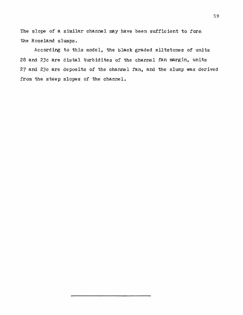
The slope of a similar channel may have been su f f i c i en t t o form
the Roseland slumps.
According t o t h i s model, the black graded s i l t s tones of uni t s
28 and 23c are d i s t a l tu rb id i tes of the channel fan margin, un i t s
27 and 23c a r e deposits of the channel fan, and the slump was derived
from the s teep slopes of the channel.

not exposed
not exposed 7
Figure 15 . Units 30 - 20 fac ies relat ions. Highly dia- gramatic. Section along s tr ike . See page for key t o unit numbers.

u n i t Thickness Exposed Descr ip t ion
22 3 a 7 (4.1) Gr'ey f i n e s i l t s t o n e and c lays tone with (4.2) good bedding. Thin s t r i n g e r s of coa r se r
s i l t s t o n e with r i p p l e bedding. Lower c o n t a c t sha rp b u t i r r e g u l a r .
(4.1 Southern s t r a t i g r a p h i c equ iva len t of 21a. Grey w e l l bedded s i l t s t o n e s with small s c a l e r i p p l e bedding, scour marks, very common. Dinosaur f oot-or i n t s very common (Anchisauriuus s p a ) one exposedv bedding ¥olai ( see P l a t e VII) has over 170 f o o t u r i n t s on a n a r e a of 120 f tVa2 . These beds a l t e r n a t e with t h i c k e r beds of f i n e s i l t s t o n e resembling u n i t 22.
21a l o - + 1 (4.2) Massive sandstone with large s c a l e c ross- bedding ( long i tud ina l ) . In t r a fo rmat iona l conglomerate a t base conta in ing b lebs of u n i t s 23c and 22. Upper p a r t of u n i t with r i p p l e beddine and r a r e small l e n s e s of very f i n e s i l t s t o n e with p l a n t remains. Fine beds pa lyni ferous .

4.7C Units 22-18a.
Unit 22.
The small g r a i n s i z e and l a c k of proofs of exposure
sugges ts suaqueous d e p o s i t i o n i n q u i e t water. A s varves do
n o t occur, it is probable t h a t u n i t 22 was deposi ted i n much
shal lower water t h a n the laminates .
Unite21a. 21b, and 20.
Unit 21a is a f ining-upwards cycle of the type
descr ibed i n s e c t i o n 4.4. Its l a t e r a l equiva lent , u n i t 21b,
is part of the same cycle . Unit 20 d i f f e r s from 21a and 21b
only i n c o l o r and occupies the middle and upper p a r t s of the
cycle . Figure 15 i n t e r p r e t s the l a t e r a l r e l a t i o n s h i p s of these
u n i t s . These u n i t a r e e s p e c i a l l y i n t e r e s t i n g s ince they
r e p r e s e n t the rees tabl i shment of f l u v i a l depos i t ion on the
shores of a receeding lake .
The massive, l a r g e s c a l e cross-bedded u n i t is bel ieved
t o r e p r e s e n t the base of the cycle : a poin t b a r depos i t . The
f i n e s i l t s t o n e l ense near the t o p of the u n i t is probably
a s t a rved channel f i l l , poss ib ly a former chute. The c o a r s e r
beds of u n i t 213 a r e c revasse s p l a y and n a t u r a l levee beds
of t h e channels of u n i t 21a. The l a c k of mudcracks and the
subordinate r o l e of c u r r e n t bedding i n the f i n e beds of u n i t
21b (resembling u n i t 22) sugges t depos i t ion i n q u i e t
l a c u s t r i n e water was the r u l e , w i t h s u b a e r i a l exposure the
rare exception. These u n i t were deposi ted on the f l u c t u a t i n g
shores of the waning lake.

Area Unit Thickness Exposed Descr ip t ion
(4.1) Northern beds with climbing r i p p l e s grading (4.2) upwards i n t o f i n e r i p p l e bedded s i l t s t o n e .
Southern exposures c o n s i s t of a l t e r n a t i n g l a y e r s of f i n e red s i l t s t o n e s and coarse gray s i l t s t o n e and minor sandstone. Color change from gray t o red upward.
/?:3 Red massive f i n e sandstones, s i l t s t o ~ e s , f i n e s i l t s t o n e s and minor c lays tones i n
3.3) t h r e e upward f i n i n g cycles . l a r g e s c a l e (4.1) cross-bedding i n coarse u n i t s and r i p p l e (4.2) bedding i n f i n e u n i t s . Base of some massive
u n i t s downcutting with l o n g i t u d i n a l grooves ( see p l a t e V I I I ) . Middle and upper p a r t s of upward f i n i n g cycles'with'numerous r o o t zones and dolomit ic concre t ions . ( see p l a t e I X ) . Dinosaur f o o t p r i n t s p resen t i n f i n e r beds. P l a n t impressions p resen t l o c a l l y . Common mud cracks i n upper park of cyc les .
(3 ,2 ) Red massive sandstone w i t h in t r a fo rmat iona l (3.3) s i l t s t o n e conglomerate a t base. Small and
s c a l e cross-bedding common, Large c a s t s of of t r e e limbs and rep t i l e?bones a t base.
Red s i l t s t o n e s a n d claystone a l t e r n a t i n g w i t h brown and red sandstone and - coarse s i l t s t o n e . Small s c a l e cross-bedding common i n f i n e u n i t s and upward-f in ing common i n t h i n sandstones. Mean sandstone bed th ickness l e s s t h a n .5 f o o t . Rep t i l e f o o t p r i n t s exceedingly common. Rare bone fragments, impress ions of p l a n t s (mostly c o n i f e r s ) r i p p l e marks, and r a r e mud cracks.
18a 1.5 (3.2) Red c lays tone and s i l t s t o n e w i t h r i p p l e bedding and r a r e mud cracks. Numerous r e p t i l e f o o t p r i n t s . P lan t fragments as impress ions present .

Unit 20 i l l u s t r a t e s the r e l a t i o n s h i p between sediment
p o r o s i t y and r e d bed formation. The nor thern exposures of the
u n i t a r e n a t u r a l levee d e p o s i t s grading upward i n t o f lood
p l a i n beds (upper p a r t of f i n i n g upward cycle ). The southern
exposures a r e t h e f i n e r beds of the f lood bas in , a l t e r n a t i n g
with the coa r se r beds of crevasse splay.
The sandy beds were undoubtably more porous s h o r t l y
a f t e r depos i t ion than the f i n e s i l t s tones . The c o l o r d i s t r i b -
u n t i o n of u n i t 20 can be explained by assuming t h a t r educ t ion
of the non-red beds occured as the. d e t r i t i a l g o e t h i t e was
exposed t o the ppool*' of s u l f i d e r i c h , interstitial waters of the
hypolimnion of the previous ly e x i s t i n g meromictic lake1? Units
22, 21a, 21b, and 20 a r e t r a n s i t i o n a l between l a c u s t r i n e and
f l u v i a l depos i t s . The frequency of submergence of u n i t 20 a f t e r
its depos i t ion was s u f f i c i e n t l y g r e a t t o reduce the g o e t h i t e i n
the permeable, coarse sediments bu t i n s u f f i c i e n t t o reduce a l l of
the g o e t h i t e i n the silts and c l a y s of th6 f i n e beds. Enough
goethite remained i n these beds t o age t o hemati te and c o l o r
them red .
Units 19, 18a, and 18b. P l a t e s VIII, IX, X
Unit 1 9 is a s e r i e s of t h r e e upward f i n i n g c y c l e s of
t h e type descr ibed i n s e c t i o n 4.4. This is a very heterogeneous
u n i t which should be subdivided a f t e r f u r t h e r mapping. Units
' ~ e r n e r (1971 ) no tes t h a t amounts of HnS a r e no t the l i m i t i n g f a c t o r i n p y r i t e production. There is always a n excess of sulf ide. The s u l f i d e concent ra t ion i n c r e a s e s through the l i f e of a meromictic lake with closed c i r c u l a t i o n . T h i s may remain a f t e r the d e s t r u c t i o n of the lake as a *'pool1* of a v a i l a b l e s u l f i d e s i n ground water.

l 8 c , 18b, and 18a form a n upward f i n i n g cycle of t h e same type.
The lower d i v i s i o n of t h e cyc les c o n s i s t s of massive c r o s s
bedded sandstone with a b a s a l i n t r a f o rna t iona l conglomerate :
a po in t bar depos i t . I n t h e middle d i v i s i o n beds of f i n e
s i l t s t o n e a l t e r n a t e w i t h coa r se r beds i n a t y p i c a l bank
depos i t . I n u n i t 1 9 the upper d i v i s o n is a f lood b a s i n
u n i t with abundant evidence of d e s i c c a t i o n . Evidence of
d e s i c c a t i o n is not p resen t i n u n i t l8a.
R e p t i l e f o o t p r i n t s a r e very common i n t h e upper
two d i v i s i o n s of t h e fining-upwards cyc les , e s p e c i a l l y i n
u n i t l8b. Foo tp r in t s of t h e h i g h e s t q u a l i t y a r e found i n
t h e middle d iv is ion ,wi th ve ry shallow f o o t p r i n t s i n the
upper d i v i s i o n . The f i n e s t f o o t p r i n t s (natural c a s t s ,
s ee p l a t e X ) occur i n beds where crevasse s p l a y d e p o s i t s
a l t e r n a t e with f lood b a s i n sediments. .
The crevasse s p l a y beds of the middle d i v i s i o n of
upward f i n i n g c y c l e s show a s e r i e s of c y c l i c sedimentary
s t r u c t u r e s . These cyc les resemble modern crevasse s p l a y
of t h e Brahmaputra River descr ibed by Coleman (1969)~ A
sandy sequence with r i p p l e bedding a few cent imeters t o a
few decimeters t h i c k is topped by a f i n e s i l t s t o n e l aye r .
( see figure 1 2 ) . R e p t i l e f o o t p r i n t s may occur as s o l e marks
on t h e lower su r face o r as impressions on t h e upper su r face .
Unit l 8 c is a t y p i c a l lower d i v i s i o n :of a f i n i n g -
upwards cycle. The lowes t p o r t i o n con ta ins a n in t ra fo rmat iona l
conglomerate and l a r g e s i l t s t o n e c a s t s of t r e e l imbs and a
poss ib le ' large r e p t i l e jaw ( ~ r , Donald B a i r d , Pers. Corn.).
Unit 18b h a s very w e l l developed crevasse s p l a y and natural

Area Unit Thickness Exposed Description
Red grading up in to grey-green f ine s i l t s tone . Rare mudcracks, ripple-bedding, r e p t i l e footpr ints r a re plant fragments preserved as impressions and carbonized compressions.

levees . The f i n e s t dinosaur f o o t p r i n t s i n the Roseland Quarry
come from t h i s u n i t . R e p t i l e t e e t h have been found i n the
lower p a r t s of the crevasse sp lay beds as wel l . On the
whole, the fauna of u n i t s 18c-18a is more d ive r se .and p l e n t i f u l
than proceeding upward f i n i n g cyc les .
Unit 17.
This is the uppermost p a r t of the previously descr ibed
upward f i n i n g cycle . The sedimentary s t r u c t u r e s of these
beds i n d i c a t e t h a t the environment of depos i t ion was s t i l l
f l u v i a l ( f lood b a s i n ) . The c o l o r change i n r e l a t i o n t o the
p rese rva t ion of p l a n t s i n t h i s u n i t deserves s p e c i a l no t i ce .
P lan t remains, i n the form of fragmented d e b r i s ,
t w i g s , l eaves , and branches, a r e common i n most Roseland
sedimentary u n i t s . These occur as impressions along bedding
p l a i n s , and s i l t s t o n e c a s t s i n r e d beds and as carbonized
compressions i n non-red beds . The occurrence of carbonized
p l a n t remains surrounded by g reen ha los can be explained
by the fol lowing hypothesis .
I n most r ed beds i n the Roseland Quarry, the organic
mat ter of p l a n t remains must have been removed by r o t t i n g
and leaching a f t e r depos i t ion . T h i s took. place i n a n
ae rob ic environment s o t h a t s u l f u r conta in ing organics
were oxidized t o s u l f a t e s and washed out of the sediments.
S h o r t l y a f t e r the d e p o s i t i o n of u n i t 17, however, t h e mero-
mic t i c lake of member A (see s e c t i o n 4.7D) began t o develop
and s u l f i d e conta in ing waters of t h e hypolimnion began t o
s a t u r a t e the sediments. The enclosed p l a n t remains of u n i t

1 7 added s u f f i c i e n t s u l f ide l o c a l l y , t h a t , when added t o the
hypolimnic s u l f i d e s , the concen t ra t ion was s u f f i c i e n t t o
reduce the zone d i r e c t l y around the p l a n t s b u t i n s u f f i c i e n t
t o s t o p g o e t h i t e ag ing i n the bulk of the sediments a t the
same horizon. S h o r t l y t h e r e a f t e r , the hypolimnic waters
became s u f f i c i e n t l y s u l f i d e r i c h t o reduce the u n i t s above
4. ?D Summary of Units 31-17.
Member B of the Towaco Formation is represented by
u n i t s 30-17 i n t h e Roseland Quarry. B r i e f l y r e s t a t e d , these
beds record the formation and d e s t r u c t i o n of a deep 2 meromictic lake covering a minimum of 920 km. (360 m i . ).
F l u v i a l condi t ions followed l a c u s t r i n e . Deposi t ion of a
varved lamini te , t u r b i d i t e s and slumps occured dur ing
h i g h e s t the h i g h e s t lake l e v e l s , while meandering s t reams
and r i v e r s produced upward f i n i n g cyc les during t h e
f l u v i a l s t age .
4.7E Member A of the Towaco Formation: Units 17-5,
The upper p a r t of u n i t I? is t h e base of ano the r
Towaco cycle (member A ) . The exposures of member A i n t h e
Roseland Quarry a r e more t y p i c a l of Towaco cyc les t h a n
member B e The main d i f ferences between u n i t s 30-17 and
and u n i t s 17-5 a r e t h e l a c k of slump beds i n t h e
l amin i t e u n i t . o f member A and t h e absence of ano the r
Towaco cycle above member A .

Area Unit Thickness Exposed Descr ip t ion
16 6.3 (3.2) Gray f i n e sandstones and s i l t s t o n e s i n f i n i n g upwards sequence. I r r e g u l a r c a l c i u m carbonate nodules which weather ou t t o form l i m o n i t i c c a v i t e s . Unit r i p p l e bedded with r a r e small mud cracks. r i p p l e marks, and common dinosaur f o o t p r i n t s . C ornmon l a rge carbonized p l a n t stems and t r e e branches.
2 (3.2) Green-gray f r i a b l e f i n e s i l t s t o n e . Very poorly exposed.
1 (3.2) Very s o f t g ray c layey s i l t s t o n e . -Black laminae i n upper p a r t . Gradat ional with u n i t 13. Extremely poor exposure.
.8 (3.2) Black l amic i t e . Black saprope l - r i c h and ~ h i t e - calcium carbonate coup le t s .42 mrn. t h i ck . Upper p a r t of u n i t has s e v e r a l 5 mm. t h i c k graded b lack s i l t s t o n e l a y e r s * Grades i n t o u n i t 12. Very poorly exposed*

4.7E Units 16 - 5 - Member A
Units 16-14.
These un i t s record much the same sequence of environ-
ments of deposition as un i t s 30 and 29. Unit 16 is a small
f in ing upwards cycle, the in te rna l s t ructure of which,
resembles the na tura l levees of the Bramaputra River
(Coleman, 1969) r a the r than a f u l l y developed meandering
channel cycle. There a r e numerous calcium carbonate nodules
which could be r e s u l t of a- rapidly f luctuat ing water table.
The middle portion of these beds contain numerous dinosaur
footpr ints (see p la te X I ) .
Units 15 and 14 a r e interpreted as t r ans i t iona l
lacustr ine sediments resembling un i t 29. Apparently, un i t s
16-14 a r e the shore deposits of a transgressing lake.
Unit 13.
The varved laminite of member A (uni t 13) is very
similar t o uni t s 28 and 23c and deposition i n a meromictic
lake seems l ikely. The black graded beds appearing near
the top of the un i t a r e interpreted as d i s t a l tu rb id i tes .
The recumbent fo lds i n the upper pa r t of t h i s un i t
must have been formed when the beds were s t i l l p las t i c and
may have something t o due with the diagene.sis 6f the
overlying uni ts .
The varves of un i t 13 a re very obvious and thin ,
Varve counts indicate deposition a t the r a t e of -42 nun./ yr.
T h i s lake, l i k e t h a t of member B must have covered a minimum
of 920 kmO2 (360 miO2).

Area Unit Thickness Exposed Descr ip t ion
1 .2 (3.2) Black, completely s l i c k e n s i d e d c layey s i l t s t o n e with numerous f l i n t nodules. Poor exposure.
Grey f i n e e l a s t i c s . Some graded bedding. Rare impressions of gypsum c r y s t a l s on bedding p lanes .
Very dark g r e y massive c l a y c lays tone with b lack laminae. Lower c o n t a c t smooth and non-gradational. C onchoidal f r a c t u r e with no p a r t i n g planes. Good p l a n t fragments including 3rachyphyllum twigs and cones, Semionotus s c a l e s , and '
i n s e c t s .
Grey massive claystone with da rk laminae similar t o u n i t . 10. Semionotus s c a l e s absen t . Lower c o n t a c t sha rp b u t without p a r t i n g p lanes .

Area Unit Thickness Exposed Descr ip t ion
Black, completely s l i c k e n s i d e d c layey s i l t s t o n e with numerous f l i n t nodules. Poor exposure.
Grey f i n e e l a s t i c s . Some graded bedding. Rare impressions of gypsum c r y s t a l s on bedding p lanes .
Very dark g r e y massive c l a y c lays tone with b lack laminae. Lower c o n t a c t smooth and non-gradational. C onchoidal f r a c t u r e with no p a r t i n g planes. Good p l a n t fragments including 3rachyphyllum twigs and cones, Semionotus s c a l e s , and '
i n s e c t s .
Grey massive claystone with dark laminae similar t o u n i t . 10. Semionotus s c a l e s absen t . Lower c o n t a c t sharp b u t without p a r t i n g p lanes .

Unit 12.
The meromictic lake seems t o have s t i l l been i n
existence during the deposition of uni t 12. A similar g ra in
s i ze and remnant varves indicate a similar r a t e of deposition
t o un i t 13 . Deposition of uni t s 1 2 and 13, therefore, took a
a minimum of 1380 years: a n indication of the minimum l i f e
of the s t r a t i f i e d lake . An or ig in f o r the f l i n t nodules is d i f f i c u l t t o f ind.
They may be replacing limestone, but since no limestone is
present, t h i s is uncertain. The nodules must have been present
before dewatering of the beds since the deformation of t h i s
un i t has not effected s t r a t i f i c a t i o n present i n the f l i n t .
It seems probable t h a t deformation o f the un i t is p a r t i a l l y
the r e s u l t of d i f f e r e n t i a l compaction d u r i n g dewatering and
a small th rus t f a u l t through the unit .
Unit 11.
The lack of recent exposure precludes a detai led in te r -
pretat ion. What information is known is consistant w i t h
deposition by suspension and tubid i ty currents i n a shrinking
lake. Occasional gypsum c rys ta l s a re evidence of increasing
solute concentration i n the l a t e stages of the lake.
Units 10 and 9 .
These a r e in t e rp re ted as a shallow water lake deposit.
The lack of current bedding and part ing plains indicates
a very protected environment.

Unit Thickness Exposed Descr ip t ion
8 3 .6 ( 3 , 3 ) Gray-light green, f i n e s i l t s t o n e , massive, i n d i s t i n c t l y bedded, with sedimentary d ikes . Carbonized p l a n t remains common. Minor s i l t s t o n e l a y e r s with poss ib le r e p t i l e f o o t p r i n t s .
+5 (3,1) Massive g r a y sandstone and coarse (3.2) s i l t s t o n e grading upward i n t o brown (3 ,3) s i l t s tones . Lower p a r t massive with
l a r g e s c a l e cross-bedding, c u r r e n t l inea t ion , r i b and furrow s t r u c t u r e s , r i p p l e marks and a minor i n t r a f ormational conglomerate a t base. Upper c o n t a c t g r a d a t i o n a l and lower con tac t sha rp and c r o s s c u t t i n g a g a i n s t u n i t 8 . Carbonized p l a n t remains common.
?6 ( 3 , 2 ) Gray-buff -lavender-brown silts t one, (formerly) nowhere exposed : known from quar r i ed
blocks.
( 3 2 ) Buff s i l t s t o n e i n a maroon matrix: a n i n t r a f ormational conglomerate.
5 successive f ining-upward^ c y c l e s of r ed cross-bedded sandstones grading up i n t o r ed s i l t s t o n e s . Lower massive por t ions have l a r g e s c a l e cross-bedding, climbing r i p p l e s , graded beds, in t r a fo rmat iona l conglomerates, and c u r r e n t l i n e a t i o n . Upper d i v i s i o n s cha ra te r i sed by small s c a l e cross-bedding , a l t e r n a t i n g beds of p e r s i s t a n t 1-10 cm. beds of coarse s i t e t o n e s with samall s c a l e cross-bedding . Three middle fining-upwards c y c l e s , with

7 4
Unit 8.
The l i t h o l o g y of u n i t 8 is ind ica t ive of the same kind
of d e p o s i t i o n a l environment t h a t produced u n i t s 22 and 21b:
t r a n s i t i o n a l f luvio- lacus t r ine beds deposited i n the q u i e t
shallows a long the margins of the shr inking lake.
Units 7 and 6.
These unite comprise a fining-upwards cycle n e a r l y
i d e n t i c a l t o u n i t s 21a and 20. F l u v i a l depos i t ion by
meandering r i v e r s and streams near t h e shore of the
dwindling lake is probable. The t r a n s i t i o n from red t o g r e y
i n u n i t appears t o be very similar t o u n i t 20 b u t poor
exposure precludes a f i n e r i n t e r p r e t a t i o n .
Units 5a and 5.
The f ining-upwards cyc les of t h i s u n i t i n d i c a t e
depos i t ion under condi t ions , more or l e s s , similar t o
those respons ib le f o r u n i t 19. Unit 5a is t h e base of the
lowest fining-upwards cycle . It con ta ins d e b r i s of u n i t s 8
and 6 i n d i c a t i n g a c t i v e e r o s i o n of those u n i t s . The upper
d i v i s i o n of the lowest cyc le con ta ins f i n e r ed s i l t s t o n e s
with r a r e c o p r o l i t e s conta in ing f i s h s c a l e s (~emiono tus sp. )
and worm burrows ( see p l a t e XII,).
The upper d i v i s i o n s of t h e middle three fining-upwards
c y c l e s of u n i t 5 c o n t a i n i n d i c a t i o n s of r a t h e r severe
des icca t ion . These beds a r e s i n g u l a r l y devoid of good
r e p t i l e f o o t p r i n t s . The h i g h e s t f ining-upwards cyc le ,
on t h e o the r hand,, has numerous c a s t s and impressions of

Area Unit Thickness Exposed
Hook Mountain
flow 1 50
flow 2 10+
Descr ip t ion
Deep r e d , hard s i l t s t o n e grading i n t o above and below. Well bedded with small s c a l e r i p p l e bedding, mud cracks common. Poss ib le r e p t i l e f o o t p r i n t s .
Dark lavender and maroon s i l t s t o n e w i t h the small orange c r y s t a l s (badly weatherd ) common along v e r t i c a l p lanes . Small s c a l e cross-bedding common.
Light g r a y and lavender tuf faceous s i l s t o n e , l o c a l l y laminated with small s c a l e cross-bedding . Same c r y s t a l s as u n i t 3 . Light brown or b u f f , badly weathered, poorly bedded t u f f with l i g h t shards. Spheroidal e x f o l i a t i o n l o c a l l y . Contact with b a s a l t sha rp and i r r e g u l a r on a small s c a l e .
T h e o l e i i t i c b a s a l t . Massive a t base, columnar jointed i n middle, ves i c u l a r a t the top.
Highly v e s i c u l a r and pillowed. Lower c o n t a c t very i r r e g u l a r .

of c o n i f e r s and a r t i c u l a t e s , twigs and branches. It may
be important t o note t h a t bed% a t the same s t r a t i g r a p h i c
pos i t ion , 2 miles t o the nor th , c o n t a i n a bed of r e d and
g ree mottled s i l t s t o n e w i t h numerous carbonized p l a n t
fragments, f i s h s c a l e s and c o p r o l i t e s .
4 . 7 ~ Summary of u n i t s 17-5.
The sequence of d e p o s i t i o n a l environments of u n i t s
17-5 and 30-l8a, as i n t e r p r e t e d here, have much i n common.
A l a r g e deep meromictic lake developed, waxed, waned, and
and f i n : a l l y was replaced by a f l u v i a l environment. There
is some i n d i c a t i o n of d e s i c c a t i o n i n the middle of u n i t
19 and a r e t u r n t o moister condi t ions near the t o p of u n i t
5 (see figure 8 ) . 4.7F The End of Towaco Deposition.
Units 4-1 incorporate increas ing amounts of tuf faceous
m a t e r i a l upward. There is a l s o a n inc rase i n the degree
thermal metamorphism due t o the e f f e c t s of the Hook Mountain
Basalt. Units 4, 3 , and 2 a r e water deposi ted i n a f l u v i a l
environment, while u n i t 1 may be a n a i r born t u f f . S imi lar
u n i t s have been descr ibed interbedded i n the Orange Mountain
jasalt, and Hampden basalt by Van Houten (1969) and Sanders
(1963).

5. THE LARGER PICTUREiDISCUSSION.
5.1 D e p o s i t i o n a l Environment .
A c o n c l u s i o n from t h e i n t e r p r e t a t i o n o f t h e Rose l and
Q u a r r y s e c t i o n , applicable t o a l l o f Towaco s e d i m e n t a t i o n ,
i s t h a t members A and B o f t h e Towaco Forma t ion record
t w o e p i s o d e s of meromictic l a k e deve lopmen t a n d demise .
Exposu res o f Towaco members C, D , E , a n d F are, more or less,
s i m i l a r t o members A a n d B and p r o b a b l y r e f l e c t t h e same series
o f d e p o s i t i o n a l e n v i r o n m e n t s . S p e c i f i c e n v i r o n m e n t a l r e c o n s t -
r u c t i o n of o t h e r u n i t s must be b a s e d on t h e de ta i led s t u d y o f t h e i r
l i t h o l o g y a n d f a c i e s r e l a t i o n s .
The non-red p o r t i o n s o f Tobaco c y c l e s a n d t h e a d j o i n i n g
f l u v i a l , upward f i n i n g c y c l e s c o n t a i n a r i c h and v a r i e d f i s h
and r ep t i l e f a u n a and a diverse f l o r a ( O l s e n , M.S., C o r n e t , M.S.).
T h i s s p e a k s f o r a r e l a t i v e l y h o s p i t a b l e climate d u r i n g t h e
d e p o s i t i o n o f t h e s e beds. On t h e o t h e r hand, c e r t a i n upward
f i n i n g c y c l e s i n t h e middle p o r t i o n s o f t h e r e d u n i t s o f
Towaco c y c l e s may h a v e been d e p o s i t e d u n d e r more a r i d c o n d i t i o n s .
A model o f c a l i b r a t i o n o f t h e Towaco Forma t ion is p r e s e n t e d i n
s e c t i o n 5.3 which s u g g e s t s climatic c o n t r o l of t h e
Towaco c y c l e s . T h i s model i n v o l v e s climatic f l u c t u a t i o n s t h r o u g h
a l l o f Towaco d e p o s i t i o n , so climatic g e n e r a l i t i e s are, a t t h i s
p o i n t , p r e m a t u r e .
5.2 Mone on Red Beds.
The s i g n i f i c a n c e o f color for e n v i r o n m e n t a l i n t e r p r e t a t i o n


Lockatong c y c l e t o t h e p r e c e s s i o n c y c l e of 21,000 y e a r s .
What is t h e r e l a t i o n s h i p of a Towaco c y c l e t o a ~ o c k a t o n g
c y c l e and what r e l a t i o n s h i p , i f any, i s t h e r e t o t h e p r e c e s s i o n
c y c l e ?
Both Lockatong and Towaco cycles r e s u l t from the same
cyc l i c phenomena: waxings and waningsof large lakes. A
c a l i b r a t i o n of the durat ion of a Towaco lacus t r ine f l u v i a l
cycle depends on inferring the r a t e s of sedimentation, which
is a n o t o r h s l y speculative' process. Van Houten (1969)
found t h a t by extrapola t ing the r a t e s of deposi t ion over the
e n t i r e Lockatong cycle the t o t a l dura t ion of the
cycle was a mean of 21,000 yrs. T h i s was reasonable because
the g r a i n s i z e of the: cycles is very f i ne . Towaco cycle
sediments vary from very f i n e t o very coarse and it would
be i l l o g i c a l t o ext rapola te varve sedimentation r a t e s over
the whole cycle.
Anderson (1964) defines seven orders of stratif ic- .
a t i o n on the basis of varve ca l ib ra t i on . (see f i gu re 1 6 ) .
Cyclic u n i t s of the Towaco Formation can be r e l a t e d t o
s eve ra l of h i s orders of s t r a t i f i c a t i o n . F i r s t order cycles
a r e present as varves i n the laminites . If the assumption
is made t h a t the f in ing upward f l u v i a l cycles correspond
t o h i s 4 th order cycles (1000-3000+ yrs: low energy bedding
and h igh energy scour bedding), it is possible t o at tempt t o
c a l i b r a t e the Towaco cycles.
A ca l cu l a t i on of the durat ion of Towaco cycles r e s t s
on the following assumptions 8
1. extrapola t ion of varve counts t o other f i n e grained beds is va l id

2. the depos i t ion of the slump beds of u n i t s 26-24 involved a n i n s i g n i f i c a n t amount of time.
3. fining-upward cyc les correspond t o a mean d u r a t i o n of 2000 years .
The fol lowing is used t o c a l c u l a t e the dura t ion of a Towaco
Formation ( a l l d a t a from Table 111).
Table V
th ickness yea r s
Member B e - number of varves / cm. = 25
th ickness of l amin i t e s ( u n i t s 28+23c) th ickness of o ther f i n e s
6 upward f i n i n g c y c l e s t o t a l dura t ion of member B
Member A . - number of varves / cm. = 23
t h i c kne ss of l amin i t e s
th ickness of o ther f i n e s 7 upward f i n i n g cyc les t o a t a l dura t ion of member A
75 cm. 1875 186 cm. 4650
12000
18525
60 cm. 1380
360 cm. 8280 14000 23660
Mean d u r a t i o n Towaco cycle a t Roseland 21095 yrs.
It is r e a l i z e d t h a t t h i s is a n exe rc i se i n e x t r a p o l a t i o n
and t h a t t h e s ign i f i cance of t h e r e s u l t s is l imi ted by
t h e assumptions (which a r e tenous) . Nevertheless, t h i s may
be used as a working hypothesis : t h e d u r a t i o n of a Towaco -.
cyc le may have been i n the order of 21,000 years .
Van Houten (1969) a s c r i b e s the 21,000 yr. p e r i o d i c i t y
of t h e Lockatong Formation t o c l i m a t i c c o n t r o l based on the
precession cyc le . Since both' t he mode of o r i g i n and t h e
r e l a t i v e d u r a t i o n of the two cyc le types seem t o be the

same, it is tempting t o i n f e r c l i m a t i c c o n t r o l of Towaco
cyc les . Assuming t h i s t o be t r u e , the l a c u s t r i n e p o r t i o n of
a Towaco cyc le developed i n a moist c l imate , while the
f l u v i a l p a r t was deposi ted dur ing a more a r i d c l imate . It
is i n t e r e s t i n g t o note (see f i g u r e 8 , sec t ion 4 . 6 ~ ) t h e e v i -
dence of most severe desiccat ion occurs near the middle of
the r ed bed sequences i n t h e Roseland Quarry, e x a c t l y
where they would be expected by t h i s model.
If the Towaco c y c l e s a r e based on the precess ion ,
cyc le , the mean sedimentat ion r a t e f o r the Towaco Formation
is about 1.4 m m . / y r . and t h e whole formation was deposi ted
i n about 250,000 yrs. This is a n order of magnitude f a s t e r
than Van ~ o u t e n k es t imate of Lockatong sedimentat ion r a t e s
( .215 mm. /y r . ) b u t w i t h i n the r a t e s of f lysch and Mollasse
sedimentat ion (Fisher , 1969).
5.4 Basin Rates of Subsidence and R i f t i n g of the North A t l a n t i c
Some impl ica t ions of the mode of Towaco cyc le
depos i t ion include b a s i n and p l a t e t e c t o n i c s . The i n f e r r e d
r a t e s of depos i t ion suggest a n increased r a t e of b a s i n
subsidence compared t o t h a t during Lockatong depos i t ion .
A l l known volcanics of the Newark Supergroup seem t o
have been implaced or extruded dur ing a r e l a t i v e l y s h o r t
period of volcanism (De Boer, 1968; F a i l l e , 1973 ) . A l l of t h e
sedimentary u n i t s interbedded between lava flows which have
been dated by contained palynomorphs and faunules a r e of
lower L iass i c age, confirming a r e s t r i c t e d period of
vulcanism .

If it is assumed t h a t the depos i t ion of the Towaco
Formation was i n equi l ibr ium w i t h b a s i n subsidence, t h e
implied r a t e is more than six t imes Van Houterfs e s t ima te f o r
t h e Lockatong Formation (1.4 m m , / y r . compared t o .215mm./yr).
Cycles similar i n morphology and s c a l e t o Towaco c y c l e s
occur i n t h e F e l t v i l l e Formation of the Novacaesarea Group,
the upper h a l f of the Culpeper Group (between lava flows , Olsen, pers . obs. ), and the S h u t t l e Meadow Formation and
E a s t .Berlin Formation. S imi la r r a t e s of b a s i n subsidence
and depos i t ion a r e i n f e r r e d f o r these u n i t s and the Towaco
Formation.
F a i l l e (1973) provides evidence t h a t t h e Newark and
Gettysburg 3 a s i n s may have been simple downwarps during
depos i t ion of the Newark Supergroup. Sanders, on t h e o ther
hand, s u p p l i e s equa l ly good evidence t h a t t h e Newark and
Hartford 3as i n s were deposi ted i n down-faulted grabens.
It must be pointed out t h a t a s of F a i l l e ' s argument is
based on the morphology of the lower h a l f of the Novacae-
s a r e a Group and the Conewago Group both of which a r e Upper
T r i a s s i c i n age. Sanders* evidence is based on the beds of
t h e Upper Novacaesarea Group (Passa ic s y n c l i n e ) and the
upper Hartford Group, both of which a r e lower Jurass ic!
Both resea rcher s may be c o r r e c t i n t h e i r r e spec t ive a r e a s .
Basin subsidence during the depos i t ion of the lower
Novacaesarea Group seems t o have been much l e s s t h a n t h a t of
the upper p a r t of the Kovacaesarea Group, upper Hartford
Group, and upper Culpeper Group. The low r a t e of subsidence
of the lower Newark Supergroup is assoc ia ted with a downwarp
b a s i n morphology, the complete l ack of contemporaneous

volcanics , and a n Upper T r i a s s i c age. Contrarywise , t he
upper Newark Supergroup, with i ts high r a t e of b a s i n sub-
s idence , is a s s o c i a t e d with graben s t r u c t u r e s , ex t rus ive
and i n t r u s i v e volcanics , and a Lower J u r a s s i c age. I
sugges t t h a t many Newark Basins o r ig ina ted as downwarps
dur ing the late,Middle T r i a s s i c or ear ly , Late T r i a s s i c
and it was not u n t i l t he Ear ly J u r a s s i c t h a t graben s t r u c -
t u r e s were super imposed.
It may be very s i g n i f i c a n t t h a t the e a r l i e s t known
Mesozoic marine beds of the c o n t i n e n t a l she lves of e a s t e r n
North America and West Af r i ca a r e Ear ly J u r a s s i c l imestones,
evapor i t e s , and e l a s t i c s overlapping red beds of Newark
Supergroup l i t h o l o g y (Amoco Ltd. and Imperial O i l Ltd ., 1974 ). The e a r l i e s t known marine beds of the A t l a n t i c a r e , t h e r e f ore ,
contemporaneous with the upper Newark Supergroup of the
Eas te rn Piedmont. It is t h e r e f ore probable, t h a t the bas ins
of the rift zone between the North American and Af r i can
p l a t e s d id no t open t o marine waters u n t i l t he Ear ly J u r a s s i c .

6 BIBLIOGRAPHY
Allen, J.R.L. 1964. Studied i n f l u v i t i l e sedimentation: s i x cyclothems from the lower Old Red Sandstone, Anglo-Welsh Basin. Sedimentolosy, 3, 163-1 98. 1965a. The sedimentat ion and paleogeography of the Old Red Sandstone of Anglesey, North Wales, Proc. Yorks. Geol. polytech. SOC., 35, 1939-85. 1965b. A review of t h e o r i g i n and c h a r a c t e r i s t i c s of r e c e n t a l l u v i a l sediemnts. Sedimentology, 5, 89-191 1969. Phys ica l Processes of Sedimentation. American E l s e v i e r Pub. Co., N.Y.
1970. S tud ies i n f l u v i t i l e sedimentation: a comparison of f ining-upwards cyclothems with s p e c i a l r e fe rence t o coarse member composition and i n t e r p r e t a t i o n . J. Sed. Pet. , 40, 298-323.
Amoco Ca. Ltd. and Imperial O i l L t d , , Staff . 1974. Regional geology of Grand Banks. Am. Assoc. Pe t . Geol. 3 ~ 1 1 . ~ 58, 6 , p t * I1 of 11, ~1109-1123.
Anderson, R . Y . 1964. Varve C a l i b r a t i o n of S t r a t i f i c a t i o n . Syncosium on Cyclic Sedimentation. Bull . S t a t e Geol. Survey Kansas, Univ. Kansas, 169, vol . 1.
Anderson, R . Y . and Kirkland, D.W. 1960. Origin, v a n e s , and c y c l e s of J u r a s s i c Tod i l to Formation, New Mexico. Am. Assoc. Pe t . Geol. a u l l . , 44, p37-52. 1966. In t ra -bas in varve c o r r e l a t i o n . G.S.A. !3ull. 77, ~241-255 1,969. Paleoecology of a n Ear ly P l e i s t o c c ~ e Lake on the High P l a i n s of Texas. G.S.A. Memoir 113.
Ballard, R.D. and Uchupi, E. 1974. Carboniferous and T r i a s s i c r i f t i n g : a pre l iminary o u t l i n e of the t e c t o n i c h i s t o r y of the Gulf of I/iaine. G.S.A. Aull . , 83, ~2285-23 01 .
Bain, G .W. 1932. Northern a r e a of Connecticut Val ley T r i a s s i c . AaJeS-, 23, ~ 5 7 - 7 7 .
3aird, D. and Take, W.F. 1959. T r i a s s i c r e p t i l e s from Nova Sco t i a ( a b s t ) . G.s.A. ~ u l l . 70, ~1565-1566.
b a r r e l , . J. 1908. Re la t ion between c l imate and t e r r e s t r i a l de o s i t s . Jour. Geol. 16, 159-190, 255-295, 363- 3 8 t .
Berner , R .A . 1970. Low temperature geochemistry of i r o n ; I n Handbook of Geochemjstry, v. 11-1, s e c t i o n 26. - s p r i n g e r - ~ e r l a g , Ber l in .

1971. P r i n c i p l e s of Chemical Sedimentoloev, McGraw-Hill, N. Y .
Bouma, A.H. 1962. Sediment01 of some f lysche depos i t s . 168pp. E l s e v i e r , A2;erdam.
1964. Ancient and r e c e n t t u r b i d i t e s . Geol. Mijnbouw, 43e, 375-379.
douma, A.H. and Broumer, A. eds . 1964. Turbid i tes . Dev. i n Sedimentology . , 3, 2 6 4 ~ ~ .
Bradley, W.H. 1929. The varves and c l imate of the Green River epoch. U.S.G.S. Prof . Papers, 1584, p87-110.
3 ramle t t e , M. N. 1946. The Montrey Formation of C a l i f o r n i a and the o r i g i n of i ts s i l i c e o u s rocks. U.S.G.S. Prof. Papers, 212, 57pp.
drown, C . 3 . 1932. A new T r i a s s i c a r e a i n North Carolina. A.J.S. 5 t h s e r i e s , 23, 525-528.
Coleman, J . M . 1969. 3rahrnaputra River , Channel processes and sediemntation. Sed. Geol., 3 , 129-239.
Cornet, B., Traverse, A * , and McDonald, N.G. 1973. F o s s i l spores , pol len , and f i s h e s from Connecticut
ind ica te Ear ly J u r a s s i c age f o r p a r t of the Newark Group. Science, 182, 1243-1247.
Crampton, C .B., Carruthers , R . G . , Horne, J., Peach, i 3 . N . , F l e t t , Jose, and Anderson, E.M., 1914. The geology of Cai thness . Geol. Surv. G t . d r i t . Mem. Geol. Surv. Scot. , 194pp.
Darton, N.H. 1889. On the g r e a t lava flows and i n t r u s i v e t r a p s h e e t s of the Newark System i n New Jersey . A.J.S., 3rd s e r i e s , 38, 134-139.
Davies, G.R. and Ludlam, S.D. 1973. Origin of laminated and graded sediG@nts, Middle Devonian of Western Canada. G.S.A. .Bull., 84, 3527-3546.
De Geer, G . 1912. A chronology of the last 12000 years . Cone. G(501. I n t e r . Compt. Rend. l i e , Stockholm, 191 0, pp24l-253 .
De Boer, J. 1968. Paleomagnetic d i f f e r e n t i a t i o n and cor- r e l a t i o n of the Late T r i a s s i c volcanic rocks i n the c e n t r a l Appakhians (with s p e c i a l r e fe rence t o the Connecticut v a l l e y ) : G.S.A. 3 u l l . 79, 609- 626.
Duff, P ~~IcL., H a l l a m , A * , and Walton, E.K. 1967. Cycl ic Sedimentation. Developments i n Sed irnentology, 10, E l s e v i e r , Amsterdam.

Dzulynski, S. and Walton, E.K. 1965. Sedimentary Features of Flysch and Gre-ywackes. E l sev ie r , Amsterdam,. 274pp.
Emery, K.O. and Uchupi, E. 1972. Western North A t l a n t i c Ocean. Am. Assoc. Pe t . Geol., Memoir 17, 532pp.
Emmons, E. 1857. Permian and T r i a s s i c systems of N . C . ( a b s t ) . Edin. N. Ph. J.2. 5, 370.
F a i l l e , R .T . 1973. Tectonic development of the T r i a s s i c Newark- Ge t tysburg 3 a s i n i n Pennsylvania. G . S . A . 3 u l l . 84, 3 , 725-740.
Geyer, A.R. 1956. Geology of Lebanon Quadrangle. Pa. G S , 4 t h s e r . , Geol. Atlas l 6 7 ~ , 1956.
1963. Geology and mineral resources of the Womelsdorf Quadrangle. Pa. G . S. 4 t h s e r . , Bul l . A 1 7 7 C , 1963.
Glaeser , J . D . 1963. L i t h o s t r a t i g r a p h i c Nomenclature 'of the Triassic Newark-Gettysburg Basin. Penn. Acad Sc i . Proc. 37, 179-188.
1965. Sedimentary d i s p e r s a l i n t e r p r e t e d from composition and texure d i s t r i b u t i o n i n the T r i a s s i c ~ e w a r k and Gettysburg Basin, ( abs ) . G.S.A. spec. paper 82, 73 . 1966. Provenance, d i s p e r s a l , and d e p o s i t i o n a l environments of T r i a s s i c sediments i n t h e Newark- Gettysburg Basin. Pa. G o S. 4 t h s e r . 3 u l l . ~ 4 3 .
Gray, C. 1958. Geology of the Richland Quadrangle. Pa. G . S. 4 t h s e r . , Geol. Atlas 1 6 7 ~ .
High, L.R. Jr. and Picard , M.D. 1965. Sedimentary Petrology and o r i g i n of analcime-rich Popo Agie Mb, Chugwater ( ~ r i a s s i c ) Formation, west c e n t r a l Wyoming. J. Sed. Pe t 35, 49-70. - 9
Hoffman, P. 1974. Shallow and Deepwater S t romato l i t e s i n Lower Proterozoic P l a t f orm-to-Bas i n f a c i e s clange , Great Slave l ake , Canada. A.A.P.G. 31111. 58, 5, 856 -86 7 .
Houbolt, J . J . H . C . and Jonker, J..3.M. 1968. Recent sediments i n the e a s t e r n p a r t of Lake Geneva (Lac ~ e h m a n ) . Geol. Kijnbouw. 47, 131-148.
Hutchinson, K. S. 1971. An i n v e s t i g a t i o n i n t o the phys ica l processes a f f e c t i n g the composition of f o s s i l assemblages i n t u r b i d i t e s of F a y e t t e v i l l e Green Lake, New York. M.S. Spec. Prob. Univ. Idass. Amhers.$ 22p.

Jackson, E.A. 1962. S o i l s t u d i e s i n Cen t ra l A u s t r a l i a . A]-ice springs-Herroannsburg-Rodinga a r e a s . b u s t . Comonw. Sci . Ind. Res. Organ. S o i l . Publo 19. 3, 8 2 ~ ~ .
Kerr, W.C. 1875. Report of the geo log ica l survey of North Carol ina . 1, Physical geography, resume, economic geology. x v i i i , 325, 120pp.
Xlein, G . V . 1962. T r i a s s i c sedimentat ion, Maritime Provinces, Canada. GeSoA. Bul l . 73, 9, 1127-1145.
1968. Sedimentology of T r i a s s i c rocks i n the lower Conn. Valley. T r i p C - 1 Guidebook f o r f i e l d t r i p s i n Conn. Mew England I n t e r c o l l e g i a t e Geol, Conf. Geological and N a t . H i s t . Sur. Guidebook 2. 19p.
Krynine, P.D. 1949. The o r i g i n of r ed beds. Trans. K . Y . Acad. Sc i . , Ser . II., 2, 3 , 60-68.
1950. Petrology, s t r a t i g r a p h y , and o r i g i n of the T r i a s s i c sedimentary rocks of Connecticut. Conn. S t a t e Geol. N a t . H i s t . Sur. Bull . , 73, 239pp.
Kumrael, H . 3 . 1897. The Newark System; r e p o r t of progress . N. J.G..S. Ann Kept. S t a t e Geol., 1896, 25-88.
The Newark Rocks of New Je r sey and New York. JOW. Geol., (7),23-52.
Ludlam, S.D. 1969. F a y e t t v i l l e Green Lake, New York. 3. The Laminated sediments. Lim. Ocean. 14, 6 , 848-857.
1974. F a y e t t v i l l e Green Lake, New York. 6. The r o l e of t u r b i d i t y c u r r e n t s i n lake sediemntation. Lim. Ocean. 19, ( 4 ) , 656-684.
Marine, I . W . and S i p l e , G.E. 1974. Buried T r i a s s i c b a s i n i n t h e c e n t r a l Savannah River a r e a , South Carol ina and Georgia. G.S.A.Bul1. 85.' 311-320.
Mattick, R.E., Foote, R.Q., Weaver, K.L.,Grim, M.S. 1974. S t r u c t u r a l framework of U.S. A t l a n t i c ou te r cont- i n e n t a l s h e l f , North of Cape Hat te ras . A.A.P.G. Bull . , 58, 6 , p t . I1 of II, 1179-1190.
Mclaughlin, D.B. 1939. Agreat a l l u v i a l fan i n the .Tr i a s s i c of Pennsylvania. Mich . Acad. Sc i . . A r t s . Le t t e r s , Papers, 24, 59-74.
1944. T r i a s s i c strata i n the Poin t P leasan t d i s t r i c t , Pa. Acad. Sc i . Proc., 18, 62-69.
1945. Type s e c t i o n s of the Stockton and Lockatong Formation. Pa. Acad. Sc i . Proc. 19, 102-113.

1946. The T r i a s s i c rocks of the Hunterdon Pla teau , New Jersey . Pa. Acad. Sc i . Proc. 20, 89-98.
1948. Cont inui ty of strata i n the Newark S e r i e s . Mich. Acad. S c i . Papers. 1946, 32 , 295-303.
1949. T r i a s s i c f a c i e s i n t h e Delaware Valley. Acad. Sc i . Proc., 23, p34-44.
McIaughlin, D.3 . and Gerhard, R .C . 1953. S t r a t i g r a p h y and o r i g i n of t h e Triassic f l u v i a t i l e sediments, ~ e b a n o n and Lancaster Counties. Pa. Acad. ~ c i . Proc., 27, 136-142.
Minard, J .P. , Perry, W. 3.. , Weed, E.G.A. ,Rhodehamel, E.C., Robbins, E. I . , Mixon, R . B . 1974. Prel iminary r e p o r t on Geology a long A t l a n t i c Cont inenta l margin of Northeastern U.S. A.A.P.G. Bul l . , 58, (61, Pt .11 of 11, 1169-1178.
Picard,M.D. and High, L.R.Jr. 1973. Sedimentary s t r u c t u r e s of ephemeral streams. Developments i n Sedimentolwy 17. Elsev ie r . Amsterdam.
Prouty, W.F. 1931. T r i a s s i c Deposits of t h e Durham ..5asin and t h e i r r e l a t i o n t o o ther T r i a s s i c Areas of the Eas te rn U.S. A.J.S. 5 t h . s e r . , 21, 473-490.
Redfield, W.C. 1843. Notice of newly discovered f i s h beds and a f o s s i l foomark i n the Red Sandstone Formation of New Jersey . A . J .S. , 44, 134-136.
Reineck, H.-E. and Singh, I .B . 1973. Deposi t ional Sedimentary Environments, Springer Verlag, New York.
Rogers, H.P. 1836. Report on the Geological survey of t h e S t a t e of New Jersey. Phi ladelphia , 1836, 2nd ed. 1-188.
Russel, I . C . 1889. Subaer i a l decay of rocks and t h e o r i g i n of the r e d c o l o r of c e r t a i n formations, UeSeG*Sm Bull . , 52 , . , t -65*
1889. The Newark. System. U.S.G.S. Bul l . 85, 1-344.
Sanders, J.E. 1968a. S t r a t i g r a p h y and s t r u c t u r e of the T r i a s s i c strata of t h e GaLLlard graben, south c e n t r a l Conn. T r i p C-4. & Guidebook f o r F ie ld Tr ips i n Conn. New England I n t e r c o l l e g i a t e . Geol. Conf., 60th Ann. Mtg,, New Haven, Conn., Conn. Geol. and Nat. H i s t . Surv. Guidebook, 2 , l .
l968b. S t ra t ig raphy and primary sedimentary s t r u c t u r e s of f i n e gra ined , we l l bedded strata i n f e r r e d lake depos i t s , Upper T r i a s s i c , c e n t r a l and so the rn Conn. & I a t e Paleozoic and DIesozoic

c o n t i n e t a 1 sedimentation. Northeastern N.A. - A Symposium: Geol. Soc. Amer. Spec. Paper, 106, 265-305, 1968.
1970. S t ra t ig raphy and s t r u c t u r e of the T r i a s s i c strata of the G a i l l a r d Graben, South c e n t r a l Conn. Geol. N a t . H i s t . Surv., Guidebook, 3, 15p.
Sanders, J.E., and Guido t t i , W.P., 1963. Foxon F a u l t and Graben i n the T r i a s s i c of southern Conn. Geol. Surv. of Conn. Reptoof Inves t iga t ions . , 2, .
Twenhofel, W.H. 1939. P r i n c i p l e s of Sedimentation. IVicGraw- H i l l , New York, 6lopp.
Van Houten, F . J . 1948. Origin of red banded e a r l y Cenozoic depos i t s i n ~ o c k y Mountain Region. A.A-,P.G. ' l u l l . 32 , 2083-2126.
1961. Climatic s ign i f i cance of r ed beds. In Descr ip t ive P a l e o c l i m a t o l ~ . ed. A .E.M. N a n , 89-139. Kew York, In te r sc ience .
1962. Cycl ic sedimentat ion and the o r i g i n of analcime r i c h upper T r i a s s i c Lockatong Formation, wes t -cent ra l New Je r sey and ad jacen t Pennsylvania. A . J. S. 260, 561-576.
1964. Cycl ic l a c u s t r i n e sedimentation Upper T r i a s s i c Lockatong Formation, c e n t a r l New Je r sey and a d j a c e n t Pennsylvania, Penn. Geol. Surv. 2~11. 169, 497-531
1965a. C r y s t a l c a s t s i n Upper T r i a s s i c Lockato and Brunswick Formations. Sedimentology., 4, (8, 301 -313.
1965b. Composition of T r i a s s i c Lockatong and assoc ia ted formations of Newark Grout), c e n t r a l New J e r s e y and ad jacen t ~ e n n s ~ l v a n i a . A . J.s., 263, ( l o ) , 825-863.
1968. I r o n oxides i n r ed beds. Geol. Soc. Am. 3 u l l . , 79, 399-416.
1969. Late T r i a s s i c Newark Group, nor th-cent ra l Kew Je r sey and ad jacent Pennsylvania. & Ge o l o m of Se lec ted Areas i n New Je r sey and Adjacent Penn- sy lvania . ed. S. Subi tsky, 314-47. New Brunswick, Rutgers, 382 pp.
1973. Origin of r e d beds, a review 1961-1972. Ann. Rev. Earth P lane t Sc i . , 1, 39-61.
Van Houten, F'.B., Brown, R . , and Mattis, A . 1974. Ron- marine Permo-Triassic sedimentary rocks. Morocco (a3st) A.A,P.G,Soc. Econ. ~ a l e o n t . Kin.-Ann. -.-. ?;Itgo - Abstsm 1, ~ 9 2 .

Van S t raa ten , L.M. J . U . 1970. Holocene and Late-Pleistocene sedimentat ion i n the A d r i a t i c Sea. Geol. Rundschau. 60, 106-131.
Walker, R .G. 1965. Origin, and s ign i f i cance of i n t e r n a l sedimentary s t r u c t u r e s of t u r b i d i t e s . Proc. York. geol . poltech.Soc., 35, 1-29.
1967. Turb id i t e sedimentary s t r u c t u r e s and t h e i r r e l a t i o n t o proximal and d i s t a l d e p o s i t i o n a l environments. J. Sed. Pet . 37, 25-43.
ivalker, T.R. 1963. & s i t u - f o r m t i o n of r e d beds i n a n a r i d t o semi-arid c l imate (abst), G.S.A.Spec. Papers., 76, 1 74-1 75
1967. Formation of r e d beds i n modern and a n c i e n t d e s e r t s . G.S.A. Bull . , 78, 353-368.
Walker, T.R. and Honea, P.M. ,1969. I r o n con ten t of modern d e p o s i t s i n the Sonoran Desert: a c o n t r i b u t i o n t o the o r i g i n of r e d beds. G.S.A. Bul l . , 535-544.
Zhemchuzhnikov, Yu A. 1958. S i m i l a r i t i e s and d i f f e r e n c e s between f a d e s , f ac ies -cyc l i c and f a d e s - t e c t o n i c methods of s tudy of c o a l measures. Izv. Acad. Sc i . U.S.S.R. Geol, Ser. , 1, 1-7.

Plate I. View from (4.1) t o the northwest. Note c o n t a c t between Hook Mountain Basalt and Towaco Formation.

P l a t e 11. Units 30-26. Looking nor th . Note b l a c k s u r f a c e s t r e a k of u n i t 28, t h e l a m i n i t e of member B.

P l a t e 111. Hook s t r u c t u r e s from u n i t 26. Ruler = 1 f t .
photo by P. Olsen

P l a t e I V . Semionotus s p from u n i t 23c. Note t r a c e s of coelomic c a v i t y .

Plate V. Upper surface of un i t 23b (above).
Semionotus sp. from un i t 23b (below)

Plate VI. Longitudinal cross-bedding i n unit 21a.
Plate VIII. Longitudinal grooves i n base of channel of.:unit 19.

P l a t e VII. Lower bedding su r face of crevasse s p l a y bed u n i t 21b. Note very numerous Anchisauripus f o o t p r i n t s .

P l a t e IX. Dolomitic concre t ions i n laminated red s i l t s t o n e . Unit 19 , second f ining-upwards cycle (above ) . Scale i n inches.
Dolomitic concre t ions and r o o t c a s t s . same u n i t as above (below). Scale i n cm.

Pla te X. Anomoeous crassus . Natural c a s t s on lower surface of sandy crevasse splay . From u n i t 18b. Pes about 1 0 cm. i n length.

Plate X I . Anchisauripus sp. on rain: marked surface of uni t 16.

P l a t e XII. Worm burrows i n lower sur face of c revasse splay of u n i t 5. (above)
Impression of Brach h l u m s p . from u n i t 5, uppermost cyc le T-^ be low