The Llano Estacado of the US Southern High Plains2399/pdf928081042.pdf · lessons about regional...
192
The Llano Estacado of the US Southern High Plains
Transcript of The Llano Estacado of the US Southern High Plains2399/pdf928081042.pdf · lessons about regional...

The Llano Estacado of theUS Southern High Plains
UNU Studies on Critical Environmental RegionsEdited by Jeanne X. Kasperson, Roger E. Kasperson, and B.L. Turner II
Note from the editors
This book is the sixth in a series from the United Nations University (UNU) researchproject, Critical Zones in Global Environmental Change, itself part of the UNU pro-gramme on the Human and Policy Dimensions of Global Change. Both endeavoursexplore the complex linkages between human activities and the environment.
The project views the human causes of and responses to major changes in bio-chemical systems ± global environmental change broadly de®ned ± as consequencesof cumulative and synergistic actions (or inactions) of individuals, groups, and states,occurring in their local and regional settings. The study examines and compares nineregional cases in which large-scale, human-induced environmental changes portendto threaten the sustainability of an existing system. The aim is to de®ne commonlessons about regional trajectories and dynamics of change as well as the types ofhuman actions that breed environmental criticality and endangerment, thereby con-tributing to global environmental change. The overall results of the comparativeanalysis are found in Regions at Risk, the initial volume in this series.
Titles currently available:
. Regions at Risk: Comparisons of Threatened Environments
. In Place of the Forest: Environmental and Socio-economic Transformation inBorneo and the Eastern Malay Peninsula
. Amazonia: Resiliency and Dynamism of the Land and its People
. The Basin of Mexico: Critical Environmental Issues and Sustainability
. The Ordos Plateau of China: An Endangered Environment
. The Llano Estacado of the US Southern High Plains: Environmental Transforma-tion and the Prospect for Sustainability
The LlanoEstacado ofthe US SouthernHigh Plains:Environmentaltransformation andthe prospect forsustainability
Elizabeth Brooks and Jacque Emelwith Brad Jokisch and Paul Robbins
aUnited NationsUniversity PressTOKYO u NEW YORK u PARIS
( The United Nations University, 2000
The views expressed in this publication are those of the authorsand do not necessarily re¯ect the views of the United NationsUniversity.
United Nations University PressThe United Nations University, 53-70, Jingumae 5-chome,Shibuya-ku, Tokyo, 150-8925, JapanTel: �81-3-3499-2811 Fax: �81-3-3406-7345E-mail: [email protected]://www.unu.edu
United Nations University Of®ce in North America2 United Nations Plaza, Room DC2-1462-70, New York,NY 10017, USATel: �1-212-963-6387 Fax: �1-212-371-9454E-mail: [email protected]
United Nations University Press is the publishing division ofthe United Nations University.
Cover design by Joyce C. Weston
Printed in the United States of America
UNUP-1042ISBN 92-808-1042-1
Library of Congress Cataloging-in-Publication Data
Brooks, Elizabeth.The Llano Estacado of the US Southern High Plains :environmental transformation and the prospect forsustainability / Elizabeth Brooks and Jacque Emel, withBrad Jokisch and Paul Robbins.
p. cm.Includes bibliographical references and index.ISBN 92-808-1042-11. Llano Estacado-Economic conditions. 2. Llano Estacado-Environmental conditions. 3. Sustainable development-LlanoEstacado. 4. Irrigation-Economic aspects-Llano Estacado.I. Emel, Jacque. II. Jokisch, Brad. III. Robbins, Paul.IV. Title.HC107.T42 L62 2000333.700976408±dc21 00-010504
Contents
List of ®gures and tables vii
Acknowledgements ix
Preface x
1 The Llano Estacado and the question ofsustainability 1
2 Creation and change: 12,000 b.p. toa.d. 1860 21
3 Early stages of transformation: 1860 to 1900 42
4 The new century and the new ecology of theLlano: 1900 to 1945 66
5 Expansion and exploitation: 1945 to 1980 85
6 The transformation of the Llano in thepost-expansion era: 1980 to the present 111
v

7 The future for the Llano: Realms of necessityand freedom 136
References 157
Index 170
Contents
vi
List of ®gures and tables
Figures
1.1 The Llano Estacado 61.2 Farm number and size (1920±1984) 162.1 ComancherõÂa and the Southern Plains in the early
nineteenth century 312.2 Buffalo herd 343.1 ComancherõÂa and the Southern Plains, c. 1845 443.2 A typical Quahada settlement 474.1 Number of farms (1975±1992) 754.2 Dust storms over Texas Panhandle, March 1936 764.3 Abandoned farm in the vicinity of Dalhart, Texas, June
1938 805.1 Irrigated acreage: Study area (1964±1994) 1055.2 Irrigated crop comparison: Study area totals, 1994 1065.3 Cattle inventory: Study area (1954±1993) 1075.4 Price per hundredweight received for Texas beef cattle
(1965±1995) 1086.1 World cotton production and consumption (1945±1991) 113
vii
6.2 Market value of agricultural products sold: Selectedcounties of Texas±New Mexico study area (adjusted byCPI to 1995 dollars) 117
6.3 Gaines County, Texas: Average farm size (1910±1992) 1176.4 Lubbock County, Texas: Average farm size (1910±1992) 1186.5 Irrigated Acreage: Study area (1964±1994) 1256.6 Average groundwater change by county (1970±1996) 126
Tables
1.1 Population cycles in the Llano Estacado 156.1 Exports of cotton by country/region (1980±1990) 116
List of ®gures and tables
viii
Acknowledgements
We would like to thank the staff of High Plains Underground WaterConservation District a1, the librarians and staff of the High PlainsCollection of the Texas Tech University Library, and Otis Templer ofTexas Tech University for all their invaluable help and time. Wewould also like to thank the many government of®cials, agency staff,and private citizens we consulted or interviewed in the Lubbock areafor their insights and information. Lastly, we would like to thank theeditors of this series and the anonymous reviewers for their comments.
ix
Preface
The ``region at risk'' in this volume is a portion of the U.S. SouthernHigh Plains, an area straddling the Texas-New Mexico border andbounded on the north by the Canadian River in the Texas Panhandle,on the east and south by the Caprock Escarpment, and on the west bythe Pecos River Valley (Brooks and Emel, 1995: 256). The arid, fea-tureless, and windswept landscape prompted early Spanish explorersto brand the region El Llano Estacado ± ``the Staked Plain'' ± sig-nalling their perception of a forbidding environment. According toMexican, Tejano, and ultimately Anglo-Texan lore, the Llano wasthe last refuge of the uncivilized. It attracted the feared Coman-cheros, marauding outlaws and renegades who plagued ``civilizedsociety'' hundreds of kilometres to the west, along the upper RõÂoGrande of New Mexico, and to the south-east in the Edwards Plateauof Texas.
The reputation of the Llano was not solely a ®gment of Europeanculture. The southern end of the High Plains is part of the so-called``Texas cultural sink,'' a term some anthropologists and archeologistshave variously enlisted to denote the vast area between the highlydeveloped Mesoamerican cultures of central Mexico, the settledPueblo of the upper RõÂo Grande, and the Mississippian cultures who
x
penetrated the waterways into the eastern Great Plains. To be sure,the ``sink'' is open to challenge on various grounds: its very designa-tion constitutes interpretive biases; it and the Llano were occupiedthroughout their ``prehistory''; and increasing evidence indicates thatAmerindian farmers once settled along some of the rivers cuttingthrough the Llano. Yet the height of Amerindian civilization on theLlano awaited the ``horse culture'' that arose in the seventeenth cen-tury, after Spanish introduction of the domesticated horse into theRõÂo Grande basin to the west. Given new mobility, various Indiangroups, none more so than the Comanches, followed the great bisonherds into their southern and winter range in the Llano.
The Llano was, for the most part, avoided by Spaniards andMexicans during their political dominions over what is now the south-western United States. Mexican occupation as late as the 1800sfocused on southern Texas (Tejas) and the upper RõÂo Grande fromEl Paso to Taos (now in Texas and New Mexico, respectively). ``Colo-nization'' of Texas by Anglos from the United States and later byvarious groups directly from Europe increasingly pushed occupationnorth and west towards the Llano. By the mid nineteenth century, astring of forts to the south of the Llano demarcated the frontier of``settled'' Texas, whereas forts along the southern extension of theRocky Mountains set the perimeter for RõÂo Grande settlements.
These conditions changed radically in the late 1860s with the end ofthe American Civil War and the rush of Anglos to ``develop'' thewest. The penetration of the central Great Plains by railways openedmarkets for beef from the millions of longhorns that roamed thelandscapes of northern Mexico and southern Texas, a product of along-established Spanish and Mexican industry and land use. Thusbegan in earnest the era of great trail drives northward to the rail-heads in Kansas and the establishment of the Anglo ranching cultureof Texas and the south-west. The Llano's short but open grasslandsbecame home to some of the largest ranches in America.
Farmers soon followed, but rain-fed cultivation was risky in thissemi-arid region. The turning point came in the 1930s with the intro-duction of turbine pumps and the mining of the groundwater of thesouthern Ogallala aquifer. A contested issue of the current day, irri-gation marked the modern transformation of the Llano into a richfarming/cattle-raising region. Also, the rich deposits of oil found onthe southern and western edges of the Llano in the 1920s added apowerful industrial component to the regional economy.
As in much of the American West, the transformation of the
xi
Preface
human-environment condition of the Llano was as swift as it wasradical. In less than a century, the horse culture of the Plains Indianssuccumbed to Anglo ranchers and farmers and, ultimately, to urban-industrial America. A grassland seasonally roamed by bison herdssurrendered to fenced property under livestock and cotton. Every-where the road and rail networks, tying rural land uses and users tothe rapidly developing cities of Amarillo and Lubbock, penetratedthe Llano, facilitating the industrialization of farming and ranching,complete with large-scale irrigation, hybrid crops, fertilizer, and pes-ticides. These and information networks linked the land users to in-ternational markets as well as to ``expert'' knowledge from high-powered ``Ag-schools'' and state and federal ``Ag-agents.'' Westernsociety, in short, trans®gured the once forbidding Llano into a regionof wealth and political power ± a transformation symbolized by theproliferation of glowing light towers illuminating the Friday-nightritual of high-school football across the vast expanse of the region.
If this were the end of the story, the Cornucopian and technologi-cal-®x perspectives would be vindicated. Increasing technology andsocio-economic change, even in the face of rapidly growing demandsfor natural resources, changed a land marginal for human use to abountiful one. The story of the Llano would fall into the ``transfor-mation success'' category mentioned by George Perkins Marsh in1864 (Marsh, 1965) and could be called upon to demonstrate thepower of market demand to increase productivity and resources.Ecocentric and preservationist concerns might be relegated largely tothe loss of the Llano's biotic diversity, especially its fauna ± a concernwhich garnered little sympathy on a Llano dominated by the ethic of``humankind over nature.''
But, of course, the story of the Llano is a continuing one, andsignals abound to trigger the warnings by Cassandras and conser-vationists that the Llano is poised to bite back, or at least to cease toprovide. Strip away the sophisticated technologies that support thescale of its occupation and use, and the Llano remains a sem-iarid toarid region affected dramatically by decadal and longer climatic ¯ux.The relatively ephemeral and nomadic use of the Llano by Amer-indians constituted one adaptation to the vagaries of nature and tochronic water scarcity. The Anglo farmer registered another, albeitpoorly adapted, mechanism. Entering the Llano during a period ofhigher than usual rainfall, farmers soon suffered the reverberations ofinappropriate land management in the face of extended and exten-sive drought. The 1930s were devastating to Llano farmers as they
Preface
xii
watched their parched topsoil, carried aloft by the strong winds of thePlains, become the substance of the Dust Bowl. Many smallholderswere devastated. Emigrating in all directions, they were as much theinspiration for Steinbeck's Grapes of Wrath as were his ``Okies''(Oklahomans).
The adaptation to this socio-economic and environmental trauma,shared with others throughout the Dust Bowl period, was improvedland management and increased use of technology, as farmers andranchers worked closely with agricultural scientists and extensionagents. No amount of manipulation could deliver an economicallyacceptable solution, however, without improved supplies of water,and that water lay underground for the taking. The Llano's hiddentreasure was, and remains, the Southern Great Plains or OgallalaAquifer, a storehouse of fossil water some 50±100 metres thick col-lected from post-Cretaceous times by the eastward movement ofRocky Mountain groundwater. The advent of turbine pumps pro-vided plentiful and inexpensive supplies of irrigation water. The DustBowl Llano became an oasis for cotton production and linked muchof the regional economy to international markets for this ®bre. Insti-tutions controlling access to water, at least in the Texas portion of theLlano, fostered rapid and almost unregulated pumping of the Ogal-lala. Pro®ts soared, and with them the economic and political clout ofLlano inhabitants, whose in¯uence in state and federal policiessteadily grew.
Economic growth and the rise of urban-industrial centres increasedwater demands. The water-mining far exceeded the recharge rate ofthe aquifer, however; and the water level of the Ogallala began todrop, precipitously in many cases. Deeper and deeper pumping in-creased the costs of water, with impacts constituting a new ``drought''in agriculture. Perceiving this dilemma in the 1960s, some powerbrokers on the Texas portion of the Llano sought to have the stateand national governments supply the region's water by way of far-distant waterworks. One proposal would have invested millions ofdollars to pump water from the lower Mississippi River, more than1,200 kilometres to the south-east (as the crow ¯ies)! It proved toodif®cult, however, to convince the broader public to underwrite suchcostly schemes. Alternative strategies were clearly in order.
Today, the rural economy of the Llano stands at a crossroads ofthese strategies. Agricultural adaptations that use more ef®cient butexpensive irrigation are under way. These costs, the vicissitudes ofthe international beef and cotton markets, and the economic restruc-
Preface
xiii
turing of American agriculture gave rise to the family corporate farm.Overall, however, the economic backbone of the region is shifting toits urban-industrial centres. The Llano is experiencing yet anothertransformation, one which may decrease agricultural land and pro-mote less water-demanding cultivation but which will also increaseurban-industrial water demand. Much Llano land may thus be ``leftalone,'' perhaps reverting to the short grasslands it once was. Thedemands on the Ogallala, however, present another issue.
This story and more are detailed by Elizabeth Brooks and JacqueEmel in part of the Project on Critical Environmental Zones (Pro-CEZ), which produced an interim volume, Regions at risk: Compar-isons of threatened environments (Kasperson, Kasperson, and Turner1995). The present volume extends and ampli®es one of the chapters(Brooks and Emel, 1995) in Regions at Risk and is the sixth volume toappear in the series UNU Studies on Critical Environmental Regions.Tracing the human±environment history of the region, Brooks, Emel,and colleagues pay special attention to the transformations thatdeveloped from the late nineteenth century onwards with the entry ofAnglo cultures and economies: the loss of the Llano's biodiversity,especially fauna, with the advent of fences, livestock, and plough; thedegradation of the land and the decline of smallholder farmers owingto the Dust Bowl droughts; and the depletion of groundwater atten-dant on the economic resurrection of the region through irrigatedcultivation and urban-industrial growth.
This tracing, however, is not restricted to the average or generalconditions. Brooks and Emel delve into the socio-economic inequitiesof the changing human±environment conditions, inequities intimatelytied to government policy, resource institutions, and internationalmarkets. Access to and control of water are pivotal, and the dis-empowered are disadvantaged. The smallholder farmer is on the de-cline relative to largeholders and corporate landholders, who possessgreater access to the capital and political in¯uence that allow ruralland uses to be economical in the short run. The ebb and ¯ow of theinternational prices for commodities, especially wheat, cotton, andmeat, puts farmers at risk and hampers governmental efforts to main-tain various policies that subsidize and support land uses. Increasingly,the growth in urban areas, including their industry and services, chal-lenges rural land uses for water.
Thus Brooks and Emel offer a narrative open to many interpreta-tions: the Llano as a region dramatically changed in the face ofincreasing human well-being in general; a region environmentally
Preface
xiv
degraded, in which those individuals and groups with economic andpolitical clout increase their wealth; or a region teetering on the brinkof a slippery slope and heading down a path of dependency on ex-ternal political, economic, and technological forces. Their conclusionsare that the Llano constitutes a ``partially threatened region,'' one inwhich, on average, increased material well-being has been and con-tinues to be achieved for a growing population through an export-oriented economy. This achievement, however, has come at the costof a regional environmental drawdown, particularly in terms of theaquifer, and it is not clear that the current uses are sustainable overthe long run.
The authors' narrative illustrates the adaptations to this drawdownand to climatic drought, almost all of which involve technologicalsolutions (e.g. pumping) or economic adjustments (shift to urban-industrial sectors) that have increased regional production and con-sumption. The growth of a signi®cant urban population and industri-alization, however, stresses water demands and places the agrariansector in competition with the urban-industrial sector for this criticalresource. Farmers have responded by moving to more water-ef®cientbut more costly modes of irrigation. How long this adaptation willprove sustainable is unclear. It is plausible that the technologies ofwater retrieval will become so costly as to require major adjustmentsin the regional economy, with unforeseen implications for regionalland and resource use and for levels of occupation and af̄ uence.
In this sense, the Llano Estacado is ``partially threatened'' in theoverall scheme of the comparative study reported on in this series.The aquifer has been and remains the critical resource. The impactsof its drawdown within the greater political economy of the regioncould lead to several human±environment futures. One extreme vi-sion foresees a Llano returned to its historical, marginalized positionwith reduced economic well-being measured by modern standardsof human settlement occupancy and production. No Comancherosexist in this vision, but the Friday-night glow from the athletics ®eldsmay dim considerably. An alternative extreme envisions signi®cantrestructuring of the regional economy based on less water-demandingactivities, perhaps focused on ``high-tech'' industries supported bystate universities. In this vision, stress on landscapes is reduced whilehuman well-being is sustained, even improved. Many variants existbetween these two visions.
Interestingly, the Llano is situated in a political economy ± tech-nologically advanced, wealthy, capitalist-controlled with government
Preface
xv

interventions ± that could readily lead to futures tending towardeither extreme. The vagaries of the market and the changing locationof capital could lead to a new, marginalized Llano, a mined landscapeabandoned. These same attributes, coupled with wise policy, couldlead to more environmentally benign use of the Llano, and even areturn of some of its landscapes to native biota, while increasingregional well-being economically. Which of these visions will typifythe Llano's future depends not only on the ``hidden hand'' of politicaleconomy but on the political directions espoused by regional interests.
Jeanne X. KaspersonRoger E. Kasperson
B.L. Turner IISeries Editors
Preface
xvi
1
The Llano Estacado and thequestion of sustainability
``Across the Path of Empire lay a great, empty, forbidding land, open toevery wind that blows.'' . . . It was a ``worthless, inhospitable region,'' saidthe explorer Marcy in 1866, ``destined in the future, as in the past, to be theabode of wandering savages.'' (Johnson, 1947: 19)
The Llano Estacado
Vast, nearly featureless, and perceptibly high, the Llano Estacado ofTexas, a subregion of the US Southern High Plains, is a dauntingplace. Its climate is challenging, with incessant winds that can ¯uc-tuate from soft springlike breezes to ferocious howling blizzards andback again in the span of a week. The intractable tendency towarddrought can be read in the landscape: towering windmill skeletons,abandoned farms and town sites, a roadside drift of ®ne red sand. Thehorizon constantly recedes; the sky seems wider and closer. But theLlano is also a place of great beauty, with vast, barely undulatingplains, infrequently interrupted by a small stand of trees, or a distanttownscape. Lone farmsteads linger on in vaguely sheltered corners oflong-ago farm ®elds.
Large cities rise up as well. Lubbock is a relative metropolis, with apopulation of just under two hundred thousand. This ``Hub of the
1
Plains'' is an important commercial centre for cotton processing andoil and gas production, with regional dominance in higher educationand medical services. Amarillo, a smaller city to the north (150,000population), is perhaps better known, thanks to its early days as thestarting point of nineteenth-century cattle drives to the packinghouses of Kansas City and Chicago. Its reputation as a cowboy townhas been slowly replaced by its more recent incarnations as acentre for cattle ®nishing, high-technology weapons manufacture anddecommissioning, and agriculture, and as the site of the US StrategicHelium Reserves. There are many smaller towns in the region: theLlano is a curious mix of wide-open agricultural lands and urbancentres. Small towns such as Earth and Morton have gradually dis-appeared over time on the Llano but without signi®cant populationloss overall (Bauer, 2000). People have migrated to the bigger cities,where, the hope is, opportunities still exist as the possibilities of theagricultural economy shrink.
Although the region has been populated for more than 10,000years, the settled, modern Llano is a recent phenomenon. Lubbock,the regional capital, was founded in 1907. The ®rst permanent Anglo-European settlement started in 1879. Within a generation, a profoundenvironmental transformation began. Land so suitable to the pro-duction of grasses seemed naturally suited to the production ofdomesticated grasses and ®bre plants as well. The end of the 1800sand the early years of the new century were an era of technologicalinnovation and institutional optimism. The con¯uence of thosebroader trends with the ``opening'' of the Llano set in motion thewide-scale agriculturalization of the region. Mechanized tractors,bulky and expensive, were ideally suited to ¯at, treeless, and rock-free plains. And the years of good weather that marked the turn ofthe twentieth century ensured a steady ¯ow of capital onto the Llano,making investment in the expensive new technology possible.
The prosperity and expansion of the early part of the twentiethcentury was punctuated by the swift descent into the ``Dirty Thirties,''an era of crushing economic depression and devastating environ-mental repercussions of the overuse and overextension of land,people, and capital. But just as the bad times came, they left, and withthe industrial rebirth that followed the end of the Second World War,the Llano rebounded with wild expansion into the new frontier ofirrigated agriculture, dependent upon a seemingly inexhaustiblesource of groundwater, the High Plains Aquifer System (locallyknown as the Ogallala Aquifer). Within a relatively short time period
The Llano Estacado and sustainability
2
(100 years), then, an enormous shift in the ecology of the regionoccurred and nearly all of the land cover was transformed. From rel-atively sparse nomadic use of the region by the Comanches, the re-gion has been altered to facilitate commodi®ed systems of crop andanimal production, to the point of the introduction of bio-engineeredand genetically altered crops. This massive ecological shift engi-neered by human ingenuity ± re¯ected in technology development,institution building, economic power, capital investment, and educa-tional achievement ± has allowed for the growth and maintenance ofa modern industrial agricultural system that has earned signi®cantwealth for the region. Yet one of the critical elements for this system,the ancient and irreplaceable groundwater, is non-renewable andnearly exhausted. As a result, the Llano is again facing change, nei-ther major nor sweeping as before, but incremental and erosional, aswater levels decline and pumping costs increase. The economic life ofthe water supply is forecasted variously as between 10 and 50 years;those forecasts probably have built in variability of at least that manyyears. In the parlance of the larger Project on Critical EnvironmentalZones (ProCEZ), of which this study is a part, the region holds to ashifting line between an ``impoverished'' and an ``endangered'' zone.The difference between the two corresponds with the timeline forreaching the point at which ``continuation of current human-use sys-tems or levels of well-being'' are precluded and the possibilities fordifferent future uses are narrowed (Kasperson et al., 1995: 25).Endangerment refers to situations in which the non-sustainability ofhuman-use systems may occur within the next generation, whereasimpoverishment refers to a longer timeframe (beyond the next gen-eration) for reaching a non-sustainable level.
The purpose of this book is to examine the forces that brought theLlano, and the people making their homes and livelihoods there, tothis situation of proximate endangerment. Following the work ofother environmental historians, we frame the study within a political-economy approach which explains the transformation of the region asa result of the development and practices of major institutions: mar-kets, governments, property, and elements of civil society (see forexample Worster, 1979, 1985; Cronon, 1983, 1992). We are informedby the studies of political ecologists as well. After Blaikie andBrook®eld (1987), we are concerned with the pressure of productionon resources and the opportunities and constraints of the land man-ager. We also consider the roles played by culture, ideology, andhuman inspiration and inventiveness in guiding or creating the envi-
The Llano Estacado and sustainability
3
ronmental and social history of the region. With their focus onmarginalized peoples seeking to maintain or attain livelihood from aregion that is being integrated into the global economy, politicalecologists, had they existed in the 1930s, might have studied this areabecause of the general poverty and ecological degradation of thedrought years, culminating in the Dust Bowl; poverty, or at least thestruggle away from poverty, certainly was a central fact in the eco-logical degradation of that era. We diverge from the political ecologyapproach with our focus upon the historical transformation of aregion that willingly embraced integration into global markets from aposition of considerable poverty and duress.
One might conclude that today's problems with groundwater de-pletion are the result of the successful decisions and institutionalpractices that ameliorated the problems of poverty and soil erosion.People of the region are now faced with a problem of relative wealthand ``overexploitation'' of the resource base. The efforts to ``®x'' theproblem of the 1930s have generated new problems of sustainabilityfor this region. ``Development'' has already occurred. Could moresustainable ways of creating livelihoods in the region have beenimagined?
Many studies of sustainability (or its inverse, ``criticality'') havefocused upon third world communities and ecosystems (Peet andWatts, 1996). To think of sustainability in the context of a relativelylong-industrialized, globally embedded agricultural region is not nec-essarily more challenging, but requires a somewhat different set ofconsiderations. The wholesale transformation of the ecology thatpredated European settlement has already taken place. A highlycapitalized and technologized agricultural system with attendanturban centres has already been created on the basis of an exhaustiblewater resource. The problem is not what can be preserved of the pre-European or ``pre-modern'' ecology, but what can be maintained ofextant communities and livelihoods ± what roads may be taken toensure the sustainability of as many future livelihoods as possible, forthose who wish to stay in the region. Short of bringing in water fromoutside the region, a prospect that is currently unlikely because of theinterregional tensions regarding water transfers and big dams, theonly obvious solution is to discontinue or greatly reduce irrigatedagriculture and industrialized beef ®nishing. Depletion of the waterby continued high levels of agricultural withdrawal guaranteesdiminishment of the larger cities' potential for economic diversi®ca-tion. But preserving the water supply for future municipal use may be
The Llano Estacado and sustainability
4
undermined by loss of the agricultural foundation of the region'seconomy.
What will the region look like a hundred years from now? Tomor-row may bring further transformation to an unknowable ecological orsocial state. Will the wealth generated by water disappear with theexhaustion of the resource, or will other modes of economic existencegrow to replace the intensive water-based agricultural economy?How will agricultural communities fare in this shift from one type ofeconomic production to another? Who will gain and who will lose?Who will stay and who will go? And, ®nally, what conclusions can bedrawn about this environmental and economic transformation of thepast 300 years? How might it be evaluated or judged and by whatcriteria? To begin, we turn to the idea of the ``region'' itself and notonly lay out a physical description of the Llano Estacado but articu-late our assumptions regarding the ways in which ``regions'' are bothphysically and socially constructed and understood. Then we turn tothe concept of ``sustainability'' to map out the multiple meanings ofthe term so that we may refer to them throughout our examination ofthe environmental and economic transformation of the region. Weclose this chapter with an overview of the organization of the book.
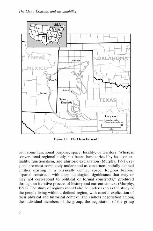
The de®nition of regions
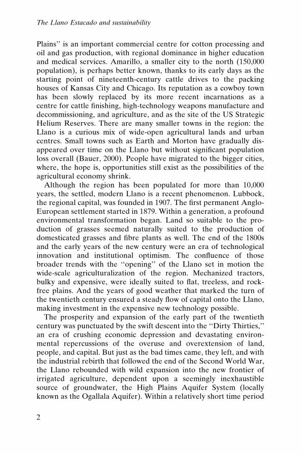
The Llano, ``broad, slightly rolling to undulating lands,'' has existedas a physiographically de®ned region since the ancient runoff of thethen-forming Rocky Mountain system of North America ``depositedthe smooth coalescing alluvial-fan plains of vast extent'' (Johnson,1931) that created these austere highlands (see ®gure 1.1). As with allregions, however, the southern plains exist as much more than aphysical entity. The peoples who have inhabited and traversed theplains for thousands of years have each de®ned the region for them-selves, and in turn have been de®ned by the region they created. Theregion is a physical entity; it is also a social construct, created both bythe inhabitants of the plains and by the rest of the nation.
The concept of regionality
A casual neglect of the careful consideration of what exactly de®nes aregion has been notable in the practice of regional analysis. Someregional scholars have raised the question of how regions are derived,differentiating among the classic terms of region as subdivided space
The Llano Estacado and sustainability
5
with some functional purpose, space, locality, or territory. Whereasconventional regional study has been characterized by its acontex-tuality, functionalism, and ahistoric explanation (Murphy, 1991), re-gions are most completely understood as constructs, socially de®nedentities existing in a physically de®ned space. Regions become``spatial constructs with deep ideological signi®cance that may ormay not correspond to political or formal constructs,'' producedthrough an iterative process of history and current context (Murphy,1991). The study of regions should also be undertaken as the study ofthe people living within a de®ned region, with careful explication oftheir physical and historical context. The endless negotiation amongthe individual members of the group, the negotiation of the group
Figure 1.1 The Llano Estacado
The Llano Estacado and sustainability
6
with the context, and the constraints on that negotiation from thesociocultural and political structures within which these componentsexist describe the complexity of regionality (Thrift, 1991: 461).
Moreover, the question of how deeply social structures are in¯u-enced by the speci®cs of context needs to be addressed in consider-ation of the meaning of a region. It has been noted that general pro-cesses which are recognizable despite being particularized by theirspeci®c expressions in a given regional setting may in fact be sothoroughly rede®ned by the context that they are, in the end, not sogeneral (Sayer, 1989). In other words, land distribution laws mightappear to be modi®ed for the semi-arid plains lands, but closer anal-ysis can reveal those laws to be the medium for perpetuating thesame general principles (individual ownership of privately heldproperty, yeomen farmers) that attended their inception and madethem impracticable for any region, regardless of climate or land use.Recognizing how context-dependent any given phenomenon may ormay not be is essential to determining those potential characteristicsof regionality that actually have meaning for describing the region.
Beyond the problematic nature of the de®nition of spatial, cultural,and physical regional boundaries is the issue of interpretation of ex-perience once it has been locationally ®xed. One group's under-standing of its history in a place will almost certainly differ fromanother's; the implications of this for the de®nition of a place areconsiderable. Research that ignores this complexity risks failure:``behaviour seems intelligible only to the extent that it resonates, notbecause we have articulated the constitutive structure of under-standing or feeling'' (Sayer, 1989: 256). The explanation of a region'shistory and present conditions must strike a balance between narra-tive and analysis; the reconstruction of the past in a narrative pre-®gures the depiction of current situation and conditions. And yet,without analysis of the abstracted trends and forces that are widelyrecognized, what is left is a mere retelling of events. Analysis withoutnarrative, however, results in narrow description without a sense ofcompeting forces and interpretations.
The socially de®ned region
Regions are both physically and socially constructed. Donald Worster,an eminent historian of the plains, de®nes a region as ``the outcomeof a dialogue between culture and nature'' (1994, xi); the SouthernHigh Plains is surely such a construction of a particular set of social
The Llano Estacado and sustainability
7
facts confronting certain immutable aspects of the environment. Andthe adaptations of law and custom by people set in an ideologicalcontext, confronting a set of environmental circumstances, areexplored below. Moreover, the West, as the larger contextual region,can be read as a ``battleground between the global economic systemof capitalism, which was amenable neither to environmental adapta-tion, conservation, nor democracy, and an alternative social ideal ofpublic planning, communal ownership of resources, and communitydecision making about their development'' (Worster, 1994: 25).About the Southern High Plains speci®cally it has been said: ``thePlains have been an endless puzzle and a considerable disappoint-ment to those who have tried to tame them'' (Worster, 1994: 91) ± orpossibly, to de®ne them.
Describing areas of semi-arid to arid climate, with few trees andlittle surface water, dominated by cotton and cattle, as a ``social unit. . . [with] measurable characteristics, largely determined by the dom-inant structural and functional aspects of the region,'' Cleland (1966:2) uses the term ``a sociological region,'' as opposed to a strictlyphysiographic region. He goes on to question whether the fact ofaridity (or semi-aridity) has further implications for the de®nition ofregions. Such regions must be comprehended, he concludes, throughthe multiplicity of sociocultural variables brought to prominence bythe fact of aridity (or semi-aridity). Adaptations to water-de®citareas, including those measures that seek to negate the impact of in-suf®cient water, have varied over time and economic space. Peopleliving on the Southern High Plains today structure their daily livesquite differently from their predecessors of 150 years ago or even 50years ago, and yet they are still constrained by the same physical factsof the region.
Arguably, ways of life in communities in largely agriculturalregions can be distinctly different in semi-arid and humid regions re-garding practices such as ``land use, water law, . . . political atti-tudes, . . . and other aspects of the culture including folklore, attitudes,and values of the people'' (Cleland, 1966: 3). Goldschmidt's (1978)intensive study of two irrigated agricultural communities in the Cen-tral Valley of California, one consisting primarily of family farms, theother of agro-industrial farms, illustrates how economic forms canproduce different societal forms within the same semi-arid area.
Comanche history (which predates Euro-American history in theregion) records a different physical world from that described byEuro-American settlers; the same physical setting was bounded very
The Llano Estacado and sustainability
8
differently for the two populations as well. Environmental phenom-ena, for example a period of drought, would have signi®cantly differ-ent resonance with an agrarian community than with a nomadicherding group. Thus, an essential aspect of regionality is who lived ina given space at a given time. The competing histories of the regionare the result of the several groups of humans who inhabited theplains over a period of about 10,000 years, beginning with paleo-hunter and gatherer groups and ending with the group currentlypopulating the plains, the descendants of immigrants and other Euro-Americans who moved onto the plains around the turn of the twen-tieth century. Each of these groups de®ned the region differently, andhad different relationships to the environment in which they madetheir homes. The earliest inhabitants de®ned the region quite locally:a particular lakebed, or riverine environment. Later, with the co-alescing of nomadic groups, the region expanded to cover the areatraversed in a year's cycle. The introduction of the horse brought anentirely new conception of the range of the region inhabited by theNative Americans. And, lastly, the agriculture-based colonization ofthe region ®xed forever the spatial limits of the Southern High Plains.
The overlapping human experiences on the Southern High Plains,and in particular that area known as the Llano Estacado, have con-tributed substantially to the region's claim to uniqueness. To becomeone of the last regions ``settled'' by European Americans, the South-ern High Plains were essentially depopulated and stripped of thephysical characteristics which had de®ned them. The region was thenmade over to the demands of the newest inhabitants. This was a pat-tern that was repeated throughout the American landscape (for ex-ample, see Cronon, 1983).
With the preceding in mind, the physical characteristics of theSouthern High Plains become the starting point for both narrativeand analysis. Taken together with the unfolding of events in the socialhistory of the area in the following chapters, this analysis allows theunderstanding of the region as a totality of location and experience.
Physical characteristics of the Llano Estacado
Physiography
The Southern High Plains, bordering the eastern face of the RockyMountains of North America, overlay an immense network of sub-terranean water deposits known commonly as the Ogallala Aquifer.
The Llano Estacado and sustainability
9
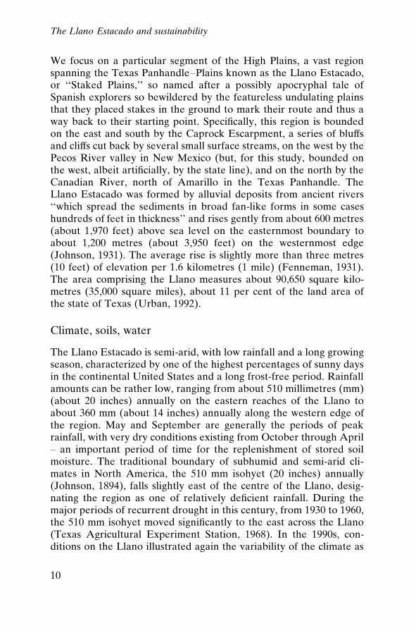
We focus on a particular segment of the High Plains, a vast regionspanning the Texas Panhandle±Plains known as the Llano Estacado,or ``Staked Plains,'' so named after a possibly apocryphal tale ofSpanish explorers so bewildered by the featureless undulating plainsthat they placed stakes in the ground to mark their route and thus away back to their starting point. Speci®cally, this region is boundedon the east and south by the Caprock Escarpment, a series of bluffsand cliffs cut back by several small surface streams, on the west by thePecos River valley in New Mexico (but, for this study, bounded onthe west, albeit arti®cially, by the state line), and on the north by theCanadian River, north of Amarillo in the Texas Panhandle. TheLlano Estacado was formed by alluvial deposits from ancient rivers``which spread the sediments in broad fan-like forms in some caseshundreds of feet in thickness'' and rises gently from about 600 metres(about 1,970 feet) above sea level on the easternmost boundary toabout 1,200 metres (about 3,950 feet) on the westernmost edge(Johnson, 1931). The average rise is slightly more than three metres(10 feet) of elevation per 1.6 kilometres (1 mile) (Fenneman, 1931).The area comprising the Llano measures about 90,650 square kilo-metres (35,000 square miles), about 11 per cent of the land area ofthe state of Texas (Urban, 1992).
Climate, soils, water
The Llano Estacado is semi-arid, with low rainfall and a long growingseason, characterized by one of the highest percentages of sunny daysin the continental United States and a long frost-free period. Rainfallamounts can be rather low, ranging from about 510 millimetres (mm)(about 20 inches) annually on the eastern reaches of the Llano toabout 360 mm (about 14 inches) annually along the western edge ofthe region. May and September are generally the periods of peakrainfall, with very dry conditions existing from October through April± an important period of time for the replenishment of stored soilmoisture. The traditional boundary of subhumid and semi-arid cli-mates in North America, the 510 mm isohyet (20 inches) annually(Johnson, 1894), falls slightly east of the centre of the Llano, desig-nating the region as one of relatively de®cient rainfall. During themajor periods of recurrent drought in this century, from 1930 to 1960,the 510 mm isohyet moved signi®cantly to the east across the Llano(Texas Agricultural Experiment Station, 1968). In the 1990s, con-ditions on the Llano illustrated again the variability of the climate as
The Llano Estacado and sustainability
10
the region underwent a drought considered by some to be the worstof the twentieth century, with rainfall amounts under 250 mm (lessthan 10 inches) for a period of nearly 12 months in 1996±1997.
Moderate temperatures and a fairly late occurrence of killing frosts(typically early November) contributed to the perception that theLlano was a natural agricultural region. Relatively early springs,de®ned by last frost generally occurring in mid-April, and soil tem-peratures reaching 10 degrees Celsius (50 degrees Fahrenheit) by theend of March, helped shape the region's agricultural base. All told,the Llano offers a growing season of about 185 days in its westernreaches and 225 days to the east. The region also receives a very highpercentage of possible sunshine ± one of the highest in the contiguousUnited States, about 70 per cent annually (Potts, Lewis, and Dories,1966).
An important agricultural climatic factor for the Llano, however, isthe virtually continuous wind. The seasonally very windy conditionshave desiccating effects on young crops (the windiest period of theyear tends to be from March to May, when planting occurs) and ex-acerbate soil erosion, a serious issue throughout the region. The pre-vailing wind direction is west and south-west for half the year (lateautumn through mid-spring) and south for the rest of the year (mid-spring through late autumn) (Lee et al., 1994). Studies such as thosecarried out by Lee and colleagues (1994), however, have concludedthat wind patterns are largely chaotic and highly variable as to direc-tion and speed.
This is a region of rich, dark brown to reddish brown soils, mostlysandy loams, clay loams, and some areas of clayey loams of uniformtexture (Livingston, 1952). These are soils created from the Quater-nary aeolian sand and loess sheet known as the Blackwell DrawFormation (Lee et al., 1994). All ®ne-textured, with the exception ofthe coarser sandier soils, these soils are very susceptible to wind andwater erosion, particularly after the removal of the native vegetativecover (Tharp, 1952). These are also soils with a very high organicmatter content, which Odum characterizes as those that support the``granaries of the world,'' assuming adequate rainfall (Odum, 1971:130). On the Llano, however, ``the very forces which have made itpossible for these soils to be so high in the chemical materials thatgive high fertility have also imposed limitation upon their productiv-ity,'' speci®cally ``. . . the low rainfall and occasional droughts'' thatlimit the leaching of organic material (Johnson, 1931: 73±4).
Other critical factors concerning soils on the Llano include their
The Llano Estacado and sustainability
11
high susceptibility to wind erosion, particularly the sandier soils ofthe western and southern parts of the region (Tharp, 1952). Addi-tionally, at varying depths, a thick layer of caliche, or hardpan, aclayey-limy stratum, appears throughout the Llano, indicative of lakedeposit stratigraphy (Darrow, 1958), from which the Caprock gets itsname (Johnson, 1931).
One of the most important features of the Southern High Plains isthe occurrence of extensive groundwater reserves. The aquifer un-derlying the region is part of the High Plains Regional Aquifer (alsoknown as the Ogallala Aquifer), a vast underground reservoir cover-ing parts of eight states from Wyoming and South Dakota in thenorth to Texas and New Mexico in the south, with an area of ap-proximately 450,660 square kilometres (about 174,000 square miles).The estimated drainable capacity of the system is approximately 4.01trillion cubic metres (3.25 billion acre-feet) (Kromm and White,1992a: 15).1 The aquifer was created from alluvial deposits of Qua-ternary or late Tertiary age, resulting in a formation of mixedsequences of clay, silt, sand, and gravel dropped by streams ¯owingdown the eastern face of the then-forming Rocky Mountains. TheOgallala is underlain by impervious shales of Permian to Cretaceousage, therefore only those parts of the formation with adequate thick-ness yield enough groundwater to sustain irrigation.
The depth of the layers of silt and sand above the impermeableshales, called locally the Caprock, is known as the saturated thicknessand ranges from 0 to 1,600 metres (0±5,250 feet) in the South Plains(Cronin, 1969). The mean saturated thickness over the entire aquifersystem is about 60 metres (about 200 feet); the mean saturatedthickness for the Texas portion of the aquifer is about 34 metres (112feet) (Kromm and White, 1992a: 16). Owing to pumping for irriga-tion, municipal, and domestic uses, this thickness has been reduced insome areas of the study area by more than 30 metres (roughly 100feet).
Recharge to the aquifer is minimal, averaging less than 25 milli-metres (1 inch) each year over the region. Less than 1 per cent of theavailable runoff percolates through the root zone. As a result, theHigh Plains Aquifer can be considered non-recharging, and an es-sentially ®nite water source. Nevertheless, the High Plains AquiferSystem provides the water for 20 per cent of all the irrigated acreagein the United States, some 30 per cent of all the water pumped forirrigation (Kromm and White, 1992b). This groundwater mining, theextraction of a non-renewable resource for consumption, led to pre-
The Llano Estacado and sustainability
12
dictions in the early 1980s, the last years of the golden age of irrigatedagriculture on the plains, of 40-year horizons for the feasibility ofgroundwater extraction from the aquifer (Walsh, 1980), a tenuousvision of sustainability for the region.
The question of sustainability
Given this overriding constraint, what can it mean to have a sus-tainable way of life on the Llano? In their essay, ``Making sense ofsustainability,'' Gale and Cordray (1994) reviewed nine versions ofsustainability, while Pretty and Howes (1993), in their study of agri-cultural sustainability in Great Britain, identi®ed a bewildering 75de®nitions. The concept, critics argue, is in danger of losing itsmeaning in such a plural conversation. In almost all cases, however,sustainability invokes the imperative to maintain something for thelonger term, beyond the current human generation. Speci®cally, theBrundtland Report of the World Commission on Environment andDevelopment contained this widely accepted, albeit broad, de®nitionof sustainability as ``development that meets the goals of the presentwithout compromising the ability of future generations to meet theirown needs'' (Brundtland, 1987: 3). De®ned in other literatures, thisbroad intergenerational notion ranges from the ``deferred consump-tion'' models of environmental economics to ecologists' defence ofregeneration of the environment over time (Hendee and Stankey,1973). Beyond this notion of intergenerational promise, the questionbecomes ``What is to be sustained?'' Is it the resource, the commu-nity, the ecosystem, or some of each of them? And how can a non-renewable resource dependency be construed in any manner assustainable?
Sustaining the resource
The most immediate interaction with the environment that createsthe greatest impacts on the Llano's environment is the agriculturalproduction system. Sustaining the resource base so as to preserve keyeconomic sectors is one de®nition of sustainability (Gale and Cor-dray, 1994). Sustainability is thus measured in the ongoing preserva-tion of a ``narrow range of ecosystem products de®ned as economi-cally valuable for existing markets'' or specialized goods for someparticular niche of the global economy in which the region has acomparative advantage (Gale and Cordray, 1994: 313).
The Llano Estacado and sustainability
13
The rationale for such a form of sustainability follows the argu-ments of resource economics. While uninterested in the environ-mental or community value of a system, such an approach is amenableto the reservation of the productive resource over time. The broadmeasure of this form of sustainability is, simply, highest sustainableyield through protection of the productive resource. In the context ofthe Llano, this means sustained use of the aquifer over time.
Over the decades of the twentieth century, cotton and cattle haveemerged as the dominant production systems on the Llano. Which ofthem has used the groundwater resource to the greatest productiveends and is likely to continue doing do so over time? Is irrigated agri-culture or cattle production more likely to support a longer-term sus-tainable community?
The dominant market products of the region, cattle and cotton, areboth water-demanding. Cotton, though brought to the region as adrought-tolerant crop, has become emblematic of irrigated agro-industry in terms of ecology and institutional support (Brooks andEmel, 1995). Cattle production, though less widely recognized as aregional irrigated product, is also dependent on groundwater re-sources. Water is essential throughout the many stages of the cattleproduction and feeding process; however, the largest portion of wateruse comes from the production of feed grains, speci®cally sorghum.
Sustaining the community
Sustaining the community is a goal of many of the ``schools of sus-tainability.'' De®ned by Gale and Cordray (1994: 316) as ``dependentsocial systems sustainability,'' this is an explicitly value-laden conceptthat asserts the importance or primacy of the existing human socialcon®guration, however de®ned. Strange (1984: 115) suggested thatthis is the goal of agriculture, to ``nourish a renewable pool of humanland stewards who can earn a healthy living by farming well.'' ForPretty and Howes (1993: 8), this form of sustainability must speci®-cally include ``a mechanism to maintain existing farm employmentand halt the continual decline in numbers of those directly employedon the land.''
In the case of the Llano Estacado, these ``stewards'' who are``employed'' on the land traditionally have been found on the familyfarm, generally characterized by its independence, owner-operation,commercial diversi®cation, and innovation. Identifying these farmsand measuring their fate is more dif®cult than the above de®nition
The Llano Estacado and sustainability
14
initially suggests. The modern, capitalized, family farm of the LlanoEstacado is now an agro-industrial ®rm and a government client(although decreasingly so), whose structure and operations are dif®-cult to bound in the farmhouse (Opie, 1993).
The protection of the rural community need not require the main-tenance of ``farmers in aspic'' (Bowers, 1995: 1242), however. Com-munity sustainability does not have to hold the rural cultural land-scape to an abstract and pristine standard; a more practical measurewould suf®ce. A general test of community and operator vitalitycould incorporate the size and variation of the total population overtime as well as the maintenance of the number and size of familyholdings. The measure here is the maintenance of population, espe-cially under conditions of economic or environmental shock, and thepreservation of independent family farm operations in the region.
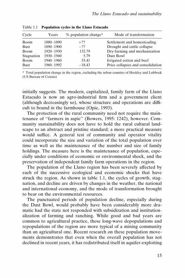
The population of the Llano region has been severely affected byeach of the successive ecological and economic shocks that havestruck the region. As shown in table 1.1, the cycles of growth, stag-nation, and decline are driven by changes in the weather, the nationaland international economy, and the mode of transformation broughtto bear on the environmental resources.
The punctuated periods of population decline, especially duringthe Dust Bowl, would probably have been considerably more dra-matic had the state not responded with subsidization and institution-alization of farming and ranching. While good and bad years arecommon to agricultural practice, these long-wave depopulations andrepopulations of the region are more typical of a mining communitythan an agricultural one. Recent research on these population move-ments demonstrates that even when the overall population has notdeclined in recent years, it has redistributed itself in aquifer-exploiting
Table 1.1 Population cycles in the Llano Estacado
Cycle Years % population change* Mode of transformation
Boom 1880±1890 �?? Settlement and homesteadingBust 1890±1900 ÿ?? Drought and cattle collapseBoom 1920±1930 132.79 Dry-farming and mechanizationStagnation 1930±1940 5.79 Dust BowlBoom 1940±1960 33.41 Irrigated cotton and beefBust 1960±1992 ÿ18.43 Price collapses and consolidation
* Total population change in the region, excluding the urban counties of Hockley and Lubbock(US Bureau of Census)
The Llano Estacado and sustainability
15
pockets; population has declined in some areas while growing inothers (White, 1994). The inability of the region to sustain growthstands out in its demographic history, as does the continual trans-formation of the production system to recapture wealth and drawback producers and consumers. This long-term demographic insta-bility is paralleled by a trend towards consolidation and small-holder decline that also threatens the ability of the region to sustaincommunity.
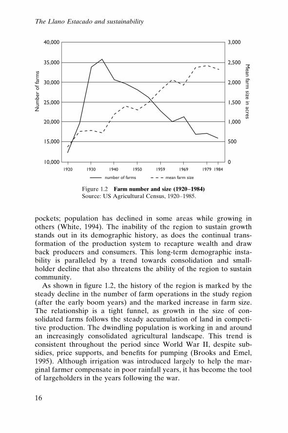
As shown in ®gure 1.2, the history of the region is marked by thesteady decline in the number of farm operations in the study region(after the early boom years) and the marked increase in farm size.The relationship is a tight funnel, as growth in the size of con-solidated farms follows the steady accumulation of land in competi-tive production. The dwindling population is working in and aroundan increasingly consolidated agricultural landscape. This trend isconsistent throughout the period since World War II, despite sub-sidies, price supports, and bene®ts for pumping (Brooks and Emel,1995). Although irrigation was introduced largely to help the mar-ginal farmer compensate in poor rainfall years, it has become the toolof largeholders in the years following the war.
Figure 1.2 Farm number and size (1920±1984)Source: US Agricultural Census, 1920±1985.
The Llano Estacado and sustainability
16
Sustaining the ecosystem
Sustaining the ecosystem for its own sake is another long-vauntedde®nition of sustainability. This form of sustainability has beenreferred to as ecosystem identity or ecosystem bene®t (Gale andCordray, 1994) and it is geared towards the preservation of naturalor pristine ecological conditions (Taylor, 1986). Generally rooted inan earth-centred position, it becomes anthropocentric when humaninterests are viewed broadly and in the long term.
The simplest measurement of this form of sustainability would bethe coverage and extent of the original and pristine ecological con-ditions. Under less stringent conditions, a test of this form of sus-tainability would measure whether or not a region has been trans-formed beyond the point of restoration or reclamation.
Although the extent of the original grasslands environment islargely nil, pockets of indigenous nature could conceivably remain,hidden in the interstices of agricultural production. The pre-Europeanrange complex that existed in the region (reconstructed by Tharp(1952)), dominated by buffalo grass (BuchloeÈ dactyloides), bluegrama (Bouteloua gracilis), and hairy grama (Bouteloua hirsuta), haslargely disappeared, but grasslands of some form persist in the openpasturage of the region. The degree to which these pastures havebeen spared cropping and have retained any of their original bioticqualities is a liberal test of ecological sustainability.
It would be a mistake to characterize these lands as pristine or evenas characteristic of grasslands environments. These were, by anystandard, destroyed a century ago. These lands are most likely toconsist predominantly of long-fallow ®elds, rotated out of production.The federal government's Conservation Reserve Program, wetlandsregulations on playa lakes, and other efforts at rationalizing cropproduction and conservation have favoured resting of the land. Thehigh percentage of non-cultivated land suggests an ecological reserveof relatively low pressure. Some of the indigenous (predating Euro-pean settlement) bird populations still persist, as well as smallermammals and reptiles. If the pre-modern ecology has not been sus-tained in the region, it has also not been obliterated beyond any hopeof recovery, except, of course, for those fully extirpated animal andplant species.
The question of whether the environment has been transformedbeyond the point of reclamation is complex. In the case of the semi-arid Llano, this is largely a test of deserti®cation, as broadly under-
The Llano Estacado and sustainability
17
stood by range and climate experts (Dregne, 1985). While the irre-versibility of this condition is debated, particularly under arid andsemi-arid conditions of rainfall variability, it is an important elementof true deserti®cation (Grainger, 1990). In the absence of true deser-ti®cation, it can be argued that the options available for the future arenot absolutely limited.
With this in mind, the relatively reduced rate of soil erosion in theregion since the 1940s points away from the total and irreversiblecollapse of the ecology. Irreversible soil erosion has occurred only ina small fraction of the study area, in south-western Gaines andCochran counties, where hummocky landforms and absolutely barrensoils appear (Brooks and Emel, 1995). The total drawdown of theaquifer might conceivably affect a handful of artesian springs but,apart from this, will have relatively little impact on the non-irrigatedparts of the surface ecology.
Further, the plant species that dominated in the region ± buffalograss, blue grama, and hairy grama, as well as Wright's three-awn andthree-awn grama (Bouteloua spp.) ± have not been eliminated alto-gether and do exist as dominant species elsewhere. If land is retiredfrom cultivation, it could be reseeded. For the countless possiblyunidenti®ed species that might have been lost in the transformation,re-establishment is obviously impossible. Certainly it would be im-possible to recreate pristine conditions, but many of the elements ofthe grasslands environment persist or could be reintroduced (Popperand Popper, 1994, 1991).
In sum, the agro-economy of the region fails the most stringenttests of ecological sustainability. The wholesale displacement of theindigenous environment was thorough and meticulous. The GreatPlains of the Native Americans, as they existed, were destroyed. Onthe other hand, there is no evidence to suggest that the future rangeof environmental conditions has been physiographically limited bythis century of exploitation. In this sense, sustainable futures mightstill be imagined, as long as the intractable calculus of a limited watersupply is part of those imaginings.
Organization of the book
This book is organized around the major phases of environmentaltransformation of the Llano. We trace the evolution of the ecologicalmakeup of the region from its creation as a vast glacial by-product,
The Llano Estacado and sustainability
18
through its gradual development as a shortgrass prairie/scrub com-plex, replete with massive herds of grazing animals, and inhabited bynomadic herders and gatherers. This region existed in slow evolutionfor thousands of years, populated by large groups of Native Ameri-cans who gradually differentiated themselves into tribes with discretecultures and customs. The arrival of Spanish explorers itself did littleto disturb this world, but what this event set in motion profoundlychanged the nature of the region.
The second part of this chapter begins with the arrival of the ®rstAnglo traders some 200 hundred years later, accelerating the processof environmental change, and the early beginnings of herding andranching of domesticated animals that set the stage for replacementof native species of animals and plants, as grazing became moreextensive.
The ®rst step in the transformation of the region, containment ofthe Native Americans making their homes on the plains, soon be-came an imperative for the settlement of the region in accordancewith Anglo-European desires. This story is told in chapter 3. The USmilitary was a major force in implementing federal-level policiesdirecting the removal and marginalization of the tribes who had livedon the Llano for centuries. The near-extinction of the buffalo, anessential partner in the Comanches' way of life, forced them furtherto the edges of existence. Within a few decades, agricultural settlerswere attempting to set up farming homesteads, replacing the cattleand ranching culture that had been greatly reduced by the cattle bustof the 1880s. Always a cyclical climate veering between severedrought and rainfall suf®ciency, the short-term climate began to havea serious impact on the progress of Anglo settlement.
The fourth chapter opens on an era of rainfall suf®ciency towardsthe turn of the twentieth century, an era that ushered in massiveenvironmental change on an unprecedented scale, the equivalent oftotal replacement. The removal of the Native Americans had been anessential aspect of this transformation and in this chapter we explainthe replacement of the few remaining indigenous people with Europ-ean-American agricultural settlers who, within a generation, hadembraced large machine technology and succeeded in replacing theindigenous grasslands with grain- and ®bre-based agriculture. Theupward spiral of development was accelerated by World War I,pushing demand and opening European markets to North Americangrains and ®bre. The replacement ecology proved disastrously non-
The Llano Estacado and sustainability
19
resilient, and with the onset of post-war drought, and buffeted by theinternational economic depression, the region collapsed in ecologicaland ®nancial catastrophe.
The ®fth chapter traces the recovery of the region, ecologically andeconomically, through the discovery of vast supplies of undergroundwater and the availability of technological innovations to access it.This began the era of exploitation and expansion on the Llano.Agricultural production grew rapidly, with cotton and beef leading inexports and in value. The endless water supply supported the expan-sion and the great increase in the standard of living for the people onthe Llano. The promise the region held for the early waves of settlerswas being met.
In the sixth chapter, we assess the current state of the environ-mental transformation of the Llano. Starting in the 1980s, the regionhas gone through a series of contractions and restructurings, attempt-ing to forge a new path into a sustainable future. Prolonged drought,global upheavals, and shifts in international trade have all playedsigni®cant roles in framing the future of the region and its people.
Finally, we look back over the history of the Llano and the envi-ronmental transformation that has unfolded inexorably to the currentuntenable state. How this region, home to nearly a million inhab-itants, can continue sustaining a way of life built on an ecologicalstructure of less than a century's making is the issue we have soughtto clarify, by weaving together the disparate strands of histories toldby succeeding groups of people on the Llano.
Note
1. An acre-foot is the amount of water needed to cover 1 acre (0.4047 hectares) ofland to a depth of one foot (about 0.3 metres), or about 326,000 gallons (1,233,910litres). Alternatively, one acre-foot is equivalent to 1,234 cubic metres.
The Llano Estacado and sustainability
20
2
Creation and change:12,000 b.p. to a.d. 1860
Creation
The Llano Estacado today is the result of millennia of geomorpho-logic process and a century or so of human endeavour. To fullyappreciate the latter, it helps to understand the former. Thousands ofyears of aggradation are responsible for the rich but vulnerable soils.Historically low rainfall amounts preserved the soils, while support-ing the variably scrubby and lush shortgrass terrain. For millions ofyears, animals and plants evolved to a form of stasis, interdependentand resilient. Over thousands of years, Native Americans graduallymade the plains their home, developing nomadic or locally agrarianways of life so as best to exploit the resources the region offered.Non-extractive resource use made the Native Americans' impact onthe Llano transitory, relative to the impacts of later European settlers.Overhunting or overgrazing in one season could be countered bylower reserves of wildlife in the next and a move to another region,giving the indigenous people a chance to survive and the indigenousanimals and plants a chance to recover. The symbiosis of the rela-tionship created between the native peoples and their physical envi-ronment set the stage for the disruption caused by the incursion ofEuropean explorers in the mid sixteenth century.
21
The Llano Estacado of Texas is a region of stark and forbiddingbeauty that resulted from hundreds of thousands of years of gradualcreation. To the extent that any place ever does, the Llano arrived ata point of natural stasis some thousands of years after the ®nal glaci-ation, the Wisconsin. Centuries of uplift forming the Rocky Moun-tains resulted in the deposit of millions of tons of alluvial materialscarried away from the eastern face of the developing chain by thou-sands of streams, rivers, and rivulets.
Plant life
For centuries, prior to Anglo settlement and development, a uniquevegetation±wildlife complex existed in the Southern High Plains.Extensive grasslands supported a wide diversity of animals, and pro-vided food for paleo-gatherers living on the plains. Some of thecomplexity of these ecological communities was uncovered in smallpockets of relict prairie communities that were found in the foothillsof the eastern Rocky Mountains in the 1950s (Livingston, 1952).However, this vegetative complex no longer exists on the Llano.
During the Late Mesozoic and Cenozoic eras, the great inland seasoriginally covering the area that eventually became most of thewestern United States during the Lower Cretaceous period receded.The development of vegetation on the plains is inextricably tied tothis stratigraphic history of the region. The ``distinctive ¯ora'' of theSouthern High Plains was derived originally from ``tropical or bordertropical ancestors'' (Darrow, 1958). The aggraded layers of marinesediments remaining when the inland seas receded from what becamethe Great Plains region supported the predecessor to the modernecology of the early grasslands complex, which probably emergedduring the Oligocene Period, when the south-western climate startedto differentiate into drier and less dry regions. This change was con-current with a general continent-wide cooling trend, which resulted ina drier, non-forested region bordered by forest to the east and west(Darrow, 1958). The actual species that populated the Great Plainsregion at that time are unknown, but fossil evidence suggests that theregion was probably covered by a subhumid grassy scrub vegetationdominated by grasses of the Stipa genus; others have posited thatinstead a tallgrass vegetation complex formed during the Oligoceneand included species of the Andropogon, Imperata, Eluyonurus,Trachypogon, and Tripascum genera (Darrow, 1958).
The grasslands evolved along with major Miocene-era stratigraphic
Creation and change
22
events, chie¯y the formation of the Rocky Mountains through blockfaulting and the general uplift of the Colorado plateau. One result ofthis massive movement was the eventual deposit of material thatformed the High Plains (Darrow, 1958). The ongoing trends of cool-ing and increasing aridity resulted in further development of grass-lands. Some have even suggested that long-term modern-day climaticconditions across the High Plains are analogous to those of the timespanning the Oligocene to the Pliocene (Darrow, 1958). Fossil evi-dence reveals grazing animals throughout the plains at this pointin time, with plants of higher drought tolerance and lower waterrequirements, largely of the Andropogon and Bouteloua genera,gradually replacing species that had greater water needs.
Glaciation appears to have had little impact on the further devel-opment of the grasslands climax ecology, although the impact on soilsis evident through the stratigraphic and fossil record. Darrow (1958)reports that by the end of the Pliocene, clear trends towards increas-ing aridity showed up in the fossil mollusc deposits, accompanied bydecreasing evidence of arboreal ¯ora and even prairie ¯ora. Heattributes the Llano's signi®cant caliche layer to the changing con-ditions that signalled increasing climatic dif®culty for pre-existingplants and wildlife; since the latest glacial advance, a ``distinctive butoscillating trend toward increasing aridity has taken place in theGreat Plains area'' (Darrow, 1958: 39).
The early modern ecology on the Llano (corresponding to theroughly 10,000 years between the most recent glacial advance and theadvent of Hispanic incursion) has been recreated through the use ofearly explorers' diaries and journals recording what they encounteredon the plains, along with studies like Livingston's (1952) examinationof relict prairie communities. Although Livingston's relict commun-ities were found on the high plains of Colorado, they are roughlyanalogous (with some slight variation) to the grassland complexesthat probably existed on the Llano. These relict prairie communitiesre¯ect ``true prairie'' complexes and were discovered in pocketsinterspersed with the more commonly occurring ``mixed prairie''climax communities. Livingston found that most relict communitiesappeared in areas with relatively high water tables. These more mesicenvironments appeared to be the primary reason the relict commun-ities survived in their scattered locations, possibly even from thetime of the glacial retreat. Despite the increasing aridity to the southand west, these relict communities were able to exploit the slightlywetter micro-environments at lower altitudes, in valley bottoms, and
Creation and change
23
in sloughs (Livingston, 1952). Also, some communities appeared tohave been pockets of re-introduced species, or to have been main-tained by the landowners in their original state for hay production.The relict true prairie communities are characterized by the domi-nance of certain indicator species, chief among them Sporobolus het-erolepis, Stipa spartea, and Sporobolus asper (Livingston, 1952).
By the time of the ®rst recorded ventures onto the Llano, theoscillating climatic conditions referred to by Darrow had trendedtowards the decidedly more arid. The notion of a Great AmericanDesert in the middle of the North American continent was created bythe earliest Anglo explorers, among them Stephen H. Long, whorecorded his impressions of his 1819±1821 travels through the vastgrasslands for the United States government.
This modern-era vegetation complex was dominated by blue grama(Bouteloua gracilis), and hairy grama grasses (Bouteloua hirsuta).The secondary species included buffalo grass (BuchloeÈ dactyloides).The grama grasses were reduced over time to secondary importanceby grazing.1 One-metre-tall wheat grasses were probably found inmicro-environments such as buffalo wallows, sloughs, or sinkholes.Other micro-environments, such as canyon ¯oors and dune areas,accommodated different plant complexes. For example, the canyon¯oors, cutbacks from the Escarpment, with their less sandy soils androlling topography, were localized sites of hair-leaved sand sage(Artemisia ®lifolia) with some more common grama grasses such asside oats (Avena spp.) and sweet bluestem (Andropogon spp.)(Tharp, 1952). The sandier dune areas with sparse grass cover, laterstressed by grazing, held more drought-resistant and stabilizing plantssuch as thread leaf sage (Artemisia spp.), covered spike drop-seed(Sporobolus sp.) and catclaw (Mimosa borealis) (Higgins and Barker,1982; Odum, 1971; Tharp, 1952). Weed species (sun¯owers (Heli-anthus spp.) and tumbleweed (Salsola spp.)) increased with increas-ing grazing and eventually the introduction of ploughing.
The radically restructured current-day vegetative complex of theLlano can be described as largely monocrop agriculture comple-mented by scrubby, drought-resistant species. Weed species such assun¯owers and tumbleweed have ¯ourished in the niches left vacantby the destruction of the shortgrass species: ``conspicuous annualforbs . . . such as the Russian thistle tumbleweed (Salsola) and sun-¯owers (Helianthus), owe their luxuriance to man's continual distur-bance of the soil'' (Odum, 1971: 389). Small reserves of grassland areprotected under the Forest Service of the United States Department
Creation and change
24
of Agriculture (USDA), through a programme, begun in the 1930s,designed to bring marginal Great Plains farmlands out of agriculturalproduction (West, 1990). Even these preserves, however, were andare treated as resources and are open to grazing.
Animals on the Llano
Climate changes may explain signi®cant alterations in animal life aswell. The presence of large lake basins on the Llano Estacado clearlyindicates that conditions at some time in the prehistoric past wereconsiderably wetter and cooler than they are at present. Precipitationmight have been twice that of the present, with mean annual temper-ature about 6 degrees Celsius (about 9 degrees Fahrenheit) cooler.After the cooler period came a progressive decrease in effectivemoisture, probably owing to decreasing precipitation and increasingtemperatures. The stratigraphic sequences in a series of sites in drawsin the region document this trend, showing a shift from free-¯owingstreams between approximately 13,000 and 12,000 years before thepresent (b.p.), to open ponds and lakes between 11,000 and 10,000b.p., and ®nally, to an aggrading marsh with little or no open waterfrom 10,000 to 6,300 b.p. (Bamforth, 1988). Evidence of extremearidity after 6,000 b.p. is found at Blackwater Draw and RattlesnakeDraw in eastern New Mexico and at Marks Beach in Texas, wherewells dated 6000±5000 b.p. were dug to a buried aquifer.
Two known important changes occurred with the fauna of theSouthern High Plains during the terminal Pleistocene and earlyHolocene. The ®rst of these was the extinction of most of the largemammal species in the region, which apparently occurred between11,000 and 10,000 b.p. The reasons for the extinction of the Pleisto-cene mammals are obscure and sometimes contradictory, but theextinctions are at least in part attributable to the appearance ofhuman hunters. Another major change occurred in the morphologyand, presumably, the adaptation of the bison or buffalo, the dominantlarge ungulate remaining. The modern (post-Pleistocene) Llano wasa habitat for a great diversity of wildlife, most of which was perma-nently displaced by the gradual incursion of Anglo settlers. Somespecies were made extinct; a very few, under current conditions, areregaining a place in the Llano's ecosystem. The few species thatremain in any numbers share the plains with the dominant largemammal inhabitants, cattle. Prior to large-scale Anglo introductions,grey wolves, bobcats, prairie dogs, black-footed ferrets, sharp-tailed
Creation and change
25
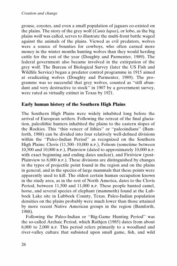
grouse, coyotes, and even a small population of jaguars co-existed onthe plains. The story of the grey wolf (Canis lupus), or lobo, as the bigplains wolf was called, serves to illustrate the multi-front battle wagedagainst the animals of the plains. Viewed as evil predators, wolveswere a source of bounties for cowboys, who often earned moremoney in the winter months hunting wolves than they would herdingcattle for the rest of the year (Doughty and Parmenter, 1989). Thefederal government also became involved in the extirpation of thegrey wolf. The Bureau of Biological Survey (later the US Fish andWildlife Service) began a predator control programme in 1915 aimedat eradicating wolves (Doughty and Parmenter, 1989). The pro-gramme was so successful that grey wolves, counted as ``still abun-dant and very destructive to stock'' in 1907 by a government survey,were rated as virtually extinct in Texas by 1921.
Early human history of the Southern High Plains
The Southern High Plains were widely inhabited long before thearrival of European settlers. Following the retreat of the ®nal glacia-tion, paleolithic hunters inhabited the plains to the eastern slopes ofthe Rockies. This ``thin veneer of lithics'' or ``paleoindians'' (Bam-forth, 1988) can be divided into four relatively well-de®ned divisionswithin the ``Paleo-Indian Period'' as recognized on the SouthernHigh Plains: Clovis (11,500±10,000 b.p.), Folsom (sometime between10,500 and 10,000 b.p.), Plainview (dated to approximately 10,000 b.p.with exact beginning and ending dates unclear), and Firstview (post-Plainview to 8,000 b.p.). These divisions are distinguished by changesin the types of projectile point found in the region and on the plainsin general, and in the species of large mammals that these points wereapparently used to kill. The oldest certain human occupation knownin the study area, as in the rest of North America, dates to the ClovisPeriod, between 11,500 and 11,000 b.p. These people hunted camel,horse, and several species of elephant (mammoth) found at the Lub-bock Lake site in Lubbock County, Texas. Paleo-Indian populationdensities on the plains probably were much lower than those attainedby more recent Native American groups in the region (Bamforth,1988).
Following the Paleo-Indian or ``Big-Game Hunting Period'' wasthe so-called Archaic Period, which Rathjen (1985) dates from about6,000 to 2,000 b.p. This period refers primarily to a woodland andriver-valley culture that subsisted upon small game, ®sh, and wild
Creation and change
26
plants. A site thought to be representative of this period (age-bracketed between 4,000 b.p. and 1,000 b.p.) in Randall County,Texas, called Little Sunday Canyon (a tributary to Palo DuroCanyon), has yielded stone artifacts, grinding tools, hide scrapers,choppers, and milling stones.
The Woodland tradition emerged around 2,000 b.p. and is signalledby the appearance of pottery derived from the Eastern Woodland.This is the probable time of the introduction of maize agriculture.Around 1,500 b.p., emigrants from the woodlands of the MississippiValley and further east brought gardening to the river bottoms of theMissouri and its tributaries. These people and their successors livedin earth lodges or grass-domed houses, growing corn, squash, maize,and tobacco. They travelled on foot and hunted buffalo and antelope,at times driving the animals over bluffs to their deaths. The buffalowas important to their economy, but not critically so (Rathjen, 1985).
Plains Village culture dominated the Southern Plains for 300±500years. The Plains Village tradition included successful agriculture ±speci®cally the cultivation of maize, beans, and squash. Huntingcontinued to be an important component. The most importantarcheological site in the study area is the Antelope Creek Focus,located along the Canadian River and its tributary streams. Theseruins are dated from a.d. 1350 to 1450, on the evidence of potteryshards probably derived from trade with the Puebloans to the west(Rathjen, 1985).2 The ruins once were thought to be evidence of aneastward extension of Puebloan peoples, but recent research contra-dicts this and has shown the ruins to be more recent. The AntelopeCreek people are now thought to have been pottery-making Plainspeople who ®rst appeared in the central plains shortly after 900 andwho gradually migrated into the Canadian River valley about two orthree centuries later (Rathjen, 1985: 42). Similarities exist betweenthe Antelope Creek Focus and the Upper Republican culture. Hyde(1959) describes the Upper Republican culture as Caddoan or``primitive Pawnee,'' from the east. Their pottery was consideredsimilar to that of the ``primitive Pawnees'' who had come into theHigh Plains along the Upper Republican River valley in Nebraska atabout the same time. These groups of Caddoan origin (``MoundBuilders'' of the Mississippi) had settled on the headwaters of theCanadian River in the Texas Panhandle after 1200. Archeologicaldating of pottery shards found in the ruins of adobe and stone slabhouses at the Texas Panhandle Pueblo site suggest the ruins are fromthe period 1300±1500 (Hyde, 1959).
Creation and change
27
To the south-west, the Puebloans planted corn, tobacco, cotton,squash, and beans. They wove cloth and made pottery, and by 1000the Puebloan culture was spreading widely throughout the NorthAmerican South-west. One large ruin attributed to the Puebloanculture was unearthed along the Canadian River in the Texas Pan-handle. In later years, the Apaches would drive the Puebloans out ofthe trans-Pecos area.
Change on the Llano
Some histories of the Southern High Plains suggest that it was onlythe landscape Anglo-European settlers had to conquer. Theseaccounts imply that no one dwelled on the grasslands; there wereonly the ground to break, fences to erect, homes to build, and cropsto bring in. Clearly, nothing could be further from the truth. Theentire area was criss-crossed with people trading, following the buf-falo herds, warring with one another, grazing horse herds, and tend-ing ®elds, people who had been there for more than 300 years, andpossibly as much as 1,000, prior to the arrival of Anglo-Europeansettlers. In recent history, the Apaches, Comanches, Kiowas, andKiowa Apaches all inhabited the Southern High Plains. The earliestEuropean contacts with any tribes on the plains were recorded in1541 by the Spanish under Francisco Va squez de Coronado, whotravelled from Pecos Pueblo through north-eastern New Mexico,across the northern Texas Panhandle, and into Oklahoma andKansas. In 1542, according to Hyde's (1959) interpretation of theCoronado documents, the Apaches controlled the southern plains intheir entirety from northern Texas up to the Arkansas River. Aroundthis time, Apachean groups apparently occupied the western plainsfrom south-eastern Wyoming down through eastern Colorado andwestern Kansas into north-western Texas (Hyde, 1959).
Early Spanish descriptions suggest that the ®rst Apache occupantsof the region were full-time hunter-gatherers, semi-nomadic groupsusing dog-pulled travoises to move between seasonal camps. TheSpanish adopted the Puebloan ZunÄ is' identi®cation of these peopleas Apaches, or ``enemies.'' The Apaches called themselves People,T'Inde, or by variants of the term Naizhan, meaning ``Our Kind''(Fehrenbach, 1994: 130±1). Linguistic evidence suggests that thePlains Apaches separated from their northern Athapaskan ancestors(the groups who came over the Siberian land bridge) substantiallybefore white contact, possibly as early as 600. Information gathered
Creation and change
28
by the Spanish from the Puebloans of New Mexico indicates thatthese Apaches arrived on the Southern High Plains around 1500(Hyde, 1959). In the sixteenth century, the world of these Nativepeoples would be irrevocably altered by the arrival of Spanish``explorers'' from the south. Alternating between cooperation andtrade, and conquest and division, the relationships among the tribesand with the new presence on the plains were complex and ¯uid. Butthe Europeans brought horses and guns to the region, and changedthe course of history.
By the time of Spanish incursion, Apaches were living as part-timefarmers, spending the planting and harvesting seasons in small ran-cherõÂas dispersed throughout their territory and living the rest of theyear as nomadic buffalo hunters. They were the ®rst to acquire thehorse from the Spanish, but they apparently did not learn horse-breeding as the Comanches did. When sedentary, they lived in adobehouses with ¯at roofs something akin to those of the Puebloans.Some bands, like the Jicarillas, were advanced in agrarianism; othersremained more nomadic.
In 1598, the Spaniard ZaldõÂvar came upon one of the ApacherancherõÂas:
Going on along a large river, evidently the upper Canadian, ZaldõÂvar metmore Vaqueros returning to the plains after a trading expedition to Picurisand Taos, where they had exchanged dried meat, tallow, hides, and salt formaize, pottery, cotton cloaks, and small green stones (turquoises). HereZaldõÂvar saw an Apache rancherõÂa or camp of ®fty skin tipis colored red andwhite, ``with ¯aps and openings, all very neat.'' . . . This was in the autumn of1598. (Hyde, 1959: 9)
By the time the Spaniards were established at Santa Fe (after 1609),the Apaches still dominated the Southern High Plains. TheComanches, who commanded the area when the Euro-Americansettlers began pouring into the region, did not arrive on the plainsuntil the beginning of the eighteenth century. And although theComanches and the Utes raided and travelled as far south as theSpanish settlements in New Mexico, they made no attempts to occupythese lands permanently until later. Bamforth (1988) contends thatsome semblance of tribal locations can be reconstructed c. 1650 butmore reliable schemas are not possible until after 1700. He cautionsthat, in considering tribal ``territories'' on the plains, it is important toremember that the known buffalo-hunting groups in the region werehighly mobile. The introduction of the horse obviously increased this
Creation and change
29
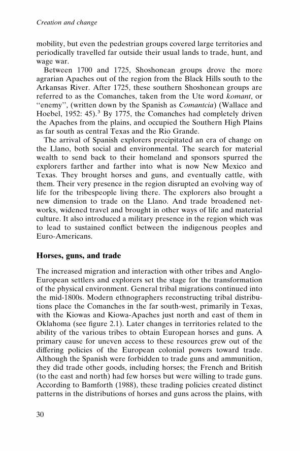
mobility, but even the pedestrian groups covered large territories andperiodically travelled far outside their usual lands to trade, hunt, andwage war.
Between 1700 and 1725, Shoshonean groups drove the moreagrarian Apaches out of the region from the Black Hills south to theArkansas River. After 1725, these southern Shoshonean groups arereferred to as the Comanches, taken from the Ute word komant, or``enemy'', (written down by the Spanish as Comantcia) (Wallace andHoebel, 1952: 45).3 By 1775, the Comanches had completely driventhe Apaches from the plains, and occupied the Southern High Plainsas far south as central Texas and the Rio Grande.
The arrival of Spanish explorers precipitated an era of change onthe Llano, both social and environmental. The search for materialwealth to send back to their homeland and sponsors spurred theexplorers farther and farther into what is now New Mexico andTexas. They brought horses and guns, and eventually cattle, withthem. Their very presence in the region disrupted an evolving way oflife for the tribespeople living there. The explorers also brought anew dimension to trade on the Llano. And trade broadened net-works, widened travel and brought in other ways of life and materialculture. It also introduced a military presence in the region which wasto lead to sustained con¯ict between the indigenous peoples andEuro-Americans.
Horses, guns, and trade
The increased migration and interaction with other tribes and Anglo-European settlers and explorers set the stage for the transformationof the physical environment. General tribal migrations continued intothe mid-1800s. Modern ethnographers reconstructing tribal distribu-tions place the Comanches in the far south-west, primarily in Texas,with the Kiowas and Kiowa-Apaches just north and east of them inOklahoma (see ®gure 2.1). Later changes in territories related to theability of the various tribes to obtain European horses and guns. Aprimary cause for uneven access to these resources grew out of thediffering policies of the European colonial powers toward trade.Although the Spanish were forbidden to trade guns and ammunition,they did trade other goods, including horses; the French and British(to the east and north) had few horses but were willing to trade guns.According to Bamforth (1988), these trading policies created distinctpatterns in the distributions of horses and guns across the plains, with
Creation and change
30
the numbers of horses increasing toward the south-west and thenumbers of guns increasing toward the north-east. The ®rst groups toobtain horses (which were traded earlier than the guns) were thosenearest to the Spanish, speci®cally the tribes in the Chihuahua areaof Mexico (Hyde, 1959). They soon learned to ride, and by 1560 these``Mexican Indians'' had a good supply of horses (ibid.). By the late1600s, the Mendoza-Lo pez entrada into Texas encountered mountedApaches along the Pecos River.
Figure 2.1 ComancherõÂa and the Southern Plains in the early nineteenth centurySource: Noyes, 1993: 84.
Creation and change
31
The Plains Apaches rapidly obtained substantial numbers of horsesand developed a style of mounted warfare, giving them a dramaticmilitary advantage over their neighbours. Horses then spread tothe Caddoan tribes to the east by 1700 and were obtained in largenumbers after 1690 by the Utes and the Comanches. At the sametime, these groups distributed horses to their northern relatives; theShoshones in Montana and Wyoming were raiding the Crow and theBlackfoot on horseback by 1730. The most immediate impact ofthe adoption of horses was the substantial increase in the area overwhich these groups could travel, and the advantage gained in huntingthe large mammals of the plains, particularly buffalo. With the in-crease in horse herding, changes in vegetation patterns probably soonfollowed.
At the same time, the Caddoan groups in the eastern plains beganto trade for guns with the French. Around 1740, the Comanchesmade an alliance with the Caddoan tribes in eastern Nebraska,Oklahoma, and Texas, obtaining for themselves a reliable source ofguns. By 1750, every Comanche warrior coming to Taos to tradecarried a French musket (Hyde, 1959). The refusal of the Spanish tosupply the Apaches with guns even in the face of this situation led toultimate Comanche dominance.
The advantage created by horses and guns enabled the Comanchesto accomplish their conquest of the southern plains in less than ®ftyyears, driving the Plains Apaches south of the Canadian River (in thepresent-day Texas Panhandle) (Noyes, 1993). The southern plains,which the Spaniards had long considered a part of ApacherõÂa, werebecoming ComancherõÂa. The Comanches were thus the last ``®rstpeople'' on the Southern High Plains; they were certainly the mostrenowned, and controlled the Southern High Plains when Europeanscouts, buffalo hidemen, and settlers began trickling into the area.
Comanches and Europeans on the Southern High Plains
The incursion of Europeans onto the Southern High Plains broughtabout major disruptions in the course of human and environmentalhistory in the region. The Spanish in particular initiated large build-ing projects, erecting missions and governing palaces on a scale notseen before. Large tracts of land were brought under cultivation, withrudimentary irrigation works, and small-scale mining operations werebegun in search of elusive lodes of gold. These were unprecedentedperturbations on the landscape: until then, agriculture had been lim-
Creation and change
32
ited to small riverine plots, pueblos were low-scaled adobe and stonestructures, and pottery had been the primary extractive activity. TheEuropeans also introduced large-scale herding, breeding horses tosupport exploration and military expeditions.
Trade networks and militarization of the region
Trade among the native tribes and the settlers to the east and westsoon emerged as a major transformational activity that would event-ually change the physical and social world of the Llano. In manyways, the trade networks that developed on the Llano and movedacross the plains were the start of the transformation of the indige-nous ecology. Not only were major trading routes built, with perma-nent structures, trading posts, and forts to protect them, but foreignmaterials and animals were also introduced. Guns, in the hands of thetribal peoples and the traders, had a drastic impact on the numbers ofwildlife in the area. And both the French and the Spanish were veryinterested in maintaining or increasing trade with the Native Ameri-cans for a number of reasons ± to keep peace, garner wealth, andobtain necessities, for example. It has been argued that by the middleof the seventeenth century, the horse trade may have replaced buffalohunting as the primary mode of production in Comanche life, fullyinvolving Comanches in the developing Euro-American politicaleconomy (Foster, 1991). Even food supplies may have been obtainedmore by trading horses than by hunting or plant-gathering. Althoughthe Spanish attempted to regulate Comanche trade by controlling thefrequency and conditions of Pueblo trade fairs, the Comanchesremained independent from the Spanish.
The Comanches made their ®rst contacts with Anglo-Americantraders along the Santa Fe Trail, the 900-mile trail that was built be-tween Independence, Missouri, and the mission of Santa Fe, in theearly 1800s. Arguably, the ®rst major environmental disruption in themodern history of the region, the gradual slaughter of the great buf-falo herds on the plains, can be traced to the arrival of Anglo traders(®gure 2.2). The ®rst traders, the Bent Brothers and Ceran St Vrain,were operating in Comanche country by 1829, and built trading postsfor Comanches and Kiowas. In 1833±1834, these traders built a largeadobe trading post known as Bent's Fort, on the Arkansas River inwhat is now south-eastern Colorado. The situation of this post on theSanta Fe Trail made it a rendez-vous for scores of traders, particu-larly fur traders: the fur trade was at its zenith from 1807 to 1843.4
Creation and change
33
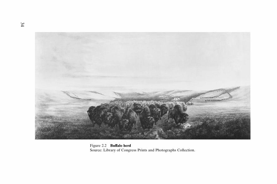
Figure 2.2 Buffalo herdSource: Library of Congress Prints and Photographs Collection.
34
Comanche trade in horses and mules remained crucial to the NewMexican economy from the mid eighteenth century to the early 1870sand was a signi®cant element of the Texan, Louisianan, and Missou-rian economies up to the Civil War. Foster (1991) argues that thistrade also enabled the Comanches to survive the catastrophic reduc-tions in wildlife and widening land restrictions on the plains. By 1847,the Comanches were experiencing dif®culty in ®nding buffalo andother herd animals. It is estimated that by the 1830s, after the intro-duction of guns and Anglo traders, the huge southern herd of buffalowas reduced by 20 million to 35 million animals. A Special (Indian)Agent Neighbors reported in 1847 that ``buffalo and other game havealmost entirely disappeared from our prairies'' (cited in Foster, 1991:47). Some have attributed the disappearance to an underlying eco-logical cause (e.g., climate change), but most assign the loss to over-hunting and land settlement (Richardson, 1933). Findley (1991: 110),writing of the Santa Fe trail, asserts that
[t]he buffalo hunt as a macho ritual began to draw sporting parties from theEast, and the market value of hides and horn brought professional hunters.Indian depredations increased; clashes were numerous, and Congress waspressured to legislate the Indians onto reservations, a job for the Army. By1867 Kiowa Chief Satanta remarked: ``There are no longer any buffaloesaround here, nor anything we can kill to live on.''
The trade in buffalo hides was highly pro®table. In the summer of1840, ®fteen thousand buffalo robes and a large quantity of furs weredelivered to St Louis. In the winter of 1841/42, eleven hundred balesof buffalo robes, weighing about 50 tonnes, along with a tonne ofbeaver pelts, were shipped out of the southern plains. On the tripswest, the Bent wagons hauled trading goods and government goodsto be distributed to the Native Americans as annuities for ceded land(Gard, 1959).
The sporadic hostilities between Native Americans and tradingcaravans created a furore, not only about the violence but also be-cause of the threat to the Santa Fe trade. As a result, the governor ofMissouri asked for assistance from the military; President AndrewJackson authorized an infantry escort for the 1829 caravan on theSanta Fe Trail. This introduction of a military presence markedthe beginning of the so-called Indian Wars. Skirmishing, mistakenidentities, revenge killings, and other violent acts were to plaguethe efforts of the Native Americans and newcomers to deal with oneanother for years.
Creation and change
35
The war with Mexico
Before 1821, Santa Fe was the northernmost provincial capital ofNew Spain, and Americans who ventured there risked ®nes, con®sca-tion of goods, and imprisonment. In 1821, Mexico declared its inde-pendence and before the year was out, traders from the Americanfrontier were coming in along the Santa Fe Trail. Early in 1823, theComanche chiefs signed a peace treaty with Mexico, which estab-lished rules for trade between the two nations and widened the net-work of interaction among people in the region.
Comanche trails into Mexico are still visible on the landscape. Afew miles north of the Rio Grande, near the present-day city of DelRio, many trails out of ComancherõÂa converged into a broad road-way, ``beaten by the passage of thousands of unshod Comancheponies'' (Fehrenbach, 1994: 251). This trail, called the ComancheTrace, was a distinct landmark running for miles south of the RioGrande, gradually disappearing as the bands dispersed across north-ern Mexico. Another trail, farther west, went through the SantaElena canyon. Other trails ran into the Mexican states of Tamaulipas,Coahuila, Nuevo Leo n, and Chihuahua, over distances of hundredsof miles.
The part of the southern plains now known as Texas had beenacquired by the ¯edgling United States with the Louisiana Purchasein 1803; the territory was subsequently relinquished to Mexico in1819. The arrival of Anglo settlers in the Texas territory in the 1820ssoon led to tensions with the Mexican government. A decade ofskirmishing led to the Texas Revolution, launched in October 1835.After gaining independence from Mexico, the Republic of Texasrequested annexation by the United States. In 1845, Texas wasadmitted to the Union, and shortly thereafter a boundary disputewith Mexico resulted in renewed hostilities. The war between Texas(or the United States) and Mexico was fought from 1846 to 1848. Theincreasing pressure for expansion of US territory in the 1840s, themovement of US citizens into northern Mexico, the political instabil-ity of the Mexican government, and ®nancial claims of US citizensagainst Mexico also accelerated the push to war (Oliva, 1989). TheTreaty of Guadalupe Hidalgo, signed in 1848, which detailed the areato be ceded to the United States and ®xing the US/Texas boundarywith Mexico at the Rio Grande, ended the war. This included the vastregion west of Texas to the Paci®c Ocean and north to the Oregonterritory. The US agreed to pay Mexico US$15 million and to assume
Creation and change
36
$3.5 million in claims. The war cost the US over 12,000 soldiers(almost 11,000 died of disease) and $100 million. New Mexico be-came a US territory in 1848.
The Santa Fe trail, the longest of the great trails west, was a majorroute for military transport of soldiers and supplies during the warwith Mexico; the trading route became an important means of ful®ll-ing the expansionist goals of the US government (Oliva, 1989).Native American resistance along the Santa Fe trail increased duringthis period and the Indian Battalion of Missouri Volunteers under thecommand of Colonel William Gilpin was stationed along the trail toprovide military protection in late 1847 and part of 1848 (Oliva,1989).
ComancherõÂa in the nineteenth century
The Comanche bands reached their greatest strength during the ®rsthalf of the nineteenth century as they maintained dominance over theLlano. Fehrenbach (1994) estimates there were around 20,000±30,000 Comanches at this peak. Their territory stretched from theBrazos River to the Arkansas River on the east and north, and to theSangre de Cristo Mountains and the Pecos River on the west andsouth. The only real limitation on Comanche activity in the early partof the 1800s was disease. Smallpox, measles, and cholera appearedamong the Comanches in 1816 and again in 1839. Whole bands weredecimated. Venereal disease was rampant among the mestizo popu-lation, and soon spread to the Comanches. Syphilis became epidemic,and by the 1830s and 1840s evidence of European diseases was fre-quent north of the Red River, all presumably contracted from theSpanish (Fehrenbach, 1994).
Histories of the period suggest that many different Native Ameri-can groups also were active in this region. The Comanches and theOsages, generally enemies, coexisted peacefully on occasion, forexample. There were complicated relationships between particulargroups, usually traders, and certain chiefs. Quapaws, Arapahoes,Taovayases, Pawnees, Wichitans, Osages, and others lived aroundeach other or at least crossed each other's pathways. The Comanche±Ute wars had decreased in intensity, in part because the Comancheswere raiding in the more pro®table areas of Texas and Mexico, ratherthan westward into New Mexico.
The forced migrations of Native Americans from the easternUnited States, which caused such turmoil in the 1830s and led to the
Creation and change
37
death of so many peoples, soon began to have an impact on theactivities of the people on the plains. Richardson (1991: 32) writesthat ``[t]housands of these red men from east of the Mississippi (whowere being dispossessed of their lands) were located near theComanche hunting grounds during the period between 1825 and1840.'' The Indian Removal Act, passed in 1830 by the US Congress,compelled thousands of eastern Native Americans to move to whatwas known as Indian Territory, a region in present-day easternOklahoma and Kansas and western Missouri and Arkansas. To pro-tect their territory, the Comanches fought the newcomers at everyturn. The US government, fearing that eastern Native Americanswould refuse to move into such a hostile region, sent delegations in1832 and 1833 to establish peace between the various Native Ameri-can groups, particularly the Comanches and the eastern tribes.
Settlers continued to arrive in Texas during this period, in part be-cause the commercial interests in Texas were advertising in Europe.5During the 1840s, thousands of Germans and Irish emigrated toTexas, settling in the north and west, much closer to Comanche ter-ritory than previous immigrants (Rollings, 1989). This brought themwell within range of Comanche raiding and infringed upon the livingspace of the Native Americans. Violence spread along the frontier. Inthe ®rst three years after Texas achieved statehood, 70,000 peoplearrived, many of them settling in the western part near ComancherõÂa.After Texas gained its independence from Mexico, the Texas gov-ernment had offered free homesteads of 518 hectares (1,280 acres) tonew settlers. Thousands of newcomers, refugees from the generaleconomic depression in the United States at that time, accepted theland offers and began moving west into ComancherõÂa. The Comanchesattacked these squatters; the Texans retaliated, forming local militaryunits and groups of ``Indian ®ghters'' like the Texas Rangers.
The discovery of gold in California in 1848 brought another ¯oodof Euro-Americans through the region, using the Santa Fe Trail andthe Canadian River to make their way west and further challengingthe rights of the Comanches to control the plains. These travellerskilled Comanche game, used precious wood, water, and grass, andotherwise disrupted Comanche lives (Rollings, 1989). Gold beckonedto a different sort of immigrant: poverty-stricken slum dwellers fromthe Atlantic coastal cities, as well as fortune-hunters from the farmingfrontier. They brought disease with them and spread a virulent pla-gue of Asian cholera across the whole expanse of the southern plains.The Comanches, who had kept the Europeans out of their camps,
Creation and change
38
had not understood the importance of typical disease vectors likepolluted water, clothing, and other objects any more than had theEuropeans. During this period, nearly all of the leaders and manymembers of the southern Penateka bands were killed by cholera orsmallpox (Fehrenbach, 1994).
With statehood for Texas, the US government took on the re-sponsibility of protecting the settlers, the eastern Native Americanswho were forced west, and the Mexicans who remained after the 1848Mexican Cession. The government also inherited the Texans andtheir running war with the Comanches. In 1849, a line of forts wasbuilt across Texas for the purpose of protecting settlers and reducingthe con¯ict. The military presence encouraged European settlersto move further west into Comanche territory. Moreover, for thoseNative Americans who had never completely reconciled their rela-tionship with the Santa Fe Trail traf®c, the newly arriving railroadwas terrifying ± it now brought hordes of white people through, andto, their lands. In 1830, the entire country had only 117 kilometres(roughly 73 miles) of railroad tracks; ten years later, the trackincreased to 5,358 kilometres (3,328 miles), then stretched to 14,259(8,879 miles) in 1850 and 49,324 (30,636 miles) in 1860 ± more than inall of Europe at that time (Takaki, 1993: 100). (The railroad ultimatelyreached Santa Fe in 1880, thus concluding the story of the Santa FeTrail, the longest-lasting of the great trails west and the site of themost resistance and raiding from Native Americans (Findley, 1991).
By the late 1850s, the Comanches were more or less completelysurrounded by soldiers, well-armed settlers, and ``Indian ®ghters,'' allin the effort to secure ever more land for ``settlement.'' There waslittle refuge in ComancherõÂa any more; even peaceful Native Ameri-cans were indiscriminately attacked by whites who did not know orcare about the difference. Because of this, the Bureau of IndianAffairs Agent for Texas, Robert Neighbors, convinced the federalgovernment to provide land for the Native Americans outside ofTexas. In 1858, all Comanche bands as well as other Native Americangroups were to move north of the Red River, which ¯ows east acrossthe Texas Panhandle, becoming the boundary between Texas andOklahoma. Only 384 Comanches did so (Rollings, 1989). Comanchesliving outside Texas had to reach an accommodation with the UpperPlatte and Upper Arkansas agents to have access to licensed traders,retain some measure of safety for their families, and be relatively freefrom military interference (Foster, 1991). These agreements werereached between certain band leaders and government of®cials.
Creation and change
39
The relationship established between Texans and the Comanches,uneasy at best, was distorted by ignorance and misperception. On theone hand, Texans viewed Native Americans as the opposite of ``civi-lized'' Euro-Americans ± bent on the ``wanton destruction of frontierhomesteads.'' On the other hand, when trade with the Comancheswas desirable, those same wanton, barbarous thieves were toleratedand even defended. By the 1840s, however, Comanche land was asimportant to Texans as Comanche trade. The ``ruthless Comanchewarrior'' was a representation useful for justifying both Anglo occu-pation of Comanche lands and the establishment of an independentAnglo-American government and militia to protect the frontier better.For the Comanches, the loss of wild animal populations meant thatraiding and trading were more important than ever, thus ensuringcontinuing con¯ict between the Native Americans and the new-comers. As Hagan, in his excellent history of the allotment, or reser-vation, years, pointed out (1976: 13):
The Comanches had come to depend upon other items available only fromthe Comanchero or his eastern counterpart. The hard bread, sugar, andcoffee these traders brought to the plains enriched the Comanche diet, andthe ®rearms, kettles, and metal tools simpli®ed the Indian's struggle for ex-istence. The Comanches were nomads, but even the Quahadas had becomedependent on trade goods long before they became reservation Indians.
The ®nal act was about to unfold for the Comanches. The pressureto preserve the Llano for settlement dictated the removal of theComanches. The means were less than creditable, but very effective.
Life on the Llano had changed, slowly at ®rst, but irreversibly. Bythe middle of the nineteenth century, the Comanches were pushed tothe margins of their own lands, of ComancherõÂa. Settlers were movinginto the area, and ®nding vast reaches of what appeared to them to beunused land. The robustness of the ecological foundation was notapparent to these newcomers, much less its complexity. What hadtaken 100 centuries to evolve was about to be undone in a scanthuman generation, measurable in decades.
Notes
1. The ranching era complex has been reconstructed as: buffalo grass (®rst rank),blue grama (second rank), hairy grama (third rank), plains, Reverchon's, andWright's three-awn and three-awn grama (Bouteloua sp.) (fourth rank), and,lastly, 37 other forbs and short grasses (®fth rank) (Tharp, 1952).
2. All dates hereinafter are a.d., unless denoted b.p.
Creation and change
40
3. The cause of the earliest migrations on the plains, particularly those of the Numicand Athapaskan groups before European contact, are poorly understood. Onetheory is that the Shoshones, or Comanches, moved south because of pressurefrom the Black Hills Dakotas. Others have posited that the Comanches wereseeking the larger buffalo herds and the Spanish horse herds to the south (Feh-renbach, 1994). Others again counter that, in fact, buffalo herds were smaller inthe southern plains (Bamforth, 1988).
4. According to Gard (1959), traders traf®cked in alcohol for hides from NativeAmericans. As a tragic result of this accord, ``the tribesmen to satisfy their cravingfor strong drink, killed very nearly all the buffaloes from certain ranges'' (Gard,1959: 57).
5. This method of advertising, boosterism, is discussed in greater detail in chapter 3in the context of Anglo settlement patterns in the study area.
Creation and change
41
3
Early stages of transformation:1860 to 1900
The decline of ComancherõÂa
``What shall we do with the Indians?'' asked a writer for The Nation in 1867,as the Irish crews of the Union Paci®c and the Chinese crews of the CentralPaci®c raced to complete the transcontinental railroad. The ``highways tothe Paci®c'' must not be obstructed. The Indians must either be ``exter-minated'' or subjected to the ``law and habits of industry.'' Civilizing theIndians, he suggested, would be ``the easiest and cheapest as well as theonly honorable way of securing peace.'' This would require the integrationof Indians into white society. ``We need only treat Indians like men, treatthem as we do ourselves, putting on them the same responsibilities, lettingthem sue and be sued, and taxing them as fast as they settle down and haveanything to tax.'' (Takaki, 1993: 101, quoting Alfred Riggs, ``What Shall WeDo with the Indians?'' The Nation, vol. 67 (31 October 1867), p. 356)
The disintegration of the Comanche dominance of the region wasmatched by the escalation in promotion of the area to new Europeanmigrants from the east. The removal of the native tribes was themeans of making the Llano available to those who would transform itfrom a relative wilderness of indigenous plants and animals into thelatest extension of the United States. The hegemony of the agrarianideal was looming large over the course of events on the plains, and
42
the path to environmental transformation seemed inevitable. Ofcourse the two processes ± the disintegration of tribal dominance andthe escalation of settlement ± were driven by the presence of the USmilitary, the hide hunters, and the entrepreneurial and governmentalinterest in Euro-American settlement of the area. The Civil Warcreated an interruption in the ®ghting between Native Americans andthe newcomers, but by the end of the nineteenth century, theremaining indigenous peoples were on reservations and the railroadswere bringing in new settlers by the thousands.
The physical environment suffered from the arrival of Europeansettlers. The wide diversity of wildlife making its home on the Llanowas for the most part displaced either by actual extinction or bysevere degradation through aggressive predation by the turn of thetwentieth century. The region became little more than a vast reposi-tory of resources ready for extraction or exploitation: the ®rst com-modity that was exploited to the point of extirpation was the buffalo.
By the middle of the nineteenth century, the Comanches wereconstantly under pressure to give up more of their hunting territoriesto Anglo settlement (Foster, 1991). Most of the bands based theiroperations beyond the settled frontier, their territories being roughlyas shown in ®gure 3.1. Within two years of the establishment ofthe ®rst forts in Texas, in 1849, a new line of forts was built evenfurther west. Pressure on other Native American groups continuedto increase as well, with further impacts for the Comanches. In 1855,Cheyenne and Pawnee migrations southward pushed the Comanchebands to below the Upper Arkansas River, where they remaineduntil 1864 (Foster, 1991). The state of Texas, more or less forced bythe federal government, created two small reservations for thesouthern Comanches; some of the Penatekas occupied one for a time,but most refused. Remnants of the Caddoan tribes were put on theother (Noyes, 1993). They were not so involved in the trade forhorses and cattle and could not maintain traditional subsistenceeconomies in the face of the major changes in the plains environment,particularly the loss of bison and the loss of rangeland. Also at thistime, the Comanches were divided into the upper, or northern, andthe lower, or southern, groups for administrative reasons. Whilethe reservations became the base for those so-called lower (or south-ern) Comanches directly engaged in trade with Anglos, they neverattracted more than 450 Comanches at any one time (Foster, 1991).
After the outbreak of the US Civil War in 1861, few troops wereavailable to chase Comanches. According to Fehrenbach, thousands
Early stages of transformation
43
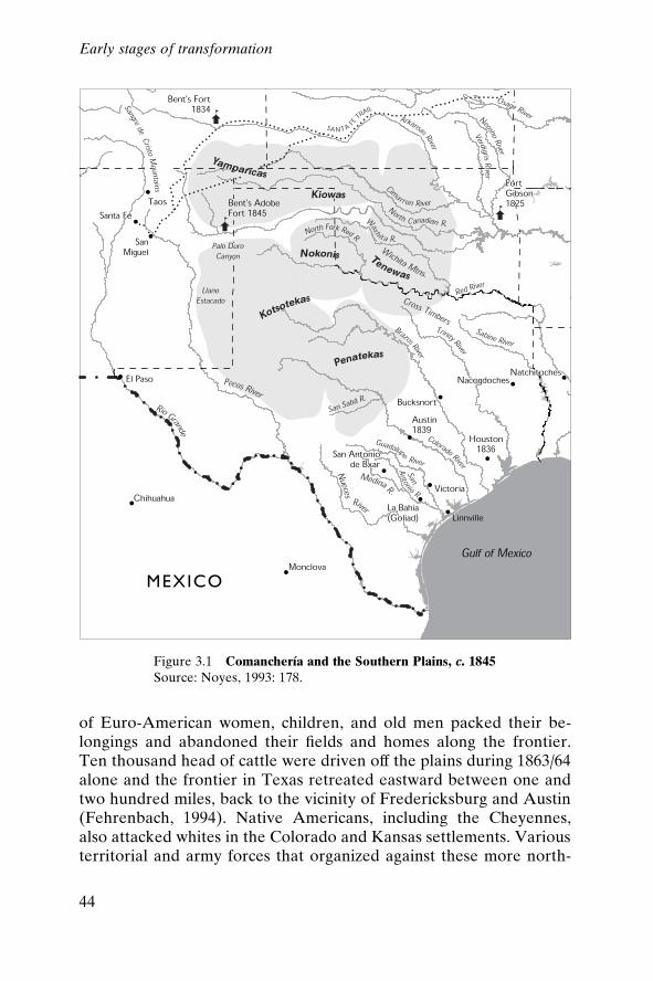
of Euro-American women, children, and old men packed their be-longings and abandoned their ®elds and homes along the frontier.Ten thousand head of cattle were driven off the plains during 1863/64alone and the frontier in Texas retreated eastward between one andtwo hundred miles, back to the vicinity of Fredericksburg and Austin(Fehrenbach, 1994). Native Americans, including the Cheyennes,also attacked whites in the Colorado and Kansas settlements. Variousterritorial and army forces that organized against these more north-
Figure 3.1 ComancherõÂa and the Southern Plains, c. 1845Source: Noyes, 1993: 178.
Early stages of transformation
44
ern peoples pushed many Comanches and Kiowas further south intoTexas.
When the Civil War ended, attention again turned to the troublesalong the frontier. In 1864, the federal government sent troops intoComancherõÂa ± mostly responding to increased Kiowa raiding alongthe Santa Fe Trail. After the end of the Civil War, the federal gov-ernment met with numerous representatives of several bands ofComanches, Kiowas, Cheyennes, and Arapahoes on the Little Arkan-sas River. As in the past, the Native Americans promised to stopraiding or attacking white settlements and the federal governmentpromised trade and protection of Indian Territory (which was grow-ing steadily smaller). For the Comanches, this meant most of thepresent-day Southern High Plains of Texas and western Oklahoma.In 1867, the federal government sent another peace commission tomeet with the same bands. The resultant agreement was the famousMedicine Lodge Treaty, by which the Comanches, except for theKotsotekas and Quahadas, agreed to renounce their claim to greaterComancherõÂa and to live upon a reservation of some 14,245 squarekilometres (about 5,500 square miles) in Indian Territory. Ten Bears,a Yamparika Comanche leader who spoke for the Penateka, Yam-parika, and Nokoni divisions, argued eloquently for his people to beleft alone (quoted in Fehrenbach, 1994: 474±5):
My people have never ®rst drawn a bow or ®red a gun against the whites.There has been trouble between us, and my young men have danced the wardance. But it was not begun by us. It was you who sent out the ®rst soldierand we who sent out the second . . . If the Texans had kept out of ourcountry, there might have been peace. But that which you now say we mustlive on is too small. The Texans have taken away the places where the grassgrew the thickest and the timber was the best. Had we kept that, we mighthave done the things you ask. But it is too late. The white man has thecountry which we loved, and we only wish to wander on the prairie until wedie.
The reservation, called the Leased District, established between the98th and 100th meridians, bounded on the north by the CanadianRiver and on the south by the Red, had been included in the originalterritory assigned the Choctaws and Chickasaws when they migratedunder the removal programme (Hagan, 1976: 16). This small cornerof Indian Territory did not include the better hunting lands in Texas,and so most of the Comanches continued to consider all of the landsouth of the Arkansas River theirs. Only a few bands agreed to move
Early stages of transformation
45
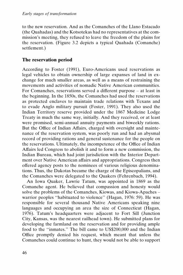
to the new reservation. And as the Comanches of the Llano Estacado(the Quahadas) and the Kotsotekas had no representatives at the com-mission's meeting, they refused to leave the freedom of the plains forthe reservation. (Figure 3.2 depicts a typical Quahada (Comanche)settlement.)
The reservation period
According to Foster (1991), Euro-Americans used reservations aslegal vehicles to obtain ownership of large expanses of land in ex-change for much smaller areas, as well as a means of restraining themovements and activities of nomadic Native American communities.For Comanches, reservations served a different purpose ± at least inthe beginning. In the 1850s, the Comanches had used the reservationsas protected enclaves to maintain trade relations with Texans andto evade Anglo military pursuit (Foster, 1991). They also used theIndian Territory reserve provided under the 1867 Medicine LodgeTreaty in much the same way, initially. And they received, or at leastwere promised, semi-annual annuity payments and biweekly rations.But the Of®ce of Indian Affairs, charged with oversight and mainte-nance of the reservation system, was poorly run and had an abysmalrecord of providing rations and general sustenance for the people onthe reservations. Ultimately, the incompetence of the Of®ce of IndianAffairs led Congress to abolish it and to form a new commission, theIndian Bureau, which had joint jurisdiction with the Interior Depart-ment over Native American affairs and appropriations. Congress thenoffered agency posts to the nominees of various religious denomina-tions. Thus, the Dakotas became the charge of the Episcopalians, andthe Comanches were delegated to the Quakers (Fehrenbach, 1994).
An Iowa Quaker, Lawrie Tatum, was appointed in 1869 as theComanche agent. He believed that compassion and honesty wouldsolve the problems of the Comanches, Kiowas, and Kiowa-Apaches ±warrior peoples ``habituated to violence'' (Hagan, 1976: 59). He wasresponsible for several thousand Native Americans speaking ninelanguages and occupying an area the size of Connecticut (Hagan,1976). Tatum's headquarters were adjacent to Fort Sill (JunctionCity, Kansas, was the nearest railhead town). He submitted plans fordeveloping the farmland on the reservation and for providing amplefood to the ``inmates.'' The bill came to US$200,000 and the IndianOf®ce promptly denied his request, which meant that unless theComanches could continue to hunt, they would not be able to support
Early stages of transformation
46
Figure 3.2 A typical Quahada settlementSource: History Study Pictures, Indians of History, Library of Congress Prints and Photographs Collection.
47
themselves. At this time, only a few Comanches were staying at theagency; life there offered no bene®ts over the nomadic life on theplains. And it had become obvious to the Comanches that makingtrouble gained them attention and food: ``the tribes that submittedmeekly to the whites and never broke treaties were allowed to starvein obscurity, forgotten on their reservations'' (Fehrenbach, 1994: 490).
Military intervention and retaliation escalated in the 1870s in re-sponse to increased raiding and attacks by Comanches (Hagan, 1976:71). At this point, some of the remaining Kiowas and Comanchesdedicated themselves to ®ghting to the bitter end. Kicking Bird pro-nounced that his ``heart was a stone; there was no soft spot in it'';Lone Wolf, a ®erce Kiowa raider, foretold: ``I know that war withWashington means the extinction of my people, but we are driven toit'' (Hagan, 1976: 99).
With all of the remaining Comanches on the reservation, this con-stituted, for the ®rst time in their history, a gathering of the entireComanche community. The surrender of the Quahadas on 2 June1875, marked the cessation of Comanche hostilities and the end oftheir existence as nomadic warriors dominating the southern plains(Hagan, 1976). There were fewer than 1,600 Comanches present(Hagan, 1976: 139).
On the reservation, government agents controlled the supply ofnearly all the economic resources Comanches depended on. Rationswere distributed at Fort Sill every two weeks or when available until1879, when the agency relocated to what is today Anadarko, Okla-homa. Winter buffalo hunts provided the Comanches with meat otherthan beef and brought income through the sale of hides. The last ofthese hunts occurred in the winter of 1878/79, when the Comancheswere unable to track any buffalo.
The buffalo
Buffalo were killed by the million on the Southern High Plains (Gard,1959). Slaughtered for the hide industry, the massive herds wererapidly depleted, proving that the animals were not after all ``innu-merable, boundless or in®nite'' (Worster, 1994: 66). (An approxima-tion of the enormous herds is depicted in ®gure 2.2, p. 34.) The buf-falo of the Texas plains, known as the Southern Herd, numbering inthe hundreds of thousands, were effectively exterminated in fouryears, from 1874 to 1878 (Pool, 1975). Some have suggested that thismindless slaughter was motivated by aims other than the obvious
Early stages of transformation
48
material gain realized from the very pro®table hide trade. The buf-falo, they argue, were emblematic of the old West, untamed andunusable by Anglo settlers. Buffalo foraging on the range would bereplaced by cattle ± the new West, as intended by some divine pur-pose (Doughty and Parmenter, 1989).
The attitude that the Llano was no more than the sum of its envi-ronmental resources, which could be put to better purpose by servingeconomic and agricultural interests than by supporting native speciesof animals and plants, was complemented by the belief that the vast-ness of Texas was matched by the inexhaustibility of the animals andbirds. The Treaty of Medicine Lodge (1867) did not prohibit whitesfrom hunting on the High Plains, but hunting parties had stayed awayuntil the early 1870s, perhaps daunted by the prospect of encounterswith armed and mounted Comanches.1 With that threat largelyeliminated by the US military's intervention, hunting parties, orga-nized around the aim of bagging as many game animals as possible,began to travel regularly through the Texas plains in the late 1800sand early 1900s in search of buffalo, antelope, deer, wolves, evenprairie dogs (Doughty and Parmenter, 1989). Birds were also fav-oured targets, both for the sport and for the feathers and meat.2 Oneresearcher has concluded that the death toll for animals and birds onthe plains alone during the years from the 1870s through the earlypart of this century numbered around 500 million (B. Lopez, quotedin Worster, 1994).
Worster (1994) contends that killing on such a staggering scale wasthe inevitable result of the philosophical separation of the animals ofthe plains from the total ecology of the plains. Animals were notregarded as an integral part of the region, creatures who should beallowed to live on unmolested in their habitats, exploiting and sup-porting the ecological system surrounding them. Instead, animalswere seen as foraging on grasses where cattle should properly begrazing, or attacking valuable range animals, or being less useful thanmore familiar animals brought with the European settlers from theirformer homes (Worster, 1994). As a result, animals and birds werepursued with an unprecedented and probably unmatched ferocity,both by individual hunters and bounty-hunters and by those carryingout the mandates of government policies.3
When government rations were not adjusted to compensate for theirreplaceable loss of the buffalo, the Comanches tried raising cattlethat they obtained from the agents and through their own efforts.Cattle trails between Texas and Kansas went across reservation land,
Early stages of transformation
49
and Comanches enforced their legal ownership of the reservation bycollecting tolls on the herds that crossed their land (Hagan, 1976).Comanches captured strays and as late as the 1890s were known toraid neighbouring Chickasaw herds. They earned ``grass money'' byleasing their pastures to Texas ranchers beginning in 1885. Thisarrangement lasted until 1906 and provided each Comanche witha semi-annual payment. The periodic disbursement of grass moneyattracted a number of licensed Anglo traders to the reservation andalso fuelled Comanche gambling activities. They still had not becomeself-supporting by the end of the reservation period in 1901.
Reservation life successfully broke up the larger residence bands.An even more signi®cant change in Comanche social and economicrelations was engineered by the number of white settlers who pouredinto the area after allotment. In 1878, only 150 to 170 whites residedon the reservation, typically agency personnel and licensed tradersand suppliers. By 1890, trespassers were a persistent problem. In theeleven years leading up to allotment (see chapter 4), they becamemore numerous and more dif®cult to control, and by the end of thereservation period, Anglos were illegally ¯ooding onto the reser-vation in anticipation of its opening to homesteading. When theremaining reservation lands were assigned by lottery, the nearly 1,500Comanches found themselves in the midst of more than 30,000 Anglohomesteaders (Hagan, 1976: 269).
The destruction or marginalization of the Native Americans in theregion has been variously interpreted. Notably, recent authors, espe-cially those who have interviewed Comanche and Kiowa descen-dants, argue that the people saw their loss as understandable withinthe context of their history. They displaced the Apaches before them,thus they were displaced by the Europeans. Yet there is a certainbitterness about the way, it was done, through treaties and warfare.To Fehrenbach's mind (1994: 371), the treaty process was a sham:
Few, if any, of the signatories could read the texts of treaties, or even signthem ± they gave assent by touching the pen with which the whites signed ±and they assented to loose translations. Often, neither party understood theexact territorial de®nitions or proposed boundaries; American commis-sioners frequently set boundaries that were never surveyed. Almost all thePlains tribes had the same social and political organization as the Com-anches; this meant that every adult warrior must touch the pen before atreaty became binding upon an entire band or tribe. No treaty ever signedwith any tribe upon the plains was ever completely valid, from this factalone ± which every American commissioner refused to recognize. This
Early stages of transformation
50
rendered effective diplomacy with the warrior tribes almost impossible, ifnot ridiculous. American agents described Cheyenne, Dakota, and Com-anche ``nations'' as determinedly as did the Spanish scribes.
The Comanches did not like to attend councils; tribesmen wouldspeak their minds and the Anglos would proceed as if they had notheard them. They also did not like to attend councils to which theirenemies were also invited: ``Americans rarely understood why it wasunthinkable for Comanches and Apaches to sit together'' (Fehren-bach, 1994: 372). Owing in part to these grave indignities, Fehrenbachargues (ibid.), American diplomacy with the Native Americans wasmore reprehensible than the brutalities in¯icted upon them.
Massacre matched massacre; tortures were repaid in displacements andexterminations. The same forces that impelled the modern European na-tions to world power made the conquest of the American continent inevita-ble. From the late eighteenth century, most intelligent Europeans under-stood that the white entry into the Americas spelled at least a cultural deathwarrant for the natives. . . . The question facing the United States throughoutits advance across the land was never whether the aborigines should beremoved as a barrier to its civilization, but only the best means and time-table of the removal. The question was bound up in politics, ethics, morality,and even sentimentality ± but it was handled almost throughout with per-vasive hypocrisy.
But Foster (1991) argues that there is an important difference in theperspectives of Anglos and Comanches on Comanche history. Forexample, whites tell the story of the last buffalo hunt with nostalgiaand sadness. They saw the native identity as slipping away, almostlost. In contrast, the Comanches tell the story without regret or ®nal-ity. The story simply tells of an event that happened in the Comanchecommunity at some time in the past. In Anglo representations ofNative American peoples,
too often the activity is emphasized over the people who participated in it.Comanches, however, have not forgotten that the maintenance of a tra-ditional community depends on people, not on a ®xed set of behaviors,syntactic structures, or food sources. We have largely overlooked theComanches who surrounded and killed that last, disoriented bison and thenwent on with their lives. Those lives continued, bison or no, as did theComanche community they shared. At the time of the last bison hunt (per-haps sometime in the early 1880s) Comanches already were participating inpublic gatherings of their community different from those of ®ve or ten yearsbefore. They were getting on with the business of what they still talk aboutas ``being Comanche.'' (Foster, 1991: 2±3)
Early stages of transformation
51
Foster continues (1991: 167), ``It has even been asserted that theircommunity ceased to exist once the landscape in which we ®rstencountered them was remade in a European image.''
The assertion that the Comanche community ceased to exist oncethe landscape was changed is quite remarkable within the context ofwhat we mean by critical ecological zones or sustainable develop-ment. These were people who completely lost or were forced off theirlands and out of their mode of production. Culturally, they have sur-vived, with signi®cant government help. Certainly, the destruction ofthe buffalo by the white hunters providing hides for the market, aswell as by the Native Americans themselves, would have created acritical ecological zone. Perhaps a small change in climate did exac-erbate the decline of the great herds; the most powerful source ofchange, though, was human action undertaken to meet marketdemands, make money, take land ± the same forces that motivateactions by the current populations of the Llano. If there is a lesson tobe learned, it is perhaps this: losing control of the land, and one of itsprimary resources, the buffalo, completely transformed the lives andlivelihoods of the Native Americans on the Southern High Plains.Their communities ceased to exist in practical terms once the landwas no longer theirs to roam and the buffalo were brought to theedge of extinction. How different will the outcome be for thedescendants of the Euro-American settlers even more dependent onwhat the land can produce and the water can make possible?
Euro-Americans on the Llano
Ranching
With the forcibly decreased presence of the Comanches, the physicalenvironment slowly began to change as a result of Euro-Americansettlers' hesitant approaches into the region. The dominant mid-nineteenth-century Anglo presence on the plains, though, revolvedaround ranching. Settlers attempting to move onto the plains oftenfound their claims already leased to the big ranching enterprises: thelargest of these was the XIT Ranch at 1,215,000 hectares (threemillion acres). Ranching grew out of the herding practices of theComanches and Mexicans after Texan independence. Limited beforethe Civil War to the area bordered by Mexico, the Gulf of Mexico,the Nueces River valley, and the Edwards Plateau, ranching ex-panded north to the High Plains after the Civil War ended (Webb,
Early stages of transformation
52
1931). With the southern states economically devastated, ranchersbegan to look toward the growing markets for meat and hides in thenorthern states, and began driving the herds closer to those markets.Within 15 years, and for the decade following that expansion, cattleranching dominated the plains. The post±Civil War economic boomrapidly integrated the frontier West into the US economy. Respond-ing to the high prices and high demand for beef from Midwestern andEastern markets, Texas cattle numbers nearly doubled in 16 years,from fewer than 5 million cattle in 1875 to more than 9.8 million in1891, an inventory peak that would not be exceeded until 1945(Texas Department of Agriculture, 1990: 5).
The boom
Colonel Charles Goodnight, thought to be the ®rst rancher on theSouthern High Plains, brought cattle from Colorado in 1877 andestablished the ja Ranch in what is now Deaf Smith county. By 1883,between 25 and 30 ranches were operating in the northern part ofthe Llano (Sheffy, 1963: 13), including enormous ranches owned byMidwestern and British interests. The Capitol Freehold Ranch, orCapitol Syndicate Ranch (XIT), was formed in 1881 when the TexasState legislature created a 1,215,00-hectare (three-million-acre) res-ervation in nine counties in Panhandle/Plains Texas (Dallam, Hart-ley, Oldham, Deaf Smith, Parmer, Castro, Bailey, Lamb, and Hock-ley). This land grant was used as payment for the construction of anew capitol building in Austin. A group of Chicago businessmen wonthe bid, built the capitol, and stocked the ranch with over 160,000head of south Texas cattle. The Matador Land and Cattle Companywas probably the second largest ranching operation on the HighPlains. The company, ®nanced by Scottish investors, purchasednearly 220,000 hectares (540,000 acres) on the Southern High Plainsand leased another 81,000 hectares (about 200,000 acres) during the1880s.
Although these companies purchased (or traded for) their landtracts, until the early 1880s, most ranchers simply used the free rangeto stock cattle. Texas, as part of its agreement to join the UnitedStates in 1845, maintained public lands, and permitted ranchers touse public domain lands as open range for cattle ranching. Known asrange rights, this gave ranchers authority to use the surroundingrange and its water without cost (Webb, 1931). Within only a fewyears, however, greater numbers of homesteaders and cattle on the
Early stages of transformation
53

range meant that competition for land increased, and establishingtenure became necessary. During the early 1880s, ranchers beganfencing in their land (and public land they did not own) with barbedwire, sometimes encircling homesteaders (Dale, 1930). By 1883,competition for land between ranchers and homesteaders was so®erce that the Texas legislature had to step in to settle land disputes.Free-range ranching quickly came to an end when most public andschool lands were sold and private land was fenced. Fencing was usednot only to establish rights to land, but is credited with improvingranching by lowering operating costs, improving the quality of cattle,particularly through controlled breeding, and with settling unwateredportions of the Southern High Plains (Dale, 1930). The availability ofcheap, practical, barbed-wire fencing ``revolutionized ranching [but]it did not destroy it and would not have threatened it seriously had itnot been for its [bene®cial] effects on the farmer's frontier'' (Webb,1931: 316).
The number of Texas cattle continued to increase through the1870s and 1880s and exceeded 9 million head by 1888. Until 1890,most cattle were sent to market through trailing. A series of cattletrails crossed the Great Plains leading to ``cowtowns,'' particularly inKansas (such as Abilene and Dodge City), where cattle were sold andshipped to Kansas City, St Louis, and Chicago for slaughter or ®n-ishing. Most Texas ranchers hired drovers, or trailing contractors, todrive their cattle northward to the Kansas cowtowns (Skaggs, 1973).Through the 1870s and 1880s, cattle trailing to Kansas was lessexpensive than paying rail freight charges (Skaggs, 1973). About amillion head per year were trailed from Texas to northern marketsduring the 1870s and 1880s (Dale, 1930). Most Texas ranchers drovetheir cattle either north-west across the Pecos Trail (the Goodnight±Loving Trail), which led from San Angelo to Santa Fe, or northacross the Chisholm, Matamoros, and Western trails. North-westTexas and Southern High Plains ranchers drove their cattle along thePotter±Bacon Trail, which crossed the High Plains and joined theSanta Fe railroad in south-east Colorado.
The bust
Trailing was short-lived: the extension of railroads, fencing that brokeup the open range, and quarantines to contain Texas fever in the1880s led to its demise. Texas fever is a cattle disease caused by amicroscopic parasite that uses ticks as its vector. Texas Longhorns in
Early stages of transformation
54
south Texas developed immunity to the disease, but thousands ofcattle of other breeds died wherever Longhorns were trailed. Asearly as 1882, High Plains ranchers, led by Charles Goodnight, postedarmed men on the Potter±Bacon trail to stop the trailing of southTexas Longhorns across the High Plains (Skaggs, 1973). Kansasreacted even more strongly in 1884 by forbidding the entrance ofsouth Texas cattle into the state except during the winter months,when cattle were not killed by the disease. Quarantines movedTexans to call for a national trail to be built and maintained bythe federal government, but few other constituencies supportedthe effort. The end of trailing ®nally came in 1889, when the Secre-tary of Agriculture, J.M. Rusk, quarantined all or parts of 15 south-ern states. Texans were forced to patronize railroads. Ironically, itwas soon after the 1880s quarantines that government researchers atthe US Department of Agriculture discovered the cause of Texas fe-ver and showed that it could be eradicated by dipping cattle in acleansing solution that killed the disease-bearing ticks (Skaggs, 1973).By this time, however, the trails were closing, and few lasted past1890. Railroads had extended even to the High Plains; a line con-necting Fort Worth and Denver was operational by 1890 (Dale,1973).
While the quarantines on Texas cattle dampened the cattle indus-try boom somewhat for ranchers on the Southern High Plains, it wasa disastrous coincidence of environmental and economic conditionsthat led to the complete collapse of the cattle trade in the late 1880s.Ominously foreshadowing the coming Dust Bowl calamity by roughly50 years, the booming cattle ranching on the Plains soon began tohave serious impacts on the rangelands. Overstocking the range wasleading to heavily overgrazed land. The range was viewed as an end-less supply of free grass, and more and more cattle were brought ontoit; there were 7.5 million head on the Great Plains by the mid-1880s(White, 1991: 223). With unusually mild winters, these growing num-bers of cattle were surviving, and increasing grazing pressure on therange each subsequent season. The most heavily grazed grasses soondeclined and hardier, woodier plants gained dominance. But theseplants were much less edible, and with the return of very harshweather in the winter of 1885 the poorly fed cattle could not survive.On the Southern High Plains, before the worst overgrazing wasoccurring, one steer could thrive on ®ve acres (2 hectares) of range-land; by 1880, it took 50 acres (20 hectares) (White, 1991). The onsetof freezing temperatures and high winds in 1885, combined with the
Early stages of transformation
55
loss of range due to overgrazing, brought heavy losses. The herds onthe Southern High Plains were decimated.
The Northern High Plains underwent the same disastrous con-ditions the following year, and the combined losses contributed to theworsening economic scene. A national depression was deepening,and nervous creditors, made more concerned by the cattle losses,soon began calling in their loans. To satisfy debts, ranchers beganselling off their herds, driving prices down even further. Rancherswho could moved further west to the deceptively sparse grasslands ofthe Great Basin and the intermontane west. The cattle ranching thatremained on the plains was just a remnant of the ¯ourishing cattletrade of the late 1870s and early 1880s, never to recapture the teem-ing numbers of that era.
Settlement
At the same time as the ranching expansion on the plains, severalattempts were being made by emigrants to the plains to establishfarms and communities. These early attempts, in the 1870s, werefounded along the breaks, off the eastern edge of the Caprock, belowthe plains in the small canyons and headlands of the few smallstreams. Access to water was the most important factor in locating afarm, and surface water was very scarce up on the Llano. The ®rstfarming settlement established on the Llano, the town of Estacado,was started in 1878 by a community of Quakers from Indiana. Of thefour families who moved to the new town of Estacado that year, onlyone remained after the ®rst winter. Paris Cox and his family planted avariety of crops the following spring and saw good harvests. The newsof good weather and yields enticed other members of the Indianagroup out to the plains and within ten years there were 23 farmsaround Estacado (Green, 1973).
The arrival of the railroads and the coincidence of cyclically drivenfavourable weather conditions increased the movement to the plainsin the last two decades of the nineteenth century. When the harshclimate and drought forced people off the plains, railroads and newsof good rainfall and harvests brought them back in droves. Clearly,people wanted to believe that the plains could be made habitable andeven prosperous. Vast amounts of land were available and the hopethat these were good arable lands was being made reality by the willthat they would be in the near future.
Settlers poured onto the plains in large numbers in the early 1880s.
Early stages of transformation
56
Reconstructed climatic data show that the weather was highly vari-able throughout that decade, with more rainfall than was typical forthe region for several years in a row (Lawson and Stockton, 1981).But the latter half of the 1880s brought a turn toward much drierthan normal weather, and farmers began pulling up stakes and aban-doning homesteads as crops failed again and again. Dust stormsblew up in the spring of 1889 and raged for days. By 1891, the plainswere rapidly depopulating. In Floyd County, for example, therewere 176 farms at the beginning of 1891. By the end of 1892, ®fty-®ve farms remained. Farmers also began sinking into debt as theysought mortgages to make up for the loss of crop income (Green,1973).
Legislation, railroads, and boosterism
The further transformation of the Llano was under way. The extremehardships of homesteading notwithstanding, people still arrived onthe plains to stake claims. Several interests were at work promotingthe transformation of the plains into farming communities. The mostprominent of these were the federal government, acting throughfederal land laws (which in turn in¯uenced the state land laws), therailroad companies, and the individual boosters and promoters of thenascent towns of the plains.
Legislation
Land laws were an early impediment to successful farming on theplains, although the intent of the laws was always to promote settle-ment. In distributing the public domain, the federal governmentdevised land laws directly aimed at promoting a certain type of set-tlement and development. The original land distribution scheme, theLand Ordinance of 1785, provided for large tracts of land 9,654metres by 9,654 metres (six miles by six miles). These tracts werethen subdivided into sections measuring 1,609 metres (one mile) to aside, which were in turn again divided into four quarter-sections andthen sold. Small landholders would best represent the sort of nation-building envisioned by the founding fathers, it was believed. Numer-ous small tracts of land farmed by individual families promoted theideals of independence and self-suf®ciency so embedded in the notionof Americanism.
The reality of land distribution fell far short of these lofty goals. To
Early stages of transformation
57
fund public works, the cash-poor federal government began issuingland scrip that could be bought and sold. This led to land speculationand the amassing of large holdings by purchasers with no intent tosettle on those lands (White, 1991). What White refers to as extra-legal means to acquire land were in fact adjustments to the federalland distribution system necessitated by Major Powell's ``fact of arid-ity.'' It soon became obvious that roughly 65 hectares (160 acres), aquarter section, of semi-arid plains could not support a farmer, letalone a farmer and a family: ``without irrigation . . . [the] quarter-section farm . . . was not a ticket to independence but to starvation''(White, 1991: 142±3). The land laws that settled the eastern wood-lands and the prairies would not lead to permanent settlement of thesemi-arid, and often arid, plains. In response the federal government,unwilling to change the land distribution system, moved to changethe climate.
Congress legislated the Timber Culture Act (1873), which wasintended to foster the growth of trees on the plains, grounded in thepopular theory that rain would increase in areas where the trees wereplanted and the sod broken up and ploughed (White, 1991). Whenthe climate did not respond, Congress then passed the Desert LandAct (1876) allowing settlers to acquire a full section (256 hectares or640 acres), with the provision that the land be brought under irriga-tion within three years of ®ling a claim to the land. However, inregions of negligible surface water, three years was scarcely a rea-sonable deadline to ``prove up'' a claim.
In the midst of these developments in the schemes to settle theplains, John Wesley Powell issued his Report on the lands of the aridregions of the United States (Powell, 1879). Recognizing the necessityof access to water for survival on the semi-arid plains ± 508 milli-metres (20 inches) of rainfall annually was seen as the minimumrequired for self-sustaining agriculture ± Powell created a plan forallocating the lands beyond the 100th meridian, the geographic de-marcation of sustainable agriculture (Powell, 1879). The basicframework of the plan entailed creating ``hydrographic basins'', unitsof land centred around their relation to available water (Powell,1890). While Powell clearly did not comprehend the availability ofthe extensive stores of water underground, or foresee how access tothat water could make much of the arid lands irrigable, he clearly didunderstand that, given semi-arid to arid conditions, ``values inhere inthe water, not in land; the land without the water is without value''
Early stages of transformation
58

(Powell, 1890). Therefore, Powell's scheme called for the inclusion ofaccess to water in all land grants, attaching water rights to the land,creating irrigation and pasturage districts, with cooperatives insti-tuted to manage irrigation systems and rangelands (White, 1991).
Powell's plan was rejected by the US Congress, which chose tocontinue pursuing individual land grants. Attempts to modify landdistribution were a de facto acknowledgment that land laws neededto be different in the semi-arid and arid lands, but actual restructuringof land laws to re¯ect the climatic reality of the West seemed un-likely. Law must follow custom, Powell advised, where existing lawdoes not address the physical reality (Powell, 1890). In Texas, whereland distribution schemes had their beginnings in the early days ofMexican control, landholdings were structured to accommodate thearid and semi-arid climate. The large holdings amassed by ranchersre¯ected this Mexican in¯uence, overriding the federal tendency tolimit individuals' ability to own too much land. Texas did not insti-tute any form of homestead act; only a relatively small percentage ofland was ever given away, and that chie¯y for the purposes ofbuilding schools, with some land going to veterans, immigrants, andthe railroads. A total of about 21 million hectares (52 million acres)was provided for schools, nearly a third of the land area of thestate (Webb, 1931). Most of the agricultural land in the state hadbeen distributed by 1880 (climate notwithstanding); what remainedwas largely without access to surface water. A scheme was devisedand legislated providing that the land be classi®ed as agricultural,grazing, or woodland. Grazing land was further divided into wateredor dry land. Homesteaders could then apply for a single section ofagricultural land, two sections of grazing land, or a single section ofeach.
Although this system acknowledged the dif®culty of maintaining aliving in the semi-arid and arid parts of the state, like the Llano, thelaw was still amended almost annually to allow settlers to obtain everlarger tracts of land, particularly unwatered land. By the early yearsof the twentieth century, settlers in the Llano were eligible for hold-ings of up to 2,048 hectares (5,120 acres), eight sections of land(Webb, 1931). Thus the Texas laws, despite starting from a positionthat recognized the near-impossibility of surviving on the standardquarter-section of the humid prairies and eastern lands, also evolvedto accommodate the unforgiving climate of the Llano and other partsof the state.
Early stages of transformation
59
Railroads
A second major force behind the settlement of the plains was therailroads. If it had been at all possible for the railroads to haveinduced more rain to fall on the plains, the railroad companies wouldhave ensured it. As it was, railroad companies were avid promoters ofsettlement on the plains. They planned to build lines in advance ofsettlement, to reap the pro®ts of ¯ourishing markets, should theyarise. Therefore, the railroad builders were determined to do every-thing possible to ensure that settlement would occur. Towns alongthe lines were necessary to supply the engines with fuel and water,and to ®ll the freight cars with goods, farm products, and cattle.
Railroad companies began promotional campaigns to lure settlersto the plains: they published brochures, magazines and pamphletsextolling the virtues of the region, hired agricultural and migrationspecialists, held fairs, and ran demonstration and model farms(Blodgett, 1988). Speci®c regions or types of agriculture were fea-tured in brochures such as the Fort Worth and Denver City RailroadCompany's booklet on Texas ``with Special Information Concerningthe Panhandle,'' ``The Panhandle and South Plains of Texas,'' pub-lished by the Atchison, Topeka and Santa Fe Railroad Company,``Farmers Make Good in the Panhandle and South Plains,'' from theSanta Fe Company, and the Rock Island Line's brochure entitled``Panhandle Country for Beef Cattle and Dairy Farming'' (Blodgett,1988).
The railroad companies published testimonials as to the greatvariety of agriculture that could be practised on the plains as well asvarious attestations to the success of farmers already in the region.For credibility, however, the railroads also recognized the importanceof addressing the issue of rainfall directly. Perhaps in the interests ofhonesty, much, though by no means all, of the promotional literatureturned away from the standard propaganda on how the rails or steelploughs increased rainfall, or how increasing population increasedrainfall; they instead focused attention on the great potential in dry-land farming and irrigation (Blodgett, 1988).
Additionally, railroad companies' brochures, in which actual USWeather Bureau precipitation tables were reprinted, always includedstatements from experts con®rming that the timing of rainfall wasactually more important than the amount. Therefore, although farm-ers from more humid regions might look askance at rainfall averagesof 355±500 millimetres (14 to less than 20 inches) annually, they were
Early stages of transformation
60
to be reassured that the rains fell reliably when needed ± in the winterand early spring for good planting conditions and then again duringthe growing season, to promote high yields and abundant harvests(Blodgett, 1988). The railroads' record in expanding settlement onthe plains was at best mixed. Maps of planned railroad lines from the1870s and 1880s were far more optimistic than what was ultimatelybuilt. Today, the Llano is served chie¯y by freight lines with verylimited passenger rail service.
Boosterism
Boosterism, the third major force for settlement on the Llano, ispromotion of a place through paid advertising in the form of book-lets, pamphlets, postcards, and in at least one notable instance, amotion picture. Two basic approaches were used: ®rst, that the cli-mate was actually very favourable to agriculture, with the correctadaptations and technological advances; second, that the plains werethe future, a healthful, industrious place to relocate, raise families,and found prosperous communities.
The ®rst approach, misrepresenting the unpredictable climate andthe cyclical drought, had been a mainstay of the railroad companies'advertising. But the boosters took it far beyond that. An entire sub-industry emerged in the late 1800s to contradict eyewitnesses'accounts of their failed experiences on the plains. Whole publicationsappeared, dedicated to the premise that irrigation would soon turnsemi-arid lands into bountiful farms. Irrigation Age, started by theeditor of the Omaha Bee, William E. Smythe, was foremost amongthem. ``The Greatest Irrigated Farm in the World'' (illustrated),``Remarkable Growths Under Irrigation,'' and ``Prosperity in Irriga-tion'' are the titles of a few representative articles published in theIrrigation Age in the early 1890s (Irrigation Age, 1891±1893). A tire-less promoter, Smythe crusaded throughout the western states, lec-turing and hosting congresses on the possibilities of irrigated agricul-ture. Smythe would later, in 1911, write a book extolling the changesbrought about by irrigation, optimistically titled The conquest of aridAmerica.
The dif®culty in gaining access to water to irrigate with was notaddressed in the promotional literature of the late 1800s. Shallowgroundwater could be reached by windmill-driven pumps but couldbe quickly tapped out; what was necessary for agriculture was simplymore rainfall. Numerous books were written on the scienti®c ad-
Early stages of transformation
61
vances that proved how amenable the region really was to climaticchange ± how the incomparably rich soils of the plains needed only tobe broken up to begin soaking up available moisture like a sponge.``Rainfall follows the plough'' was a popular motto, shorthand for ascienti®c theory of the power of steel ploughs to attract rainfall(Smythe, 1911). Even the advance of the railroads was purported toincrease rainfall (American News Co., 1874).
With the realization that drought was as likely as normal rainfall(and frequently more likely), new interest was generated in so-calleddryland farming. The promise of dryland farming was touted as thenew way to institute agriculture permanently on the plains. J.A.Widtsoe described (and promoted) techniques recommended by theself-proclaimed evangelist of dryland farming, H.W. Campbell, in his1911 treatise on the subject (Widtsoe, 1911). These techniques rec-ognized the importance of retaining as much soil moisture as possi-ble. But Campbell also preached deep-ploughing of ®elds, compact-ing subsoils and loosening topsoils through the windy summer andwinter months. The adoption of this method inevitably led to severewind erosion in dry years (Kraenzel, 1955). But in wetter years, asthe latter half of the 1890s were, the increased rainfall and the dry-farming methods led to an era of great prosperity on the plains. Thiswas clearly the most effective boosterism of all.
A secondary theme of the promotional campaign to populate theplains with farmers and town builders centred on the healthy envi-ronment and the limitless potential for wealth and success. Thesemessages had strong allure for Europeans, easterners trapped incramped cities, and for farmers feeling crowded on the prairies.Blodgett (1988: 86) describes the phenomenon:
The work of the railways and promoters was signi®cantly enhanced by thecontinuing demand of restless America for new lands, especially agriculturallands. . . . [T]hese lands held special attractions for those in search of newand cheaper farms, for those in need of healthier climates, for ethnic andreligious groups seeking new communities, and for individuals desiring newhomes and opportunities.
With increasing settlement and coincident favourable weather, landprices began to rise from US$10 to $30 per 0.4 hectare (about oneacre) in the 1880s to $80 to $125 per 0.4 hectare in the 1890s (Blod-gett, 1988). Even this was useful to the boosters ± here was evidenceof how valuable the land actually was, and how it gained in value withsettlement. And, the message became, one had better act fast, before
Early stages of transformation
62
the land on the Llano was as expensive as the prairie lands. Landagents, having learned the lessons of the drought-driven exodus, alsowere seeking prosperous buyers who would not move away, leavingmortgages and debt behind them. Thus, land agents began promotingthe potential to improve upon one's situation, to start again in a placewhere a family could have an in¯uence on the kind of community itwould live amongst. Numbers of churches, schools, and the lack ofsaloons and depravities were underscored. Agents sent photographsback east of ``healthy children, tree-and-¯ower encircled homes, andif possible, prosperous-looking businesses and church buildings''(Blodgett, 1988: 89). The Industrial Survey of the city and county ofLubbock, compiled by the Lubbock Chamber of Commerce, includedthis promise in its introduction:
Any prospective settler coming to Lubbock and upon arrival here ®ndingthe average conditions different from those shown herein will be refundedtotal expenses to and from Lubbock. This guarantee is given by reason ofour desire to present only the true circumstances surrounding our city andcounty (Lubbock Chamber of Commerce, 1915: 1).
Those circumstances included ample provision ``with the greatest ofall necessities ± water,'' with approximately 70 per cent of the pur-ported 24 inches [600 mm] of annual rainfall coming during thegrowing season'' (Lubbock Chamber of Commerce, 1915). Again, thetiming of rainfall was emphasized to allay the concerns of easternfarmers: ``This amount of rainfall is . . . equal to 35 to 40 inches [890±1,000 mm] of rainfall annually in a rolling tight land country'' (Lub-bock Chamber of Commerce, 1915).
Not only was there reported to be an inexhaustible shallow watersupply of ``soft and clear water'' and ``rich chocolate loam'' waiting``in perfect readiness the coming of the man with the plow and thehoe,'' but this was a ``country of life giving sunshine and pure airand water, where natural conditions tend to favor and prolong life''(Dillard-Powell Land Co., 1908/1909). East Texans, the targetedaudience for this particular booklet, would experience a new ease ofliving in an extremely healthy climate with pleasant and mild con-ditions (Dillard-Powell Land Co., 1908/1909). Another booklet, dis-tributed by the nascent Lubbock County Chamber of Commerce,focused on the purity and healthfulness of the air, water, climate, andregion in general (Lubbock Commercial Club, 1909). Also note-worthy was the ease of making a pro®t with agriculture and ranching.A popular feature of most booster literature were the testimonials
Early stages of transformation
63
of people who arrived on the plains poor and soon became wealthybeyond their wildest dreams.
Conclusion
A picture emerges of the people who migrated to the Southern HighPlains. There was the population targeted by the more re®ned effortsof boosters, for one example: these were the conservative families,already successful farmers, who knew what they wanted in theircommunities, the kind of people they wanted as neighbours. ``Comeand get a home among people who are liberal hospitable charitablelaw-abiding, and where peace and harmony abound . . .'' (Dillard-Powell Land Co., 1908/1909). The authors frequently added, ``andwhite.'' Race was not subtly addressed: several tracts referred to theabsence of African-Americans on the south plains and the ``bene®ts''to be derived from this (Dillard-Powell Land Co., 1908/1909)). Studiesof the racial makeup of the western states found similar ``enclave-ment'': African-Americans, Chinese, Hispanics all were attracted tospeci®c areas, separated from the larger Anglo settlements (Deutsch,1992).
With the Native Americans contained and off the plains, settlersattempted to farm the Llano. The vagaries of the climate were soonrevealed, as drought and severe winters forced people off the Llano.Boosters promoting the region spoke to certain traits in settlers:individualism, self-reliance, stubbornness, and optimism. While itprobably did not require extraordinary vision to see wheat wheregrass was growing, it did require some fortitude to keep that visionthrough years of drought, wind, broiling summers, and harsh winters.Perhaps because there was so little ``new'' land left to claim in theWest, people became determined to build homes here on the Llano.There really was no place left to go to begin again. And, for that ®rstgeneration of pioneering farmers who stayed on the plains, therewards were just a few short years away.
Notes
1. Rathjen (1973, 155) notes that there was much confusion over the MedicineLodge Treaty. He doubts that Native Americans were aware that the treaty didnot explicitly prohibit white hunting and did not obligate the US army to preventwhite intrusion. Since Comanche leaders argued publicly that the High Plainsshould not be hunted by whites, it is doubtful that leaders willingly and knowinglysigned over rights to the land. The leader of the ®rst large hunting party, J. Wright
Early stages of transformation
64
Mooar, was also confused over the status of the High Plains, and went, in 1873, tothe commanding of®cer at Fort Dodge to seek permission to hunt on the HighPlains. The commander could not prevent the hunting party from entering theHigh Plains.
2. These outings were often sponsored by the wildlife agents in the region, re¯ectingthe vision, most government of®cials held regarding their charges. The earlieststate of®ce for conservation in Texas, that of Fish Commissioner, held its missionto be the introduction of carp into Texas rivers and lakes (Doughty and Par-menter, 1989). The National Audubon Society pushed the state to legislate the®rst protective measures for birds in 1903, and with growing awareness of theongoing extirpation of several species, a game agency was added to the Fish andOyster Commission, so renamed after its reorganization in 1895 (Doughty andParmenter, 1989).
The aim of this agency, however, was the preservation of game for hunting.Not until the 1920s did the agency move to regulate hunting by requiring licensesand bag limits for hunters in Texas. The state even began to move towardrestocking species (deer, antelope, and turkeys, at ®rst) in regions where they hadbeen extirpated (Doughty and Parmenter, 1989). These efforts, albeit aimed atpreserving hunting in Texas, at least signalled an awareness that conditions wereirrevocably changing, and that the resources of the Llano, and the rest of theWest, were indeed exhaustible.
3. Other species considerably less dangerous to stock were also targeted, includingcoyotes and prairie dogs (Cynomys ludovicionus) ± the latter because of the beliefthat their burrows could be responsible for broken fetlocks and falls for horsesand range animals. Brought to the brink of extinction on the plains by extensivepoisoning programmes, prairie dog populations have rebounded slightly, andalong with other species that have been reintroduced to the plains, are no longerthe target of extermination programmes. This was due in part to a growingawareness in the 1960s of the reckless approach to wildlife in the United States. In1966, the Endangered Species Act was passed, and then updated and strength-ened in 1973 and again in more recent years. It is clear, however, that some ani-mals are truly extinct and others so attenuated that they may also disappear; thedisappearance of any semblance of the original, seemingly inexhaustible com-munities of animals and birds attests to the sweeping in¯uence of Anglo settle-ment on the Llano.
Early stages of transformation
65
4
The new century and thenew ecology of the Llano:1900 to 1945
Replacement
The beginning of the twentieth century was the start of a new era onthe Llano. A fortuitous turn of wetter than normal weather, a grow-ing trend toward mechanization, and motorized farm equipment wereinducing settlers to farm larger and larger tracts of land. And with theComanches all but removed from their lands, particularly after theallotment or privatization of the reservations, the Anglo-Europeansettlers had only to prove up their claims to realize boosters' prom-ises of pro®table and prosperous farms. All the success of the ®rstfew decades of the twentieth century obscured the subtle signs of thedisaster to come, however, as fragile lands, uncertain markets, andunpredictable weather combined to undo the new ecology of theLlano. The ecological transformation of the Llano, begun in the fewpreceding decades, was now accelerating.
The Llano Estacado was one of the last regions of the contermi-nous United States to be populated by Anglo settlers. Emigrantsfrom the east and the more settled Midwest passed through the semi-arid and subhumid shortgrass prairies on their way west; there waslittle in the forbidding and sere landscape to capture the imagination.The ¯at featureless Llano contrasted greatly with the rolling plains of
66
Iowa and Missouri and eastern Nebraska and Kansas, cut throughwith rivers and streams. The lack of timber to clear was an asset tosome, but the fearsome reputation of the Comanches and the absenceof surface water were clearly reasons to keep going.
Surely one major reason why settlers ignored the potential of thehigh plains grasslands was the general belief, promoted throughschool books and popular gazetteers, in the existence of a GreatAmerican Desert in the interior of the United States. This had been®rst reported by Major Stephen H. Long as he explored the West forthe United States government (1819±1821), and maps were soondrawn featuring a great expanse between the prairies and the RockyMountains labelled the Great American Desert. Dendrochroniticclimate reconstructions have shown that in the long-term cycles ofdrought and non-drought, the era of a great expansion of westwardsettlement, the 1820s through the 1840s, were indeed a time of evenlower than normal rainfall (Lawson and Stockton, 1981). The typi-cally brown and yellow grasses of the southern plains were mostlikely even browner and sparser than in years of normal rainfall.
The myth of the desert, never very widely nor deeply held, wasdeliberately replaced in the ``romantic'' histories of the plains bypromoters who, one imagines, were battling to counter actual settlers'reports of failure, drought, and starvation. Bowden (1975) points outthat, in effect, the myth of the great American desert was a necessarycondition for the further settling of the plains. By nurturing a belief inthe great dif®culty of surviving in the region, those who were surviv-ing there became plainsmen and women writ large. There also wasthen an opportunity to show how the ingenuity of the Americanfarmers was serving to create a garden in the desert, with the result-ing effect of luring more and more would-be farmers into the region.
The post-allotment Comanche community, 1901±1941
The mere presence of the Comanches, albeit in attenuated numbers,was still considered an impediment to settlement. At the beginning ofthe reservation period, the land occupied by Comanches was notconsidered desirable farmland because of its poor-quality soil. By theearly 1880s, though, the Anglo-American desire for more farmlandbrought pressure on the federal government to open up large tractsof Native American land to homesteaders. Under the Allotment Actof 1887, communal lands of the tribes were divided and distributedas private property; the Comanches and Kiowas lost their common
The new century and the new ecology
67
reservation. Under the Dawes Act, passed by Congress in 1887, thefederal government was empowered to purchase reservation landsfrom the various Native American tribes, leaving each tribal memberwith a 65-hectare (160-acre) allotment and opening the millions ofhectares that remained to Anglo homesteaders. In January 1890,Commissioner of Indian Affairs T.J. Morgan made the followingannouncement (cited in Hagan, 1976: 201):
The 8th of February, the day upon which the ``Dawes Bill'' was signed bythe President and became a law, is worthy of being observed in all Indianschools as the possible turning point in Indian history, the point at which theIndians may strike out from tribal and reservation life and enter Americancitizenship and nationality.
``Franchise Day'' was to be observed by songs, recitations, and soforth, to convey the meaning of the allotment law clearly. It was notpopular among the Comanches and Kiowas: Chief Lone Wolf voicedhis opposition immediately upon hearing of the Act. But apparentlyonly one organization working for Native Americans' welfare, theNational Indian Defense Association, opposed allotment (Hagan,1976). Ultimately, the Comanches conceded but Quanah Parker (therenowned Quahada chief), Tabananaka, Eschiti, Cheevers, andHoweah, all eminent tribal leaders, made it clear they wished toproceed slowly. The Cherokee Commission was set up in the 1890s tonegotiate the value of the reservation lands and the implementationof allotment with the tribal peoples. When the Commission visitedFort Sill and Anadarko they told the Native Americans, ``[n]ow youhave an opportunity to sell to the Great Father all the land you can-not use for homes for his white children'' (Hagan, 1976: 205).
Congress did not authorize allotment to begin among the Kiowas,Comanches, and Apaches until 1900. The 65-hectare allotment wasinadequate for self-suf®ciency in a region with less than 500 milli-metres (20 inches) of rainfall per year. Because at least six hectares(15 acres) were necessary to support one cow, it would be impossiblefor the people to become self-supporting even with cattle raising ontheir individual allotments of 65 hectares (Hagan, 1976: 207).
The Treaty of Medicine Lodge (1867), which created the originalComanche reservation, required that any sale of land by the threetribes would have to be approved by three-fourths of the adult males.Therefore, the Cherokee Commission would need at least 422 signa-tures, given that there were some 550 adult males on the reservationat that time, and very few men had indicated a willingness to sell their
The new century and the new ecology
68
common land (Hagan, 1976: 210). A number of in¯uential NativeAmericans and whites worked behind the scenes, however, and thesignatures started ¯owing in. The Kiowas were more reluctant. None-theless, the commissioners obtained the requisite signatures despiterumours of people wishing to retract their decisions to sign. Ulti-mately, the Commission threatened the Native Americans with thepossibility of receiving even less acreage. According to Hagan, acces-sion to the treaty doomed the Comanches and Kiowas to the povertythat some of the Kiowa headmen had foreseen. Allotment not onlyprovided more land for white settlers, it also served to fragment anddisperse Native American communities. The belief was that if thecommunity's cultural practices, such as common property ownershipand group-based religion, could be destroyed and the Native Ameri-cans made to live as whites, their assimilation would be complete.
In choosing their 65-hectare sections in 1900 and 1901, theComanches had little idea of what their future lives would be like.They chose locations along stream beds for access to water, wood,and shelter from the open plains; they tended to camp or chooseallotments near other kin or family, or friends. These choices wereguided by traditional notions of the physical landscape and of privaterelationships.
After allotment, Comanches were subject to the same agriculturaluncertainties as the Anglo farmers, but they were not able to com-pete as effectively owing to a lack of capital. Only 50 Kiowas,Comanches, and Kiowa-Apaches were farmers in 1925, and 559 in1931 (out of total populations of 5,023 in 1925 and 5,500 in 1931)(Foster, 1991: 102). Their cattle herds had also declined. By 1910 only2 per cent of the members of the three tribes were engaged in stock-raising: ``Anglo thieves, Anglo laws that held Comanches responsiblefor the damage their cattle did to crops, and the end of federal rationsin 1901 all contributed to the exhaustion of Comanche base herds''(ibid.).
The boom years on the Llano
The turn of the century was the start of an era of great prosperity onthe Llano for the Euro-American settlers. Settlement boomed. Eighthundred and three farms were counted in the 1900 agriculture cen-sus.1 By 1910, there were 2,001 (there was a total of 417,770 farms inTexas that year); in ten years the number more than doubled to 4,089(compared to 436,033 farms state-wide in 1920). And by 1925, there
The new century and the new ecology
69
was a nearly eightfold increase in the number of farms in 1900 to6,161 farms established on the Llano. Most of the farms by 1925 werelarge ± between 40 and 200 hectares (100±500 acres). Of 2,445,554hectares (6,042,880 acres) total area of the region, 1,188,669 hectares(2,937,161 acres) were farmland.2 This represented anywhere fromabout 20 per cent of a given county's total area to nearly 80 per cent.Cropland actually harvested (in the previous year) was somewhatless: 462,447 hectares (1,142,692 acres) (US Department of Com-merce, 1925±1935).
The dramatic increase in numbers of farms did not go unnoted. A1909 report of the director of the Texas Agricultural Extensionrecommended that of four proposed new Agricultural ExperimentStations, two be located west of the 98th meridian. Two of the ®veproposed sites for the new stations were on the Llano. Ultimately,three new stations were opened west of the 98th meridian with oneon the Llano, in Lubbock (Texas Department of Agriculture, 1909).3The process of transforming the Plains into valuable productivefarmland, the veritable Eden promised by 1880s boosters, was underway.
Several factors contributed to this rapid growth. Weather favour-able to agriculture was the most important. Records show unprece-dented rainfall amounts nearly every year between 1900 and 1929(Lawson and Stockton, 1981). Cities were growing and so was thedemand for agricultural commodities. But the con¯uence of twomajor events changed the trajectory of the Plains and set the regionon an immutable course, ultimately leading to the second completetransformation of the Plains in the American mind. The ®rst of theseevents was the invention and mass production of mechanized farmequipment; the second was World War I (1914±1918).
Motorized tractors, ®rst appearing in the 1910s, were ideally suitedto farming on the plains. Level land, stretching as far as one could seein all directions, was the perfect setting for mechanical tractors.Larger and larger tracts of land could be brought into production andharvested with fewer and fewer people ± exactly the land and labourconditions of the southern plains. In fact, the Llano was one region ofthe High Plains that did not follow the pattern of decreasing numbersof larger and larger farms establishing itself throughout the prairieplains and the Midwest. There were still few enough settlers on thevast Llano so that farms could be very large without consolidatingexisting farms (White, 1991). Farmers invested heavily in the new
The new century and the new ecology
70
equipment, leading to increasingly heavy debt burdens, which neces-sitated putting more acreage under cultivation.4
This marked the development of heavily capitalized, technology-dependent agriculture on the plains. Farms became ``productionsites'' in some instances, with the owners living elsewhere, usually inthe cities, and coming onto the land for a few days to plant crops andthen again to harvest them (White, 1991). Such ``suitcase'' farmingmeant a fundamental change in the relationship between the farmerand the land. The intimate knowledge of the land and the weather soidenti®ed with pioneering farmers was replaced with an agriculturalversion of the assembly line, with even farmers working at a removefrom their means of production and more intent on the added-valueend products. Even for the majority of farmers who did maintain farmhomesteads, the scale of operation had changed, and the aim was tomaximize pro®ts in order to perpetuate the acreage the equipmentmade possible, and to keep up the payments on the equipment essen-tial to keeping the acreages in production.
World War I ratcheted up the production levels in the grain belts.When European markets lost access to Russian wheat owing to theTurkish blockade, the Europeans turned for the ®rst time to theUnited States to import grain (Worster, 1979). The demand morethan doubled the going price for wheat, the principal crop on theLlano. As the war intensi®ed, European demand increased and itbecame a farmer's patriotic duty to plough under more grassland toplant in wheat. By 1919, land under cultivation on the High Plainshad increased to 5,463,450 hectares (13.5 million acres); 4,451,700hectares (11 million acres) of that had been in native grasses (Worster,1979). The federal government had passed wartime food productionmeasures, including the Food Control Act of 1917, guaranteeing a setprice (at least US$2.00) per bushel of wheat, further integratingfarmers into an international production system, guaranteeing aprice, and cementing an incentive to keep production levels high andincreasing, if at all possible.
A thriving cotton culture also grew up within the region during theearly part of the century. The ®rst successful cotton crop was pro-duced on the Llano in 1903, with the ®rst gin for processing the lintopening in 1905 (Belt, 1983). By the end of the 1920s, farmers in anumber of counties on the Llano Estacado devoted more than 50 percent of the total cultivated land to cotton (Gibson, 1932). Farms weremuch larger in size than those of the older Cotton Belt (in eastern
The new century and the new ecology
71
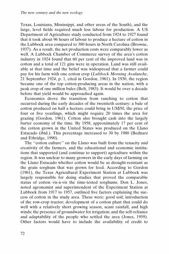
Texas, Louisiana, Mississippi, and other areas of the South), and thelarge, level ®elds required much less labour for production. A USDepartment of Agriculture study conducted from 1924 to 1927 foundthat it took about 96 hours of labour to produce a hectare of cotton inthe Lubbock area compared to 380 hours in North Carolina (Browne,1937). As a result, the net production costs were comparably lower aswell. A Lubbock Chamber of Commerce survey of the area's cottonindustry in 1924 found that 60 per cent of the improved land was incotton and a total of 121 gins were in operation. Land was still avail-able at that time and the belief was widespread that a farmer couldpay for his farm with one cotton crop (Lubbock Morning Avalanche,21 September 1924, p. 1, cited in Gordon, 1961). In 1930, the regionbecame one of the top cotton-producing areas in the nation, with apeak crop of one million bales (Belt, 1983). It would be over a decadebefore that yield would be approached again.
Economics drove the transition from ranching to cotton thatoccurred during the early decades of the twentieth century: a bale ofcotton produced on half a hectare could bring in US$50, the price offour or ®ve yearlings, which might require 20 times the area forgrazing (Gordon, 1961). Cotton also brought cash into the largelybarter economy of the time. By 1958, approximately 17 per cent ofthe cotton grown in the United States was produced on the LlanoEstacado (ibid.). This percentage increased to 30 by 1980 (Bednarzand Ethridge, 1990).
The ``cotton culture'' on the Llano was built from the tenacity andcreativity of the farmers, and the educational and economic institu-tions that supported (and continue to support) agriculture within theregion. It was unclear to many growers in the early days of farming onthe Llano Estacado whether cotton would be as drought-resistant asthe grain sorghum that was grown for feed. According to Gordon(1961), the Texas Agricultural Experiment Station at Lubbock waslargely responsible for doing studies that proved the comparablestatus of cotton vis-aÁ -vis the time-tested sorghums. Don L. Jones,noted agronomist and superintendent of the Experiment Station atLubbock from 1917 to 1957, outlined ®ve factors explaining the suc-cess of cotton in the study area. These were: good soil; introductionof the row-crop tractor; development of a cotton plant that could dowell with a relatively short growing season, scant rainfall, and highwinds; the presence of groundwater for irrigation; and the self-relianceand adaptability of the people who settled the area (Jones, 1959).Other factors would have to include the availability of credit to
The new century and the new ecology
72
®nance irrigation, land and machinery, and yearly inputs; and thegovernment's special commodity farm programmes. Without the lasttwo in particular, it would have been impossible to maintain cottonproduction in the Llano Estacado.
Complementing the trend toward greater acreages under cultiva-tion were the ongoing rapid innovations in farm equipment. Some200 different companies, including Ford Motor Co., McCormick-Dressing and John Deere, were manufacturing tractors by 1917 andcreating new equipment, like the one-way disc plough, which soonbecame essential to modern farming (Worster, 1979). It is importantto keep in mind that these were good-weather years (a tendencytoward drought in the mid 1910s notwithstanding) and H.W. Camp-bell's dryland farming methods were producing large yields and goodharvests. The one-way disc plough was designed to break up the sur-face soil layer into a ®ne ``crumb,'' as Campbell advised, in order toabsorb any available rainfall more completely. Farmers following therecommended practices would plough up the surface of their ®eldsafter every rain, supposedly to trap the moisture in the soil (Worster,1979; Widtsoe, 1911).
The stage was being set through cultivation practices, marketdemands, capitalization demands, and technological innovation foreither ever-increasing massively scaled agriculture, or an environ-mental and economic disaster on a massive scale. Writing at the veryend of the boom era, one researcher remarked that ``[t]he large scalesystem of agriculture now in vogue on the High Plains is producingand maintaining a thriving civilization with a newness and color all itsown'' (Gibson, 1932: 11). By the late 1920s, the grains±cotton vege-tative complex was a successful and permanent replacement ecologyfor the shortgrass and scrub complex. Dryland farming methods, inconjunction with higher than normal rainfall amounts, were pro-ducing high yields (Browne, 1937). As Worster (1979) describes it,nothing changed during the boom years; created conditions merelyaccelerated trends already established. The myth of the garden hadsuccessfully supplanted the myth of the desert at last through theperseverance and work of everyday men and women.
The bust
Of course, neither myth re¯ected the truth, although the spectre ofthe Great American Desert was about to loom large over the entiresouthern plains region once again. With the start of the new decade
The new century and the new ecology
73
came the end of the good weather. The southern plains were stunnedby a sudden onset of drought in the early 1930s. Droughts had comeand gone before on the plains ± small-scale farmers lost everything,dusted out, migrated east or further west, but on a small scale. Withlarge farms, heavy debt burdens, overextended, poorly managedlands, and no rain, farmers seemed destined to lose on a big scale.Evidence shows that the drought of the 1930s was not the severest onrecord.5 In fact, this drought is not even ranked among the ®ve worstdroughts since the early eighteenth century, as detected through tree-ring data (Worster, 1994: 101). However, the consequences of thedrought and the concurrent international depression were the eco-nomic and ecological devastation on the plains.
What made the Dust Bowl era one of the most disastrous episodesin the history of the United States? If it was not the result of theworst drought on record, why were the results of the drought theworst in living or recorded memory? The answer lies in that con¯u-ence of the several major developments in agriculture and the mar-kets for agricultural products in the 1910s and 1920s, and in thewidely held denial of the climatic reality of the region. In some waysit can be argued that expectations, both presumed and acted on,caused the Dust Bowl.
When the US stock market crashed on 24 October 1929, westernfarmers did not immediately sense that there would be any impactson their livelihoods or the economic health of their communities.There was a belief that because the West was built on actual re-sources, grain and ®bre in particular, speculation and investmentpractices back east were irrelevant. In reality, the West would suffermore and longer, for the markets for the commodities the westernhalf of the United States produced had collapsed.
On the southern plains and the Llano speci®cally, the immediateresponse to the commodities market collapse was to plant more wheat,creating a glut and driving prices down even further. The crisis deep-ened over the next few years, with increasing numbers of farmerssinking into debt as prices for farm products kept falling. Foreclosurerates soared as farmers were unable to keep the notes current ontheir equipment and land. Farm values dropped anywhere from 25per cent to 45 per cent between 1930 and 1935 (US Department ofCommerce, 1925±1935).6
Things were bad for cotton producers as well. High production hadsuppressed prices at a time of declining demand, following WorldWar I. In 1926, the price of cotton dropped dramatically. A poor
The new century and the new ecology
74
season resulted in crop losses of over 60 per cent in some commun-ities (Gordon, 1961). The cotton farmers joined the appeal for reliefassistance from the federal government. After a banner year in 1930,a large number of growers voluntarily curtailed their planting; thedeepening drought of 1934 reduced output even further. When thedrought continued into the early part of 1935, it was clear that it wasnot just another ``dry spell.'' These bleak years brought to an end theinitial phase of cotton culture development on the Llano Estacado ± aphase in which the individual was pitted against the uncertainties ofclimate and competitive market (Gordon, 1961). With the exceptionof the late 1960s, the number of farms in the area has been decreasingever since this period (®gure 4.1). And, although population increasedbetween 1930 and 1940 throughout the region as a whole, nearly halfof the counties lost population during the 1930s (US Department ofCommerce, 1900±1940).
Relief programmes aimed at the farmers were sparse and ineffec-tual prior to Franklin D. Roosevelt's election to the presidency in1932. Beginning in 1933, sweeping relief programmes were institutedwith the goal of getting cash and food into the hands of desperatefarmers. But for the farmers of the plains the worst was still to come.The spring of 1935 brought no rains, and in April the dust stormsbegan. The legendary storm of 14 April 1935 (Black Sunday) usheredin an era of unimagined ecological devastation for the southernplains. Enormous clouds of black dust from the plains blew across thecontinent, drifting on the streets and buildings of Washington DC andNew York City; even ships at sea found the ®ne black dust settling onthe decks (®gure 4.2). Drought had recurred throughout the knownhistory of the Llano; this time, though, when the drought returned,millions of hectares had been stripped of the indigenous grass cover,and were now exposed to the stiff winds that blew every spring. With
Figure 4.1 Number of farms (1900±1992)
The new century and the new ecology
75
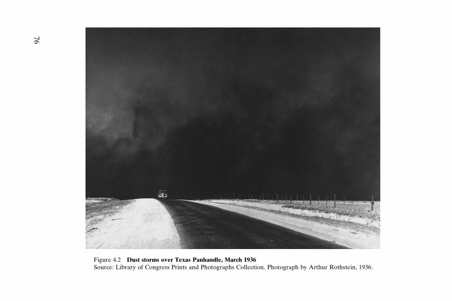
Figure 4.2 Dust storms over Texas Panhandle, March 1936Source: Library of Congress Prints and Photographs Collection. Photograph by Arthur Rothstein, 1936.
76
the added impacts of the drought, the result was staggering. Somehave estimated that 13,350,000 hectares (33,375,000 acres) werestripped of their grass cover and left vulnerable to severe erosion inthat spring of 1935 (Worster, 1979). A contemporary account (GreatPlains Drought Area Committee, 1936: 8) reported:
The dust storms of 1934 and 1935 have been visible evidence to nearly everyAmerican living east of the Rockies that something is seriously wrong. Theextent of erosion on the Great Plains has not yet been accurately measured.It is safe to say that 80 percent is now in some stage of erosion.
Furthermore, the blowing dust and erosion was ``a situation that willnot by any possibility cure itself. A series of wet years might postponethe destructive process, yet in the end, by raising false hopes and byencouraging renewal of mistaken agricultural practices, might accel-erate it'' (ibid.).
Survival
Intervention on many levels was necessary to stop the erosion, toprovide food and shelter to the thousands of dusted-out residents,and to preserve agriculture in the region. Federal programmes andintervention on a grand scale seemed essential. By merging recoveryefforts, several conservation programmes were begun that providedjobs and sought to mitigate the environmental destruction broughtabout by overproduction and poor farming practices. The ShelterbeltProgram was one of these. Its aim was to plant a shelterbelt of treesfrom the Dakotas to Texas to help ease wind erosion on the plainswhile employing thousands of displaced farm workers and labourers.Although the programme was somewhat successful in parts of theMidwest, there was simply not enough rainfall to sustain tree growthin the Dust Bowl counties (Worster, 1979).
Another early programme, the Drought Relief Service (1934), alsofocused on repairing the environmental damage resulting from over-grazing. Millions of cattle were bought by the federal governmentand moved off the range or killed ± 25 per cent of the cattle boughtwere on the Texas plains (White, 1991). A payment system was alsodevised to reimburse ranchers for reduced grazing and better watermanagement. This programme was not without strings; the TaylorGrazing Act was also passed that same year (1934). This Act requiredthat the grazing lands in the public domain be under federal control,administered by local boards, under the assumption that if over-
The new century and the new ecology
77
grazing could be controlled, more grass could be grown and the ero-sion problems would also naturally be controlled. How much of theplains should be returned to grassland for grazing purposes was sub-ject to debate. Memories of the 1880s cattle market crash and theincreasing glut of cattle raised questions about the wisdom of creatingmore rangeland.
Recovery
Permanent retirement of farmland and its reversion to grassland (anearly precursor to current calls for a buffalo commons on the plains)was a major aspect of the Great Plains Drought Area Committee'splan for recovery of economic and environmental health on thePlains. This committee, appointed by President Franklin D. Roose-velt, comprised the heads of various resource and agriculturalagencies, among them Hugh H. Bennet, the chief of the Soil Conser-vation Service, Harry L. Hopkins, Administrator of the Works Prog-ress Administration, Henry A. Wallace, Secretary of Agriculture, andthe chairman of the Rural Electri®cation Administration, Morris L.Cook. Reporting directly to President Roosevelt, the Committeecalled for voluntary retirement of ``submarginal'' farmlands andreplanting them with grass or trees. The most severely damaged lands(estimated at about 15 per cent of the total area) would be broughtunder government control. And the government would retain theauthority to restrict or prohibit certain practices by farmers on otherlands if those practices were considered to be potentially damaging(Great Plains Drought Area Committee, 1936). Most importantly,though, the Committee stated (ibid.):
The fundamental purpose of any worthwhile program must be to notdepopulate the region but to make it permanently habitable. Any otheroutcome would be a national failure which would have its effects, tangibleand intangible, far beyond the affected area.
The actual recovery programmes fell far short of the goal of perma-nent reversion of farmland. The notion of such clear governmentintrusion into everyday farming practices was not welcomed, despitethe helping hand the government was also extending. The emphasisshifted to temporary retirement. Under the Agricultural AdjustmentAct of 1933, the Secretary of Agriculture was given wide authority toraise agricultural prices in a variety of ways, the chief means beingpayments to farmers who reduced their farm production, and sec-
The new century and the new ecology
78
ondarily, to create marketing agreements for producers with directoversight by the US Department of Agriculture (Hansen, 1991).Paying farmers not to grow crops for which there was no market wasan effort to reduce surpluses and bring land out of production. Forfarmers, this was a radically different approach to farming, and itmade many of them uneasy; it soon became obvious, however, that itwas saving many farms from economic devastation. The AgriculturalAdjustment Act, characterized as a programme of planned scarcity,was amended several times throughout the decade, and stands as thefoundation of farm programmes even to the present day (White,1991).
Short-term retirement of farmlands was not solving the wide-scaleenvironmental problems, either. Recognizing that, the USDA movedahead with plans for land stabilization and created the Soil Conser-vation Service with the Soil Conservation and Domestic AllotmentAct of 1936. Moving onto the windblasted wheat®elds of the plains,federal experts introduced contour ploughing, terracing, and othersoil-conserving measures, meeting with some success in stabilizing thedune®elds so prevalent by the mid to late 1930s (®gure 4.3). Anothersuccessful offshoot of the Soil Conservation Service was the estab-lishment of soil conservation districts. In the recognition that farmerswould be more likely to follow locally organized programmes, soilconservation districts were organized at the grassroots level. Usinglabour from the Civilian Conservation Corps and from local farmersemployed through the Works Progress Administration, soil manage-ment techniques were demonstrated across the plains. Although thisrepresented a breakthrough in the political management of the envi-ronment of the plains, the districts, as they were slowly formed,``were a limited and illusory evidence of progress toward Great Plainsreform ± not true land-use planning groups, but only mechanisms topromote the agronomists' tools, methods, and narrow view of theland'' (Worster, 1979: 220).
Irrigation was believed to be the solution to recurrent droughts,but capital for investing in irrigation works was exceedingly scarce forfarmers who were barely surviving the depression and the weather.Irrigation was not new to the Llano Estacado; the cattle ranchers hadused wells coupled with windmills since the 1880s. By 1900, the exis-tence of subsurface water in the area was widely known and wasbeing mapped by the US Geological Survey. As Green (1973) said,the ``search for water'' was largely a search for the economically fea-sible technology to bring the water to the surface in quantities suf®-
The new century and the new ecology
79
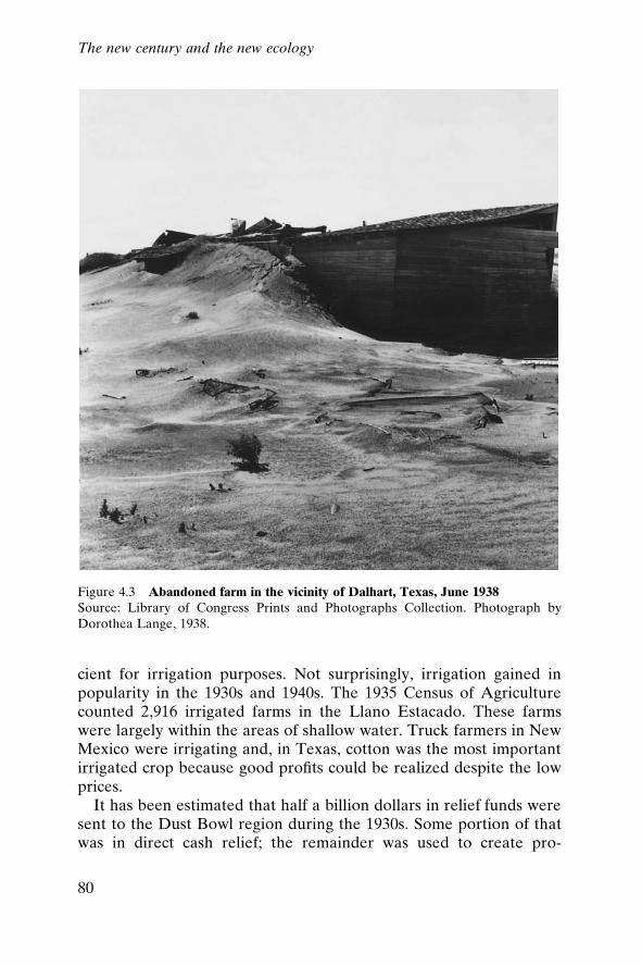
cient for irrigation purposes. Not surprisingly, irrigation gained inpopularity in the 1930s and 1940s. The 1935 Census of Agriculturecounted 2,916 irrigated farms in the Llano Estacado. These farmswere largely within the areas of shallow water. Truck farmers in NewMexico were irrigating and, in Texas, cotton was the most importantirrigated crop because good pro®ts could be realized despite the lowprices.
It has been estimated that half a billion dollars in relief funds weresent to the Dust Bowl region during the 1930s. Some portion of thatwas in direct cash relief; the remainder was used to create pro-
Figure 4.3 Abandoned farm in the vicinity of Dalhart, Texas, June 1938Source: Library of Congress Prints and Photographs Collection. Photograph byDorothea Lange, 1938.
80
The new century and the new ecology
grammes and agencies to support farmers over the long term. Amajor initiative coming out of the 1930s depression and farm crisiswas the Farm Security Administration.
Begun in 1937 in direct response to the uprooting of tenant farmersand the devastation of small farmers, the Farm Security Administra-tion sought to stabilize the small farmer and keep the family intact onthe farm. One goal was to cut surpluses by reducing cash croppingand turning acreages back to subsistence farming. An educationeffort was organized to teach farm families how to grow the food theyneeded and rely less on the cash economy (USDA, 1941). The majormarket for American farm products was Europe, and Europeanfarmers were rebuilding their own farm economies, resulting indecreasing demand for those products. The Farm Security Adminis-tration created a series of complementary programmes that sent Ad-ministration workers into the farmers' homes to outline strategies forbecoming solvent and self-suf®cient. They met with mixed success.The aims of the Farm Security Administration programme embodiedthe ideal of the yeoman farmer held dear from the earliest days ofwestward expansion. A patchwork quilt of small farms spread acrossthe plains, all independent and engaged in self-suf®cient agriculture,was seen as the optimal path to national as well as personal security,a guarantee against the despair and crushing poverty all too evidentin the late 1930s in the agricultural sector of the United States.
As the plains slowly emerged from underneath the metres-deepdrifts of sand and dust, with the return of the rains in the early 1940s,several factors leading to the environmental disaster became moreobvious. Not only were the farming practices disastrous, overridingeconomic and global political conditions also reinforced the trend tocareless and unconsidered farming. Competitive farming led to theconsolidation of farmlands, resulting both in huge unprotected tractsof ploughed land, but also in increasing tenancy. Many people, if notmost people, ¯eeing the Dust Bowl were ``tractored out,'' not neces-sarily ``dusted out.'' As farmlands were bought up to maintain pro®tlevels against falling grain prices (the answer was always to put moreland under cultivation), those farmers who could not compete losttheir lands to suitcase farmers. Tenants were also the ®rst to go whentroubled economic times arose. There was more money to be made ifthe farmer could tend all the land himself without renters. One manwith a tractor could cover more land in a day than any number oftenants; labour costs fell and maintenance costs for equipment werealways lower than the costs of maintaining farm labourers. Any of
The new century and the new ecology
81
these trends without the potential for serious drought in any givenyear probably could have been successfully modi®ed and continued.But the fact of water scarcity, in light of the highly variable climate,was undeniable.
In the end, what lifted the High Plains out of the Dust Bowl andthe Depression were institutional arrangements that made temporaryrelief programmes into permanent farm support programmes, and,most importantly, the discovery of an apparently inexhaustible watersupply to replace the farmer's eternal dependence on rain. The ulti-mate toll of the Dust Bowl years is incalculable: 800 million metrictonnes (850 million tons) of earth blown away each year; 900 metrictonnes per cultivated hectare (408 tons per acre); 12 centimetres oftopsoil blown off 4 million hectares, and at least 6 centimetres lost offanother 5.5 million hectares, all by 1938 (Worster, 1979: 29). At anygiven time during the period, one-fourth to one-half of all farmers inthe region were on relief, employed through the Works ProgressAdministration or getting cash payments or low-interest loans. A totalof 3.5 million people had left the Dust Bowl region by the end of the1930s, 2.5 million of them farmers (West, 1990).
The data speak volumes, but the photographs of Dorothea Lange,the songs of Woody Guthrie, and the books by John Steinbeck andPaul Taylor revealed the human cost that cannot be captured bynumbers. Hopes and dreams were destroyed along with the topsoil.Health was ruined along with cropland. Dignity and independencedisappeared with the emergence of the overpowering need for assis-tance and charity. A way of life was very nearly lost; for those forcedto migrate, that way of life was lost forever.
Native Americans, displaced from their lands, were also subjectto the economic and environmental disasters of the 1930s. TheComanches earned some income from leasing allotments to Anglofarmers, but with downturns in agricultural prices those leases be-came worthless. In addition to lease money and per capita paymentsfrom the sales of the allotment lands (194,260 hectares, or 480,000acres, along the Red River left over from joint ownership), somecapital was obtained through employment in the Anglo economy. Butout of 4,683 Kiowas, Comanches, and Apaches in 1934, only 15 hadfull-time jobs (Foster, 1991: 105). Many, perhaps one-fourth, receivedgovernment relief. Outright sales of allotments (perhaps the intent ofthe Allotment Act all along) then became a means of survival formany families. Some claim that sales of allotments were activelyencouraged by the local Indian agency, and by 1940, some 65,000
The new century and the new ecology
82
hectares (160,000 acres) out of a total of slightly more than 218,500hectares (540,000 acres) had been sold (Foster, 1991).
Moving ahead
The history of the Llano has been marked by boom years and bustedlives. As the ``Last West,'' the region seemed destined to be therepository for all the remnants of frontier dreams. Sturdy pioneersstruggling to make new lives against occasionally overwhelming oddsrepresented the idealization of the American experience. Even in theface of the complete destruction brought by the raging dust storms,that ethos seemed indomitable. Without irony, the Lubbock Chamberof Commerce applied in 1934 to the Texas Rural Homes Foundationto create a farming community in the vicinity of Lubbock. Its mainpurpose? To offer to as many as 100 of the 1,000 families on relief inthe city of Lubbock the opportunity ``to return to rural life and startfarming thus developing income, reducing relief rolls, and producingfood and ®ber,'' and becoming ``self-supporting'' (Lubbock Chamberof Commerce, 1934). The reality of the environmental conditionswas, nevertheless, undeniable. As the region slid into drought con-ditions with an unpredictable but ominous regularity, it was perceivedas a challenge to the character and strength of will of the settlers.Those who managed to stay on did well in good years, and thereforewere in a better position to take advantage of government pro-grammes and to persevere through the bad times.
But the survival of a few provides the material of lore to pull othersto the region. And, gradually, an identity is created, that of a peoplewho de®ed the odds and prevailed. Thus, in remaking the Llano, thesettlers remade themselves. With the descent into the Dust Bowl, theywere in danger of losing that sense of identity. The federal-level re-sponse recognized this (Great Plains Drought Area Committee, 1936):
The nation has pro®ted by the courage and endurance of the people of thePlains. We have all had large responsibility for the direction of the settle-ment and for the development of agricultural conditions in the area. Wecannot discharge ourselves of the obligation thus incurred until we havehelped them create, within the natural and climatic conditions which canbe prepared against but cannot be controlled, a secure and prosperousagriculture.
But, in the end, the Llano remained a region in search of a founda-tion to support the economy built there. Without the water more
The new century and the new ecology
83
humid regions take for granted, agriculture and the way of life de-pendent on it are uncertain. The troubled decade of the 1930s, andthe hard times brought about by overproduction and misguideddreams, left their mark. Physical scars on the land served to remindpeople of how treacherous the climate could be. Episodic droughtcame to be an expected companion to life on the Llano. Single badyears such as 1917, a year of very low rainfall, came and went. Butthe prosperity brought about by robust markets and pressing demandsfor what the plains can produce under the best of circumstancesguided beliefs about the ever-possible potential for the plains, asalways, in ``next year country.''
Notes
1. Data are for Bailey, Cochran, Crosby, Floyd, Hale, Hockley, Lamb, Lubbock,Parmer, and Potter counties.
2. Again, these data are from the ten counties listed in note 1 above.3. The Station was opened shortly after the report was issued. A short-lived drought
that year was so severe that all of the demonstration crops failed.4. White (1991) reports that the new farm machinery displaced so many horses that
the French government sent cavalry of®cers to the western United States to pur-chase surplus horses for military use during World War I.
5. Recent (1996±1997) drought conditions on the southern plains are considered farmore extreme than conditions during the 1930s, for example. By mid-May, 1996,crops on 4,451,700 hectares (11 million acres) had been lost (Wall Street Journal,22 May 1996).
6. These ®gures are given for the average percentage decrease in total farm value forthe ten representative Llano counties listed above.
The new century and the new ecology
84
5
Expansion and exploitation:1945 to 1980
Recovery and maintenance
The post±World War II era was a time of tremendous growth inagricultural production, standard of living, and population on theLlano. The industrial boom, spurred by wartime production levelsand fuelled by a vigorous domestic economy, also supported wide-spread investment in technological innovation, and its subsequentimplementation in the farmers' ®elds. Farmers on the Llano bene®tedfrom all of these factors, resulting in an unprecedented era of growthand prosperity for the region. Early on, in the early 1950s, it didappear that a permanent, inexhaustible supply of water was beneatheveryone's feet just waiting to be used. The ®rst great wave of irri-gation brought incredible success. In true homesteading fashion,everyone rushed to stake their claim to the immense supply. Perhapsin an effort to ``prove up'' that claim, water was pumped at a furiousrate for the ®rst twenty or so postwar years. As wells began to dry upand drillers went deeper and deeper, some began to acknowledgethat there might in fact be a limit to the water, economically orphysically.
The chief responses to the dust storms, drought, and misery of the
85
1930s were institutionalized conservation practices, farm subsidy andsupport programmes, and the search for a reliable source of water.The last of these ± having adequate water ± was believed to be theunderlying solution to all the problems of settling and maintainingagriculture on the Llano. As Webb (1931) tells the story, ``[t]hiswould be a ®ne country if we just had water,'' the new settler isreported to have said to a dusted-out farmer. ``Yes,'' comes the reply,``so would hell.'' In ``next year'' country, an adequate rainfall in thespring after decent snowfall in the winter is always the solution to thecurrent year's drought (Worster, 1979). The irrefutable truth thatevery dry spell ended with a rain drove the farmer to hold out if at allpossible for one more year. Finding a means of providing a steadyand reliable water source would surely resolve once and for all thequestion of the suitability of the plains for livelihoods and commun-ities built on agriculture. And it was yet to be proven that cottonculture and ranching were feasible long-term options for the Llano.
Water
That water existed under the sod at some distance was widely known.Windmills dotted the plains, drawing water for watering tanks on therange and supplying the farmhouses' needs. In 1898/99, Willard D.Johnson, a geologist with the United States Geological Survey, com-piled a detailed analysis of the climate, vegetation, soils, topography,and water resources of the High Plains. His report, The High Plainsand their utilization, described with surprising accuracy the extent ofgroundwater reserves on the plains. Johnson (1900±1901, 646) alsoresponded to the Irrigation Age enthusiasts:
There is a prevalent belief that means will be devised by which, acre foracre, this great accumulation of water within the ground may be put to irri-gation use on the surface. At the same time, a notion, ®nding its expressionin the generally accepted term ``under¯ow'' and involving serious error sofar as contemplated results are concerned, prevails, also to the effect thatgroundwater has lateral motion fairly comparable to that of surface water ±i.e. that it is continually renewed at such rate that it could be inexhaustibleas a supply for irrigation.
However, Johnson explained (1900±1901: 653), the potential useful-ness of the groundwater on the plains was confounded by the natureof the resource:
Expansion and exploitation
86
The volume of loss which the body of the ground water sustains annuallycan be no greater than that of the contribution to it annually. [Thus] [t]hedraft for general irrigation would need to be at a rate considerably less thanthis small rate of replenishment, to avoid serious lowering of the water plane(to prevent early depletion), and such a very limited supply, even if obtainedat no expense for lifting, would be of no material bene®t in irrigation.
In short, Johnson concluded, ``[a]gainst the High Plains, . . . the abso-lute verdict must be that they are nonirrigable'' (ibid.).
Thirty years later, the noted historian of the plains, Walter PrescottWebb, concurred. Comparing the groundwater reserves of the plainsto a bank account, Webb explained that to maintain a balance, with-drawals must match deposits. ``If the withdrawals should be appreci-ably increased for purposes of irrigation, the bank account woulddecrease correspondingly . . . and since the amount of deposit is ®xedon an average, the loss could not be made good'' (Webb, 1931: 331).
But neither of these experts could reckon with the determinationof the farmers and government of®cials to remake the plains into anirrigated paradise. Charles Dana Wilber stated it succinctly: plainsfarmers believed in the ``grand consent or, rather, concert of forces ±the human energy or toil, the vital seed, and the polished raindropthat never fails to fall in answer to the imploring power or prayer oflabor'' (quoted in Smith, 1950: 182). For every Powell and Webb,there was an opposing voice asserting that, given insuf®cient rainfall,``irrigation waters could be produced in unfailing quantities'' fromunderground supplies, and moreover, ``that water is almost, or en-tirely, free from minerals that are injurious to plants, and the level toundulating topography and fertile friable soils are excellent for uti-lizing irrigation waters'' (Browne, 1937: 169). Although the farmershad a very strong sense of obligation to future generations and towise stewardship of the land and its resources, they also held anequally strong conviction that a way would be found. If the water wasnot inexhaustible, it could be made to seem that way with greaterinvestment in pump technology and energy outlays.
The belief in the ability always to ®nd a way, however unfounded,has taken on different expressions over the years: In the 1950s, limit-less energy was key; in the 1960s and 1970s, high crop prices andextravagant water importation schemes were the answer; in the1980s, world commodities markets and price supports kept the wateraffordable as depths to water increased; and ®nally in the 1990s, plans
Expansion and exploitation
87
to tap deeper fossil water reservoirs, along with re®ned conservationstrategies, seem to provide the answer to the question of where thewater will come from.
The reality of groundwater reserves on the plains was accuratelydepicted by Johnson. The High Plains Aquifer system is a vast, irreg-ular con®guration with widely varying depths to water and varyingsaturated thicknesses. The great variability in depth to water acrossthe High Plains Aquifer meant that reliable pumping technology wasessential to maintaining a steady ¯ow of water to the surface. Depthsto water across the Llano alone ranged from a metre or so in the eastto several hundred metres in the west. The application of motor-driven technology to pump design enabled farmers to reach depths towater inaccessible from windmill pumping. Although the technologywas available around the turn of the century, the expense and dif®-culty of maintaining the equipment limited its use. Energy sourceswere problematic. Steam-driven pumps needed constant surveillance,and the alternative, electrically powered pumps, required electri®ca-tion and power lines strung out to the ®elds (Bowden, 1977). Theseearly models were cumbersome, prone to breakdown, and inef®cient,making them very expensive to operate (Green, 1992).
The internal combustion engine, imported to the United States inthe early years of the twentieth century, proved promising. At roughlyUS$4,000 (in contemporary dollars), irrigation plants were an invest-ment that farmers wished to put off as long as possible (Bowden,1977: 116). And, with the mostly good weather of the early decades,it was easy to postpone that investment. As the pumps were mademore reliable and their range increased, it would become more fea-sible to invest in them. Nevertheless, there were only a few hundred``pumping plants'' across the southern plains by the outbreak ofWorld War I, drawing mostly from the so-called shallow water belt(Green, 1992). Interest in irrigation lagged through the 1920s, ashigher than normal rainfall continued and crop prices dropped. Withthe drought of the 1930s, those who could afford to invest in irrigationdid so, as boosters ceaselessly promoted its bene®ts. The loosenedcredit brought by government relief programmes made the investmentaffordable. With the drought, all crops needed extra water, not justthose that could not be successfully dry-farmed. Soon reconditionedautomobile engines were powering pumps at half the cost of the pre-cursor models ten years earlier. When a simple, direct-drive way oflinking the motor and the pump was devised, ef®cient, dependable,and relatively inexpensive pumping plants became feasible. By 1940,
Expansion and exploitation
88
there were roughly 2,200 irrigation wells, watering over 100 hectares(about 250,000 acres), a huge increase over the 170 wells and perhapsone hectare total (under 3,000 acres) in 1930 (Bowden, 1977: 119).
Irrigation did not become truly widespread until after World WarII. Not only were war-era innovations improving technology, fuel wasalso becoming cheaper. The discovery in the 1950s of extensive nat-ural gas ®elds in the southern plains brought plentiful and inexpen-sive fuel right to the farmers' ®elds. Without the severe drought ofthe mid-1950s (``The Big Thirst''), though, it is doubtful that wide-spread and eager adoption of irrigation agriculture would havecaught on quite so quickly.
All aspects of irrigation technology continued to evolve rapidly.The development of cheap and lightweight aluminium pipe afterWorld War II meant farmers could single-handedly recon®gure theirirrigation schemes quickly as conditions warranted; the new pipesalso meant that less optimal land could be irrigated, since farmersno longer had to rely on gravity-¯ow ditch systems. Putting the pipeson wheels, an innovation introduced in 1950, made placement eveneasier (Green, 1992). Shortly after that, the centre pivot sprinkler wasintroduced. Irrigation expanded as farm credit programmes made the®nancing of irrigation systems possible and the belief spread, in theface of the facts, that the aquifer was a ``vast underground river,continuously recharged with snowmelt from the Rockies''; farmers``exchanged stories about . . . incidents of blind trout . . . and othersuch evidence (found in) the irrigation ditches'' (Urban 1992: 206).1
Irrigation and regulation on the Llano
Archeological evidence exists showing that irrigation has been prac-tised on the plains for centuries, long before European arrival.Without any formalized consideration of whose water it was or whohad the right to use it, irrigation continued on a small scale in therecent past, with windmill-driven pumps bringing water up from theshallow depths to water cattle, for example. Large-scale, widespreadirrigation came about with the development of technology to gainaccess to non-artesian water and water at lower depths.
The move to regulate the use of groundwater coincided with thedevelopment of irrigation technology. In Texas, the two events areonly marginally related. The move to institute some sort of controlover groundwater use on the Texas Llano was fundamentally a moveperceived to preserve the independence of the residents of the Llano
Expansion and exploitation
89
against the intrusive action of the state, and potentially the federal,government (Brooks, 1996). The people of the Llano were acting topreserve an identity, steeped in a way of life.
The move to manage groundwater
The threat of recurrent drought throughout the ®rst half of thetwentieth century seemed to be eliminated by the access to ground-water in the years immediately after World War II. Technologicallyadvanced irrigation systems and powerful new pumping plants pro-vided the steady rainfall the region lacked. Throughout the 1950s,wide-scale withdrawals provided the water. The unchecked waterwithdrawals soon began to affect the aquifer, increasing the depthfrom which the water was pumped, and the costs. As early as the late1940, concerns were being voiced about depletion, although thedominant view was still that a vast network of ¯owing rivers existedunderground. But those concerns were enough to spur debate aboutthe possibility of some sort of imposed management.
Larger state politics also were playing a role. Throughout the 1940sthere had been several attempts by the Texas state legislature todeclare underground waters the property of the state ± surface waterhad been so designated earlier. As early as 1917, the Texas legisla-ture had approved a so-called conservation amendment to the state'sconstitution, which required the conservation of ``all of the naturalresources of the state'' (Cisneros, 1980). Although the amendmentenabled the legislature to enact conservation laws, none were createdwith regard to groundwater. In 1937, in response to the expansion ofirrigation in the state, the ®rst attempt at a bill enacting comprehen-sive groundwater management was presented to the state legislatureand failed. Three subsequent attempts in 1939, 1941, and 1947 alsofailed (Templer, 1992). Then, in the winter of 1947, legislation wasraised to declare groundwater property of the state in the WinterGarden region only. The Winter Garden, an area comprising ®vecounties in central south-west Texas, was a highly productive agri-cultural region, and the legislation was considered essential to pre-serving the water used in irrigation.
This move by the state legislature alarmed the people of the Llano.Perceived as a ®rst step towards the eventual control of the HighPlains Aquifer, the representatives of the Panhandle/Plains objectedto the passage of the bill. The Winter Garden Bill was passed overtheir objections, and later in that legislative session, another bill was
Expansion and exploitation
90
presented, the so-called Jameson Bill, which proposed making allunderground water the property of the state. Met with outragedopposition, the Jameson Bill failed in committee. But the die hadbeen cast, and the move toward some form of regulation begun.
Water management policy, and particularly groundwater manage-ment, in Texas had been marked by a generally laissez-faire attitude.This was expressed judicially in 1904, when the Texas Supreme Courtfound that landowners had an essentially unrestricted right to with-draw water found beneath their land (Cisneros, 1980).2 In a policycharacterized by legal scholar Johnson (1982) as ``a policy of . . . non-intervention,'' the state adhered to the common-law principle ofownership, which provided total ownership of all resources pertainingto a parcel of land. Operationally, this principle, characterized as``heaven high and hell deep,'' was followed by users of groundwaterthroughout the state, but was especially enthusiastically embraced onthe Llano. The notion of rights as something to be conferred by a civilpower did not sit comfortably with the water users of the Llano.Rights of use were instead earned by virtue of having wrested theland from the grip of Nature and transforming it into productivefarmland: these were rights ``earned by blood.''3
Concern about state or even federal encroachment on water usewas heightened nonetheless. Reasons to be apprehensive were foundin the state's growing role in everyday life and the possibility of thefederal government's involvement. Proposed state water projects,such as the damming of small rivers in the Texas Panhandle, werecharacterized by some as ``creeping socialism'' and admonitions wereraised about becoming too dependent on state help.4 In this climate,some on the plains thought it would be prudent to develop a home-grown strategy for dealing with what seemed to be the inevitablestate intervention in water use.
The Llano representatives to the state legislature in Austin beganto formulate a legislative response in 1948, in a move designed to pre-empt any further action by the state. Locally based managementplans were drafted and submitted to the legislature for considera-tion. One of these proposals, House Bill 162, also known as the HoltBill, was passed by the Texas Senate in April 1949. It was then sentto the Texas House who passed the bill in late May 1949. Speci®cally,the Holt Bill proposed codi®cation of four basic principles: ``To rec-ognize individual ownership of underground water, to conserve, pre-serve, and protect underground water, to prevent waste of under-ground water, and lastly, to recharge underground water.'' The
Expansion and exploitation
91
vehicle for this would be locally based groundwater management;the legislation provided for local elections creating a groundwatermanagement district on the Llano. Farmers and property ownerswould vote in county-wide elections to decide whether to includethemselves in a management district. The district or districts would belocally run, with board members and of®cials elected for a speci®cterm of of®ce, and residents of a given county voting for establish-ment of the district would voluntarily submit to regulation of theirwater use. The four basic points of the legislation were consideredthe foundation and thus the guidelines for any prospective manage-ment policies.
The late 1940s and early 1950s stand out as an era of great activityaround the issue of establishing groundwater management. The be-ginning of the transition from a totally individualistic, self-interested,unregulated resource scenario to a centrally based, voluntaristic sys-tem of groundwater management was signalled by the concern raisedover state actions to control the water. Widespread debate over theappropriate role of authority in an individual's exercise of his or herrights ensued, a debate whose subtext was the importance of main-taining a particular cultural identity honed by a generation of pio-neers (Brooks, 1996).
Because so very much was at stake in the decision to create agroundwater management district on the Llano, the months leadingup to the elections became a time for considerable questioning andinquiry. Compliance with programmes requiring changes in farmingpractices had a mixed history in the region. The farm relief effortsof a decade earlier were successful over the long term if farmersbelieved they were still able to opt for their best judgements, it can beargued. The soil conservation practices introduced by governmentexperts were less readily adopted and were quickly abandoned oncethey were no longer perceived to be necessary. For farmers to adoptthe water conservation measures implicit in creating a managementdistrict would mean accepting limits on their practices and on theirclosely held beliefs.
The debate and the issues
The debate took place over a period of several months, and was heldlargely through open meetings and hearings sponsored by the TexasBoard of Water Engineers. These hearings were well attended and
Expansion and exploitation
92
transcripts were reprinted in the local newspapers. Farmers and otherproperty owners needed little encouragement to voice their opinionsboth for and against the district, and experts and local of®cials werethere to answer questions. The meetings were generally held at localschools, community rooms, or town halls. The participants were rel-atively well-off: property ownership was a condition of electoral par-ticipation and the standard of living was fairly high on the southernplains.5
The issues that mattered most to the people of the Llano withregard to creating a groundwater management district make sense inlight of their perception of their own history. Many of these ``hardysons of pioneers'' were the ®rst generation of Euro-Americans tohave been born on the Llano. Nearly everyone was no more than onegeneration removed from the original settlers. The image of the lonepioneer ± with his family of course ± battling the ®erce climate and,after persevering through repeated hardships, triumphant amidstgreat material wealth, cast a long shadow over the debate.
Consequently, the farmers of the Llano were most concerned aboutthe erosion of their control over their own affairs. The locus of thepower inherent in the proposed management district was critical ±state-level or, worse yet, federal-level agencies were anathema on theLlano. Also important was the notion of being free to perpetuatecertain farming and grazing practices and other customs, all of whichcontributed to a generalized concern of maintaining a sense of iden-tity historically derived.
Whether or not the district would make a difference in the practicallife of the aquifer was also important. ``Water . . . [is] the life blood ofthe plains,'' banner headlines proclaimed, in support of the district'sformation.6 Because of that widely acknowledged truism, responsibleaction was required of the people of the Llano in order to preserve away of life. That argument was countered by those who maintainedthat ``the fact is, the land owner himself does conserve and protect hisproperty, both his water and his land.''7
Ultimately, 12 of the 21 counties participating in the election votedto create a groundwater management district, roughly 1.9 millionhectares (4.8 million acres) in size. (The decision was binding only forthose counties that voted in the majority for the district.) All othercounties on the Llano were not included. Many aspects of the districtneeded to be implemented before it could begin to act: boards ofdirectors and committee people had to be elected, by-laws written,
Expansion and exploitation
93
and general district organization decided. By January 1952, electionswere held to appoint the leaders and committees of the district, and anew era on the Llano had begun.
The First Underground Water Conservation District
High Plains Underground Water Conservation District No. 1 (HPa1hereinafter) was the ®rst formalized recognition of the transientnature of resource stability on the Llano. Although compliance wasessentially voluntary, and wells incapable of pumping a minimum of378,500 litres (100,000 gallons) per day were exempted, HPa1 hadcertain powers that could, on paper, impose real limits on ground-water withdrawals within the designated ``underground water reser-voir,'' the boundaries of which were coterminous with the district.The order issued by the state of Texas creating the district detailed itspowers and responsibilities:1. Formulation, promulgation and enforcement of rules and regula-
tions to conserve, preserve, protect and recharge the undergroundwater in the designated reservoir;
2. Formulation, promulgation and enforcement of rules and regula-tions to prevent waste of underground water;
3. Requiring of permits for drilling and completion of wells, and theissuance of said permits when the conditions are in compliancewith the requirements of the above;
4. Provide for well spacing, to prevent excessive drawdown or reduc-tion of artesian pressure. However, no one will be denied permis-sion to drill a well on his or her own land, subject to numbers 1and 2;
5. Requiring records to be kept and reported on drilling and com-pletion of wells, and also drillers' logs;
6. Acquisition of lands for water projects (dams, drainage, rechargeprojects) but never of water, underground or surface;
7. The conduct of underground water surveys by professional waterengineers;
8. Development of comprehensive plans for most ef®cient use ofunderground water and to prevent waste of that water, and tocarry out research, collect and maintain data, and publish thatinformation for the bene®t of the water users and other interestedparties;
9. Enforcement of rules and regulations, through the courts, by in-junction or other remedy, after notice is duly given.
Expansion and exploitation
94
(Text of Order Upon Hearing and Granting Petition To Create HighPlains Underground Water Conservation District a1, 9 August 1951).
The authority of HPa1 was challenged by many disgruntled farmers,particularly on the issue of tax assessment ± the district was author-ized to levy a tax to fund the district's activities. But, overall, becausein reality the district's powers were quite limited, support for it grew.Over time, elections were held for other counties to decide onwhether or not to join. (In 1999, the district extended to 15 countieson the Llano.) The impact the district's activities had on water usepractices was always constrained by the af®rmation of individual pri-vate ownership of groundwater by the owner of the land, althoughthe district reported a decrease in water application rates to 3,049cubic metres per hectare per year (one acre-foot per acre per year) inthe 1980s from 6,098 cubic metres per hectare per year (two acre-feetper acre per year) in the 1950s (Templer, 1985).
One area in which HPa1 has had a major impact is in the ful®l-ment of its duty to collect and make available data on groundwater.Its monthly newspaper, The Cross Section, has a circulation of around6,000 readers and serves as a forum for the dissemination of infor-mation about innovations in irrigation techniques, crop research, andconservation practices. In addition, the district distributes annualmaps detailing water use and decline over the district's territory.Water use might have been more sensitive to market demands thanconservation practices, but at least the farmers knew exactly whatthey were doing to the aquifer.
Part of the impetus behind keeping the water users and others sowell informed was the belief that ``the surest way to conserve wateris to make each farmer and land owner anxious to police himself''(May, 1962). Throughout the 1950s, 1960s, and 1970s, water use ex-panded rapidly, however. Clearly, farmers were responding to thehigh prices being paid for crops, the availability of credit to ®nanceexpensive irrigation works, inexpensive energy to run the pumps, andan almost overwhelming sense of destiny.
The role of water institutions throughout the 1950s and early 1960scentred around the promotion of conservation, support for researchinto aquifer recharge, and public education about the importance ofwater to the region. This was an era of great optimism in the UnitedStates: wealth was increasing and was reaching more and more people(Potter, 1954). On the Llano, people were experiencing economicgrowth as well. In 1955, for example, Lubbock, the ``Hub City of the
Expansion and exploitation
95
South Plains,'' ranked ®rst in the nation among cities of comparablesize (around 120,000 population) in per capita income, per familyincome, and effective buying power (Lubbock Chamber of Com-merce, 1955). Belief in technological innovation was strong as avail-ability of consumer goods and industrial output soared.
When alarms were raised over the dropping water levels ± as muchas three metres (nearly ten feet) in some parts of the Llano in 1954alone ± the district moved to educate farmers about federal waterimportation schemes.8 The appropriate response would take fulladvantage of technology and capital. These massive projects relied onessentially unlimited energy inputs and perceived water surplusesand involved hundreds of miles of canals to bring excess water toareas of water de®cit. In particular, HPa1 strongly advocated theTexas Water Plan, formulated and eventually submitted to electoraldecision in 1969. The Plan proposed a series of canals to deliverroughly 11 billion cubic metres (about 9 million acre-feet) to westTexas and eastern New Mexico from the Mississippi River system, adistance of over 1,200 kilometres (about 800 miles) with a lift of morethan 1,000 metres (3,000 feet). The energy budget for the plan wasestimated at roughly 40 per cent of Texas' electricity usage in 1970 ±7 million kilowatts (Bowden, 1977: 121). The imported water, it wasplanned, would be stored in the dewatered aquifer, replacing theexhausted groundwater with the inexhaustible Mississippi, assumingits riparian states would allow it. Promoted as the answer to any waterneeds in the future, the plan was nevertheless voted down, probablydue to its 9-billion-dollar price tag and the spectre of federal involve-ment (Urban, 1992).
The district's role
Despite its activism on behalf of the failed importation scheme, thedistrict regrouped and refocused its efforts, after the proposal'sdefeat, on conservation of groundwater to offset the annual drop ofroughly a metre (three feet) in the water table.9 Since technologicalanswers on a massive scale were clearly no longer an option, atten-tion was turned to the small scale. Continued innovation in irrigationtechnology seemed to provide a means of using the water more ef®-ciently, and the district was committed to sponsoring research in irri-gation equipment and practices. Test plots were set up and demon-strations conducted. HPa1 representatives canvassed the area andpointed out waste problems, like open and unlined ditches, furrow
Expansion and exploitation
96
irrigation, and unreturned tailwater (runoff from irrigated ®elds). Thedistrict also used its enforcement powers to issue citations to farmerswho neglected to correct wasteful practices.
Nevertheless, water use expanded in the 1970s, with wildlyincreasing withdrawals; HPa1 also grew in prominence. Althoughthe Board of Directors argued that the district was an active force ingroundwater management, its role was still chie¯y one of educationand research.10 Signi®cant advances in the ef®ciency of irrigationusing new techniques and more re®ned equipment, particularly theincreased spread of centre pivot irrigation systems, contributedsomewhat to conservation of water; still, the 1970s was an era ofunprecedented withdrawals from the aquifer. With the onset of theenergy crisis in the late seventies, however, and the shifting worldmarket for the agricultural products of the Llano, farmers could nolonger afford to pump their water from such great depths in suchgreat quantities.
Water withdrawals continued to decline throughout the 1980s, andthe agricultural economy adjusted as well. The district's role as edu-cator grew more important, with programmes on water conservationdesigned for the public school system, expanded demonstration proj-ects, and more research into increasingly ef®cient irrigation systems.An example of these is a modi®ed form of centre pivot irrigation, theLow Energy Precision Application System, or LEPA, which reduceswater waste from 40 per cent with conventional furrow irrigation toabout 5 per cent (HPUWCD a1, 1995). However, HPa1's ability torestrict irrigation or curtail certain inef®cient or wasteful practicesremained quite limited.
Water use and exploitation
It could be argued that irrigation expanded in advance of the datanecessary for its ef®cient or even proper use. Water use was uncon-sidered and wasteful. Crops requiring no more than 30 to 45 centi-metres (12 to 18 inches) of supplemental water were routinely beingirrigated with over 60 centimetres (24 inches) of (non-renewable)groundwater: clearly if a little extra water was helpful, then a lotmore would be even better (Urban, 1992: 206).
Groundwater exploitation is perceived to have hit its zenith in the1960s. There were 71,000 wells, irrigating about 2.6 million hectares(6.4 million acres). Agricultural production surged in the region: 34per cent of Texas cropland was plains farmland, and 69 per cent of all
Expansion and exploitation
97
irrigated cropland in the state was on the plains (Urban, 1992: 207).Not surprisingly, withdrawals from the Ogallala peaked in 1977 atroughly 10.16 billion cubic metres (about 35,893,440,000 cubic feet or8.24 million acre-feet), according to Urban (1992).
Since the 1970s, groundwater use has steadily, and sometimes pre-cipitously, declined. Some areas of the Llano have reverted to dry-land farming practices, ending irrigation altogether. There are manyreasons behind this transformation: energy costs, changing demand,increasing depths to water, and the institution of formalized manage-ment. In sum, the inexhaustible water supply was giving out, for allpractical purposes.
Conservation practices in the post-war years
Many of the conservation practices brought to the Llano through therelief programmes of the 1930s were abandoned with the return ofadequate rainfall in the 1940s, and the burgeoning demands for grainand ®bre resulting from the United States' war effort and the needs ofEurope. The Shelterbelt programme was unsuccessful on the Llanochie¯y because the rainfall was insuf®cient to support lush treegrowth. Conservation tilling practices were neglected as farmers wereonce again exhorted to plant fence line to fence line to meet wartimeand post-war demand.
The Dust Bowl consequences were considered lessons learned; thegeneral consensus was that times had changed and things were dif-ferent now. One major difference was the expansion of irrigation fedby the exploitation of groundwater. It was dif®cult to persuade farm-ers to keep ®elds in grasses when the prices for irrigated cotton andcattlefeed were soaring.
Some of the lands that had been retired and entered into Depart-ment of Agriculture reserve programmes through the Land Utiliza-tion Project were allotted to the Soil Conservation Service. Theselands, some 4.4 million hectares (about 11 million acres) across 45states, included some of the most severely damaged in the Dust Bowlregion (West, 1990). The Soil Conservation Service projects includedreclaiming these lands for improved range and grazing, recreation,wildlife habitats, and watershed protection, employing farmers andothers on relief.
The ultimate goal for these Land Utilization Projects, however,was not permanent retirement but rehabilitation out of farmland andinto rangeland (West, 1990). Eventually these grasslands were folded
Expansion and exploitation
98
into the National Forest System. Problematic at best, the incorpora-tion of grasslands under forest management policies has led to aconfused mission regarding the preservation of these lands. In theend, though, a major aim of the grasslands programme was to pro-mote grasslands agriculture.
The most active conservation programmes on the Llano todayconcern irrigation practices. Innovations in water application andcapture of return ¯ows from ®elds dominate. Perhaps the most suc-cessful land conservation programme has been the passive retirementof farmland due to bankruptcy, lack of water, and abandonment.What happens to that land is of grave importance to the future of theLlano, because it may be showing us what lies ahead for the region.
Institutionalized assistance
Given that the water supply would always be problematic, whetherthrough feasibility of pumping lifts, market demand for crops, or anyof the other unpredictable impacts on farming in essentially untenableenvironments, government farm subsidy and support programmeshave become an essential structural support system.11
An entire superstructure of farm programmes had their beginningsin drought relief efforts of the 1930s, largely owing to the gatheringstrength of the organized farming groups, slowly evolving into apowerful farm lobby (Hansen, 1991). Price support programmesbecame a ®xture of agricultural life, protecting the farmers against¯uctuations in markets at home and abroad. Although productioncontrols, federally imposed limits on planting, seemed to addresssome of the underlying causes of the farm crisis of the 1930s, in real-ity they treated only the symptoms (Hansen, 1991). The onset ofWorld War II and the concomitant soaring demands for grains and®bre, and the return of the rains that enabled plains farmers to meetthose demands, had turned the farm crisis around. Despite the upturn,the farm lobby managed to keep price support and parity pricingprogrammes active.
The booming post-war economy had wide-ranging impacts onagriculture, accelerating its growth as well. This time, when the ``BigThirst'' returned in the mid-1950s, threatening farmers anew, thepotential disaster wrought by overproduction and overutilization ofmarginal land was mitigated substantially by loosened credit, cropprice supports, and irrigation. More than half of the total land irri-gated on the Llano by 1955 had been brought into production since
Expansion and exploitation
99
1950 (USDA, 1955). Irrigation had changed the impacts of thedrought, thanks in large part to federal government programmesencouraging its development. The Farmers Home Administrationwas responsible for thousands of direct loans to farmers to assist themin installing irrigation works. These loans could be used to coverdrilling costs, for equipment, for levelling lands, and to constructditches and canals (USDA, 1955).
The credit±capitalization±investment spiral has been maintained tothe present. What's more, the underlying investment in producing abushel of wheat has increased probably a hundredfold, but thatbushel of wheat still commands roughly the same range of prices itdid in the 1950s.12 Institutionalized farm credit has become, of ne-cessity, an essential, central fact of farm life. What remains to be seenis the impact of federal revamping of major farm programmes in the1990s. With many farm price support programmes due to be phasedout by the turn of the twenty-®rst century under the 1996 Freedom toFarm Act, one can only speculate on the consequences for regionslike the Llano, whose uncertain water supply has been supplementedby certain government intervention to maintain the viability of theagricultural economy. Federal institutions supporting farm produc-tion on the Llano quickly became a welcome and necessary substitutefor adequate and reliable rainfall. What will play that role in thefuture is unknown.
Intensi®cation of cotton agriculture on the Llano Estacado
With con®dence in the new-found water source, and the belief thatthe minimal management system that had been erected would ensurethe wise and enduring use of that water, farmers on the Llanoapproached agriculture with renewed energy. During the early partof the century, cotton culture development had been a process of``adaptation to the prevailing natural conditions'' (Gordon, 1961:108). The research conducted by the State Agricultural ExtensionService and individual farmers consisted mostly of breeding cottonvarieties that thrived in the particular soil and climatic regime of theregion. In the post±World War II environment of innovation andprogress, a period of intensi®cation and state involvement began(Cochrane, 1979). Land productivity was increased through thedevelopment of biochemical technology and labour productivity wasincreased through the substitution of capital, in the form of ever moreef®cient mechanical farm equipment, for labour (Holland and Car-
Expansion and exploitation
100
valho, 1985). Both avenues led to increased dependency upon non-renewable resources and an elaborate institutional regime of creditand technology development.
During and after World War II, rising domestic and foreigndemand for most commodities, including cotton, spurred an increasein irrigation and cotton production. The new pumping technologymade access to the deep water reserves (down to 90 metres, or 300feet) of the Ogallala possible, tapping what appeared at the time tobe that nearly endless water source. With ample groundwater and aplentiful supply of natural gas from the Texas gas ®elds, irrigationwells increased at the rate of approximately 2,000 a year across theSouthern Plains area (Gordon, 1961).
Mechanical harvesters brought another important technologicalchange in cotton culture on the Llano Estacado. Their use increasedwith the labour shortage created by World War II. By 1951, approx-imately 21,000 of the machines were in operation, enough to harvestall the cotton grown (Jones, 1954). In addition, improvements inginning machinery made machine-harvested cotton more feasible.Mechanical stripping created problems of trash in the cotton as burrs,leaves, stems, and other material were gathered with the bolls by themachine. Storing the cotton on the ®eld prior to ginning exacerbatedthe problem. In 1950, a local person, Ennis E. Moss of Lubbock,invented the lint cleaner, and in 1958 he began manufacturingmachines to clean the lint after ginning.
The Korean War again increased demand for American cotton andexisting surpluses were quickly depleted. High market prices encour-aged more planting and, consequently, irrigation expansion. Surpluseswere quickly built up and the Secretary of Agriculture announcedmarketing quotas for the 1954 crop. (Marketing quotas were in effectuntil phased out during the 1990s.) Planting allotments (which werealso eliminated by 1990s farm policy) were instituted with the mar-keting quotas and were particularly restrictive where the most recentdevelopment had occurred. Farmers responded by increasing fertil-izer and other inputs, to increase yields on the allowed area. As aresult, total yields remained nearly the same even though acreagedeclined. Parity prices virtually guaranteed commercial farmers onthe Llano Estacado favourable commodity prices for their crops, anda substantial pro®t. With increasing yields on less land, and essen-tially guaranteed crop prices, a very productive and pro®table agri-cultural industry developed. Lubbock emerged as a major cottonmarket and centre for cotton and cottonseed processing. Many gins
Expansion and exploitation
101
and pressing mills were built in the area and Lubbock became the``cotton seed oil capital of the world'' (Hill, 1986). Agricultural im-plement and equipment suppliers and manufacturers were booming,as were cattle-feed suppliers and meatpackers. Fuelling the boom,manufacture and installation of irrigation equipment also became bigbusiness. The 1950s and 1960s emerged as the heyday for agriculturalproducers and their supporting industries.
The federal government and farm policies
A major factor in maintaining the farming economy of the Llano wasthe involvement of the federal government in ®nancial support andplanting area controls, dating from the ®rst version of the Agricul-tural Adjustment Act in 1933. Through the early 1970s, cotton farm-ers were guaranteed a good income from the USDA programmes ifthe market or the weather were to fail them. Since the mid 1970s,though, the US has moved towards a deregulated and unrestrictedcotton industry. The cotton provisions of the 1973 Agriculture andConsumer Protection Act were drafted to have little or no effect onthe level and stability of farm prices, consumer prices and supplies, orworld markets. Cotton disaster payments were about the only provi-sion of the Act to bolster net farm income in 1974 and 1975. At thesame time, farming costs, and particularly irrigation costs, wereincreasing.
As groundwater levels fell, more energy was required to lift waterto the surface and speci®c yields declined. By the early 1980s, energycosts had increased by an order of magnitude from the late 1960s.Frequently, irrigation costs constituted more than half of the variablecosts of crop production on the South Plains of Texas (HPUWCDa1, 1983). According to Hill (1986), the agricultural economy of thearea was sustained chie¯y by the general in¯ation experienced in theUnited States from 1973 through 1981. From 1980 to 1986, the farmvalue of cotton was not enough to cover its production costs. Withoutthe help of government payments, cotton producers would not haveearned any pro®ts after paying all costs, including returns to land andunpaid family labour. The solvency of cotton farmers as a groupincreased slightly toward the end of the 1980s, most likely owing togovernment support programmes. On the other hand, a sizeablesubset of cotton farmers faced negative net incomes as income andcash ¯ow deteriorated (Chen and Anderson, 1990). But surely times
Expansion and exploitation
102
had changed and the exuberance of production and price levelsexperienced in the 1950s, 1960s, and early 1970s was gone.
The intensi®cation of the feedgrain±cattle complex
Cattle producers suffered along with farmers and tenants during thedisastrous 1930s. Forced retirement of crop land and conservationprojects which promoted reseeding and range restoration werethought to bene®t ranching on the Llano, but reinvesting in cattle wasseen as risky, given the recent history. Overgrazing had played itspart in the environmental devastation of the region, and cattlemenwere cautious about taking big losses again. Irrigation expansion hadits impacts in this sphere as well. With steady irrigation, feedgrainproduction became a feasible way to support grazing, and set inmotion the development of the feedlot industry on the Llano and theNorthern High Plains of Texas. It was not yet apparent that theincreased mechanical and technological intensity of agriculture thatoccurred after World War II would also push many farmers to accrueconsiderable debt for tractors, improved irrigation equipment, fertil-izers, and agrochemicals (Green, 1973).
Cattle spend most of their lives grazing on pastures of nativegrasses, forage crops, crop residue (often corn), and wheat. Wheat isan integral part of cattle production, not simply because feed containswheat, but because cattle graze on protein-rich emergent winterwheat in the ®elds. Since at least the 1940s, it has been commonpractice for Texas cattle to ``run on wheat.'' Winter wheat is plantedin September or October and cattle are put onto the ®elds duringwinter months to graze, or ``run on,'' the growing wheat. As long asthe cattle are removed by mid-March, little or no damage is done tothe wheat, and normal yields can be expected when the crops areharvested in late June or early July. Most harvested wheat on theLlano is sold for food processing (bread and pasta), not cattlefeed. Cattle graze on crop residue as well, particularly corn, duringwinter months. Dryland hay is cut only once and stored for winterfeeding, but late summer regrowth may be suf®cient to augment cat-tle diets during the winter. Cattle producers may also feed cattlesome feedgrain as well, but it is not until cattle are moved to feed-lots for fattening that they start consuming substantial amounts offeedgrain.
Cattle on feedlots are fed rations high in corn and wheat, and to a
Expansion and exploitation
103
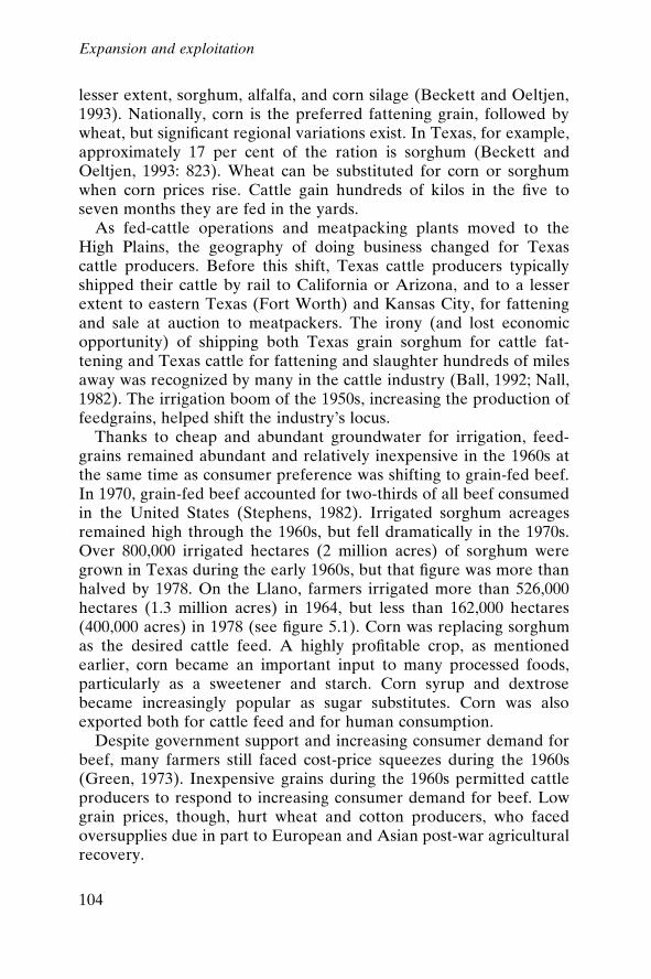
lesser extent, sorghum, alfalfa, and corn silage (Beckett and Oeltjen,1993). Nationally, corn is the preferred fattening grain, followed bywheat, but signi®cant regional variations exist. In Texas, for example,approximately 17 per cent of the ration is sorghum (Beckett andOeltjen, 1993: 823). Wheat can be substituted for corn or sorghumwhen corn prices rise. Cattle gain hundreds of kilos in the ®ve toseven months they are fed in the yards.
As fed-cattle operations and meatpacking plants moved to theHigh Plains, the geography of doing business changed for Texascattle producers. Before this shift, Texas cattle producers typicallyshipped their cattle by rail to California or Arizona, and to a lesserextent to eastern Texas (Fort Worth) and Kansas City, for fatteningand sale at auction to meatpackers. The irony (and lost economicopportunity) of shipping both Texas grain sorghum for cattle fat-tening and Texas cattle for fattening and slaughter hundreds of milesaway was recognized by many in the cattle industry (Ball, 1992; Nall,1982). The irrigation boom of the 1950s, increasing the production offeedgrains, helped shift the industry's locus.
Thanks to cheap and abundant groundwater for irrigation, feed-grains remained abundant and relatively inexpensive in the 1960s atthe same time as consumer preference was shifting to grain-fed beef.In 1970, grain-fed beef accounted for two-thirds of all beef consumedin the United States (Stephens, 1982). Irrigated sorghum acreagesremained high through the 1960s, but fell dramatically in the 1970s.Over 800,000 irrigated hectares (2 million acres) of sorghum weregrown in Texas during the early 1960s, but that ®gure was more thanhalved by 1978. On the Llano, farmers irrigated more than 526,000hectares (1.3 million acres) in 1964, but less than 162,000 hectares(400,000 acres) in 1978 (see ®gure 5.1). Corn was replacing sorghumas the desired cattle feed. A highly pro®table crop, as mentionedearlier, corn became an important input to many processed foods,particularly as a sweetener and starch. Corn syrup and dextrosebecame increasingly popular as sugar substitutes. Corn was alsoexported both for cattle feed and for human consumption.
Despite government support and increasing consumer demand forbeef, many farmers still faced cost-price squeezes during the 1960s(Green, 1973). Inexpensive grains during the 1960s permitted cattleproducers to respond to increasing consumer demand for beef. Lowgrain prices, though, hurt wheat and cotton producers, who facedoversupplies due in part to European and Asian post-war agriculturalrecovery.
Expansion and exploitation
104
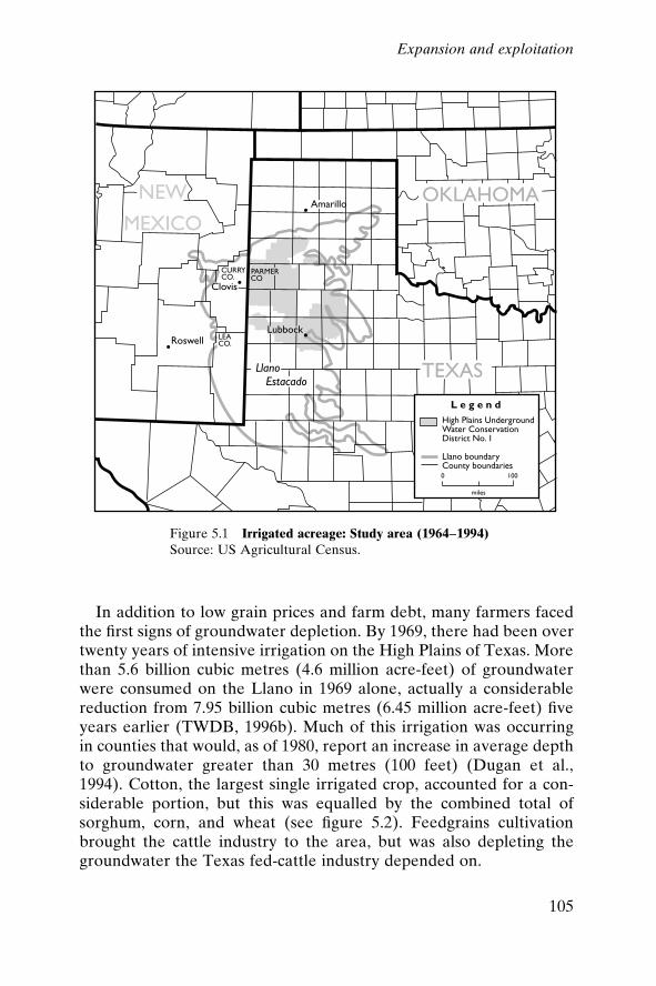
In addition to low grain prices and farm debt, many farmers facedthe ®rst signs of groundwater depletion. By 1969, there had been overtwenty years of intensive irrigation on the High Plains of Texas. Morethan 5.6 billion cubic metres (4.6 million acre-feet) of groundwaterwere consumed on the Llano in 1969 alone, actually a considerablereduction from 7.95 billion cubic metres (6.45 million acre-feet) ®veyears earlier (TWDB, 1996b). Much of this irrigation was occurringin counties that would, as of 1980, report an increase in average depthto groundwater greater than 30 metres (100 feet) (Dugan et al.,1994). Cotton, the largest single irrigated crop, accounted for a con-siderable portion, but this was equalled by the combined total ofsorghum, corn, and wheat (see ®gure 5.2). Feedgrains cultivationbrought the cattle industry to the area, but was also depleting thegroundwater the Texas fed-cattle industry depended on.
Figure 5.1 Irrigated acreage: Study area (1964±1994)Source: US Agricultural Census.
Expansion and exploitation
105
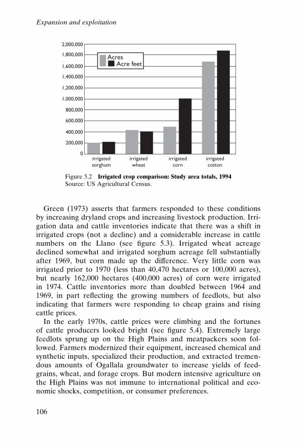
Green (1973) asserts that farmers responded to these conditionsby increasing dryland crops and increasing livestock production. Irri-gation data and cattle inventories indicate that there was a shift inirrigated crops (not a decline) and a considerable increase in cattlenumbers on the Llano (see ®gure 5.3). Irrigated wheat acreagedeclined somewhat and irrigated sorghum acreage fell substantiallyafter 1969, but corn made up the difference. Very little corn wasirrigated prior to 1970 (less than 40,470 hectares or 100,000 acres),but nearly 162,000 hectares (400,000 acres) of corn were irrigatedin 1974. Cattle inventories more than doubled between 1964 and1969, in part re¯ecting the growing numbers of feedlots, but alsoindicating that farmers were responding to cheap grains and risingcattle prices.
In the early 1970s, cattle prices were climbing and the fortunesof cattle producers looked bright (see ®gure 5.4). Extremely largefeedlots sprung up on the High Plains and meatpackers soon fol-lowed. Farmers modernized their equipment, increased chemical andsynthetic inputs, specialized their production, and extracted tremen-dous amounts of Ogallala groundwater to increase yields of feed-grains, wheat, and forage crops. But modern intensive agriculture onthe High Plains was not immune to international political and eco-nomic shocks, competition, or consumer preferences.
Figure 5.2 Irrigated crop comparison: Study area totals, 1994Source: US Agricultural Census.
Expansion and exploitation
106

In 1973, beef prices were at an all-time high when ``energy-food-currency shocks'' (McMichael, 1992) rocked the US economy. Energyprices, and therefore groundwater pumping costs, jumped overnight.Irate consumers organized meat boycotts and President Nixon re-sponded by freezing beef prices. The Soviet Union had just enduredtwo disappointing harvests and a major grain deal had been struckin 1972 with the Nixon administration. As grain supplies dwindledthrough increased exports and decreased production, and pricesclimbed, grain-fed cattle producers faced rising costs. Manyresponded by liquidating their cattle stock in order to avoid payingfor grain to fatten them. Recreating conditions of barely a centuryearlier, this rush to the market sent cattle prices tumbling. Averagemonthly prices for Amarillo Feeder steers (320±365 kilos or 700±800pounds) fell from US$58.73 per hundredweight in August, 1973 (anall-time high) to below $30.00 in October, 1974, a mere 14 monthslater (Davis et al., 1994: 63).13 Cattle inventories on High Plainsfeedlots also plummeted by almost half, from 1,686,000 in 1974 toonly 909,000 in 1975 (Nall, 1982). This rapid and large-scale liquida-tion forced many feedlots out of business; the number of feedlots innorth-west Texas with a capacity of 1,000 head or more dropped from118 in 1973 to only 89 in 1977 (ibid.).
This cyclical pattern of cattle price increases followed by a rapiddecrease is well known in the industry. A ``cattle cycle,'' thought to
Figure 5.3 Cattle inventory: Study area (1954±1993)Source: US Agricultural Census.
Expansion and exploitation
107
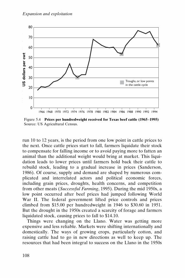
run 10 to 12 years, is the period from one low point in cattle prices tothe next. Once cattle prices start to fall, farmers liquidate their stockto compensate for falling income or to avoid paying more to fatten ananimal than the additional weight would bring at market. This liqui-dation leads to lower prices until farmers hold back their cattle torebuild stock, leading to a gradual increase in prices (Sanderson,1986). Of course, supply and demand are shaped by numerous com-plicated and interrelated actors and political economic forces,including grain prices, droughts, health concerns, and competitionfrom other meats (Successful Farming, 1995). During the mid 1950s, alow point occurred after beef prices had jumped following WorldWar II. The federal government lifted price controls and pricesclimbed from $15.00 per hundredweight in 1946 to $30.60 in 1951.But the drought in the 1950s created a scarcity of forage and farmersliquidated stock, causing prices to fall to $14.10.
Things were changing on the Llano. Water was getting moreexpensive and less reliable. Markets were shifting internationally anddomestically. The ways of growing crops, particularly cotton, andraising cattle had to go in new directions as well to keep up. Theresources that had been integral to success on the Llano in the 1950s
Figure 5.4 Prices per hundredweight received for Texas beef cattle (1965±1995)Source: US Agricultural Census.
US
do
lla
rsp
er
cw
t
Expansion and exploitation
108
and 1960s were undergoing transformations that echoed the evolu-tion of the new environment on the Llano half a century before.
Notes
1. This echoed a popular sentiment earlier in the century that there was in fact an``Underground River,'' ``one of the largest systems in the United States . . .[which] starts in the melting snows of the Rockies, sinks below the surface and atthe urge of gravity, starts southeast . . . For hundreds of years this water has been¯owing under the plains on its way to the Gulf [of Mexico] and mankind knew itnot . . . Now that this subterranean pipeline is being tapped, the plainsmen . . .claim that they have the nearest ideal system of agriculture on earth'' (ZenasE. Black, 1914, cited in Bowden, 1977: 120).
2. One reason cited by the Court was the very mysterious nature of groundwater,so ``occult that its regulation was impossible'' (Cisneros, 1980).
3. Statement by T.L. Wright, a Plains farmer testifying at a hearing regarding theimplementation of a water management district on the Llano.
4. A series of editorials in the Floyd County Hesperian (16 January 1947) entitled``Ought to Have Dams'' and ``Not Too Big Dams'' raised the spectre of the StateBoard of Water Control eventually ``tak[ing] over the farmer's little irrigationout®ts and tell[ing] him what he can and can't do after it is too late.''
5. ``Texas Farmer Is Leading Nation in Home Comforts,'' Ralls Banner, 4 January1952.
6. Full-page newspaper advertisement sponsored by district supporters. The text ofthe advertisement was led by ``People of the High Plains of Texas know that thewater table is falling.''
7. Text of testimony at a hearing about the district's formation, reported in theAmarillo Daily News, 29 September 1951.
8. The key role HPa1 would play in the administration of the water imported tothe Llano was a prominent argument raised in the election of January 1967,which was called to allow three more counties the option of joining the district.A counter-argument was raised that if the water should actually ever beimported to the Llano, membership in the district would certainly not be thedeciding factor in who received the bene®t of the water. At an estimated cost (in1977 dollars) of $430 to $569 per 1,234 cubic metres (one acre-foot), this wasprobably true, as who would be able to afford the water would be the salientfactor (Urban, 1992).
9. Some areas have reported a drop of over three metres (10 feet, actually) in waterlevels at different times over the past 40 years.
10. In a scathing letter to the Executive Director of the Texas Water DevelopmentBoard from the manager of HPa1 Frank Rayner, and signed by the Board ofDirectors, this point was made emphatically. ``[I]t is obvious that the High Plains``leaders'' have already taken the ``institutional'' initiative,'' Mr Rayner states(letter dated 4 March 1974).
11. The current status of many farm programmes is uncertain. Sweeping changeswere enacted in the 1995±96 US legislative session; the impacts have yet to berealized. Price support programmes have been eliminated and crop subsidies,
Expansion and exploitation
109
so-called de®ciency payments, are being phased out over a period of sevenyears.
12. The futures market was projecting a price of $2.50±$2.60/bushel for wheat inJanuary 2000. Prices projected for wheat in January of 1955 were about $2.05/bushel. These ®gures are futures-based and not adjusted for in¯ation; neverthe-less a comparison of inputs in unadjusted ®gures helps tell the story. Energyprices in late 1999 to early 2000 average around $1.40/gallon for gasoline, a basicinput for running farm machinery, compared to roughly $0.25/gallon in the1950s. (In the United States, one bushel equals 35.3 (American dry measure) andone gallon equals 3.79 litres.)
13. In the United States, one hundredweight equals 100 pounds (about 45.5 kg).
Expansion and exploitation
110
6
The transformation of theLlano in the post-expansionera: 1980 to the present
Ominous contraction followed the post-war years of unanticipatedgrowth and expansion on the Llano. The limits of the groundwatersupply were ®rst ignored and then undeniably obvious, as depths towater increased rapidly over the years of the late 1970s and 1980s.The impacts of this were felt by cotton growers and cattle producers,and by the rest of the Llano's residents as well. Shifts in strategiesand changes in practices, prompted by weather and markets, havemarked the recent decades on the Llano. The future has also changedbecause of the reality of the water; what the Euro-American settlersimagined and the successes of the post-war era portended has beentempered by that reality.
Cotton on the post-expansion Llano
Today, cotton production pumps an estimated US$2.5 billion into theregional economy of the Llano, according to Eduardo Segarra, anagricultural economist at Texas Tech University in Lubbock. Llanofarmers grow 60 per cent of the cotton produced in Texas, 15 per centof the cotton grown in the United States, and 3.5 per cent of theworld cotton crop. This gives the region the largest concentration ofcotton production in the world (Daniel, 1995a: 3). Given that irriga-
111
tion of the crop places one of the biggest demands on the aquifersystem, cotton production has been a major driving force of environ-mental degradation or resource depletion. Globally and historicallyembedded and locally adapted, the production of cotton is a primaryforce in shaping the region's current economic and environmentalstatus. The global market for cotton affords both signi®cant oppor-tunities and constraints for local producers dependent upon non-renewable groundwater.
The global cotton market
Cotton has been grown on the Llano since the beginning of thetwentieth century. Through the 1920s, cotton was a dryland crop (inthe 1930s virtually all crops grown on the Llano were dryland farmedby default). After World War II, cotton started to emerge as a majorcash crop, thanks to the sustained high yields made possible by irri-gation. The overuse of water throughout that period of expansion ledto the restrictions of the 1970s and 1980s. But the developments oftechnology and enterprise that occurred more than a hundred yearsago during the industrial revolution were as much precipitators oftoday's water crisis in the Llano Estacado as were the farmers whosettled the area. Indeed, the legacy of cotton is long and rich, fraughtwith the best and the worst of human character and action. Slavery inthe American South, persecution and liberation of women and chil-dren in the textile mills, technological discovery, and the ``rise of thefactory'' are just a few of the elements linked to the rise of cottonas a principal commodity crop and ®bre (see for example Harevenand Langenbach, 1978; Wright, 1978; Genovese, 1965; Young, 1903;Robinson, 1898). In fact, ``King Cotton'' and the textile industry werea fundamental part of the ®rst industrial revolution and, along withother elements, led to the integrated world market that was largely inplace by 1914.
At the end of the eighteenth century, cotton accounted for only5 per cent of global textile consumption; by 1890, its share was over80 per cent. For more than a century, the international division oflabour involved the demarcation between raw cotton producers inthe colonial and semi-colonial regions and industrial processors in thecentre. Major deviations from this simple schematization existed,however. For example, the United States was one of the largest cottonproducers and exporters long after it had become a central industrialeconomy with a major textile and clothing industry ± in fact, the
The post-expansion era
112
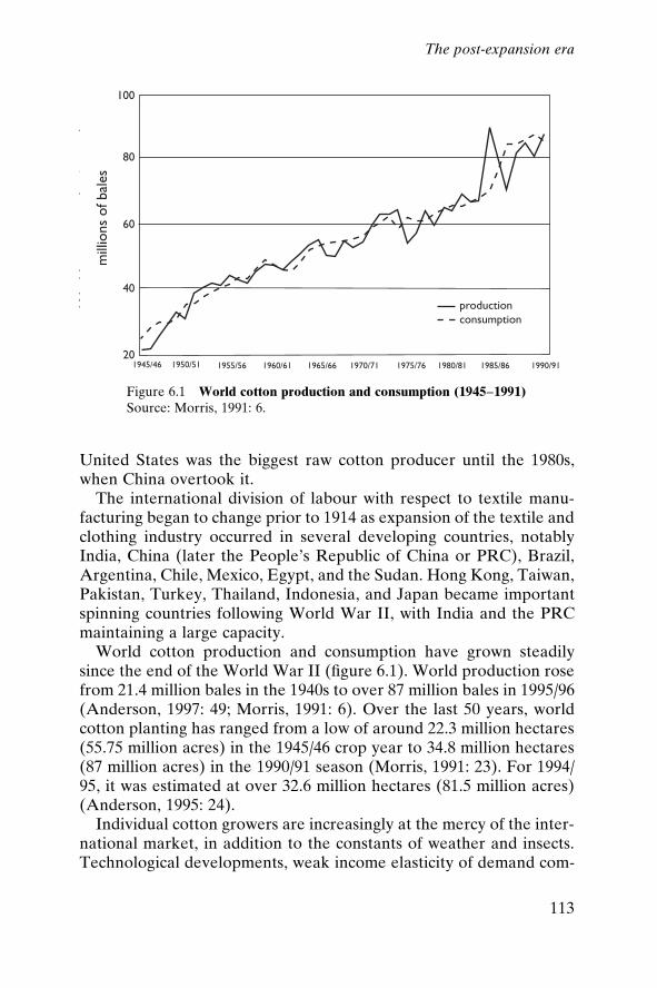
United States was the biggest raw cotton producer until the 1980s,when China overtook it.
The international division of labour with respect to textile manu-facturing began to change prior to 1914 as expansion of the textile andclothing industry occurred in several developing countries, notablyIndia, China (later the People's Republic of China or PRC), Brazil,Argentina, Chile, Mexico, Egypt, and the Sudan. Hong Kong, Taiwan,Pakistan, Turkey, Thailand, Indonesia, and Japan became importantspinning countries following World War II, with India and the PRCmaintaining a large capacity.
World cotton production and consumption have grown steadilysince the end of the World War II (®gure 6.1). World production rosefrom 21.4 million bales in the 1940s to over 87 million bales in 1995/96(Anderson, 1997: 49; Morris, 1991: 6). Over the last 50 years, worldcotton planting has ranged from a low of around 22.3 million hectares(55.75 million acres) in the 1945/46 crop year to 34.8 million hectares(87 million acres) in the 1990/91 season (Morris, 1991: 23). For 1994/95, it was estimated at over 32.6 million hectares (81.5 million acres)(Anderson, 1995: 24).
Individual cotton growers are increasingly at the mercy of the inter-national market, in addition to the constants of weather and insects.Technological developments, weak income elasticity of demand com-
Figure 6.1 World cotton production and consumption (1945±1991)Source: Morris, 1991: 6.
The post-expansion era
113
pared with manufacturing, government supports in many countries,high ratios of carryover stocks, and other factors have tended tokeep the price of cotton low relative to those of manufacturedproducts. Like the prices of many other industrial raw materials(Radetzki, 1990), cotton prices have tended to trend downwards inreal terms. By the end of the 1980s, real value prices were only a thirdof what they were in 1945/46 (Morris, 1991: 6). Wide price ¯uctua-tions, another characteristic of most commodities, are expected toincrease for cotton as deregulation and liberalization continue apace.
Production varies considerably from year to year. Cotton is a cropthat produces high value per hectare, is non-perishable, has lowweight to volume for transport, and can survive drought to somedegree. Many countries depend upon it for foreign exchange andhave tried expanding its production over the years. Farmers in theUnited States and elsewhere increase cotton acreage when the pricegoes up. The crop is also susceptible to damage from insects andrusts, and can be affected dramatically by climatic variability. Allthese factors, in combination with technological advances, the pricesof other crops, government policies, and the prices of inputs, create¯ux in production.
Yields roughly correspond to inputs, which are, in turn, roughlyre¯ected in costs of production. These vary considerably dependingon farm size, level of mechanization (including whether cotton isseeded and picked by hand or by machine), irrigation method used,quality of chemicals applied and variety grown. In the United States,where the average cost of production was US$1,137/ha ($460/acre) in1988, costs can vary from a low of $568/ha ($230/acre) in the southernplains to $1,977/ha ($800/acre) in the far west (International CottonAdvisory Committee, 1988).
World cotton production is not expected to increase much in themedium-term future. Cotton is a relatively high-risk crop and manyUS growers, in the absence of price supports and subsidies, are un-willing to plant it, especially when other commodity crop prices areattractive. Furthermore, in many countries, cotton competes withfood crops for land, constraining its expansion; current technology islikely to result in only modest gains in cotton yields in the near term.
Cotton exports and trade
Cotton has been traded internationally for over two centuries. In1850, nearly 90 per cent of US cotton was exported, with earnings
The post-expansion era
114

equal to about two-thirds of all goods imported into the country(Sanford, 1990). In 1988, almost 40 per cent of US cotton wasexported, with earnings equal to less than 0.5 per cent of all goodsimported into the United States. Even so, the US cotton trade gen-erates a surplus of nearly $2 billion. The grower's pro®t, once thecotton is brought to market, depends upon the dollar exchange rate,cotton production in other countries, import and export policies ofother countries, existing surpluses or stocks worldwide, and thedemand for cotton.
Approximately 30 per cent of world cotton production is tradedinternationally. Over the past three decades, as output has expanded,so has the volume of raw ®bre traded. Table 6.1 provides an estimateof the trading volumes for major cotton producing countries. Six ofthe largest transnational corporations account for between 85 and90 per cent of internationally traded cotton, usurping the growers'in¯uence in the trading circle (Maizels, 1992). The cotton grower'sprice to the trader represents only 4±8 per cent of the ®nal product(cotton clothing) price (Maizels, 1992: 164).
Most of the Llano cotton crop (60±70 per cent) is exported for usein making lesser quality yarns typical of those used in the denimmarket. In effect, the Llano competes with Pakistan, Uzbekistan,the PRC, and other areas that grow cotton of a similar quality.Reliability (of delivery and quality) is one of the big competi-tive advantages the region has vis-aÁ -vis its competitors. The NorthAmerican Free Trade Agreement is expected to bene®t Texas grow-ers over the long term because cotton can be delivered to Mexicanmills quickly and ef®ciently. In addition, new mills are being plannedfor state-of-the-art cotton spinning in Texas. Whether these newopportunities will aid the region's cotton growers is uncertain, pri-marily because the costs of production have edged upward over thelast few years. The region went from having relatively low-cost cottonproduction in the 1970s to high-cost cotton production by 1985(Bednarz and Ethridge, 1990).
These increases in production costs (including higher irrigationoutlays), along with greater competition in the global market andgovernment deregulation, have caused a continued decline in thenumber of area farms and in farm sales (see ®gures 1.2, p. 16, and6.2). Average farm size tended to grow a bit in some counties but, forthe most part, stayed relatively constant from the 1970s to mid-1990s(see ®gures 6.3 and 6.4). The downturn or cost±price squeezeprompted many Llano farmers to go to a combination of tillage
The post-expansion era
115
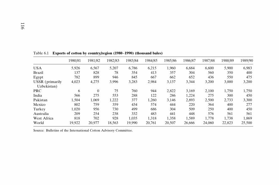
Table 6.1 Exports of cotton by country/region (1980±1990) (thousand bales)
1980/81 1981/82 1982/83 1983/84 1984/85 1985/86 1986/87 1987/88 1988/89 1989/90
USA 5,926 6,567 5,207 6,786 6,215 1,960 6,684 6,600 5,900 6,983Brazil 137 828 78 354 413 357 304 560 350 400Egypt 782 899 946 845 667 662 652 436 550 475USSR (primarily
Uzbekistan)4,023 4,275 3,996 3,283 2,984 3,137 3,344 3,200 3,000 3,200
PRC 6 0 75 760 944 2,822 3,169 2,100 1,750 1,750India 566 275 553 288 122 286 1,224 275 300 450Pakistan 1,504 1,069 1,222 377 1,260 3,146 2,893 2,500 2,733 3,300Mexico 802 759 359 434 574 444 220 364 400 277Turkey 1,020 956 730 499 686 304 509 250 400 450Australia 209 254 238 332 483 441 448 576 561 561West Africa 818 702 928 1,035 1,318 1,358 1,589 1,778 1,738 1,869World 19,922 20,977 18,563 19,990 20,761 20,507 26,666 24,060 22,823 25,500
Source: Bulletins of the International Cotton Advisory Committee.
116
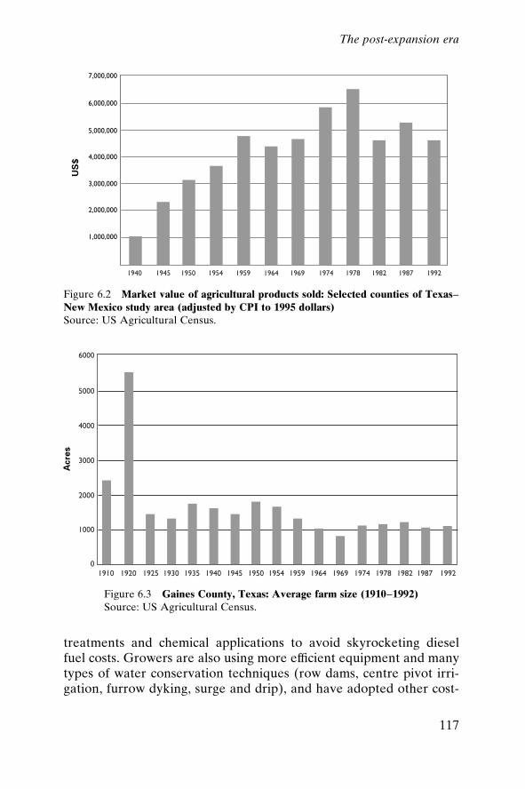
treatments and chemical applications to avoid skyrocketing dieselfuel costs. Growers are also using more ef®cient equipment and manytypes of water conservation techniques (row dams, centre pivot irri-gation, furrow dyking, surge and drip), and have adopted other cost-
Figure 6.2 Market value of agricultural products sold: Selected counties of Texas±New Mexico study area (adjusted by CPI to 1995 dollars)Source: US Agricultural Census.
Figure 6.3 Gaines County, Texas: Average farm size (1910±1992)Source: US Agricultural Census.
Acre
sU
S$
The post-expansion era
117
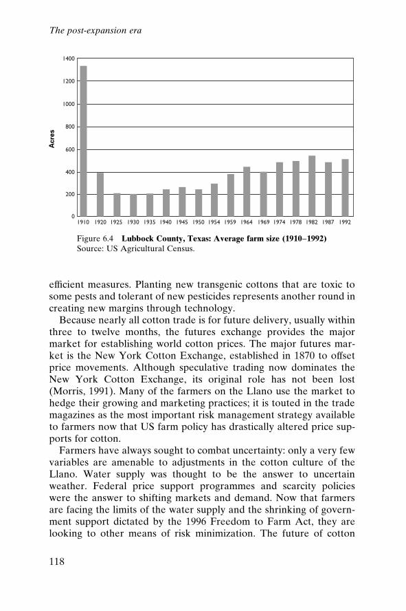
ef®cient measures. Planting new transgenic cottons that are toxic tosome pests and tolerant of new pesticides represents another round increating new margins through technology.
Because nearly all cotton trade is for future delivery, usually withinthree to twelve months, the futures exchange provides the majormarket for establishing world cotton prices. The major futures mar-ket is the New York Cotton Exchange, established in 1870 to offsetprice movements. Although speculative trading now dominates theNew York Cotton Exchange, its original role has not been lost(Morris, 1991). Many of the farmers on the Llano use the market tohedge their growing and marketing practices; it is touted in the trademagazines as the most important risk management strategy availableto farmers now that US farm policy has drastically altered price sup-ports for cotton.
Farmers have always sought to combat uncertainty: only a very fewvariables are amenable to adjustments in the cotton culture of theLlano. Water supply was thought to be the answer to uncertainweather. Federal price support programmes and scarcity policieswere the answer to shifting markets and demand. Now that farmersare facing the limits of the water supply and the shrinking of govern-ment support dictated by the 1996 Freedom to Farm Act, they arelooking to other means of risk minimization. The future of cotton
Figure 6.4 Lubbock County, Texas: Average farm size (1910±1992)Source: US Agricultural Census.
Acre
s
The post-expansion era
118
cultivation on the Llano is dependent on their success. Yet USgrowers are much better disposed toward dealing with the uncer-tainties of a global market than are growers from many developingcountries. US growers are more sophisticated in terms of marketing,and they have at their ®ngertips a considerable technological andinformational infrastructure. So, for the groundwater aquifer, theimplications of deregulation are not necessarily positive. Water levelsthat held steady or rose over the lean years of the 1980s have, in the1990s, declined again because of the continuing demand and rela-tively good prices for cotton. With both dryland and irrigated cottontechnology and cultural practices improving, cotton will most likelycontinue to play a major role in the economy of the Llano Estacado.
Cattle on the post-expansion Llano
Fluctuations in the fortunes and prospects of cattle producers on theLlano were not dampened by the transition to an era that has beende®ned by the limits of irrigation and roiling international markets.The 1974 drop in cattle prices signalled the start of a major agricul-tural restructuring. The impacts of the ``energy-food-currency shocks''(McMichael, 1993) that hit the US economy were compounded by anincreasing health consciousness among US consumers. Consumersshifted their meat preference toward mass-produced and inexpensivepoultry, apparently at the expense of beef. US consumption of beeffell nearly 30 per cent from 1976 to 1990, from a per capita con-sumption rate of 42.9 kilos (94.5 pounds) in 1976 to around 30 kilos(about 66 pounds) through the 1990s (Brooke, 1996; Ufkes, 1995).Declining demand combined with falling pro®ts led to a series of in-dustry restructurings designed to regain producers' competitivenessthrough economies-of-scale ef®ciencies and reduction in costs. Themost important change in the meatpacking industry was the contro-versial meatpacking consolidations of the 1970s and 1980s.
Consolidation
A ¯urry of new players and consolidated old players emerged fromthese consolidations. IBP (formerly called Iowa Beef Packers) be-came the most important company heralding the post-1973 beef in-dustry restructuring. Meatpacking competitors became larger, fewerin number, and increasingly vertically integrated, as well (Purcell,1990a). Old and familiar names in the meatpacking industry such as
The post-expansion era
119
Swift, Wilson, Hormel, and Armour became subsumed under large,international food conglomerates. ConAgra purchased Monfort andSwift Independent in 1987. Cargill, the world's largest grain trader,purchased Excel and Caprock industries. The concentration amongthe ``Big Three'' (IBP, Cargill, and ConAgra) or ``Big Four'' (ifNational Beef is included) reached 69.7 per cent of market share in1988. In 1989, the Big Four accounted for 80.8 per cent of all cattlepurchases made that year (Ward, 1990). In 1975, when restructuringbegan, the four largest ®rms had accounted for only 25 per cent ofbeef production (Ufkes, 1995).
Few can argue with the increased ef®ciency of the consolidatedand high-volume packing plants. Costs of cattle slaughter fall withincreasing size of operation and there are indications that theincreased ef®ciencies permitted packers to respond to economicchanges in the market more quickly (Purcell, 1990b). In 1995, Exceland IBP, which handled more than 93 per cent of all cattle slaugh-tered on the Llano, had annual slaughter capacities of 1 million and1.76 million respectively. Five other packing plants exist on the Llano,but combined they account for less than 7 per cent of the area'sslaughter capacity.
Similarly, feedlots or feedyards have increased their capacities tophenomenal levels. In Texas, in 1995, forty feedyards had a capacityin excess of 32,000 animals and another 29 had capacities between16,000 and 31,999. These feedyards marketed 4.67 million cattle in1995, or 84.2 per cent of all fed-cattle sold (NASS, 1996). Since theheart of the fed-cattle industry (Deaf Smith, Castro, and Parmercounties) lies on the Llano, the numbers are similar. Of the 1.7 mil-lion animal feedlot capacity, all but 109,000 head is in feedlots withcapacities of 16,000 or greater.
As packers built high-volume plants for ef®ciency, their need for aconstant, steady supply of quality cattle sparked further vertical inte-gration. A practice already prevalent in poultry farming (both eggsand meat) and dairy processing, vertical integration refers to theconsolidation of two or more steps in the commodity production ordistribution process by a single company (Goldschmidt, 1978). Verti-cal integration can be accomplished through single ownership of allsteps of a process by a corporation or through contract farming. Withcontract farming, a processor, marketer, or feed-supply house con-tracts with individual farmers to produce certain levels of commod-ities at a set price established in advance of the harvest or, in the caseof livestock, before shipping to slaughterhouses (Goldschmidt, 1978).
The post-expansion era
120
Through the 1970s, most cattle were bid on by packers at publicauctions. Cattle prices were driven up during high demand and drivendown with oversupplies. But industrial restructuring meant the demiseof public auctions and the rise of direct feedlot purchases. In 1960,only 39 per cent of cattle were sold directly from feedlots to packers(Ufkes, 1995), but by 1989 over 90 per cent were direct purchases(Ward, 1990). Most cattle on the Southern High Plains are sold onthe cash market. Increasingly, however, packers have bypassed cashmarket purchases and have turned to ``captive supplies'' to meet theirneed for a constant and steady supply of quality cattle.1 ``Captivesupplies'' refers to any number of relationships that remove cattlefrom competitive bidding. Forward contracts, packer-fed cattle, andformula purchases are the most common forms of captive supplies.2These arrangements ensure a steady supply of quality-controlledcattle, increasing ef®ciency for high-volume packing plants, whichlose money when kill rates fall much below capacity.
Cattle producers on the Llano remain wary of the market powersuch extreme industrial concentration gives to packers. Only fourcompanies make over 80 per cent of all cattle purchases nationally;this is probably an even higher percentage regionally. Producersworry that this concentrated power depresses cattle prices, particu-larly through captive supplies, although no hard evidence exists tosupport this concern (Ward, 1990: 101). However, industry analystsconsider the use of captive supplies threatening to base price devel-opment because public information is limited and public agencies areunable to inform the producer suf®ciently (Purcell, 1990b).
Meatpacker arguments and statistical evidence to the contraryhave not convinced most cattle producers, either. For example, pro-ducers cite the fact that IBP made pro®ts of around $256 million in1995 (Brooke, 1996) while thousands of producers declared bank-ruptcies or liquidated all of their stock. The question remains largelyunanswered: are prices simply determined by relative supply and de-mand and quality, and is the current crisis just a low point in thecattle cycle?
Additionally, the US Department of Agriculture studies inves-tigating cattle producers' pricing complaints reported that livestockoperations and processing plants have created considerable localgroundwater pollution. These same studies echoed the sentiments ofthe small rural communities in the Midwest and Great Plains. Meat-packing plants used to provide middle-class wages, but, with lowwages, considerable demand on community infrastructure, and the
The post-expansion era
121
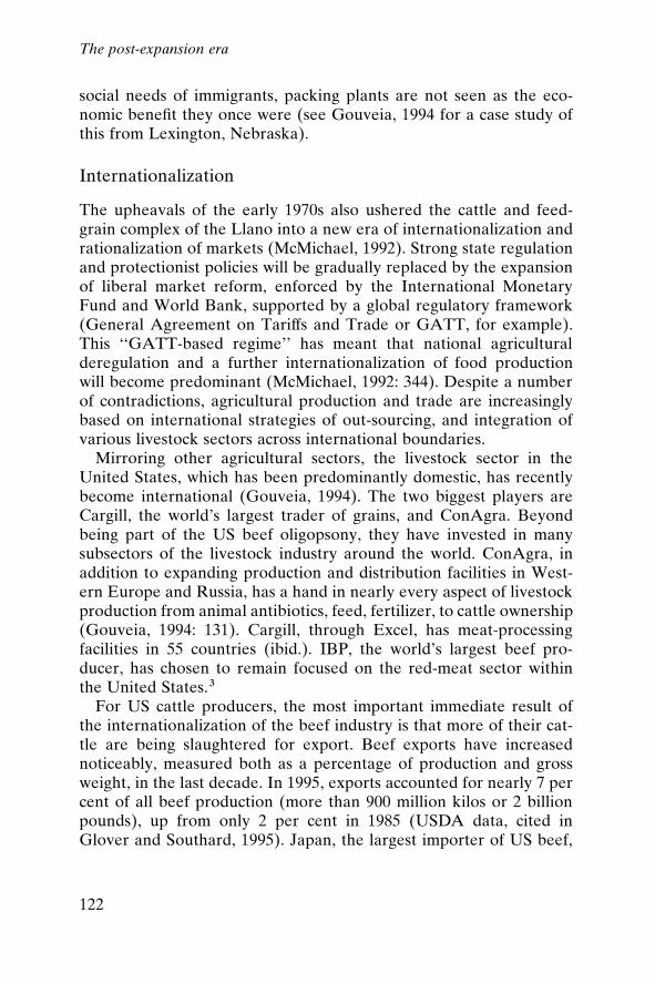
social needs of immigrants, packing plants are not seen as the eco-nomic bene®t they once were (see Gouveia, 1994 for a case study ofthis from Lexington, Nebraska).
Internationalization
The upheavals of the early 1970s also ushered the cattle and feed-grain complex of the Llano into a new era of internationalization andrationalization of markets (McMichael, 1992). Strong state regulationand protectionist policies will be gradually replaced by the expansionof liberal market reform, enforced by the International MonetaryFund and World Bank, supported by a global regulatory framework(General Agreement on Tariffs and Trade or GATT, for example).This ``GATT-based regime'' has meant that national agriculturalderegulation and a further internationalization of food productionwill become predominant (McMichael, 1992: 344). Despite a numberof contradictions, agricultural production and trade are increasinglybased on international strategies of out-sourcing, and integration ofvarious livestock sectors across international boundaries.
Mirroring other agricultural sectors, the livestock sector in theUnited States, which has been predominantly domestic, has recentlybecome international (Gouveia, 1994). The two biggest players areCargill, the world's largest trader of grains, and ConAgra. Beyondbeing part of the US beef oligopsony, they have invested in manysubsectors of the livestock industry around the world. ConAgra, inaddition to expanding production and distribution facilities in West-ern Europe and Russia, has a hand in nearly every aspect of livestockproduction from animal antibiotics, feed, fertilizer, to cattle ownership(Gouveia, 1994: 131). Cargill, through Excel, has meat-processingfacilities in 55 countries (ibid.). IBP, the world's largest beef pro-ducer, has chosen to remain focused on the red-meat sector withinthe United States.3
For US cattle producers, the most important immediate result ofthe internationalization of the beef industry is that more of their cat-tle are being slaughtered for export. Beef exports have increasednoticeably, measured both as a percentage of production and grossweight, in the last decade. In 1995, exports accounted for nearly 7 percent of all beef production (more than 900 million kilos or 2 billionpounds), up from only 2 per cent in 1985 (USDA data, cited inGlover and Southard, 1995). Japan, the largest importer of US beef,
The post-expansion era
122
accounted for more than 50 per cent of US exports in 1994. OtherPaci®c Rim countries, especially Korea, are targeted by the beefindustry for increased exports. Beef imports, now nearly equal toexports on a tonnage basis, have been limited since 1980 due to ameat import law. The US tonnage trade de®cit is predicted to de-crease further if imports continue to decrease (as they have since1993) and as exports increase. (On a value basis, the United Stateshas been a net exporter since 1991.)
Cattle producers, feedlot owners, meatpackers, and the USDA allapplaud this trend of expanding US beef exports. And continuedinternational expansion may help alleviate depressed cattle prices atlow points in the cattle cycle. New markets for US beef, like Japan,which opened to the United States in 1988, have had profoundimpacts on agro-industrial investments. US cattle feeders alteredtheir fattening procedures and meatpackers built processing plantsdesigned to accommodate Japanese tastes (Ufkes, 1993: 226). Japa-nese investors quickly purchased feedlots and meatpacking plants inthe United States; their overall share of the market remains limited,however. Interestingly, US grain producers (who in Texas are usuallyalso the cattle producers) objected to forcing Japan to liberalize itsbeef market because Japan was purchasing US grain for their ownfed-cattle.4
The cattle cycle downturn in the mid 1990s served to remind pro-ducers how vulnerable they are to the global market and the climateas well. Cattle prices began falling in 1994 and plummeted in 1996.Cattle producers were hit hard for several reasons. First, many econ-omists perceive a classic case of oversupply as the industry enters alow price phase in the cattle cycle; this was clearly true in the mid1990s. Producers received relatively high prices in 1992 and 1993when supply was tight, but in 1994 the number of cattle had increasedto its highest level since 1986 (nearly 104 million head) and pricesdropped precipitously. Texas producers earned on average $75.60 perhundredweight in 1993; that price fell to $62.20 in 1995 (NASS, 1996).The price fell further to the mid to upper $50 range in 1996. Second,producers would not necessarily sell off their herds in reaction solelyto falling prices unless grain prices were also high. Prices for grain,particularly corn and sorghum used to fatten cattle before sale,increased as rapidly as cattle prices fell. For example, corn that soldfor under $2.00 per bushel at the end of 1994 increased to $4.99 byMay, 1996 before falling again late in 1996. With high grain prices,
The post-expansion era
123
producers would typically run their cattle on wheat to graze untilgrain prices fell, but that was not possible owing to the third mostimportant reason, a prolonged drought.
The impacts on the Llano from the mid 1990s drought were wide-spread and harsh. Farmers in Oklahoma and Texas resorted toploughing under winter wheat crops because the expense of harvest-ing the crop would not justify the meagre yields. With grain priceshigh and cattle prices low, it was costing farmers more to fatten cattlethan the extra weight was worth. Massive herd liquidation ensuedand the national herd total was estimated to have fallen by at least 2million in 1996 (Feder, 1996). The Oklahoma Agriculture Commis-sioner estimated that between 5,000 and 10,000 farming families (outof only 70,000) have been forced to declare bankruptcy as a result(Verhovek, 1996). By the end of 1996, many farmers in CastroCounty, Texas, had not harvested dryland wheat for ®ve years (Rag-land, 1996) and Randall county cattle herds were at 15 to 20 per centof their normal levels. Because the drought persisted for severalyears, some farmers, anticipating continued drought conditions,planted more dryland crops (Hacker, 1996). Cattle producers try toride out the low point in the cattle cycle until cattle supplies are low-ered and prices once again move upwards. The overriding concernfor most producers is simply one of short-term survival. But on theLlano, a signi®cant subgroup ± grain farmers with irrigation ± willalways stand to bene®t in the short term.
Water consumption and groundwater depletion
The combination of the mid-1990s drought and high grain and cottonprices prompted many irrigators to pump tremendous amounts ofgroundwater to irrigate crops. In 1994 alone, groundwater levels fellon average by 0.6 metres (2 feet) or more in seven HPa1 counties(HPUWCD a1, 1996a). The largest declines were in Lubbock andHale, two counties dominated by cotton cultivation. Cotton was thesingle largest irrigated crop on the Llano, accounting for 676,000irrigated hectares (1.67 million acres) and 2.3 billion cubic metres ofwater (1.86 million acre-feet) in 1994 (see ®gure 6.5). Most irrigationoccurs within a seven-county area surrounding and including Lub-bock. But the farther north and west one goes from Lubbock, the lesscotton and the more grain crops are grown. The three main graincrops, sorghum, corn, and wheat, accounted for over 450,000 irrigatedhectares (1.12 million acres) and consumed 2 billion cubic metres of
The post-expansion era
124
water (1.63 million acre-feet). All, or nearly all, of the sorghum andmost of the corn crop is destined for cattle feed. Some corn in thearea, particularly in Hale and Castro counties, is sold to the nearbyFrito Lay processing plant. The production from less than about200,000 hectares of corn (500,000 acres) and nearly 40,500 hectares(about 100,000 acres) of sorghum is not enough to feed the more than3 million cattle on the Llano.
The Southern High Plains attracted feedlots with its ample feed-grains and cattle, but its success at retaining the feedlot industry andattracting the meatpacking industry has meant that cattle producersfrom hundreds of miles away send their cattle to the Southern HighPlains for grazing, fattening, and ultimately slaughter. Grain produc-tion has not kept pace, and much of the corn used to feed cattle isimported from other plains states or the corn belt of the Midwest.Nevertheless, much of the local grain production is irrigated from theOgallala, and many counties have watched their average depth togroundwater increase by over 6 metres (20 feet). Cotton may be themost important consumer of irrigated water, but irrigated grains andsilage for cattle have contributed substantially also, particularly in thenorthern half of the Llano.
Since the 1940s, some of the greatest groundwater depletion hasoccurred in the very heart of the fed-cattle industry (Deaf Smith,Parmer, and Castro counties). By 1980, the average depth to ground-water had increased by more than 30 metres (100 feet) in parts of atleast seven counties, most notably in Parmer, Castro, Hale, and Floyd(Dugan et al., 1994). Since 1970, Parmer and Castro counties have
Figure 6.5 Irrigated acreage: Study area (1964±1994)Source: US Agricultural Census.
The post-expansion era
125
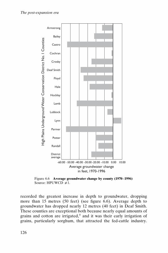
recorded the greatest increase in depth to groundwater, droppingmore than 15 metres (50 feet) (see ®gure 6.6). Average depth togroundwater has dropped nearly 12 metres (40 feet) in Deaf Smith.These counties are exceptional both because nearly equal amounts ofgrains and cotton are irrigated,5 and it was their early irrigation ofgrains, particularly sorghum, that attracted the fed-cattle industry.
Figure 6.6 Average groundwater change by county (1970±1996)Source: HPUWCD a1.
The post-expansion era
126
(This trend is also true of Swisher County, but there are no ground-water data available.) In 1958, nearly 98,750 hectares (244,000 acres)and more than 68,000 hectares (168,000 acres) of sorghum were irri-gated in Parmer and Castro counties respectively.6 Given the highlevels of irrigation this early, it is no wonder that many people havereached the limits of affordable groundwater, or have continuallyretooled their equipment to get the same amount of water. Irrigatedsorghum acreage has since declined considerably, but Parmer andCastro counties remain leading irrigators of sorghum.
The irrigated land-use ®gures indicate a diversi®ed irrigated land-scape. The land-use adjustment away from irrigated sorghum to irri-gated corn has impacts for groundwater consumption. Sorghum,imported to the area from Africa as a drought-resistant crop, is notnearly as water-demanding as corn. In 1994, corn irrigators on theLlano applied 2,529.7 cubic metres of water per hectare (2.05 acre-feet per acre) of High Plains Aquifer groundwater, but sorghum irri-gators applied only 1,370 cubic metres per hectare (1.11 acre-feet peracre) (TWDB, 1996b). Very little non-irrigated corn is planted, for agood reason; the Southern High Plains is too dry for such a thirstycrop. If current planting trends continue, correspondingly increasedgroundwater depletion can be expected.
Fed cattle in feedlots and meatpacking plants consume signi®cantamounts of groundwater as well, but far and away most of the waterconsumed by the feedgrain±cattle complex is used to grow feed-grains. On the Llano, meatpacking plants consumed 8.3 billion litres(2.2 billion US gallons) of water to slaughter about 3.5 million cattlein 1995.7 And nearly 3 million fed-cattle in feedlots consumed around34.4 billion litres of water (9.1 billion US gallons).8 In absolute terms,this is a considerable amount of water, but converted into irrigationmeasurements (cubic metres or acre-feet), the meatpacking industryconsumed only 8.3 million cubic metres (6,734 acre-feet) and feedlotsonly 34.6 million cubic metres (28,061 acre-feet) of water. Comparedto irrigation, this is nearly trivial: combined, this ®gure is about theamount used to irrigate grain sorghum in Deaf Smith county in 1994alone.
Determining the total water consumption of the feedgrain±cattlecomplex is dif®cult. Beckett and Oeltjen (1993) estimated that forevery kilogram of beef produced in the United States, 3,682 litres(981.9 US gallons) of water were consumed. (They determined thatregional disaggregations were not practical because feedgrains thatcontain water, in addition to being irrigated heavily, move con-
The post-expansion era
127
tinuously around the country.) This ®gure is likely to be considerablyhigher for the Llano because of the dry, hot conditions, causinggreater heat stress on cattle and greater reliance on irrigated feed-grains for fattening.
Implications for the regional economy
What does all this mean for the future for agriculture on the Llano,speci®cally cotton and the feedgrain±cattle complex? There is ampleevidence to allow us to conclude that in some places groundwaterdepletion has led to dryland farming. Emel and Roberts (1995) havenoted, from transects in several Llano counties, that there has been ashift from irrigated cropping to rangeland, winter wheat, drylandcrops, or idle land, chie¯y as a result of shallow soils and a loss ofsaturated thickness of the aquifer. Anecdotal information supportsthe idea that many farmers are switching to dryland crops (Forest,1996) because they can no longer afford to pump what water remainsbeneath their land. Some older farmers who have experienced theswitch to irrigation from dryland agriculture in the 1950s or 1960s arenow switching back to dryland crops as their available groundwater isdepleted (ibid.).
White (1994) cautions, however, that the entire Great Plains is notthe ``failed region'' some authors would have us believe. Rather, theGreat Plains is heterogeneous, and many areas have readily availableirrigation groundwater. If ``oases'' of development based in part onproximity to groundwater develop (or continue), as White predicts,what will happen to the cotton and feedgrain±cattle complex of theLlano Estacado? The answer to that is based on a number of factors,including the severity of groundwater depletion, affordable tech-nologies to extract and use groundwater ef®ciently, hybrid grainwater demands, and the spatial rootedness of the feedlot and meat-packing industries.
Feedgrains grown on the High Plains of Texas consume enormousamounts of water, but much of the grain fed to cattle on the feedlotsof the Llano now comes from the less irrigated Midwestern andnorthern plains states that have not depleted as much of their portionof the High Plains Aquifer groundwater. If less land can be affordablyirrigated on the Llano for feedgrains, will the feedlots and packingplants move back to the Midwest, or would such a move be prohib-itively expensive? Kromm and White (1992b) argue that more feed-grain crops will be grown in Nebraska and, consequently, feedlot ex-
The post-expansion era
128
pansion will occur there. Modern feedlots and meatpacking plants,however, represent such large investments that they are effectivelyimmobile. Meatpacking plants, it is also argued, would not move evenif feedlots expand in Nebraska because they are close enough(Kromm and White, 1992c: 225).
Amarillo may be a centre for economic growth in the future andthere probably will be ``oases'' of development on the southernplains, but it appears certain that fewer and fewer people will be liv-ing as farmers and ranchers. Each cattle cycle pushes more farmersand ranchers out of agriculture. This may produce an economicallyef®cient beef production system, but it may also mean a depopulationof the area as cattle inventories and grains are controlled by fewerpeople.
One unexplored possibility remains the so-called ``designer beef''market ± the demand for organically fed free-range cattle, whilesmall, has grown steadily over the past decade. Luxury markets, par-ticularly in Asia and Europe, are seen as likely consumers for theexpensive beef. This small niche market will not substitute for thedemand that fuelled the giant feedlot±meatpacking enterprises butcould provide an outlet for small-scale, less water-intensive cattleoperations.
Current water use and water management in the ConservationDistrict
Groundwater levels in the High Plains Aquifer within the High PlainsUnderground Water Conservation District No. 1 (HPa1) servicearea stabilized in 1985, for the ®rst time since widespread withdrawalsbegan. Since that time, depth-to-water measurements have revealedrises in some years while other years have shown declines in ground-water levels within the district. In the 1990s, measurements revealedan average decline over all years but for 1992. The drought thatbegan in mid-1992 contributed to the increased rate of decline inrecent years. From 1991 to 1996 the average decline over the areawas 0.375 metres (1.23 feet) (HPUWCD a1, 1996b: 1). During theextended episode of drought beginning in 1992, the average annualrate of net depletion of the aquifer in the 15-county HPa1 servicearea was 2.64 times greater than the annual net depletion rate for theprior ®ve years (ibid.). Some areas of the district have experiencedwater level declines in excess of 30.5 metres (100 feet) from pre-development to 1990. Texas Agricultural Extension Service special-
The post-expansion era
129
ists estimated in May 1996 that 90 per cent of the dryland cotton cropwas not planted due to drought conditions (HPUWCD a1, 1996c).The severity of that drought led to legislative initiatives to limit non-essential uses of fresh water, for example, the use of fresh water in oiland gas recovery.
Short of importing water, groundwater decline in a virtually non-renewable aquifer is an intractable problem. Only a few alternativesare available to water users, and these are being considered in theLlano Estacado because of the mid-1990s drought conditions. Asgroundwater levels in the aquifer continue to decline, many munici-pal, industrial, and agricultural water users are looking to other,deeper aquifers for their water needs. These aquifers have less de-sirable water quality than does the overlying Ogallala formation, butin some places the water quality is marginally acceptable for drinkingand irrigation purposes. In 1993, the Edwards Aquifer Authority waslegislatively created to deal with issues of rights to use and manageone of these deeper aquifers, with the goal of eventual more wide-spread extraction. Maximum annual withdrawals were decreed (notto exceed average natural recharge, but adjustable to weather con-ditions) and regulations on use established, with permits tied to his-torical uses.
Again, the promise of another endless supply of water has beentempered by the reality of access and usability. While problems ofpoor water quality and great depths to water associated with theseaquifers can be somewhat mitigated by technology, the impact ofwithdrawals on the environment are less easily dismissed. Down-stream impacts of withdrawals were particularly scrutinized in thecontext of legislation created to protect endangered and threatenedspecies of animals, birds, and plants. The US Fish and WildlifeService determined minimum stream¯ows to maintain habitats forcertain threatened species of ®sh and salamanders, limiting the with-drawal rate for upstream users of the Edwards Aquifer System. Onceagain, there are no easy answers to the question of where the waterwill come from in times of shortage for the people of the Llano.
Another possibility is precipitation enhancement. Representativesfrom North American Weather Consultants of Salt Lake City havestudied the area to determine the potential of increasing precipitationthrough seeding clouds with ground-based silver iodide generatorswithin HPa1. In March 1997, the district decided to solicit bids for aspring/summer precipitation enhancement programme, which metwith moderate success; preliminary analysis of the data from the 1999
The post-expansion era
130
spring and summer season revealed a possible increase of 2±3 inchesin the targeted area's long-term precipitation average (HPUWCDa1, 1999).
More conventional water-saving practices have continued tospread throughout the district over the drought years as well. Duringthe past 10 years, thousands of centre pivot sprinkler systems havebeen put into operation within the 15-county HPa1 service area.Over twice as many centre pivot systems existed in the district in 1995as did in 1990 (Moseley, 1996: 1±3). The district continues to workwith other agencies such as the USDA Agricultural Research Serviceand the Texas Agricultural Experiment Station to improve irrigationscheduling systems, conservation tillage practices, irrigation ef®cien-cies, among others. Research scientists at various universities in thearea are working on plant genetics that will produce more drought-and cold-resistant cotton and other crops.
The most proactive method of ®xing a sure water supply for theregion has been the creation of water management plans. There havebeen six attempts at comprehensive state-wide water managementplans over the second half of the twentieth century. The ®rst of thesewas created after extreme ¯ooding ended the severe drought of themid 1950s. The latest plan for Texas (Water for Texas: A Consensus-Based Update to the State Water Plan) was drafted in 1997 and man-dated the creation of regional water plans, developed and adminis-tered locally. The Ogallala Regional Water Planning Group wasinstituted to develop a water management plan for the Llano,demarcated in the state plan as Region O: The Panhandle Region.The planning group's agenda involves identifying water demands;detailing water supplies; matching water demands with supplies andidentifying problem areas; looking at different organizations dealingwith water and the legal considerations concerning laws and regu-lations; and pulling together information that can be used to conservewater over the short term (0±30 years) and for the long term (30±50years). The purpose of the plan is to develop and implement waterconservation and augmentation programmes that will stabilize thewater supply for the region while providing opportunities for growthand development of the towns, cities, and industry in the region, aswell as providing for increased economic activity in the agriculturalsector (TWDB, 1997; HPUWCD a1, 1998: 3).
About 150 industry and municipal representatives, water districts,and other entities are involved in the Regional Water PlanningGroup throughout the 46 counties overlying the Ogallala aquifer.
The post-expansion era
131
Water banking and inter-basin transfers are also part of the newdevelopments intended to resolve the recurrent water problems inthe region. The emphasis, however, is on increased ef®ciency andimproved water-use practices; even with recent data revealing slightlygreater recharge potential than previously thought, the water is still a®nite resource on the Llano.
How much water is actually left? Models show that there were514.99 billion cubic metres (417.34 million acre-feet) of recoverablewater stored in the High Plains Aquifer System of Texas in 1990(Peckham and Ashworth, 1993). In 2000, model projections estimatethere will be 470.28 billion cubic metres (381.10 million acre-feet)(ibid.). Average irrigation across the region is about 5±7.4 billioncubic metres (4±6 million acre-feet) per year (Urban, 1992). Thiswould suggest that there is at least 50 years' worth of water left in theaquifer, depending upon fuel prices and reasonable well distributions.The population is expected to grow in most of the major urban areasover the next 50 years, so there will be some movement of water awayfrom the agricultural sector toward the municipal and industrial.
Preserving the water: comparisons of institutional forms
Can the differences in groundwater management institutions acrossthe western United States and elsewhere have an impact on the life ofthe resource (Emel and Roberts, 1995; Moench, 1994; Smith, 1985)?For several years from the early 1970s through the mid 1980s, a con-siderable literature arose devoted to the problem of the best form ofgroundwater management. Most of the discussion, at least in theacademic literature, centred on the issue of ef®ciency, particularly asthis was de®ned by welfare economists (see for example Friedman,1971). Nearly everyone agreed that well-spacing was an importantpractice ± wells pumping water too close together draws down thewater table needlessly and ruins the potential for water productionover the lifetime of the well. Beyond that, however, a considerabledifference of opinion reigned. These opinions can be grouped intothose in support of (1) a community-organized management regime,(2) a centralized-state regime, and (3) an unrestricted private-property regime. Public debates on these management alternativesin California, Texas, Nebraska, Arizona, and Kansas ± all largegroundwater users ± coincided with an environmental movement thatcalled for regulatory reform. Municipal demands were growing inmany of these states, and the agricultural boom of the early 1980s
The post-expansion era
132
exacerbated perceived scarcities as well. These debates resonatedwith the rhetoric of ideological positions and empirical experienceand were punctuated by such emotive terms as ``big government,''``capture,'' ``market ef®ciency,'' ``planning ef®ciency,'' ``local knowl-edge,'' and ``accountability'' (Emel and Roberts, 1995).
Controversy over the ``best'' institutional form for managinggroundwater resources re¯ected deeper concerns over the controland allocation of natural resources (Francis, 1990). During the 1960sand early 1970s, proponents of ``regulatory reform'' sought to makeregulation more effective by preventing agency ``capture'' by thosewho were the target of regulation. Critics of existing state and localgovernment argued that most social regulation was ``weak, under-staffed, and unduly inclined towards cooperative rather than coercivemodes of enforcement'' (Bardach and Kagan, 1982: 5). Regulatoryreform thus implied tougher, more centralized, less discretionary, andmore rule-oriented regulation. Many favoured the idea of a single,powerful state-wide super-agency with clearly de®ned authority, anample budget for its tasks, and the expertise necessary for rationallyplanning and managing water resources for quantity and quality(Bradley et al., 1984). These policy analysts stood in the tradition ofearlier American Progressives and later ``ecologists'' who argued fora Weberian model of state-administered rights that would reduce thepossibility of capture or cooptation (Young, 1982; Emel and Brooks,1988).
In the early 1980s, ``regulatory reform'' took on a different mean-ing. Proponents sought to moderate ``overregulation'' and its excesses(including the costs to producers), occasioned by the tougher protec-tive regulation of the 1970s (Bardach and Kagan, 1982). ``New re-source economists'' such as Terry Anderson (1983) argued for a morenarrowly de®ned regime based on private property and the market.Taking a libertarian tack, these theorists maintained that ``big gov-ernment'' was unnecessary for desirable outcomes in resource allo-cation and use. Along with proponents of common-property institu-tions (or locally shared, locally determined regimes), libertarianeconomists maintained that knowledgeable private or communityproperty holders would exercise their rights in such a way as to avoidthe ``tragedy of the commons'' (Dryzek, 1987). One of the most vocalproponents of the populist form (or ``self-organizing'' form), EleanorOstrom, wrote that the actual performance of these institutionsdepends upon the ``attributes of the resource, the local community,and the speci®c rules used'' (Ostrom, 1994: 15).
The post-expansion era
133
In sum, new directions and rede®ned old ways marked the decadesfollowing the mid-century boom years of exploitation and expansion.Limits to groundwater use emerged, both economically and practi-cally, as depths to water increased and crop and cattle prices faltered.Ever higher energy prices also limited the pro¯igate use of irrigationas pumping and application costs continued to climb. Regulation ofgroundwater use increased incrementally as markets and costs did thereal work of managing the water. New markets opened up and newways of producing the commodities for them followed. But the dreamof a non-limiting source of water faded as importation schemes werereckoned. Improving ef®ciencies, strategizing, and scaling back haveemerged as the principal means of maintaining an existence on theLlano.
Notes
1. This is particularly true of IBP.2. A forward contract simply means that a contract is struck between the packer and
a producer to purchase cattle at a future date, depending in part on the futuresmarket. Packer-fed cattle means that packers either feed their own cattle or pay tohave cattle custom-fed in private feedlots. Formula purchasing is a complicatedagreement between the packer and the producer whereby a formula is developedfor the value of the animal, based on the cash market value of cattle and the gradeand yield of the meat. The speci®cs of the agreement are restricted to the partiesinvolved. Most contracting is done in large feedlots (capacity exceeding 16,000),where most cattle are fed in Texas (USDA, 1996d; Ward, 1990).
3. See Ufkes (1993) for a discussion of opening the Japanese market to US beefexports and shifts in ``agro-food capital'' as a result.
4. The USDA is seeking other overseas markets for US beef. European Unionmarkets remain closed to US beef imports; differing standards for safety andhealthfulness, particularly the acceptable levels of growth promoters in importedbeef, have led to a dispute being heard by the World Trade Organization. As ofthis writing, the EU has reaf®rmed its ban on US hormone-treated beef, citinghealth concerns.
5. Deaf Smith does not ®t this trend as neatly because cotton cultivation is limited.6. Hale county irrigated more sorghum than any other county in 1958, but its wheat
and sorghum irrigated acreage is relatively low compared to those of Parmer andCastro counties and fed-cattle numbers are considerably lower. Average depth togroundwater, however, has fallen by over 8.5 metres (nearly 28 feet) since 1970.
7. Water consumption ®gures come from the packing plants, which submit totalsvoluntarily to the TWDB. The slaughter ®gure of 3.5 million is a calculationassuming a 90 per cent slaughter of capacity. Individual packing plants are hesi-tant to discuss speci®c ®gures.
8. The ®gure of 11,355 litres (3,000 gallons) per animal was based on sample ®guressubmitted by feedlots to the TWDB. Fed-cattle ®gures come from Southwestern
The post-expansion era
134
Public Service Company, and their numbers are somewhat low because they donot release information on counties where reported numbers would disclose indi-vidual operations. Feedlots were assumed to operate at 95 per cent capacity inorder not to overestimate feedlot consumption. This is, however, probably a lowestimate of water consumed directly by cattle in feedlots (excluding water infeedstuffs), but even if the estimate is off by 100 per cent, the point is the same:fed-cattle consume a signi®cant amount of water before slaughter, but it is a verysmall amount compared to irrigated feedgrains.
The post-expansion era
135
7
The future for the Llano:Realms of necessity andfreedom
The modern critique drew its energy and its legitimation from the unshakenbelief that a `solution' can be found, that a `positive' programme is certainlypossible and most certainly imperative. (Bauman, 1995: 21)
The processes that gave rise to the irrigation-dependent cotton andcattle culture on the Llano were numerous ± scienti®c, entrepreneu-rial, institutional, cultural, and ideological, among others. They oper-ated at many different spatial scales and can be characterized byhistorical roots of differing depths. As Foucault (1972: 3) wrote:
Beneath the rapidly changing history of governments, wars, and famines,there emerge other, apparently unmoving histories: the history of searoutes, the history of corn or of gold-mining, the history of drought and ofirrigation, the history of crop rotation, the history of the balance achievedby the human species between hunger and abundance.
Any explanation of the path to the Llano's current dependence onnon-renewable groundwater must include a number of intersectinghistories: those of barter and trade, cotton-growing and fabric-making, futures markets, patenting, slavery, and so forth. Thesemyriad histories woven together can only begin to tell the story of therole of this ®bre in producing both wealth and environmental deple-tion in the Llano.
136
The current world of the Llano comprises complex commodityproduction for global markets, and hard-won voluntary water man-agement efforts. The analysis of the forces leading to the region'scurrent state of endangerment, both environmental and societal, alsoleads to some potential trajectories for the future in the region.Clearly, many forces have conspired to bring the region to where it is.Multiple layers of history, embracing myriad motivational ideologies,technological developments, institutional evolution, economic pro-duction and consumption, global trade patterns, colonization, anddreams of wealth ± or simple survival ± have shaped the currentpatterns of water and soil exploitation, and what the actual physicalenvironment has become.
And how is this region different from those other places of non-renewable water resource dependency? Overuse of groundwater ispervasive in parts of India, the Middle East, Thailand, Mexico, NorthAfrica, and other western US states. Saudi Arabia mines ground-water to satisfy 75 per cent of its water demand ± largely to becomemore self-suf®cient in food production (Bandyopadhyay, 1989). Libya,building one of the largest engineering projects in the world, bringsfossil groundwater from the south to the northern farms and indus-tries. This effort, also funded with oil earnings, is intended to supportagricultural and industrial self-suf®ciency. In China, water tables aredropping beneath Beijing, Tianjin, and nearly 100 other cities andtowns, primarily in the northern and coastal regions. Groundwatermining is ubiquitous in the Deccan Plateau of India. A large numberof villages are completely without water and have to walk or truck itin from elsewhere. Israel also has problems with future water sup-plies, owing to overdrafting existing aquifers. While the implicationsof these dependencies are context- and site-speci®c, the problem ofsocieties and natural limits is global; is it also intractable?
Necessity and freedom
During the summer of 1996, the Texas Agricultural Extension Ser-vice at College Station issued numerous bulletins for farm and ranchfamilies dealing with drought. A bulletin entitled ``Financial strat-egies for farm families'' offered advice on the importance of commu-nicating within the family and with creditors. For example, expertscautioned against cancelling life insurance policies and encouragedstricken families to apprise creditors of the drought in Texas. Theyalso warned families of the added stress for the ``second job'' earner
The future for the Llano
137
(usually a working woman), as she tries to bring cash into the familyand support her husband, who is ``hoping for rain and hoping to beable to make whatever payments are due on the farm enterprise.''Older children were encouraged to look for sources of employment(Banks, 1996). This advice makes it easy to understand the continuedreliance on groundwater as a source of alleviating hardship. Movingnarratives of women hauling water for miles in developing countriesinspire instant understanding. People will always live in dry lands withuncertain climates; groundwater development provides security and,often, an improved standard of living. Why, then, leave the waterin the ground? Under current conditions in the Llano Estacado,barring any signi®cant above-ground ecological impacts, and giventhe history of great loss prior to groundwater irrigation, there wouldappear to be no other solution than to pump the water.
In arid and semi-arid regions, some response to drought or drynessis required to maintain human survival; in wealthy nations like theUnited States, the economic and technological ability to exploitresources exists. More intangible constraints, political, cultural, andethical, are often raised. What is possible and what is acceptable bysome measure can often con¯ict. In his treatise on Nature's creationand consumption of the human species, Blackburn (1990: 3) writes:
Any community is obliged to be prophylactic or recuperative of materialdestruction, where the damage in question emanates from those rife forcesdetrimental to its chances of survival. Indeed . . . many of the material formsof creative development and not a few of its cultural forms are undertakenin response to challenges or incipient realities of destruction which areposed by other societies or by human involvement with nature.
Blackburn argues that the human need to combat destruction con-stitutes the ``realm of necessity'' that exists in opposition to freedom,the ``realm'' in which societies act, unconstrained. Discerning thesedegrees of freedom and necessity is a highly controversial undertaking.Just what the possibilities to ensure survival are, and how much theywill cost culturally, socially, economically, environmentally, and interms of liberty, are the issues. And societies do not choose from anendless panoply of possibilities; there are constraints. The speci®chistorical geography and historical demography of a place, along withits other material and cultural characteristics, shape the possibilitiesthat societies have for dealing with the paradox. The behaviour andhistorical circumstances of other societies, as well as their own envi-ronmental pressures, mean that societies must ``constantly renego-
The future for the Llano
138
tiate their realm of necessity and the terms upon which they are thencapable of autonomous creative activities in their realm of freedom''(Blackburn, 1990: 22).
Two issues persist. First, how are the possibilities for creativeaction in the realm of freedom identi®ed, acknowledging the histori-cal geographies that led to the present? The second issue, building onthe ®rst, has to do with the ethics or morals employed in choosing apath forward. The latter becomes a judgment on the former. Whatare the moral outcomes of the possibilities that exist for the repro-duction of society and nature? What is necessary and what is not?What are humans and their societies capable of? These are thequestions that arise within societies, between societies (across spaceand time), and between societies and the animals, plants, and eco-systems assigned to the ``nature'' category .
Both problems (identi®cation of possibilities and assignment ofethicality or morality) are ones of interpretation and power. The his-tory of the Llano illustrates this dilemma. The goals of one group ofpeople, a group with the backing of considerable wealth and power,precluded the very existence of the indigenous group. With the Com-anches defeated, their population drastically reduced and removed,and the region newly available, the steady work of environmentaltransformation was accelerated. There can be considerable distancebetween what can be done (and who should or could do it) and whatis fair or just. These issues underlie the debate about ``sustainabledevelopment.''
Interpretations of sustainability
We began this book by questioning what is to be sustained on theLlano. Was it the resource, the community, or the ecosystem?, weasked. In the end, what would sustainability mean for the LlanoEstacado? Sustaining the resource would entail preserving key eco-nomic sectors which would then serve to sustain the region's role inglobal markets for cotton and cattle. Sustaining the community wouldimply preserving a way of life and an agricultural production regime.Sustaining the ecosystem is no longer an option. Since the beginningof the twentieth century, the pre-modern ecosystem has been sys-tematically replaced with a fairly precarious one, whose resilience islargely a by-product of huge investments of time, toil, and capital.But if the goal is to sustain the region, then the question becomesmore complex. A fundamental piece of that puzzle would be to sus-
The future for the Llano
139
tain the ability of the people of the region to persevere and transformwhatever circumstances evolve into a workable, even if short-term,environment.
The stages of criticality outlined by the ProCEZ researchers couldbe understood as points of considerable renegotiation of the condi-tions of necessity and the terms of freedom to prevent what mightconstitute an irrevocable failure of sustainability. Each stage of criti-cality, however, might represent less a demarcation than a de®nablemoment on an ineluctable slide through environmental transforma-tion, for good or not, as each did in the case of the Llano.
From the wide-ranging de®nitions of sustainability, is there a con-ception of a possible long-term maintenance of production, com-munity, and ecology that suggests a future for the agricultural pro-duction regime on the Llano Estacado of Texas? If the system, ascurrently con®gured, is endangered and therefore unsustainable, whatwould constructing a long-term human ecology entail? The answersto these questions might suggest a future trajectory for the people ofthe region and also help to create a de®nition of sustainability thatis both re¯exive and practical. Such a de®nition would then neces-sarily address that fundamental imperative of sustainability, to main-tain something ± the groundwater, the history, the way of life ± for thelonger term, beyond the current human generation.
Gale and Cordray (1994) organized the many de®nitions of sus-tainability around three questions: what is to be sustained, why is itto be sustained, and how can this sustainability be appraised? Theresultant array ranges from the sustaining of a community, an eco-system, biodiversity, a global niche, a dominant product, to optimaleconomic yields. Looking back to the questions of sustainability pos-ited above, that range of de®nitions might be divided into four per-spectives: (1) economics-centred theories of production, (2) human-centred theories of criticality and adaptation, (3) ecocentric theoriesof preservation, and (4) structurally-centred theories of capitalistproduction. Each of these perspectives illustrates a possible scenarioof what the future will be in a sustainable Llano.
Production-centred theories: Sustaining the resource
The question of measuring what exactly long-term sustainability ofresource use would look like has been taken on by resource econo-mists. Using the assumptions of neoclassical and welfare economics,researchers also have attempted to address the intergenerational im-
The future for the Llano
140
perative, that basic premise that we owe something to future farmersand other resource users. The resource economics approach to sus-tainability can be broken into two central concerns: measuring envi-ronmental costs, and evaluating those costs over time. The ®rst issue,recreating the physical environment as an economic model, requiresboth measuring the immediate production costs of losing importantresources and incorporating less tangible costs. Valuation tools haveimproved considerably in recent years. For example, InternationalMonetary Fund (IMF) economists incorporate resource degradationas a cost of development (Steer and Lutz, 1993). Additionally, workin contingent valuation has improved the understanding of the con-cept of people's ``willingness to pay'' for environmental protectionand preservation, better informing economists and policy-makers inrecent years (Mitchell and Carson, 1989; Pearce et al., 1990).
For the Llano Estacado, the second issue, how to measure costs overtime, offers a clearer measure of what the decline in groundwaterlevels means for costs to the cotton and beef production system. Theinternalization of these costs is a required precondition for sustain-ability. Measuring the changing aquifer levels as a tax-deductibledepreciation in capital value re¯ects such an effort (Duncan, 1987).Clearly, the increased costs of pumping caused by the oil crisis in the1970s resulted in a ®rmer resolve to conserve groundwater. Assessingsome cost to the water beyond the cost of pumping would no doubtresult in even more savings and could act as a sort of royalty on thewater, much as oil and gas or coal yield royalties to local and statepopulations. Future efforts might also include some kind of contin-gent valuation for non-agricultural land uses or non-marketed aspectsof the ecosystem lost through intensi®cation.
But how to address that fundamental aspect of sustainability, theneed to acknowledge future generations' dependence on the ground-water, which is closer to depletion every day? To preserve someuseful life of the groundwater on the Llano, the rate of future pref-erence should be determined, the argument goes, to establish theappropriate incentives for reductions of present extraction rates,slowing the depletion.
Sustainability can thus become a question of measuring the costs,both real and perceived, of protecting resources. Sustainability is theresult, according to this theory, of simply achieving the correct mea-surement of costs. Managing a resource, species, landscape, or eco-system for sustainability means that the costs to the present must benot only evaluated but also optimized for continued maximization of
The future for the Llano
141
production. This will not only bring about the preservation of goodsfor the future but will determine how to balance the bene®ts of futurepreservation against the costs of lost productivity in the present. This,the discount rate, or social rate of time preference, should be set sothat production and capital reinvestment can be maintained over time(Lines, 1995). For economists, the problem of sustainability thenbecomes one of setting this discount rate properly, with the assump-tion that the further in the future use occurs, the lower its currentvalue as a good or bene®t (Cline, 1992; Lind, 1982).
This problematic approach raises more questions than it answers.Despite the sophistication of econometric accounting, traditionalmethods still dominate environmental decision-making and model-building. For example, while acknowledging the importance of alter-native indicators, IMF economists insist that ``income is still the bestmeasure we have of people's command over many of their commod-ity needs,'' and continue to rely on it in environmental evaluation(Steer and Lutz, 1993). On the Llano Estacado, income is not a reli-able measure: income from sales of agricultural products has declinedin many counties but increased in others, owing to a number of fac-tors. Here the possibility of de®ning an economics of sustainability isstymied by that criterion, in part because there is no accountingmethod that can accurately depict the region's heavily capitalizedagriculture.
Similarly, the ``willingness to pay'' principle also draws criticismbecause sustainability is de®ned in terms of those bene®ting fromthe ``structure of privilege'' that determines disposable income(O'Connor, 1994b: 140). Thus valuation is weighted towards politicaland economic elites. This form of accounting also does little to mea-sure ecosystem or community stability over the long term. Moreover,the problem of the intergenerational imperative remains, despite theeconomists' tool for acknowledging this, the discount rate principle.
Applying this principle leads to more questions than it seems toanswer. First, there is a tendency to estimate the discount rate withmarked conservatism in the face of uncertainty. For example, Nord-haus (1994) argues that the best economic policy response to globalwarming is to do as little as possible. The conservatism of such esti-mations, it is argued, is inherent in the calculus of a ``quantitativelogic of capital valorization'' (Altvater, 1994), which mandates theneglect of the future. On the Llano, the arguments for undervaluingthe future estimation of the groundwater would run to the immediatevalue to be gained by present exploitation. Additionally, this is a re-
The future for the Llano
142
gion that has found its future rewritten by technological innovation orgovernment intervention more than a few times. As a result, methodsfor preserving the water for future agricultural needs are underminedby the belief that the future can only be brighter than the present.The dictates of contemporary growth tend to outweigh any futurecosts in this sort of cost±bene®t analysis (O'Connor, 1994b).
This approach also denies the intrinsic value in the ecosystem be-cause it cannot be satisfactorily measured. On the Llano, the present-day ecology would be valued in terms of production, outputs, marketdemands; what existed prior to the twentieth century will never beassigned its appropriate value. The notion that a naturally occurringenvironment can be parcelled out and optimized, it has been argued,is a driving force behind the failure of sustainability (Devall andSessions, 1985).
For the Llano Estacado, the implications of this production-centredapproach to sustainability are clear. Extraction of groundwater andsoil must be optimized not only to preserve the resource for thefuture but, equally importantly, to optimize present production so asnot to ``rob'' future generations of the bene®ts of contemporary pro-duction and reinvestment in technology, equipment, and knowledge.The exploitation of the aquifer in the 1950s and 1960s provided thecapital to improve water harvesting and soil preservation techniquesand is therefore justi®ed in economic terms despite its heavy toll onthe resource base. Further, the reconstruction of the contemporarysystems should be as conservative as possible so as not to hamper theef®ciency of cotton and beef production in an increasingly competi-tive global market. This last point is an important one in an economicestimation of sustainability. The consolidation of beef processing andthe demise of smaller, less competitive producers in west Texas wouldbe viewed as a step towards sustainability, with higher pro®ts insur-ing production in the region over time, unless one is interested insustaining the smaller producers in the name of diversity.
In reality, the historical record in the region belies the assumptionof a simple path of capital from production to innovation and backinto production. While innovation in irrigation and soil preservationtechniques has improved the production regime and its environmen-tal conditions, the bill has been paid largely by taxpayers through theSoil Conservation Service and the Agricultural Extension Service.The capital earmarked, in theory, for innovation has been used pre-dominantly to increase the rate of extraction (Brooks and Emel,1995).
The future for the Llano
143
Human-centred approaches: Sustaining the community
According to the human-centred perspective described by Morti-more (1989) and Bennet (1976), short-term adaptations, even heavilyextractive ones like mining groundwater, may create resilience, andthus sustainability, over the long term under conditions of uncer-tainty. On the Llano Estacado, resilience is an artifact of the adaptivestrategies of farmers and ranchers; uncertainty is a way of life. Astudy of human adaptation on the Llano could detail the use of tech-nology to moderate environmental uncertainty and thus point to ameans of ensuring the system over the long term. As Green (1973)points out, the groundwater extraction regime emerged as a stabiliz-ing strategy against rainfall de®ciencies in the period following theDust Bowl. According to an adaptation-based analysis, those thatcould afford it turned to pumping plant technology to enhance thesustainability of a system that already proved vulnerable in the past,exploiting the stabilizing effect of technological interventions in theSouthern High Plains human±environment system.
This approach raises dif®cult questions, however, and ignores morefundamental barriers to system resilience over the long term. It wasnot merely the technology of the system or the range of individualresponses that was transformed through the implementation of pumpirrigation, it was a political and ideological structure that cementeda regime of extraction. Thus a successful short-term solution maybecome an entrenched way of life. It is also important to rememberthat those people choosing to irrigate are situated within a socialmode of economic regulation ± norms, patterns of conduct, proce-dures, social networks, institutions, and forms of organization ± whichensures the reproduction (through its stabilizing and ameliorating ofcon¯icts) of a particular pattern of consumption and production thatin¯uences to a great measure what their future choices will be.Though the populist tendencies in this scenario place considerableemphasis on the ingenuity and will of individual farmers, a morestructural lens reveals the limitations.
For example, another bulletin from the Texas Agricultural Exper-iment Station during the 1995/96 drought described the Station's``precision agriculture'' programme. The terminology captures theintensive technological approach to plant and animal production thathas long been an essential aspect of livelihood on the Llano. Some ofthe precision agriculture methods include ``variable cotton growthregulatory application,'' ``variable rate herbicide application,'' ``deci-
The future for the Llano
144
sion support software,'' and ``non-invasive determination of yield lim-iting factors.''1 The tremendous dependency of current farmers andranchers upon precision agriculture suggests that the rugged, individ-ualistic farmer or rancher is apocryphal. Instead, today's farmers aredependent on a complex of white-coated scientists funded by agricul-tural conglomerates and huge chemical concerns, implement and seedcompanies, and well-meaning but myopic bureaucrats and creditors.
Some metaphysicians see technology as autonomous and out ofcontrol, ``driving civilization to social or literal doom'' (Constant,1989: 426). Neo-Marxists see it as the ``pernicious instrument of classoppression'' (ibid.), although more frequently, neo-modernists suchas Donna Haraway (1997) see science and technology as the only wayforward when the issue is control, not modernization. Groundwaterdepletion on the plains would not have occurred without textilemanufacturing machinery, farming machinery, wells and pumpingequipment, energy technology development, and the like. But most,if not all, of these technological advances generated positive resultsas well as negative ones; technological development has ensuredgreater ef®ciencies of water use in the region through sprinkler anddrip irrigation systems. Yet one might argue that each round oftechnological innovation, such as the development of Bt cotton ± atransgenic variety genetically coded to resist many insects ± simplycontinues the recurrent problem of commodity overproduction. Thegenius of human adaptability and willingness to embrace technologi-cal solutions has led the people of the Llano to the brink of endan-germent, all the while pushing what might be inevitable a little fur-ther off.
Ecocentric theories: Sustaining the ecosystem
Ecocentric approaches to sustainability arising from ecocentricnotions of scarcity and limits were pioneered in the work inspired byThe limits to growth (Meadows, 1972). Whether advocating the pro-tection of an important niche ecosystem from exploitation (Corry,1991) or protecting particular land uses against transformation(Bentley, 1984), ecocentric approaches work from the assumptionthat the ``costs'' of environmental transformation and damage are farbeyond mere declines in direct and indirect use value. The Llano,from this perspective, is essentially unsustainable. The inherent valuein the scrublands, the shortgrass ranges, and the roving dune ®eldswas denied in the 1880s. The value inhering in the agricultural lands,
The future for the Llano
145
urban areas, and cattle range is all too easily measured in terms ofyields, real estate, and price per hundredweight. When the discussioncentres on sustainability, it is the latter ``ecosystem'' that is to bemaintained. From the ecocentric perspective, however, sustainabilityis measured through the health, diversity, and vitality of natural sys-tems. The transformation of diverse prairie into monoculture, and thecurrent damage to ecosystem viability from soil loss, soil toxicity, andfertility decline would presumably have been prevented or at leastmitigated by a society motivated by an ecocentric view of sustain-ability. Curiously, the decline of the aquifer, an important indicatorfor other measures of sustainability, might be less signi®cant from theecosystemic point of view. The surface ecology evolved independentof the fossil aquifer; the overextraction of the groundwater has animpact in that it makes possible and prolongs the damage done tosurface systems through cultivation and grazing. In fact, the eventualdecline of groundwater levels past usefulness might be a contributionto environmental sustainability; future agricultural production wouldbe inhibited and limited to dryland systems of grazing and cultivation,generally seen as bene®cial to the maintenance of biodiversity).
In its most radical manifestation, this ecocentric approach to theHigh Plains problem comes in the form of the controversial BuffaloCommons idea (Popper and Popper, 1991). Offering a solution to awide range of problems across the Great Plains, including depopula-tion and unemployment, the Poppers proposed an end to agriculturein the region and the reintroduction of indigenous ¯ora and fauna,especially the North American bison. This would create a massiveecological reserve and would entail the continued depopulation of aregion that is home to several million people. Other, more market-oriented ecocentric approaches advocate the acquisition of land forprivate preservation (Matthews, 1992). Such an approach differs froma truly ecocentric one, however, in that the natural environment isregarded here as a consumable ideal, while being protected for its apriori and inherent value (Whatmore, 1993; Urry, 1992).
Opposition to ecology-centred approaches to sustainability gener-ally takes two forms. Resource economists view the reservation ofresources, in this case, the groundwater, without compensation as aperfect example of the untenable inef®ciencies of centralized man-agement. Structural theorists, meanwhile, see the ecologistic responsesas naive and impractical. By separating ecology from economy, thedriving force of environmental destruction ± the creation of value ± isignored, they argue. Preservationist solutions are thus short-term
The future for the Llano
146
®xes that do not slow the forces of real environmental degradation inthe industrialized world, however much they might resolve the local-ized problem at hand (Redclift, 1991).
Structurally-centred theories: Sustaining the region
Explicitly connecting the condition, quality, and construction of theenvironment to patterns of capital accumulation, critical theoreticalapproaches to the question of sustainability offer yet another perspec-tive. A coherent explanation of the nexus between environmentaldegradation and social recon®gurations is the aim of this approach,while suggesting other analyses of environmental sustainability(O'Connor, 1994b; Redclift, 1991; Fitzsimmons, 1989).
According to this view, the inherent contradictions in the nature±society relationship in capitalism block the path to sustainability.There are two essential contradictions. First, the planet and itsresources are ultimately limited and dwindling while capitalist accu-mulation inevitably grows and expands; biophysical limits and thelaws of thermodynamics con¯ict directly with the investment±pro®tcycle (Emel and Bridge, 1995; O'Connor, 1988). On the Llano, capi-tal accumulation has run headlong into the limits of the water;traditional impediments like transportation and access to marketshave been compensated for with regionalized hubs and distributionnetworks that overcome the essential remoteness of the plains; com-pensation for limited water has not been devised yet. Second, theassumption of social and environmental control inherent in capitalismcontradicts reality; simply put, capitalism does not direct nature andsociety the way it does industrial processes. This leads to con¯ictingaims among capital, nature, and society and the subsequent inter-jection of compromises, social movements, and other unpredictedoutcomes to mediate (O'Connor, 1994b). When confronted with adepleted stock or destroyed resource, capital is used to exploit a newniche or environment, accelerating the decline of other ecologicalsystems. On the Llano, though, there is nowhere else to go, and pre-cious little alternative water to exploit.
This perspective on the role of capital in effecting sustainabilityprovides a new reading of the problem of the Llano Estacado. Theemigration of European settlers to the region precipitated the ®rstphase of transformation, replacing the local landscape with a whollycapitalized one in a generation. Still, the dominant institutionalstructure, the nation state, continued to inhibit accumulation and
The future for the Llano
147
consolidation during this early period of the 1880s; land distributionpolicy was designed to promote individual homesteads, for example(Brooks and Emel, 1995). The following years brought an in¯ux ofsettlers and cattle, only to be succeeded by decline, with droughtbringing starvation and out-migration throughout the region. Envi-ronmental vagaries and wildly varying rainfall amounts, impedinggrowth and accumulation, could not be compensated for with increas-ing capital investment, particularly through the national depression ofthe early 1890s. Bigger farmers failed on a grander scale; there wasno absorption of loss in economies of scale. This pattern was to berepeated throughout the region's history, with an expansion in dryfarming followed by the disastrous Dust Bowl era, again followed bythe growth of irrigated agriculture. The boom and bust cycle, fromthe critical theoretical perspective, becomes a cycle of capital accu-mulation, interrupted by encounters with ecological and social limits,followed, in turn, by a reconstruction of the regime of extraction(O'Connor, 1994b).
When this pattern attracted institutional attempts at mitigation,those attempts were typically isolated moments of activity gearedaround the resource itself; on the Llano, groundwater conservationdistricts and water users' associations were ad hoc responses withlimited economic and political agendas. The sudden ¯urry of institu-tional and political activity on the part of otherwise disinterestedirrigators when Mobil Oil sought use of the groundwater to ``water-¯ood'' or plunge declining ®elds in 1984 is another example of aprovoked response (Opie, 1993).
Structurally-centred theories predict that the pattern of overexploi-tation, reformation, accumulation, and decline described by this per-spective is ultimately unsustainable and will continue to collide withecological and social limits. Additionally, government institutionsare deeply involved in this cycle:
The ``water buffalo'' agencies of federal, state, and local government in theUS west respond to drought with ever more extravagant schemes for cap-turing distant water, rather than considering more appropriate distributionsof people and economic activity. (Dryzek, 1995: 181)
Existing institutions have also opted for the maintenance of privateproperty, and through that, private risk-bearing. The institutions ofthe federal government that offered interventions in the downwardspiral of the farmers' stormy relationship with the Llano's environ-ment did in fact go some distance in lessening the overall riskiness of
The future for the Llano
148
agriculture by keeping farmers secure and on the land. Some of theseinstitutional interventions included crop subsidies, rationalization ofplanting (to avoid overproduction), crop insurance (against inclementweather), and agricultural extension and farm credit bureaus (tomake the new scienti®c and technological developments understand-able and accessible to all farmers). An alternative social arrangementmight have undertaken even more sharing of risk, as is done by col-lective institutions in other parts of the world. If private property hadnot been so dear to the European settlers, a collective sharing of risk(and pro®t) might have reduced the need to slaughter 500 millionanimals and birds on the plains during the latter part of the nine-teenth century. Comanche raiders stealing settlers' cattle and horsesmight then not have created the institutional circumstances, militaryand federal intervention, for their eradication and removal.
A collaborative view of sustainability
Sustainability becomes more elusive as a de®nable notion, and morepertinent to the understanding of the history of the Llano. Clearly,human adaptation and ingenuity are part of the answer, but only part.The complexity of federal agriculture policy provides the cost ac-counting that should point to the correct mix of use and non-uselikely to lead to the optimization of livelihoods on the Llano. Obvi-ously, de-population of the Llano and restocking the region withbuffalo is not a practical solution ± nothing is sustained in that sce-nario, although the resulting ecological overlay would most likely beself-sustaining into the future. Finally, the analysis of the compli-cated and uncomfortable relationship of the people of the Llano withthe environment, physical and social, reveals a useful way of under-standing the past and predicting the future. Exploitation of thegroundwater will continue as long as it is practicable. Institutionalintervention will be increasingly less aggressive when the waterbecomes inaccessible. A new relationship will probably be forged,and a future that emerges will probably be familiar, but less so. Away of life will ultimately not be sustained over the long term.
While accepting the intractability of resource depletion, initiativeon the part of farmers would appear to contradict the control thatresource depletion wields over people's actions. People manage to``get by,'' and this cannot be ignored by any analysis of the problemsof sustaining an endangered or threatened environment. The gambleand risk elements of the production cycle persist now as they did in
The future for the Llano
149
1910. Agriculture has remained a ``just viable'' way of life on theLlano Estacado. The mitigations offered by institutions when thatviability erodes a bit further have not been imagined yet; the beliefexists on the Llano that when capital accumulation next collides withintractable natural limits, a way will be found yet again to continueon.
Sustaining the region
Where does this leave the people of the Llano today, confronting andcoping with a largely unsustainable situation? Judging from the vari-ous perspectives on sustainability, we could conclude that the regionhas become threatened, or endangered, not through failure of adap-tation, which from a human perspective has been a very successfulstrategy, but through the use of natural resources, speci®cally ground-water mining and consumption of the pre-modern grasslands envi-ronment; con¯icts with international commodities markets and theirrelation to other industrial sectors; incomplete solutions of scienceand technology; political institutions that, along with economicsystems, pursue growth; and the lack of political and social will to pre-serve or maintain biodiversity and ``sustainable'' forms of livelihood.National and regional commitment to full employment, the familyfarm, development, labour, industrial and military growth, elimina-tion of poverty, and poverty itself ± all of these have also increasedpressure on the environment and led to environmental depletion.Many forces lead to non-renewable resource depletion ± ground-water mining in many different places has disparate causes ± not theleast of which is preservation of life, broadly de®ned. The centralquestion remains: how can moves toward sustainability be encour-aged? Moreover, can community sustainability coexist with ecologicalsustainability and economic sustainability?
Imagining other pasts and futures
The course of European settlement in the region has been drivenwith the certainty of divine ordination. The particular trajectory ofindustrialized agriculture could not have been imagined at the turn ofthe century, but that agriculture would dominate the region was cer-tain. The sense of inevitability that hindsight provides is misleading,however. Even a small change would have sent the course of eventsin a different direction. If drought had not descended during the
The future for the Llano
150
1930s, would the signi®cant role created for federal institutions on theplains ever have evolved? What would the region look like withoutthe price support and commodity subsidy programmes whose rootsare buried in the mountain of relief and credit programmes of theDirty Thirties? What sort of community structure would have devel-oped had dry farming not been unseated by the extreme droughtconditions? Or, to go back even further, what if the Comanches hadnot been driven from their lands?
The descendants of the ``hardy pioneers'' have become some of themost capitalized and technology-dependent farmers in the world,espousing the ``merits of simple living'' as practised by their ancestorson the plains ``only to be enmeshed by its opposite'' (Shi, 1985).Goldschmidt's examination of ``what corporate agriculture means forthe character of life in American rural communities'' (1978: vii) offersmuch that can be translated for the Llano. In some instances, forexample, irrigated agriculture can create a cooperative system. InGoldschmidt's study area of central California farming communities,open-ditch irrigation works were built and maintained communally;on the Llano, each farmer is the owner of his or her own water,pumping plant, and irrigation system. The impacts of the develop-ment of large-scale corporate farming on the supporting commun-ities, however, are strikingly similar:
So the course of Wasco's [California] star was set by the nature of herphysical and social environment. Long before the community existed, theagricultural enterprises were established against which her farmers had tocompete, and the pattern was set. The very plan of establishing a colony onirrigated lands inevitably called for the production of cash crops at a highcost with abundant cheap labor. . . . [I]nevitable in an economic sense, . . . thecash outlay for expensive equipment necessary to pump water meant pro-ducing high-value cash crops. And in order to realize the necessary return tocover these costs the new farmers had to compete with established enter-prises. Thus they were immediately caught in the established pattern offarming. (Goldschmidt, 1978: 27)
Furthermore, the monocrop agriculture of Goldschmidt's Californiancommunities clearly matches the cotton/beef-®nishing dominance ofthe Llano. The physical and cultural impacts are similar:
This tendency to specialize in one or two cash crops has very clear effectsupon the social and physical landscape. Basically, it expresses the competi-tion between the old traditional rural values and the urban value system.One of the ®rst evidences of this meets the eye immediately ± the virtual
The future for the Llano
151
disappearance of the barnyard. . . . [A] garden is considered a luxury, notbecause it is work to plant one, but because it is considered cheaper to buythe products at the market and turn the land onto cash crops. [``My husbandwould plow up that rose garden if I'd let him. He'd plow right up to thebedroom window.''] (Goldschmidt, 1978: 28)
An echo can be heard here of the fence-row-to-fence-row idealexpressed frequently on the Llano.
A more subtle effect on the landscape comes out of identifyingmore closely with business and entrepreneurial attitudes; involve-ment with investment and return takes precedence over the connec-tion with the land and the seasonal changes we associate with theagrarian ideal. Farming is depersonalized further by the decreasinguse of hired labour ± large-scale farm machinery has long been thefoundation of farming on the Llano. This ``industrialization of agri-culture . . . has not only altered the psychological and social attitudesof the people on the land, it has also affected the people of the townwho serve the farm population'' (Goldschmidt, 1978: 41).
Typically, farm towns serve their hinterlands entirely as self-suf®cient economic units; marketing, processing, ginning, plus allgoods and services could be provided in town. Goldschmidt, how-ever, found this ``independence'' to be only ``apparent.'' Instead,closer examination uncovered the dominance of chain banking,petroleum and fuel oil outlets, ``syndicated'' supermarkets and drug-stores; few truly locally based and locally interested businessesexisted (ibid.). On the Llano, this arrangement has further rami®ca-tions. The lack of economic diversity in the region heightens itsvulnerability to the effects of prolonged drought, or shifts in globalmarkets, or other forces equally beyond the control of individuals.The shallowness of the economy means that excess labour can not beabsorbed in other sectors of the economy and, more ominously, thatvery little new capital ®nds its way into the region.
These trends toward concentration in agriculture ``have slowly andinexorably invaded the local autonomy and independence of thesmall community throughout America, but most particularly wherefarming itself is caught in the vortex of industrialization'' (Gold-schmidt, 1978: 48).
Awareness of the loss of the rural nature and the smaller scale oflife in the communities of the plains has also had an impact on thelandscape. The desire to recapture something of a distinctly imaginedpast is manifested in a growing interest in preserving the townscapesof the early part of this century. Almost every town on the Llano has a
The future for the Llano
152
historical preservation group or, more likely, person, who has under-taken the protection of the main street or a formerly prestigiousbuilding, generally a courthouse. Mayors of the larger cities havecreated commissions to begin preserving remnants of the past inthese communities as well. Talk of ``heritage tourism'' has surfaced,with the idea of creating attractions consisting of homesteads andabandoned towns for people interested in their ancestors and thehistory of the region. (Some have even described projects aimed atthe European descendants of European emigrants to the plains.)Several old hotels have also been restored and made into destinationresorts, most notably the old Post Hotel in Post, Texas.
Some of the impetus for this look backward undoubtedly comesfrom the current status of many of the towns of the Llano. Despiterelatively stable population levels throughout the region, the largertowns are growing and the smaller towns are shrinking and some-times disappearing. With increasing size, the larger cities like Lub-bock are experiencing more big-city problems beyond the anomieand class preoccupation predicted by Goldschmidt. Increasing hungerand homelessness has come along with shifting populations anddrought. Major new facilities have been built in Lubbock to processfood for the network of food banks that operate across the Llano(Cross Section, personal communication). Unskilled labour that atone time was the province of seasonal farm work now is a city prob-lem, with the medical centres and service sectors unable to absorb itall.2
With this in mind, we turn ®nally to the issue of what lies in thefuture for the Llano. Farming clearly will not be a way of life forincreasing numbers of people. The urban centres will require anincreasing proportion of the area's very constrained water supply.And the likelihood of shocks to the intricately balanced system andsurprises in the future in terms of recurrent drought and shiftingglobal demands and markets make prediction nearly impossible. Butone thing is clear: after a century of growth and expansion in irrigatedagriculture, the tide has slowly and inexorably turned.
Trajectories
What is in store for the Llano? The region's ecology is dramaticallydifferent from pre-settlement times, but is also in many ways similar.The principal difference is that grasslands are now cropland or range-land and these replacement ecologies have water requirements far
The future for the Llano
153
exceeding those of their predecessors. Prior to settlement, the regionwas in what can be described as a dynamic equilibrium: vegetationdying back in times of drought, overblooming in times of excessrainfall. Animal species were also highly adapted. People living inthe region followed the animals to water, and maintained their ownroutes and settlements based on access to available water. They werenomadic ± they travelled to the water when the water was notavailable.
Now, and for the past century, much more is dependent on water ±crops must be irrigated and feedlots watered. The cities and townsthat were built have signi®cant demands for clean water. Large citieshave grown: of the 29 counties comprising the Southern High Plainsin Texas, only ten have populations over 20,000; of those, only threehave populations near or above 100,000. The likelihood of a depop-ulation of the region to restore the pre-settlement ecology is nearlynil. The question of what will happen with increasing forced or vol-untary retirement of cropland is open. Will the lands be rehabilitatedin some fashion, or will wind-driven erosion and colonization byweed and pest species claim the land?
The beef industry is a conceivable path to sustaining some of theregion's people and communities. Demand for beef has risen fromrecent lows, but the export market is the most likely avenue for ex-pansion, and other nations are developing their beef exports as well.Possible outlets might include the small niche markets for organicallyraised and so-called designer beef. But, overall, these seem hardlylikely to sustain the Llano economically. As an adjunct to a largeragricultural industry, cattle would ®ll a useful role; whether that use-fulness would offset the water costs is the question.
Cotton will also continue to be part of the region's economy, butmost likely to a lesser extent than in the recent past. Downward pricepressure may be exerted by developing cotton economies in Asiaand the former Soviet republics; coupled with increasing costs forwater and other inputs, as well as the removal of federal subsidies forcotton, that may spell the end for some cotton farmers on the plains.
One can only speculate about the effects of a long drought. Theoutcome of the mid 1990s drought that racked the Llano was a short-term test of the viability of many cotton farmers. Water levels havedropped slightly more each year of this current drought; the increas-ing lift has been offset by relatively low and stable energy costs. Theimpacts of a rise in energy prices and continued drought could resultin a very different scenario in the near term.
The future for the Llano
154
Water is still and always will be the ``Lifeblood of the PanhandlePlains.'' The water is also largely non-renewable; even the optimisticreports of slightly more recharge than has been long estimated cannotchange the fact that groundwater mining built the cotton industry andsupports the communities and economy of the plains. Choices will benecessary to sustain what is there. Domestic and municipal uses willmost likely increasingly edge out agricultural needs ± the regionalmedical centres will eventually take precedence over a cotton farm atsome point in the future.
The choice to ®nd alternative water sources has always been pur-sued. Water importation schemes were permanently vetoed due totheir prohibitive costs and their social unfeasibility. But new plansare always being drawn up ± plans to tap the underlying aquifers arebeing discussed and legislated now. Playa storage potential has beenmodelled for decades, while research into anti-evaporative ®lms hasbeen ongoing. Attempts at precipitation enhancement are a part ofthe long-term management plan being drawn up for the plains; this isclearly a supportive measure, given the costs and the uncertainty ofsuccess. The 1998 approval by the Texas Legislature of a compre-hensive water management plan, the 1997 Texas Water Plan, dis-cussed in chapter 6, points in this direction. An interim plan, it willeventually be replaced by one that offers a 50-year scenario of wateruse and management in the region. Population is projected to rise by45 per cent over that time period, and water use to drop by over60 per cent. The largest component of that decline is projected forwater used for irrigation (nearly 70 per cent), offset by a perhapsoptimistic 68 per cent increase in industrial water use (HPUWCDa1,1998).
Summing up, looking forward
To close this analysis of a region and its people, it is illuminating topick up the story of the Comanches. The Comanches ceased to be apresence on the Llano around the beginning of the twentieth century.Nonetheless, a small number of Comanches continue to live in theregion, although their world was effectively destroyed when theirlivelihoods were displaced and their most important resources, landand buffalo, depleted. They have maintained customs and traditionsthat link them to the past, but also function as their modern identity.The transformed physical environment persists and, with enough ap-plied water, is extremely productive. Nonetheless, the Comanches'
The future for the Llano
155
world reached criticality, and they disappeared as a force in theregion.
The world of the modern irrigation farmers and cattle producersthat currently inhabit ComancherõÂa is now endangered. Resources,not buffalo this time, but water and capital, are stretched and arebeing depleted. Fewer opportunities exist for people to carry on inthe livelihoods of their parents and grandparents. But because themodern Llano is intricately linked to the larger context of nationaland international markets, this world on the Llano will not disappear.The institutions that have bolstered the region in the past will havea role, however diminished, into at least the near-term future. Andthe culture and traditions of the descendants of the settlers will alsopersist; their hardiness and embrace of innovation ensures continuedinvestment of work and hope, despite the inevitably decreasingreturn.
The complexity of moving a society in the direction of sustainingresources, communities, and ecology is the challenge that faces thepeople of the Llano. The transformation of the physical environmentscarcely more than a century ago has been breathtakingly complete.Settlers newly arriving on the Llano in the 1880s dreamed of an agri-cultural paradise; Comanches watching them arrive most likely hadno idea that their world would be altered beyond recognition in lessthan a generation by those settlers and the momentum of the nationbehind them. Sustaining that vision up to today has come at a humanand ecological cost too vast for memory to retain and for the imagi-nation to consider; the realm of perceived necessity guided thoseactions. The Llano Estacado was transformed by perseverance andinstitutional intervention and technology; the Llano will be sustainedby understanding the consequences of acting wisely in the realm offreedom.
Notes
1. World Wide Web at http://ageninfo.tamu.edu/@searcy/task.html. Date: 8 July1997.
2. Many small towns have invited niche and undesirable industries to the Llano inthe name of economic development. These include daylily cultivation, windmillgenerators, and sludge dumps. Prisons are emerging as one of the few growthindustries available in the region: ``[S]ome farmers subsidize their farms byworking as prison guards'' (Bauer, 2000). Few believe that the thriving small-towneconomies of the mid twentieth century can be re-created with these efforts,however.
The future for the Llano
156
References
American News Co. 1874. New homes, or where to settle. New York: American NewsCo.
Anderson, Carl. 1995. New supply signals. Cotton Grower, Fall: 25.Anderson, Carl. 1997. Questionable acres and exports drive market. Cotton Grower,
January: 49.Anderson, Terry L. 1983. Water rights: Scarce resource allocation, bureaucracy, and
the environment. San Francisco and Cambridge, Mass.: Paci®c Institute for PublicPolicy Research.
Anonymous. 1997. Making cotton: News from around the Belt. Cotton Grower,January: 8.
Altvater, Elmar. 1994. Ecological and economic modalities of time and space. InO'Connor 1994a: 76±90.
Ball, Charles E. 1992. The ®nishing touch: A history of the Texas Cattle FeedersAssociation and cattle feeding in the southwest. Amarillo: Texas Cattle FeedersAssociation.
Bamforth, Douglas. 1988. Ecological and human organization on the Great Plains.New York: Plenum Press.
Bandyopadhyay, Jayanto. 1989. Risking Confusion of drought and man-inducedwater scarcity. Ambio 18 (5): 89±92.
Banks, Penny. 1996. Financial strategies for farm families. http://agnews.tamu.edu/stories/DRGHT/®nstat.htm.
Bardach, Eugene, and Robert Kagan. 1982. Social regulation: Strategies for reform.San Francisco and New Brunswick: Institute for Contemporary Studies.
Bauer, Esther M. 2000. An Earth without a future. Washington Post, 28 March 2000,p. A3.
157
Bauman, Zygmunt. 1995. Life in fragments: Essays in postmodern morality Oxfordand Cambridge, Mass.: Blackwell.
Beckett, J.L., and J.W. Oeltjen. 1993. Estimation of the water requirement for beefproduction in the United States. Journal of Animal Science 71: 818±826.
Bednarz, M.S., and Ethridge, D. 1990. Sources of rising unit costs of producing cot-ton in the Texas High Plains. In Proceedings of the Beltwide Cotton ProductionResearch Conferences, January 9±14, 1990, Las Vegas, Nevada (Memphis: NationalCotton Council of America): 390±393.
Belt, Joe. 1983. Lubbock life. Lubbock: SEI Publications.Bennet, J.W. 1976. Anticipation, adaptation, and the concept of culture in anthro-
pology. Science 192: 847±853.Bentley, F. 1984. Why protect agricultural land? Journal of Soil and Water Conser-
vation 39: 295.Blackburn, Richard James. 1990. The vampire of reason: An essay in the philosophy
of history. London and New York: Verso.Blaikie, Piers, and Harold Brook®eld. 1987. Land degradation and society. London
and New York: Methuen.Blodgett, J. 1988. Land of bright promise: Advertising the Texas Panhandle and
South Plains, 1870±1917. Austin: University of Texas Press.Bowden, Charles. 1977. Killing the hidden waters: The slow destruction of water
resources in the American Southwest. Austin: University of Texas Press.Bowden, M. 1975. The Great American desert in the American mind: the historiog-
raphy of a geographical notion. In Lowenthal, David, and Martyn Bowden, eds,Geographies of the mind. New York: Oxford University Press.
Bowers, J. 1995. Sustainability, agriculture, and agricultural policy. Environmentand Planning A: International Journal of Unban and Regional Research 27: 1231±1243.
Bradley, Michael D., Jonathan G. Taylor, Peter Feldman, and Jacqueline Rich. 1982.Water resources policy for Arizona. Unpublished paper presented at the Confer-ence on Water Resource Policy for Arizona: Who Controls It?, Tucson, Arizona,10±11 May.
Brengle, K.G. 1982. Principles and practices of dryland farming. Boulder: AssociatedUniversity Press.
Brooke, James. 1996. Beef prices for ranchers are at a 10 year low. New York Times,12 May 1996.
Brooks, E. 1996. The Hardy Sons of Pioneers v. The Boys in the Piney Woods: Anempirical analysis of ideology and the decision to manage groundwater. Disserta-tion, Clark University, Worcester MA.
Brooks, E., and J. Emel. 1995. The Llano Estacado of the American Southern HighPlains. In Kasperson, Kasperson, and Turner 1995: 255±303.
Browne, W.A. 1937. Agriculture in the Llano Estacado. Economic Geography 13:156±174.
Brundtland, Gro Harlem. 1987. Our Common Future: Report of the World Commis-sion on Environment and Development. New York: United Nations.
Cacek, T. 1984. Organic farming: the other conservation farming system. Journal ofSoil and Water Conservation 39: 357±60.
Catlin, George. 1841. Letters and notes on the manners, customs, and conditions ofthe North American Indians. Volume I. New York: Wiley and Putnam.
References
158
Chen, D.T., and C. Anderson. 1990. Cotton market responses to 1985 Food SecurityAct, dollar devaluation and US weather disturbances. In Proceedings of the Belt-wide Cotton Production Research Conferences, January 9±14, 1990, Las Vegas,Nevada (Memphis: National Cotton Council of America): 464±469.
Cisneros, George D. 1980. Texas underground water law: The need for protectionand conservation of a limited resource. Texas Tech Law Review 11 (3): 637±653.
Clairmonte, Frederick, and John Cavanagh. 1983. The world in their web: Dynamicsof textile multinationals. London: Zed Press.
Cleland, C. 1966. Do we need a sociology of arid regions? In Social research in NorthAmerican moisture-de®cient regions; A Symposium held during the forty-secondannual meeting of the Southwestern and Rocky Mountain Division of the AmericanAssociation for the Advancement of Science, May 4, 1966, Las Cruces NM.Arranged by John W. Bennett for the Committee on Desert and Arid ZonesResearch. Las Cruces, New Mexico: AAAS.
Cleveland, O.A. 1994. Tradewinds: World cotton production recovering. CottonGrower, August: 25.
Cleveland, O.A. 1995. Tradewinds: A sharp ARP increase? Cotton Grower August:25.
Cleveland, O.A. 1997. Tradewinds: Look outside the belt. Cotton Grower, January:8.
Cline, W.R. 1992. The economics of global warming. Washington DC: Institute forInternational Economics.
Cochrane, Willard. 1979. The development of American agriculture: A historicalanalysis. Minneapolis: University of Minnesota Press.
Connor, John M. 1989. Competitive issues in the beef sector: Can beef compete inthe 1990s? In Johnson, D. Gale, John M. Connor, Timothy Josling, AndrewSchmitz, and G. Edward Schuh, Concentration issues in the US beef subsector.Storrs, Conn.: NE-165, Department of Agricultural Economics and Rural Sociol-ogy, University of Connecticut.
Constant, E.W. 1989. Cause or consequence: Science, technology, and regulatorychange in the oil business in Texas, 1930±1975.
Corry, S. 1991. The rainforest harvest: Who reaps the bene®t. Ecologist 23 (4): 148±153.
Cronin, J.G. 1969. Groundwater in the Ogallala Formation in the Southern HighPlains of Texas and New Mexico. Hydrologic Investigations Atlas HA-330, Wash-ington DC: US Geological Survey.
Cronon, William. 1983. Changes in the land: Indians, colonists, and the ecology ofNew England. New York: Hill and Wang.
Cronon, William. 1992. Nature's Metropolis: Chicago and the Great West. New York:WW Norton.
Cronon, William, George Miles, and Jay Gitlin. 1992. Under an open sky: RethinkingAmerica's Western past. New York: WW Norton.
Dale, Edward Everett. 1930. The range cattle industry. Norman: University ofOklahoma Press.
Dallas, R. 1990. The agricultural collapse of the arid midwest. Geographical Maga-zine 62 (10): 16±20.
Daniel, Tamara. 1995a. Texas High Plains enjoys distinction as a leading cottonproducing region. The Cross Section 41 (11): 3±4.
References
159
Daniel, Tamara. 1995b. High Plains cotton production draws several processors toarea. The Cross Section 41 (12): 3.
Darrow, R.A. 1958. Origin and development of the vegetational communities ofthe southwest. In Shields, Lora M., and Linton J. Gardner, eds, Bioecology ofthe arid and semiarid lands of the Southwest. Symposium on the bioecology of thearid and semiarid lands of the Southwest, held at New Mexico Highlands Univer-sity during the 34th annual meeting of the Southwestern and Rocky MountainDivision of the American Association for the Advancement of Science and theNew Mexico Academy of Science, 29 April 1958. Las Vegas, New Mexico: AAAS(Committee on Desert and Arid Zones) and New Mexico Highlands University,1961.
Davis, Ernest E. 1994. Texas livestock prices and statistics. College Station: TexasAgricultural Extension Service, Texas A&M University.
Dethloff, Henry C., and Irvin M. May Jr. 1982. Southwestern agriculture pre-Columbian to modern. College Station: Texas A&M University Press.
Deutsch, S. 1992. Landscape of enclaves: Race relations in the West, 1865±1990. InCronon et al., 1992: 110±131.
Devall, B., and G. Sessions. 1985. Deep ecology: Living as if nature mattered. SaltLake City: Peregrine Smith.
Dillard-Powell Land Co. 1908/1909. The best cheap lands in the southwest for diver-si®ed farming. Lubbock: Dillard-Powell Land Co.
Dodge, Bertha S. 1984. Cotton: The plant that would be king. Austin: University ofTexas.
Doughty, R., and B., Parmenter. 1989. Endangered species: Disappearing animalsand plants in the Lone Star State. Austin: Texas Monthly Press.
Dregne, Harold. 1985. Aridity and land degradation. Environment 27 (8): 16, 18±20,28±33.
Dryzek, John S. 1994. Ecology and discursive democracy: beyond liberal capitalismand the administrative state. In O'Connor, 1994a: 192±197.
Dryzek, John S. 1987. Rational ecology: Environment and political economy. Oxford:Basil Blackwell.
Dugan, J.T., T.S. McGrath, and R.B. Zelt. 1994. Water-level changes in the HighPlains Aquifer ± Predevelopment to 1992. US Geological Survey, Water ResourcesInvestigations. Report 94-4027, Lincoln, Nebraska.
Duncan, M.L. 1987. High noon on the Ogallala Aquifer: Agriculture does not live byfarmland preservation alone. Washburn Law Journal 27 (1): 16±103.
Emel, J., R. Roberts, and D. Sauri. 1992. Ideology, property, and groundwaterresources: an exploration of relations. Political Geography 11 (1): 37±54.
Emel, J., and Gavin Bridge. 1995. The Earth as output. In Johnston, R., and M.Watts, eds, The world in crisis, 255±271. Oxford: Basil Blackwell.
Emel, J., and E. Brooks. 1988. Changes in the form and function of property rightsunder threatened resource scarcity. Annals of the Association of American Geog-raphers 78: 241±42.
Emel, Jacque L., and Rebecca Roberts. 1995. Institutional form and its effect on en-vironmental change: The case of groundwater in the Southern High Plains. Annalsof the Association of American Geographers 85 (4): 664±683.
Farney, D. 1989. Abiding frontier: On the Great Plains, life becomes a ®ght for waterand survival. Wall Street Journal 16 August, A5, p. 1.
References
160
Feder, Barnaby J. 1995. The standoff over beef: Some ranchers question meat-packers' big pro®ts. New York Times, 17 October, D1, p. 10.
Fehrenbach, T.R. 1994. Comanches: The destruction of a people. New York: DaCapo Press.
Fenneman, N. 1931. Physiography of the western United States. New York: McGraw-Hill.
Fielding, William G. 1990. Meat industry competition and consolidation in the 1990s.Paper presented at the Annual Agricultural Outlook Conference, Outlook '91,Session aC17, US Department of Agriculture, Washington DC.
Findley, Rowe. 1991. Road to Santa Fe: The west's longest-lived trail still beckons toadventure. National Geography Society, March: 98±122.
Fitzsimmons, Margaret. 1989. Consequences of agricultural industrialization: Envi-ronmental and social change in the Salinas Valley, California, 1945±1978. Ph.D.dissertation, University of California at Los Angeles.
Fitzsimmons, M., J. Glaser, R. Monte Mor, S. Pincetl, and S. C. Rajan. 1994. Envi-ronmentalism and the liberal state. In O'Connor, 1994a: 198±216.
Forest, Bedford. 1996. Personal communication. Marketing Specialist, Texas De-partment of Agriculture, Amarillo.
Francis, J.G. 1990. Natural resources, contending theoretical perspectives and theproblem of prescription. Natural Resources Journal 30: 263±282.
Foster, Morris W. 1991. Being Comanche: A social history of an American Indiancommunity. Tucson: University of Arizona Press.
Foucault, Michel. 1972. The archaeology of knowledge. New York: Pantheon Books.Friedman, A.E. 1971. Economics of the Common Pool: Property rights in exhaust-
ible resources. UCLA Law Review 18: 858±887.Friedmann, Harriet. 1982. The political economy of food: The rise and fall of the
international food order. American Journal of Sociology 88: S248±S286.Friedmann, Harriet, and Phillip McMichael. 1989. Agriculture and the state system:
The rise and decline of national agricultures, 1870 to the present. SociologiaRuralis 29 (2): 93±117.
Gale, R.P. and S.M. Cordray. 1994. Making sense of sustainability: Nine answers towhat should be sustained. Rural Sociology 59 (2): 311±332.
Gard, W. 1959. The great buffalo hunt: Its history and drama, and its role in theopening of the west. Lincoln: University of Nebraska Press.
Genovese, Eugene. 1965. The political economy of slavery. New York: Pantheon.Gibson, James S. 1932. Agriculture of the Llano Estacado. Economic Geography 8:
245±261.Glover, Teresa, and Leland Southard. 1995. Cattle industry continues restructuring.
Agricultural Outlook, December: 13±16. Washington DC: US Department ofAgriculture.
Goldblatt, David. 1996. Social theory and the environment. Boulder: Westview Press.Goldschmidt, W. 1978. As you sow: Three studies in the social consequences of agri-
business. Montclair, NJ: Allanheld, Osmun and Co.Gordon, Joseph F. 1961. The history and development of irrigated cotton on the
High Plains of Texas. Doctoral dissertation, Texas Technological College, Lub-bock.
Gouveia, Lourdes. 1994. Global strategies and local linkages: The case of theUS meatpacking industry. In Bonnano, Alessandro, Lawrence Busch, William
References
161
Friedland, Lourdes Gouveia, and Enzo Mingione, eds. From Columbus to Con-Agra: The globalization of agriculture and food. Lawrence: University Press ofKansas.
Grainger, Alan. 1990. The threatening desert: Controlling deserti®cation. London:Earthscan.
Great Plains Drought Area Committee, 1936. Report of the Great Plains DroughtArea Committee. August, Washington DC.
Green, Donald E. 1973. Land of the underground rain: Irrigation on the Texas HighPlains, 1910±1970. Austin: University of Texas Press.
Green, Donald E. 1992. A history of irrigation technology used to exploit the Ogal-lala Aquifer. In Kromm and White, 1992a: 28±43.
Hacker, Caroline 1996. Personal communication, 26 June. Farm Service Agency,Hereford, Deaf Smith county, Texas.
Hagan, William T. 1976. United States±Comanche relations: The reservation years.New Haven and London: Yale University Press.
Hansen, J.M. 1991. Gaining access: Congress and the farm lobby, 1919±1981.Chicago: University of Chicago Press.
Hareven, Tamara K., and Randolph Langenbach. 1978. Amoskeag: Life and work inan American factory city. New York: Pantheon Books.
Haraway, Donna. 1997. Modest witness @ second millennium. Femaleman meetsOncoMouseTM. New York and London: Routledge.
Hassan, Zafar. 1993. Pakistan's textile industry is poised for downstream develop-ment. Cotton International: 181±184.
Hendee, J.C., and G.H. Stankey. 1973. Biocentricity in wilderness management.Bioscience 23: 535±538.
Higgins, K., and Barker, W. 1982. Changes in vegetation structure in seeded nestingcover in the prairie pothole region. Special Scienti®c Report No. 242: Wildlife.Washington, DC: US Department of Interior, Fish and Wildlife Service.
Hill, R. 1986. Economic, environmental and policy factors affecting cotton yields inthe Texas High Plains. Master's thesis, Texas Tech University, Lubbock.
Hodge, Frederick W., ed. 1907, 1912. Handbook of American Indians North ofMexico. (2 vols.) Washington DC: Smithsonian Institution, Bureau of AmericanEthnology.
Holland, David, and Joe Carvalho. 1985. The changing mode of production inAmerican agriculture: Emerging con¯icts in agriculture's role in the reproductionof advanced capitalism. Review of Radical Political Economics 17 (4): 1±27.
HPUWCD a1 [High Plains Underground Water Conservation Distict]. 1983. Con-servation through enhanced irrigation system performance. The Cross Section 29,no. 3: 2.
HPUWCD a1. 1995. Committees begin gathering information for regional waterplan. The Cross Section 41 (1): 1.
HPUWCD a1. 1996a. Average decline of 1.91 recorded in district observation wellsin 1995. The Cross Section 42 (4): 1.
HPUWCD a1. 1996b. Drought relief information meetings scheduled for WestTexas cities. The Cross Section 42 (7): 1.
HPUWCD a1. 1996c. Legislators propose change to crop insurance rules as meansof assisting producers stricken by drought. The Cross Section 42 (6): 1±2.
References
162
HPUWCD a1. 1997. Drought conditions may prompt water related legislationduring session. The Cross Section 43 (1): 1.
HPUWCD a1. 1998. Texas Water Development Board publishes amended statewater plan. The Cross Section 44 (5): 1±2, 4.
HPUWCD a1. 1999. 1999 Precipitation enhancement program ends. The CrossSection 45 (10): 1±2, 5.
Hyde, George. 1959. Indians of the high plains: From the prehistoric period to thecoming of the Europeans. Norman: University of Oklahoma Press.
International Cotton Advisory Committee. 1988. Cotton: Review of the world situa-tion. November±December 1987. Washington DC: ICAC.
Johnson, E. 1931. The natural regions of Texas. University of Texas Bulletin no.1113. Austin: University of Texas Press.
Johnson, C.W. 1982. Texas Groundwater Law: A survey and some proposals. Natu-ral Resources Journal 11: 1017±1029.
Johnson, Vance. 1947. Heaven's tableland: The dust bowl story. New York: Farrar,Straus and Co.
Johnson, W.D. 1899±1900. The High Plains and their utilization. 21st annual report ofthe United States Geological Survey, Part IV (Hydrography): 599±741.
Johnson, W.D. 1900±1901. The High Plains and their utilization. 22nd annual reportof the United States Geological Survey, Part IV (Hydrography): 631±670.
Jones, Don L. 1954. Harvesting cotton with the mechanical stripper. The Cotton Ginand Oil Mill Press 3: 78±80.
Jones, Don L. 1959. Cotton on the Texas High Plains. The Cotton Gin and Oil MillPress 10: 34±35.
Kanth, Rajani Kannepalli. 1997. Breaking with enlightenment: The twilight of historyand the rediscovery of utopia. Atlantic Highlands, NJ: Humanities Press.
Kasperson, Jeanne X., Roger E. Kasperson, and B.L. Turner II, eds. 1995. Regions atrisk: Comparisons of threatened environments. Tokyo: United Nations UniversityPress.
Kasperson, R.E., J.X. Kasperson, B.L. Turner II, K. Down, and W.B. Meyer. 1995.Critical environmental regions: concepts, distinctions, and issues. In Kasperson,Kasperson, and Turner 1995: 1±41. Tokyo and New York: United Nations Uni-versity Press.
Kavanagh, Thomas W. 1986. Political power and the political organization ofComanche politics, 1786±1875. Ph.D. dissertation, University of New Mexico.
Koontz, Stephen R., and Phillip Garcia. 1989. Meatpacker conduct in fed cattlepricing: An investigation of oligopsony power. American Journal of AgriculturalEconomics 75 (August): 537±548.
Kraenzel, C. 1955. The Great Plains in transition. Norman: University of OklahomaPress.
Kromm, David, and Stephen White, eds. 1992a. Groundwater exploitation in theHigh Plains. Lawrence, Kansas: University Press of Kansas.
Kromm, David, and Stephen White. 1992b. The High Plains Ogallala region. InKromm and White, 1992a: 1±27.
Kromm, David, and Stephen White. 1992c. Future prospects. In Kromm and White,1992a: 224±9.
Lacewell, R.D., and G.S. Collins. 1984. Improving crop management. In Engelbert,
References
163
E.A., and A.F. Scheuring, eds, Water scarcity: Impacts on western agriculture, 180±203. Berkeley: University of California Press.
Lawson, M.P., and Stockton, C.W., 1981. Desert myth and climatic reality. Annals ofthe Association of American Geographers 71: 527±535.
Lee, J., B.L. Allen, R.E. Peterson, J.M. Gregory, and K.E. Moffett. 1994. Environ-mental controls on blowing dust direction at Lubbock, Texas, U.S.A. Earth Sur-faces Processes and Landforms 19: 437±449.
Lind, R.C. 1982. A primer on the major issues relating to the discount rate for eval-uating national energy options. In Lind, R.C., and K.J. Arrow, eds, Discounting fortime and risk in energy policy. Baltimore: Johns Hopkins University Press.
Lines, M. 1995. Dynamics and uncertainty. In Folmer, H., H. Landis Gabel, and H.Opschoor, eds, Principles of environmental and resource economics. Aldershot:Edward Elgar.
Livingston, R.B. 1952. Relict true prairie communities in central Colorado. Ecology33: 72±86.
Lubbock Chamber of Commerce. 1915. An industrial survey of the city and county ofLubbock, Texas. Lubbock: Lubbock Chamber of Commerce.
Lubbock Chamber of Commerce 1934. Application to the Texas Rural HomesFoundation for a farm community project of 100 units to be established on theSouth Plains of Texas in the vicinity of Lubbock, the county seat of Lubbockcounty, Texas. 15 February 1934.
Lubbock Chamber of Commerce. 1955. Facts and ®gures about the city of Lubbockand the South Plains of Texas. Lubbock: Lubbock Chamber of Commerce.
Lubbock Commercial Club. 1909. Short but forceful story of the plains and LubbockCounty. Lubbock.
Maizels, Alfred. 1992. Commodities in crisis: The commodity crisis of the 1980s andthe political economy of international commodity policies. Oxford: ClarendonPress.
Marsh, George Perkins. 1965 [1864]. Man and nature, or, physical geography asmodi®ed by human action, ed. David Lowenthal. Cambridge, MA: HarvardUniversity Press.
Matthews, Anne. 1992. Where the buffalo roam. New York: Grove Weiden®eld.May, Kenneth. 1962. Plugging holes in irrigation is goal: Educating farmer to save
water costly, takes time. Lubbock Avalanche Journal, Lubbock, 16 July 1962.McMichael, Philip D. 1992. Tensions between national and international control of
the world food order: Contours of a new food regime. Sociological Perspectives 35:343±365.
Meadows, D.C. 1972. The limits to growth. London: Pan.Mitchell, Robert, and Richard Carson, 1989. Using surveys to value public goods: The
contingent valuation method. Washington DC: Resources for the Future.Moench, Marcus. 1994. Approaches to groundwater management: To control or
enable? Economic and Political Weekly 29, no. 30: 135±146.Morris, David. 1991. Cotton to 1996: Pressing a natural advantage. Special Report No
2145. London: Economist Intelligence Unit.Mortimore, Michael J. 1989. Adapting to drought: Farmers' famine and deserti®cation
in West Africa. Cambridge: Cambridge University Press.Moseley, Lynn. 1996. Improved irrigation application ef®ciency just one bene®t of
center pivots. The Cross Section, 42, no. 11: 1±4.
References
164
Murphy, A. 1991. Regions as social constructs: The gap between theory and practice.Progress in Human Geography 15: 22±35.
Nall, Garry L. 1982. The cattle feeding industry on the Texas High Plains. In Deth-loff and May, 1982: 10±115.
Nall, Garry L. 1990. Farming on the High Plains: Innovations and adaptation on aridlands in Texas. Journal of the West 29: 24±30.
NASS [National Agricultural Statistics Service]. 1996. Texas cattle prices. Washing-ton DC: US Department of Agriculture.
Nordhaus, W.D. 1994. Managing the global commons: The economics of climatechange. Cambridge, MA: The MIT Press.
Noyes, Stanley. 1993. Los Comanches: the horse people, 1751±1845. Albuquerque:University of New Mexico Press.
O'Connor, J. 1988. Capitalism, nature, socialism: A theoretical introduction Capital-ism, nature, socialism 1 (1): 11±38.
O'Connor, Martin, ed. 1994a. Is capitalism sustainable? Political economy and thepolitics of ecology. New York: Guilford Press.
O'Connor, Martin. 1994b. Codependency and indeterminacy: critique of the theoryof production. In O'Connor, 1994a: 53±75.
Odum, E.P. 1971. Fundamentals of ecology. 3rd edn. Philadelphia: W.B. Saunders.Oliva, Leo E. 1989. The Santa Fe Trail in wartime: Expansion and preservation of
the Union. Journal of the West 28: 53±58.Opie, John. 1993. Ogallala: Water for a dry land (a historical study in the possibilities
for American sustainable agriculture). Lincoln and London: University of NebraskaPress.
Ostrom, Eleanor. 1994. Self-organizing resource regimes: A brief report on a decadeof policy analysis. Common Property Resource Digest 31: 14±19.
Pearce, D., E.B. Barbier, and A. Markandya. 1990. Sustainable development: Eco-nomics and environment in the third world. London: Earthscan.
Peckham, Darrell S., and John B. Ashworth. 1993. The High Plains Aquifer Systemof Texas, 1980 to 1990: Overview and projections. Austin: Texas Water Develop-ment Board.
Peet, Richard and Michael Watts. 1996. Liberation ecologies: Environment, develop-ment and social movements. London and New York: Routledge.
Pool, W.C. 1975. Historic atlas of Texas. Austin: Encino Press.Popper, F., and D. Popper. 1991. The reinvention of the American frontier. Amicus
Journal 13 (3): 4±7.Popper, F., and D. Popper. 1994. Great Plains: Checkered past, hopeful future.
Forum for Applied Research and Public Policy 9: 89±100.Potter, D.M. 1954. People of plenty: Economic abundance and the American charac-
ter. Chicago: University of Chicago Press.Potts, F.P., J.L. Lewis, and W.L. Dorries. 1966. Texas in maps. Commerce: East
Texas State University Research Publications.Powell, J.W. 1879. Report on the lands of the arid region of the United States. Wash-
ington DC: Government Printing Of®ce.Powell, J.W. 1890. Institutions for the arid lands. Century 50: 111±116.Pretty, J.N., and R. Howes. 1993. Sustainable agriculture in Britain: Recent achieve-
ments and new policy challenges. London: International Institute for Environmentand Development.
References
165
Purcell, Wayne. 1990a. Structural change in livestock: Causes, implications, alter-natives. Blacksburg, VA: Research Institute on Livestock Pricing.
Purcell, Wayne. 1990b. Economics of consolidation in the beef sector: Researchchallenges. American Journal of Agricultural Economics 72 (5): 1210±1218.
Radetzki, Maria. 1990. A Guide to primary commodities in the world economy.Oxford: Basil Blackwell.
Ragland, J.D. 1996. Personal communication, 26 June. Agricultural ExtensionAgent, Dimmit, Texas.
Rathjen, Frederick W. 1985. The Texas Panhandle frontier. Austin: University ofTexas Press.
Redclift, M. 1988. Sustainable development and the market: A framework for anal-ysis. Futures, December: 635±650.
Redclift, M. 1991. The multiple dimensions of sustainable development. Geography76: 36±42.
Richardson, Rupert N. 1933. The Comanche barrier to South Plains settlement: Acentury and a half of savage resistance of the advancing white frontier. Glendale,CA: Arthur H. Clark Company.
Roberts, R., and J. Emel. 1992. Uneven development and the tragedy of the com-mons: Competing images for nature±society analysis. Economic Geography 68 (3):249±271.
Robinson, Harriet. 1898. Loom and Spindle: Or, life among the early mill girls. NewYork: Thomas Y. Crowell.
Rollings, Willard H. 1989. Indians of North America: the Comanche. New York andPhiladelphia: Chelsea House Publishers.
Sanderson, Steven E. 1986. The emergence of the ``world steer'': International andforeign domination in Latin American cattle production. In Sanderson, S.E., ed.,Food, the state, and international political economy: Dilemmas of developingcountries, 123±148. Lincoln: University of Nebraska Press.
Sanford, S.O. 1990. Trends in upland cotton exports. In Proceedings of the BeltwideCotton Production Research Conferences, January 9±14, 1990, Las Vegas, Nevada(Memphis: National Cotton Council of America): 451±453.
Sayer, A. 1989. The ``new'' regional geography and problems of narrative. Environ-ment and Planning D: Society and Space 7: 253±276.
Schell, O. 1985. Modern meat: Antibiotics, hormones, and the pharmaceutical farm.New York: Vintage Books.
Schlebecker, John T. 1963. Cattle raising on the Plains 1900±1961. Lincoln: Univer-sity of Nebraska Press.
Secoy, William. 1953. Changing military patterns of the Great Plains Indians (17ththrough 19th century). Lincoln and London: University of Nebraska Press.
Segarra, E., W. Keeling, and J.R. Abernathy. 1990. Analysis and evaluation of theimpacts of cotton harvesting dates in the Southern High Plains of Texas. InProceedings of the Beltwide Cotton Production Research Conferences, January9±14, 1990, Las Vegas, Nevada (Memphis: National Cotton Council of America):386±390.
Shaw, Lawrence. 1993. Roll with the Punches. Cotton International: 34.Sheffy, Lester Fields. 1963. The Francklyn Land and Cattle Company: A Panhandle
enterprise. Austin: University of Texas Press.
References
166
Shi, David E. 1985. The simple life: plain living and high thinking in American cul-ture. New York: Oxford University Press.
Skaggs, Jimmy M. 1973. The cattle trailing industry: Between supply and demand,1866±1890. Lawrence: The University Press of Kansas.
Smith, H.N. 1950. Virgin lands. Cambridge, MA: Harvard University Press.Smith, Zachary. 1985. Interest group interaction and groundwater policy formation in
the Southwest. Lanham, Maryland: University Press of America.Smythe, W.E. 1911. The conquest of arid America. New York: Macmillan.Southwestern Public Service Company. 1996. 1996 Fed cattle survey. Amarillo:
Southwestern Public Service Co.Spencer, Bill. 1995. Hot Prices: How Long Will They Last? Cotton Grower, July: 29.Spencer, William. 1995. ``We Strongly Oppose Changes:'' New ACSA President
Ernst Schroeder says it's vital to our international trade to keep current farm leg-islation in place. Cotton Grower, May: 10±12.
Steer, A., and E. Lutz. 1993. Measuring environmentally sustainable development.Finance and development, December: 20±23.
Stephens, A. Ray. 1982. Trends in cattle raising in Texas since World War II. InDethloff and May, 1982: 73±85.
Strange, J. 1984. The economic structure of sustainable agriculture. In Jackson, W.,W. Berry, and B. Colman, eds, Meeting the expectations of the land. San Francisco:North Point Press.
Stroink, Nick. 1993. The Challenge. Cotton International: 31.Successful Farming. 1995. Whatever happened to cattle cycles? September, B4, B10.Takaki, Ronald. 1993. Different mirror: A history of multicultural America. Boston:
Little Brown.Taylor, P.W. 1986. Respect for nature. Princeton: Princeton University Press.Templer, Otis W. 1985. Water conservation in a semi-arid agricultural region: The
Texas High Plains. In Templer, Otis W., ed., Forum of the Association for AridLands Studies, vol. 1, 31±38. Lubbock: International Center for Arid and Semi-arid Land Studies, Texas Tech University.
Templer, Otis W. 1992. The legal context for groundwater use. In Kromm andWhite, 1992a: 64±87.
Texas Agricultural Experiment Station. 1968. Agroclimatic atlas of Texas. CollegeStation: Texas A&M University.
Texas Department of Agriculture. 1910. Report of the Director on the establishmentof the new state stations. Bulletin a134, 11/1910. College Station: Texas Agricul-tural Experiment Station.
TWDB [Texas Water Development Board] 1996a. Meatpacking and feedlot waterconsumption data. Austin: TWDB.
TWDB. 1996b. Report 347: Surveys of irrigation in Texas, 1958, 1964, 1969, 1974,1984, 1989, and 1994. Austin: TWDB.
TWDB. 1997. Water for Texas: A consensus based update to the state water plan.Austin. TWDB.
Tharp, B.C. 1952. Texas range grasses. Austin: University of Texas Press.The Irrigation Age. Various years, 1891±1902. Chicago: D.H. Anderson Publishing
Co.Thomas, Alfred B. 1940. The Plains Indians and New Mexico, 1751±1778: A collec-
References
167
tion of documents illustrative of the eastern frontier of New Mexico. Albuquerque:University of New Mexico Press.
Thrift, N. 1991. For a new regional geography 2. Progress in Human Geography 15:456±465.
Tsai, Manfred. 1993. Looking to the PRC for Expansion. Cotton International: 43±50.
Ufkes, Frances M. 1993. Trade liberalization, agro-food politics and the globalizationof agriculture. Political Geography 12 (3): 215±231.
Ufkes, Frances M. 1995. Lean and mean: US meat-packing in an era of agro-industrial restructuring. Environment and Planning D: Society and Space, 14: 683±705.
Underwood, Gary. 1991. Personal interview, May. Agent, Soil Conservation Service,Lubbock.
Urban, L.V. 1992. Texas High Plains. In Kromm and White, 1992a: 204±223.Urry, J. 1992. The tourist gaze and the environment. Theory, Culture and Society 9:
1±26.USDA [US Department of Agriculture]. 1941. The Farm Security Administration, 1
May 1941. Washington DC.USDA. 1955. Yearbook. Washington DC.USDA. 1988. Census of Agriculture, Farm and ranch irrigation survey. Washington
DC: Bureau of the Census.USDA. 1992±1994. Census of Agriculture, Geographic Area Series, Texas. Washing-
ton DC: Bureau of the Census.USDA. 1996a. Cattle and beef industry statistics. Washington DC.USDA. 1996b. Cattle on feed. Economic Research Service Animal Products. Wash-
ington DC.USDA. 1996c. Census of Agriculture, Farm and ranch irrigation survey. Washington
DC: Bureau of the Census.USDA. 1996d. Concentration in agriculture: A report of the USDA Advisory Com-
mittee on Agricultural Concentration. June, 1996. Washington DC.US Department of Commerce. 1925±1935. Mid-decade Agriculture Census. Wash-
ington DC: Bureau of the Census.US Department of Commerce. 1900±1940. Agriculture Census. Washington DC:
Bureau of the Census.Verhovek, Sam Howe. 1996. Wheat farmers and ranchers are ruined. New York
Times May 19, 1996: A1, B8.Wallace, Ernest, and E. Adamson Hoebel. 1952. The Comanches: Lords of the
Southern Plains. Norman: University of Oklahoma.Walsh, J. 1980. What to do when the well runs dry. Science 210: 754±756.Wang, Shumin. 1991. Expansion in North China: A total acreage of 6.7 million hect-
ares and a lint yield of 6 million metric tons is the PRC's goal by the year 2000.Cotton International: 36±37.
Wang, Shumin. 1993. China's Cotton policy Fluctuates With Supply. Cotton Interna-tional: 58.
Ward, Clement E. 1990. Structural change: Implications for competition and pricingin the feeder-packer subsector. In Purcell, 1990a: 98±119.
Watts, M. 1983. Silent violence: Food, famine, and the peasantry in Northern Nigeria.Berkeley: University of California Press.
References
168
Webb, W.P. 1931. The Great Plains. Boston: Ginn and Co.West, Terry. 1990. USDA Forest Service management of the national grasslands.
Agricultural History 64: 86±98.Whatmore, S. 1993. Sustainable rural geographies? Progress in Human Geography
17 (4): 538±547.White, R. 1991. ``It's your misfortune and none of my own'': A new history of the
American west. Norman: University of Oklahoma Press.White, Stephen E. 1994. Ogallala oases: Water use, population redistribution, and
policy implications in the High Plains of western Kansas. Annals of the Associationof American Geographers 84 (1): 29±45.
Widtsoe, J.A. 1911. Dry-farming: A system of agriculture for countries under a lowrainfall. New York: Macmillan.
Worster, D. 1979. Dust bowl: The southern plains in the 1930s. Oxford: Oxford Uni-versity Press.
Worster, Donald. 1985. Nature's economy: A history of ecological ideas. Cambridgeand New York: Cambridge University Press.
Worster, D. 1994. An unsettled country: Changing landscapes of the American west.Albuquerque: University.
Wright, Gavin. 1978. The political economy of the cotton south: Households, markets,and wealth in the nineteenth century. New York and London: W.W. Norton.
Wright, N.G. 1988. Low-water-use native plants: Are they an economic alternativefor commercial framing in the US Southwest? In Whitehead, E.E., C.F. Hutchin-son, B.N. Timmermann, and R.G. Varady, eds, Arid lands: Today and tomorrow,1341±1343. Boulder: Westview Press.
Young, Oran. 1982. Natural resources and the state. London: Unwin and Hyman.Young, Thomas M. 1903. The American cotton industry: A study of work and workers
contributed to the Manchester Guardian. New York: Charles Scribner's Sons.
References
169
Index
Abilene 54Agricultural Adjustment Act (1933)
78±9, 102agriculturalization 2Agriculture and Consumer Protection
Act (1973) 102alfalfa 104Allotment Act (1887) 67, 82Altvater, Elmar 142Amarillo xii, 2, 129Anderson, Terry 133Andropogon spp. 22, 23, 24animals 17, 25±6, 43, 49
buffalo 25, 32, 33±5, 43, 48±52, 78,146
Antelope Creek Focus 27Apaches 28±30, 31±2, 50, 68, 82Arapahoes 45Archaic Period 26±7Artemisia spp. 24auctions, cattle 121Avena spp. 24
Bamforth, Douglas 26, 29, 30Bardach, Eugene 133
Bauer, Esther M. 156n.2Bauman, Zygmunt 136Beckett, J.L. 127Bennet, Hugh H. 78Bennet, J.W. 144Bent Brothers 33, 35Bent's Fort 33Big-Game Hunting Period 26birds 49bison see buffaloBlack, Zenas E. 109n.1Blackburn, Richard James 138±9black-footed ferrets 25Blackwell Draw Formation 11Blaikie, Piers 3Blodgett, J. 62, 63blue grass 17, 18, 24, 40n.1bobcats 25boom years 69±73boosterism 61±4, 88boundaries 10Bouteloua spp. 17, 18, 23, 24Bowden, M. 67Bowers, J. 15Brook®eld, Harold 3
170
Browne, W.A. 87Brundtland Report 13BuchloeÈ dactyloides (buffalo grass) 17,
18, 24, 40n.1buffalo 25, 32, 33±5, 43, 48±52
commons 78, 146buffalo grass 17, 18, 24, 40n.1Bureau of Biological Survey 26bust years 73±7
Caddoans 32, 43caliche 12, 23Campbell, H.W. 62, 73Canadian River 10Canis Lupus (grey wolf) 25, 26capitalism 147Capitol Freehold/Syndicate Ranch (XIT)
52, 53Caprock Escarpment 10Caprock industry 120captive supplies 121Cargill 120, 122carp 65n.2catclaw 24cattle xi, 25
Comanches 49±50, 69cycle 107±8, 123drives 2, 49±50, 54Drought Relief Service 77feedgrain 103±9, 122, 125±9future 154numbers 106, 107post-expansion era 119±24prices 106, 107, 108, 123ranching 52±6sustainability 14Taylor Grazing Act (1934) 77±8
Cheevers 68Cherokee Commission 68Cheyennes 43, 44, 45Chickasaws 45, 50China 113, 137Chisholm Trail 54Choctaws 45Cisneros, George D. 90, 109n.2Civilian Conservation Corps 79Civil War 43±5Cleland, C. 8
climate 1, 10±11animal life 25boom years 70boosterism 61±2, 63bust years 74legislation 58plant life 22, 23, 24railroads 60±1, 62settlement 56, 57see also rainfall
Clovis Period 26Comanches x, 28, 29±30, 32±3, 155±6
buffalo 48±52decline 42±6guns 32horses 29, 32nineteenth century 37±40post-allotment (1901±1941) 67±9recovery years 82reservations 43, 45±8socially de®ned region 8±9trade networks and militarization
33±5war with Mexico 36±7
Comanche Trace 36community sustainability 14±16, 144±5ConAgra 120, 122conservation of water 97, 98±9Conservation Reserve Program 17Constant, E.W. 145contract farming 120Cook, Morris L. 78Cordray, S.M. 13, 14, 140corn 103, 104, 105±6, 123±7Coronado, Francisco VaÂsquez de 28cotton xiii
boom years 71±3Bt 145bust years 74±5future 154global market 112±19intensi®cation of agriculture 100±2irrigation 80, 101, 102, 105±6,
111±12, 119, 124±7post-expansion era 111±19sustainability 14
covered spike drop-seed 24Cox, Paris 56
Index
171
coyotes 26, 65n.3creation era 21±6credit 100, 101
Darrow, R.A. 22, 23, 24Dawes Act (1887) 68daylily cultivation 156n.2de®ciency payments 110n.11dependent social systems sustainability
14deserti®cation 17±18Desert Land Act (1876) 58designer beef market 129, 154Dillard-Powell Land Co. 63, 64discount rate 142disease
cattle 54±5Comanches 37, 38±9
Dodge City 54Drought Relief Service 77dryland farming 62, 73, 98, 128Dryzek, John S. 133, 148Dust Bowl xiii, 74±7, 82, 83dust storms 57, 75±7
Earth 2ecocentric theories of sustainability
17±18, 145±7economics of sustainability 141±3economy 152ecosystem sustainability 17±18, 145±7Edwards Aquifer Authority 130Eluyonurus spp. 22Emel, Jacque L. 128Endangered Species Act 65n.3Eschiti 68European Union (EU) 134n.4Excel 120, 122
Farmers Home Administration 100farms
numbers 16, 69±70, 75size 16, 70, 71±2, 115, 117±18
Farm Security Administration 81fauna 17, 25±6, 43, 49
buffalo 25, 32, 33±5, 43, 48±52, 78,146
federal government 102±3
feedgrain±cattle complex 103±9, 120,122, 125±9
Fehrenbach, T.R. 36, 37, 43±4, 48, 50±1fencing 54ferrets, black-footed 25fertilizers 101Findley, Rowe 35Firstview Period 26First World War 71¯ora 17, 18, 22±5Floyd County Hesperian 109n.4Folsom Period 26Food Control Act (1917) 71Ford Motor Co. 73formula purchases 121forward contracts 121Foster, Morris W. 35, 46, 51±2Foucault, Michel 136``Franchise Day'' 68Freedom to Farm Act (1996) 100, 118Frito Lay processing plant 125frosts 11fur trade 33future 153±5, 156futures market 118
Gale, R.P. 13, 14, 140Gard, W. 41n.4gas, natural 89, 130General Agreement on Tariffs and Trade
(GATT) 122Gibson, James S. 73Gilpin, Colonel William 37gold 38Goldschmidt, W. 7, 151±2Goodnight, Colonel Charles 53, 55Goodnight±Loving Trail 54Gordon, Joseph F. 72, 100grain-fed beef 104±7, 120, 126±7grasses 2, 17, 18, 22±4grass money 50Great American Desert 24, 67, 73Great Plains Drought Area
Committee 77, 78, 83Green, Donald E. 79, 106, 144grey wolves 25, 26groundwater see Ogallala Aquifer; watergrouse, sharp-tailed 25±6
Index
172
growing season 10, 11Guadalupe Hidalgo Treaty 36guns 30±2, 33Guthrie, Woody 82
Hagan, William T. 40, 46, 68, 69hair-leaved sand sage 24hairy grama 17, 18, 24, 40n.1Haraway, Donna 145hardpan 12harvesting machines 101hay 103Helianthus spp. 24Hendee, J.C. 13heritage tourism 153High Plains Underground Water
Conservation District No. 1(HP#1) 94±7, 129±34
Hill, R. 102historical preservation groups 153Holt Bill 91±2homesteading 50, 53±4Hopkins, Harry L. 78horses xi, 9, 29±32, 33±5, 84n.4Howeah 68Howes, R. 13, 14human-centred approaches to
sustainability 14±16, 144±5Hyde, George 27, 28, 29hydrographic basins 58±9
IBP 119, 120, 121, 122Imperata spp. 22importation of water 87, 96, 155India 113, 137Indian Bureau 46Indian Removal Act (1830) 38Indian Territory 38, 45, 46Indian Wars 35information networks xiiInternational Monetary Fund 122Iowa Beef Packers (IBP) 119, 120, 121,
122irrigation xi, 79±80, 89±90
boosterism 61conservation practices 98±9consumption of water 124±8cotton cultivation 80, 101, 102,
105±6, 111±12, 119, 124±7federal government 102feedgrain±cattle complex 103, 104,
105±6, 125±6First Underground Water
Conservation District 94±7institutionalized assistance 99±100recovery and maintenance era 85,
87±9regulation 90±4sustainability 16, 144, 151use and exploitation of water 97±8
Irrigation Age 61Israel 137
Jackson, Andrew 35jaguars 26Jameson Bill 91Japan 122±3JA Ranch 53John Deere 73Johnson, C.W. 91Johnson, E. 5, 11Johnson, Vance 1Johnson, Willard D. 86±7Jones, Don L. 72
Kagan, Robert 133Kicking Bird 48Kiowa-Apaches 28, 30, 46, 69Kiowas 28, 30, 33, 45, 46±8, 50
allotment 67±9recovery years 82
Korea 123Korean War 101Kotsotekas 45, 46Kromm, David 128±9
land distribution 57±9Land Ordinance (1785) 57land prices 62±3Land Utilization Project 98Lange, Dorothea 82Leased District 45Lee, J. 11legislation 57±9Libya 137lint cleaners 101
Index
173
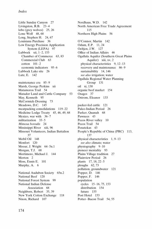
Little Sunday Canyon 27Livingston, R.B. 23±4lobo (grey wolves) 25, 26Lone Wolf 48, 68Long, Stephen H. 24, 67Louisiana Purchase 36Low Energy Precision Application
System (LEPA) 97Lubbock xii, 1±2, 153
Chamber of Commerce 63, 83Commercial Club 63cotton 101±2economic indicators 95±6
Lubbock Lake site 26Lutz, E. 142
maintenance era 85±9Marsh, George Perkins xiiMatamoros Trail 54Matador Land and Cattle Company 53May, Kenneth 95McCormick-Dressing 73Meadows, D.C. 145meatpacking consolidations 119±22Medicine Lodge Treaty 45, 46, 49, 68Mexico, war with 36±7militarization 33±5Mimosa borealis 24Mississippi River xiii, 96Missouri Volunteers, Indian Battalion
37Mobil Oil 148Monfort 120Mooar, J. Wright 64±5n.1Morgan, T.J. 68Mortimore, Michael J. 144Morton 2Moss, Ennis E. 101Murphy, A. 6
National Audubon Society 65n.2National Beef 120National Forest System 99National Indian Defense
Association 68Neighbors, Robert 35, 39New York Cotton Exchange 118Nixon, Richard 107
Nordhaus, W.D. 142North American Free Trade Agreement
115Northern High Plains 56
O'Connor, Martin 142Odum, E.P. 11, 24Oeltjen, J.W. 127Of®ce of Indian Affairs 46Ogallala Aquifer (Southern Great Plains
Aquifer) xiii, xv, 2physical characteristics 9, 12±13recovery and maintenance 86±9sustainability 14, 146see also irrigation; water
Ogallala Regional Water PlanningGroup 131
oil xi, 130organic beef market 154Osages 37Ostrom, Eleanor 133
packer-fed cattle 121Paleo-Indian Period 26Parker, Quanah 68Pawnees 43Pecos River valley 10Pecos Trail 54Penatekas 43People's Republic of China (PRC) 113,
137physical characteristics 1, 9±13
see also climate; waterphysiography 9±10pioneer mentality 93Plains Village tradition 27Plainview Period 26plants 17, 18, 22±5ploughs 62, 73pollution, groundwater 121Popper, D. 146Popper, F. 146population
cycles 15±16, 75, 153distribution 154future 155
Post Hotel 153Potter±Bacon Trail 54, 55
Index
174
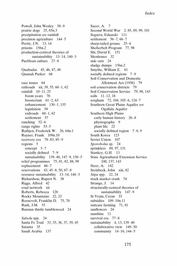
Powell, John Wesley 58±9prairie dogs 25, 65n.3precipitation see rainfallprecision agriculture 144±5Pretty, J.N. 13, 14prisons 156n.2production-centred theories of
sustainability 13±14, 140±3Puebloan culture 27±8
Quahadas 45, 46, 47, 48Quanah Parker 68
race issues 64railroads xii, 39, 55, 60±1, 62rainfall 10±11, 25
boom years 70boosterism 61±2, 63enhancement 130±1, 155legislation 58railroads 60±1, 62settlement 57
ranching 52±6range rights 53±5Rathjen, Frederick W. 26, 64n.1Rayner, Frank 109n.10recovery era 78±83, 85±9regions 5
concept 5±7socially de®ned 7±9sustainability 139±40, 147±9, 150±5
relief programmes 75, 81, 82, 88, 99replacement 66±7reservations 43, 45±8, 50, 67±8resource sustainability 13±14, 140±3Richardson, Rupert N. 38Riggs, Alfred 42road network xiiRoberts, Rebecca 128Rocky Mountains 22, 23Roosevelt, Franklin D. 75, 78Rusk, J.M. 55Russian thistle tumbleweed 24
Salsola spp. 24Santa Fe Trail 33, 35, 36, 37, 39, 45Satanta 35Saudi Arabia 137
Sayer, A. 7Second World War 2, 85, 89, 99, 101Segarra, Eduardo 111settlement 56±7, 66±7sharp-tailed grouse 25±6Shelterbelt Program 77, 98Shi, David E. 151Shoshones 32side oats 24sludge dumps 156n.2Smythe, William E. 61socially de®ned regions 7±9Soil Conservation and Domestic
Allotment Act (1936) 79soil conservation districts 79Soil Conservation Service 79, 98, 143soils 11±12, 18sorghum 72, 104, 105±6, 124±7Southern Great Plains Aquifer see
Ogallala AquiferSouthern High Plains
early human history 26±8physiography 9plant life 22socially de®ned region 7±8, 9
South Korea 123Soviet Union 107Sporobolus sp. 24sprinklers 89, 97, 131Stankey, G.H. 13State Agricultural Extension Service
100, 137, 143Steer, A. 142Steinbeck, John xiii, 82Stipa spp. 22, 24stock market crash 74Strange, J. 14structurally-centred theories of
sustainability 147±9St Vrain, Ceran 33subsidies 109±10n.11suitcase farming 71, 81sun¯owers 24sunshine 11survival era 77±8sustainability 4, 13, 139±40
collaborative view 149±50community 14±16, 144±5
Index
175

sustainability (cont.)ecosystem 17±18, 145±7region 139±40, 147±9, 150±5resource 13±14, 140±3
sweet bluestem 24Swift Independent 120
Tabananaka 68Takaki, Ronald 42Tatum, Lawrie 46Taylor, Paul 82Taylor Grazing Act (1934) 77±8temperatures 11, 25Ten Bears 45Texas Agricultural Experiment Station
131, 144Texas Agricultural Extension Service
100, 137, 143Texas Board of Water Engineers 92Texas cultural sink x±xiTexas fever 54±5Texas Longhorns 54±5Texas Panhandle Pueblo site 27Texas Rangers 38Texas Revolution 36Texas Water Plan 96, 155thread leaf sage 24three-awn grama 18Timber Culture Act (1873) 58tourism 153Trachypogon spp. 22tractors 2, 70±1, 73trade 30±2, 33±5
see also cattle; cottonTripascum spp. 22tumbleweed 24
Ufkes, Frances M. 134n.3Upper Republican culture 27Urban, L.V. 89US Department of Agriculture (USDA)
79, 102, 121, 123, 134n.4Agricultural Research Service 131
US Fish and Wildlife Service 130US Strategic Helium Reserves 2Utes 29, 32, 37
vertical integration 120
Wallace, Henry A. 78water 3±4, 12±13
current use and management inConservation District 129±34
future 154±5groundwater depletion 124±8preservation 132±4recovery and maintenance era 85±6sustainability 14see also irrigation; Ogallala Aquifer;
rainfallwater management plans 131Webb, Walter Prescott 54, 86, 87well-spacing 132Western Trail 54wheat 24, 71, 100, 103±6, 124±7White, R. 58, 84n.4White, Stephen E. 128±9Widtsoe, J.A. 62Wilber, Charles Dana 87wind 11windmills 86
generators 156n.2Winter Garden Bill 90wolves, grey 25, 26Woodland tradition 27Works Progress Administration 79, 82World Bank 122World Trade Organization 134n.4World War I 71World War II 2, 85, 89, 99, 101Worster, Donald 7, 8, 48, 49, 73, 79Wright, T.L. 109n.3Wright's three-awn grama 18
XIT Ranch 52, 53
Index
176