THE LANGAT RIVER BASIN - UM Repositoryrepository.um.edu.my/1223/5/Chapter 3 Revised.pdf · THE...
28
40 Chapter 3 THE LANGAT RIVER BASIN 3.1 INTRODUCTION This chapter describes the physical environment of the area under study. The location of Peninsular Malaysia and the Langat River are described in Section 3.1 and the general characteristics of the Langat drainage system are explained in Section 3.2. Catchment characteristics based on topographic map analysis are discussed in Section 3.3, while Sections 3.4, 3.5 and 3.6 emphasise the topography, geology, and soil of the catchment area. River regulation (impoundment) is covered in Section 3.7, followed by a more contextual climatic analysis (Section 3.8). Local authorities within the Langat River Basin is discussed in Section 3.9. Existing land use is discussed in Section 3.10. Section 3.11 concludes this chapter. Langat Basin is an important water catchment area providing raw water supply and other amenities to approximately 1.2 million people within the basin. Important conurbations served include towns such as Cheras, Kajang, Bangi, Government Centre of Putrajaya and others. There are two reservoirs (Semenyih and Hulu Langat) and 8 water treatment plants (4 of which operates 24 hours), which provide clean water to the users after undergoing treatment. Use of Langat River is not only limited to water supply but also for other purposes such as recreation, fishing, effluent discharge, irrigation and even sand mining, to name a few. These multi faceted usage of the river results in conflicting interest from
-
Upload
duongkhanh -
Category
Documents
-
view
219 -
download
0
Transcript of THE LANGAT RIVER BASIN - UM Repositoryrepository.um.edu.my/1223/5/Chapter 3 Revised.pdf · THE...
40
Chapter 3
THE LANGAT RIVER BASIN
3.1 INTRODUCTION
This chapter describes the physical environment of the area under study. The location
of Peninsular Malaysia and the Langat River are described in Section 3.1 and the
general characteristics of the Langat drainage system are explained in Section 3.2.
Catchment characteristics based on topographic map analysis are discussed in Section
3.3, while Sections 3.4, 3.5 and 3.6 emphasise the topography, geology, and soil of
the catchment area. River regulation (impoundment) is covered in Section 3.7,
followed by a more contextual climatic analysis (Section 3.8). Local authorities
within the Langat River Basin is discussed in Section 3.9. Existing land use is
discussed in Section 3.10. Section 3.11 concludes this chapter.
Langat Basin is an important water catchment area providing raw water supply and
other amenities to approximately 1.2 million people within the basin. Important
conurbations served include towns such as Cheras, Kajang, Bangi, Government
Centre of Putrajaya and others. There are two reservoirs (Semenyih and Hulu Langat)
and 8 water treatment plants (4 of which operates 24 hours), which provide clean
water to the users after undergoing treatment.
Use of Langat River is not only limited to water supply but also for other purposes
such as recreation, fishing, effluent discharge, irrigation and even sand mining, to
name a few. These multi faceted usage of the river results in conflicting interest from

41
the perspective of the various stakeholders. Therefore, there is a need for proper
resource optimization and resolution of conflict.
Lately, the Langat Basin water resource is under stress due to poor water quality.
Areas starting from Sg. Cheras downstream to Permatang Pasir near the sea, are of
Classes III to V. Point and non-point sources of pollution from domestic and
industrial sources of pollution be either it soluble organic or solid, found their way
into the rivers resulting in heavy pollution and poor water quality.
3.2 STUDY AREA
3.2.1 The Peninsular Malaysia
Peninsular Malaysia is located at the southern end of the Malay Peninsula which is at
the southern extremity of Southeast Asia. It extends from 1o 15’N to 6
o 45’N latitudes
and 99o 40’E to 104
o 35’E longitudes. To the east it is bounded by the South China
Sea and to the west by Straits of Malacca. It shares a common boundary with
Thailand in the north and is separated from the island of Singapore in the south, by
the narrow Straits of Johor. Peninsular Malaysia covers an area of 127,560 km2. Its
maximum length is 736 km, while its maximum width is 322 km. Its coastline extends
some 1930 km. Altogether, Malaysia has more than 150 river systems spread over a
total land mass of 329,760 km2.

42
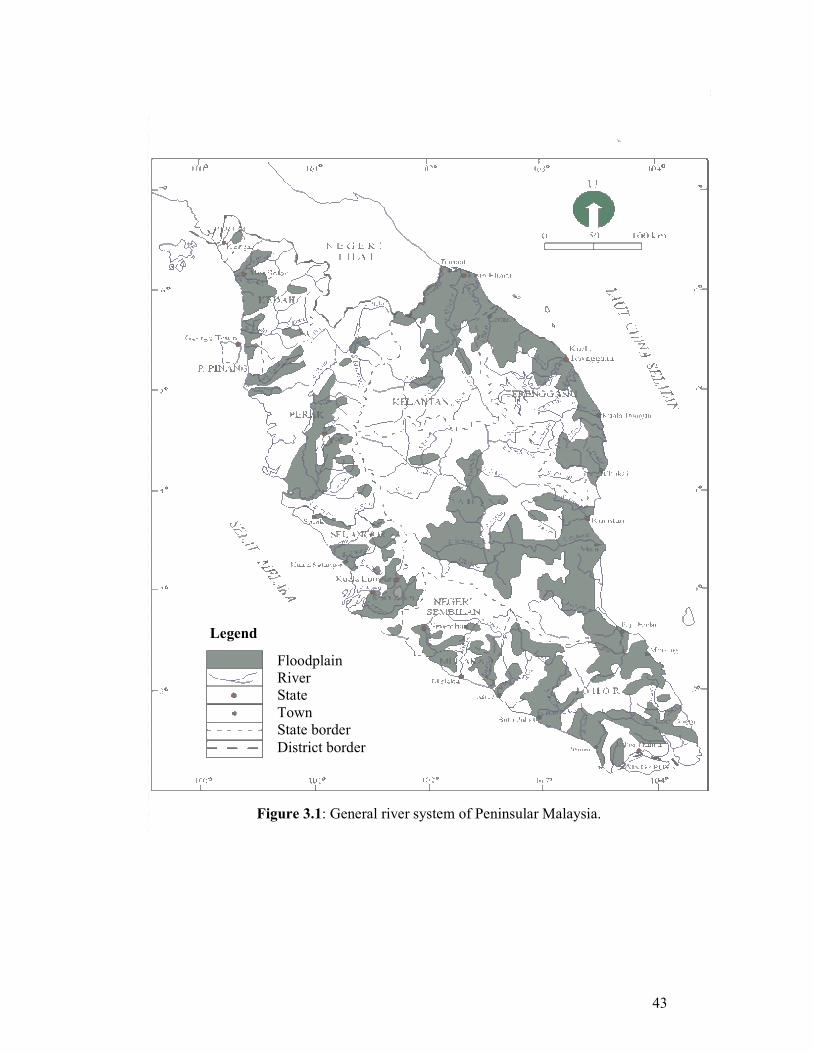
The constant and heavy rainfall of the Peninsular Malaysia gives rise to a dense
network of rivers and streams (Figure 3.1). The largest river in Peninsular Malaysia,
the Pahang River has a length of about 434 km and a catchment area of approximately
29000 km2. The catchment areas of the other three large rivers are 15,151 km
2 (Perak
River), 12,612 km2 (Kelantan River) and 4273 km
2 (Muda River).
Streams flow in the upper and middle reaches of Peninsular Malaysian rivers and is
usually swift and strong, but slow and sluggish in the lower course. The main
mountain ranges which run more or less parallel to the west coast form a continuous
watershed from the northern borders of Peninsular Malaysia to Malacca. The rivers
west of this watershed have relatively short courses. Their gradients in the upper
courses are very steep: some rivers drop about 1219 m in less than 24 km before they
emerge onto the coastal plains (Oii, 1963). The very rapid decrease in the flow rates
of the rivers at the foot of the mountains reduces the carrying capacity of the rivers.
This causes them to drop their load of coarser-grained material and are carried by the
slow meandering rivers and deposited at the river mouths and along the coastal
stretches. There is therefore a roughly parallel zoning of marine and riverine
sediments on the west coast.
While the headwaters of most river exhibit steep gradients, waterfalls and rapids, the
lower courses, in contrast, characteristically show signs of maturity such as channel
braided, meanders, ox-bows and levees. The river profiles thus present a typically
flattened appearance, and have been influenced by quaternary changes in sea level
and progressive sedimentation by the over-loading of rivers.
43
Figure 3.1: General river system of Peninsular Malaysia.
Floodplain
River
State
Town
State border
District border
Legend

44
3.2.2 Langat River Basin
The Langat River has a total catchment area of approximately 1815 km2. It lies within
latitudes 2o 40’M 152” N to 3
o 16’M 15” and longitudes 101
o 19’M 20” E to 102
o
1’M 10” E. The catchment is illustrated in Figure 3.2. The main river course length is
about 141 km mostly situated around 40 km east of Kuala Lumpur. The Langat River
has a several tributaries with the principal ones being the Semenyih River, the Lui
River and the Beranang River. There are two reservoirs, the Langat Reservoir and the
Semenyih Reservoir respectively. The Langat Reservoir, built in 1981 has a
catchment area of 54 km2 while the Semenyih Reservoir, built in 1982 with the
purpose to supply domestic and industrial water has a catchment area of 41 km2. For
the Langat Reservoir, it is also used to generate power supply at moderate capacity for
the population within the Langat Valley.
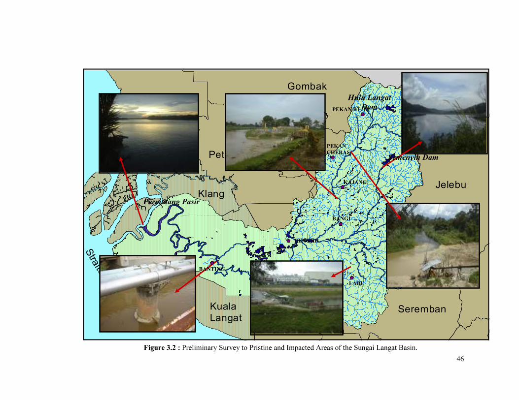
The study areas include selected impacted and non-impacted stretches of the Sungai
Langat Basin (Figure 3.2). Areas surveyed and identified begin from the upstream;
starting with the Semenyih and Hulu Langat Dams down to the lowest area at the
estuary near Permatang Pasir with a total distance of 78 km. Since the total catchment
area of Sungai Langat Basin is substantial (1987.7 km2), it is realistic only to consider
the critically impacted areas that give rise to the lowering of water quality within the
river basin. The water quality at the Semenyih Dam and upstream of the Semenyih
Dam is of Class I. In comparison, the water quality is seen to deteriorate further
downstream from the Semenyih Dam; varying from Class III to V water quality due
to various land use activities.
45
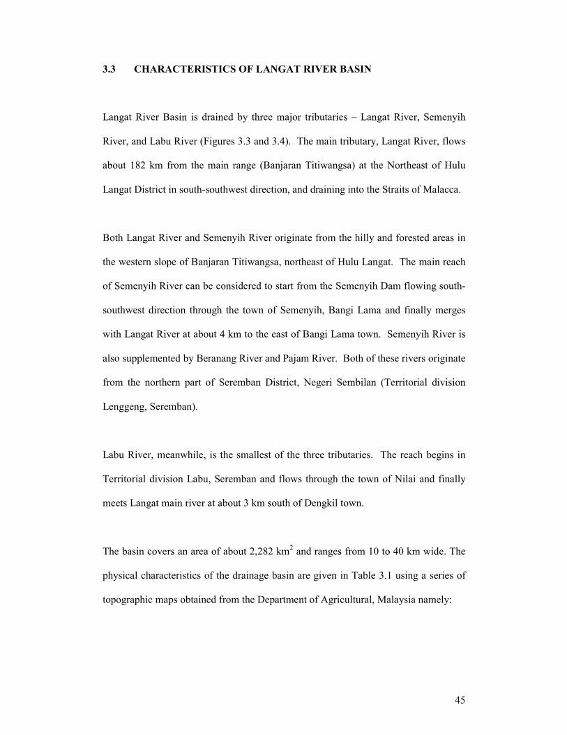
3.3 CHARACTERISTICS OF LANGAT RIVER BASIN
Langat River Basin is drained by three major tributaries – Langat River, Semenyih
River, and Labu River (Figures 3.3 and 3.4). The main tributary, Langat River, flows
about 182 km from the main range (Banjaran Titiwangsa) at the Northeast of Hulu
Langat District in south-southwest direction, and draining into the Straits of Malacca.
Both Langat River and Semenyih River originate from the hilly and forested areas in
the western slope of Banjaran Titiwangsa, northeast of Hulu Langat. The main reach
of Semenyih River can be considered to start from the Semenyih Dam flowing south-
southwest direction through the town of Semenyih, Bangi Lama and finally merges
with Langat River at about 4 km to the east of Bangi Lama town. Semenyih River is
also supplemented by Beranang River and Pajam River. Both of these rivers originate
from the northern part of Seremban District, Negeri Sembilan (Territorial division
Lenggeng, Seremban).
Labu River, meanwhile, is the smallest of the three tributaries. The reach begins in
Territorial division Labu, Seremban and flows through the town of Nilai and finally
meets Langat main river at about 3 km south of Dengkil town.
The basin covers an area of about 2,282 km2 and ranges from 10 to 40 km wide. The
physical characteristics of the drainage basin are given in Table 3.1 using a series of
topographic maps obtained from the Department of Agricultural, Malaysia namely:
46
Kuala Lumpur
Petaling
Kuala Langat
Sepang
Seremban
JelebuKlang
Kuala Selangor
Gombak Pahang
Straits o
f Malacca
Figure 3.2 : Preliminary Survey to Pristine and Impacted Areas of the Sungai Langat Basin.
Permatang Pasir
Semenyih Dam
Hulu Langat
Dam
BANTING
DENGKIL
KAJANG
BANGI
PEKAN
CHERAS
PEKAN BT. 18
LABU
47
iii) Topographic map series L7039, sheet 3857(1993), scale 1:50,000
iv) Topographic map series L7030, sheet 3856(1996), scale 1:50,000
Drainage density (D) is the ratio of the total channel lengths accumulated for all orders
within the catchment area (Horton, 1945). Based on Strahler’s (1957) texture
classification, the drainage density of the Langat Basin can be said to be that of low
density (Table 3.1).
The bifurcation ratio was defined by Horton (1945) as the ratio of the number of streams
of one order to the number of streams of the next highest order (n + 1). In the Langat
River catchment, the average value of the bifurcation ratio of 4.93. Taking Peninsular
Malaysian examples from Sabry (1997) at Tekala River (5.1), Koh (1978) at Lui River
(3.75) and Mykura (1989) at Klang River (5.9), the mean bifurcation ratio at most of the
catchment areas in the Peninsular tends to approximate 5.

48
Figure 3.3: Langat Drainage Basin.

49
Table 3.1: Physical characteristics of Langat River catchment.
Characteristics
Symbol
Value
Area (km2) A 1815
Total stream length (km) Ct 2530.46
Catchment length (km) L 828.4
Catchment width (km) C 894.3
Length of the main channel (km) LMC 142.38
Catchment relief m Hb 2103
Relief-area ratio 1.16
Stream order U 5
Mean length stream order 1 km 88.98
Mean length stream order 2 km 98.53
Mean length stream order 3 km 148.3
Mean length stream order 4 km 196.36
Total number of stream order 1 182
Total number of stream order 2 159
Total number of stream order 3 64
Total number of stream order 4 9
Total number of stream order 5 1
Mean of bifurcation ratio: Br
Order 2
Order 3
Order 4
Order 5
Average Br
1.14
2.48
7.1
9
4.93
Mean of stream length ratio RL 8.21
Drainage density km/km2 Ct/A D 1.39
Relief ratio Hb/L 2.54
Catchment width ratio A/L 2.191
Slopes 28.31o
(Source: Various topographic maps, geology and soils maps, Malaysia)

50
3.4 TOPOGRAPHY
3.4.1 Peninsular Malaysia
Topographically, Peninsular Malaysia is characterized by a central mountain range
(the Banjaran Titiwangsa) surrounded by coastal plains with more than half of the
total area being higher than 150 m above sea level. Almost all rivers originate from
Banjaran Titiwangsa range flows either into the Straits of Malacca or the South China
Sea.
3.4.2 The Langat River Basin
Langat River basin can be divided into 3 distinct zones (Saharudin Idrus, 2004). The
first can be referred to as the mountainous zone of the northeast corner of Hulu
Langat district. The average height of the highland ranges is about 960 meter above
mean sea level. Most of the mountainous region is below 500 m from the mean sea
level.
The second zone is the hilly area characterised by gentle slopes spreading widely
from north to the east in the middle part of Langat basin. The area is generally below
100 m and the lower part of the hills extends to Putrajaya, Cyberjaya, and Dengkil in
Sepang. Langat River flows gently in the hilly area. The river sediment changes
composition gradually from boulder/gravel in the mountainous zone, to sand, and then
silt in the hilly areas.
51
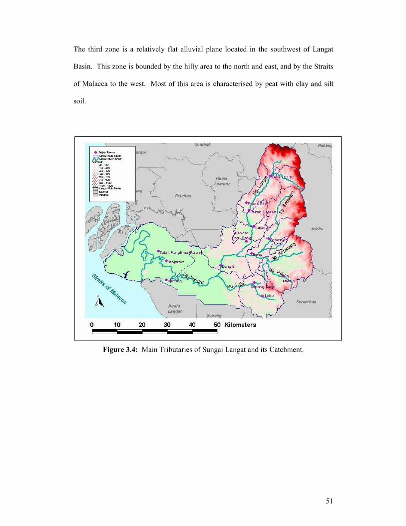
The third zone is a relatively flat alluvial plane located in the southwest of Langat
Basin. This zone is bounded by the hilly area to the north and east, and by the Straits
of Malacca to the west. Most of this area is characterised by peat with clay and silt
soil.
Figure 3.4: Main Tributaries of Sungai Langat and its Catchment.

52
3.5 GEOLOGY
3.5.1 Regional geology of Peninsular Malaysia
Peninsular Malaysia is part of the orogenic belt extending from north-west China,
through east Myanmar and west of Thailand and Indonesia in the south. It consists of
various types of rocks that show a variety of palae environmental origins, with ages
ranging from Upper Cambrian to Quatenary. The Upper Cambrian strata are
characterized by orthoquartzitic sedimentary rocks, whereas the Silurian rocks are
predominantly of an argillaceous and carbonate rocks. These argillaceous rocks
include shale and calcareous shale. Volcanic activity produced mainly acidic tuff
during this period. During the Devonian, a thick succession of limestone was
deposited. These limestone forms hills in a few states, with steep slopes or vertical
cliffs protruding from the flat alluvial areas.
Peninsular Malaysia is also a Palaeozoic-Mesozoic structure which is part of the
Pacific orogeny which has experienced complex tectonic activity, orogenic and post-
orogenic. During the Mesozoic era, the layering of the sedimentary rocks was
transformed into a series of gigantic folds. At the same time, a number of granitic
instrusions occurred throughout the peninsular. Subsequently, Peninsular Malaysia
has been transformed into part of the stable Sunda shield. A number of sedimentary
valleys of Tertiary age are found and are rich in coal deposits. Tjia (1978) divided
Peninsular Malaysia into three mineral belts, known as the West Tin Belt, the East Tin
Belt and Central Belt.

53
3.5.2 Geology of the Langat River Basin
Bedrock in the mountain area near the source of the river is granite that forms the
mountain bone of the peninsula and it extends around hilly areas near Kg. Cheras.
Layers of the hilly areas are called Kenny Hill Formation and Kajang Formation,
consisting of metamorphosed sandstone, shale, mudstone, and schist. The upper part
of the bedrock including those of granite is weathered. Some parts are heavily
weathered with depths of several meters (JICA, 2001).
In the low flatlands, thick quaternary layers are deposited on the bedrock. The
quaternary layer, from the top to the bottom, consists of 0.5 to 5.5m deep Beruas
Formation with peat layer at the top, clayey Gula Formation and Kempadang
Formation starting in the hilly areas and having a 40 to 50 m depth near the seacoast.
Lying underneath is the Simpang Formation of sand and gravel with thickness of
several meters in the hilly area and about 50 m to more than 100 m in the low
flatlands (JICA, 2001).
3.6 SOIL
3.6.1 Regional soil of Peninsular Malaysia
Two broad groups of soils are evident in Peninsular Malaysia. The first consists of
soils developed on igneous, metamorphic and sedimentary rocks. These are the
sedentary soils of interior hills and mountainous. The second group is formed on
54
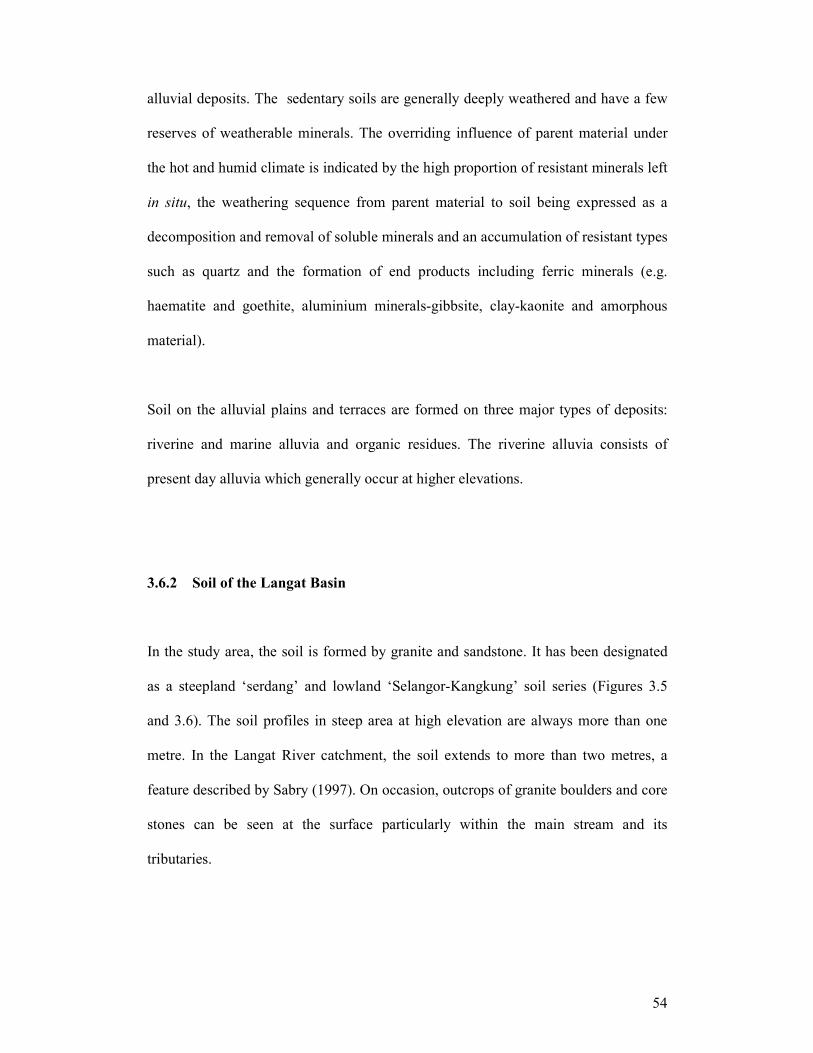
alluvial deposits. The sedentary soils are generally deeply weathered and have a few
reserves of weatherable minerals. The overriding influence of parent material under
the hot and humid climate is indicated by the high proportion of resistant minerals left
in situ, the weathering sequence from parent material to soil being expressed as a
decomposition and removal of soluble minerals and an accumulation of resistant types
such as quartz and the formation of end products including ferric minerals (e.g.
haematite and goethite, aluminium minerals-gibbsite, clay-kaonite and amorphous
material).
Soil on the alluvial plains and terraces are formed on three major types of deposits:
riverine and marine alluvia and organic residues. The riverine alluvia consists of
present day alluvia which generally occur at higher elevations.
3.6.2 Soil of the Langat Basin
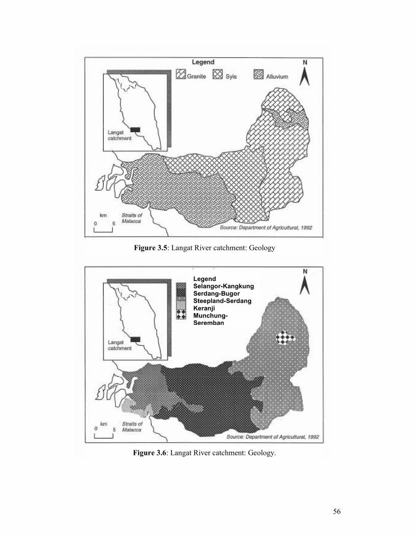
In the study area, the soil is formed by granite and sandstone. It has been designated
as a steepland ‘serdang’ and lowland ‘Selangor-Kangkung’ soil series (Figures 3.5
and 3.6). The soil profiles in steep area at high elevation are always more than one
metre. In the Langat River catchment, the soil extends to more than two metres, a
feature described by Sabry (1997). On occasion, outcrops of granite boulders and core
stones can be seen at the surface particularly within the main stream and its
tributaries.
55
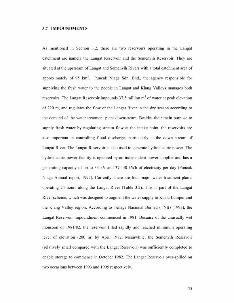
3.7 IMPOUNDMENTS
As mentioned in Section 3.2, there are two reservoirs operating in the Langat
catchment are namely the Langat Reservoir and the Semenyih Reservoir. They are
situated at the upstream of Langat and Semenyih Rivers with a total catchment area of
approximately of 95 km2. Puncak Niaga Sdn. Bhd., the agency responsible for
supplying the fresh water to the people in Langat and Klang Valleys manages both
reservoirs. The Langat Reservoir impounds 37.5 million m3 of water at peak elevation
of 220 m, and regulates the flow of the Langat River in the dry season according to
the demand of the water treatment plant downstream. Besides their main purpose to
supply fresh water by regulating stream flow at the intake point, the reservoirs are
also important in controlling flood discharges particularly at the down stream of
Langat River. The Langat Reservoir is also used to generate hydroelectric power. The
hydroelectric power facility is operated by an independent power supplier and has a
generating capacity of up to 33 kV and 37,440 kWh of electricity per day (Puncak
Niaga Annual report, 1997). Currently, there are four major water treatment plants
operating 24 hours along the Langat River (Table 3.2). This is part of the Langat
River scheme, which was designed to augment the water supply to Kuala Lumpur and
the Klang Valley region. According to Tenaga Nasional Berhad (TNB) (1993), the
Langat Reservoir impoundment commenced in 1981. Because of the unusually wet
monsoon of 1981/82, the reservoir filled rapidly and reached minimum operating
level of elevation (200 m) by April 1982. Meanwhile, the Semenyih Reservoir
(relatively small compared with the Langat Reservoir) was sufficiently completed to
enable storage to commence in October 1982. The Langat Reservoir over-spilled on
two occasions between 1993 and 1995 respectively.
56
Figure 3.5: Langat River catchment: Geology
Figure 3.6: Langat River catchment: Geology.
Legend Selangor-Kangkung Serdang-Bugor Steepland-Serdang Keranji Munchung-Seremban

57
Table 3.2: Location of intake points along the Langat River.
Intake Point
Latitude-Longitude
Langat River at Bukit Tampoi 2o 50” 48’ – 101
o 40” 48
’
Langat River at Cheras Batu 11 3o 01” 36’ – 101
o 46” 36’
Langat River at Hulu Langat 3o 04” 42’ – 101
o 47” 18’
Semenyih River 2o 59” 00’ – 101
o 52” 00’
3.8 CLIMATE
3.8.1 Regional climate of Peninsular Malaysia
Malaysia falls within the humid tropics (Chang, 1993) and has a climate which is
equatorial and greatly influenced by both North East (NE) and South West (SW)
monsoons. The monsoons typically bring heavy rainfall while convectional rain is
common during inter-monsoonal periods. Much of the rainfalls are received mainly
during SW and NE monsoons. The NE monsoon brings rains to the east coast of
Peninsular Malaysia during November to February while the SW monsoon prevails
for the period of June to early October at the west coast of Peninsular Malaysia.
Neverthless, localized thunderstorms occur all the year round and at times can be very
intense particularly during the intermonsoon months of March-May. The highest
rainfall exceeds 5000 mm and the lowest is about 1750 mm. The average annual
rainfall is 2820 mm in Peninsular Malaysia, but there is considerable temporal and
spatial variation.
Dale (1959) divided the rainfall pattern in Peninsular Malaysia into four periods based
on the Southeast Asian Monsoon.
58
1. The NE monsoon, prevailing from November or early December until March.
2. The transitional period or inter-monsoon, occurring in April until May (five to
seven weeks).
3. The SW monsoon, predominating in June until September or early October.
4. The transitional period or inter-monsoon, wide-spreading in October and
November.
3.8.2 Climate of the Langat River Basin
The climate of the study area in Langat River is similar to the climate of Peninsular
Malaysia which is equatorial-monsoon. This climate is characterized by high average
and uniform annual temperatures, high rainfall and high humidity. This climate has a
dominant impact on the hydrology and geomorphology of the study area. Generally
the study area experiences two types of season: the wet season in April to end of
November, and a relatively drier period from January to March. The weather is very
much influenced by the SW monsoon which blows across the Straits of Malacca.
Flooding is common in the study area during this period particularly when it coincides
with localized rainfall.
3.8.2.1 Precipitation
The rainfall for the west is differentiated on the basis of a double maximum occurring
during the two inter-monsoon seasons in April and October to September, but the

59
double minimum is prevalent during the two monsoons seasons. The highest intensity
storms normally occur during the months of October, November, December and
April. The driest month in the west is July, and February is the second driest month.
3.8.2.2 Temperature
The mean annual temperature of the lowland in Peninsular Malaysia varies within +
1.7oC to 26.70
oC (the lowlands are classified as the area below 152 m). The eastern of
the Peninsular Malaysia is cooler than the western side (difference by 1.7o C) and the
difference in temperature between the two sides of Peninsular Malaysia decreases
northward (Dale, 1963).
Although the study area reaches are located in three different land characteristics (the
upland area, an intermediate or transitional area between upland and lowland area and
the lowland area), temperatures remains relatively uniform throughout the year. At the
University Kebangsaan Malaysia (UKM), Bangi station for instance, the mean annual
temperature over 16 years is around 24.25oC (Table 3.3).

60
Figure 3.7: Rainfall regions in Peninsular Malaysia.
Table 3.3: Climate data of UKM Bangi Station from 1985 – 2000.
Climate data Annual Unit Average
Mean daily sunshine 5.71 Hour 16 years
Mean daily temperature 24.3 oC
16 years
Mean daily evaporation 3.48 Mm 16 years
Mean daily relative humidity 93.9 % 4 years
Mean surface wind speed 1.59 m s-1
16 years
3.9 LOCAL AUTHORITIES WITHIN THE LANGAT RIVER BASIN
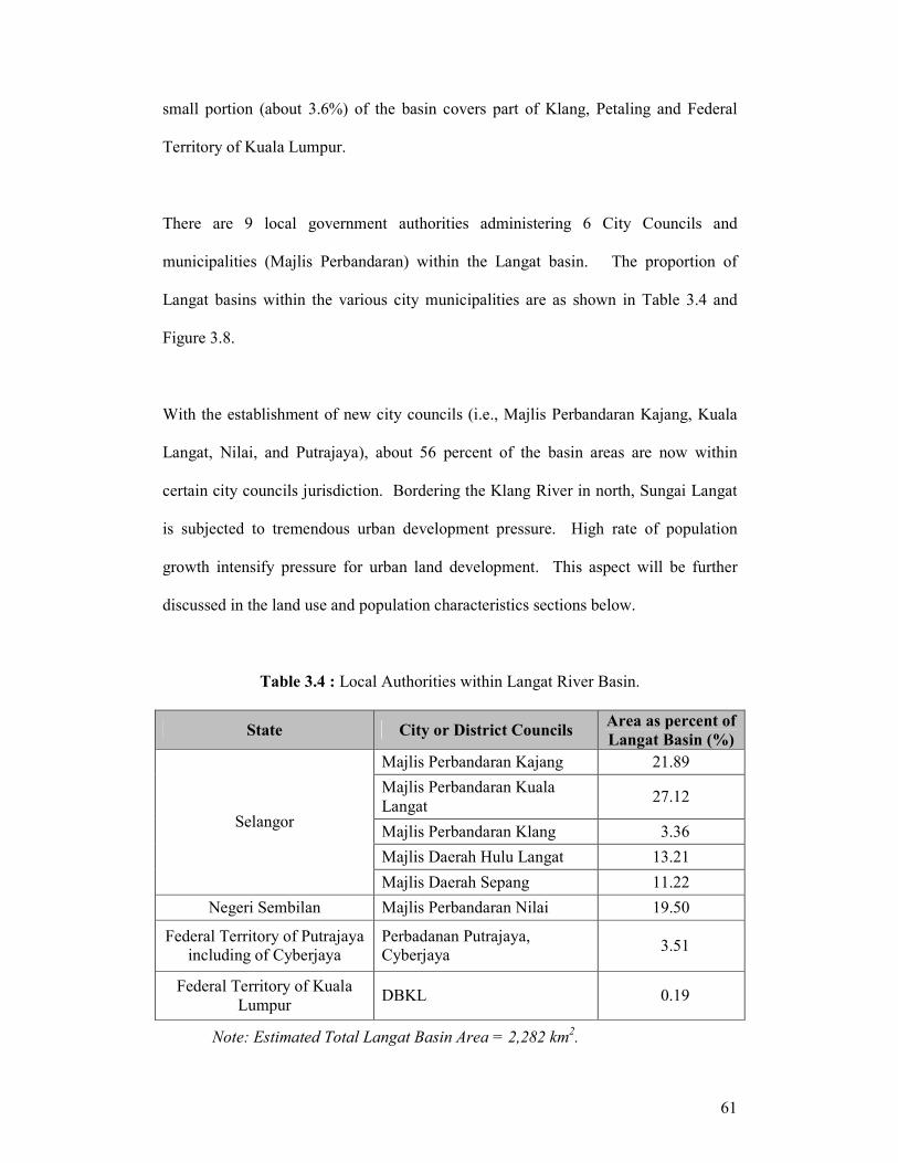
Sungai Langat Basin extends to two states. A large proportion of the Langat basin
(about 76 %) is located within the districts of Hulu Langat, Sepang, and Kuala
Langat, Selangor. About 20% of the basin area is in Seremban, Negeri Sembilan. A
Source: Dale (1959)
61
small portion (about 3.6%) of the basin covers part of Klang, Petaling and Federal
Territory of Kuala Lumpur.
There are 9 local government authorities administering 6 City Councils and
municipalities (Majlis Perbandaran) within the Langat basin. The proportion of
Langat basins within the various city municipalities are as shown in Table 3.4 and
Figure 3.8.
With the establishment of new city councils (i.e., Majlis Perbandaran Kajang, Kuala
Langat, Nilai, and Putrajaya), about 56 percent of the basin areas are now within
certain city councils jurisdiction. Bordering the Klang River in north, Sungai Langat
is subjected to tremendous urban development pressure. High rate of population
growth intensify pressure for urban land development. This aspect will be further
discussed in the land use and population characteristics sections below.
Table 3.4 : Local Authorities within Langat River Basin.
State City or District Councils Area as percent of
Langat Basin (%)
Majlis Perbandaran Kajang 21.89
Majlis Perbandaran Kuala
Langat 27.12
Majlis Perbandaran Klang 3.36
Majlis Daerah Hulu Langat 13.21
Selangor
Majlis Daerah Sepang 11.22
Negeri Sembilan Majlis Perbandaran Nilai 19.50
Federal Territory of Putrajaya
including of Cyberjaya
Perbadanan Putrajaya,
Cyberjaya 3.51
Federal Territory of Kuala
Lumpur DBKL 0.19
Note: Estimated Total Langat Basin Area = 2,282 km2.

62
Figure 3.8: Local Authorities within Sungai Langat Basin.
3.10 LAND USE IN LANGAT RIVER BASIN
3.10.1 Forest Status
The forestry sector in Selangor is one of the main sources of income to the state
government. In 1997 for example, a total of RM25 million was generated by this
sector. The forested areas are located in the eastern and northern part of Hulu Langat
and managed by the The Forestry Department under the ‘Forestry Act, 1985’ and ‘Act
127 (Surrounding Environmental Quality Act) PU (A) 326/1987’. Areas in the
catchment including Langat and Semenyih were gazetted as ‘Reserved Forest’;

63
however logging activities are still carried out under the ‘Selective Logging Scheme’.
These areas have proper limited logging licenses in order to reduce the environmental
hazard in the lowland area related to mud flows, siltation and flash floods. The Hulu
Langat Forest Reserve is one of nine reserves (representing about 26 per cent of the
total forest reserves) in Selangor. The Hulu Langat Forest Reserve is covered with hill
dipterocarps at altitudes ranging from 120 m to 1265 m above sea level. Prior to the
establishment of the Langat Dam, the Hulu Langat Forest Reserve had been logged
for timber production as early as 1944, particularly in the Congkak sub-catchment.
However, logging ceased in 1987.
Natural forest cover in this catchment is part of the Tropical Forest and is one of the
most complex ecosystems in the world. Generally, there are three major forest types
in the Langat Catchment: dipterocarp, peat swamp and mangrove forests. In the Hulu
Langat and Seremban Districts only lowland and hill dipterocarp forests are found.
Peat swamp forests are mostly found in Sepang and in parts of Kuala Langat Districts
whereas mangrove forests are found on the islands on the coast and along the coastal
margins of the mainland.
Over the years, diptrerocarp forests remained the main type of forest cover in the
basin, comprising 40-55 per cent of the total forest cover. The proportion of swamp
forests in the catchment declined rapidly (Table 3.5) and by 1991/1992 constituted
only 18.6 per cent of the total forest type. The proportion of mangrove forests
remained about the same from 1971 to 1982 but because of the rapid loss of peat
swamp forests, increased to 27 per cent by 1992.

64
The total area of diptrerocarp forest in the catchment declined by about 10.9 per cent
between 1971 to 1992. The increase reported in 1981/1982 might have been caused
by inaccuracies in the base map but there was essentially no difference in the area
under dipterocarp forests in the catchment between the 1970s and 1980s (Saiful,
2000). A similar aberration was also assumed to affect the estimates of the total area
under mangrove forests. As shown in Table 3.5, the forest was reduced in size by
almost 4.0 per cent in 1981/82 from 215.6 km2 in 1971/72, but in 1991/92 it increased
by a similar amount. Peat swamp forests declined considerably over the same period
when the majority of areas originally under such forests were converted to agriculture.
Table 3.5: Size of each type of forest of the Langat Catchment in 1971/72, 1981/82
and 1991/92.
Years Type of forest
1971/72 (km2) 1981/82 (km
2) 1991/92 (km
2)
Dipterocarp 492.7 (44.6) 501.0 (50.0) 438.9 (54.6)
Peat swamp forest 396.2 (35.9) 293.1 (29.3) 149.4 (18.6)
Mangrove forest 215.6 (19.5) 207.0 (20.0) 215.5 (26.8)
Total 1, 104.5 1, 001.1 803.8
3.10.2 Industry
In Selangor, particularly within the Langat River catchment achieved, over a period of
slightly more than two decades, tremendous growth occurred in the manufacturing
sector, and had become the most industrialised state in Peninsular Malaysia.
Presently, there are 30 industrial estates housing more than 330 factories located in
the Langat River catchment. These factories engage in 22 categories of industrial
production ranging from the manufacture of agricultural end-products to high-
technology products such as consumer electronics.
65
3.10.3 Mining
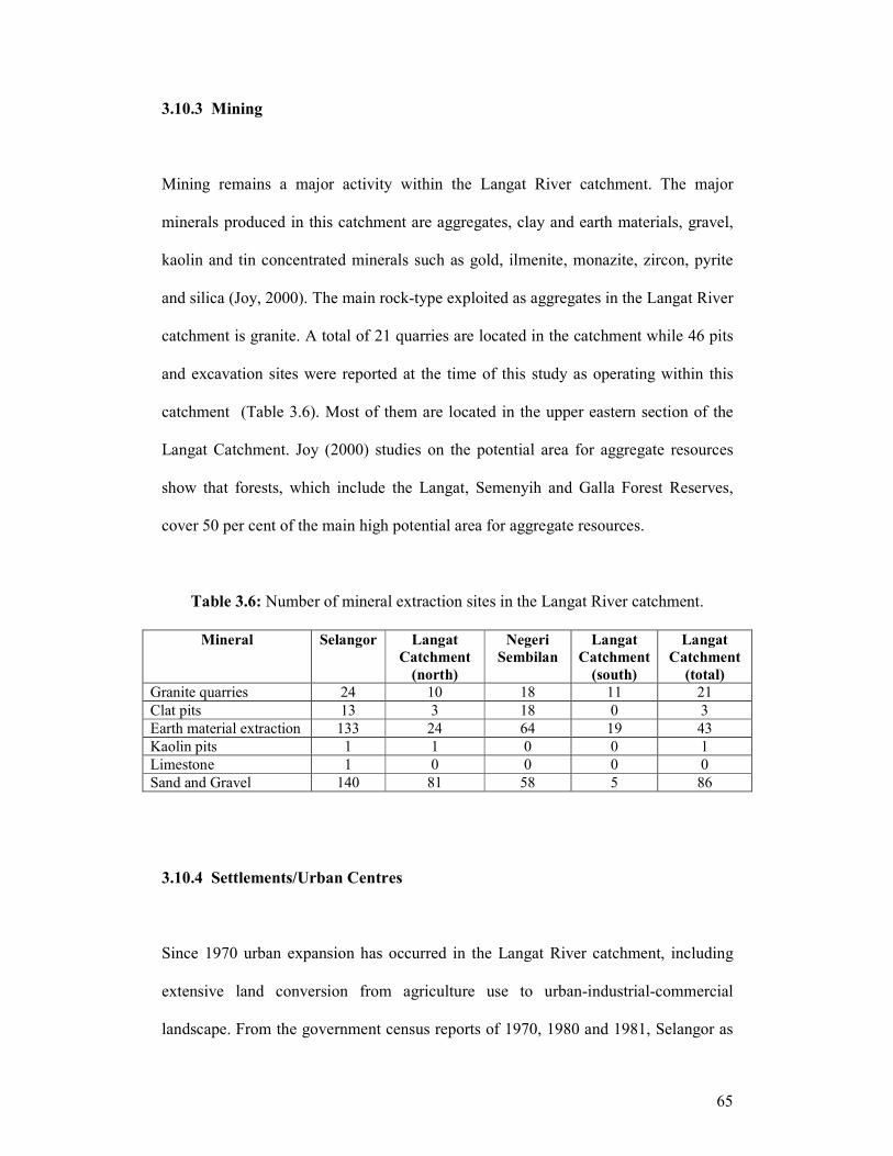
Mining remains a major activity within the Langat River catchment. The major
minerals produced in this catchment are aggregates, clay and earth materials, gravel,
kaolin and tin concentrated minerals such as gold, ilmenite, monazite, zircon, pyrite
and silica (Joy, 2000). The main rock-type exploited as aggregates in the Langat River
catchment is granite. A total of 21 quarries are located in the catchment while 46 pits
and excavation sites were reported at the time of this study as operating within this
catchment (Table 3.6). Most of them are located in the upper eastern section of the
Langat Catchment. Joy (2000) studies on the potential area for aggregate resources
show that forests, which include the Langat, Semenyih and Galla Forest Reserves,
cover 50 per cent of the main high potential area for aggregate resources.
Table 3.6: Number of mineral extraction sites in the Langat River catchment.
Mineral Selangor Langat
Catchment
(north)
Negeri
Sembilan
Langat
Catchment
(south)
Langat
Catchment
(total)
Granite quarries 24 10 18 11 21
Clat pits 13 3 18 0 3
Earth material extraction 133 24 64 19 43
Kaolin pits 1 1 0 0 1
Limestone 1 0 0 0 0
Sand and Gravel 140 81 58 5 86
3.10.4 Settlements/Urban Centres
Since 1970 urban expansion has occurred in the Langat River catchment, including
extensive land conversion from agriculture use to urban-industrial-commercial
landscape. From the government census reports of 1970, 1980 and 1981, Selangor as
66
one of the more populated states in Malaysia has recorded a rapid growth from a total
of less than one million in the 1970 Population Census, through 1.4 million in 1980 to
close to 2.3 million in 1991 Census. It has been estimated that the population in
1998/1999 was around 3.1 million people (Abdul Hadi and Samad, 2000).
Figure 3.9 shows the population in the Sg. Langat Basin for Kuala Langat, Sepang
and Hulu Langat, Selangor. Based on the latest population census ( 2000 ) the
population statistics by territorial division and districts show that there are a total of
1,176,173 persons in the entire Sg. Langat Basin, of which 1,165,267 persons occupy
the three ( 3 ) districts of Selangor. Among the three districts, Ulu Langat showed the
highest increment of population from 413,900 persons in year 1990 to 864,451
persons in year 2000, followed by Kuala Langat where the population increased from
130,000 persons in year 1990 to 192,167 persons in year 2000 and Sepang District
from 54,671 in year 1990 to 108,640 in year 2000 (Department of Statistics Malaysia,
1990; 2000). The significant increment was recorded in the population of these three
districts during the last 11 years, from 598,661 persons in year 1990 to 1,165,267
persons in year 2000, an increase of 94.66% or 8.6% per annum.

67
0
100000
200000
300000
400000
500000
600000
700000
800000
900000
1000000
Kuala Langat Sepang Ulu Langat
Population
1990
2000
Figure 3.9: Population densities of Langat River Basin, by district, in years 1990 and
2000.
3.11 CONCLUSION
This chapter explores in particular the physical environment of the Langat River
catchment. Salient aspects of physical catchment characteristics are discussed in
details. This provides a clear picture of Langat River Basin and the need for further
investigation and analysis which will be discussed in the next chapter (Chapter 4).