The Kolkata Municipal Corporation Kolkata Environmental ... KEIIP.pdf · The Kolkata Municipal...
24
The Kolkata Municipal Corporation Kolkata Environmental Improvement Investment Program Loan No.3053-IND INVITATION FOR EXPRESSION OF INTEREST Date : 11.12.2015 Kolkata Municipal Corporation represented by Project Director, KEIIP, 206, A.J.C.Bose Road, 2 nd Floor, Kolkata-700017, West Bengal, India invites Expression of Interest from eligible Consultants for Consulting Service for Web Enabled Integrated Infrastructure Information System Using Remote Sensing and GIS in Kolkata (Contract No.KEIIP/TR-1/KCS-4/2015-16). Estimated Budget : INR 56.83 Million / USD 0.90 Million, Estimated Expertise: 1463 person-months of national experts (87 key experts and 1376 non-key experts). Submission Date & Time of EOI : 11.01. 2016 at or before 2.30 P.M. (IST). Interested Consultants should visit ADB’s website for CSRN (http:/cms.adb.org) about specific requirements and submit Expression of Interest (EOI) following the instructions in the CSRN website. For further details, Consultants may also visit our website : www.keiip.in Kolkata Environmental Improvement Investment Program
Transcript of The Kolkata Municipal Corporation Kolkata Environmental ... KEIIP.pdf · The Kolkata Municipal...
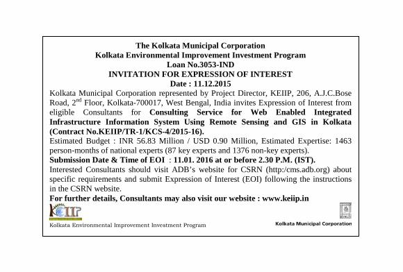
The Kolkata Municipal Corporation Kolkata Environmental Improvement Investment Program
Loan No.3053-IND INVITATION FOR EXPRESSION OF INTEREST
Date : 11.12.2015 Kolkata Municipal Corporation represented by Project Director, KEIIP, 206, A.J.C.Bose Road, 2nd Floor, Kolkata-700017, West Bengal, India invites Expression of Interest from eligible Consultants for Consulting Service for Web Enabled Integrated Infrastructure Information System Using Remote Sensing and GIS in Kolkata (Contract No.KEIIP/TR-1/KCS-4/2015-16). Estimated Budget : INR 56.83 Million / USD 0.90 Million, Estimated Expertise: 1463 person-months of national experts (87 key experts and 1376 non-key experts). Submission Date & Time of EOI : 11.01. 2016 at or before 2.30 P.M. (IST). Interested Consultants should visit ADB’s website for CSRN (http:/cms.adb.org) about specific requirements and submit Expression of Interest (EOI) following the instructions in the CSRN website. For further details, Consultants may also visit our website : www.keiip.in Kolkata Environmental Improvement Investment Program
Project Director, KEIIP
PMU-KEIIP 1
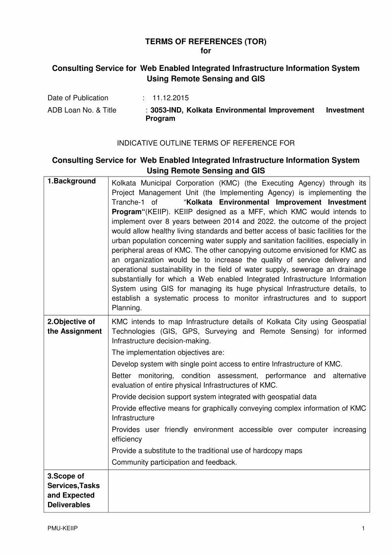
TERMS OF REFERENCES (TOR) for
Consulting Service for Web Enabled Integrated Infrastructure Information System
Using Remote Sensing and GIS
Date of Publication : 11.12.2015
ADB Loan No. & Title : 3053-IND, Kolkata Environmental Improvement Investment Program
INDICATIVE OUTLINE TERMS OF REFERENCE FOR
Consulting Service for Web Enabled Integrated Infrastructure Information System
Using Remote Sensing and GIS
1.Background Kolkata Municipal Corporation (KMC) (the Executing Agency) through its
Project Management Unit (the Implementing Agency) is implementing the
Tranche-1 of “Kolkata Environmental Improvement Investment
Program“(KEIIP). KEIIP designed as a MFF, which KMC would intends to
implement over 8 years between 2014 and 2022. the outcome of the project
would allow healthy living standards and better access of basic facilities for the
urban population concerning water supply and sanitation facilities, especially in
peripheral areas of KMC. The other canopying outcome envisioned for KMC as
an organization would be to increase the quality of service delivery and
operational sustainability in the field of water supply, sewerage an drainage
substantially for which a Web enabled Integrated Infrastructure Information
System using GIS for managing its huge physical Infrastructure details, to
establish a systematic process to monitor infrastructures and to support
Planning.
2.Objective of
the Assignment
KMC intends to map Infrastructure details of Kolkata City using Geospatial
Technologies (GIS, GPS, Surveying and Remote Sensing) for informed
Infrastructure decision-making.
The implementation objectives are:
Develop system with single point access to entire Infrastructure of KMC.
Better monitoring, condition assessment, performance and alternative
evaluation of entire physical Infrastructures of KMC.
Provide decision support system integrated with geospatial data
Provide effective means for graphically conveying complex information of KMC
Infrastructure
Provides user friendly environment accessible over computer increasing
efficiency
Provide a substitute to the traditional use of hardcopy maps
Community participation and feedback.
3.Scope of
Services,Tasks
and Expected
Deliverables
PMU-KEIIP 2
3.1 Scope of
Services,Tasks
and
Deliverables
The scope of the Work is to gather latest reliable spatial information using High
Resolution Images and non-spatial data, defining the locations & attributes of
assessed and un-assessed properties and municipal utility services (Water,
Drainage &Sewerage) appearing above and beneath ground in Wards with in
the KMC area.
Detailed Tasks
The activities include, but not limited to:
� Procurement of High Resolution Satellite Imagery of 0.5m or better.
� Create base map using High Resolution Satellite Imageries for 201
Sq. Km.
� Collection of input sources/data i.e. Primary & secondary.
secondary data from KMC, in soft/hard copy
� Data evaluation: Source and reliability, positional accuracy, attribute
authenticity
� Design of proper grid and projection in Universal Transverse
Mercator (UTM-WGS 84) coordinates based on Transverse Mercator
projection system for the area of interest.
� Geo-referencing of satellite imagery using sufficient number of
Ground Control Points (GCP) collected thru Differential Global Positioning
System (DGPS) survey.
� Interpretation and digitization of all physical features from satellite
imagery. The digitization process shall include vectorization,
symbolization, layering, edge matching, topological integrity, and data
base linking
� Geo-referencing and digitization of all secondary maps.
� Digitization of all Roads, Dividers, Bridges to maintain on regular
basis.
� Digitization of Water, Drainage and Sewerage Distribution
network.(Underground utilities will not be verified by using any
Instrument)
� Ground Truthing of Base map through field survey.
� Digitization / Capture of Infrastructure details.
� Consumer Survey and Map Updation
� Database structure and design;
� Install Software & DBMS required for deployment and functioning of
proposed solution.
� Study, design, development, configuration and implementation of
“Web enabled Integrated Infrastructure Information System using GIS”,
accessible by KMC.
� Application should support scalability
PMU-KEIIP 3
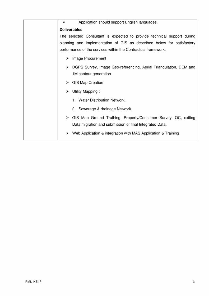
� Application should support English languages.
Deliverables
The selected Consultant is expected to provide technical support during
planning and implementation of GIS as described below for satisfactory
performance of the services within the Contractual framework:
� Image Procurement
� DGPS Survey, Image Geo-referencing, Aerial Triangulation, DEM and
1M contour generation
� GIS Map Creation
� Utility Mapping :
1. Water Distribution Network.
2. Sewerage & drainage Network.
� GIS Map Ground Truthing, Property/Consumer Survey, QC, exiting
Data migration and submission of final Integrated Data.
� Web Application & integration with MAS Application & Training
PMU-KEIIP 4
Municipal Transaction Processing System ( MTPS )
Municipal Management
Information System ( MMIS )
Citizens Interface System (Portal, CSC
& Kiosk)
Municipal Geographic Info. System (MGIS )
Municipal Data Bank (MDB)
Municipal Administration System (MAS)
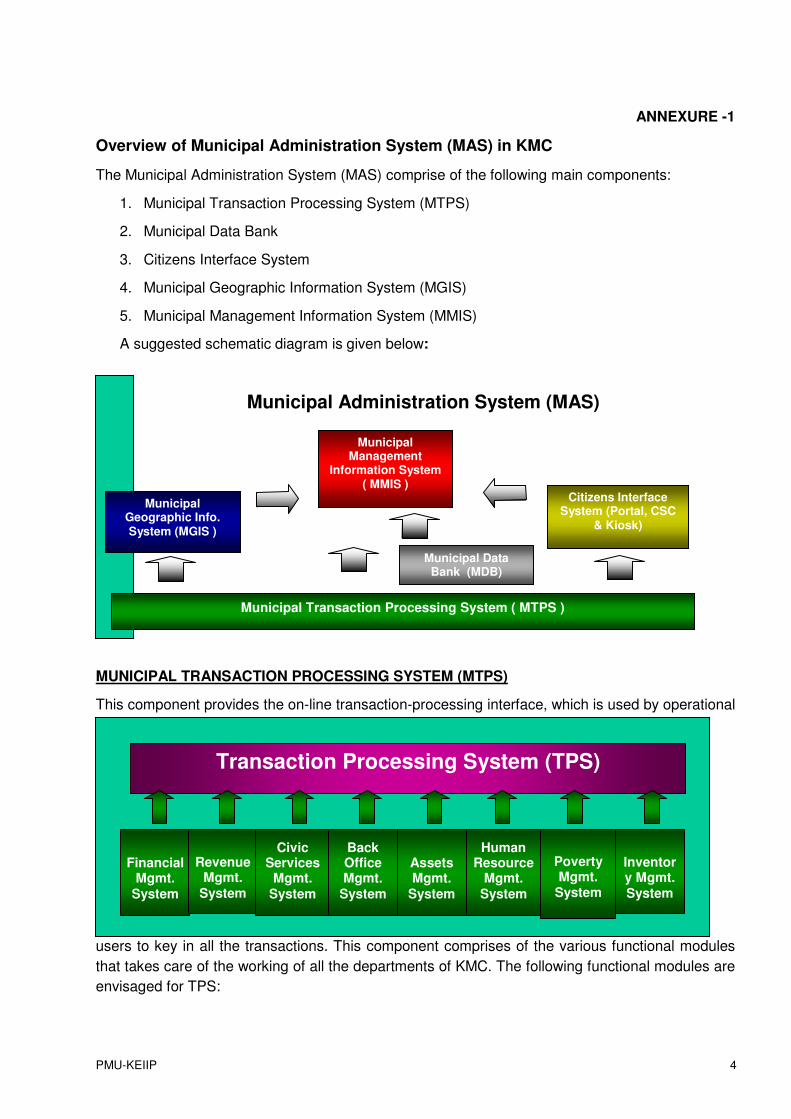
ANNEXURE -1
Overview of Municipal Administration System (MAS) in KMC
The Municipal Administration System (MAS) comprise of the following main components:
1. Municipal Transaction Processing System (MTPS)
2. Municipal Data Bank
3. Citizens Interface System
4. Municipal Geographic Information System (MGIS)
5. Municipal Management Information System (MMIS)
A suggested schematic diagram is given below:
MUNICIPAL TRANSACTION PROCESSING SYSTEM (MTPS)
This component provides the on-line transaction-processing interface, which is used by operational
users to key in all the transactions. This component comprises of the various functional modules
that takes care of the working of all the departments of KMC. The following functional modules are
envisaged for TPS:
Financial
Mgmt. System
Revenue Mgmt.
System
Inventory Mgmt. System
Assets Mgmt.
System
Human Resource
Mgmt. System
Civic Services
Mgmt. System
Back Office Mgmt.
System
Transaction Processing System (TPS)
Poverty Mgmt.
System

PMU-KEIIP 5
Financial Management System
This module covers the following functions:
• Finance
• Treasury
• Auditing
• Budgeting
Being the central module, this system is linked to all the other management systems. Any financial
transaction carried out in any department would automatically generate the required accounting
entry in this module.
Revenue Management System
This module covers the following functions:
• Property Tax
• Building Fees
• Trade License Fees
• Water Charges
• Drainage Observation Fee
• Leased Properties
• Market Stallage
• Advertisement
• Car parking
• Amusement Tax
• User Taxes
This module is linked to the Financial Management System as well as the relevant functions of the
different modules. For instance Water charges information would be made available to the Water
Supply engineering function under the Civic Services Management System. This module would
also be linked to the GIS and different revenues would be shown as different thematic layers.
Civic Services Management System
This module covers the following functions:
• Solid Waste Management
• Health
• Education
• Engineering
• Water Supply
PMU-KEIIP 6
• Sewerage & Drainage
• Planning & Design
• Lighting & Electricity
• Projects & Development
• Parks & Gardens.
• Wet Land.
This module is principally linked to the Financial Management Module. This module would also be
linked to the GIS and different public infrastructure details would be shown as different thematic
layers.
BackOffice Management System
This module covers the following functions:
• IT
• GIS
• Law
• Secretary
• Press & I&PR
• Vigilance & Corruption control
As the name suggest this module accesses information from all other modules and linked to the
Data Bank Component of MAS. The IT and GIS functions would naturally be linked to all other
components of MAS.
Assets Management System
This module covers the following functions:
• Estate Management
• Other Assets like Vehicles, Plant & Machinery, etc.
This module is principally linked to the Financial Management Module.
H. R. Management System
This module covers the following functions:
• HR Database
• Payroll
• Provident Fund
• Pensions Cell
This module is exclusively linked to the Financial Management Module.
Poverty Management System
This module covers the following functions:
• Poverty Database - Bustee Services
PMU-KEIIP 7
• Programs & Schemes
This module is linked to the Civic Services Management System as well as the relevant functions
of some other modules as well.
Inventory Management System
This module covers the following functions:
• Procurement
• Stores
• Supply
This module is linked to the Financial Management System and the Civic Services Management
System.
Municipal Data Bank (MDB)
A data warehouse is a collection of data designed to support decision-making and analytical
processing. This component is the data warehouse of KMC where all the documents like circulars,
contract agreements, lease deeds, etc. are stored electronically so that whenever required, these
can be viewed along with the transactional details produced by MTPS.
Citizens Interface Systems (CIS)
This interface provides information and services (such as payment of municipal taxes, lodging of
public grievances, etc.) to the citizens of Kolkata. This is done through KMC’s e-Kolkata Citizen
Service Centers as well as KMC’s current web site (https://www.kmcgov.in) and later on it would
be done through touch screen – voice based public access kiosks, which would be installed in
prominent public areas.
Municipal Geographic Information Systems (MGIS)
This component would provide the different thematic layers superimposed on the Base map of
Kolkata. Essentially the GIS would cover three important areas:
• Tax mapping - showing details of all municipal taxes and charges, like Property Tax,
Trade Licenses, Water charges, etc. levied on various assesses.
• Public Infrastructure mapping - showing the details of municipal infrastructure like
roads, street lights, and public taps etc.
• Poverty mapping –showing socio-economic attributes of the poor households.
The MGIS would use the same common Centralised database, which is created, and updated
using the MTPS system, so that there are no mismatches in information generated by the MMIS
and MGIS. Simply put, GIS has to be developed and used using the same data (MTPS) which the
MIS uses for generation of reports i.e., MIS provides a text and graphics based user interface for
viewing transactional information and GIS provides a spatial interface to see the same information.
A software module has also been developed for 16 different departments of KMC using ESRI-
ArcGIS, (ArcInfo, ArcIMS, ArcSDE version 9.3) Java and Oracle 10g have been used to develop
the existing system.
PMU-KEIIP 8
User department of KMC GIS System:
• Sewerage and Drainage
Department
• Engineering and Roads Department
• Town Planning Department
• Market Department
• Solid Waste Department
• Parking Department
• Parks and Squares Department
• Advertisement & Hoarding
Department
• Project Management Unit (PMU)
Department
• Bustee Services Department
• License Department
• AssessmentCollection
Department
• Water Supply Department
• Building Department
• Education Department
• Amusement Department
• Health Department
• Lighting Department
• Estate Management
Department
3.2 Training The scope of training shall include the following:
� Training & Capacity Building Onsite Support and Application
Maintenance.
� User training – both system administrator and end-user training
4.Team Composition & Qualification Requirements for the Key Experts
Estimated Input requirements
Key Experts
Sr.
No.
Key Expert Type Inputs In Person
Month
1 Team Leader/
Geospatial Expert
National 30
2 GIS Specialist National 30
3 Software developer National 12
4 DBA Expert National 15
Specific Tasks with Preferred Qualifications and Experiences of Key Persons The qualification described are to supplement the information already
provided in the Terms of reference (TOR) that directly or indirectly
defines the level and range of expertise, qualifications and experiences
to be possessed by the expert, and is, therefore, not an exhaustive list of
requirements.

PMU-KEIIP 9
Position Qualification, Experience, Tasks and Responsibilities Position Qualification &
Experience Tasks and Responsibilities
Team Leader/ Geospatial Expert
Ph.D. or Post graduate
university degree (Masters
or equivalent), in
Geography, , Remote
Sensing, Geo- Informatics
or Civil Engineering. 10
Plus years of
progressively responsible
experience in surveying,
planning, designing,
development and
implementation in GIS
project/ applications.
Working experience in
externally aided
assignments in urban area
is preferred. Excellent
English language skills
The expert will be
responsible for
ensuring satisfactory
performance the entire
Project.
(a) System
requirement Study
(SRS), System
Analysis & Design,
Development of
customized Web base
GIS application,
Collection of input,
Data evaluation,
Design of proper grid
and projection,
Interpretation and
Geo-referencing and
digitization.
(b) Design,
development,
Configuration and
implementation of web
application.
(c) System &User
Documents.
GIS Specialist
Post graduate university
degree (Masters or
equivalent in Geography,
Remote sensing, Geo-
Informatics. or Planning
and 10 years working
experience in remote
sensing and GIS. Working
experience in externally
aided assignments in
urban area is preferred.
Excellent English
language skills.
The expert will be
responsible for
Mapping, Consumer
Survey & Data
Collection, Data
Migration, &
Integration, Training,
Web Application,
Vendor Management
and Data – QA/QC.
PMU-KEIIP 10
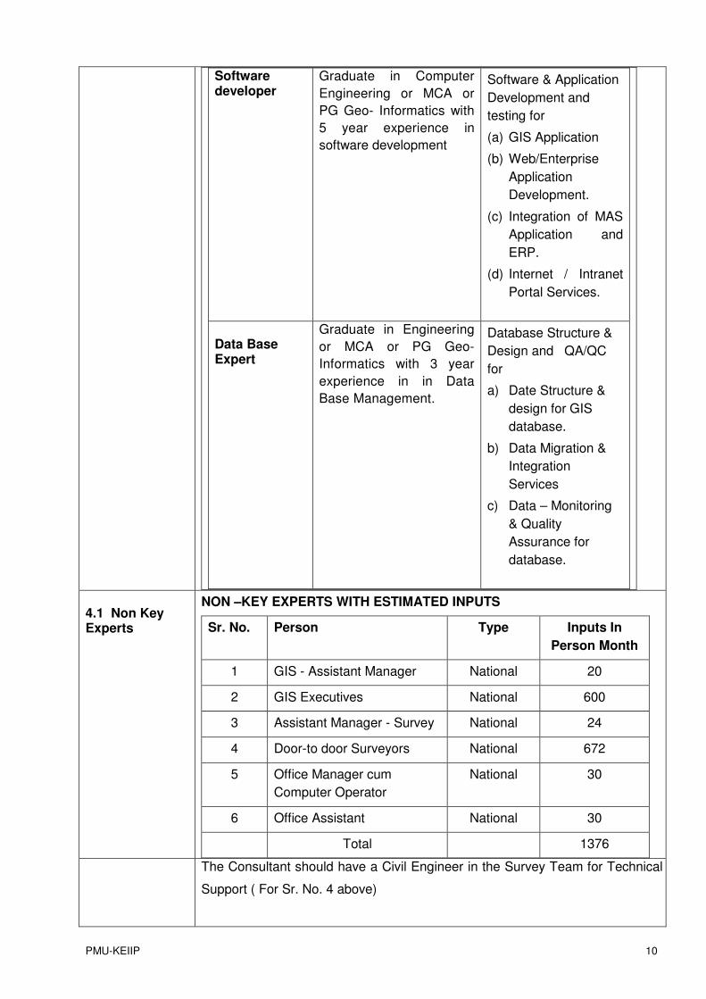
Software developer
Graduate in Computer
Engineering or MCA or
PG Geo- Informatics with
5 year experience in
software development
Software & Application
Development and
testing for
(a) GIS Application
(b) Web/Enterprise
Application
Development.
(c) Integration of MAS
Application and
ERP.
(d) Internet / Intranet
Portal Services.
Data Base Expert
Graduate in Engineering
or MCA or PG Geo-
Informatics with 3 year
experience in in Data
Base Management.
Database Structure &
Design and QA/QC
for
a) Date Structure &
design for GIS
database.
b) Data Migration &
Integration
Services
c) Data – Monitoring
& Quality
Assurance for
database.
4.1 Non Key Experts
NON –KEY EXPERTS WITH ESTIMATED INPUTS
Sr. No. Person Type Inputs In
Person Month
1 GIS - Assistant Manager National 20
2 GIS Executives National 600
3 Assistant Manager - Survey National 24
4 Door-to door Surveyors National 672
5 Office Manager cum
Computer Operator
National 30
6 Office Assistant National 30
Total 1376
The Consultant should have a Civil Engineer in the Survey Team for Technical
Support ( For Sr. No. 4 above)
PMU-KEIIP 11
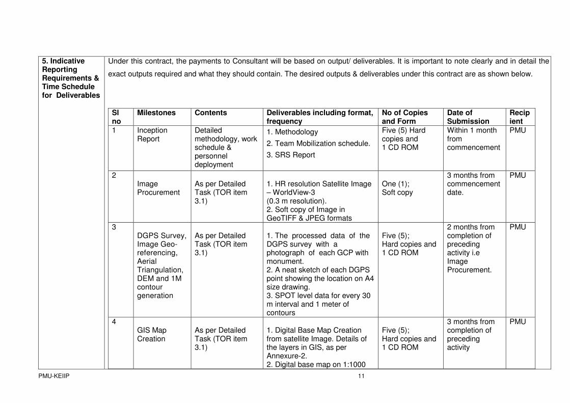
5. Indicative Reporting Requirements & Time Schedule for Deliverables
Under this contract, the payments to Consultant will be based on output/ deliverables. It is important to note clearly and in detail the
exact outputs required and what they should contain. The desired outputs & deliverables under this contract are as shown below.
Sl no
Milestones Contents Deliverables including format, frequency
No of Copies and Form
Date of Submission
Recipient
1 Inception Report
Detailed methodology, work schedule & personnel deployment
1. Methodology
2. Team Mobilization schedule.
3. SRS Report
Five (5) Hard copies and 1 CD ROM
Within 1 month from commencement
PMU
2 Image Procurement
As per Detailed Task (TOR item 3.1)
1. HR resolution Satellite Image – WorldView-3 (0.3 m resolution). 2. Soft copy of Image in GeoTIFF & JPEG formats
One (1); Soft copy
3 months from commencement date.
PMU
3 DGPS Survey, Image Geo-referencing, Aerial Triangulation, DEM and 1M contour generation
As per Detailed Task (TOR item 3.1)
1. The processed data of the DGPS survey with a photograph of each GCP with monument. 2. A neat sketch of each DGPS point showing the location on A4 size drawing. 3. SPOT level data for every 30 m interval and 1 meter of contours
Five (5); Hard copies and 1 CD ROM
2 months from completion of preceding activity i.e Image Procurement.
PMU
4 GIS Map Creation
As per Detailed Task (TOR item 3.1)
1. Digital Base Map Creation from satellite Image. Details of the layers in GIS, as per Annexure-2. 2. Digital base map on 1:1000
Five (5); Hard copies and 1 CD ROM
3 months from completion of preceding activity
PMU
PMU-KEIIP 12
scale. 3. Spatial database will be designed as per the GIS requirements outlined in the SRS document. 4. Digital data of base map in .shp & Personal Geo-database (PGDB). In case of bigger size the data should be delivered in File Geo-database (FGDB) format.
5. Hard copies of Ward wise
Maps, depicting all entities to be
delivered.
6. Geo-PDFs of the base map of
each ward depicting all layers.
5 Utility Mapping for -
5.1
� Water Distribution Network.
As per Detailed Task (TOR item 3.1)
1. Digital Base Map of Water Distribution Network with layers as per Annexure-2. 2. Network Digitization & Superimposition on Base Map. 2. Utility Surveyed Data in excel
Five (5); Hard copies and 1 CD ROM
PMU
PMU-KEIIP 13
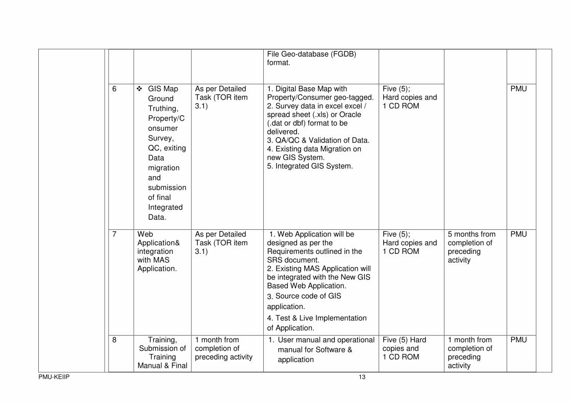
File Geo-database (FGDB) format.
6 � GIS Map
Ground
Truthing,
Property/C
onsumer
Survey,
QC, exiting
Data
migration
and
submission
of final
Integrated
Data.
As per Detailed Task (TOR item 3.1)
1. Digital Base Map with Property/Consumer geo-tagged. 2. Survey data in excel excel / spread sheet (.xls) or Oracle (.dat or dbf) format to be delivered. 3. QA/QC & Validation of Data. 4. Existing data Migration on new GIS System. 5. Integrated GIS System.
Five (5); Hard copies and 1 CD ROM
PMU
7 Web Application& integration with MAS Application.
As per Detailed Task (TOR item 3.1)
1. Web Application will be designed as per the Requirements outlined in the SRS document. 2. Existing MAS Application will be integrated with the New GIS Based Web Application.
3. Source code of GIS
application.
4. Test & Live Implementation
of Application.
Five (5); Hard copies and 1 CD ROM
5 months from completion of preceding activity
PMU
8 Training, Submission of
Training Manual & Final
1 month from completion of preceding activity
1. User manual and operational
manual for Software &
application
Five (5) Hard copies and 1 CD ROM
1 month from completion of preceding activity
PMU
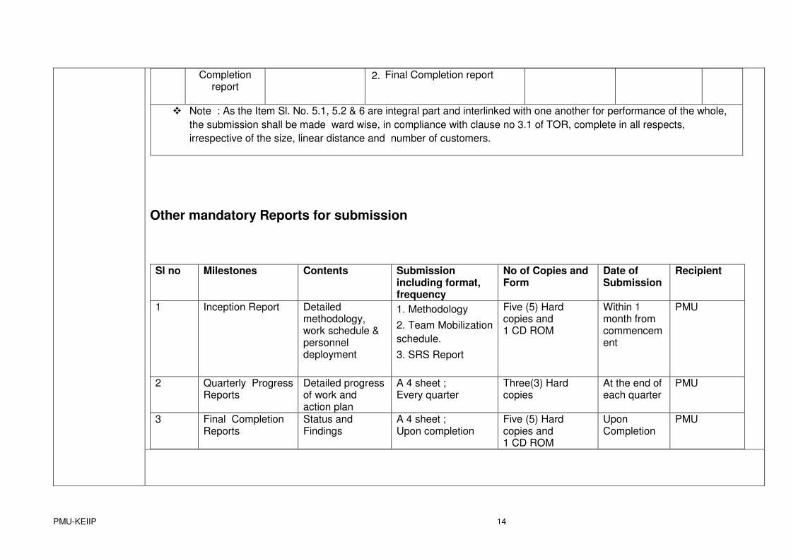
PMU-KEIIP 14
Completion report
2. Final Completion report
� Note : As the Item Sl. No. 5.1, 5.2 & 6 are integral part and interlinked with one another for performance of the whole,
the submission shall be made ward wise, in compliance with clause no 3.1 of TOR, complete in all respects,
irrespective of the size, linear distance and number of customers.
Other mandatory Reports for submission
Sl no Milestones Contents Submission including format, frequency
No of Copies and Form
Date of Submission
Recipient
1 Inception Report Detailed methodology, work schedule & personnel deployment
1. Methodology
2. Team Mobilization
schedule.
3. SRS Report
Five (5) Hard copies and 1 CD ROM
Within 1 month from commencement
PMU
2 Quarterly Progress Reports
Detailed progress of work and action plan
A 4 sheet ; Every quarter
Three(3) Hard copies
At the end of each quarter
PMU
3 Final Completion Reports
Status and Findings
A 4 sheet ; Upon completion
Five (5) Hard copies and 1 CD ROM
Upon Completion
PMU
PMU-KEIIP 15
ANNEXURE -2
DETAILS OF THE LAYERS IN GIS
S.N. Category
Layer Name
Vector Representation
Data Source Attribute Data Remarks
1 Municipal Boundary
Polygon KMC, Satellite Image ID and KMC Name Provided by KMC
2 Area of Interest Boundary
Polygon KMC, Satellite Image KMC Name Provided by KMC
3 Ward Boundary Polygon KMC, Satellite Image ID, Ward No. and Ward Name, Population-2010
Provided by KMC
4 Restricted Area Polygon KMC, Satellite Image ID, Name Provided by KMC
5 Borough Boundary
Polygon KMC, Satellite Image ID, Borough No., Borough Name Provided by KMC
6 Industrial Zones/Area
Polygon KMC, Satellite Image ID, Locality Name Provided by KMC
9 Slum Boundary Polygon KMC, Satellite Image ID, Slum No., Locality Provided by KMC
10 Water Supply Zone
Polygon KMC, Satellite Image ID, Zone No, Zone name Provided by KMC
11 Sewerage Zone Polygon KMC, Satellite Image ID, Zone No, Zone name Provided by KMC
12 Sewerage Sub-Zone
Polygon KMC, Satellite Image ID, Zone No, Zone name Provided by KMC
13
Administrative
Storm Water catchment, Sub-catchment Boundary
Polygon KMC, Satellite Image ID, catchment No, catchment name
Provided by KMC
14 Railway Line Existing data, Satellite Image and Field Survey
ID, Type Broad Gauge/Meter Gauge
15 Station/Platform/Yard
Polygon Existing data, Satellite Image and Field Survey
ID, Type, Name Station/Platform/Yard
16
Transport (Railway)
Overhead footbridge
Line Existing data, Satellite Image and Field Survey
ID, Type, Name
PMU-KEIIP 16
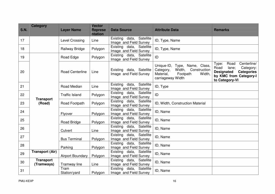
S.N. Category
Layer Name
Vector Representation
Data Source Attribute Data Remarks
17 Level Crossing Line Existing data, Satellite Image and Field Survey
ID, Type, Name
18
Railway Bridge Polygon Existing data, Satellite Image and Field Survey
ID, Type, Name
19 Road Edge Polygon Existing data, Satellite Image and Field Survey
ID
20 Road Centerline Line Existing data, Satellite Image and Field Survey
Unique-ID, Type, Name, Class, Category, Width, Construction Material, Footpath Width, carriageway Width
Type: Road Centerline/ Road lane; Category: Designated Categories by KMC from Category-I to Category-VI
21 Road Median Line Existing data, Satellite Image and Field Survey
ID, Type
22 Traffic Island Polygon Existing data, Satellite Image and Field Survey
ID
23 Road Footpath Polygon Existing data, Satellite Image and Field Survey
ID, Width, Construction Material
24 Flyover Polygon
Existing data, Satellite Image and Field Survey
ID, Name
25 Road Bridge Polygon
Existing data, Satellite Image and Field Survey
ID, Name
26 Culvert Line
Existing data, Satellite Image and Field Survey
ID, Name
27 Bus Terminal Polygon
Existing data, Satellite Image and Field Survey
ID, Name
28
Transport (Road)
Parking Polygon
Existing data, Satellite Image and Field Survey
ID, Name
29 Transport (Air)
Airport Boundary Polygon
Existing data, Satellite Image and Field Survey
ID, Name
30 Tramway line Line
Existing data, Satellite Image and Field Survey
ID, Name
31
Transport (Tramways)
Tram Station/yard Polygon
Existing data, Satellite Image and Field Survey
ID, Name
PMU-KEIIP 17
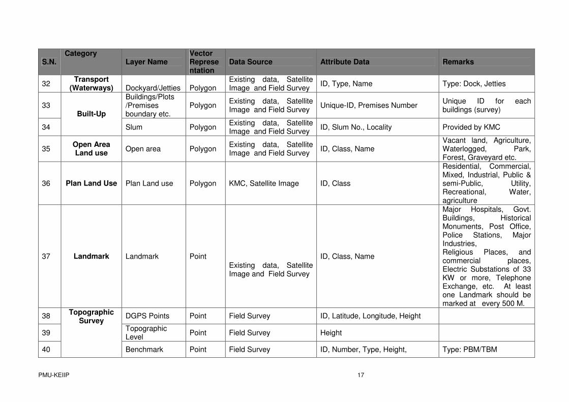
S.N. Category
Layer Name
Vector Representation
Data Source Attribute Data Remarks
32 Transport
(Waterways) Dockyard/Jetties Polygon
Existing data, Satellite Image and Field Survey
ID, Type, Name Type: Dock, Jetties
33
Buildings/Plots /Premises boundary etc.
Polygon Existing data, Satellite Image and Field Survey
Unique-ID, Premises Number Unique ID for each buildings (survey)
34
Built-Up
Slum Polygon Existing data, Satellite Image and Field Survey
ID, Slum No., Locality Provided by KMC
35 Open Area Land use
Open area Polygon Existing data, Satellite Image and Field Survey
ID, Class, Name
Vacant land, Agriculture, Waterlogged, Park, Forest, Graveyard etc.
36 Plan Land Use Plan Land use Polygon KMC, Satellite Image ID, Class
Residential, Commercial, Mixed, Industrial, Public & semi-Public, Utility, Recreational, Water, agriculture
37 Landmark Landmark Point
Existing data, Satellite Image and Field Survey
ID, Class, Name
Major Hospitals, Govt. Buildings, Historical Monuments, Post Office, Police Stations, Major Industries, Religious Places, and commercial places, Electric Substations of 33 KW or more, Telephone Exchange, etc. At least one Landmark should be marked at every 500 M.
38 DGPS Points Point Field Survey ID, Latitude, Longitude, Height
39 Topographic Level
Point Field Survey Height
40
Topographic Survey
Benchmark Point Field Survey ID, Number, Type, Height, Type: PBM/TBM

PMU-KEIIP 18
S.N. Category
Layer Name
Vector Representation
Data Source Attribute Data Remarks
41
Contours Line Field Survey ID, Height Generated at 0.5 M interval
42 River Line Existing data, Satellite Image and Field Survey
ID, Type, Name
43 Stream/Canal/Drainage
Line Existing data, Satellite Image and Field Survey
ID, Type, Name
44
Fresh Water
Pond/Tank Polygon Existing data, Satellite Image and Field Survey
ID, Type, Name
45 Water Supply Network
Line
46 Junction/Valve Point
47 Laterals Line
48 Fittings Point
49 House Connection
Line
50 Hydrant Point
51 Monitoring Point
ID, Name, Ward/Zone
52 Over Head Tanks
Polygon
ID, Ward No., Locality, ,Capacity, Status, Water Supply Zone & Sub-Zone
53 Water Pumping Station
Point ID, Type, Capacity, Status, Maintenance Schedule
54
Water Supply Network
Water treatment plant
Point
KMC, Satellite Image and Field Survey
ID, Road ID, Capacity, Ward, Locality, Description
It should be marked with the help of Staff of Concern department/Field Survey
55 Landfill Site Polygon KMC, Satellite Image and Field Survey
ID, Type, Road ID, Ward No., Locality
56
Sanitation Garbage Collection Points
Point KMC, Satellite Image and Field Survey
ID, Road ID, Ward, Locality, Garbage Collection Points and Transfer points
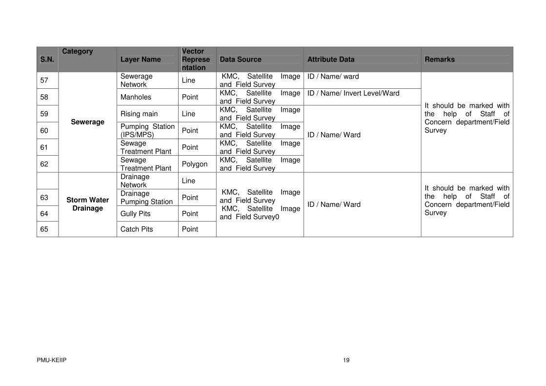
PMU-KEIIP 19
S.N. Category
Layer Name
Vector Representation
Data Source Attribute Data Remarks
57 Sewerage Network
Line KMC, Satellite Image and Field Survey
ID / Name/ ward
58 Manholes Point KMC, Satellite Image and Field Survey
ID / Name/ Invert Level/Ward
59 Rising main Line KMC, Satellite Image and Field Survey
60 Pumping Station (IPS/MPS)
Point KMC, Satellite Image and Field Survey
61 Sewage Treatment Plant
Point KMC, Satellite Image and Field Survey
62
Sewerage
Sewage Treatment Plant
Polygon KMC, Satellite Image and Field Survey
ID / Name/ Ward
It should be marked with the help of Staff of Concern department/Field Survey
Drainage Network
Line
63 Drainage Pumping Station
Point
64 Gully Pits Point
65
Storm Water Drainage
Catch Pits Point
KMC, Satellite Image and Field Survey
KMC, Satellite Image and Field Survey0
ID / Name/ Ward
It should be marked with the help of Staff of Concern department/Field Survey
PMU-KEIIP 20
Abbreviation:
1. AOI - Area of Interest
2. AMC - Annual Maintenance Contract
3. DBA - Data Base Administrator
4. DBMS - Database Management System
5. DEM - Digital Elevation Model
6. DGPS – Differential Global Positioning System
7. ERP - Enterprise Resource Planning
8. FGDB – File Geodatabase
9. GCP – Ground Control Points
10. GIS – Geographical Information System.
11. GPS – Global Positioning System.
12. HHC - Hand Held Computer
13. IT - Information Technology
14. ITES - Information Technology Enterprise Solution
15. KMC - Kolkata Municipal Corporation
16. LDAP – Lightweight Directory Access Protocol.
17. MAS - Municipal Administration System
18. NDA - Non-disclosure Agreement
19. NRSC - National Remote Sensing Centre
20. NSDI - National Spatial Data Infrastructure
21. NUIS - National Urban Information System
22. PDA - Personal Digital Assistants
23. PGDB – Personal Geodatabase
24. PMU - Project Management Unit.

PMU-KEIIP 21
25. RDBMS – Relational Database Management System
26. RFP - Request for Proposal
27. RS – Remote Sensing.
28. SRS - System Requirement Specification.
29. UAT - User Acceptance Testing
PMU-KEIIP 22
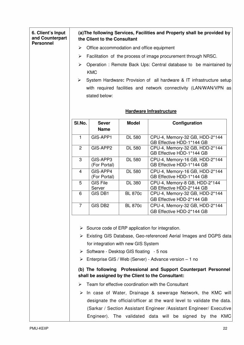
6. Client’s Input and Counterpart Personnel
(a)The following Services, Facilities and Property shall be provided by
the Client to the Consultant
� Office accommodation and office equipment
� Facilitation of the process of image procurement through NRSC.
� Operation : Remote Back Ups: Central database to be maintained by
KMC
� System Hardware: Provision of all hardware & IT infrastructure setup
with required facilities and network connectivity (LAN/WAN/VPN as
stated below:
Hardware Infrastructure
Sl.No. Sever
Name
Model Configuration
1 GIS-APP1 DL 580 CPU-4, Memory-32 GB, HDD-2*144 GB Effective HDD-1*144 GB
2 GIS-APP2 DL 580 CPU-4, Memory-32 GB, HDD-2*144 GB Effective HDD-1*144 GB
3 GIS-APP3 (For Portal)
DL 580 CPU-4, Memory-16 GB, HDD-2*144 GB Effective HDD-1*144 GB
4 GIS-APP4 (For Portal)
DL 580 CPU-4, Memory-16 GB, HDD-2*144 GB Effective HDD-1*144 GB
5 GIS File Server
DL 380 CPU-4, Memory-8 GB, HDD-2*144 GB Effective HDD-2*144 GB
6 GIS DB1 BL 870c CPU-4, Memory-32 GB, HDD-2*144
GB Effective HDD-2*144 GB
7 GIS DB2 BL 870c CPU-4, Memory-32 GB, HDD-2*144
GB Effective HDD-2*144 GB
� Source code of ERP application for integration.
� Existing GIS Database, Geo-referenced Aerial Images and DGPS data
for integration with new GIS System
� Software - Desktop GIS floating - 5 nos
� Enterprise GIS / Web (Server) - Advance version – 1 no
(b) The following Professional and Support Counterpart Personnel
shall be assigned by the Client to the Consultant:
� Team for effective coordination with the Consultant
� In case of Water, Drainage & sewerage Network, the KMC will
designate the official/officer at the ward level to validate the data.
(Sarkar / Section Assistant Engineer /Assistant Engineer/ Executive
Engineer). The validated data will be signed by the KMC
PMU-KEIIP 23
official/officer. The data validate and signed by KMC official/officer
will be the part of Base Map.
7. Client will provide the following inputs, project data and reports to facilitate preparation of the Proposals
The Client will provide all the available reports and documents for the study of
the consultants. The client will also assist the consultants to obtain requisite
available information from any other department/organisation. However the
responsibility of such collection would lie with the consultants.
The following are the existing system available with the KMC which shall be
shared:
� KMC has already developed a portion of the GIS system which
is running on KMC Central Server environment in year 2001.
� The digital base map of KMC area is on 1:500 scale (contour
interval-half meter) was compiled using Aerial photogrammetry
by NRSA under Mega City Plan.
� The digital Map with data base is ready for 41 wards out of 144
wards with basic features of Urban Area.
� A software module has also been developed for 16 different
departments of KMC using ESRI- ArcGIS, (ArcInfo, ArcIMS,
ArcSDE version 9.3) Java and Oracle 10g have been used to
develop the existing system.
� An integrated departmental Municipal Administration System
(MAS) data (non-spatial data) into the GIS system to execute
the departmental queries