
THE KINGDOM OF BHUTAN THE PROJECT FOR ...open_jicareport.jica.go.jp/pdf/12286613.pdf2.4.2 Bhutanese...
333
The Kingdom of Bhutan Ministry of Economic Affairs THE KINGDOM OF BHUTAN THE PROJECT FOR CAPACITY DEVELOPMENT OF GLOF AND RAINSTORM FLOOD FORECASTING AND EARLY WARNING PROJECT COMPLETION REPORT SEPTEMBER 2016 Japan International Cooperation Agency (JICA) Earth System Science Co. Ltd. GE JR 16-114
Transcript of THE KINGDOM OF BHUTAN THE PROJECT FOR ...open_jicareport.jica.go.jp/pdf/12286613.pdf2.4.2 Bhutanese...
The Kingdom of Bhutan Ministry of Economic Affairs
THE KINGDOM OF BHUTAN
THE PROJECT FOR CAPACITY DEVELOPMENT OF
GLOF AND RAINSTORM FLOOD FORECASTING AND EARLY WARNING
PROJECT COMPLETION REPORT
SEPTEMBER 2016
Japan International Cooperation Agency
(JICA) Earth System Science Co. Ltd.
GE
JR
16-114


The Project for Capacity Development of GLOF and Rainstorm Flood Forecasting and Early Warning in the Kingdom of Bhutan
Project Completion Report
- I -
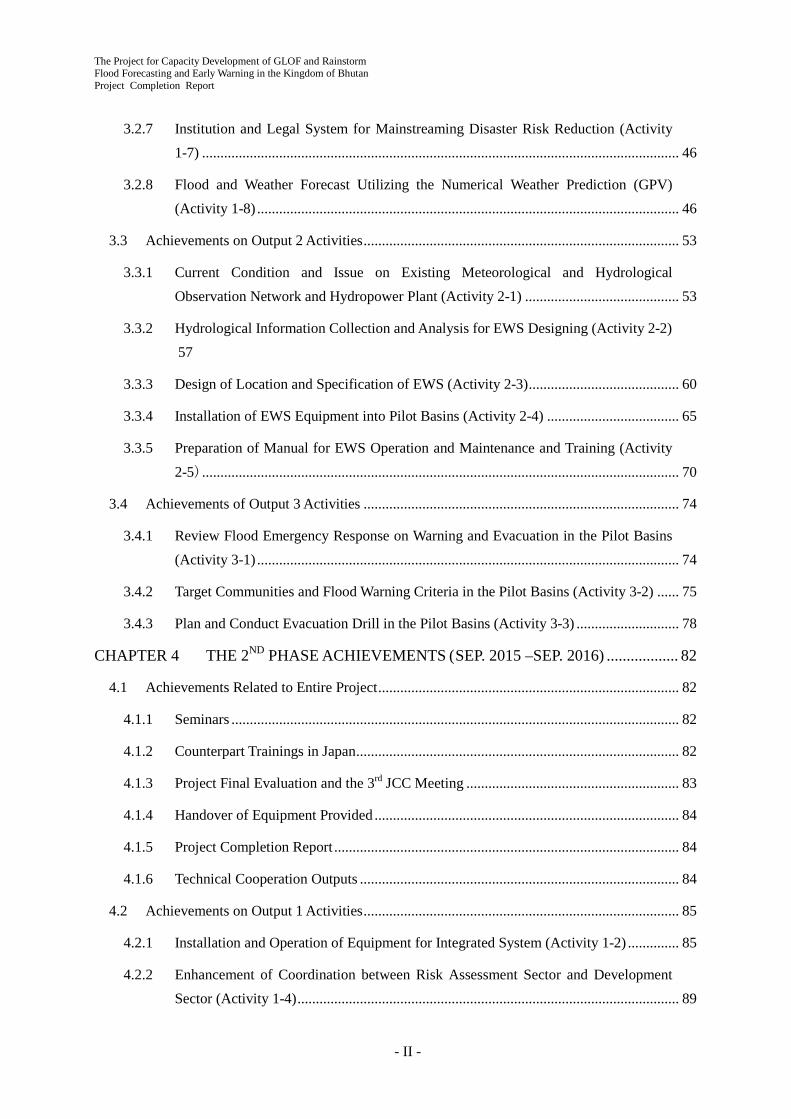
Table of Contents
INTRODUCTION ............................................................................................ 1 CHAPTER 1
1.1 General ...................................................................................................................................... 1
1.2 Project Area ............................................................................................................................... 1
1.3 Target Beneficiary Population ................................................................................................... 2
METHODOLOGY OF PROJECT IMPLEMENTATION ............................. 3 CHAPTER 2
2.1 Project Purpose, Outputs and Activities .................................................................................... 3
2.2 Implementation Structure .......................................................................................................... 4
2.3 Implementation Schedule .......................................................................................................... 5
2.4 Input .......................................................................................................................................... 7
2.4.1 Japanese Side Input ........................................................................................................... 7
2.4.2 Bhutanese Side Input ......................................................................................................... 8
THE 1ST PHASE ACHIEVEMENTS (SEP. 2013 - JUL. 2015) .................... 9 CHAPTER 3
3.1 Achievements Related to Entire Project .................................................................................... 9
3.1.1 Discussion with Bhutanese Side ........................................................................................ 9
3.1.2 Related Projects by Other Donors ................................................................................... 10
3.1.3 Baseline Survey ................................................................................................................11
3.1.4 1st Annual Seminar .......................................................................................................... 19
3.1.5 Counterpart Trainings in Japan ........................................................................................ 19
3.1.6 Project Mid-Term Review and the 2nd JCC Meeting ..................................................... 20
3.2 Achievements on Output 1 Activities ...................................................................................... 20
3.2.1 Present State of Existing Hydro-Met Data, Monitoring and Warning (Activity 1-1) ...... 21
3.2.2 Installation and Operation of Equipment for Integrated System (Activity 1-2) .............. 26
3.2.3 Runoff and Flood Analysis Considering GLOF and Climate Change (Activity 1-3) ..... 31
3.2.4 Enhancement of Coordination between Risk Assessment Sector and Development Sector (Activity 1-4) ........................................................................................................ 39
3.2.5 Preparation and Improvement of Hazard Map through Training (Activity 1-5) ............. 40
3.2.6 Awareness Raising on Land Use Management against Disaster (Activity 1-6) .............. 44
The Project for Capacity Development of GLOF and Rainstorm Flood Forecasting and Early Warning in the Kingdom of Bhutan Project Completion Report
- II -
3.2.7 Institution and Legal System for Mainstreaming Disaster Risk Reduction (Activity 1-7) .................................................................................................................................. 46
3.2.8 Flood and Weather Forecast Utilizing the Numerical Weather Prediction (GPV) (Activity 1-8) ................................................................................................................... 46
3.3 Achievements on Output 2 Activities ...................................................................................... 53
3.3.1 Current Condition and Issue on Existing Meteorological and Hydrological Observation Network and Hydropower Plant (Activity 2-1) .......................................... 53
3.3.2 Hydrological Information Collection and Analysis for EWS Designing (Activity 2-2) 57
3.3.3 Design of Location and Specification of EWS (Activity 2-3) ......................................... 60
3.3.4 Installation of EWS Equipment into Pilot Basins (Activity 2-4) .................................... 65
3.3.5 Preparation of Manual for EWS Operation and Maintenance and Training (Activity 2-5) .................................................................................................................................. 70
3.4 Achievements of Output 3 Activities ...................................................................................... 74
3.4.1 Review Flood Emergency Response on Warning and Evacuation in the Pilot Basins (Activity 3-1) ................................................................................................................... 74
3.4.2 Target Communities and Flood Warning Criteria in the Pilot Basins (Activity 3-2) ...... 75
3.4.3 Plan and Conduct Evacuation Drill in the Pilot Basins (Activity 3-3) ............................ 78
THE 2ND PHASE ACHIEVEMENTS (SEP. 2015 –SEP. 2016) .................. 82 CHAPTER 4
4.1 Achievements Related to Entire Project .................................................................................. 82
4.1.1 Seminars .......................................................................................................................... 82
4.1.2 Counterpart Trainings in Japan ........................................................................................ 82
4.1.3 Project Final Evaluation and the 3rd JCC Meeting .......................................................... 83
4.1.4 Handover of Equipment Provided ................................................................................... 84
4.1.5 Project Completion Report .............................................................................................. 84
4.1.6 Technical Cooperation Outputs ....................................................................................... 84
4.2 Achievements on Output 1 Activities ...................................................................................... 85
4.2.1 Installation and Operation of Equipment for Integrated System (Activity 1-2) .............. 85
4.2.2 Enhancement of Coordination between Risk Assessment Sector and Development Sector (Activity 1-4) ........................................................................................................ 89

The Project for Capacity Development of GLOF and Rainstorm Flood Forecasting and Early Warning in the Kingdom of Bhutan
Project Completion Report
- III -
4.2.3 Preparation and Improvement of Hazard Map through Training (Activity 1-5) ............. 89
4.2.4 Institution and Legal System for Mainstreaming Disaster Risk Reduction (Activity 1-7) .................................................................................................................................. 91
4.2.5 Flood and Weather Forecast Utilizing the Numerical Weather Prediction (GPV) (Activity 1-8) ................................................................................................................... 92
4.2.6 SOP on Emergency Information Sharing at Central Level (Activity 1-9)....................... 94
4.3 Achievements on Output 2 Activities ...................................................................................... 95
4.3.1 Installation of EWS Equipment in the Pilot Basins (Activity 2-4) .................................. 96
4.3.2 Preparation of Manual for EWS Operation and Maintenance and Training (Activity 2-5) .................................................................................................................................. 97
4.4 Achievements on Output 3 Activities .................................................................................... 104
4.4.1 Plan and Conduct Evacuation Drill in the Pilot Basins (Activity 3-3) .......................... 104
4.4.2 SOP on Emergency Information Sharing in the Basins (Activity 3-4) .......................... 109
CHANGE IN COUNTERPART STATE BY TECHNICAL TRANSFER . 112 CHAPTER 5
ACHIEVEMENT OF THE PROJECT PURPOSE .................................... 118 CHAPTER 6
6.1 Achievements of Outputs .......................................................................................................118
6.2 Achievement of the Project Purpose ..................................................................................... 120
ISSUES AND LESSONS LEARNED ....................................................... 122 CHAPTER 7
7.1 GTS/MSS and EWS Installation ........................................................................................... 122
7.2 Overall Activities ................................................................................................................... 122
7.3 DDM/ DHMS Support for District Government on EWS Sensitization ............................... 122
RECOMMENDATIONS TO ACHIEVE OVERALL GOAL.................... 124 CHAPTER 8
Appendix Appendix 1 Record of Discussions Appendix 2 Project PDM and PO Appendix 3 Counterpart List Appendix 4 Minutes of Meetings of Inception Report Appendix 5 Minutes of Meetings of 1st Joint Coordinating Committee (JCC) Meeting
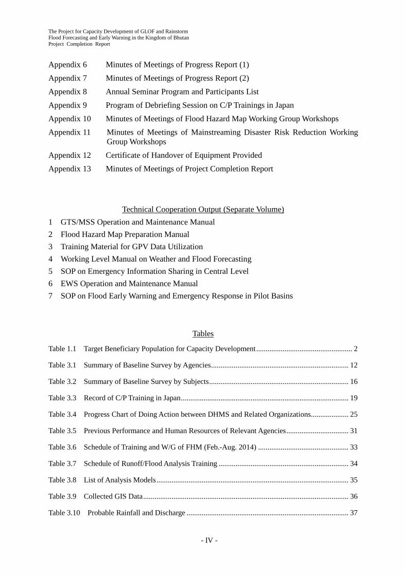
The Project for Capacity Development of GLOF and Rainstorm Flood Forecasting and Early Warning in the Kingdom of Bhutan Project Completion Report
- IV -
Appendix 6 Minutes of Meetings of Progress Report (1) Appendix 7 Minutes of Meetings of Progress Report (2) Appendix 8 Annual Seminar Program and Participants List Appendix 9 Program of Debriefing Session on C/P Trainings in Japan Appendix 10 Minutes of Meetings of Flood Hazard Map Working Group Workshops Appendix 11 Minutes of Meetings of Mainstreaming Disaster Risk Reduction Working
Group Workshops Appendix 12 Certificate of Handover of Equipment Provided Appendix 13 Minutes of Meetings of Project Completion Report
Technical Cooperation Output (Separate Volume)
1 GTS/MSS Operation and Maintenance Manual 2 Flood Hazard Map Preparation Manual 3 Training Material for GPV Data Utilization 4 Working Level Manual on Weather and Flood Forecasting 5 SOP on Emergency Information Sharing in Central Level 6 EWS Operation and Maintenance Manual 7 SOP on Flood Early Warning and Emergency Response in Pilot Basins
Tables
Table 1.1 Target Beneficiary Population for Capacity Development ................................................... 2
Table 3.1 Summary of Baseline Survey by Agencies ......................................................................... 12
Table 3.2 Summary of Baseline Survey by Subjects .......................................................................... 16
Table 3.3 Record of C/P Training in Japan ......................................................................................... 19
Table 3.4 Progress Chart of Doing Action between DHMS and Related Organizations .................... 25
Table 3.5 Previous Performance and Human Resources of Relevant Agencies ................................. 31
Table 3.6 Schedule of Training and W/G of FHM (Feb.-Aug. 2014) ................................................ 33
Table 3.7 Schedule of Runoff/Flood Analysis Training ..................................................................... 34
Table 3.8 List of Analysis Models ...................................................................................................... 35
Table 3.9 Collected GIS Data ............................................................................................................. 36
Table 3.10 Probable Rainfall and Discharge ...................................................................................... 37

The Project for Capacity Development of GLOF and Rainstorm Flood Forecasting and Early Warning in the Kingdom of Bhutan
Project Completion Report
- V -
Table 3.11 Total Number of Buildings in Simulated Flood Area ....................................................... 39
Table 3.12 Comments of the C/P Agencies on Flood Hazard Mapping ............................................. 43
Table 3.13 Records of C/P Trainings, Lectures and OJTs (Dec. 2014-Jul. 2015) .............................. 44
Table 3.14 Annual Rainfall and Specific Discharge ........................................................................... 54
Table 3.15 Salient Features of Mangdechhu and Chamkharchhu-I Hydropower Projects ................. 56
Table 3.16 Emergency Event Level and Action to be Taken in EAP ................................................. 57
Table 3.17 Field Inspection Schedule ................................................................................................. 58
Table 3.18 Planned Frequency Allocation of the EWS ...................................................................... 62
Table 3.19 Proposed Installation Sites of Flood Warning Siren Towers ............................................ 63
Table 3.20 Preparation of Tendering Documents ............................................................................... 65
Table 3.21 Schedule of Preliminary Site Survey ................................................................................ 66
Table 3.22 Verification of the Thresholds at Each Site ...................................................................... 70
Table 3.23 Activity Process on Preparation of EWS O&M Manual .................................................. 71
Table 3.24 Contents and Progress of EWS Operation and Maintenance Manual .............................. 73
Table 3.25 Number of Participants for Kick-off Meeting .................................................................. 75
Table 3.26 Preliminary Information for Selecting Target Communities for CBDRM ....................... 76
Table 3.27 Summary Description of Target Communities ................................................................. 77
Table 3.28 Target Communities and Activities................................................................................... 78
Table 3.29 Evacuation Equipment List .............................................................................................. 80
Table 3.30 Number of Participants in CBDRM Workshops ............................................................... 81
Table 4.1 Record of C/P Training in Japan ......................................................................................... 82
Table 4.2 Equipment Provided ........................................................................................................... 84
Table 4.3 Contents of Operation and Maintenance Manual ............................................................... 85
Table 4.4 Sample of the Log Book ..................................................................................................... 87
Table 4.5 The Shift Duty .................................................................................................................... 88
Table 4.6 Revised Alert/Alarm Levels at All AWLSs ........................................................................ 97
Table 4.7 Activity Process on Preparation of EWS O/M Manual ...................................................... 97
Table 4.8 Contents of EWS O/M Manual .......................................................................................... 99

The Project for Capacity Development of GLOF and Rainstorm Flood Forecasting and Early Warning in the Kingdom of Bhutan Project Completion Report
- VI -
Table 4.9 Estimated Renewal Budget for Electronic Equipment of EWS ....................................... 102
Table 4.10 Evacuation Equipment List ............................................................................................ 105
Table 4.11 Number of Participants in CBDRM Workshops ............................................................. 107
Table 4.12 Number of Participants in Evacuation Mock Drill ......................................................... 107
Table 5.1 Change in C/P State by Technical Transfer .......................................................................112
Table 6.1 Achievement of the Project Outputs ..................................................................................118
Table 6.2 Achievement of the Project Purpose................................................................................. 120
Figures
Figure 1.1 Project Area ......................................................................................................................... 1
Figure 2.1 Project Implementation Structure ....................................................................................... 4
Figure 2.2 Work Flow........................................................................................................................... 5
Figure 2.3 Project Implementation Schedule (Plan and Actual) .......................................................... 6
Figure 2.4 Expert Assignment Schedule .............................................................................................. 7
Figure 3.1 Location of Hydrological Stations in Bhutan (as of January 2014) .................................. 21
Figure 3.2 Location of Meteorological Stations in Bhutan (as of January 2014)............................... 23
Figure 3.3 Annual Rainfalls of Meteorological Stations .................................................................... 23
Figure 3.4 GTS/MSS Network in Asia ............................................................................................... 25
Figure 3.5 Transition Schedule of Himawari Operation .................................................................... 28
Figure 3.6 Configuration of the HimawariCast Receiving System .................................................... 28
Figure 3.7 Layout of GTS/MSS ......................................................................................................... 29
Figure 3.8 Example of HEC-RAS Analysis in the Training ............................................................... 33
Figure 3.9 Simulated Discharge by IFAS (Kurjey) ............................................................................ 37
Figure 3.10 Hazard Maps in Bumthang ............................................................................................. 41
Figure 3.11 Restricted Development Area by DHS and GLOF Hazard Area by the Project ............. 42
Figure 3.12 Tentative Roles of Related Agencies on Flood Hazard Mapping ................................... 42
Figure 3.13 Bumthang Valley Development Plan (Master Plan) by DHS ......................................... 45
The Project for Capacity Development of GLOF and Rainstorm Flood Forecasting and Early Warning in the Kingdom of Bhutan
Project Completion Report
- VII -
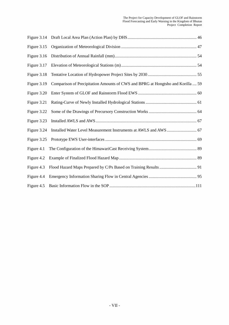
Figure 3.14 Draft Local Area Plan (Action Plan) by DHS ................................................................. 46
Figure 3.15 Organization of Meteorological Division ....................................................................... 47
Figure 3.16 Distribution of Annual Rainfall (mm) ............................................................................. 54
Figure 3.17 Elevation of Meteorological Stations (m) ....................................................................... 54
Figure 3.18 Tentative Location of Hydropower Project Sites by 2030 .............................................. 55
Figure 3.19 Comparison of Precipitation Amounts of CWS and BPRG at Hongtsho and Korilla .... 59
Figure 3.20 Enter System of GLOF and Rainstorm Flood EWS ....................................................... 60
Figure 3.21 Rating-Curve of Newly Installed Hydrological Stations ................................................ 61
Figure 3.22 Some of the Drawings of Precursory Construction Works ............................................. 64
Figure 3.23 Installed AWLS and AWS ............................................................................................... 67
Figure 3.24 Installed Water Level Measurement Instruments at AWLS and AWS ............................ 67
Figure 3.25 Prototype EWS User-interfaces ...................................................................................... 69
Figure 4.1 The Configuration of the HimawariCast Receiving System ............................................. 89
Figure 4.2 Example of Finalized Flood Hazard Map ......................................................................... 89
Figure 4.3 Flood Hazard Maps Prepared by C/Ps Based on Training Results ................................... 91
Figure 4.4 Emergency Information Sharing Flow in Central Agencies ............................................. 95
Figure 4.5 Basic Information Flow in the SOP ................................................................................. 111

The Project for Capacity Development of GLOF and Rainstorm Flood Forecasting and Early Warning in the Kingdom of Bhutan Project Completion Report
- VIII -
Abbreviations
AWLS Automatic Weather Level Station AWS Automatic Weather Station BICMA Bhutan InfoComm and Media Authority CBDRM Community Based Disaster Risk Management COS Central Operation System C/P Counterpart CR Control Room DCP Data Collection Platform DDM Department of Disaster Management DDMO Dzongkhag Disaster Management Office DGM Department of Geology and Mines DHMS Department of Hydro-met Services DHS Department of Human Settlement DoES Department of Engineering Service DoSE Department of School Education EUMETSAT European Organization for the Exploitation of Meteorological Satellites EOC Emergency Operation Center EWS Early Warning System FEMD Flood Engineering Management Division, DoES FHM Flood Hazard Map FMCR Flood Monitoring and Command Room FMI Finnish Meteorological Institute GIS Geographic Information System GNHC Gross National Happiness Commission GPV Grid Point Value GTS Global Telecommunication System GLOF Glacial Lake Outburst Flood ICT Information Communication Technology IMD India Meteorological Department IMTF Inter-Ministerial Task Force JCC Joint Coordination Committee JICA Japan International Cooperation Agency JMA Japan Meteorological Agency MDRR Mainstreaming Disaster Risk Reduction MHPA Mangdechhu Hydropower Authority MSS Message Switching System NDMA National Disaster Management Authority NLCS National Land Commission Secretariat NOAA National Oceanic and Atmospheric Administration NWFWC National Weather and Flood Warning Center NWP Numerical Weather Prediction OJT On the Job Training PC/R Project Completion Report PDM Project Design Matrix PO Plan of Operation SATAID Satellite Animation and Interactive Diagnosis SOP Standard Operating Procedure TMD Thai Meteorological Department UNDP United Nations Development Programme WB World Bank W/G Working Group WIS WMO Information System WMO World Meteorological Organization

The Project for Capacity Development of GLOF and Rainstorm Flood Forecasting and Early Warning in the Kingdom of Bhutan
Project Completion Report
- IX -

The Project for Capacity Development of GLOF and Rainstorm Flood Forecasting and Early Warning in the Kingdom of Bhutan Project Completion Report
- X -
The Project for Capacity Development of GLOF and Rainstorm Flood Forecasting and Early Warning in the Kingdom of Bhutan
Project Completion Report
- 1 -
Introduction Chapter 1
1.1 General
Bhutan is experiencing an increase in the number of disasters related to hydro-meteorological hazards. For instance, a record rainfall in May 2009 brought by Cyclone Aila left 12 people dead and damages to the infrastructure, which cost US$ 15.8 million. On the other hand, risk of glacial lake outburst flood (GLOF) increases because of global warming. Since the 1960s, a number of GLOFs have been recorded concurrently with the shrinkage of glaciers and expansion of glacial lakes over the region. The most recent GLOF occurred in October 1994 from the partial burst of the Luggye Tho in eastern Lunana. This flood caused loss of 21 lives and extensive damage to property along the Punakha - Wangdue valley. Therefore, continuous monitoring and installing an early warning system for rainstorm flood and GLOF were recommended by a previous study. Considering such situations, the Department of Hydro-met Service (DHMS), Ministry of Economic Affairs (MoEA), Royal Government of Bhutan tried to cope with such a situation. However, the capacity of monitoring and flood warning was limited. Thus, the Royal Government of Bhutan requested the Government of Japan for a technical cooperation project. As the result, “The Project for Capacity Development of GLOF and Rainstorm Flood Forecasting and Early Warning” was launched in September 2013.
The Project focuses on capacity development of central and local governments for weather and flood forecasting and early warning and emergency response against GLOF and rainstorm flood in the Mangdechhu and Chamkharchhu river basins. The Project also contributes to mainstreaming disaster risk reduction (MDRR) into development plans. As a result, a nationwide disaster resilient society against natural disasters such as GLOF and rainstorm flood for Climate Change Adaptation will be realized in Bhutan. The Project was implemented for three years from September 2013 to September 2016. This Project Completion Report compiles all the Project achievements for three years.
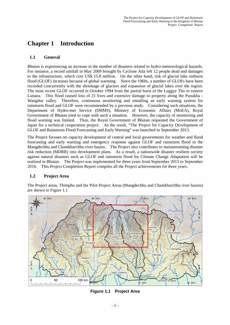
1.2 Project Area
The Project areas, Thimphu and the Pilot Project Areas (Mangdechhu and Chamkharchhu river basins) are shown in Figure 1.1
Figure 1.1 Project Area

The Project for Capacity Development of GLOF and Rainstorm Flood Forecasting and Early Warning in the Kingdom of Bhutan Project Completion Report
- 2 -
1.3 Target Beneficiary Population
The target number of beneficiary population for capacity development through the Project implementation is shown in Table 1.1
Table 1.1 Target Beneficiary Population for Capacity Development Agency Department Number Remarks
Direct Beneficiary
DHMS
Director 1
1) C/P for daily project activities 2) Supporting staff for the installation of Global Telecommunication System (GTS) and Early Warning System (EWS) and 3) Trainees for C/P trainings in Japan
Hydrology 12 Meteorology 11 Snow & Glacier 1
Planning, Coordination & Research
4
District office 4
Total 33 DDM 3 1) Participants of baseline survey
2) Members of flood hazard map and mainstreaming disaster risk reduction working groups and 3) Trainees for C/P trainings in Japan
DGM 1 DoES 7 NLCS 3 DHS 2 Total 16
Trongsa District
District 14 1) Seminar and/or workshop participants (district, county, target communities and schools) 2) Target people for evacuation based on EWS warning sirens 3) MHPA Staff related to EWS installation and 4) Trainees for C/P trainings in Japan
County 1 Community (& School) 51
Bumthang District
District 16 County 2 Community (& School) 2,094
MHPA MHPA 5 Total 2,183 Total 2,232
Indirect Beneficiary
Trongsa District 150 Bumthang District 2,800
MHPA MHPA 500 Contractor 6,000
Total 9,450

The Project for Capacity Development of GLOF and Rainstorm Flood Forecasting and Early Warning in the Kingdom of Bhutan
Project Completion Report
- 3 -
Methodology of Project Implementation Chapter 2
2.1 Project Purpose, Outputs and Activities
The Project was implemented based on the Project Design Matrix (PDM) and the Plan of Operation (PO) attached in the Record of Discussions agreed and signed on May 14, 2013 (refer to Appendix 2). The Project Purpose, Outputs and Activities described in the PDM are as follows:
Overall Goal: Nationwide disaster resilient society against natural disasters such as GLOF and rainstorm flood for Climate Change Adaptation is realized in Bhutan.
Project Purpose: Capacity of DHMS and relevant stakeholders on emergency response against GLOF/rainstorm flood is enhanced.
Output 1: Capacity of related agencies on GLOF/rainstorm flood risk assessment, development planning, disaster prevention, flood forecasting and warning as well as emergency information sharing among relevant agencies is enhanced.
Activities
1-1 Analyze the existing data accumulation and monitoring/alert system in DHMS /NWFFWC to develop feasible and sustainable integrated platform.
1-2 Set up necessary system and facilities for the integrated platform and train DHMS/NWFFWC staff to operate and maintain the system.
1-3 Review previous study including SATREPS on the potential risk of glacial lakes, and estimate the magnitude of GLOF as well as possible flood considering future climate change in corroboration with DGM and DoES.
1-4 Facilitate the discussion in enhancing coordination between GLOF/rainstorm flood risk assessment sector and development sector.
1-5 Prepare and improve GLOF/rainstorm flood risk zonation to be utilized for activity 3-2 through the training to NWFFWC, DGM, DoES, and NLCS staff.
1-6 Foster the sense of land use management among related agencies through workshops, etc.
1-7 Identify and propose institutions necessary for mainstreaming disaster risk assessment information into development plans.
1-8 Improve flood and weather forecasting system by use of accumulated hydro- meteorological data as well as numerical weather prediction data (GPV: Grid Point Value).
1-9 Develop SOP on emergency information sharing through discussion and workshops with relevant agencies.
Output 2: Early Warning System (EWS) for GLOF/rainstorm is developed and maintained in the pilot basins of Mangdechhu and the Chamkharchhu.
Activities
2-1 Review existing hydro-meteorological network and planned hydropower plants from the view point of administrative response on GLOF/rainstorm flood.
2-2 Analyze GLOF/rainstorm flood discharge, high-water level, flood arrival time and the other hydrological information to be applied for designing the EWS.
2-3 Design the location and specification of EWS composed of detection system, network, data management protocol and information sharing.

The Project for Capacity Development of GLOF and Rainstorm Flood Forecasting and Early Warning in the Kingdom of Bhutan Project Completion Report
- 4 -
2-4 Install equipment and facilities for the EWS in both pilot basins and NWFFWC with necessary provisions of spare parts and maintenance tools.
2-5 Prepare EWS operation and maintenance manual to train central and local DHMS staff on its testing, operation and maintenance.
Output 3: Emergency response capacity against GLOF/rainstorm flood at central and local level is enhanced in the pilot basins.
Activities:
3-1. Review flood emergency response on warning and evacuation in the pilot basins through workshops with participation of DDM, Local Government and Community residents.
3-2. List up the target communities and examine flood warning criteria in the pilot basins in the discussion with Local Government considering the findings derived from the activity 1-5, 2-2.
3-3. Plan and conduct warning and evacuation drills as well as EWS operation drill in the pilot basins.
3-4. Develop SOP for GLOF/rainstorm flood in the pilot basins through evaluation of activity 3-1 to 3-3.
2.2 Implementation Structure
The Project was implemented by the following structure as shown in Figure 2.1.
- Main counterpart agency: DHMS (Project Director: Director of DHMS, Project Manager: Chief of Hydrology Division, DHMS)
- Sub counterpart agency: Department of Disaster Management (DDM), Department of Geology and Mines (DGM), Department of Engineering Services (DoES), National Land Commission Secretariat (NLCS), Department of Human Settlement (DHS) and other relevant agencies
Figure 2.1 Project Implementation Structure

The Project for Capacity Development of GLOF and Rainstorm Flood Forecasting and Early Warning in the Kingdom of Bhutan
Project Completion Report
- 5 -
2.3 Implementation Schedule
Implementation phase and flow of the Project activities are shown in Figure 2.2. Detailed and specific project implementation schedule (plan and actual) prepared based on the PDM and PO is shown in Figure 2.3.
Figu
re 2
.2
Wor
k Fl
ow

The Project for Capacity Development of GLOF and Rainstorm Flood Forecasting and Early Warning in the Kingdom of Bhutan Project Completion Report
- 6 -
Figure 2.3 Project Implementation Schedule (Plan and Actual)
JCC ▼ ▼ ▼
▼ ▼ ▼
Seminor and W/S in Central ▼ ▼ ▼ ▼ ▼
▼ ▼ ▼ ▼ ▼
W/S in Local ▼ ▼ ▼ ▼
▼ ▼ ▼ ▼
Counterpart Training ▼ ▼
▼ ▼ ▼
Report ▼ IC/R ▼ PR/1 ▼ PR/2 F/R ▼
▼ IC/R ▼ PR/1 ▼ PR/2 F/R ▼
Output 1
[1-1]
[1-2]
a. Preparation of TOR to procure equipment for the integrated platform
b. Announcement, tendering, order, delivery and shipping
c. Settlement of the equipment into NWFFWC
d. Test operation and bug fixing of the system
e. Preparation of manuals for operation and maintenance of the integrated platform
f. Training based on the above manuals to NWFFWC staff
[1-3]
[1-4]
[1-5]
[1-6]
[1-7]
[1-8]
[1-9]
Output 2
[2-1]
[2-2]
[2-3]
[2-4]
a. Preparation of TOR to procure equipment for the integrated platform
b. Announcement, tendering, order, delivery and shipping for EWS
c. Construction of EWS facilities (AWS and AWLS)
d. Construction of EWS facilities (control station, siren tower, etc.)
e. Test operation and bug fixing of the EWS
[2-5]
Output 3
[3-1]
[3-2]
[3-3]
[3-4]
Work in Bhutan: As of Sep. 2013 (IC/R) As of Feb. 2016 (Final Evaluation)
2nd Phase2014 2015 2016
1st Phase9 10 12 1 2 3 4 911 12 5 65 6 7 8 9 1011 45 6 7 7 81 2 3 4 8 9 10 11 12 1 2 3
Awareness Raising in Relating Agencies on Land Use Management against Disaster
Explanation and Discussion of IC/R
Implementation of Baseline Survey
Capacity of DHMS and relevant stakeholders on emergency response against GLOF/rainstorm flood isenhanced.Analysis of Present State of NWFFWC on Existing Hydro-Met Data, Monitoring and Warning
Installation of Necessary Facilities to Develop Integrated Platform and Beginning Its Operation
Run-off and Flood Analyses based on Potential GLOF and Climate Change
Discussion to Enhance Coordination between GLOF/ Flood Risk Assessment and Development Sectors
Preparation and Improvement of Hazard Map through Training for Relevant Agencies
Proposal of Institution and Legal System for Mainstreaming Disaster Risk Assessment into Development
Improvement of Flood and Weather Forecasting System utilizing GPV
Development of SOP on Emergency Information Sharing through Discussion and Workshop
Early Warning System (EWS) for GLOF/rainstorm is developed and maintained in the pilot basins ofMangdechhu and the Chamkharchhu.Analysis of Current Conditionon Existing Meteorological and Hydrological Observation Network
Collecting and Analyzing Fundamental Information for Design of Early Warning System in Basins
Distribution Plan and Specification of EWS in Pilot Basins
Installation of Equipment and Facilities in Pilot Basins and NWFFWC
Preparation of Manual for EWS Operation and Maintenance and Training for DHMS Staff
Emergency response capacity against GLOF/rainstorm flood at central and local level is enhanced in thepilot basins.Holding Workshops to Review Flood Emergency Response on Warning and Evacuation in the Pilot Basins
List Target Communities and Examine Flood Warning Criteria in Pilot Basins
Plan Warning and Evacuation Drills as well as EWS Operation Drill in the Pilot Basins
Develop SOP for GLOF/Rainstorm Flood in Pilot Basins
The Project for Capacity Development of GLOF and Rainstorm Flood Forecasting and Early Warning in the Kingdom of Bhutan
Project Completion Report
- 7 -
2.4 Input
2.4.1 Japanese Side Input
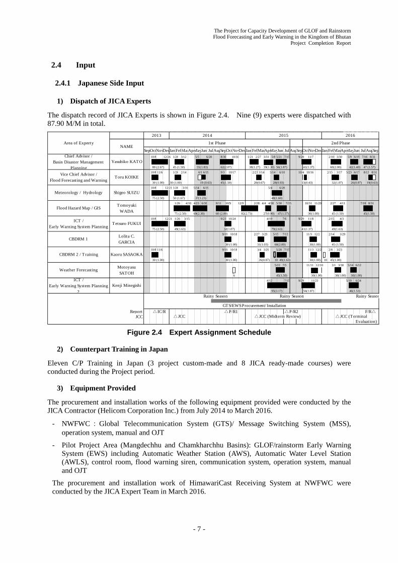
1) Dispatch of JICA Experts
The dispatch record of JICA Experts is shown in Figure 2.4. Nine (9) experts were dispatched with 87.90 M/M in total.
Figure 2.4 Expert Assignment Schedule
2) Counterpart Training in Japan
Eleven C/P Training in Japan (3 project custom-made and 8 JICA ready-made courses) were conducted during the Project period.
3) Equipment Provided
The procurement and installation works of the following equipment provided were conducted by the JICA Contractor (Helicom Corporation Inc.) from July 2014 to March 2016.
- NWFWC:Global Telecommunication System (GTS)/ Message Switching System (MSS), operation system, manual and OJT
- Pilot Project Area (Mangdechhu and Chamkharchhu Basins): GLOF/rainstorm Early Warning System (EWS) including Automatic Weather Station (AWS), Automatic Water Level Station (AWLS), control room, flood warning siren, communication system, operation system, manual and OJT
The procurement and installation work of HimawariCast Receiving System at NWFWC were conducted by the JICA Expert Team in March 2016.
Area of Experty
10/8 12/26 1/26 3/12 5/5 6/28 8/30 10/30 1/21 2/27 3/31 5/8 5/21 7/15 9/28 11/7 2/10 3/30 5/9 6/19 7/16 8/31
80 (2.67) 45 (1.50) 55(1.83) 62(2.07) 38(1.27) 39(1.30) 56(1.87) 41(1.37) 60(2.00) 42(1.40) 47 (1.57)10/8 11/6 1/26 2/14 6/1 6/19 9/3 10/17 2/23 3/14 5/14 6/10 10/4 10/16 2/15 3/17 5/23 6/17 8/13 8/31
30 (1.00) 30 (1.00) 19 (0.63) 45(1.50) 20(0.67) 28(0.93) 13(0.43) 32(1.07) 26(0.87) 19(0.63)10/8 12/21 1/26 3/16 5/14 6/19 5/4 6/20
75 (2.50) 50 (1.67) 37(1.23) 48(1.60)1/26 4/10 4/23 6/30 8/11 10/9 12/9 2/28 4/4 4/30 5/30 7/15 10/31 11/29 2/27 4/11 7/18 8/31
75 (2.50) 69(2.30) 60 (2.00) 82(2.73) 27(0.90) 47(1.57) 30(1.00) 45 (1.50) 45(1.50)10/8 12/21 1/26 3/15 9/23 10/24 4/19 7/6 9/29 11/8 2/15 4/3
75 (2.50) 49(1.63) 32(1.07) 79(2.63) 41(1.37) 49(1.63)9/19 10/18 2/27 3/29 5/15 7/13 11/3 12/2 2/14 3/29
30 (1.00) 31(1.03) 60(2.00) 30(1.00) 45 (1.50)10/8 11/6 9/19 10/18 3/4 3/29 5/28 7/15 11/3 12/2 2/8 3/23
30 (1.00) 30 (1.00) 26(0.87) 10 49(1.63) 30(1.00) 10 45(1.00)5/22 7/5 11/11 12/10 3/1 3/30 5/14 6/12
6 45(1.50) 30(1.00) 30(1.00) 30(1.00)4/12 7/15 9/29 11/23 5/10 6/24
95(3.17) 56(1.87) 46(1.53)
Rainy Season Rainy Season Rainy Season
Report △IC/R △P/R1 △P/R2 F/R△JCC △JCC △JCC (Midterm Review) △JCC (Terminal
Evaluation)
2014 2015 2016
NAME1st Phase
SepOctNov MayNovJan FebMarAprMayJun
Weather Forecasting MotoyasuSATOH
ICT /Early Warning System Planning
2Kenji Minegishi
2013
Dec
CBDRM 2 / Training Kaoru SASAOKA
Vice Chief Advisor /Flood Forecasting and Warning
Toru KOIKE
Meteorology / Hydrology Shigeo SUIZU
Flood Hazard Map / GIS TomoyukiWADA
JulAugSepOct DecJan FebMarApr MayJun JulAugSepOctNov
2nd Phase
ICT /Early Warning System Planning
Tetsuro FUKUI
CBDRM 1 Lolita C.GARCIA
Jun JulAugSepChief Advisor /
Basin Disaster ManagementPlanning
Yasuhiko KATO
DecJan FebMarApr
GTS/EWS Procurement/ Installation

The Project for Capacity Development of GLOF and Rainstorm Flood Forecasting and Early Warning in the Kingdom of Bhutan Project Completion Report
- 8 -
2.4.2 Bhutanese Side Input
1) Assignment of Counterpart Personnel
The main counterpart agency, DHMS and five sub-counterpart agencies, DDM, DGM, DoES, NLCS and DHS assigned appropriate counterpart personnel (C/P) to implement the Project activity with JICA Experts. The counterpart list is shown in Appendix 3.
What is notable is that DHMS dispatched a total of 16 staff to the Pilot Project Areas for around 6 months (May to June and September to October 2015, February to March 2016), at its own expense to assist the EWS installation work by JICA Contractor with the cooperation of the JICA Expert Team.
2) Provision of Working Space
DHMS provided several working spaces with Internet access in the DHMS office to JICA Experts aiming at effective collaboration with the C/Ps and transfer of technology on a daily one-to-one basis.
3) Budget Allocation
DHMS and sub-counterpart agencies secured and disbursed the following co-financing budget to implement the Project activities not covered by JICA.
- C/P personnel cost
- DHMS, DDM and DoES travel allowance to the Pilot Project Areas
4) Land Acquisition and Cutting Trees
DHMS completed the land acquisition (in coordination with district land acquisition committee and NLCS) and obtained the permission for cutting trees (in coordination with the Department of Forests and Park Services, MoAF) for the installation sites of EWS facilities (1 AWS, 3 AWLS and 7 flood warning sirens) before the commencement of the installation work.
The Project for Capacity Development of GLOF and Rainstorm Flood Forecasting and Early Warning in the Kingdom of Bhutan
Project Completion Report
- 9 -
The 1st Phase Achievements (Sep. 2013 - Jul. 2015) Chapter 3
This chapter compiles all the achievement of the Project activities in the 1st Phase (September 2013 – July 2015). The contents of this chapter is prepared by incorporating and re-editing the Progress Report 1 (September 2014) and Progress Report 2 (July 2015) of the Project.
3.1 Achievements Related to Entire Project
All the Project achievements related to entire project in the 1st Phase (September 2013 - July 2015) are described in this section.
3.1.1 Discussion with Bhutanese Side
1) Inception Report Meeting
(1) DHMS
The Project Inception Report meeting was held at DHMS on October 17, 2013 as the Project kick-off. The main counterpart agency DHMS, Sub-counterpart agencies DDM, DGM, DoES, NLCS and GNHC attended the meeting. It was agreed that DHS would participate in the Project as a Sub-counterpart agency to promote Mainstreaming Disaster Risk Reduction into the regional development plan. The meeting also discussed that the district governments in two pilot river basins be invited as Joint Coordinating Committee (JCC) members. The Minutes of the Meeting is as shown in Appendix 4. The meeting was widely covered on BBS, national TV and KUENSEL, the national newspaper.
(2) Trongsa District
An inception Report meeting was held at Trongsa District office on October 24, 2013. Around 20 participants attended the meeting such as deputy governor, district government staff from several sectors including disaster focal persons, the site manager of Mangdechhu Hydroelectric Project Authority (MHPA), county chief, community representatives and school principal.
It was agreed that the district official will join the Project as JCC member. DHMS requested the district government for support and assist for land allocation for setting up of EWS facilities and the district agreed with that.
(3) Bumthang District
An inception Report meeting was held at Bumthang District office on October 28, 2013. Around 20 participants attended the meeting such as school superintendents on behalf of deputy governor, district government staff from several sectors including disaster focal persons, Choekhor county chief, community representatives and school principal.
It was agreed that the district official will join the Project as JCC member. DHMS requested the district government for support

The Project for Capacity Development of GLOF and Rainstorm Flood Forecasting and Early Warning in the Kingdom of Bhutan Project Completion Report
- 10 -
and assist for land allocation for setting up of EWS facilities and the district agreed with that.
2) 1st Joint Coordinating Committee (JCC)
The 1st Project Joint Coordinating Committee (JCC) meeting was held at DHMS on February 7, 2014. The meeting was attended by officials from central government agencies in Thimphu and disaster focal persons from two districts. The Minutes of the Meeting is as shown in Appendix 5. The following are the main point discussed
- All the six counterpart agencies officially assigned appropriate counterpart personnel.
- All the participants agreed on the EWS system and its equipment/ facilities.
- Judging from the baseline survey results, it was agreed that the Project PDM was appropriate and it was not necessary to be revised at this stage.
- The project implementation schedule of each agency was agreed. (refer to Figure 2.3)
- Necessity of contact and follow up with BICMA on EWS communication frequency allocation
- Progress and status of land allocation formalities by DHMS for EWS facilities
3) Progress Report (1) Meeting
All the achievements and progress of the Project activities in the first half of the 1st Phase (September 2013 – September 2014) were compiled in the Progress Report (1) (P/R1) in September 2014. The P/R1 meeting was held at DHMS on July 16, 2014. The Minutes of the Meeting signed on September 30 is as shown in Appendix 6.
4) Progress Report (2) Meeting
All the achievements and progress of the Project activities in the second half of the 1st Phase (October 2014 – July 2015) were compiled in the Progress Report (2) (P/R2) in July 2015. The P/R2 meeting was held at DHMS on July 10, 2015. The Minutes of the Meeting signed on July 13 is as shown in Appendix 7.
3.1.2 Related Projects by Other Donors
1) UNDP
UNDP is supporting strengthening DHMS weather and hydrological networks (NAPA-II with USD 4 million). UNDP and the JICA Expert Team agreed to promote information sharing on both projects on October 11, 2013.
NAPA-I terminal evaluation mission visited the JICA Expert Team on December 12, 2013. The JICA Expert Team provided necessary Project information for information sharing.
After that, the JICA Expert Team conducted information sharing with UNDP periodically such as in the Mid-Team Review of the Project in February 2015.
2) World Bank
The JICA Expert Team discussed with the World Bank their proposed project for DHMS on October 20, 2013. The contents of the proposed project will be a socioeconomic study on Amochhu and Manas river basins in southern Bhutan and the project has no activity duplication with the JICA Project. The estimated project cost will be approximately USD 250,000.
The World Bank, DHMS, JICA Bhutan office and JICA Expert Team held a follow-up meeting on the proposed project on February 5, 2014. It was confirmed that the project formation status was almost the same as that in October 2013.

The Project for Capacity Development of GLOF and Rainstorm Flood Forecasting and Early Warning in the Kingdom of Bhutan
Project Completion Report
- 11 -
After that, the JICA Expert Team conducted information sharing with the World Bank periodically such as in the Mid-Team Review of the Project in February 2015.
3) Finnish Meteorological Institute
The Finish Meteorological Institute (FMI) is implementing the following project with Meteorological Division, DHMS. The project mainly deals with socio-economic aspects of weather forecasting and the major activity is short term counterpart training in Finland. FMI and the JICA Expert Team confirmed that there is no activity duplication between the two projects and agreed to exchange information on the progress of both projects.
- Name: Strengthening Hydro-Meteorological Services for Bhutan
- Period: May 2013 - May 2016
- Objective: To improve the capacity of DHMS to manage and produce high quality weather information and services
- Output: 1) Strategic planning capacity of DHMS strengthened, 2) Enhanced services provided by DHMS and 3) Improved DHMS cooperation and communication with the public, disaster management, media and renewable energy
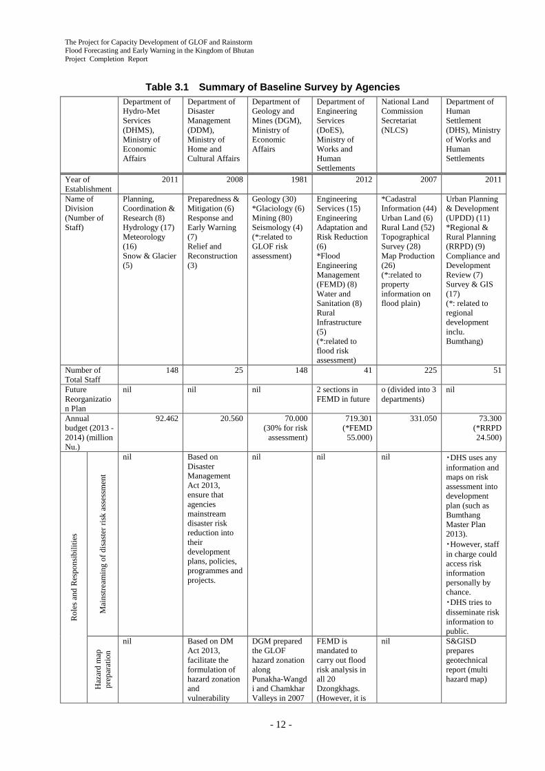
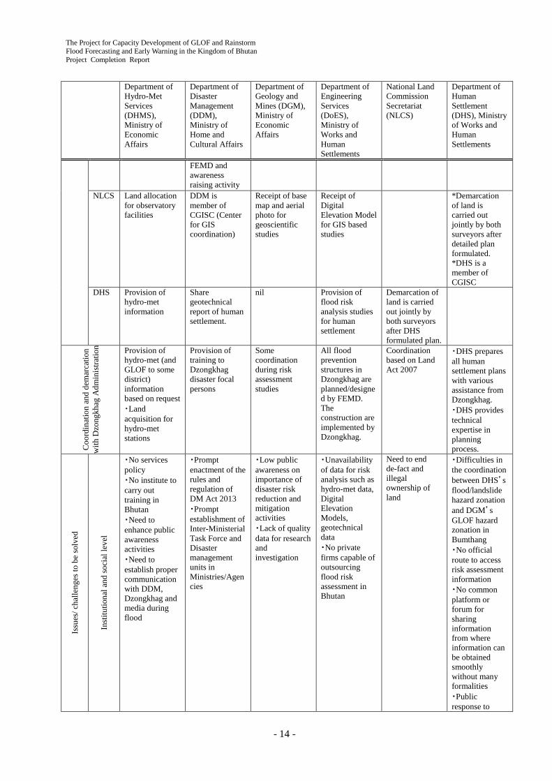
3.1.3 Baseline Survey
A baseline survey aiming at understanding basic status and issues on all the counterpart agencies was conducted with DHMS C/P in November and December 2013 based on the interview and questionnaire /surveys to DHMS, DDM, DGM, DoES, NLCS and DHS. The survey result was finalized through the discussion in the workshops of the Mainstreaming Disaster Risk Reduction working group described in Section 4.4.
As shown in the baseline survey results as of December 2013 in Table 3.1 and Table 3.2, many Project activities can work as “Catalyst” (or Trigger) to solve the Issues & challenges of each C/P agencies. Judging from the baseline survey results, it was judged that the Project PDM was appropriate and it was not necessary to revise it at this stage.
The Project for Capacity Development of GLOF and Rainstorm Flood Forecasting and Early Warning in the Kingdom of Bhutan Project Completion Report
- 12 -
Table 3.1 Summary of Baseline Survey by Agencies
Department of Hydro-Met Services (DHMS), Ministry of Economic Affairs
Department of Disaster Management (DDM), Ministry of Home and Cultural Affairs
Department of Geology and Mines (DGM), Ministry of Economic Affairs
Department of Engineering Services (DoES), Ministry of Works and Human Settlements
National Land Commission Secretariat (NLCS)
Department of Human Settlement (DHS), Ministry of Works and Human Settlements
Year of Establishment
2011 2008 1981 2012 2007 2011
Name of Division (Number of Staff)
Planning, Coordination & Research (8) Hydrology (17) Meteorology (16) Snow & Glacier (5)
Preparedness & Mitigation (6) Response and Early Warning (7) Relief and Reconstruction (3)
Geology (30) *Glaciology (6) Mining (80) Seismology (4) (*:related to GLOF risk assessment)
Engineering Services (15) Engineering Adaptation and Risk Reduction (6) *Flood Engineering Management (FEMD) (8) Water and Sanitation (8) Rural Infrastructure (5) (*:related to flood risk assessment)
*Cadastral Information (44) Urban Land (6) Rural Land (52) Topographical Survey (28) Map Production (26) (*:related to property information on flood plain)
Urban Planning & Development (UPDD) (11) *Regional & Rural Planning (RRPD) (9) Compliance and Development Review (7) Survey & GIS (17) (*: related to regional development inclu. Bumthang)
Number of Total Staff
148 25 148 41 225 51
Future Reorganization Plan
nil nil nil 2 sections in FEMD in future
o (divided into 3 departments)
nil
Annual budget (2013 - 2014) (million Nu.)
92.462 20.560 70.000 (30% for risk
assessment)
719.301 (*FEMD
55.000)
331.050 73.300 (*RRPD 24.500)
Rol
es a
nd R
espo
nsib
ilitie
s
Mai
nstre
amin
g of
dis
aste
r ris
k as
sess
men
t
nil Based on Disaster Management Act 2013, ensure that agencies mainstream disaster risk reduction into their development plans, policies, programmes and projects.
nil nil nil ・DHS uses any information and maps on risk assessment into development plan (such as Bumthang Master Plan 2013). ・However, staff in charge could access risk information personally by chance. ・DHS tries to disseminate risk information to public.
Haz
ard
map
pr
epar
atio
n
nil Based on DM Act 2013, facilitate the formulation of hazard zonation and vulnerability
DGM prepared the GLOF hazard zonation along Punakha-Wangdi and Chamkhar Valleys in 2007
FEMD is mandated to carry out flood risk analysis in all 20 Dzongkhags. (However, it is
nil S&GISD prepares geotechnical report (multi hazard map)

The Project for Capacity Development of GLOF and Rainstorm Flood Forecasting and Early Warning in the Kingdom of Bhutan
Project Completion Report
- 13 -
Department of Hydro-Met Services (DHMS), Ministry of Economic Affairs
Department of Disaster Management (DDM), Ministry of Home and Cultural Affairs
Department of Geology and Mines (DGM), Ministry of Economic Affairs
Department of Engineering Services (DoES), Ministry of Works and Human Settlements
National Land Commission Secretariat (NLCS)
Department of Human Settlement (DHS), Ministry of Works and Human Settlements
map by relevant agencies.
- 2008. (based not on hydrological/ hydraulic analysis.)
not clear which agency will prepare hazard maps.)
Info
rmat
ion
shar
ing
・GLOF: DDM and Dzongkhag, etc. based on SOP ・Flood: DDM and Dzongkhag ・Hydro-met data: relating agencies based on request, medias daily, hydropower project & India CWC hourly basis during summer
・DDM developed Disaster Management Information System (DMIS) as database and trained all Dzongkhag focal persons. ・DDM drafted Emergency Communication Network for functioning Emergency Operation Centre.
Reports and maps in DGM library are accessible to general public.
nil Share maps and information on need basis
DHS share geotechnical report with other agencies.
Coo
rdin
atio
n an
d de
mar
catio
n w
ith R
elev
ant A
genc
ies
(esp
ecia
lly o
n flo
od ri
sk)
DHMS
Receipt of weather forecasting & warning information during flood
Installation of GLOF EWS in Punakha-Wangdi Valley
Receipt of hydro-met information
Land allocation for observatory facilities
Receipt of hydro-met information
DDM Provision of weather forecasting & warning information during flood
Provision of technical expertise on flood (GLOF) hazard mapping and joint awareness campaign
All structural measures will be planned/ designed by FEMD, while all activities during disaster will be done by DDM.
nil Share geotechnical report of human settlement.
DGM Installation of GLOF EWS in Punakha-Wangdi Valley
In Punakha-Wangdi Valley, GLOF hazard mapping by DGM, EWS installation by DHMS and joint awareness campaign and flow of information system by DDM
Receipt of geological and geotechnical information in DGM archives
Provision of base map and aerial photo for geoscientific studies
nil
DoES Provision of hydro-met information
(Still UNDP concept stage) The flood risk assessment at Dagana and Zhemgang Dzongkhags by
Provision of geological and geotechnical information in DGM archives
nil Receipt of flood risk analysis studies for human settlement
The Project for Capacity Development of GLOF and Rainstorm Flood Forecasting and Early Warning in the Kingdom of Bhutan Project Completion Report
- 14 -
Department of Hydro-Met Services (DHMS), Ministry of Economic Affairs
Department of Disaster Management (DDM), Ministry of Home and Cultural Affairs
Department of Geology and Mines (DGM), Ministry of Economic Affairs
Department of Engineering Services (DoES), Ministry of Works and Human Settlements
National Land Commission Secretariat (NLCS)
Department of Human Settlement (DHS), Ministry of Works and Human Settlements
FEMD and awareness raising activity
NLCS Land allocation for observatory facilities
DDM is member of CGISC (Center for GIS coordination)
Receipt of base map and aerial photo for geoscientific studies
Receipt of Digital Elevation Model for GIS based studies
*Demarcation of land is carried out jointly by both surveyors after detailed plan formulated. *DHS is a member of CGISC
DHS Provision of hydro-met information
Share geotechnical report of human settlement.
nil Provision of flood risk analysis studies for human settlement
Demarcation of land is carried out jointly by both surveyors after DHS formulated plan.
Coo
rdin
atio
n an
d de
mar
catio
n w
ith D
zong
khag
Adm
inis
tratio
n Provision of hydro-met (and GLOF to some district) information based on request ・Land acquisition for hydro-met stations
Provision of training to Dzongkhag disaster focal persons
Some coordination during risk assessment studies
All flood prevention structures in Dzongkhag are planned/designed by FEMD. The construction are implemented by Dzongkhag.
Coordination based on Land Act 2007
・DHS prepares all human settlement plans with various assistance from Dzongkhag. ・DHS provides technical expertise in planning process.
Issu
es/ c
halle
nges
to b
e so
lved
Inst
itutio
nal a
nd so
cial
leve
l
・No services policy ・No institute to carry out training in Bhutan ・Need to enhance public awareness activities ・Need to establish proper communication with DDM, Dzongkhag and media during flood
・Prompt enactment of the rules and regulation of DM Act 2013 ・Prompt establishment of Inter-Ministerial Task Force and Disaster management units in Ministries/Agencies
・Low public awareness on importance of disaster risk reduction and mitigation activities ・Lack of quality data for research and investigation
・Unavailability of data for risk analysis such as hydro-met data, Digital Elevation Models, geotechnical data ・No private firms capable of outsourcing flood risk assessment in Bhutan
Need to end de-fact and illegal ownership of land
・Difficulties in the coordination between DHS’s flood/landslide hazard zonation and DGM’s GLOF hazard zonation in Bumthang ・No official route to access risk assessment information ・No common platform or forum for sharing information from where information can be obtained smoothly without many formalities ・Public response to

The Project for Capacity Development of GLOF and Rainstorm Flood Forecasting and Early Warning in the Kingdom of Bhutan
Project Completion Report
- 15 -
Department of Hydro-Met Services (DHMS), Ministry of Economic Affairs
Department of Disaster Management (DDM), Ministry of Home and Cultural Affairs
Department of Geology and Mines (DGM), Ministry of Economic Affairs
Department of Engineering Services (DoES), Ministry of Works and Human Settlements
National Land Commission Secretariat (NLCS)
Department of Human Settlement (DHS), Ministry of Works and Human Settlements
demarcation of disaster risk areas as no construction development is very poor.
Org
aniz
atio
n le
vel
・Develop reliable EWS system ・Placement not commensurate with cross sectoral responsibilities ・Ratio of hydro-met professional to technician is not appropriate
Insufficient technical and managerial capacity
・Limited human resources and financial capacity ・No or limited instrumentation ・Low priority in research activities
Need to recruit and train more professional staff as FEMD is at infancy stage
Requires further decentralization
A systematic checklist and a planning guide need to be prepared to assist planners
Pers
onal
leve
l
・Require more expertise in weather, climate and water resources field ・Limited technical capacity
No professional Dzongkhag disaster focal person assigned exclusively for disaster management
Limited interaction and exchange of ideas due to fewer numbers of national professionals involved in disaster risk assessment
nil Requires capacity building
Planners need to be trained and exposed to mainstreaming issue

The Project for Capacity Development of GLOF and Rainstorm Flood Forecasting and Early Warning in the Kingdom of Bhutan Project Completion Report
- 16 -
Table 3.2 Summary of Baseline Survey by Subjects Subject Institutional and Social
System Level Organizational Level Personal Level
1 Mainstreaming of Disaster Risk Reduction into Development
Issues/challenges to be solved
・Advocacy on DM Act 2013 to districts/sectors in order to create awareness on the requirement of mainstreaming DRR into their plans, policies and program has not been carried out. ・DM Rules and regulation is still in draft ・Organizational priority over DRR activities is not so high. ・Institutions to promote the mainstreaming such as Inter-Ministerial Task Force based on Disaster Management Act 2013 has not yet been established. ・As of today, there is no clear institutional mandates on disaster risk reduction; there seems to be some duplication
・So far, no specific policies and budget in related agencies for this purpose ・Limited coordination and systematic communication between agencies on this issue
Lack of awareness so far
Conceivable solutions
・Prompt adoption and enforcement of the rules and regulation of DM Act 2013 and educate the public on it.・Prompt establishment of the institutions based on DM Act 2013・As per DM Act 2013, DDM ensures and coordinates agencies to mainstream disaster risk reduction into their development plans, policies, programmes and projects.・Identify and propose institutions necessary for the mainstreaming (Activity 1-7)
・Discussion & formal communication between risk assessment sector and development sector to enhance coordination (Activity 1-4)・Workshops for awareness raising in related agencies on land use management against disaster (Activity 1-6)
Awareness raising on the mainstreaming through media, seminar, workshops, working groups etc. (Activity 1-4, 1-6 and 1-7)

The Project for Capacity Development of GLOF and Rainstorm Flood Forecasting and Early Warning in the Kingdom of Bhutan
Project Completion Report
- 17 -
Subject Institutional and Social System Level
Organizational Level Personal Level
2 Hazard Map Issues/challenges to be solved
・No clear-cut coordination mechanism among technical agencies for development of hazard maps・Inter-Ministerial Task Force to look into this kind of technical work is not formed yet. ・There is a strong need to identify specific agency to be able to prepare hazard map when other agencies required.・No official route to access risk assessment information・No common platform or forum for sharing risk and hazard information from where information can be obtained smoothly without lengthy formalities
DHMS: No professional staff in this field and no activity so far but provides required data to other agenciesDDM: Lacks GIS technical know-how skillsDGM: GLOF hazard zonation along Punakha-Wangdi and Chamkhar Valleys in 2007 - 2008 were not based on hydrological/ hydraulic analysis.DoES: FEMD is mandated to carry out flood risk analysis in all 20 Dzongkhags, however needs to recruit and train more professional staff as FEMD is in infant stage.DHS: DHS is not mandated to carry out hazard mapping. However DHS carried out multi-hazard mapping required to prepare master plan for urban area development by outsourcing because required hazard maps were not available with other government agencies.
Need more training on the preparation methodology to develop more professional staff in this field
Conceivable solutions
・DDM to facilitate coordination with relevant agencies on this issue to make the demarcation and mandates clear to avoid the duplication and miss match of hazard maps in the same area like in Bumthang.・Formation of Inter-Ministerial Task Force that can look into technical matters
・Update/prepare the maps by conducting hydrological/ hydraulic risk analysis for Mangdechhu and Chamkharchhu basins (Activity 1-3) (The case should be for all up-coming risk analysis)・Build capacity of DHMS and collaborating agencies in flood hazard mapping through trainings and counterparts apprenticeship. (Activity 1-5)
Provision of training on the map preparation process to the staff of related agencies (Activity 1-5)
3 Regional Disaster Management and Contingency Plan
Issues/challenges to be solved
・Establishment of the implementation structure of Dzongkhag Disaster Management Committee (DDMC) is still underway. ・Guideline for development of DM and Contingency plans is not finalized yet.
None of Dzongkhags have formulated the Plans so far.
・No professional Dzongkhag disaster focal persons assigned exclusively for disaster management ・High transfer rate of Dzongkhag focal person (DDM has to train newly assigned focal person from the beginning.)
Conceivable solutions
・Trained DM officials and other relevant officials on DM and contingency
・DDM will assist to formulate the Plan for Paro and Trongsa Dzongkhags.
Preparation of a Planning Guideline by DDM (to be finalized in July 2014) to

The Project for Capacity Development of GLOF and Rainstorm Flood Forecasting and Early Warning in the Kingdom of Bhutan Project Completion Report
- 18 -
Subject Institutional and Social System Level
Organizational Level Personal Level
planning guideline・DDM to facilitate and coordinate with Dzongkhags and formulate the plans to be implemented by the Dzongkhags
・Therefore, the flood risk assessment by JICA (Activity 1-3) and the hazard information collected through Joint CBDRM activity by DDM and JICA (Activity3-1~3) will be useful for the formulation in a timely fashion.
support Dzongkhag to formulate the Plan.
4 Flood Forecast and Warning System
Issues/challenges to be solved
・Social recognition of EWS and the policy priority in the Government is not high, since EWS is very new to Bhutan. ・Community's confidence in EWS seems not so high. ・Low awareness of community residents might cause the damage of equipment by stone-throwing or property loss. ・No institute to carry out training on EWS in Bhutan
・Only Punakha-Wangdi Valley has integrated EWS so far. ・New EWS installation project has a lot of budget, however, after the installation, the budget to maintain it is not enough .
・Need more training on EWS to develop more professional staff in this field ・Require more expertise in weather & climate field ・Gap between overseas training contents and everyday work
Conceivable solutions
Awareness raising activity through media, seminar and workshop for students (the Project Activity) and CBDRM (Activity 3-1~3)
Installation of new EWS to Mangdechhu and Chamkharchhu basin according to 11th 5-year Plan (Activity 1-2 and 2-1~4)
・Provision of practical training on EWS and its operation and maintenance to DHMS staff (Activity 1-2 and 2-5)・Provision of practical training on improvement of flood and weather forecasting system (Activity 1-8)
5 Information Sharing in Emergency
Issues/challenges to be solved
・National Emergency Operation Center (NEOC) and District Emergency Operation Centres (DEOC )that shall act as an information nerve center have not been established yet. ・Clear information sharing mechanism (SOP) is not put in place
DHMS's GLOF EWS in Punakha-Wangdue Valley is the only integrated system which has information sharing in emergency based on SOP so far. Other basins do not have any such a system.
No professional Dzongkhag disaster focal persons assigned exclusively for disaster management
Conceivable solutions
・Prompt establishment of NEOC and DEOC・Develop SOP on information sharing in emergency through discussion with relevant agencies (Activity 1-9)
New development of SOP in Mangdechhu and Chamkharchhu basins (Activity 3-4)
・Capacity development for Dzongkhag focal persons by continuous training by DDM・Recruitment and assignment of full time Dzongkhag disaster focal persons in several selected disaster prone Dzongkhag

The Project for Capacity Development of GLOF and Rainstorm Flood Forecasting and Early Warning in the Kingdom of Bhutan
Project Completion Report
- 19 -
3.1.4 1st Annual Seminar
The 1st Annual Seminar was held on June 19, 2015 aiming at sharing the Project progress and achievements with many stakeholders. Reflecting the high ownership of the Bhutanese side, most of the presentations were done by the C/P staff including the presentation by the DDM director. Around 60 participants, not only counterpart agencies, relevant agencies, district focal persons, donors, universities, media, NGOs but also VIP such as the Minister of Economic Affairs and several National Assembly members showed a high interest in the Project. The program and the participants list are shown in Appendix 8.
3.1.5 Counterpart Trainings in Japan
1) General
The Counterpart Trainings in Japan implemented seven times during the 1st Phase (September 2013 - July 2015) is as shown in Table 3.3.
Table 3.3 Record of C/P Training in Japan Type of training course
Name of training course Period Trainee
Duration (days) Date Number Organization
JICA ready-made
Capacity development for flood risk management with IFAS
28 Jul. 6- Aug. 2, 2014 3 DHMS 2 DoES 1
Reinforcement of meteorological services
90 Sep. 10 – Dec. 8, 2014
1 Met. Division, DHMS
Project custom-made
Utilization technology on meteorological satellite data (SATAID) (objective: To improve weather forecasting through the study on SATAID)
12 Oct. 29 - Nov. 8, 2014 3 Met. Division, DHMS
JICA ready-made
Comprehensive disaster risk management administration
48 Jan. 7 - Feb. 23, 2015 1 DDM
Strategy for resilient societies to natural disasters
55 Jan. 12 - Mar. 7, 2015 2 DDM DHS
Project custom-made
Technology on river management, EWS and weather observation (objective: To promote the Project activity through above study field)
12 May 10 – 21, 2015 6 DHMS:4 DGM:1 DoES:1
JICA ready-made
Capacity development for flood risk management with IFAS
28 July 6 – Aug. 2, 2015 1 Hydro. Division, DHMS

The Project for Capacity Development of GLOF and Rainstorm Flood Forecasting and Early Warning in the Kingdom of Bhutan Project Completion Report
- 20 -
As for the IFAS related training mentioned above, the trainees evaluated the training was useful, since the contents was not only to learn the usage of IFAS software but also to understand overall flood mitigation in Japan such as flood forecasting and early evacuation of residents.
As for the Project custom-made course in May 2015, the trainees learned various disaster management in Japan from national, province, municipality, university and civil society. The trainees were interested not only in flood management but also in overall natural disaster management especially after the big earthquake that happened in Nepal in April 25, 2015.
2) Debriefing Session on C/P Trainings in Japan
The 1st Debriefing Session on the C/P trainings in Japan was held on April 17, 2015 at DHMS. The trainees who participated in the courses from July 2014 to March 2015 as in the above Table 3.3 and made presentations to widely share the knowledge and experiences with 21 staff of relevant counterpart agencies. The program is as shown in Appendix 9.
It is confirmed through their presentations that all the trainees learned a lot of useful things on disaster management and were very active and positive to share the knowledge and experience with other people.
3.1.6 Project Mid-Term Review and the 2nd JCC Meeting
JICA Headquarters dispatched the Mid-Term Review Mission from January 26 to February 13, 2015 to review the Project activity and achievement. The JICA Expert Team cooperated with the interview survey to C/P and relevant focal persons and field survey conducted by the Mission.
The 2nd Project Joint Coordinating Committee (JCC) meeting was held at DHMS on February 13, 2015. The meeting was attended by officials from central government agencies in Thimphu and disaster focal persons from two districts. The Draft Mid-Term Review Report prepared jointly by Bhutanese and Japanese sides was discussed and agreed, and the Minutes of the Meetings was signed and exchanged. Among the five review criteria, the relevance, effectiveness, efficiency and impacts of the Project is considered to be high and the sustainability is considered to be relatively high.
3.2 Achievements on Output 1 Activities
All the Project achievements on Output 1 “Capacity of DHMS and relevant stakeholders on emergency response against GLOF/rainstorm flood is enhanced” in the 1st Phase (September 2013 - July 2015) are described in this section.
The following activities implemented in the 2nd Phase (October 2015 – September 2016) are excluded.
- Development of SOP on emergency information sharing through discussion and workshop with relevant agencies (Activity 1-9)

The Project for Capacity Development of GLOF and Rainstorm Flood Forecasting and Early Warning in the Kingdom of Bhutan
Project Completion Report
- 21 -
3.2.1 Present State of Existing Hydro-Met Data, Monitoring and Warning (Activity 1-1)
1) Evaluation of Meteorological and Hydrological Observation
(1) Hydrological Observation
i) Hydrological Observation Network
The hydrological observation network is shown in Figure 3.1. Primary and Secondary Stations were established to mainly provide hydrological information for water use sectors and gauge readers observe the water levels of rivers and conduct flow measurement at the stations. Flood Warning Stations were established to provide flood warning services and gauge readers observe the water levels at the stations. Real time AWLS have been installed to monitor the water level of rivers for flood warning.
A hydrological observation network covers all main rivers in Bhutan but it is recommended for the network to be expanded upstream for flood warnings to important cities in Bhutan.
Figure 3.1 Location of Hydrological Stations in Bhutan (as of January 2014)
ii) Primary, Secondary and Flood Warning Stations
Settings of the observation instruments, observation, maintenance and data processing of Primary and Secondary Stations were checked and evaluated. Some stations have several names and it causes confusion among data users. This matter will be resolved by using only one name for each station.
The observed data of Primary and Secondary hydrological stations are periodically reported to the Hydrology Division of DHMS and applied quality control is done manually. The daily data are stored in HYDATA, hydrological database and analysis software. HYDATA can develop rating curves and calculate discharges (river-flow) with the gauge height data and the rating curves. The data of Primary and Secondary hydrologic stations were published in the data book of “Surface Hydrological Data of Bhutan” in 2009 with the cooperation of a JICA senior volunteer. All observed and calculated data are stored in HYDATA. The rating curve is shifted or reproduced after the changes of river configuration and the daily hydrologic data are satisfactory. A discrepancy in the stations can be found in the list of the stations and the data. Some stations have several names and several values of their latitudes and longitudes. These discrepancies cause confusion among data
H_P: Primary Station H_S: Secondary Station FWS: Flood Warning Station AWLS: Real-time AWLS

The Project for Capacity Development of GLOF and Rainstorm Flood Forecasting and Early Warning in the Kingdom of Bhutan Project Completion Report
- 22 -
users. Similar discrepancies were found in the data of Flood Warning Stations. The following matters are recommended;
- To reproduce the site register book which defines unique name, station code, latitude, longitude and shows the position and elevation of reference datum of gauge height, the description of a site, the configuration of the rivers and their change, starting, stopping, resuming, the closing date of observation and their chronological information.
- To reproduce the list of observation sites based on the register book.
- To process all data by identified name and code shown in the reproduced list.
iii) Real Time AWLS
Setting of the observation instruments, observation, maintenance and data processing of real time AWLS were checked and evaluated. It is recommended that quality control be applied routinely on their data.
Real time AWLS were installed in order to provide timely warnings downstream since 2009. Flow measurements are conducted at few AWLS stations and the conversion of river stage to flow has not been made. Observed data are stored in databases but quality control has not been applied to the data. Missing, duplicates or doubtful data were found frequently in the raw data of real-time AWLS.
Real time AWLS will be the mainstream of the observation system. Their accurate data are very important and necessary for quantitative flood warning and the evaluation of water resources. The following are recommended to process the data of real time AWLS;
- Flow measurements will begin at high-priority stations
- Receiving data will be monitored routinely and duplicate data will be removed.
- In case the data cannot be retrieved through a communication system, the data will be downloaded from the data logger at the site.
- Wrong or doubtful data will be routinely monitored and the corrected data will be stored in a different database from the original data.
- All real time AWLS data will be monitored and stored in NWFWC after NWEFWC will be put in operation.
- It is preferable that a unified database will be created to process all AWLS data in NWFWC.
(2) Meteorological Observation
i) Meteorological Observation Network
Meteorological stations lie sparsely in mountainous areas and it is recommended to expand the meteorological station network, especially the rain gauge network in mountainous areas.
The meteorological observation network is shown in Figure 3.2. A lot of meteorological stations are located with one station in every 20 km square on average but the stations lie sparsely in mountainous areas. The distribution of annual average rainfall is shown in Figure 3.3. It shows a clear decreasing tendency towards the north, but also shows increasing tendency towards the far north. The figure cannot show clearly that a station at high elevation receives more rainfall in the stations along the same latitude. It is stated in chapter 3.3.1 that the rainfall at Bjizam or Chamkhar Station, the northernmost station in Mangdechhu or Chamkharchhu Basin, is less than the rainfall in the upper catchment area of each station. The present observation network provides inaccurate and underestimated rainfall in a basin. The rainfall observation in mountainous areas is very important and the installation of rainfall stations in mountainous area is recommended though their installation and maintenance is difficult.

The Project for Capacity Development of GLOF and Rainstorm Flood Forecasting and Early Warning in the Kingdom of Bhutan
Project Completion Report
- 23 -
Figure 3.2 Location of Meteorological Stations in Bhutan (as of January 2014)
Figure 3.3 Annual Rainfalls of Meteorological Stations
ii) Class A and Class C Stations
Settings of the observation instruments, observation, maintenance and data processing of Class A and Class C Stations were checked and evaluated. The meteorological data obtained by observers must be processed and stored in a database after the reproduction of an accurate station list.
The observed data of Class A and Class C stations are periodically reported to the Meteorology Division of DHMS and stored in Microsoft Excel. The data are not managed well and are mostly managed by individuals. Different individuals keep different lists of stations and their data. A unified list of the meteorological stations and their data are necessary. Inadequate numeric values are used to explain missing data and it confuses data users. The following are recommended;
- To collect all lists and data of observation kept in the Meteorology Division
- To reproduce the site register book which defines the unique name and station code and shows the latitude, longitude, elevation, region, observing parameters as well as the name of instruments, the site description, their change, starting, stopping, resuming, closing date of observation and chronological information.
M_A: Class A Station, M_C: Class C Station Following are Real-time Meteorological Stations; AWS: AWS, Ra: Rainfall, Ta: Air Temeperaute, RH: Relative Humidity

The Project for Capacity Development of GLOF and Rainstorm Flood Forecasting and Early Warning in the Kingdom of Bhutan Project Completion Report
- 24 -
- To produce the list of observation sites based on the register book.
- To process all data by identified name and code shown in the list of observation.
- To create a database and original data that will be stored in it. If missing data are shown in numeric value, a physically impossible data value, for example, –999 for rainfall, must be entered in the data field.
- To apply quality control on the original data and the corrected information will be stored in a different database from the original data.
- To use a physically impossible data value for the missing data
Self-recording instruments are installed at every Class A station and the recorded sheets are kept in each station. A part of the recorded charts have been read and the read data have been sent to the Meteorology Division. These charts can provide hourly rainfall and rainfall intensities and they are important for the construction of a weather forecast system and the evaluation of climate change. It is recommended to read hourly rainfall and rainfall intensity from the recorded charts and to store these data in the database.
iii) Real Time AWS
Settings of the observation instruments, observation, maintenance and data processing of real time AWS were checked and evaluated. The network of real time AWS is being expanded intensively, but their data are not well processed and it is recommended to apply quality control on their data.
Real time AWS are being intensively installed in recent years. Most of the real time AWS are operated by the Meteorology Division of DHMS, but their data are stored in a different database constructed by each different project. Some of the real time AWS are operated by the Hydrology Division of DHMS and their data are not shared with the Meteorology Division. Quality control is not applied to the data of real tile AWS and missing or duplicate or doubtful data were found frequently in the original data. Retrieval of the data from the data logger at the site has not been made for the missing data
The data of real time AWS will be essential for weather forecasting and their importance will increase. The following are recommended to process the data of real time AWS;
- Received data will be monitored routinely and duplicate data will be removed.
- In case the data cannot be retrieved through the communication system, the data will be downloaded from the data logger at the site.
- Wrong or doubtful data will be routinely monitored and the corrected data will be stored in a different database from the original data.
- All real time AWS data will be monitored and stored in NWFWC after NWFWC will be put in operation.
- It is preferable that a unified database will be created to process all AWS data in NWFWC.
2) Coordination with GTS/MSS Related Organizations
As a part of Output 1, DHMS and WMO member countries is connected via the GTS/MSS network. This system enable DHMS to access various meteorological information and enhance DHMS’s capability of meteorological analysis and forecasting. Figure 3.4 shows the GTS/MSS network in Asia. DHMS is present but not connected in the GTS. An implementation plan to connect GTS/MSS with DHMS was made. Thimphu and New Delhi is connected as the main circuit, Thimphu and Bangkok is connected as the backup circuit.

The Project for Capacity Development of GLOF and Rainstorm Flood Forecasting and Early Warning in the Kingdom of Bhutan
Project Completion Report
- 25 -
Figure 3.4 GTS/MSS Network in Asia
To install GTS/MSS, DHMS requires coordination with domestic and international organizations. The C/P of DHMS and Project experts are carrying forward the coordination. Table 3.4 shows the progress of the coordination in the 1st Phase of the Project.
Table 3.4 Progress Chart of Doing Action between DHMS and Related Organizations
Related
Organizations Contact Person
of DHMS Status Action Plan
1 WMO Mr. Singay
Dorji Met. Div.
Application Form of DHMS's observation stations was accepted by WMO. (Aug.2014)
DHMS will decide the observation stations and apply for WMO with these stations.
2
Indian Meteorological Department
Mr. Tayba Buddha Met. Div.
IMD approved to connect GTS between DHMS and IMD.
DHMS will provide information about the installation schedule of GTS, and will coordinate connection between DHMS and IMD.
3
Thai Meteorological Department
Mr. Tayba Buddha Met. Div.
Same actions as IMD are going on.
DHMS will provide information about the installation schedule of GTS, and will coordinate connection between DHMS and IMD.
4 Japan Meteorological Agency
Mr. Tayba Buddha Met. Div.
GTS Duty officer of JMA was introduced.

The Project for Capacity Development of GLOF and Rainstorm Flood Forecasting and Early Warning in the Kingdom of Bhutan Project Completion Report
- 26 -
Related
Organizations Contact Person
of DHMS Status Action Plan
5
EUMETSAT Mr. Tayba Buddha Met. Div.
DHMS asked questions about the DCP application form and received answers from EUMETSAT.
DHMS will send the application form of the DCPs and consult about the installation of the DCP system.
6
BICMA Mr. Kuenzang Hydr.Div.
BICMA generally agreed on the frequency allocation which DHMS requested.
After the DCP frequency is allocated by EUMETSAT, the DCP frequency will be requested by DHMS. HF frequency matters are under coordination between BICMA and the Royal Bhutan Army. After coordination, an official application form will be issued.
Coordination between DHMS and the Indian Meteorological Department (IMD) was advanced under cooperative support by DR. L.R.Meen. And coordination between DHMS and the Thai Meteorological Department (TMD) is taking place. DHMS also contacted the Bhutan Telecom/Internet Provider.
After the GTS/MSS is put in place, DHMS distribute observational meteorological data to the WMO member countries. Prior to the transmission of observational data, DHMS have to register the observation stations on the WMO record. DHMS do the registration procedure under the cooperative assistance of Mr. Mohan Abayasekara, An Observing Systems Division of WMO. Mr. Tsunoda of JMA was nominated as the contact person of the WMO Asian Region.
Observational data of AWS and AWLSs, which is installed on the rivers of Mangdechhu and Chamkharchhu, is transmitted to DHMS through the European Meteorological Satellite (METEOSAT) and GTS/MSS. DHMS is a user of the METEOSAT DCP system. To become a METEOSAT user, C/P and the JICA Expert Team continued to coordinate on the participation procedure.
As a part of Output 1, DHMS is connected with WMO member countries via the GTS/MSS network. This system enables DHMS to access various meteorological information and enhance DHMS’s capability of meteorological analysis and forecasting. The GTS system, which Bhutan becomes a member country, belongs to WMO Region Area II (RA II). The DHMS’s GTS is connected with India Meteorological Department (IMD) and with Thai Meteorological Department (TMD). DHMS is required to be registered on IMD and TMD, which are the Regional Telecommunication Hub of RA II. And also DHMS is required to be registered on the Department of Observation of RA II. The JICA expert assisted DHMS’s registration procedures to these organizations.
The DCP system, which is developed over Mangdechhu and the Chamkharchhu river basin for the EWS observation stations, employs EUMETSAT Data Relay system. The JICA expert assisted DHMS about the coordination with EUMETSAT, such as the registration of DHMS’s DCPs, the connection procedures and the test procedures.
The concrete progressions are described in the next section.
3.2.2 Installation and Operation of Equipment for Integrated System (Activity 1-2)
1) Draft the Technical Specification
The specifications of GTS/MSS related equipment and materials were drafted with careful attention to the following matters.

The Project for Capacity Development of GLOF and Rainstorm Flood Forecasting and Early Warning in the Kingdom of Bhutan
Project Completion Report
- 27 -
1) GTS/MSS is introduced to NWFWC in order to access various meteorological information which are produced by WMO member countries. This meteorological information is processed and displayed in a visual format.. This system is contribute to improve the ability of weather forecasters for the early warning of meteorological disasters.
2) Introduced GTS/MSS equipment and materials must meet the WMO Technical Standards.
3) The introduced DCP system should meet the EUMETSAT Technical Standards and WMO Technical Standards. Observational data of the Mangdechhu and Chamkharchhu rivers is transmitted to DHMS through the European Meteorological Satellite (METEOSAT) and GTS/MSS.
The specifications of GTS/MSS and EWS were drafted based on the baseline survey which was conducted in October 2013. On November 27, the draft specification was explained to C/P of DHMS and was generally agreed upon. Retouch and correction of specifications were made, based on the discussions with C/P about the registration procedure to WMO, the archive of observational data, etc. On December 16, the specification was accepted by DHMS.
On 7 February 2014, the specification was officially accepted at the First JCC meeting.
2) Discussion on Satellite Image Receiving Method
DHMS agreed to introduce satellite image receiving from the Japanese New Himawari through the Internet and direct image receiver instead of introducing the Chinese Feng Yun Series on May 8, 2014.
3) Preliminary Survey for Introduction of HimawariCast Receiving System
The HimawariCast Receiving System is introduced at DHMS during the 2nd Phase (October 2015 ~ September 2016).
The new Japanese Meteorological Satellite (Himawari-8) can acquire high resolution image data. Japan Meteorological Agency (JMA) converts this data and distributes to users via communication satellite. This distribution system is called HimawariCast. DHMS introduces the HimawariCast receiving system to utilize the high resolution satellite image. The information about the HimawariCast receiving system was collected from WMO and JMA.
Figure 3.5 shows the transition schedule of Himawari Operation which was provided by JMA.

The Project for Capacity Development of GLOF and Rainstorm Flood Forecasting and Early Warning in the Kingdom of Bhutan Project Completion Report
- 28 -
Figure 3.5 Transition Schedule of Himawari Operation
Since 24 April 2015, the JICA expert and the C/P investigated the installation place of HimawariCast Receiving System. After the installation of HimawariCast receiving system, the received high resolution image data contributes to utilize the SATAID program. The SATAID training for the DHMS’s members was conducted in Japan, Nov. 2014.
Figure 3.6 shows the configuration of the HimawariCast Receiving System.
Figure 3.6 Configuration of the HimawariCast Receiving System
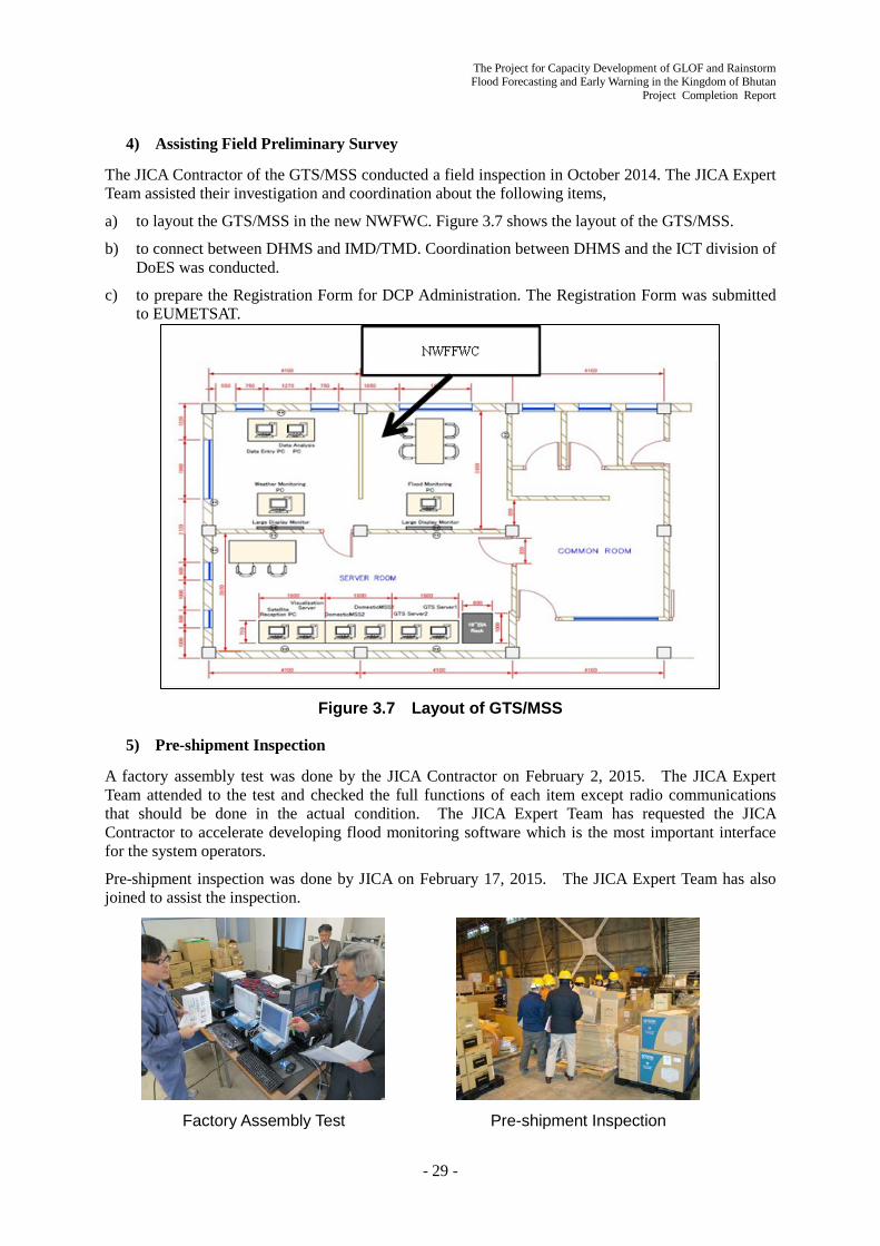
The Project for Capacity Development of GLOF and Rainstorm Flood Forecasting and Early Warning in the Kingdom of Bhutan
Project Completion Report
- 29 -
4) Assisting Field Preliminary Survey
The JICA Contractor of the GTS/MSS conducted a field inspection in October 2014. The JICA Expert Team assisted their investigation and coordination about the following items,
a) to layout the GTS/MSS in the new NWFWC. Figure 3.7 shows the layout of the GTS/MSS.
b) to connect between DHMS and IMD/TMD. Coordination between DHMS and the ICT division of DoES was conducted.
c) to prepare the Registration Form for DCP Administration. The Registration Form was submitted to EUMETSAT.
Figure 3.7 Layout of GTS/MSS
5) Pre-shipment Inspection
A factory assembly test was done by the JICA Contractor on February 2, 2015. The JICA Expert Team attended to the test and checked the full functions of each item except radio communications that should be done in the actual condition. The JICA Expert Team has requested the JICA Contractor to accelerate developing flood monitoring software which is the most important interface for the system operators.
Pre-shipment inspection was done by JICA on February 17, 2015. The JICA Expert Team has also joined to assist the inspection.
Factory Assembly Test Pre-shipment Inspection

The Project for Capacity Development of GLOF and Rainstorm Flood Forecasting and Early Warning in the Kingdom of Bhutan Project Completion Report
- 30 -
6) Assisting GTS/MSS Installation Work
During 22~28 April 2015, the JICA Expert Team assisted installation work of the GTS/MSS, that was conducted by the JICA contractor.
- 27 April 2015: The GTS/MSS circuit between DHMS and IMD was established. Also the DCP communication link between DHMS and EUMETSAT was verified.
- 8 June: EUMETSAT confirmed that all 5DCP stations data were received at Darmstadt.
- 10 June: The GTS circuit between DHMS and TMD was established.
- 3 July: All 5 EWS observation stations Data were confirmed by the GTS/MSS PC terminal at DHMS/ Thimphu. The communication route was, 5 observation stations => METEOSAT => Regional Telecommunication Hub in Germany => IMD => DHMS/ Thimphu
7) Preparation of GTS/MSS Operation and Maintenance Manual
To prepare the Operation and Maintenance Manual for the GTS/MSS, the role of WMO, relations between WMO and the GTS, the DHMS’s responsibilities for the GTS/MSS, the DHMS’s operational structure for the GTS/MSS were reviewed and discussed. The draft table of contents is as follows:
Contents of the draft Operation and Maintenance Manual (DRAFT) 1. Introduction
1.1 Background 1.2 Relation between the GTS and World Meteorological Organization 1.3 The GTS Communication Link 1.4 General responsibilities for the GTS Members
2. Functions and Responsibilities of the GTS 2.1 Meteorological Information System 2.2 Configuration of the DHMS’s Communication System
3. GTS Management 3.1 Meteorology Division 3.2 GTS/MSS Operation
4. Operation and Maintenance 4.1 Operation
4.1.1 Start of the GTS system 4.1.2 Monitoring the GTS system 4.1.3 Trouble Shooting
4.2 Maintenance 4.2.1 Annually, Monthly and Daily Check 4.2.2 Log Book 4.2.3 Maintenance Tool
5. Duties and Responsibilities of the GTS/MSS Operator 5.1 Duties and Assignment 5.2 Shift Duty
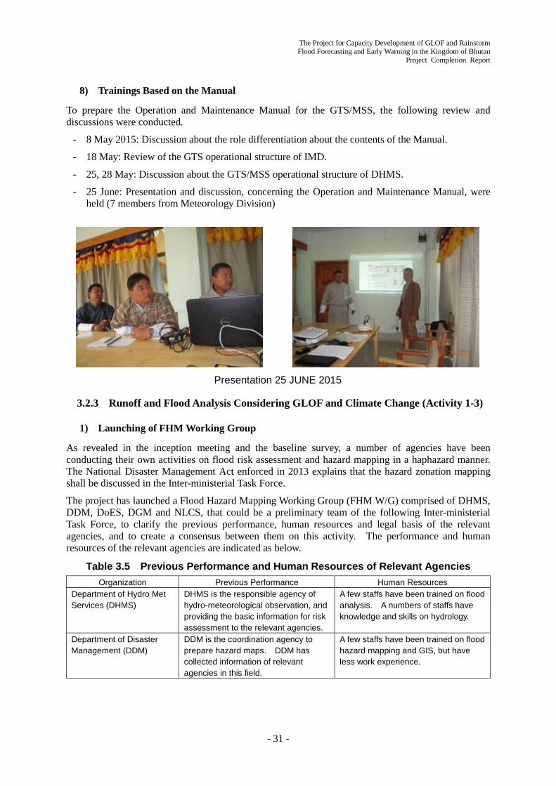
The Project for Capacity Development of GLOF and Rainstorm Flood Forecasting and Early Warning in the Kingdom of Bhutan
Project Completion Report
- 31 -
8) Trainings Based on the Manual
To prepare the Operation and Maintenance Manual for the GTS/MSS, the following review and discussions were conducted.
- 8 May 2015: Discussion about the role differentiation about the contents of the Manual.
- 18 May: Review of the GTS operational structure of IMD.
- 25, 28 May: Discussion about the GTS/MSS operational structure of DHMS.
- 25 June: Presentation and discussion, concerning the Operation and Maintenance Manual, were held (7 members from Meteorology Division)
Presentation 25 JUNE 2015
3.2.3 Runoff and Flood Analysis Considering GLOF and Climate Change (Activity 1-3)
1) Launching of FHM Working Group
As revealed in the inception meeting and the baseline survey, a number of agencies have been conducting their own activities on flood risk assessment and hazard mapping in a haphazard manner. The National Disaster Management Act enforced in 2013 explains that the hazard zonation mapping shall be discussed in the Inter-ministerial Task Force.
The project has launched a Flood Hazard Mapping Working Group (FHM W/G) comprised of DHMS, DDM, DoES, DGM and NLCS, that could be a preliminary team of the following Inter-ministerial Task Force, to clarify the previous performance, human resources and legal basis of the relevant agencies, and to create a consensus between them on this activity. The performance and human resources of the relevant agencies are indicated as below.
Table 3.5 Previous Performance and Human Resources of Relevant Agencies
Organization Previous Performance Human Resources Department of Hydro Met Services (DHMS)
DHMS is the responsible agency of hydro-meteorological observation, and providing the basic information for risk assessment to the relevant agencies.
A few staffs have been trained on flood analysis. A numbers of staffs have knowledge and skills on hydrology.
Department of Disaster Management (DDM)
DDM is the coordination agency to prepare hazard maps. DDM has collected information of relevant agencies in this field.
A few staffs have been trained on flood hazard mapping and GIS, but have less work experience.
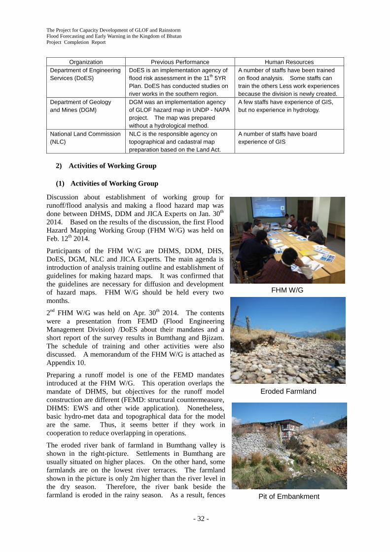
The Project for Capacity Development of GLOF and Rainstorm Flood Forecasting and Early Warning in the Kingdom of Bhutan Project Completion Report
- 32 -
FHM W/G
Eroded Farmland
Pit of Embankment
Organization Previous Performance Human Resources Department of Engineering Services (DoES)
DoES is an implementation agency of flood risk assessment in the 11th 5YR Plan. DoES has conducted studies on river works in the southern region.
A number of staffs have been trained on flood analysis. Some staffs can train the others Less work experiences because the division is newly created.
Department of Geology and Mines (DGM)
DGM was an implementation agency of GLOF hazard map in UNDP - NAPA project. The map was prepared without a hydrological method.
A few staffs have experience of GIS, but no experience in hydrology.
National Land Commission (NLC)
NLC is the responsible agency on topographical and cadastral map preparation based on the Land Act.
A number of staffs have board experience of GIS
2) Activities of Working Group
(1) Activities of Working Group
Discussion about establishment of working group for runoff/flood analysis and making a flood hazard map was done between DHMS, DDM and JICA Experts on Jan. 30th 2014. Based on the results of the discussion, the first Flood Hazard Mapping Working Group (FHM W/G) was held on Feb. 12th 2014.
Participants of the FHM W/G are DHMS, DDM, DHS, DoES, DGM, NLC and JICA Experts. The main agenda is introduction of analysis training outline and establishment of guidelines for making hazard maps. It was confirmed that the guidelines are necessary for diffusion and development of hazard maps. FHM W/G should be held every two months.
2nd FHM W/G was held on Apr. 30th 2014. The contents were a presentation from FEMD (Flood Engineering Management Division) /DoES about their mandates and a short report of the survey results in Bumthang and Bjizam. The schedule of training and other activities were also discussed. A memorandum of the FHM W/G is attached as Appendix 10.
Preparing a runoff model is one of the FEMD mandates introduced at the FHM W/G. This operation overlaps the mandate of DHMS, but objectives for the runoff model construction are different (FEMD: structural countermeasure, DHMS: EWS and other wide application). Nonetheless, basic hydro-met data and topographical data for the model are the same. Thus, it seems better if they work in cooperation to reduce overlapping in operations.
The eroded river bank of farmland in Bumthang valley is shown in the right-picture. Settlements in Bumthang are usually situated on higher places. On the other hand, some farmlands are on the lowest river terraces. The farmland shown in the picture is only 2m higher than the river level in the dry season. Therefore, the river bank beside the farmland is eroded in the rainy season. As a result, fences

The Project for Capacity Development of GLOF and Rainstorm Flood Forecasting and Early Warning in the Kingdom of Bhutan
Project Completion Report
- 33 -
GPS Training
HEC-RAS Training
fall down to the river bed. Countermeasures for the eroded farmlands are necessary from the view point of property protection. However, the priority of countermeasures to protect farmland is relatively lower than to save human life.
The pit of the embankment in Bumthang town is shown in the picture in the previous page. This pit may have been dug by local people for easy access to the river bank. This suggests that the local people have less realization of the risk of discontinuous embankment which has no resistance for river floods. The W/G members shared this information and confirmed the importance of an awareness program for disaster management such as CBDRM.
(2) Training
Training comprised of topographic surveys, runoff/flood analysis and GIS mapping were carried out for capacity development about flood hazard mapping. The schedule of the training and W/G is shown in Table 3.6.
Table 3.6 Schedule of Training and W/G of FHM (Feb.-Aug. 2014) Feb Mar Apr May Jun Jul Aug
Training (GPS, Analysis)
24th(DHMS,DDM),
26th(DHMS)
8th(DHMS) 20th(FEMD,
DHMS) 8th,9th(FEMD,DHMS) 23rd-27th
(all) Technical operation
support(DHMS,FEMD)
Survey at Pilot Site 24th-31st(DH
MS,FEMD) 18th-25th
(DHMS) 28th- 1st
(DHMS) W/G 12th 30th
i) GPS/GLONASS Basic Survey Training
Training on GPS/GLONASS survey was carried out on Feb. 14th 2014 in front of the DHMS building. Participants were from DHMS and DDM, members of FHM W/G. In addition, training in the Thimphuchhu river bank were held on Feb. 26th and Mar. 8th for DHMS and on Mar. 20th for FEMD/DoES. Objectives of the training were proficiency of the GPS handling and accuracy testing of the GPS equipment. The recorded GPS data were imported into GIS and utilized for a HEC-RAS flood analysis test with DHMS C/P.
The GPS handling techniques were explained for DHMS C/P in advance. The DHMS C/P mainly instructed them in the training for the other C/P along with handouts of GPS handling prepared by the JICA Expert. The DHMS C/P got to be able to use the GPS/GLONASS survey equipment by himself.
ii) Runoff/flood Analysis Training
As a preliminary study, flood analysis training requested by FEMD was held at FEMD office on Apr 8th and 9th. Participants were 2 persons from DHMS and 6 persons from FEMD. GPS and total station data obtained by the training in the Thimphuchhu river bank were utilized as demo-data. Contents of the training were data import to GIS, making a TIN model, data export to HEC-RAS and steady/unsteady analysis on HEC-RAS.
Figure 3.8 shows a result of the steady flow analysis by HEC-RAS. Difference between observed water level and simulated water level by using observed discharge as the boundary condition is ca. 10cm. The JICA Expert stressed the importance of simulated result validation to complete proper analysis. Figure 3.8 Example of HEC-RAS
Analysis in the Training

The Project for Capacity Development of GLOF and Rainstorm Flood Forecasting and Early Warning in the Kingdom of Bhutan Project Completion Report
- 34 -
Table 3.7 Schedule of Runoff/Flood Analysis Training
Data collection, data preparation, review of existing information, survey data import into GIS and preparing handouts for following runoff/flood analysis training were done with DHMS C/P in May and June. Training materials for HEC-RAS were prepared by DHMS C/P based on the experience of previous HEC-RAS training at the FEMD office in Apr. The DHMS C/P joined in the following training as lecturer assistant.
The runoff/flood training was held from Jun. 23rd to 27th 2014. Numbers of participants were 24 from all C/P agencies (DHMS:13、DDM:2、DGM:2、DoES:5、NLCS:1、DHS:1). The training aims understanding of basic procedure of the analysis, required data and output of the runoff/flood analysis through practical lessons.
Contents of the training (Table 3.7) were decided as practical because it was judged that C/P can get many chances to join in “lecture” type training.
Most of the participants had no or limited experiences on runoff/flood analysis, but the total number of the participants exceeded our expections.. High interest and expectation for runoff/flood analysis were reflected by a lot of participants of the training.
iii) Support for C/P’s Routine Works
In order to transfer techniques, the JICA Expert supported C/P’s routine works with GIS operation and/or runoff/flood analysis such as making maps of observation sites and calculating the basin boundary/area.
iv) Outcomes of 1st Phase Technique Transfer
The experiences of training participants about runoff/flood analysis were limited (Table 3.5), but currently DHMS and FEMD C/P have started to conduct GIS operation and flood analysis in other projects. It is judged that their understanding of analysis is improved because they could recognize data errors and problems on flow simulation by themselves.
3) Runoff/flood Analysis Model Preparation
Runoff/flood analysis models and hazard map preparation for EWS operation, CBDRM and land use regulation is being conducted, cooperating with C/P and JICA Experts. The current state of the activities are described in the following sections.
6/19 Thu,
20 Fri Installation of software in advance
6/23 Mon.
Opening remarks by Director, DHMS Remarks by JICA Experts General information about FHM Previous study about the flood hazard Runoff analysis by IFAS to simulate flood discharge
6/24 Tue.
Runoff analysis by IFAS to simulate flood discharge Making GIS base map for pilot sites Calculation of probable precipitation and discharge
6/25 Wed.
Flood analysis by iRIC to estimate flood area and depth
6/26 Thu.
Making terrain data (TIN and raster) by GIS Flood analysis by HEC-RAS to estimate flood area and depth
6/27 Fri.
Mapping the result of flood analysis by GIS Extract settlements and facilities built on high risk area
Runoff/flood analysis training
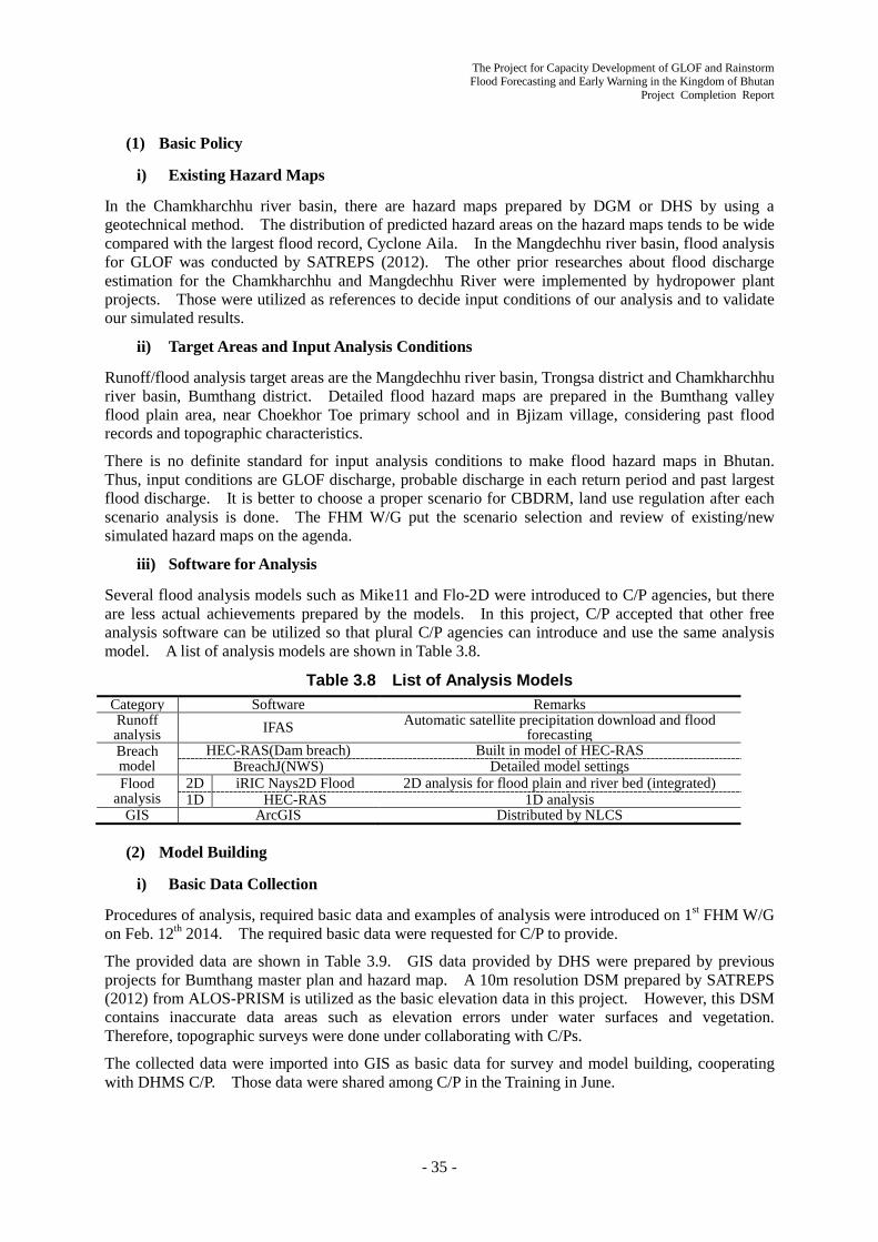
The Project for Capacity Development of GLOF and Rainstorm Flood Forecasting and Early Warning in the Kingdom of Bhutan
Project Completion Report
- 35 -
(1) Basic Policy
i) Existing Hazard Maps
In the Chamkharchhu river basin, there are hazard maps prepared by DGM or DHS by using a geotechnical method. The distribution of predicted hazard areas on the hazard maps tends to be wide compared with the largest flood record, Cyclone Aila. In the Mangdechhu river basin, flood analysis for GLOF was conducted by SATREPS (2012). The other prior researches about flood discharge estimation for the Chamkharchhu and Mangdechhu River were implemented by hydropower plant projects. Those were utilized as references to decide input conditions of our analysis and to validate our simulated results.
ii) Target Areas and Input Analysis Conditions
Runoff/flood analysis target areas are the Mangdechhu river basin, Trongsa district and Chamkharchhu river basin, Bumthang district. Detailed flood hazard maps are prepared in the Bumthang valley flood plain area, near Choekhor Toe primary school and in Bjizam village, considering past flood records and topographic characteristics.
There is no definite standard for input analysis conditions to make flood hazard maps in Bhutan. Thus, input conditions are GLOF discharge, probable discharge in each return period and past largest flood discharge. It is better to choose a proper scenario for CBDRM, land use regulation after each scenario analysis is done. The FHM W/G put the scenario selection and review of existing/new simulated hazard maps on the agenda.
iii) Software for Analysis
Several flood analysis models such as Mike11 and Flo-2D were introduced to C/P agencies, but there are less actual achievements prepared by the models. In this project, C/P accepted that other free analysis software can be utilized so that plural C/P agencies can introduce and use the same analysis model. A list of analysis models are shown in Table 3.8.
Table 3.8 List of Analysis Models Category Software Remarks Runoff analysis IFAS Automatic satellite precipitation download and flood
forecasting Breach model
HEC-RAS(Dam breach) Built in model of HEC-RAS BreachJ(NWS) Detailed model settings
Flood analysis
2D iRIC Nays2D Flood 2D analysis for flood plain and river bed (integrated) 1D HEC-RAS 1D analysis
GIS ArcGIS Distributed by NLCS
(2) Model Building
i) Basic Data Collection
Procedures of analysis, required basic data and examples of analysis were introduced on 1st FHM W/G on Feb. 12th 2014. The required basic data were requested for C/P to provide.
The provided data are shown in Table 3.9. GIS data provided by DHS were prepared by previous projects for Bumthang master plan and hazard map. A 10m resolution DSM prepared by SATREPS (2012) from ALOS-PRISM is utilized as the basic elevation data in this project. However, this DSM contains inaccurate data areas such as elevation errors under water surfaces and vegetation. Therefore, topographic surveys were done under collaborating with C/Ps.
The collected data were imported into GIS as basic data for survey and model building, cooperating with DHMS C/P. Those data were shared among C/P in the Training in June.

The Project for Capacity Development of GLOF and Rainstorm Flood Forecasting and Early Warning in the Kingdom of Bhutan Project Completion Report
- 36 -
Scene of survey (left) and embankment along the Bumthang Airport (right, height:ca.3m)
Table 3.9 Collected GIS Data Category Description Provider Hydrological data Discharge, Water Level (Time series and location) DHMS Meteorological data Precipitation, Temperature, …(Time series and station
location) DHMS Building Settlement, Hospital, Religious … (shape file) NLCS, DHS, NSB Infrastructure Road, Embankment, …(shape file) NLCS, DHS Topographic map Bumthang and Trongsa (shape file) NLCS Land cover Bumthang and Trongsa (shape file) NLCS Control point Bumthang and Trongsa (Excel, converted to shape file) NLCS Satellite image ALOS-AVNIR2
GeoEye (Bumthang) DGM(SATREPS) DHS
Elevation ALOS-PRISM DSM SATREPS
ii) Survey in the Target Basin
In advance of the survey in the target basin, exploration by JICA Experts was conducted for survey area confirmation and GPS equipment testing from Feb. 8th to 11th 2014. As a result, the interval of river cross-section survey of Japanese standard (ca. 200m) seems too short for Bhutan considering human resources. Thus, the interval of the cross-sections was decided as ca. 200m in important zones, like near villages and longer in other zones. C/P confirmed that on FHM W/G.
A test survey on Feb. 26th 2014 in Thimphuchhu river bank was conducted as C/P training and accuracy test of GPS equipment. Then, it appeared that GPS accuracy under unclear upward visibility was low. The JICA Expert discussed with C/P about this problem, and we decided to use both total stations owned by FEMD and GPS for the survey in the target basin. Training to import total stations and GPS was also carried out.
In order to collect hydro/topographic data for flood analysis, a cross-section survey was conducted from Mar. 24th to 31st 2014 in the target basin with DHMS and FEMD C/P. A second survey was conducted from May 18th to 25th to measure water level in the rainy season, new areas (Choekhor Toe primary school and small river in the Bumthang town) and error areas of the last survey. A third survey was conducted from Aug. 28th to Sep. 1st to collect the rainy season water level for model calibration.
The survey was mainly carried out along the embankment near the Bumthang Airport and properties to protect. The detected concerns were reported in 2nd FHM W/G. Obtained data were imported into GIS and utilized in the training.
iii) Runoff Analysis
Runoff simulation
Observed discharge at Kurjey gauging station on Chamkharchhu River, observed rainfall at Bumthang, satellite precipitation and simulated discharge by IFAS are shown in Figure 3.9. A similar analysis was done in the training in June. The simulated term is from May to Sep. 2009 including Cyclone Aila event. Reproducibility of the simulated discharge by using observed rainfall is higher than by

The Project for Capacity Development of GLOF and Rainstorm Flood Forecasting and Early Warning in the Kingdom of Bhutan
Project Completion Report
- 37 -
using satellite precipitation data sets. Both timing and magnitude of the simulated discharge by using satellite precipitation does not match observed. The runoff parameters were calibrated by C/P training in Japan.
Both observed rainfall and satellite precipitation are deficient considering water balance in the basin in summer (see section 3.3.1). Possible reasons are 1) observed rainfall can’t measure high rainfall in mountainous areas because there is no meteorological station in the high altitude area 2) no consideration for snow/glacier melt discharge in summer. As for reason 1), satellite precipitation data sets should reflect the increment of precipitation in the mountainous area, but the satellite data doesn’t represent the tendency in this case. As for reason 2), the snow/glacier melt amount was calculated by positive degree-day method and snow/glacier area detected from satellite image at the end of summer. The calculated snow/glacier melt amount was inputted to IFAS, but the melt discharge amount was not enough to fill the deficit. The deficit amount in the summer corresponds to ca. 50m3/s of base flow, which is relatively low compared with peak flow. Therefore, if the simulated discharge gains ca. 50m3/s in summer, it seems no problem in practical operation when DHMS forecasts flood discharge.
Probable rainfall/discharge
Table 3.10 shows probable rainfall and discharge calculated from observed data by using the Gumbel method, probable discharge calculated by using the
Bjizam Rainfall Discharge ( m3/s)
(mm/day) (mm/3days) observed IFAS 2009 Cyclone Aila
95.0 203.4 642 690
20 years 75.2 96.3 466 327 50 years 87.4 106.9 524 424 100 years 96.5 114.9 568 491 200 years 105.6 122.8 611 573 500 years 117.6 133.2 669 676 1000 years 126.6 141.1 712 753
Kurjey (Bumthang) Rainfall Discharge
(m3/s) (mm/day) (mm/3days) observed IFAS 2009 Cyclone Aila
90.0 138.5 586 612
20 years 64.8 120.1 309 298 50 years 75.6 141.6 339 365 100 years 83.7 157.8 361 423 200 years 91.8 173.9 384 475 500 years 102.5 195.1 413 545 1000 years 110.5 211.2 436 610
Table 3.10 Probable Rainfall and Discharge
※Rainfall/discharge in 2009 Cyclone Aila were excluded from calculation because those are plotted off Gumbel model
Figure 3.9 Simulated Discharge by IFAS (Kurjey) (upper: observed rainfall lower: satellite precipitation)

The Project for Capacity Development of GLOF and Rainstorm Flood Forecasting and Early Warning in the Kingdom of Bhutan Project Completion Report
- 38 -
probable rainfall and IFAS, and the past maximum discharge (Cyclone Aila, 2009) in the Chamkharchhu river basin (Kurjey, Bumthang) and Mangdechhu river basin (Bjizam). The parameters of the IFAS utilized on the analysis had been determined by C/Ps in the IFAS training in Japan
Mostly, calculated probable discharges by IFAS are larger than observed base probable discharges. This indicates that observed discharge, which records are kept only once a day, often miss peak discharge. Therefore, the probable discharges based on observed data may be of smaller value. The simulated probable discharge should be utilized to make flood hazard maps because of safety evaluation. This issue was discussed on the FHM W/G.
In addition, the calculated discharge will be converted to water level and applied to warning water level settings of EWS.
Flood Analysis Scenarios
According to the result of the runoff analysis, the observed and simulated past maximum discharge (Cyclone Aila, 2009) are greater than the 100 years probable discharge. Therefore, the past maximum discharge calculated by IFAS was decided to be utilized for flood analysis as a rainfall flood scenario. Details of the flood analysis are mentioned in section 3.2.5.
iv) Glacial Lake Outburst Simulation and Flood Analysis
Glacial Lake Outburst Simulation
There are many previous studies for GLOF in the target basins (e.g. SATREPS (2012)1, Fujita et al.(2013)2). In this project, target glacial lakes were selected from the lakes which have high possible flood volume (Chamkharchhu basin: Cham_gl_198, Mangdechhu basin: Mngd_gl_270), by reference to the previous studies. Glacial breach modelling was conducted by using the BREACHJ(NWS) model. Landsat images of the glacial lakes from 1970’s to the present were collected to evaluate the effects of climate change. As the result, the satellite images clarify that the areas of the target glacial lakes did not really increase. Thus, the recent lake areas were inputted to the breach model. Other parameters (e.g. moraine shape, grain size) were set by referring to ALOS DSM and the previous studies.
Flow Simulation and Flood Analysis
An HEC-RAS 1D unsteady flow analysis was conducted in the Mangdechhu basin (from the lake to hydropower plant) and the Chamkharchhu basin (from the lake to downstream of Bumthang floodplain). The upper boundary condition was set from the simulated hydrograph of GLOF at the mouth of the glacial lakes. GLOF discharge, flood traveling time and rough flood area at each point in the basin were calculated by the analysis. The simulated GLOF discharge at Bjizam and Kurjey are 2,039 m3/s and 3,254 m3/s, respectively. These simulated GLOF discharges are one order of magnitude larger than the past maximum rainfall discharge. The estimated flood traveling time is following.
- From Jongthang: To Bjizam (34min), Dam site (50min), Power plant (88min)
- From Tsampa: To Kagthang (27min), Choekhor Toe Primary School (34min), Kurjey (60min), Bumthang downtown (83min)
1 Final Report of SATREPS Project “Study of Glacial Lake Outburst Floods in the Bhutan Himalaya”, Graduate School of Environmental Studies, Nagoya University, June 2012 2 Fujita, K., Sakai, A., Takenaka, S., Nuimura, T., Surazakov, A.B., Sawagaki, T., and Yamanokuchi, T. (2013) Potential flood volume of Himalayan glacial lakes, Natural Hazards and Earth System Sciences, 13:1827–1839, doi:10.5194/nhess-13-1827-2013

The Project for Capacity Development of GLOF and Rainstorm Flood Forecasting and Early Warning in the Kingdom of Bhutan
Project Completion Report
- 39 -
Table 3.11 Total Number of Buildings in Simulated Flood Area
Location Type ~0.5m ~3.0m 3.1m~ Total ~0.5m ~3.0m 3.1m~ TotalResidence 0 0 0 0 3 1 0 4Education 0 0 0 0 0 0 0 0
Historical Place 0 0 0 0 0 0 0 0Health center/Hospital 0 0 0 0 0 0 0 0Commercial Building 0 0 0 0 0 0 0 0
Farm Building 0 0 0 0 0 0 0 0Official 0 0 0 0 0 0 0 0Total 0 0 0 0 3 1 0 4
Location Type ~0.5m ~3.0m 3.1m~ Total ~0.5m ~3.0m 3.1m~ TotalResidence 0 0 0 0 0 4 1 5Education 1 0 0 1 0 0 1 1
Historical Place 0 0 0 0 0 0 0 0Health center/Hospital 0 0 0 0 0 1 0 1Commercial Building 0 0 0 0 0 0 0 0
Farm Building 0 0 0 0 0 0 0 0Official 0 0 0 0 0 1 1 2Total 1 0 0 1 0 6 3 9
Location Type ~0.5m ~3.0m 3.1m~ Total ~0.5m ~3.0m 3.1m~ TotalResidence 0 0 0 0 0 0 0 0Education 0 0 0 0 0 0 0 0
Historical Place 0 0 0 0 0 0 0 0Health center/Hospital 0 0 0 0 0 0 0 0Commercial Building 0 0 0 0 0 1 0 1
Farm Building 0 0 0 0 0 0 0 0Official 2 0 0 2 0 3 1 4Total 2 0 0 2 0 4 1 5
Location Type ~0.5m ~3.0m 3.1m~ Total ~0.5m ~3.0m 3.1m~ TotalResidence 1 0 0 1 6 30 4 40Education 0 0 0 0 0 1 0 1
Historical Place 0 0 0 0 0 0 0 0Health center/Hospital 0 0 0 0 0 0 0 0Commercial Building 4 6 0 10 6 27 7 40
Farm Building 5 1 0 6 0 9 3 12Official 0 1 0 1 0 1 0 1Total 10 8 0 18 12 68 14 94
GLOF ScenarioPast Max. Scenario
Past Max. Scenario GLOF Scenario
Estimated flooding depth Estimated flooding depth
Kagthang
ChoekhorToe
Bumthang
Bjizam
These estimated flood traveling time and river elevation profile extracted from Digital Elevation Model will be utilized for EWS operation.
(3) Detailed Flood Analysis and Preparation of Flood Hazard Maps
Detailed flood analysis by using detailed terrain models was conducted in prone areas where settlements are located in/near the flood area simulated in the previous section. The target prone areas for detailed analysis were near Bumthang floodplain, Choekhor Toe Primary School, Kagthang and Bjizam. The analysis was done by iRIC Nays2D Flood or HEC-RAS steady flow analysis. The simulated flood areas were exported to FHM (refer to 3.2.5).
(4) Flood Damage Estimation
The Total number of flooded buildings in the prone areas estimated from the simulated flood areas and GIS building data are shown in Table 3.11. The estimated total number of flooded buildings in Bumthang is much higher than the other areas. The number of flooded buildings in GLOF scenario is five times higher than the past max rainfall flood scenario. Damages to buildings by GLOF are hence a concern.
The building data utilized in the flood damage estimation contains some errors and lack of data. Thus, the building data should be updated continuously.
3.2.4 Enhancement of Coordination between Risk Assessment Sector and Development Sector (Activity 1-4)
It was agreed that Project activities related to administrative issues such as Activity 1-4 (enhancing coordination between agencies), Activity 1-6 (land use improvement), Activity 1-7 (institutional strengthening) and Activity 1-9 (information sharing SOP) will be implemented by Mainstreaming Disaster Risk Reduction Working Group (MDRR W/G) organized by working level C/P from all the six counterpart agencies. The MDRR W/G will be held once every two to three months.
On February 26, 2014, the 1st MDRR W/G workshop was held at DHMS with the attendance of all the C/P agencies. The main topics discussed were the establishment of the W/G, outline of MDRR and DDM’s presentation on the status of Bhutanese MDRR and Disaster Management Act 2013 and baseline

The Project for Capacity Development of GLOF and Rainstorm Flood Forecasting and Early Warning in the Kingdom of Bhutan Project Completion Report
- 40 -
survey result. On June 6, 2014, the 3rd MDRR W/G workshop was held at DHMS with the attendance of all the C/P agencies except DGM. The baseline survey was reviewed, discussed and updated by all the participants. The Minutes of the Meetings are shown in Appendix 11.
3.2.5 Preparation and Improvement of Hazard Map through Training (Activity 1-5)
1) Finalization of Flood Hazard Maps
The draft flood hazard maps which were prepared in Oct. 2014 were revised through terrain data modification, parameter calibration and revision of the runoff scenario. Finalization of the flood hazard maps was completed in Feb. 2015 in collaboration with a DHMS officer who is in charge. The target area of the hazard maps are Bjizam village under Trongsa district in the Mangdechhu river basin and Bumthang valley, Choekhor Toe Primary School and surrounding areas under Bumthang district in the Chamkharchhu river basin. Subsequently, local peoples requested analysis area extension and detailed flood hazard maps for each community through CBDRM (Activity-3). Thus, the JICA Expert and the DHMS officer conducted additional analysis and prepared detailed maps for each community.
Figure 3.10 shows the flood hazard maps in Bumthang (GLOF scenario and past maximum rainfall scenario). As a result of the revision of analysis parameters based on flood area records, the simulated flood water levels become higher than the height of the embankment beside the airport, and the airport area is flooded in both scenarios. The simulated flooding depth at the upstream of the elevated national highway in the Bumthang town is relatively high. In addition, inundation above floor level by GLOF is estimated at the Gangrithang Primary School. Hence, early evacuation drill by CBDRM activity using the EWS installed by this project is expected to reduce injuries.
These hazard maps can be utilized as references for urban development plans and CBDRM activities. Therefore, the GIS data of the hazard maps were shared among the C/P agencies. Evacuation sites, routes and other information decided by CBDRM activities should be added and updated on the hazard maps as needed.
2) Activities of Flood Hazard Map Working Group
(1) Activities of FHM Working Group
The 3rd workshop of Flood Hazard Map Working Group (FHM W/G) was held on Oct. 7, 2014. A topic of the workshop was the draft hazard maps in the Mangdechhu and Chamkharchhu river basin (see Appendix 10). Participants were from DHMS(3)、DDM(1)、DoES(2)、DHS(1) and JICA Experts(3). Comparison between the draft hazard maps and existing hazard maps and necessity of presentation to directors of the relating agencies were the contents of the discussion. Especially, if there is large difference between the hazard maps prepared by this project and the existing hazard map utilized by DHS as a reference of Bumthang Valley Development Plan, severe impact is estimated on the resettlement plan and land use restriction. Thus, review of the two hazard maps is necessary after the project hazard map is finalized.
The 4th FHM W/G workshop was held on Feb. 24, 2015. The topic of the workshop was the finalized flood hazard maps in the pilot basins. Participants were from DHMS(6 including director), DDM(1), DGM(1), JICA Experts(3). A participant suggested that the standard for flooding depth classification in Japan (underfloor inundation:-0.5m, ground floor inundation:0.5m-2.0m or 3.0m, upstairs floor inundation: more than 2.0m or 3.0m) is applicable for Bhutan, and this comment was agreed to by the participants. The other comment was about disaster damage and cost estimation. In the future, the Bhutan Government should decide plans of flood countermeasures considering the cost-benefit balance estimated from the cost of flood countermeasures and the calculated amount of
The Project for Capacity Development of GLOF and Rainstorm Flood Forecasting and Early Warning in the Kingdom of Bhutan
Project Completion Report
- 41 -
Figu
re 3
.10
Haz
ard
Map
s in
Bum
than
g (le
ft:Pa
st m
axim
um ra
infa
ll sc
enar
io, r
ight:
GLO
F sc
enar
io)

The Project for Capacity Development of GLOF and Rainstorm Flood Forecasting and Early Warning in the Kingdom of Bhutan Project Completion Report
- 42 -
flood damage based on the flooding probabilities and the inundation areas estimated by this project. However, insufficient social wealth data is a big problem to estimate the cost and benefit balance. Outline of other discussions is described in Appendix 10.
(2) Comparison between Flood Hazard Map and Bumthang Valley Development Plan
The DHS officer who is in charge of urban development planning could not attend the 4th FHM W/G workshop. Thus, JICA Experts set another meeting with the DHS officer and discussed about the difference between the hazard area of this project’s hazard map and the DHS’s development plan based on the existing hazard map.
Most of the hazard area estimated by this project is in the restricted development area of DHS, but three significant differences were found (Figure 3.11). Among these areas, the locations where the DHS restricted development area is narrower than Project’s hazard area is set as non-residential areas such as stadium and storehouses near the airport. Therefore, it seems there is no serious problem. On the other hand, the area where planned restricted area is wider than Project’s hazard area is currently used as a residential area. The flooding risk in this area is relatively low since the area is located on the high river terrace. This issue was discussed in MDRR W/G workshop (refer to 3.2.6).
The airport has a plan to extend the runway to the north area which is a former river bed. This area has high flood risk because the area is still in the simulated GLOF/Rainstorm inundation area. It is necessary to improve safety against floods by river bed excavation and embankment strengthening when the government starts the runway extension.
3) Preparation of Flood Hazard Map Preparation Manual
Technical parts of the hazard map preparation manual were prepared and utilized in the training and OJTs of runoff and flood analysis. These materials are modified and revised as the flood hazard map preparation manual by FHM W/G.
Figure 3.12 Tentative Roles of Related Agencies on Flood Hazard Mapping
Figure 3.11 Restricted Development Area by DHS and GLOF Hazard Area by
the Project (green: DHS’s restricted area,
red&orange: project’s hazard area)
DHS’s restrict area > Project’s risk area
Project’s risk area > DHS’s restrict area
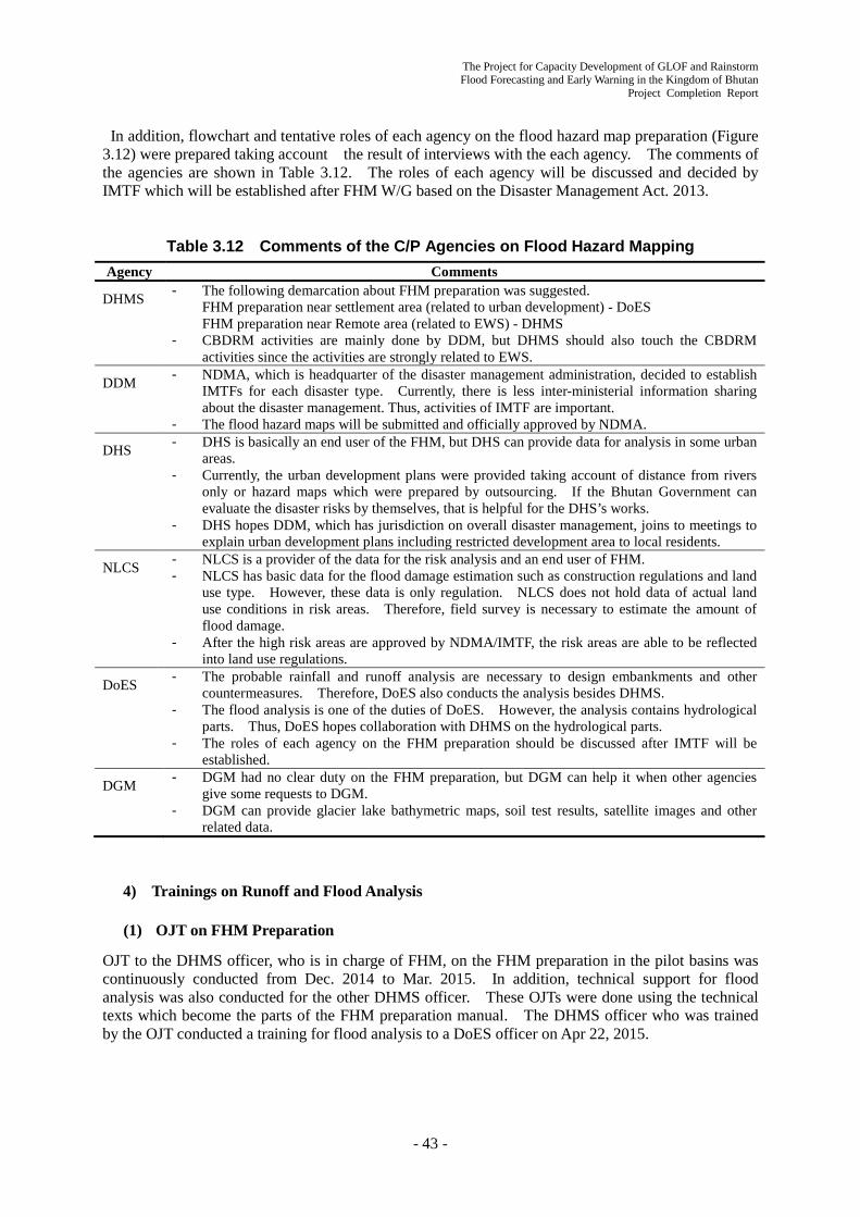
The Project for Capacity Development of GLOF and Rainstorm Flood Forecasting and Early Warning in the Kingdom of Bhutan
Project Completion Report
- 43 -
In addition, flowchart and tentative roles of each agency on the flood hazard map preparation (Figure 3.12) were prepared taking account the result of interviews with the each agency. The comments of the agencies are shown in Table 3.12. The roles of each agency will be discussed and decided by IMTF which will be established after FHM W/G based on the Disaster Management Act. 2013.
Table 3.12 Comments of the C/P Agencies on Flood Hazard Mapping Agency Comments
DHMS - The following demarcation about FHM preparation was suggested. FHM preparation near settlement area (related to urban development) - DoES FHM preparation near Remote area (related to EWS) - DHMS
- CBDRM activities are mainly done by DDM, but DHMS should also touch the CBDRM activities since the activities are strongly related to EWS.
DDM - NDMA, which is headquarter of the disaster management administration, decided to establish IMTFs for each disaster type. Currently, there is less inter-ministerial information sharing about the disaster management. Thus, activities of IMTF are important.
- The flood hazard maps will be submitted and officially approved by NDMA.
DHS - DHS is basically an end user of the FHM, but DHS can provide data for analysis in some urban areas.
- Currently, the urban development plans were provided taking account of distance from rivers only or hazard maps which were prepared by outsourcing. If the Bhutan Government can evaluate the disaster risks by themselves, that is helpful for the DHS’s works.
- DHS hopes DDM, which has jurisdiction on overall disaster management, joins to meetings to explain urban development plans including restricted development area to local residents.
NLCS - NLCS is a provider of the data for the risk analysis and an end user of FHM. - NLCS has basic data for the flood damage estimation such as construction regulations and land
use type. However, these data is only regulation. NLCS does not hold data of actual land use conditions in risk areas. Therefore, field survey is necessary to estimate the amount of flood damage.
- After the high risk areas are approved by NDMA/IMTF, the risk areas are able to be reflected into land use regulations.
DoES - The probable rainfall and runoff analysis are necessary to design embankments and other countermeasures. Therefore, DoES also conducts the analysis besides DHMS.
- The flood analysis is one of the duties of DoES. However, the analysis contains hydrological parts. Thus, DoES hopes collaboration with DHMS on the hydrological parts.
- The roles of each agency on the FHM preparation should be discussed after IMTF will be established.
DGM - DGM had no clear duty on the FHM preparation, but DGM can help it when other agencies give some requests to DGM.
- DGM can provide glacier lake bathymetric maps, soil test results, satellite images and other related data.
4) Trainings on Runoff and Flood Analysis
(1) OJT on FHM Preparation
OJT to the DHMS officer, who is in charge of FHM, on the FHM preparation in the pilot basins was continuously conducted from Dec. 2014 to Mar. 2015. In addition, technical support for flood analysis was also conducted for the other DHMS officer. These OJTs were done using the technical texts which become the parts of the FHM preparation manual. The DHMS officer who was trained by the OJT conducted a training for flood analysis to a DoES officer on Apr 22, 2015.
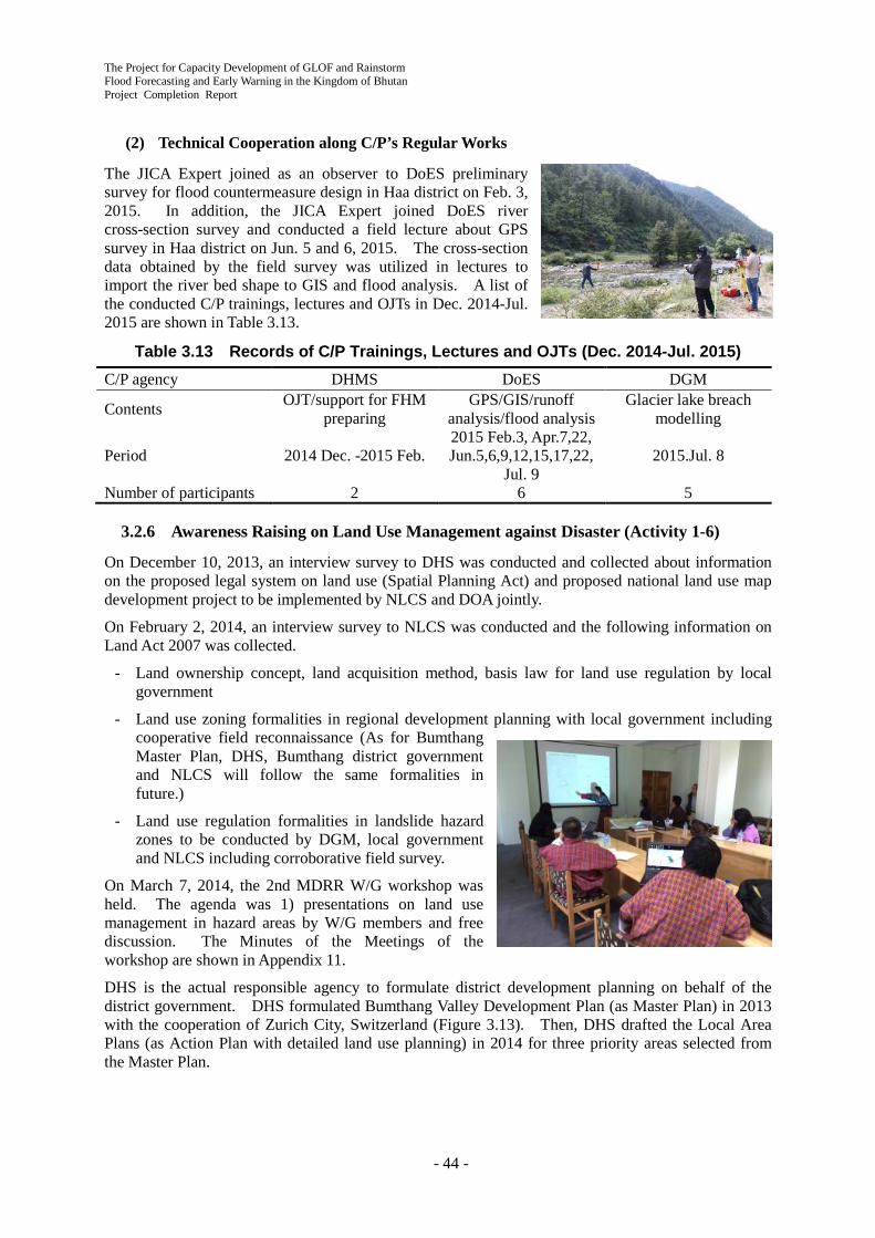
The Project for Capacity Development of GLOF and Rainstorm Flood Forecasting and Early Warning in the Kingdom of Bhutan Project Completion Report
- 44 -
(2) Technical Cooperation along C/P’s Regular Works
The JICA Expert joined as an observer to DoES preliminary survey for flood countermeasure design in Haa district on Feb. 3, 2015. In addition, the JICA Expert joined DoES river cross-section survey and conducted a field lecture about GPS survey in Haa district on Jun. 5 and 6, 2015. The cross-section data obtained by the field survey was utilized in lectures to import the river bed shape to GIS and flood analysis. A list of the conducted C/P trainings, lectures and OJTs in Dec. 2014-Jul. 2015 are shown in Table 3.13.
Table 3.13 Records of C/P Trainings, Lectures and OJTs (Dec. 2014-Jul. 2015) C/P agency DHMS DoES DGM
Contents OJT/support for FHM preparing
GPS/GIS/runoff analysis/flood analysis
Glacier lake breach modelling
Period 2014 Dec. -2015 Feb. 2015 Feb.3, Apr.7,22, Jun.5,6,9,12,15,17,22,
Jul. 9 2015.Jul. 8
Number of participants 2 6 5
3.2.6 Awareness Raising on Land Use Management against Disaster (Activity 1-6)
On December 10, 2013, an interview survey to DHS was conducted and collected about information on the proposed legal system on land use (Spatial Planning Act) and proposed national land use map development project to be implemented by NLCS and DOA jointly.
On February 2, 2014, an interview survey to NLCS was conducted and the following information on Land Act 2007 was collected.
- Land ownership concept, land acquisition method, basis law for land use regulation by local government
- Land use zoning formalities in regional development planning with local government including cooperative field reconnaissance (As for Bumthang Master Plan, DHS, Bumthang district government and NLCS will follow the same formalities in future.)
- Land use regulation formalities in landslide hazard zones to be conducted by DGM, local government and NLCS including corroborative field survey.
On March 7, 2014, the 2nd MDRR W/G workshop was held. The agenda was 1) presentations on land use management in hazard areas by W/G members and free discussion. The Minutes of the Meetings of the workshop are shown in Appendix 11.
DHS is the actual responsible agency to formulate district development planning on behalf of the district government. DHS formulated Bumthang Valley Development Plan (as Master Plan) in 2013 with the cooperation of Zurich City, Switzerland (Figure 3.13). Then, DHS drafted the Local Area Plans (as Action Plan with detailed land use planning) in 2014 for three priority areas selected from the Master Plan.

The Project for Capacity Development of GLOF and Rainstorm Flood Forecasting and Early Warning in the Kingdom of Bhutan
Project Completion Report
- 45 -
The 4th Workshop of Mainstreaming Disaster Risk Reduction Working Group (MDRR W/G) was held on April 10, 2015 with 14 participants from all the C/P agencies. The Minutes of the Meeting are shown in Appendix 11.
In the Workshop, based on the Draft Local Area Plan around Kurjey (Figure 3.14), the discussion on how to incorporate DHMS/JICA GLOF/flood hazard zonation and DGM GLOF hazard zonation into DHS Local Area Plan was held. In conclusion, with the attendance of the coordinating body, DDM, all the participants agreed DHS to take two hazard zonations into the Draft Plan. There was actually no change in the Draft Plan, since DHS flood hazard area prepared by a local consultant as a basis for the planning was safer (wider) side compared with DHMS/JICA and DGM zonation.
Figure 3.13 Bumthang Valley Development Plan (Master Plan) by DHS

The Project for Capacity Development of GLOF and Rainstorm Flood Forecasting and Early Warning in the Kingdom of Bhutan Project Completion Report
- 46 -
Figure 3.14 Draft Local Area Plan (Action Plan) by DHS
(Priority area around Kurjey)
3.2.7 Institution and Legal System for Mainstreaming Disaster Risk Reduction (Activity 1-7)
The present status and issues of relevant agencies for institutionalization of the relevant system and rules and regulations based on Disaster Management Act 2013 were investigated through the review of existing documents and discussion with DDM. The responsible agency of the development plan (DHS) and the planning system (DHS, district government, NLCS and the collaboration between risk assessment sectors and DDM) were studied through the above 4th MDRR W/G Workshop.
Following the Nepal large earthquake in April 25, 2015, the establishment of a national disaster management system, especially the institutionalization of Emergency Operation Centre (EOC) were highlighted as national priority issues according to the Disaster Management Act 2013. However, the issue to be solved is that DDM has no SOP and know-how in this field so far. Accordingly, the practical institution and legal system is proposed through the discussion in MDRR W/G Workshop in the 2nd Phase (September 2015 – September 2016).
3.2.8 Flood and Weather Forecast Utilizing the Numerical Weather Prediction (GPV) (Activity 1-8)
1) Current Status and Problems of the Weather Forecast in DHMS
In this project, a short term expert of weather forecasting is dispatched to improve the weather forecast system of DHMS. To prepare the terms of reference for the short term expert of weather forecasting, a basic survey about the DHMS service was conducted. The items of the survey were concerned with the organization, business in charge, operational procedures of weather forecasting, available meteorological information and archived meteorological data. There were several problems that had to be looked into.

The Project for Capacity Development of GLOF and Rainstorm Flood Forecasting and Early Warning in the Kingdom of Bhutan
Project Completion Report
- 47 -
To conduct operational forecasting, the meteorology division is mainly using 20 domestic observation stations data and other relevant meteorological information which are obtained via internet. DHMS doesn’t analyze its own weather charts, there is no archive of past data which is ready for operational use.
Based on the present condition of the Meteorology Division, terms of reference for the short term expert of weather forecasting were created.
1) Organization of the Meteorology Division
The Meteorology Division is composed of Meteorologists, Engineers, and Technicians. Many members are engaged at local observation stations. Figure 3.15 shows the organization of the Meteorology Division.
Meteorological Division is composed of following 36 members.
Meteorology Division: Chief 1 - Agromet/Climatology Section: 0 - Operation and Maintenance Section: Chief:1
・ Construction and Instrumentation Unit: 3 ・ Weather Forecasting Unit: 5
► Regional Meteorological Station: 20 ・ Data Processing Unit: 5
- Aviation Meteorology Section: 1
NWFWC consists of the members of Weather Forecasting Unit and the members of the Flood/GLOF Warning Unit.
Figure 3.15 Organization of Meteorological Division
2) Jurisdiction of Meteorology Division - Implementation of the meteorological plan, programs and policies of the department. - Provide daily weather forecast information to the public based on observation and study of various
models - Research and studies on long range forecasts, prepare seasonal forecasts (monsoon outlook)
annually for information to the public - Study/observation of extreme weather events like cyclone and heavy rainfall for press release and
timely information to the public. Analysis and research works on climatic data for specific purposes
- Planning of meteorological network and establishment of new stations
RegionalMeteorological
Station
Agromet/Climatology
Section
Operationand
Maintenance
MeteorologyDivision
AviationMeteorology
Section
WeatherForecasting
Unit
Construction &Instrumentation
Unit
DataProcessing
Unit

The Project for Capacity Development of GLOF and Rainstorm Flood Forecasting and Early Warning in the Kingdom of Bhutan Project Completion Report
- 48 -
- Establish and operate telecommunication network for the rapid exchange and dissemination of observed hydro-meteorological information
- Operation and maintenance of existing meteorological network (9 real time AWS, 20 Class A, 61 Class C stations) across the country
- Meteorological data collection, quality control, archiving and database management. Provide climatic data and services to the Government for planning of developmental activities including private sector for specific studies and projects
- Data processing in coordination with PCRD for archive in a central database for statistical analysis, dissemination and publication
- Collect and provide aviation forecasts services in the future
3) Current status of operational weather forecast
More than 70 percent of the Bhutanese population are farmers and are faced with lots of challenges due to limited access of information on climate change. The Meteorology Division has started basic weather forecasting for the entire country (20 districts) only from October 2007. The present forecast is basically the weather outlook and the maximum/minimum temperature for 24 hours.
a. Routine operation of weather forecasting
Routine operation of weather forecasting is conducted by 1 shift forecast team (2 members). Operation time for weather forecasting seems 3-4hours. Because of the shortage of latest meteorological data and of inadequately archived data, it is difficult to realise a correct/timely weather forecast.
- Operation procedure of weather forecasting
During the morning: Access Web Sites, such as IMD, TMD, MetGIS, and so on. Forecasters get observational data, analysed weather chart, satellite image, numerical weather prediction, etc.
During the afternoon: Observational data are collected from 20 manned observation stations. Using these data and the collected Web site information, forecasters consider the daily weather forecast for the entire country (20 districts) and provide the forecast to the public.
b. Weather analysis and available information - DHMS does not draw up its own Weather Charts. Weather analysis is conducted by using internet
accessed weather charts such as analysed by IMD, TMD, and Bangladesh Meteorological Department (BMD).
- Indian Meteorological Satellite Images are accessed via Internet. - Bhutan is in a high mountain area, but upper air analysis is not carried out. - The prediction of minimum and maximum temperatures are conducted by using the Mori Model,
this prediction is based on the accumulated 17 year data, temperature data report from 20 observation stations and meteogram information from India.
- Archived data, such as rainfall data and/or weather charts, are not used during routine forecasting operation.
- The Weather Research and Forecasting Model of NOAA is not in use, because it is difficult to get near real time data via the Internet.
c. Data Management - Observed meteorological data are not systematically archived and also the quality control of data
is not so good. - The Operation and Maintenance Section has many tasks, which are related to make up the plan of
a new observation network and installation works (including observation system supported by international donors). This Section visits and maintains the existing 9 real time AWSs, 20 Class A stations and 61 Class C stations. But some of the observation stations are not operated because of lack of spare parts.

The Project for Capacity Development of GLOF and Rainstorm Flood Forecasting and Early Warning in the Kingdom of Bhutan
Project Completion Report
- 49 -
4) Past records of Training for Capacity Development
Training for capacity development has been carried out as follows. Almost all of the training, except JICA’s Meteorological training, were conducted for few days or less than two weeks. - Reinforce of Meteorological Service (JICA) - Numerical Weather Prediction (WMO/China) - Hydro-Meteorology and GIS (WMO) - Satellite Meteorology and Weather Forecast (Philippines) - Producing High Resolution Climate Information (WMO/Korea) - Meteorological Instrument and Calibration (Philippines) - International Workshop on Climate data (WMO/China)
5) Implementation Plan for Weather Forecast of Meteorological Division
Operational weather forecast of Meteorological Division involves basic problems, such as the lack of Meteorological Information for analysis and the imperfect quality control of observational meteorological data.
In this Project, GTS/MSS and Satellite Data Receiving Equipment are introduced at NWFWC. This equipment and facilities contribute to get various meteorological information such as GPV data, hydro-Meteorological data and Satellite Image data. A Meteorological expert is dispatched to utilise this information. The TOR of the Meteorological expert was planned shown as follows.
- Developing systematic weather forecasting operation and conducting training based on the
training materials
Training materials are made using the GPV data of GTS/MSS output. The JICA Expert conducts training using these materials. The JICA Expert reviews the new routine operation procedure to improve weather forecasting, weather advisory/warning and flood forecast. He also reviews data archiving system. - Make up the Operation Manual of Weather Forecasting
The Operation Manual of Weather Forecasting is made in parallel with the above mentioned reviews of forecasting operation. This manual includes the assessment of the following items, such as archived data, procedure of forecasting, and standards of advisory/warning.
2) Preparation for the Training of SATAID
In this Project Japanese Meteorological Satellite data Receiving system and software named SATAID are installed. The SATAID is application software to display satellite imagery and Numerical Weather Prediction for weather analysis. To make effective use of this system, training for utilization technology of meteorological Satellite imagery is conducted in Japan and Bhutan. In November 2014, JICA conducted “the training for utilization technology on meteorological Satellite” in Japan.
3) Trainings for SATAID Utilization Technology in Japan and Bhutan
The training on the utilization technology of meteorological Satellite imagery SATAID for three forecasters in Meteorology Division of DHMS was implemented in Japan from 30 October to 7 November 2014.
The JICA Expert implemented the presentation for the purpose both of introduction of SATAID and necessary conditions for improvement of weather forecast utilizing SATAID, and of review of JICA training course for utilization of SATAID, for ten
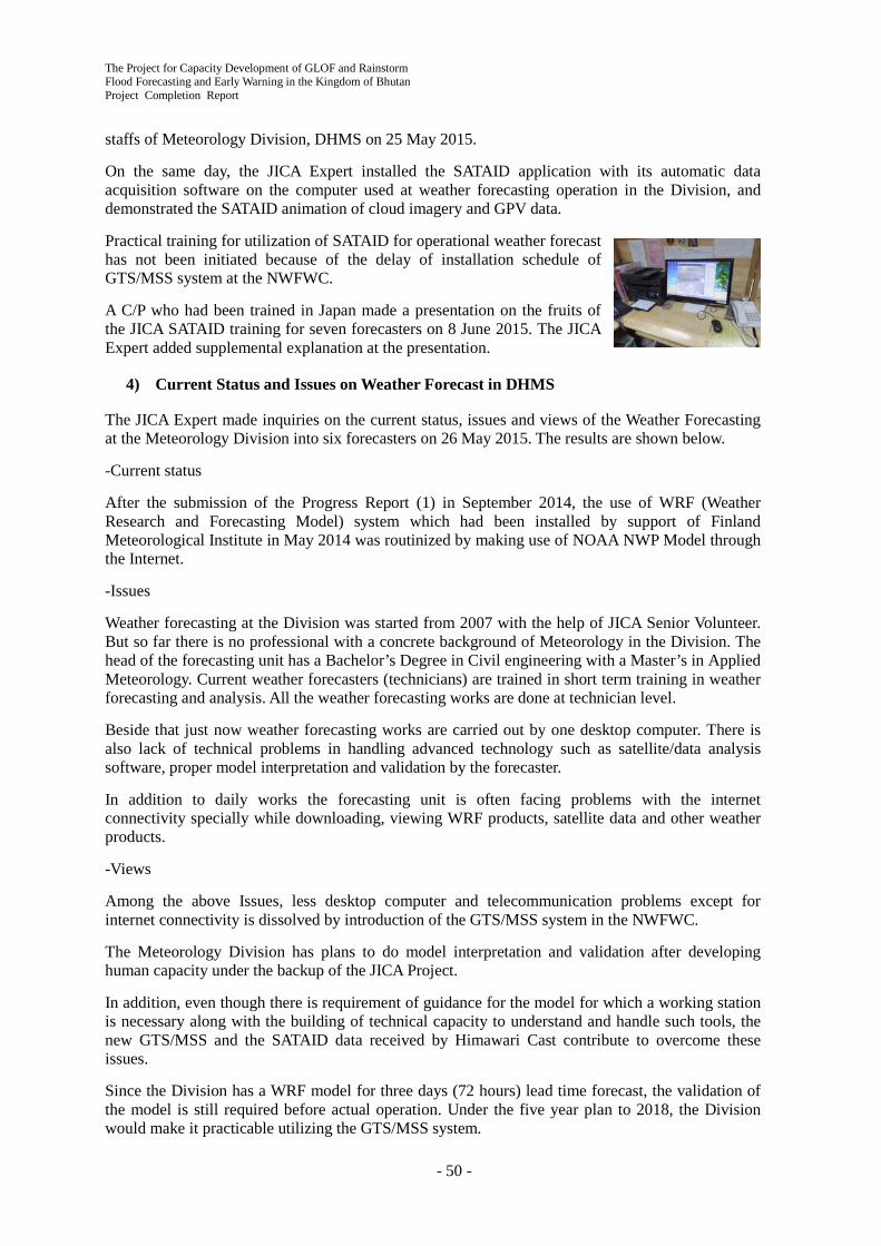
The Project for Capacity Development of GLOF and Rainstorm Flood Forecasting and Early Warning in the Kingdom of Bhutan Project Completion Report
- 50 -
staffs of Meteorology Division, DHMS on 25 May 2015.
On the same day, the JICA Expert installed the SATAID application with its automatic data acquisition software on the computer used at weather forecasting operation in the Division, and demonstrated the SATAID animation of cloud imagery and GPV data.
Practical training for utilization of SATAID for operational weather forecast has not been initiated because of the delay of installation schedule of GTS/MSS system at the NWFWC.
A C/P who had been trained in Japan made a presentation on the fruits of the JICA SATAID training for seven forecasters on 8 June 2015. The JICA Expert added supplemental explanation at the presentation.
4) Current Status and Issues on Weather Forecast in DHMS
The JICA Expert made inquiries on the current status, issues and views of the Weather Forecasting at the Meteorology Division into six forecasters on 26 May 2015. The results are shown below.
-Current status
After the submission of the Progress Report (1) in September 2014, the use of WRF (Weather Research and Forecasting Model) system which had been installed by support of Finland Meteorological Institute in May 2014 was routinized by making use of NOAA NWP Model through the Internet.
-Issues
Weather forecasting at the Division was started from 2007 with the help of JICA Senior Volunteer. But so far there is no professional with a concrete background of Meteorology in the Division. The head of the forecasting unit has a Bachelor’s Degree in Civil engineering with a Master’s in Applied Meteorology. Current weather forecasters (technicians) are trained in short term training in weather forecasting and analysis. All the weather forecasting works are done at technician level.
Beside that just now weather forecasting works are carried out by one desktop computer. There is also lack of technical problems in handling advanced technology such as satellite/data analysis software, proper model interpretation and validation by the forecaster.
In addition to daily works the forecasting unit is often facing problems with the internet connectivity specially while downloading, viewing WRF products, satellite data and other weather products.
-Views
Among the above Issues, less desktop computer and telecommunication problems except for internet connectivity is dissolved by introduction of the GTS/MSS system in the NWFWC.
The Meteorology Division has plans to do model interpretation and validation after developing human capacity under the backup of the JICA Project.
In addition, even though there is requirement of guidance for the model for which a working station is necessary along with the building of technical capacity to understand and handle such tools, the new GTS/MSS and the SATAID data received by Himawari Cast contribute to overcome these issues.
Since the Division has a WRF model for three days (72 hours) lead time forecast, the validation of the model is still required before actual operation. Under the five year plan to 2018, the Division would make it practicable utilizing the GTS/MSS system.

The Project for Capacity Development of GLOF and Rainstorm Flood Forecasting and Early Warning in the Kingdom of Bhutan
Project Completion Report
- 51 -
Besides, the Division has a plan to set up a weather studio in the NWFWC for which the forecaster will present the weather forecast on the display, and information will be made available to the media.
-Other Subjects
A thunderstorm associated with windstorm is common in most parts of the country during the pre-monsoon and post monsoon season. Most frequent windstorms occur in the southern and eastern parts of the country. The Division currently lacks in providing such forecast due to lack of the proper idea on wind forecast knowledge for terrain like Bhutan.
There are many models available from the websites as well from the WRF model run by Division but these have not been available because of the accuracy over Bhutan countryside.
The Division is in need of other training from experts if they can train the forecasters on how to carry out the wind forecast over the Himalayan country, so that the forecast of wind is effective for early warning to the general public for preparedness in time.
5) Preparation of Training Material and Implementation of Training on GPV Data Utilization
(1) Preparation of Draft Training Material
The JICA Expert prepared the training manual for basic utilization of the GPV (Grid Point Value) data which were the products of the Numerical Weather Prediction (NWP).
The operational training manual on the GPV data utilization specified for the GTS/MSS system at the NWFWC is prepared in the second year (after October 2015) of the Project because of the delay of installation schedule of the GTS/MSS system. The draft table of contents of the material is as follows.
Table of Contents of Training Material for GPV Data Utilization (Draft) 1. Basic knowledge of numerical weather prediction (NWP)
1.1. Outline 1.2. Observation data and quality control 1.3. Data assimilation 1.4. NWP model 1.5. Application
2. The latest NWP system 2.1. Outline 2.2. The latest improvement
(2) Implementation of the Training
The JICA Expert implemented basic training of the utilization techniques of GPV using the manual noted at 1) for six forecasters in the Meteorology Division on 30 June 2015.
The operational trainings utilizing the actual GPV data received through the GTS/MSS system at the NWFWC is implemented in the second year (after October 2015) of the Project because of the delay of installation schedule of the system.

The Project for Capacity Development of GLOF and Rainstorm Flood Forecasting and Early Warning in the Kingdom of Bhutan Project Completion Report
- 52 -
6) Preparation of Weather and Flood Forecasting Manual and Implementation of Training
(1) Preparation of Draft Manual
The JICA Expert prepared a draft weather and flood forecasting manual utilizing SATAID and GPV data to be used at the NWFWC in cooperation with three C/Ps who had been trained in Japan in November 2014.
However, detailed parts of the Manual especially related to the utilization of GPV data received through the GTS/MSS system have not been described yet because of the delay of installation schedule of the System at the NWFWC.
The operational forecasting manual is completed in the 2nd Phase (after September 2015). The table of contents of the draft manual is as follows:
Table of contents of weather and flood forecasting manual (DRAFT) 1. Introduction
1.1. Explanation of contents 1.2. Outline of the analysis and forecast 1.3. Weather Information
2. Weather chart analysis 2.1. Surface weather chart analysis 2.2. Landform affection and analysis 2.3. Upper weather chart analysis
3. Grasp atmospheric structure 3.1. Recognition of feature of pattern 3.2. Jet stream 3.3. Vertical structure of disturbance 3.4. Water vapor mass
4. Prediction of change 4.1. Prediction of pattern 4.2. Prediction of disturbance 4.3. Prediction of water vapor mass
5. Translation to weather forecast 5.1. Order of translation 5.2. Clear weather 5.3. Rain 5.4. Snow 5.5. Translation to wind and temperature
6. Forecast for rainfall 6.1. Forecast for beginning and end of rainfall 6.2. Forecast for peak of rainfall 6.3. Forecast for rainfall amount in short range and long range
7. Forecast for snowfall 7.1. Forecast for beginning and end of snowfall 7.2. Forecast for depth of snowfall
8. Forecast for temperature 8.1. Maximum temperature 8.2. Minimum temperature
9. Forecast for wind 9.1. Landform affection and analysis
10. Weather information and advisory/warning 10.1. Procedure and contents of these information
The Project for Capacity Development of GLOF and Rainstorm Flood Forecasting and Early Warning in the Kingdom of Bhutan
Project Completion Report
- 53 -
(2) Implementation of Training
The JICA Expert implemented the operational trainings of weather forecast for the C/Ps in the forecast unit, Meteorology Division, DHMS as written bellow. These trainings are, however, even partially completed by the delay of the installation schedule of the GTS/MSS as written in 1).
- Consultation on the assignment for preparation work of the draft manual (9 June 2015: with three C/Ps)
- Explanation on how to use the SATAID for each forecast element (12 June 2015: with three C/Ps)
- Explanation on the outline of meteorological data which is displayed at the GTS/MSS (18 June 2015: with two C/Ps)
- Coordination on the rotating schedule for weather forecasting operation at the NWFWC(22 June 2015: with two C/Ps)
- Coordination on the future operation system of 22 AWS stations (ditto)
- Consultation on the future observation including observing elements at Class A stations (24 June 2015: with two C/Ps)
3.3 Achievements on Output 2 Activities
All the Project achievements on Output 2 “Early Warning System (EWS) for GLOF/rainstorm are developed and maintained in the pilot basins of Mangdechhu and the Chamkharchhu” in the 1st Phase (September 2013 - July 2015) are described in this section.
3.3.1 Current Condition and Issue on Existing Meteorological and Hydrological Observation Network and Hydropower Plant (Activity 2-1)
1) Present Situation and Task of Meteorological and Hydrological Network in Target Basins
(1) Hydrological Observation Network
The hydrological observation network in Bhutan is shown in Figure 3.1. The hydrological observation network covers the lower basins of Mangdechhu and Chamkharchhu Basins but it is recommended that the network be expanded upstream for flood warning to upper and middle parts of the basins including the Mangdechhu Dam under construction. Hydrological observation facilities are installed in the upper basins in the Project.
(2) Meteorological Observation Network
The meteorological network in Bhutan is shown in Figure 3.2. As stated in chapter 3.2.1, it is recommended to begin meteorological observation in mountainous areas because these areas are lacking in meteorological observation.
Table 3.14 shows the annual rainfall at Bjizam and Chamkhar, the northernmost station in Mangdechhu and Chamkharchhu Basins, and specific discharge (= annual total discharge / area of catchment) of nearby hydrological stations in both basins. The following equation is formed in a basin;
Rainfall = Surface Discharge + Actual Evapotranspiration + Subsurface Discharge.
The surface discharge in the above equation corresponds to the specific discharge. The specific discharge must be less than the rainfall. As shown in the tables, the specific discharge is more than the rainfall, and the ratio is huge, such as 170% or 138% in Mangdechhu or Chamkharchhu Basin.

The Project for Capacity Development of GLOF and Rainstorm Flood Forecasting and Early Warning in the Kingdom of Bhutan Project Completion Report
- 54 -
Figure 3.16 Distribution of Annual Rainfall (mm)
Table 3.14 Annual Rainfall and Specific Discharge Mangdechhu river basin Chamkharchhu river basin
Annual rainfall at meteorological stations in Mangdechhu and Chamkharchhu Basins are shown in Figure 3.16 and the elevations of these stations are shown in Figure 3.17. The rainfall at Bjizam and Chamkhar are referred to in Table 3.14 and their annual rainfall and elevation are respectively 1095 mm and 1840 m, 767 mm and 2470 m. The rainfall a little west of Bjizam with the elevation of 2660 m is 1497 mm, around 1.4 times of Bjizam’s. The rainfall a little east of Chamkhar with the elevation of 3090 m is 1533 mm, around two times of Chamkhar’s. Much more rain falls in the northern area with higher elevation but it cannot be detected because there is no station in the area.
Year
Rainfall(at
Bjizam,mm)
SpecificDischarge(at Bjizam,
mm)
SpecificDischarge/ Rainfall
1996 1019 1631 160%1997 1406 1416 101%1998 1291 1799 139%1999 1301 1489 114%2000 1082 1673 155%2001 1167 1475 126%2002 994 1307 131%2003 1037 1552 150%2004 1138 1535 135%2005 892 1379 155%2006 1023 1279 125%2007 1014 1383 136%2008 1043 1396 134%2009 1116 - -2010 1158 1676 145%2011 996 1323 133%2012 827 1359 164%Mean 1088 1479 138%
Year
Rainfall(at
Chamkhar,mm)
SpecificDischarge(at Kurjey,
mm)
SpecificDischarge/ Rainfall
1996 889 1410 159%1997 872 1248 143%1998 815 1437 176%1999 845 1311 155%2000 687 1330 194%2001 732 1195 163%2002 723 1159 160%2003 598 1242 208%2004 874 1334 153%2005 649 1163 179%2006 780 1215 156%2007 738 1215 165%2008 813 1290 159%2009 712 1209 170%2010 841 1421 169%2011 680 1224 180%2012 587 1170 199%Mean 755 1269 170%
Figure 3.17 Elevation of Meteorological Stations (m)
Red numbers locate at the station to be installed in this Project.

The Project for Capacity Development of GLOF and Rainstorm Flood Forecasting and Early Warning in the Kingdom of Bhutan
Project Completion Report
- 55 -
This Project will begin rainfall observation at the stations denoted by the elevation with red numbers in Figure 3.17 and it is expected to provide more accurate rainfall in the basins. The installation and maintenance of the stations in high mountainous areas is difficult. It is recommended to make a future observation plan in the mountainous areas after the evaluation of data at the station installed in the Project as well as evaluating the difficulty of installation and maintenance. It is necessary to take into account the absolute deficit of rainfall when flow analysis is conducted based on the observed rainfall data.
2) Review of Dam Operation of Hydropower Projects
Hydropower projects construction are underway in both pilot basins of Mangdechhu and Chamkharchhu (refer to Figure 3.18). The construction of hydropower dam and other infrastructures have been started in the Mangdechhu, and the access road to the dam site of Chamkharchhu-I Hydropower Project is under construction at the moment. The EWS will be beneficial for the both hydropower plants during and after the construction, the project involves them as stakeholders.
DHMS have been coordinating between the project and Mangdechhu Hydroelectric Power Authority (MHPA). In fact, the control room of EWS of Mangdechhu basin is allocated in the MHPA dam colony, so that the EWS instruments will be well maintained by Bhutanese side. The MHPA will be dissolved after the construction and the all facilities and operational responsibilities will be relegated to Druk Green Power Corporation (DGPC).
Figure 3.18 Tentative Location of Hydropower Project Sites by 2030
(1) Outline of Hydropower Project in the Target Basins
Salient features of Mangdechhu and Chamkharchhu-I Hydropower Projects are shown in Table 3.15.
Both hydropower projects are “Run-of-the-river-scheme”, where the intake dam is located about several tens kilometres from the power plant inside ground. Only dam facility exposed on the ground has the risk for rainstorm flood and GLOF.

The Project for Capacity Development of GLOF and Rainstorm Flood Forecasting and Early Warning in the Kingdom of Bhutan Project Completion Report
- 56 -
The design flood discharge of Mangdechhu Hydropower Project is 8,500 cumecs including 3,700 cumecs of GLOF discharge estimated from the outburst of the Metatshota Lake, the largest glacial lake in the basin. On the other hand, the design flood discharge of Chamkharchhu-I Hydropower Project is 14,474 cumecs including 5,068 cumecs of GLOF discharge estimated from the outburst of the Chubda Lake, the largest glacial lake in the basin.
The Detailed Project Report of both projects recommended developing the following measures to enable operation of the spillway commence, avoiding overtopping the spillway against GLOF;
- Detecting system: water level measured 10-15 km upstream of the dam
- Data transmission system
- Warning system
The Mangdechhu Hydropower Project dispatches two observers to the hydrological station at Bjizam about 10 km upstream of the dam site to monitor 24 hours water stage of the river during construction phase. The project will install automatic gauging stations into Bjizam as well as further 19 km upstream of Bjizam to obtain longer lead time for the safe operation of the dam.
Table 3.15 Salient Features of Mangdechhu and Chamkharchhu-I Hydropower Projects
Mangdechhu HP Chamkharchhu-I HP Basin Mangdechhu Chamkharchhu Dzongkhag Trongsa Zhemgang Catchment Area (km2) 1506 2891 Type of Dam Concrete Gravity Dam Concrete Gravity Dam Dam Top level EL 1,750.0 m EL 858.0 m Riverbed Elevation at dam site EL 1,694.0 m ±EL 777.0 m Dam height above river bed 56.0 m ±81.0 m Length of Dam at top 141.0 m 149.5 m Probable Maximum Flood 6,220 cumecs 9,406 cumecs Standard Project Flood 4,715 cumecs 6,889 cumecs GLOF 3,715 cumecs 5,068 cumecs Design Flood 8,500 cumecs 14,474 cumecs Full Reservoir Level (FRL) EL 1747 EL 855 Mini Draw Down Level (MDDL) EL 1730.5 EL 848 No.s of bays 4 Nos (including one standby) 5 Nos (including one standby) Crest of Spillway EL 1702.0 m EL 810.0 m Installed capacity 720MW (4 x 180 MW) 770MW (4 x 192.5 MW)
Total cost Nu. 36,572.60 million (2008) Nu. 69,328.62 million (2011)
(2) Operation and Management for Floods
Regulations and manuals of dam operation for the flood event will be formulated by DGPC after transfer of business. So far no manual has been prepared at both hydropower projects. Therefore, the regulations and manuals of the existing hydropower projects of Chukha and Tala, both located along the Wangchhu River in the western Bhutan, were collected from Department of Hydropower and Power System (DGPC), DGPC and the hydropower offices. Although the both dams have regulations and manuals on water level manipulation for power generation or safety of dam facility, they have no function and capacity for flood control.
Chukha Hydropower Project
Chukha Hydropower Project (336 MW) is the oldest hydropower plant in Bhutan, which started operation in 1988. During the flood season, water stage observers are dispatched to Chuzom, 25 km upstream of the intake dam. They report hourly stages to the dam operation office and the power

The Project for Capacity Development of GLOF and Rainstorm Flood Forecasting and Early Warning in the Kingdom of Bhutan
Project Completion Report
- 57 -
plant. The operation procedure during flood is regulated in detail based on the water stage at Chuzom. When the discharge at Chuzom exceeds 700 cumecs, the plant stops to generate and releases the water by full opening of the gates. In fact, during Cyclone Aila in 2009, the maximum discharge rose to 2,000 cumecs, then the plant shut down the intake and the power generation. The maximum speed of gate opening is about 0.33 m/min, equal to 57 minutes to fully open the 19m height gates.
Tala Hydropower Project
Tala Hydropower Project (1,020 MW) is the largest hydropower plan and started operation in 2007. The intake dam is located at just downstream of the Chukha Power Plant. So the dam gates are operated under close communication with the Chukha Hydropower Project. Since the intake elevation of Tala is higher than the one of Chukha, the damage by silting into the headrace tunnel is less. So the Tala hydropower plat was continuously operated even during Cyclone Aila in 2009. The maximum speed of gate opening is about 0.5 m/min, equal to 26 minutes to fully open the 13m height gates.
(3) Emergency Action Plan
DGPC has formulated an “Emergency Action Plan (EAP)” combining both Chukha and Tala Hydropower Projects. The draft plan has already been completed and will be revised based on the mock drills that will be conducted in 2014. The purpose of EAP is to regulate the emergency action of “Emergency Response Teams (ERTs)” organized in both hydropower project offices, during the abnormal discharge derived from heavy rainfall and/or GLOF. The actual actions regulated in the EAP are summarized in Table 3.16.
It is expected that the EAP will be formulated at Mangdechhu and Chamkharchhu-I Hydropower Projects as well. The SOP on flood early warning in the project could be basic information to formulated EAP in future.
Table 3.16 Emergency Event Level and Action to be Taken in EAP Description of item Event Level Action to be taken
If the river inflow is less than 600 m3/s
Normal No action is required. However, the plant operators at Dam and in Power House must be alert and monitor the condition for further development of the risk.
If the river inflow is between 600 to 2000 m3/s
Alert Reservoir level shall be maintained between EL. 1838.oo and EL. 1339.00. The head dam unit and Shift In charge, Dam control room shall asses the condition at dam coordinate with In charge control room for regulation of load.
If the river inflow above 2000 m3/s and still in rising trend
Emergency Shift In charge, dam control room shall inform the In charge Power House for total shutdown of generating units. SCE shall confirm the approval from the competent authority before taking the total shutdown of power house. Follow the shutdown procedure
3.3.2 Hydrological Information Collection and Analysis for EWS Designing (Activity 2-2)
1) Field Inspection
Field inspection into the pilot basins has been conducted according to y the schedule shown in Table 3.17. During the inspection, Dzongkhag officers accompanied with DHMS staffs to allocate appropriate lands for the instruments. Several additional inspections have been conducted to prepare detailed specifications and installation plans.

The Project for Capacity Development of GLOF and Rainstorm Flood Forecasting and Early Warning in the Kingdom of Bhutan Project Completion Report
- 58 -
Table 3.17 Field Inspection Schedule Date Works
20 October 2013 Sun Move (Thimphu to Trongsa) stopping at Wangdue FEW Station 21 October 2013 Mon Site Inspection at Bjizam / Meeting with MHPA / Visit Trongsa AWS 22 October 2013 Tue Site inspection at Jongthang 23 October 2013 Wed Site inspection at Jongthang / Site Inspection at Tingtibi, Zhemgang 24 October 2013 Thu Kick-off Meeting in Trongsa City Hall / Mover (Trongsa to Bumthang) 25 October 2013 Fri Courtesy to Jakhar Dzong / Site Inspection at Kurjey 26 October 2013 Sat Site Inspection at Chokkhortoe and Kagthang 27 October 2013 Sun Site Inspection in the Bumthang valley 28 October 2013 Mon Kick-off Meeting in Jakhar Dzong 29 October 2013 Tue Site Inspection at Tsampa (Trekking) 30 October 2013 Wed Site Inspection at Tsampa (Trekking) 31 October 2013 Thu Site Inspection at Tsampa (Trekking)
01 November 2013 Fri Site Inspection at Tsampa (Trekking) 02 November 2013 Sat Site Inspection at Tsampa (Trekking) 03 November 2013 Sun Move (Bumthang to Thimphu)
2) Evaluation of Existing Observation Instruments and GLOF EWS
(1) Evaluation of Existing Observation Instruments
i) Evaluation of AWLS
Bubble gauges used in real time AWLS have been confirmed as the suitable water level gauges of the rivers in Bhutan.
The installation and observation of real time AWLS were checked with the following schedule with the C/P of DHMS and the stored data were investigated for the evaluation of existing observation instruments.
- Stopped laser–type gauge at Yebesa on Mochhu AWLS on 20 Oct. 2013
- Bubble gauge on Zhemgang on Mangdechhu AWLS on 23 Oct. 2013
- Bubble gauge on Dangsa on Phochhu AWLS on 7 Nov. 2013
- Installation of bubble gauge at Yebesa on Mochhu AWLS on 7 Dec. 2013
The characteristics of the rivers in Bhutan are rapid flow, plenty of suspension of solids in river water and no artificial banks. Water level gauges installed in this Project need to be suitable to meet the above circumstances.
Float, pressure gauge, bubble and laser are the sensors or the type of water level measurement on rivers. The float-type is not suitable for rapid flow river or along natural banks because it needs a stilling well at high cost and is difficult to install. Pressure sensors had been installed by DHMS but were removed because of the difficulty in keeping out clogging of pressure sensors. A laser-type was installed at AWLS of Yebesa on Mochhu in October 2010 but it stopped in April 2012 because of a malfunction and replaced with a bubble gauge in October 2013. Another laser-type also malfunctioned on the Tamchhu. The bubble gauge is a complicated instrument with a mechanism sending air to its orifice terminal all the time but it can prevent its orifice terminal from clogging. It is suitable for a river with plenty of suspension solids. Bubble gauges are used at almost all AWLS of DHMS with little trouble. There was some trouble with icing that clogged the orifice terminal at the cold stations with high elevation.

The Project for Capacity Development of GLOF and Rainstorm Flood Forecasting and Early Warning in the Kingdom of Bhutan
Project Completion Report
- 59 -
ii) Evaluation of AWS
Compact weather sensor (CWS) and balance principle rain gauge (BPRG) used in real time AWS at Hongtsho are confirmed as suitable weather sensors for observation in the cold area of Bhutan.
The installation and observation of real time AWS at Chamkhar, Dangsa, Simtokh and Hongtsho were checked in October and November 2013 with the C/P of DHMS and the stored data were investigated for evaluation of existing observation instruments.
An AWS is installed at Tsampa in the Project and CWS is installed at four AWLS sites. These sites are in cold regions and weather sensors are needed to observe not only rainfall but also snowfall at the sites. Sensors capable of observing snowfall in Bhutan are CWS and BPRG at Hongtsho and Korilla and another type of BPRG at Thanza. The BPRG at Thanza recorded erroneous data and is not a suitable instrument. Figure 3.19 shows the cumulative precipitation of CWS and BPRG from May 2012 to November 2013 at Hongtsho and Korilla. Cumulative rainfall and snowfall amounts in winter of two sensors are almost the same and these sensors are considered to be suitable for the precipitation observation throughout the year.
Figure 3.19 Comparison of Precipitation Amounts of CWS and BPRG at Hongtsho and
Korilla
(2) Evaluation of GLOF EWS
Site visits of observation facilities in the Punakha-Wangdue Valley, Control Room at Wangdue, understanding SOP and the actual operating situation were investigated and the present GLOF EWS is confirmed as a satisfactory system.
GLOF EWS began with the installation of six AWLS, two AWS in Phochhu and 17 warning sirens along the Punakha-Wangdue Valley in 2011. Data and warnings are transmitted by Iridium satellite communication. GLOF EWS was expanded to the Mochhu Basin with the installation of an AWLS, an AWS and siren as well as the upgrade of an AWLS. Another AWLS will be installed by September 2014. An SOP of GLOF EWS was published in 2012 and it was revised in 2014 with the expansion of the network.
A flood occurred on the Mochhu on 15 and 16 July 2014 and it reached above the alarm level. A meeting was called in accordance with the procedure of the SOP. The meeting collected other information and estimated that the flood would not reach the downstream. GLOF EWS is operated as mentioned above.
The following problems concerning the observation system were reported;
0
3000
0 3000
cum
ulat
ive
prec
ipita
tion
of C
WS
(mm
)
cumulative precipitation of BPRG (mm)
at Hongtsho
0
2000
0 2000
cum
ulat
ive
prec
ipita
tion
of C
WS
(mm
)
cumulative precipitation of BPRG (mm)
at Korilla

The Project for Capacity Development of GLOF and Rainstorm Flood Forecasting and Early Warning in the Kingdom of Bhutan Project Completion Report
- 60 -
- Warning sirens were activated by a false rise in water level caused by the icing in the orifice terminal.
- The total precipitation gauge did not record the correct precipitation.
- High expense of the Iridium satellite communication
The present GLOF EWS is designed for a flood caused by GLOF and it provides qualitative warning of a flood. An old bridge was washed away in Wangdue by the flood caused by the rainstorm in 1968. This basin needs a flood warning and forecasting system for not only GLOF but also rainstorms. It is recommended to improve the EWS which can be applied to a flood caused by rainstorm and provide quantitative flood warning.
3.3.3 Design of Location and Specification of EWS (Activity 2-3)
1) Outline of EWS
According to the discussion between JICA side and Bhutan side, the outline of entire system of EWS developed in the project is shown in Figure 3.20. The system is comprised of monitoring and forecasting system of NWFWC in Thimphu (TMP) and early warning systems installed into the Mangdechhu basin (MND) and Chamkharchhu basin (CHM).
The system installed into NWFWC receives necessary hydro-metrological information from in / outside of Bhutan, and forecasts precipitation and floods. The information is also transferred to the pilot basins via internet and radio communication. The system installed into the basins is composed of 1) automatic hydro-meteorological observation stations (AWS/AWLS), 2) Control room which integrates data from observation stations and 3) Siren Towers to warn the floods to the residents. The early warning system has to be a “closed system” in the basin, which should not depends on landlines and/or any other system outside of the basin. Based on this concept, all facilities in the basin is connected by HF radio communications each other. Moreover, one radio system is installed into the Dzong, so that local broad casting can be done from the Dzong to the residential area not only in the emergency case but also in the normal condition.
The observed data collected by the observation stations in the basins are sent to a meteorological satellite of METEOSAT in addition to HF communication network. The received data by METEOSAT is then transferred to NWFWC in Thimphu via GTS network. This could be a backup system for the entire communication system.
Figure 3.20 Enter System of GLOF and Rainstorm Flood EWS

The Project for Capacity Development of GLOF and Rainstorm Flood Forecasting and Early Warning in the Kingdom of Bhutan
Project Completion Report
- 61 -
2) AWLS and AWS
i) Sites of AWLS and AWS
A site inspection of new or upgrading AWS and AWLS was made at Bjizam, Jongthang, Kurjey, Kagthang and Tsampa with C/P of DHMS on 1-3 and 24-29 November 2013. The locations of AWS and AWLS were finalized and a simplified survey was made for the installation of observation facilities. DHMS requested the site of Jongthang AWLS to be relocated upstream in order to extend the lead time of floods to Mangdechhu Dam and a site inspection was made on 4-6 February 2014 again. The appropriate site was found about 5 km upstream of the old site at Mangdechhu and it can extend 15 minutes of the lead time of floods to the dam.
A simplified survey of the river was made around the newly installed hydrological stations of Tsampa, Jongthang and Kagthang to develop the rating-curve with the C/P of DHMS on 24 and 26 May, 10 June 2014 respectively. The rating-curves were developed based on the indirect measurement method (Measurement of Peak Discharge by the Slope-Area Method, Techniques of Water-Resources investigations of the United States Geological Survey, Chapter A2, 1984) and are shown in Figure 3.21. Gauge heights refer to the arbitrarily reference marks.
Figure 3.21 Rating-Curve of Newly Installed Hydrological Stations
(2) Specification of AWLS and AWS
i) Specification of AWLS
AWLS sites were located for suitable river water level measurement at Bjizam, Jongthang, Kurjey and Kagthang. The bubble gauge, which had been used as the sensor in real time AWLS in DHMS, was selected as the water level sensor because of easy maintenance and little trouble while used in Bhutan.
AWLS sites are in narrow slopes surrounded with trees. CWS was selected as the meteorological sensor because it can be installed in a narrow area.
ii) Specification of AWS
AWS is installed at Tsampa. Tsampa is located in a cold area with high elevation and is suitable for meteorological observation with flat land and no trees. It becomes an important meteorological station because its location is in a meteorological observation gap, as mentioned in Chapters 3.2.1 and 3.3.1. General surface meteorological instruments are installed at Tsampa as well as a water level sensor.
A balance principle rain gauge (BPRG) was selected because it can observe the amount of not only rainfall but also snowfall. The water storage bucket of BPRG needs to be emptied manually before cumulative precipitation reaches a certain value. A tipping bucket rain gauge is installed for the backup of BPRG. The bubble gauge is installed but trouble of clogging the orifice terminal due to
2
4
6
8
10
12
0 500 1000 1500 2000
Gau
ge H
eigh
t (m
)
Discharge (cumecs)
Jongthang
Tsampa
Kagthang
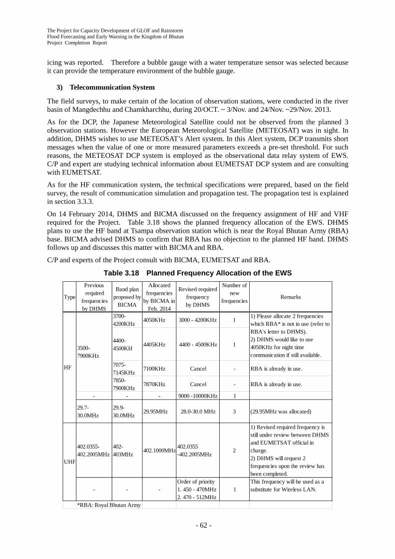
The Project for Capacity Development of GLOF and Rainstorm Flood Forecasting and Early Warning in the Kingdom of Bhutan Project Completion Report
- 62 -
icing was reported. Therefore a bubble gauge with a water temperature sensor was selected because it can provide the temperature environment of the bubble gauge.
3) Telecommunication System
The field surveys, to make certain of the location of observation stations, were conducted in the river basin of Mangdechhu and Chamkharchhu, during 20/OCT. ~ 3/Nov. and 24/Nov. ~29/Nov. 2013.
As for the DCP, the Japanese Meteorological Satellite could not be observed from the planned 3 observation stations. However the European Meteorological Satellite (METEOSAT) was in sight. In addition, DHMS wishes to use METEOSAT’s Alert system. In this Alert system, DCP transmits short messages when the value of one or more measured parameters exceeds a pre-set threshold. For such reasons, the METEOSAT DCP system is employed as the observational data relay system of EWS. C/P and expert are studying technical information about EUMETSAT DCP system and are consulting with EUMETSAT.
As for the HF communication system, the technical specifications were prepared, based on the field survey, the result of communication simulation and propagation test. The propagation test is explained in section 3.3.3.
On 14 February 2014, DHMS and BICMA discussed on the frequency assignment of HF and VHF required for the Project. Table 3.18 shows the planned frequency allocation of the EWS. DHMS plans to use the HF band at Tsampa observation station which is near the Royal Bhutan Army (RBA) base. BICMA advised DHMS to confirm that RBA has no objection to the planned HF band. DHMS follows up and discusses this matter with BICMA and RBA.
C/P and experts of the Project consult with BICMA, EUMETSAT and RBA.
Table 3.18 Planned Frequency Allocation of the EWS
Type
Previous required
frequenciesby DHMS
Band planproposed by
BICMA
Allocatedfrequencies
by BICMA inFeb. 2014
Revised requiredfrequencyby DHMS
Number ofnew
frequenciesRemarks
3700-4200KHz
4050KHz 3000 - 4200KHz 1
4400-4500KH
4405KHz 4400 - 4500KHz 1
7075-7145KHz
7100KHz Cancel - RBA is already in use.
7850-7900KHz
7870KHz Cancel - RBA is already in use.
- - - 9000 -10000KHz 1
29.7-30.0MHz
29.9-30.0MHz
29.95MHz 28.0-30.0 MHz 3 (29.95MHz was allocated)
402.0355-402.2005MHz
402-403MHz
402.1000MHz402.0355-402.2005MHz
2
1) Revised required frequency isstill under review between DHMSand EUMETSAT official incharge.2) DHMS will request 2frequencies upon the review hasbeen completed.
- - -Order of priority1. 450 - 470MHz2. 470 - 512MHz
1This frequency will be used as asubstitute for Wireless LAN.
*RBA: Royal Bhutan Army
3500-7900KHz
1) Please allocate 2 frequencieswhich RBA* is not in use (refer toRBA's letter to DHMS).2) DHMS would like to use4050KHz for night timecommunication if still available.3) f 3000 4 00 i f ll
UHF
HF

The Project for Capacity Development of GLOF and Rainstorm Flood Forecasting and Early Warning in the Kingdom of Bhutan
Project Completion Report
- 63 -
4) Flood Warning Siren Tower
The proposed installation sites for flood warning siren towers (three in Mangdechhu and six in Chamkharchhu) were identified and determined with DHMS C/P through the field reconnaissance and the discussion with local stakeholders on November 24 to 28, 2013. The outline of the proposed sites are shown in Table 3.19.
Then, DHMS started required formalities for land allocation for proposed sites to district land allocation committee and NLCS after December 2013. DHMS C/P again discussed with the district land lease committee on March 3 - 4, 2014. DHMS practically completed all the land allocation by May 2014.
Table 3.19 Proposed Installation Sites of Flood Warning Siren Towers Mangdechhu Basin No. Name of
Siren Towers
Location of Installation Sites Local Focal Person Discussed Description Land
Classification Latitude Longitude Name Organization &
Position 1 Bjizam
Village Grounds of Bjizam Primary School
Government land (School grounds)
27°31'20.35"N 90°27'29.32"E Mr. Sonam Tobgyel
Principal of the School
Mr. Kinzang
Dzongkhag Education Officer
2 Dam Site Left bank next to the dam crest (under construction)
Grounds of MHPA
- - Mr. Karma Chhophel
Chief engineer of Mangdechhu Hydroelectric Project Authority
3 Power Plant Grounds of the power plant (under construction)
Grounds of MHPA
- - Mr. Karma Chhophel
Chief engineer of Mangdechhu Hydroelectric Project Authority
Chamkharchhu Basin No. Name of
Siren Towers
Location of Installation Sites Local Focal Person Discussed Description Land
Classification Latitude Longitude Name Organization &
Position 1 Choekhor
Toe Primary School
Higher ground in the school grounds
Government land (School grounds)
27°40'28.00"N 90°44'06.06"E Mr. Pema Thinley
Off. Principal of the School
Mr. Taw Tshering
Principal of the School
2 Kurjey Village
Above proposed AWLS on the left bank
Government land
27°35'34.57"N 90°44'06.06"E Mr. Tashi Wangdi
Mang Ap of Choekhor Gewog
3 Wangdicholing Village
Grounds of Wangdicholing General Hospital
Government land (Hospital grounds)
27°33'33.30"N 90°44'41.02"E
Mr. Namgyal Dorji
Health Administrative Officer
Mr. Pema Jamtsho
Thueme of Chamkhar Thromde
4 Bumthang Downtown
Slope near town entrance gate
Government land
27°32'51.78"N 90°45'13.68"E Mr. Pema Jamtsho
Thueme of Chamkhar Thromde
5 Gangrithang Primary School
Higher ground in the school grounds
Government land (School grounds)
27°32'54.90"N 90°45'34.17"E Mr. Jamtho Principal of the School
Mr. Pema Jamtsho
Thueme of Chamkhar Thromde
6 Gyelkhar Village
Big rock near the left bank of Chamkharchhu
Government land
27°32'13.68"N 90°45'42.30"E Mr. Pema Jamtsho
Thueme of Chamkhar Thromde

The Project for Capacity Development of GLOF and Rainstorm Flood Forecasting and Early Warning in the Kingdom of Bhutan Project Completion Report
- 64 -
5) Preparation of Draft Technical Specification for EWS
Draft Technical Specification for EWS was prepared based on the field inspection, hydrological condition and considering existing observation stations. The draft specification has been submitted to JCC meeting and agreed by JCC members on 7 February 2014.
6) Preparatory Construction Work for EWS (Local Subcontract)
(1) Background
Access to the sites of AWS and AWLS is difficult in the rainy season as well as rainfall time in the dry season. Construction works cannot be conducted in winter because of coldness. Therefore the period while construction works can be done is very short. The installation of the equipment may not be completed in the period, if the contractor procuring the equipment conducts fundamental construction such as felling trees, levelling the sites or constructing fencing. It is also difficult for the contractor to select an appropriate contractor and execute the management of the construction in the short period. Therefore the fundamental part of the construction work such as levelling, fencing and so on was conducted in the Project to avoid the delay risk of installing the equipment.
(2) Consideration of technical specification
The contents of the precursory construction works carried out by a subcontractor in the Project were decided on the reconstruction of the cableway shed at Bjizam and levelling and constructing fencing at the site of Jongthang, Kurjey, Kagthang and Tsampa. The technical specifications, drawings, bill of quantities and draft of the contract document were produced in cooperation with the C/P of DHMS after the field visit of the sites.
Figure 3.22 Some of the Drawings of Precursory Construction Works
(3) Local Subcontract
The submission of the quotation of the construction works was requested on 27 February 2014 to three possible contractors which had done similar works. The quotations were opened on 4 March and the contractor was decided on 6 March after contractual negotiation. The sites of the construction works were shown to the contractor and the works were confirmed by the contractor and C/P on 9-12 March. The procedure obtaining permission for felling trees was conducted in the same period. The contract was made on 28 March and the contractor began the construction works in the same day.
The Project for Capacity Development of GLOF and Rainstorm Flood Forecasting and Early Warning in the Kingdom of Bhutan
Project Completion Report
- 65 -
(4) Management of Construction Work
The management of the subcontractor’s works was executed with the C/P of DHMS and the works were completed satisfactorily on 15 June 2014 within the contract period.
7) Field Test of Wireless Communication
The field test of 29.8 MHz HF wireless communication is used in the EWS of the Project was executed on 19 and 20 May 2014 with the cooperation of C/P of DHMS. The intensity of receiving radio waves was measured on three test paths selected based on the difficulty of wireless communication. The result was applied to the simulation of wireless communication and the technical specifications of HF radio set and its antennas were decided.
3.3.4 Installation of EWS Equipment into Pilot Basins (Activity 2-4)
All equipment for EWS is directory procured by JICA Headquarters via open tendering. The bidding has already been done on August 2014, five months delay from the original schedule. The detail procedure to prepare the tendering documents is shown in Table 3.20.
Table 3.20 Preparation of Tendering Documents Date Works
31 / 01 / 2014 Submission of 1st draft of specification forms for public announcement 25 / 02 / 2014 Teleconference with INTEM Consultant who contracted to prepare specification forms 07 / 03 / 2014 Meeting with INTEM Consultant to reassembling of the specification forms 14 / 03 / 2014 (Interrupt of specification preparation works) 22 / 04 / 2014 Submission of 2nd draft of reassembled specification forms 09 / 05 / 2014 Meeting with INTEM Consultant to recommence the preparation works 21 / 05 / 2014 Submission of 3rd draft of specification forms with some revisions of condition 04 / 06 / 2014 (Breakaway of INTEM from specification preparation works) 16 / 06 / 2014 Meeting with JICA office to accelerate specification preparation works 20 / 06 / 2014 Meeting with JICA HQ to confirm schedule of specification preparation works 04 / 07 / 2014 Meeting with JICA HQ to confirm inspection procedures 11 / 07 / 2014 Meeting with JICA HQ to confirm schedule of public announcement 14 / 07 / 2014 Finalization and submission of the speciation forms 18 / 07 / 2014 Public announcement
1) Supporting Preliminary Site Survey
Preliminary site survey by the JICA Contractor has been conducted in order to confirm the site condition and the radio communication as well as logistics for the installation in the period of September 28, 2014 to October 7, 2014. DHMS and the JICA Expert Team has worked together to obtain visa clearance and necessary permits for the Contractor. DHMS and the JICA Expert Team have also attended the entire period of the site survey shown in Table 3.21.
As a result of the radio communications test, most of the sites can receive enough radio intensities excepting the sites of Tsampa AWS in the Chamkharchhu river basin and Power Plant siren tower in the Mangdechhu river basin. Accordingly, the JICA Contractor proposed that Kagthang AWLS would have a “Store and Forward” function to relay the radio signal from the Tsampa AWS to the Kurjey control room, and the Power Plant siren tower would be installed on a hill at the some distance from the original planed location. DHMS and the JICA Expert Team have agreed to the proposal.
As for the radio communication tower planned to install into Trongsa District Office premises, special consideration is necessary due to the landscape conservation and the cultural importance of the Office Building (Dzong). Therefore, Trongsa District Office and DHMS have submitted an application for permission to install the radio communication antenna to the Ministry of Home and Cultural Affairs.
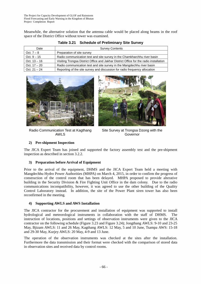
The Project for Capacity Development of GLOF and Rainstorm Flood Forecasting and Early Warning in the Kingdom of Bhutan Project Completion Report
- 66 -
Meanwhile, the alternative solution that the antenna cable would be placed along beams in the roof space of the District Office without tower was examined.
Table 3.21 Schedule of Preliminary Site Survey Date Survey Contents
Oct. 7 – 8 Preparation of site survey Oct. 9 – 15 Radio communication test and site survey in the Chamkharchhu river basin Oct. 13 – 16 Visiting Trongsa District Office and Jakhar District Office for the radio installation Oct. 17 – 20 Radio communication test and site survey in the Mangdechhu river basin Oct. 21 – 24 Reporting of the site survey and discussion for radio frequency allocation
Radio Communication Test at Kagthang
AWLS Site Survey at Trongsa Dzong with the
Governor
2) Pre-shipment Inspection
The JICA Expert Team has joined and supported the factory assembly test and the pre-shipment inspection as described in section 3.2.2.
3) Preparation before Arrival of Equipment
Prior to the arrival of the equipment, DHMS and the JICA Expert Team held a meeting with Mangdechhu Hydro Power Authorities (MHPA) on March 4, 2015, in order to confirm the progress of construction of the control room that has been delayed. MHPA proposed to provide alterative building in the Security Division & Fire Fighting Unit Office in the dam colony. Due to the radio communications incompatibility, however, it was agreed to use the other building of the Quality Control Laboratory instead. In addition, the site of the Power Plant siren tower has also been reconfirmed in the meeting.
4) Supporting AWLS and AWS Installation
The JICA contractor for the procurement and installation of equipment was supported to install hydrological and meteorological instruments in collaboration with the staff of DHMS. The instruction of locations, positions and settings of observation instruments were given to the JICA contractor on the following schedule (Figure 3.23 and Figure 3.24); Jongthang AWLS: 9-10 and 23-25 May, Bjizam AWLS: 11 and 26 May, Kagthang AWLS: 12 May, 5 and 10 June, Tsampa AWS: 15-18 and 29-30 May, Kurjey AWLS: 20 May, 4-9 and 13 June.
The operation of the observation instruments was checked at the sites after the installation. Furthermore the data transmission and their format were checked with the comparison of stored data in observation sites and received data by control rooms.
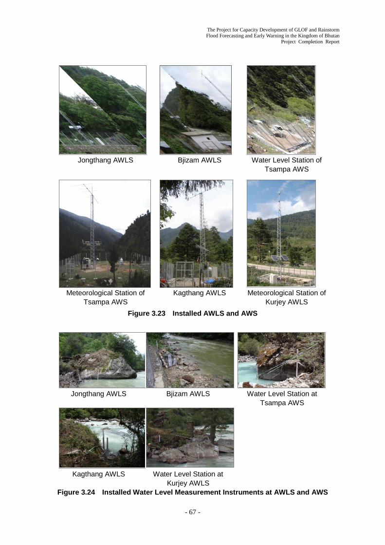
The Project for Capacity Development of GLOF and Rainstorm Flood Forecasting and Early Warning in the Kingdom of Bhutan
Project Completion Report
- 67 -
Jongthang AWLS Bjizam AWLS Water Level Station of
Tsampa AWS
Meteorological Station of
Tsampa AWS Kagthang AWLS Meteorological Station of
Kurjey AWLS Figure 3.23 Installed AWLS and AWS
Jongthang AWLS Bjizam AWLS Water Level Station at
Tsampa AWS
Kagthang AWLS Water Level Station at Kurjey AWLS
Figure 3.24 Installed Water Level Measurement Instruments at AWLS and AWS

The Project for Capacity Development of GLOF and Rainstorm Flood Forecasting and Early Warning in the Kingdom of Bhutan Project Completion Report
- 68 -
5) Assisting Installation Works for NWFWC and Control Rooms
DHMS and the JICA expert assisted the JICA Contractor to conduct following installation work,
- 24, 25 April 2015: The HF antenna installation point was decided at NWFWC.
- 30, 31 April: The frequencies of radio communication, which would be used in the field observation sites, were coordinated between DHMS/JICA Contractor and BICMA.
- 7,8 June: Installation work of the monitoring PC and adjustment of the radio communication instrument were assisted at Mangdechhu Control room (MHPA Dam colony) .
- 9,10 June: Installation work of the monitoring PC and adjustment of the radio communication instrument were assisted at Chamkharchhu Control room (Kurjey). DHMS got Internet circuit open for action.
Installation work at Control room (MHPA Dam Colony)
Layout of Control room (Kurjey)
Adjustment of HF Antenna (Kurjey)
Application for Internet Connection (Bumthang)
6) Assisting Installation Work at Warning Siren Tower and District Offices
- 7, 8 June 2015: Installation work of Bjizam Siren Tower and adjustment of radio communication instrument were assisted in Mangdechhu basin.
- 9, 10 June: Installation work of 6 Siren Towers and adjustment of radio communication instrument were assisted in Chamkharchhu basin.

The Project for Capacity Development of GLOF and Rainstorm Flood Forecasting and Early Warning in the Kingdom of Bhutan
Project Completion Report
- 69 -
7) Supporting Software Development
After the preliminary site survey, the JICA Expert Team and the JICA Contractor have continued to discuss user-interfaces for the system of the central operation center and control rooms in the basins in consideration of DHMS’s requests. Accordingly, the main interfaces is divided into two (2) parts, one is “flood monitoring interface” showing graphs of water level, rainfall and meteorological observed data in the large screen, the other is “operation interface” to control sirens and radio communications.
A prototype of the software was prepared and explained to DHMS by the JICA Contractor at NWFWC on June 4, 2015. Because the communication scheme of the new system is rather complicated compering with the existing EWS in the Punatsangchhu river basin developed by SUTRON, USA, the user-interfaces are also cumbersome. So far, the full function of the prototype has been unable to be examined because the radio communications have not been established at the moment. Therefore, it was confirmed that DHMS and the JICA Expert Team would sort out the necessary modifications and request to JICA Contractor to modify the interfaces after establishment of the full radio communications.
The JICA Expert Team and JICA Contractor held a meeting in Tokyo on June 23, 2015, and concluded that the Contractor works for the modification and finalize it in September before OJT in the early October. The updated prototype EWS user-interfaces are shown in Figure 3.25.
Flood Monitoring Interface Operation Interface
Figure 3.25 Prototype EWS User-interfaces
8) Setting Threshold of Water Level for Early Warning
The thresholds of the water level at each observation site have been discussed among DHMS and the JICA Expert Team. In consideration of coherency with the existing EWS in the Punatsangchhu river basin, the thresholds are comprised of 2 levels of “Alert” and “Alarm”. When the water level rising to the Alert Level at any observation stations, beep sound will be generated in the control room. If
Siren Tower at Bjizam Village Siren Tower at Bumthang Downtown
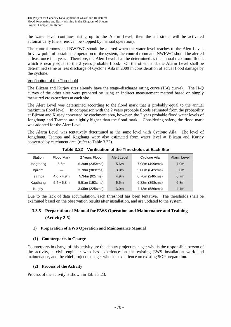
The Project for Capacity Development of GLOF and Rainstorm Flood Forecasting and Early Warning in the Kingdom of Bhutan Project Completion Report
- 70 -
the water level continues rising up to the Alarm Level, then the all sirens will be activated automatically (the sirens can be stopped by manual operation).
The control rooms and NWFWC should be alerted when the water level reaches to the Alert Level. In view point of sustainable operation of the system, the control room and NWFWC should be alerted at least once in a year. Therefore, the Alert Level shall be determined as the annual maximum flood, which is nearly equal to the 2 years probable flood. On the other hand, the Alarm Level shall be determined same or less discharge of Cyclone Aila in 2009 in consideration of actual flood damage by the cyclone.
Verification of the Threshold
The Bjizam and Kurjey sites already have the stage–discharge rating curve (H-Q curve). The H-Q curves of the other sites were prepared by using an indirect measurement method based on simply measured cross-sections at each site.
The Alert Level was determined according to the flood mark that is probably equal to the annual maximum flood level. In comparison with the 2 years probable floods estimated from the probability at Bjizam and Kurjey converted by catchment area, however, the 2 yeas probable flood water levels of Jongthang and Tsampa are slightly higher than the flood mark. Considering safety, the flood mark was adopted for the Alert Level.
The Alarm Level was tentatively determined as the same level with Cyclone Aila. The level of Jongthang, Tsampa and Kagthang were also estimated from water level at Bjizam and Kurjey converted by catchment area (refer to Table 3.22).
Table 3.22 Verification of the Thresholds at Each Site
Station Flood Mark 2 Years Flood Alert Level Cyclone Aila Alarm Level
Jongthang 5.6m 6.30m (235cms) 5.6m 7.98m (499cms) 7.9m
Bjizam ― 3.78m (303cms) 3.8m 5.00m (642cms) 5.0m
Tsampa 4.6~4.9m 5.34m (92cms) 4.9m 6.76m (240cms) 6.7m
Kagthang 5.4~5.8m 5.51m (153cms) 5.5m 6.82m (398cms) 6.8m
Kurjey ― 3.05m (225cms) 3.0m 4.13m (586cms) 4.1m
Due to the lack of data accumulation, each threshold has been tentative. The thresholds shall be examined based on the observation results after installation, and are updated to the system.
3.3.5 Preparation of Manual for EWS Operation and Maintenance and Training (Activity 2-5)
1) Preparation of EWS Operation and Maintenance Manual
(1) Counterparts in Charge
Counterparts in charge of this activity are the deputy project manager who is the responsible person of the activity, a civil engineer who has experience on the existing EWS installation work and maintenance, and the chief project manager who has experience on existing SOP preparation.
(2) Process of the Activity
Process of the activity is shown in Table 3.23.

The Project for Capacity Development of GLOF and Rainstorm Flood Forecasting and Early Warning in the Kingdom of Bhutan
Project Completion Report
- 71 -
Table 3.23 Activity Process on Preparation of EWS O&M Manual
DHMS set a EWS against GLOF up in Punatsangchhu river basin funded by UNDP in 2011. And DHMS has operated and maintained the EWS since the completion. The existing EWS is a large scale system as 10 automatic water level stations (AWLS) and 18 siren stations (SS).
The project introduces the second case of EWS into Bhutan in the Mangdechhu and Chamkharchhu river basins. DHMS also handles the new EWS. The activity has to reflect the actual condition of the existing EWS and related documents into the operation and maintenance manual for the new EWS in order to DHMS can handle smoothly the new EWS making use of own experience on the existing EWS. It was agreed that the basic policy of the activity is as mentioned above at the meeting on 1st May 2015.
The related prime documents of operation and maintenance for the existing EWS are described as below; 1) Standard Operating Procedure (SOP) for the GLOF Early Warning System Installed along the
Punakha-Wangdue Valley (Version2.0, April 2014); DHMS 2) Bhutan GLOF-Early Warning System Control room Software Version 2.0 Operator’s Manual
November, 2013; Sutron Corporation 3) Bhutan GLOF Early Warning System in the Punakha-Wangdi Valley Consisting of Stream Gauge
Stations Hydromet Stations and Siren Stations; Sutron Corporation
DHMS compiled document 1) by itself as a rule book. The contents are an overview of GLOF and EWS, authority and responsibility of administrative organization, components of EWS, maintenance service, warning service, public information and education, duties and responsibilities for monitoring personnel. document 2) describes specifically operation of the system software. document 3) is a compiled instruction handbook for each module. Both of them are written by Sutron Corporation who manufactured and installed the system.
If the activity separately develops a new manual then the double standard makes the staff confused. The activity started to revise the existing SOP (document 1) into common applicable version for both of the existing and the new EWS in order to avoid confusion. According to the contract specification,
Day Month Year
2130
529
1030
1
DateActivity Contents
20April
2015
Meeting Work Policy, Schedule
1
May
Meeting Work Policy, Site Inspection 2
WritingChecking
O/M Manual for Mangdechhu and Chamkahrchhu
3
4 Inspection COS in ThimpuInterface, Siren Logic
6
7 Inspection CNC, AWLS, SS in Trongsa Initial Adjustment Work
3June
Meeting SOP should be shelved Contents of O/M Manual
3
Participant/ Executant
8 Inspection CNC, AWLS, SS in Bhumtang Instlation of Bubbler
5
WritingChecking
SOP revised version Draft 2
1
3 Inspection CR and AWLS ofPunatsangchhu EWS
6
Review SOP, Operation Manual ofPunatsangchhu EWS
-
The Project for Capacity Development of GLOF and Rainstorm Flood Forecasting and Early Warning in the Kingdom of Bhutan Project Completion Report
- 72 -
the JICA Contractor has to provide an operation manual for the system software and the instruction handbooks for equipment. The activity intended to appropriate them for document 2) and 3).
The activity team visited the Wangdue Control room and the Yabesa AWLS of the existing EWS on 3rd May 2015 to figure out the actual operation and maintenance situation. It is confirmed that the situation is fairly good but there are no log books of operation and maintenance. Another point is that preventive maintenance is absent, actual maintenance is implemented only in case of malfunction.
An outline of the revised SOP draft based on the existing SOP has been completed by the end of May 2015. The activity team held a meeting on 1st June 2015 and it was agreed that the contents of the revised SOP draft shall be changed as described below
The revised SOP draft includes administrative terms such as governing organization and budgetary procedures. However required output of the project is consistently the manual which has more limited contents as practical operation and maintenance for the new EWS. Therefore the contents shall be changed to equate the project required output as described below.
Name of the output is not “SOP” but “Operation and Maintenance (O/M) Manual”.
Targets are limited Mangdechhu and Chamkharchhu river basins.
The contents shall be;
- Basic knowledge that should be possessed by staff in the Control Room and NWFWC (river basin condition, flood characteristics, alarm water level, flood arrival time, hazard area).
- Outline of installed EWS such as system configuration and communication detail (transmission interval, transmission scheme, voice message etc.)
- Operation of monitoring and manipulation system (software)
- Operator’s action under alert and alarm condition
- Regular maintenance for equipment and sensors. Recording log books.
The O/M Manual has been drafted for June 2015 along the policy mentioned above.
The activity team implemented on-site inspection of installation and regulation work in the Mangdechhu and Chamkharchhu river basins by JICA Contractor with support of DHMS and JICA Experts on 7 and 8 June 2015. The activity team studied equipment of the new EWS and installation environment.
(3) Contents of the Draft Manual
Contents and progress of the O/M Manual are shown in Table 3.24. The manual for the Chamkharchhu basin has the same contents but endemic information. Chapter 5 has been blank because the software operating manual by the JICA contractor has been unfinished. The Manual is perfected in the second phase after submission of the contractor’s manual.

The Project for Capacity Development of GLOF and Rainstorm Flood Forecasting and Early Warning in the Kingdom of Bhutan
Project Completion Report
- 73 -
Table 3.24 Contents and Progress of EWS Operation and Maintenance Manual
2) Training Based on the Draft Manual
(1) Training for Central DHMS Staff
Training based on the O/M Manual draft for the hydrology division staff was organized on 29th June 2015. 10 counterparts took part in the training.
Topics of the training are described as below.
Draft Blank Remark1.1 What is this Book ✓
1.2 Scope of this Book ✓
2.1 Flood ✓
2.2 Flood Countermeasure ✓
2.3 FEWS ✓
3.1 Outline ✓
3.2 Glacial Lakes ✓
3.3 Probable Flood Discharge ✓
3.4 Flood Arrival Time ✓
3.5 Flood Prone Areas ✓
3.6 Dam and Power Plant ✓
4.1 Whole System ✓
4.2 FEWS ✓
4.3 Main Communication Way ✓
4.4 Equipment of Each Station ✓Waiting manual by manufacturer
5.1 Operation under Alarm ✓
5.3 Operation in Normal Condition ✓
6.1 Warning Process ✓
6.2 In Case of GLOF ✓
6.3 in Case of RSF ✓
6.4 Information Sharing with NWFFWC ✓
6.5 False Alarm ✓
7.1 Type of Maintenance and Unit in charge ✓
7.2 Daily Check ✓
7.3 Quarterly Maintenance ✓
7.4 Repair Work ✓
7.5 Spare Parts ✓
7.6 Tools and Equipment ✓
8.1 Principle ✓
8.2 Setup the Value ✓
8.3 Threshold Water Levels at Jongthang AWLS ✓
8.4 Threshold Water Levels at Bjizam AWLS ✓
Maintenance Service
Thereshold Water levels at the AWLSs
Waiting manual by manufacturer
Chapter
Basic Knowledge
IntroductionSection
1
2
3
7
8
OPERATION AND MAINTENANCE MANUAL FOR THE FLOOD EARLY WARNING SYSTEM (FEWS)THE MANGDECHHU FEWS DRAFT JUNE 2015
Characteristics ofthe Mangdechhu Basin
Operation of the System
The System
Warning Service
4
5
6
The Project for Capacity Development of GLOF and Rainstorm Flood Forecasting and Early Warning in the Kingdom of Bhutan Project Completion Report
- 74 -
Difference between GLOF and rainstorm flood
Meaning of “Early” in the EWS
Which is worse, “Air shot” or “Miss”?
Necessity of threshold review by actual data
Common and different points between the Existing and the New EWS
Importance of keeping records such as log book
(2) Hands-on Trainings
The EWS installation works by JICA Contractor was delayed Therefore, hands- on trainings using installed EWS for NWFWC and two Control room staff were postponed in the 2nd Phase (September 2015 -).
3.4 Achievements of Output 3 Activities
All the Project activities on Output 3 “Emergency response capacity against GLOF/rainstorm flood at central and local level is enhanced in the pilot basins” in the 1st Phase (September 2013 - July 2015) are described in this section.
The following activities implemented in the 2nd Phase (September 2015 – September 2016) are excluded.
- Develop SOP for GLOF/rainstorm flood in pilot basins (Activity 3-4)
3.4.1 Review Flood Emergency Response on Warning and Evacuation in the Pilot Basins (Activity 3-1)
1) Kick-off Workshop at the Central Level
The Community-based Disaster Risk Management (hereinafter referred to as “CBDRM”) kick-off meeting was held on September 25th, 2014 at DDM with the participation of the Director of DDM, 7 staff of DDM, DHMS, JICA Experts and to introduce the objectives of the activities and planned activities as well as to clarify the role of DDM in the activities. The DDM has confirmed their involvement on the proposed activities at the District and Local levels. At the same time, the DDM has also discussed their efforts on capability building on CBDRM/disaster risk reduction planning. The DDM has conducted a sensitization session for communities along the Chamkharchhu. Safe areas were identified for each community in the event of GLOF occurring. Also, DDM has been conducting CBDRM training to develop CBDRM trainers. 36 officials from Bumthang were trained. Additionally, DDM has developed planning templates for Gewog (county) and Chiwog (sub-county) levels. The DDM also introduced their current manual on comprehensive CBDRM, and it was promised that The JICA Expert on CBDRM collaborating with the DDM was to review the draft manual towards finalization. The manual was reviewed in July 2015 as planned.
2) Kick-off Workshop at the District Level
Two workshops were conducted at the district level: At Trongsa District on September 29th, 2014 and at Bumthang District on October 1st, 2014. In the meetings the JICA Expert Team and C/Ps from DHMS and DDM introduced the Project and presented the proposed activities in the target communities, as well as the proposed approach to work with vulnerable communities. In Trongsa district, 15 participants from different government sectors, led by the Governor of Trongsa, engaged in the discussion after

The Project for Capacity Development of GLOF and Rainstorm Flood Forecasting and Early Warning in the Kingdom of Bhutan
Project Completion Report
- 75 -
the presentation. The Police were interested to know their role in the event of a flood. In Bumthang District, 17 participants representing the different government sector provided input on the direction the CBDRM activities may proceed. Participants mentioned that awareness-raising about the flood and the early warning system to be set-up to warn the public should also target travellers who frequently visit Bumthang Town. In both Districts, the different sector representatives expressed their support for the Project.
3) Kick-off Workshop at the Local Level
Three residential communities and one school community were initially proposed for evacuation planning using CBDRM. These were: Bjizam in Trongsa District, Wangdicholing, Chamkhar Town and Gangrithang Primary School in Bumthang District. Workshops were conducted in those communities and one school from September 30th to October 9th, 2014 to introduce the objectives of the Project, to review any existing flood warning or flood response practices, and to determine the level of interest and, therefore, the level of expected participation in each proposed community. All the communities showed high interest, and participants gave comments such as that all residents in vulnerable area (beside the river) should be invited to the planning workshop because the installation of siren would help the communities. Table 3.25 shows the number of participants in the kick-off workshops.
Table 3.25 Number of Participants for Kick-off Meeting
Workshop Location
Date (YYYY/MM
/DD)
Number of Participants
Total Central District Gewog/
Tromde Community DHMS DDM
Central/DDM 2014/9/25 2 8 10 Trongsa District 2014/09/30 1 1 14 1 17 Bumthang District 2014/10/01 1 1 16 1 19 Bjizam 2014/09/30 1 1 1 2 10 15 Wangdicholing 2014/10/07 1 1 11 13 Chamkhar Town 2014/10/07 1 1 1 21 24 Gangrithang Primary School
2014/10/09 1 1 2
Meetings were also held in Chokhortoe Primary School, the surrounding area of the school, Kurjey and Gyelkhar/Gongkhar, where the sirens have been installed to introduce the Project as well as to discuss the contents of activities.
3.4.2 Target Communities and Flood Warning Criteria in the Pilot Basins (Activity 3-2)
1) Preliminary Study
The preliminary study for selecting four target communities (and schools) for CBDRM from nine proposed warning siren installation sites is shown in Table 3.26.

The Project for Capacity Development of GLOF and Rainstorm Flood Forecasting and Early Warning in the Kingdom of Bhutan Project Completion Report
- 76 -
Table 3.26 Preliminary Information for Selecting Target Communities for CBDRM Mangdechhu Basin No. Name of Candidate
Community (Warning Siren Tower
Installation Sites)
General of the Community Selection Priority
Output 3 Activity
1 Bjizam Village The only small community with a few vulnerable households along the river in the Project Area (There is no other choice.)
Middle CBDRM
2 Dam Site Under construction and no permanent dam community (colony) so far <Out of objective of CBDRM, Objective of SOP>
- - 3 Power Plant
Chamkharchhu Basin 1 Choekhor Toe Primary
School -Located on the flood plain -83 pupils and 9 teachers -Quake mock drill every month -School has school disaster management plan
Middle Explanatory meeting on the installed siren
2 Kurjey Village
-More than a dozen scattered vulnerable households -Specific vulnerable households are not yet identified.
Middle Explanatory meeting on the installed siren
3 Wangdicholing Village -More than a dozen vulnerable households -Under the danger of riverbank erosion as well as flooding
High CBDRM
4 Bumthang Downtown -Dense urban area (a hundred and several tens of households) -Several dozen vulnerable households
High CBDRM
5 Gangrithang Primary School
-Located on the flood plain -Most dense population (377 pupils and 15 teachers) during daytime -Quake mock drill every month -School has school disaster management plan
High CBDRM
6 Gyelkhar Village -A few vulnerable households -Population might be increased in future
Low Explanatory meeting on the installed siren
2) Mangdechhu Basin
In Mangdechhu Basin, Bjizam was selected after careful study in collaboration with the DDM and DHMS. The EWS siren under the Project was installed in June 2015 in the community. Flood warning and evacuation plan would be needed for Bjizam and, therefore, more workshops to develop the evacuation plan as well as practice the plan through evacuation drill have been recommended.
3) Chamkharchhu Basin
Two major factors were used to identify the target communities along the Chamkharchhu. These are the location of the flood warning siren and the exposure (vulnerability) of the communities to Flood (Population density, risk level and community cohesion). Through careful discussion with the DDM
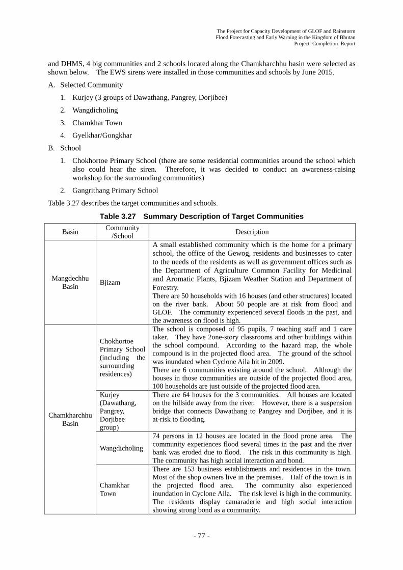
The Project for Capacity Development of GLOF and Rainstorm Flood Forecasting and Early Warning in the Kingdom of Bhutan
Project Completion Report
- 77 -
and DHMS, 4 big communities and 2 schools located along the Chamkharchhu basin were selected as shown below. The EWS sirens were installed in those communities and schools by June 2015.
A. Selected Community
1. Kurjey (3 groups of Dawathang, Pangrey, Dorjibee)
2. Wangdicholing
3. Chamkhar Town
4. Gyelkhar/Gongkhar
B. School
1. Chokhortoe Primary School (there are some residential communities around the school which also could hear the siren. Therefore, it was decided to conduct an awareness-raising workshop for the surrounding communities)
2. Gangrithang Primary School
Table 3.27 describes the target communities and schools.
Table 3.27 Summary Description of Target Communities
Basin Community /School Description
Mangdechhu Basin Bjizam
A small established community which is the home for a primary school, the office of the Gewog, residents and businesses to cater to the needs of the residents as well as government offices such as the Department of Agriculture Common Facility for Medicinal and Aromatic Plants, Bjizam Weather Station and Department of Forestry. There are 50 households with 16 houses (and other structures) located on the river bank. About 50 people are at risk from flood and GLOF. The community experienced several floods in the past, and the awareness on flood is high.
Chamkharchhu Basin
Chokhortoe Primary School (including the surrounding residences)
The school is composed of 95 pupils, 7 teaching staff and 1 care taker. They have 2one-story classrooms and other buildings within the school compound. According to the hazard map, the whole compound is in the projected flood area. The ground of the school was inundated when Cyclone Aila hit in 2009. There are 6 communities existing around the school. Although the houses in those communities are outside of the projected flood area, 108 households are just outside of the projected flood area.
Kurjey (Dawathang, Pangrey, Dorjibee group)
There are 64 houses for the 3 communities. All houses are located on the hillside away from the river. However, there is a suspension bridge that connects Dawathang to Pangrey and Dorjibee, and it is at-risk to flooding.
Wangdicholing
74 persons in 12 houses are located in the flood prone area. The community experiences flood several times in the past and the river bank was eroded due to flood. The risk in this community is high. The community has high social interaction and bond.
Chamkhar Town
There are 153 business establishments and residences in the town. Most of the shop owners live in the premises. Half of the town is in the projected flood area. The community also experienced inundation in Cyclone Aila. The risk level is high in the community. The residents display camaraderie and high social interaction showing strong bond as a community.

The Project for Capacity Development of GLOF and Rainstorm Flood Forecasting and Early Warning in the Kingdom of Bhutan Project Completion Report
- 78 -
Basin Community /School Description
Gangrithang Primary School
The school has 280 pupils, 20 teaching staff and 1 caretaker. There are one-story and two-story classrooms, a two-story building for teachers, and one-story building as the principal’s quarters. All the buildings are in the projected flood area, and the risk in the school is high. The ground was inundated when Cyclone Aila hit.
Gyelkhar/ Gongkhar
Half of the community is in the projected flood area, but only farm lands and occasional cow sheds are located in the area. While there are a few houses located close to the flood prone areas, they are constructed on a cliff well above the projected flood level. The community was selected since there are farm lands and cow sheds at risk to flood and the residents can hear the siren.
3.4.3 Plan and Conduct Evacuation Drill in the Pilot Basins (Activity 3-3)
Referring to the results of 3.4.2, Flood warning and Evacuation Plans were developed using the CBDRM approach at Bjizam in Trongsa, Wangdicholing, and Chamkhar Town in Bumthang. The two schools along Chamkharchhu have had experiences in developing a disaster management plan. While they have organized the disaster management team and some practices to evacuate during earthquake and flood, there is still a need to develop a flood evacuation plan in the light of the flood hazard map prepared by DHMS and the JICA Expert Team. Communities in the low-risk areas along the Chamkharchhu were guided to develop awareness-raising plan about the Flood EWS installed by the project. Table 3.28 describes the type of activities taken in the target communities and schools.
Table 3.28 Target Communities and Activities
River Basin Community Risk Level
Type of Activities based on EWS Warning Sirens Installed
Mangdechhu Bjizam High Flood warning evacuation planning + Evacuation drill
Chamkharchhu
Chokhortoe Primary School
(including surrounding communities)
High
(Low)
Revision of existing school disaster management plan + Evacuation drill (Surrounding communities: Awareness-raising planning)
Kurjey (Dawathang, Pangrey, Dorjibee group)
Low Awareness-raising planning + Demonstration of evacuation drill
Wangdicholing High Flood warning evacuation planning + Evacuation drill
Chamkhar Town High Flood warning evacuation planning + Evacuation drill
Gangrithang Primary School
High Revision of existing school disaster management plan + Evacuation drill
Gyelkhar/Gongkhar Low Awareness-raising planning + Demonstration of evacuation drill
1) Flood Warning Evacuation Planning Workshop
The flood warning evacuation planning workshops were conducted with the representatives of the communities in the following communities: Bjizam (June 10th and 11th, 2015), Wangdicholing (March 18th-20th, 2015) and Chamkhar Town (June 16th and 21st, 2015). All of the participants showed high interest on the workshops and they intensively participated in the workshops. The C/Ps from DDM, DHMS, District (District Disaster Focal Person), and Gewog (Gewog Administrative

The Project for Capacity Development of GLOF and Rainstorm Flood Forecasting and Early Warning in the Kingdom of Bhutan
Project Completion Report
- 79 -
Officer) also took the roles as facilitators with the JICA Expert Team. The following activities were taken in the workshops:
- Validated and updated of the hazard map
- Identified households and structures which are at-risk
- Selected safe evacuation place and evacuation route
- Prepared evacuation route map
- Formulated evacuation procedure
- Enumerated roles and responsibilities of evacuation management team
- Formulated action plan
In those activities, the participants took the initiative with guidance from JICA experts and C/Ps.
Regarding the evacuation management team, it was decided that 10 members were to be selected from the hill side of the communities in Bjizam and Wangdicholing. In Chamkhar Town, the participants chose to select cluster leaders, instead of forming the evacuation management team. The leaders will take the lead on warning, evacuation and evacuation site management.
In action plans, it was promised that the participants would inform the contents and outputs of the workshops to their Gewog and other residents and the organization of evacuation management teams. It was confirmed that the action plan was completed accordingly in Wangdicholing during the follow-up meeting which was conducted on June 20th, 2015. The members of the evacuation management team also participated in the meeting, and their specific assignment and roles and responsibilities were reviewed.
In the 2nd phase, training for the evacuation management teams and cluster leaders are given and evacuation drills are conducted later.
Selection of households who are at
risk Evacuation route map which was
drawn by participants
In those 3 communities, discussions on evacuation equipment were also conducted with the participants. The result of the discussions is shown in Table 3.29. The equipment procured in the 2nd phase of this project is used for the evacuation drills.
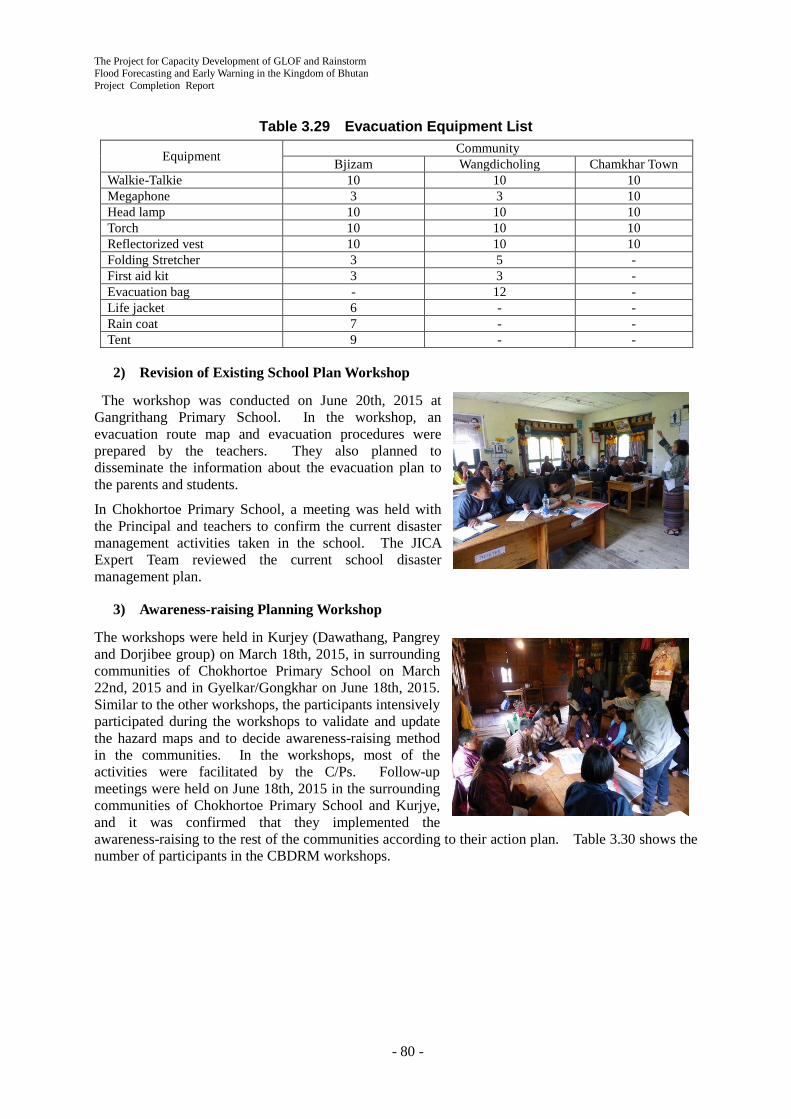
The Project for Capacity Development of GLOF and Rainstorm Flood Forecasting and Early Warning in the Kingdom of Bhutan Project Completion Report
- 80 -
Table 3.29 Evacuation Equipment List
Equipment Community Bjizam Wangdicholing Chamkhar Town
Walkie-Talkie 10 10 10 Megaphone 3 3 10 Head lamp 10 10 10 Torch 10 10 10 Reflectorized vest 10 10 10 Folding Stretcher 3 5 - First aid kit 3 3 - Evacuation bag - 12 - Life jacket 6 - - Rain coat 7 - - Tent 9 - -
2) Revision of Existing School Plan Workshop
The workshop was conducted on June 20th, 2015 at Gangrithang Primary School. In the workshop, an evacuation route map and evacuation procedures were prepared by the teachers. They also planned to disseminate the information about the evacuation plan to the parents and students.
In Chokhortoe Primary School, a meeting was held with the Principal and teachers to confirm the current disaster management activities taken in the school. The JICA Expert Team reviewed the current school disaster management plan.
3) Awareness-raising Planning Workshop
The workshops were held in Kurjey (Dawathang, Pangrey and Dorjibee group) on March 18th, 2015, in surrounding communities of Chokhortoe Primary School on March 22nd, 2015 and in Gyelkar/Gongkhar on June 18th, 2015. Similar to the other workshops, the participants intensively participated during the workshops to validate and update the hazard maps and to decide awareness-raising method in the communities. In the workshops, most of the activities were facilitated by the C/Ps. Follow-up meetings were held on June 18th, 2015 in the surrounding communities of Chokhortoe Primary School and Kurjye, and it was confirmed that they implemented the awareness-raising to the rest of the communities according to their action plan. Table 3.30 shows the number of participants in the CBDRM workshops.

The Project for Capacity Development of GLOF and Rainstorm Flood Forecasting and Early Warning in the Kingdom of Bhutan
Project Completion Report
- 81 -
Table 3.30 Number of Participants in CBDRM Workshops
Community Date
(YYYY/MM/ DD)
Workshop Participants Affected Population
Total Central District Gewog/ Tromde
Community
Directly Affected
Indirectly Affected DHMS DDM
Flood warning evacuation planning workshop Wangdicholing 2015/03/18-20 12 1 1 1 9 74 300 Bjizam 2015/06/10-11 25 1 1 1 22 51 150 Chamkhar Town 2015/06/16,21 18 1 1 16 580 1,000 Integration of existing flood evacuation plan workshop Gangrithang Primary School 2015/06/20 20 1 19 300 600
Awareness-raising planning workshop Kurjey 2015/03/18 10 1 1 1 1 6 440 500 Chockhortoe Primary School (Activity of the surrounding communities)
2015/03/22 9 1 1 1 6 600 200
Gyelkar/ Gongkar 2015/06/18 17 1 16 100 200
Total 111 5 2 7 3 94 2,145 2,950

The Project for Capacity Development of GLOF and Rainstorm Flood Forecasting and Early Warning in the Kingdom of Bhutan Project Completion Report
- 82 -
The 2nd Phase Achievements (Sep. 2015 –Sep. 2016) Chapter 4
This chapter compiles all the achievements of the Project activities in the 2nd Phase (September 2015 – September 2016).
4.1 Achievements Related to Entire Project
All the Project achievements related to the entire project in the 2nd Phase (September 2015 - September 2016) are described in this section.
4.1.1 Seminars
1) Science Workshop at CST
On March 26, 2016, DHMS and the JICA Project Team held a Science Workshop at the College of Science and Technology (CST), Phuntsholing to disseminate the Project information to CST students and lecturers. The presentation topics were 1) the outline and progress of the Project and 2) flood hazard map.
2) 2nd Annual Seminar
The 2nd Annual Seminar was held on June 14, 2016 aiming at sharing the Project achievements with many stakeholders. Reflecting the high ownership of the Bhutanese side, most of the presentations were done by the C/P staff including the presentation by the DHMS and DDM director. Around 70 participants, not only counterpart agencies, relevant agencies, district focal persons, donors, media, NGOs but also VIPs such as the Minister of Economic Affairs and several National Assembly members showed a high interest in the Project. The program and the participants list are shown in Appendix 8.
4.1.2 Counterpart Trainings in Japan
(1) General
The Counterpart Trainings in Japan implemented four times during the 2nd Phase (September 2015 - September 2016) are shown in Table 4.1.
Table 4.1 Record of C/P Training in Japan Type of training
Name of training Period Trainee
Duration (day)
Date Number Organization
Project custom-made
Administration on river management, EWS, weather observation and local government
12 Jan. 17 - 28, 2016 6 DHMS: 2 DoES NLCS DHS Trongsa District

The Project for Capacity Development of GLOF and Rainstorm Flood Forecasting and Early Warning in the Kingdom of Bhutan
Project Completion Report
- 83 -
Type of training
Name of training Period Trainee
Duration (day)
Date Number Organization
JICA ready-made
Comprehensive disaster risk management administration
48 Jan. 11 - Feb. 26 , 2016 2 DDM DoSE
Strategy for resilient societies to natural disasters
48 Jan. 11 - Feb. 26, 2016 2 DDM DHS
Capacity development for flood risk management with IFAS
28 July 3 - 30, 2016 2 DHMS Bumthang District
As for the Project custom-made course in January 2016, the trainees learned various disaster management in Japan from national, province, municipality, university and civil society. The trainees were interested not only in flood management but also in overall natural disaster management especially after the big earthquake that happened in Nepal on April 25, 2015.
(2) Debriefing Session on C/P Trainings in Japan
The 2nd Debriefing Session on the C/P trainings in Japan was held on July 27, 2016 at DHMS. The trainees who participated in the courses from May 2015 to February 2016 made presentations to widely share the knowledge and experiences with 16 staff of relevant counterpart agencies. The program is as shown in Appendix 9.
It is confirmed, through their presentations, that all the trainees learned a lot of useful things on disaster management and were very active and positive to share the knowledge and experience with other people.
4.1.3 Project Final Evaluation and the 3rd JCC Meeting
JICA Headquarters dispatched the Final Evaluation Mission from February 25 to March 15, 2016 to review the Project activity and achievements. The JICA Expert Team cooperated with the interview survey to C/P and relevant focal persons and field survey conducted by the Mission.
The 3rd Project Joint Coordinating Committee (JCC) meeting was held at DHMS on March 15, 2016. The meeting was attended by officials from central government agencies in Thimphu and disaster focal persons from two districts. The Draft Final Evaluation Report prepared jointly by Bhutanese and Japanese sides was discussed and agreed, and the Minutes of the Meetings was signed and exchanged. Among the five review criteria, the relevance, effectiveness, impacts and sustainability of the Project are considered to be high and the efficiency is considered to be relatively high.

The Project for Capacity Development of GLOF and Rainstorm Flood Forecasting and Early Warning in the Kingdom of Bhutan Project Completion Report
- 84 -
4.1.4 Handover of Equipment Provided
The equipment provided and installed by the Project shown in Table 4.2 were officially handed over to DHMS on August 26, 2016. The important points stipulated in the Certificate of Handover signed on August 26, 2016 (refer to Appendix 12) are as follows:
Undertakings of DHMS: The equipment (GTS/MSS, EWS and HimawariCast receiving system) shall be operated and maintained properly and sustainably under the responsibility of the DHMS by securing sufficient budget as proposed in the Section 4.3.2 of this report.
Warranty against Defects by Japanese Side: The Japanese Contractor is required to warrant the quality of above-mentioned equipment during one (1) year from the date of the completion in March 2016.
Table 4.2 Equipment Provided No. Name of Equipment Amount 1 Equipment for the GTS/MSS
(including the operating system and manual) 1
2 Equipment for the GLOF/Rainstorm EWS in Mangdechhu and Chamkharchhu River Basins (including AWLS, AWS, control room, warning siren and communication system and the operating system and manual)
1
3 Equipment for the HimawariCast Receiving System (including the operating system and manual)
1
4 Backup Generator for the GTS/MSS and the EWS 3 5 Equipment for the flood evacuation drills for the target communities in
Mangdechhu and Chamkharchhu River Basins 1
6 Computer 1 7 Multifunction Photocopier 1 8 Plotter 1 9 Projector 1
10 GPS 2 11 Range finder 2
4.1.5 Project Completion Report
This Project Completion Report (PC/R) compiles all the Project achievements throughout the Project period (September 2013 – September 2016). The PC/R meeting was held on August 26, 2016 with DHMS and other sub counterpart agencies to discuss the contents of the PC/R. The Minutes of the Meeting of the PC/R was signed on August 29, 2016 as shown in Appendix 13.
4.1.6 Technical Cooperation Outputs
The following Technical Cooperation Outputs prepared jointly by the C/P and the JICA Expert Team were submitted to Bhutanese side with the PC/R:
1) GTS/MSS Operation and Maintenance Manual (Activity 1-2)
The Project for Capacity Development of GLOF and Rainstorm Flood Forecasting and Early Warning in the Kingdom of Bhutan
Project Completion Report
- 85 -
2) Flood Hazard Map Preparation Manual (Activity 1-5)
3) Training Material for GPV Data Utilization (Activity 1-8)
4) Working Level Manual on Weather and Flood Forecasting (Activity 1-8)
5) SOP on Emergency Information Sharing in Central Agencies (Activity 1-9)
6) EWS Operation and Maintenance Manual (Activity 2-5)
7) SOP on Flood Early Warning and Emergency Response in Pilot Basins (Activity 3-4)
4.2 Achievements on Output 1 Activities
All the Project achievements on Output 1 “Capacity of DHMS and relevant stakeholders on emergency response against GLOF/rainstorm flood is enhanced” in the 2nd Phase (September 2015 - September 2016) are described in this section.
4.2.1 Installation and Operation of Equipment for Integrated System (Activity 1-2)
1) Assistance for the Final Inspection of the GTS/MSS Equipment and Facilities
The GTS/MSS Equipment and Facilities were installed by JICA contractor. On 5/10~13/10 2015 the expert, who was tasked as the GTS/MSS Inspector by JICA, conducted the final inspection of the GTS/MSS system. The inspection also included on the job training.
After the inspection, based on the access to the actual devices, the operation training and implementation of the Operation and Maintenance Manual for GTS/MSS were started.
2) Preparation of Manual for GTS/MSS Operation and Maintenance
From Oct. 2015, the draft Operation and Maintenance Manual for GTS/MSS was revised according to the training results and discussion with C/Ps. The Operation and Maintenance Manual for GTS/MSS was finalized on March 2016. The contents of the Operation and Maintenance Manual for GTS/MSS is shown in Table 4.3.
Table 4.3 Contents of Operation and Maintenance Manual
Operation and Maintenance Manual for GTS/MSS
1 Introduction 1.1 Objective of the Manual
1.2 Coverage of the Manual
2 The Role of Meteorological Organizations
2.1 The Role of DHMS
2.2 Responsibility of WMO
2.3 The Role of WMO
3 The Project Related Telecommunication System of DHMS
3.1 Relation to GTS in WMO
3.2 Outline of Telecommunication System of DHMS
3.3 The GTS/MSS System in NWFWC
4 Operation of the GTS/MSS 4.1 Startup of the GTS/MSS
4.2 Monitoring the GTS/MSS System
4.3 Table Maintenance
4.4 The Method to Configure the Routing Table
4.5 Trouble Shooting

The Project for Capacity Development of GLOF and Rainstorm Flood Forecasting and Early Warning in the Kingdom of Bhutan Project Completion Report
- 86 -
4.6 Contact Points of Related Organizations
5 Maintenance of the GTS/MSS 5.1 Preparation of Log Book
5.2 Periodic Check
6 Duty and Responsibility for Operation and Maintenance
6.1 Meteorology Division
6.2 Duties and Assignment
6.3 Shift Duty of Operator
6.4 Shift Operation
Appendix I Technical Regulations
Appendix II Responsibilities of Centers on MTN (WMO Doc. No.386 Attachment I-3)
Appendix III Explanation of Data Designators
Appendix IV Explanation of GTS/MSS Manager Window
3) Training for Operation and Maintenance of GTS/MSS
Based on the Operation and Maintenance Manual for GTS/MSS and using actual GTS/MSS devises, the following trainings for C/P were conducted.
- To realize the relation sharing responsibility between DHMS and WMO/IMD/TMD.
- To understand the configuration and the function of the installed GTS/MSS.
- To see the aspect of input data status from IMD/TMD
- To monitor the data from the Mangdechhu and the Chamkharchhu observation sites.
- To monitor the transmitted observation data from DHMS to IMD.
- To monitor the SATAID data from JMA.
- To make coordination about the category of exchanging data between IMD/TMD.
- To monitor the received warning messages.
- To get better understandings of how to deal with troubles.
- To record the Log Book. Table 4.4 shows the sample of the Log Book
Pictures of Training for Operation and Maintenance
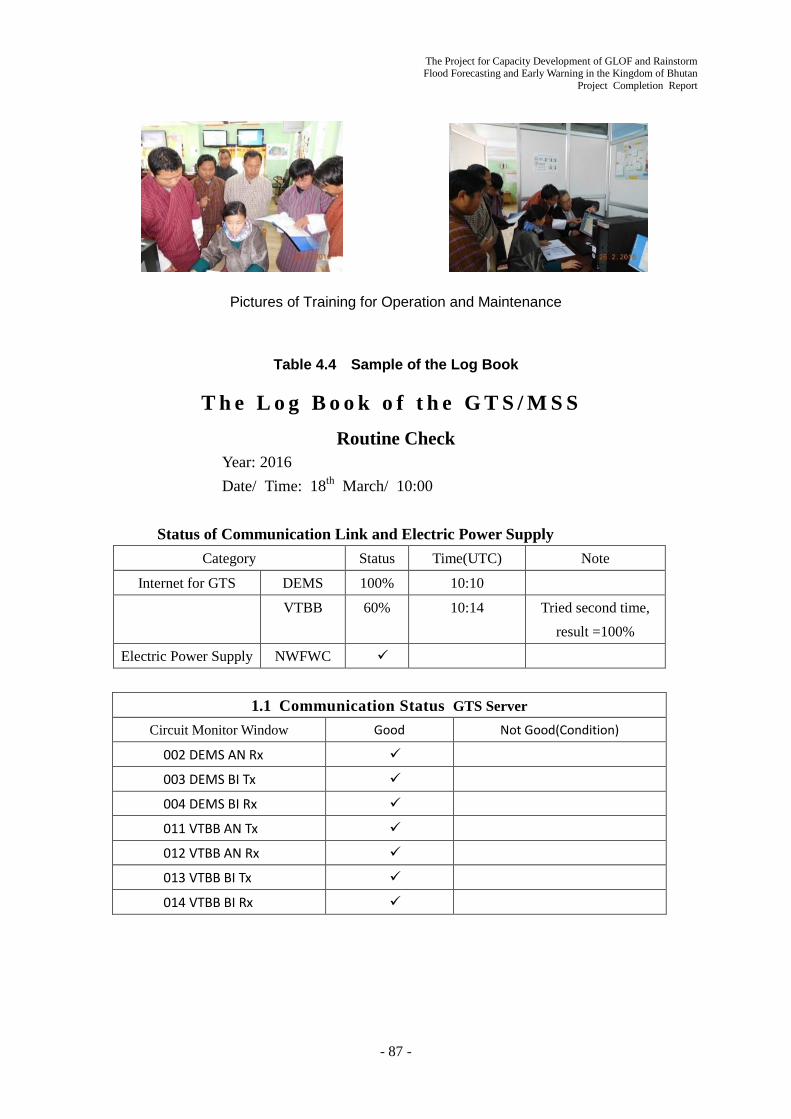
The Project for Capacity Development of GLOF and Rainstorm Flood Forecasting and Early Warning in the Kingdom of Bhutan
Project Completion Report
- 87 -
Pictures of Training for Operation and Maintenance
Table 4.4 Sample of the Log Book
T h e L o g B o o k o f t h e G T S / M S S Routine Check
Year: 2016 Date/ Time: 18th March/ 10:00
Status of Communication Link and Electric Power Supply Category Status Time(UTC) Note
Internet for GTS DEMS 100% 10:10
VTBB 60% 10:14 Tried second time, result =100%
Electric Power Supply NWFWC
1.1 Communication Status GTS Server
Circuit Monitor Window Good Not Good(Condition)
002 DEMS AN Rx
003 DEMS BI Tx
004 DEMS BI Rx
011 VTBB AN Tx
012 VTBB AN Rx
013 VTBB BI Tx
014 VTBB BI Rx

The Project for Capacity Development of GLOF and Rainstorm Flood Forecasting and Early Warning in the Kingdom of Bhutan Project Completion Report
- 88 -
From 14 March to 23 March 2016, the training workshop about the basic operation of GTS/MSS for the forecasters, who were assigned to shift operation, was conducted.
On 24 March, the 24/7 operation procedures of GTS/MSS were explained to the Director General of DHMS. He agreed to conduct 24/7 shift operation of the GTS/MSS. Table 4.5 shows the Shift Duty for the operation.
Table 4.5 The Shift Duty
Shift Duty Duty Hours Personnel
Morning Shift 06:00am-02:00pm A
Afternoon Shift 02:00pm-10:00pm B
Midnight Shift 10:00pm-06:00am C
Off Duty - D
4) Installation of HimawariCast Receiving System
The new Japanese Meteorological Satellite Himawari 8 was launched in October 2014, and has been routinely operated from August 2015. JMA is operating the Satellite Imagery Providing System, which is called the HimawariCast. In March 2016, the HimawariCast Receiving System was installed at NWFWC. The HimawariCast Receiving System passed the inspection on 8 March. The contractor conducted the OJT during the installation with the C/P as participants.
The HimawariCast Receiving System made it possible,
- To make use of 16 channel sensor’s data
- To make use of the Global Image Data, every 10 minutes
- To make use of the SATAID, which is provided by JMA and is applied for weather analysis
- To make use of foreign countries Synoptic Data, Upper Air Data, etc.
Using these data, the Meteorological Expert carried out the Training for forecasters during the period of March, May and June 2016.
The first midnight shift of C/P
TV interview about the new Forecasting System

The Project for Capacity Development of GLOF and Rainstorm Flood Forecasting and Early Warning in the Kingdom of Bhutan
Project Completion Report
- 89 -
Figure 4.2 Example of Finalized Flood Hazard Map
(Bjizam)
Figure 4.1 The Configuration of the HimawariCast Receiving System
4.2.2 Enhancement of Coordination between Risk Assessment Sector and Development Sector (Activity 1-4)
The 5th workshop of Flood Hazard Map Working Group (FHM W/G) was held on March 21, 2016 with 13 members including the new participants from the Department of Roads. The topic was the flood hazard map usage and the role of each agency in the preparation of the hazard map.
In addition to the above, the workshops of MDRR Working Group (MDRR W/G) on the Activity 1-7 (refer to Section 4.2.4) and Activity 1-9 (refer to Section 4.2.6) have also enhanced the future permanent coordination between risk assessment and development sectors.
4.2.3 Preparation and Improvement of Hazard Map through Training (Activity 1-5)
1) Finalization of Flood Hazard Maps
In order to add the evacuation site locations on the flood hazard maps, the JICA experts had visited the communities where the evacuation drills were conducted. The field survey schedule was from 8th to 13th November 2015.
As the result of the field survey for the planned evacuation sites, it became clear that sediment disaster (rock fall / slope failure) dangerous points are located on some of evacuation routes. Therefore, the JICA experts recommended for the community peoples to change the evacuation sites. Hence, some of the sites were shifted. Additionally, the sediment disaster dangerous points were added on the flood hazard maps and noted for vulnerable people to pay attention at the time of evacuation (Figure 4.2)

The Project for Capacity Development of GLOF and Rainstorm Flood Forecasting and Early Warning in the Kingdom of Bhutan Project Completion Report
- 90 -
The finalized flood hazard maps were distributed to the communities and Dzongkhag Disaster Management Officer (DDMO) in August 2016.
2) Trainings on Runoff/Flood Analysis
A training on GIS and runoff analysis was conducted for one FEMD C/P on 19th November 2015. For DHMS C/Ps, a training on runoff and lake breach analysis was held from 23rd to 27th November 2015 at Punatsangchhu EWS Control Room, Wangdue with 8 participants. Furthermore, OJTs to transfer techniques on GLOF simulation and field work were conducted in April and August 2016. As an outcome of transferring techniques, one of the DHMS C/P joined in the training as a lecturer.
Materials prepared for the trainings were revised and compiled as part of the Flood Hazard Map Preparation Manual (Technical Cooperation Output 2).
3) Finalization of Flood Hazard Map Preparation Manual
A draft of Flood Hazard Map Preparation Manual was shared at the 5th FHM W/G workshop held on 21st March 2016. After that, the Manual was revised and finalized in August 2016 and distributed to C/Ps. The Manual has three major contents: 1. Outline of flood risks in Bhutan and expected impacts of flood hazard maps; 2. Flow of flood hazard map preparation and roles of relevant agencies (guidelines); and 3. Practical procedures of runoff/flood analysis (technical part).
4) Trainings and Flood Hazard Map Preparation in Other Basins
A training on runoff/flood analysis was held for 6 FEMD C/Ps from 9th to 11th March 2016. Samdrupjongkhar City, where flood occurred in August 2015, was selected as a target of analysis during the training. After the training, FEMD finalized the flood hazard map in the Samdrupjongkhar City based on the training results (Figure 4.3). FEMD had completed river cross-section survey by themselves before the training and updated the base data for flood analysis. This suggests their technical capacities have been developed. Besides, features of buildings and infrastructures were provided by JICA Project on Establishment of National Geo-Spatial Data Infrastructure for Bhutan.
A training on lake breach and flood analysis was held from 29th March to 1st April 2016. Participants were from DHMS (6), DoES (2), DGM (1) and DoR (1). On the training, a draft flood hazard map for Wangchhu River, Thimphu city was prepared. After the training, DHMS C/P finalized the flood hazard map shown in Figure 4.3.
Picture of Runoff/Flood Analysis

The Project for Capacity Development of GLOF and Rainstorm Flood Forecasting and Early Warning in the Kingdom of Bhutan
Project Completion Report
- 91 -
Figure 4.3 Flood Hazard Maps Prepared by C/Ps Based on Training Results
(Left: Thimphu City, Right: Samdrupjogkhar City)
4.2.4 Institution and Legal System for Mainstreaming Disaster Risk Reduction (Activity 1-7)
On October 26, 2015, it was discussed and agreed with DDM and DHMS that it would be essential to establish the Inter Ministerial Task Force (IMTF) stipulated in the Disaster Management Act 2013 rooted on the Project Working Group as appropriate institution as soon as possible. On October 27, it was agreed with DDM that DDM would proceed with the preparation to gain the approval of the establishment of the IMTF in NDMA to be held in 2016. DDM would prepare the draft TOR of the IMTF and JICA Expert Team would provide the substantive material to DDM.
On February 24, 2016, the 5th workshop of the MDRR W/G was held to discuss the idea of the draft IMTF TOR. A representative from the Department of School Education (DoSE) attended the Workshop as a new W/G member. It was concluded that DDM would prepare the draft IMTF TOR based on the discussion and the W/G members would continue the discussion based on the draft TOR in the next workshop.
On Aug 2, 2016, the 7th workshop of the MDRR W/G was held. DDM presented the draft IMTF TOR prepared. The main points of the draft TOR were 1) several Working Groups of the IMTF would be established based on disaster type as required, since the DM Act 2013 stipulates only one IMTF and 2) the Working Group will review and advice and not to implement practical work like hazard mapping. The W/G members discussed these based on the DDM presentation.
The Minutes of the Meetings are shown in Appendix 11.

The Project for Capacity Development of GLOF and Rainstorm Flood Forecasting and Early Warning in the Kingdom of Bhutan Project Completion Report
- 92 -
4.2.5 Flood and Weather Forecast Utilizing the Numerical Weather Prediction (GPV) (Activity 1-8)
1) Preparation of Training Material and Manual, and Implementation of Training
The draft Training Material for GPV Data Utilization (Technical Cooperation Outputs) was prepared by the JICA Expert in November 2015. Afterwards, the training on the utilization of SATAID and GPV data based on the training material was held in March 2016.
The draft Working Level Manual on Weather and Flood Forecasting (Technical Cooperation Outputs) was prepared by the JICA Expert in November 2015. The training, based on the manual, was implemented for seven (7) counterparts in Meteorology Division (MD), DHMS on 13, 16 and 17 November 2015. Based on the results of the training, the Expert reviewed and modified the draft manual.
The SATAID application with its automatic data acquisition software on the computer used at weather forecasting operation in the MD, was installed by the Expert and displayed the SATAID animation of cloud imagery with GPV data on 25 November 2015. On 27 November 2015,
On 27 November 2015, the Expert inspected the Simtokha Class A (Agricultural) Station in order to gather information which might contribute to the preparation work of the Manual.
Inspection for Class A Station Training on the SATAID with GPV data
The review of the contents and components of the draft Working Level Manual on Weather and Flood Forecasting was done in cooperation with seven (7) C/Ps on 4 December 2015.
On 8 December 2015, a C/P who had been trained in Japan made a presentation on the positive results of the JICA group training course on meteorological capacity building. On the same date, Deputy Director of MD, DHMS made a presentation on the results of the two-month comparison between forecasted values and observed values of weather outlook, maximum temperature and minimum temperature.
In November 2015, the relay of the JMA GPV data in binary form through the GTS/MSS was negotiated with the Regional Telecommunication Hub (RTH)s New Delhi and Bangkok, within the WMO Regional Association II(Asia). C/P had continued negotiations on their relay, under the advice of the Expert until, finally, data started to be received at the DHMS on 8 December 2015.
In March 2016, practical trainings on the effective utilization method of SATAID with GPV data based on the draft Working Level Manual on Weather and Flood Forecasting and the draft Training Material for GPV Data Utilization was conducted. The new HimawariCast System, installed in March, was used in the training. Afterwards, two C/Ps presented the results of the practical training on 28 March 2016.
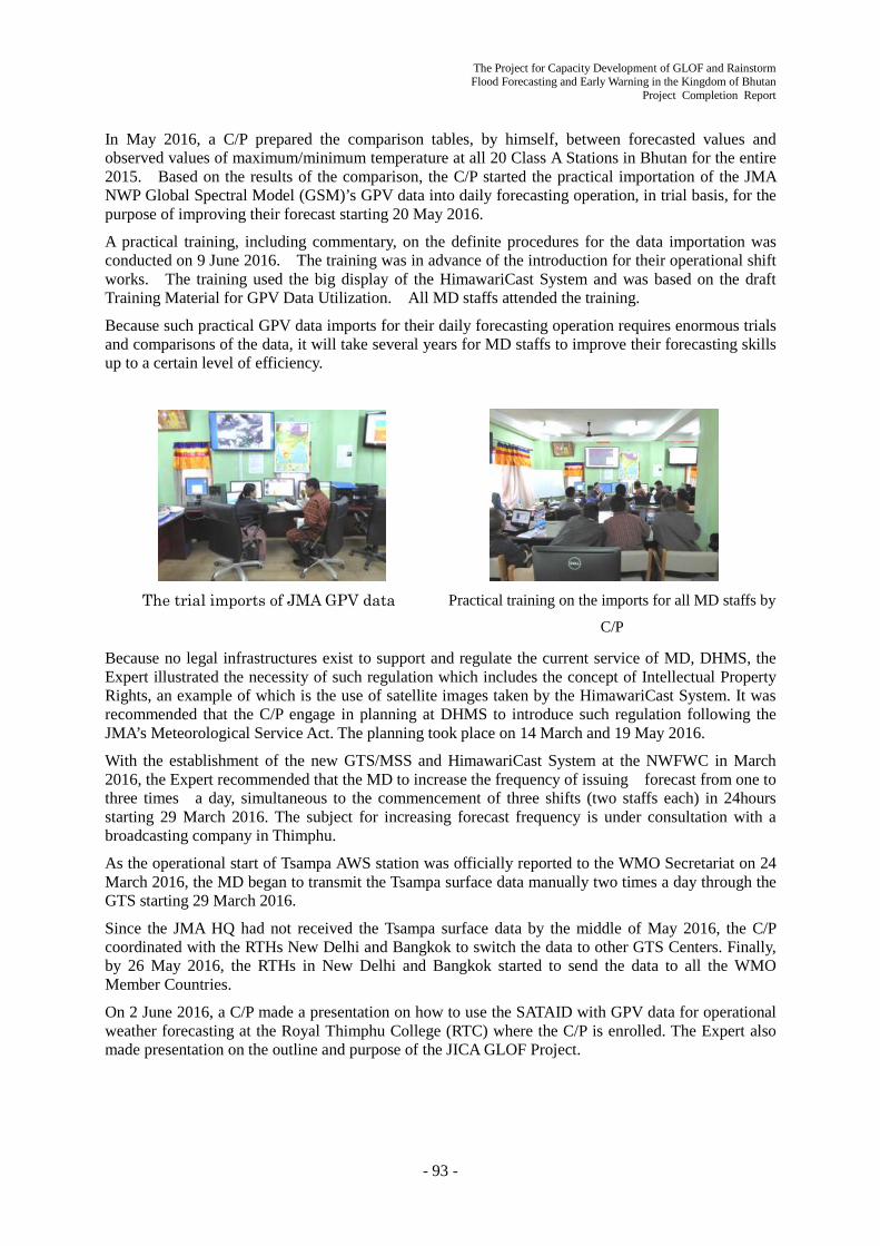
The Project for Capacity Development of GLOF and Rainstorm Flood Forecasting and Early Warning in the Kingdom of Bhutan
Project Completion Report
- 93 -
In May 2016, a C/P prepared the comparison tables, by himself, between forecasted values and observed values of maximum/minimum temperature at all 20 Class A Stations in Bhutan for the entire 2015. Based on the results of the comparison, the C/P started the practical importation of the JMA NWP Global Spectral Model (GSM)’s GPV data into daily forecasting operation, in trial basis, for the purpose of improving their forecast starting 20 May 2016.
A practical training, including commentary, on the definite procedures for the data importation was conducted on 9 June 2016. The training was in advance of the introduction for their operational shift works. The training used the big display of the HimawariCast System and was based on the draft Training Material for GPV Data Utilization. All MD staffs attended the training.
Because such practical GPV data imports for their daily forecasting operation requires enormous trials and comparisons of the data, it will take several years for MD staffs to improve their forecasting skills up to a certain level of efficiency.
The trial imports of JMA GPV data Practical training on the imports for all MD staffs by
C/P
Because no legal infrastructures exist to support and regulate the current service of MD, DHMS, the Expert illustrated the necessity of such regulation which includes the concept of Intellectual Property Rights, an example of which is the use of satellite images taken by the HimawariCast System. It was recommended that the C/P engage in planning at DHMS to introduce such regulation following the JMA’s Meteorological Service Act. The planning took place on 14 March and 19 May 2016.
With the establishment of the new GTS/MSS and HimawariCast System at the NWFWC in March 2016, the Expert recommended that the MD to increase the frequency of issuing forecast from one to three times a day, simultaneous to the commencement of three shifts (two staffs each) in 24hours starting 29 March 2016. The subject for increasing forecast frequency is under consultation with a broadcasting company in Thimphu.
As the operational start of Tsampa AWS station was officially reported to the WMO Secretariat on 24 March 2016, the MD began to transmit the Tsampa surface data manually two times a day through the GTS starting 29 March 2016.
Since the JMA HQ had not received the Tsampa surface data by the middle of May 2016, the C/P coordinated with the RTHs New Delhi and Bangkok to switch the data to other GTS Centers. Finally, by 26 May 2016, the RTHs in New Delhi and Bangkok started to send the data to all the WMO Member Countries.
On 2 June 2016, a C/P made a presentation on how to use the SATAID with GPV data for operational weather forecasting at the Royal Thimphu College (RTC) where the C/P is enrolled. The Expert also made presentation on the outline and purpose of the JICA GLOF Project.
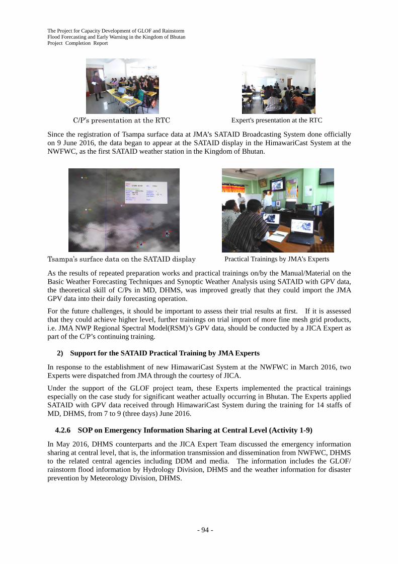
The Project for Capacity Development of GLOF and Rainstorm Flood Forecasting and Early Warning in the Kingdom of Bhutan Project Completion Report
- 94 -
C/P’s presentation at the RTC Expert's presentation at the RTC
Since the registration of Tsampa surface data at JMA’s SATAID Broadcasting System done officially on 9 June 2016, the data began to appear at the SATAID display in the HimawariCast System at the NWFWC, as the first SATAID weather station in the Kingdom of Bhutan.
Tsampa’s surface data on the SATAID display Practical Trainings by JMA’s Experts
As the results of repeated preparation works and practical trainings on/by the Manual/Material on the Basic Weather Forecasting Techniques and Synoptic Weather Analysis using SATAID with GPV data, the theoretical skill of C/Ps in MD, DHMS, was improved greatly that they could import the JMA GPV data into their daily forecasting operation.
For the future challenges, it should be important to assess their trial results at first. If it is assessed that they could achieve higher level, further trainings on trial import of more fine mesh grid products, i.e. JMA NWP Regional Spectral Model(RSM)’s GPV data, should be conducted by a JICA Expert as part of the C/P’s continuing training.
2) Support for the SATAID Practical Training by JMA Experts
In response to the establishment of new HimawariCast System at the NWFWC in March 2016, two Experts were dispatched from JMA through the courtesy of JICA.
Under the support of the GLOF project team, these Experts implemented the practical trainings especially on the case study for significant weather actually occurring in Bhutan. The Experts applied SATAID with GPV data received through HimawariCast System during the training for 14 staffs of MD, DHMS, from 7 to 9 (three days) June 2016.
4.2.6 SOP on Emergency Information Sharing at Central Level (Activity 1-9)
In May 2016, DHMS counterparts and the JICA Expert Team discussed the emergency information sharing at central level, that is, the information transmission and dissemination from NWFWC, DHMS to the related central agencies including DDM and media. The information includes the GLOF/ rainstorm flood information by Hydrology Division, DHMS and the weather information for disaster prevention by Meteorology Division, DHMS.
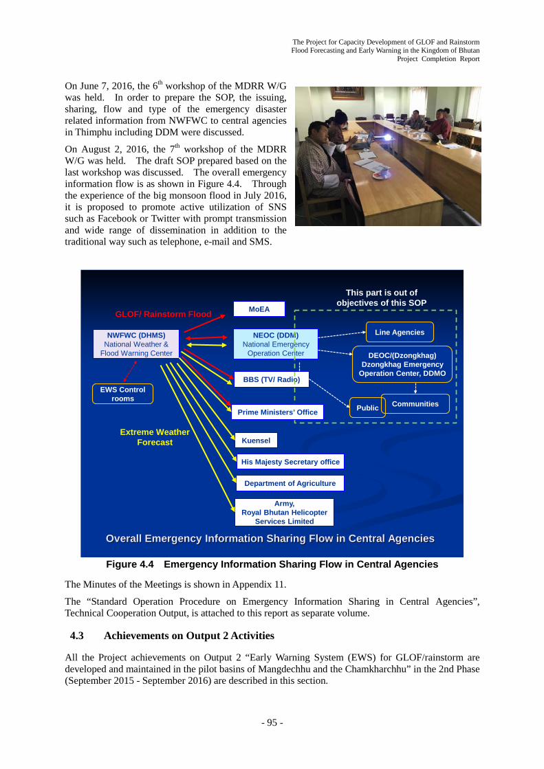
The Project for Capacity Development of GLOF and Rainstorm Flood Forecasting and Early Warning in the Kingdom of Bhutan
Project Completion Report
- 95 -
On June 7, 2016, the 6th workshop of the MDRR W/G was held. In order to prepare the SOP, the issuing, sharing, flow and type of the emergency disaster related information from NWFWC to central agencies in Thimphu including DDM were discussed.
On August 2, 2016, the 7th workshop of the MDRR W/G was held. The draft SOP prepared based on the last workshop was discussed. The overall emergency information flow is as shown in Figure 4.4. Through the experience of the big monsoon flood in July 2016, it is proposed to promote active utilization of SNS such as Facebook or Twitter with prompt transmission and wide range of dissemination in addition to the traditional way such as telephone, e-mail and SMS.
Line AgenciesNWFWC (DHMS)National Weather &
Flood Warning Center
NEOC (DDM)National Emergency
Operation Center
MoEA
BBS (TV/ Radio)
Kuensel
His Majesty Secretary office
Department of Agriculture
Army, Royal Bhutan Helicopter
Services Limited
DEOC/(Dzongkhag)Dzongkhag Emergency
Operation Center, DDMO
CommunitiesPublic
EWS Control rooms
Extreme Weather Forecast
GLOF/ Rainstorm Flood
This part is out of objectives of this SOP
Overall Emergency Information Sharing Flow in Central Agencies
Prime Ministers’ Office
Figure 4.4 Emergency Information Sharing Flow in Central Agencies
The Minutes of the Meetings is shown in Appendix 11.
The “Standard Operation Procedure on Emergency Information Sharing in Central Agencies”, Technical Cooperation Output, is attached to this report as separate volume.
4.3 Achievements on Output 2 Activities
All the Project achievements on Output 2 “Early Warning System (EWS) for GLOF/rainstorm are developed and maintained in the pilot basins of Mangdechhu and the Chamkharchhu” in the 2nd Phase (September 2015 - September 2016) are described in this section.

The Project for Capacity Development of GLOF and Rainstorm Flood Forecasting and Early Warning in the Kingdom of Bhutan Project Completion Report
- 96 -
4.3.1 Installation of EWS Equipment in the Pilot Basins (Activity 2-4)
1) Supporting Installation of Equipment and Final Inspection
The JICA Expert Team assisted the interim inspection from October 5 to 13, 2015 for the EWS equipment installed along Mangdechhu and Chamkharchhu basins by the JICA Contractor (Helicom Corporation Inc.) from September to October 2015. It was confirmed that the EWS started to operate as a whole. Accordingly, the Team and the C/P started the preparation of the EWS Operation and Maintenance (O & M) Manual and the O & M trainings using the EWS in operation since October 14, 2015.
The JICA Expert Team and DHMS assisted the remaining installation work conducted by the JICA Contractor from February 24 to March 15, 2016. The Team and DHMS assisted the final inspection on March 16, 2016 and it was confirmed that all the EWS equipment installed passed the inspection.
What is notable is that DHMS dispatched many staff to the Pilot Project Areas for around 4 months (September to October 2015 and February to March 2016), at its own expense, to assist the EWS installation work by the JICA Contractor with the cooperation of the JICA Expert Team.
After that, the EWS has been in full working order. Therefore, the DHMS started 24/7 EWS operation by May 5, 2016.
The JICA Expert Team and DHMS assisted the field service maintenance work for the EWS conducted by the JICA Contractor from May 25 to June 3, 2016.
2) Installation of Backup Power Generator for EWS
Although the installed EWS are equipped by Uninterruptible Power supply Systems (UPS) for safety shutdown and restart of the system, it cannot secure the continuous operation during power failure. In order to secure backup power in emergency, three (3) diesel power generators with AMF panels were procured and installed into the NWFWC in Thimphu and the Control Centers in the basins. The operation and maintenance of the generators were instructed in the EWS O/M manual indicated in the Section 0.
3) Revision of Alert/Alarm Levels of EWS
The initial Alert/Alarm levels of EWS were set based on the past manual observation records of river water levels and flood marks (refer to Section 3.3.4). After the EWS operation started, water levels at all stations have been continuously recorded including the flood on 26th July 2016 which was caused by continuous rainfall in the monsoon period. Then, it was judged that enough water level records to revise the initial Alert/Alarm levels were obtained. Table 4.6 shows the revised Alert/Alarm levels at all AWLS. The Alert levels which had been initially set as safer value were increased based on the observed water level in the monsoon period 2016. In contrast, the Alarm levels were decreased or increased depending on the characteristics of each AWLS considering high water level marks of the flood on 26th July 2016. The Alert/Alarm levels should be revised continuously depending on the accumulation of observed water level data and change of river bed condition.
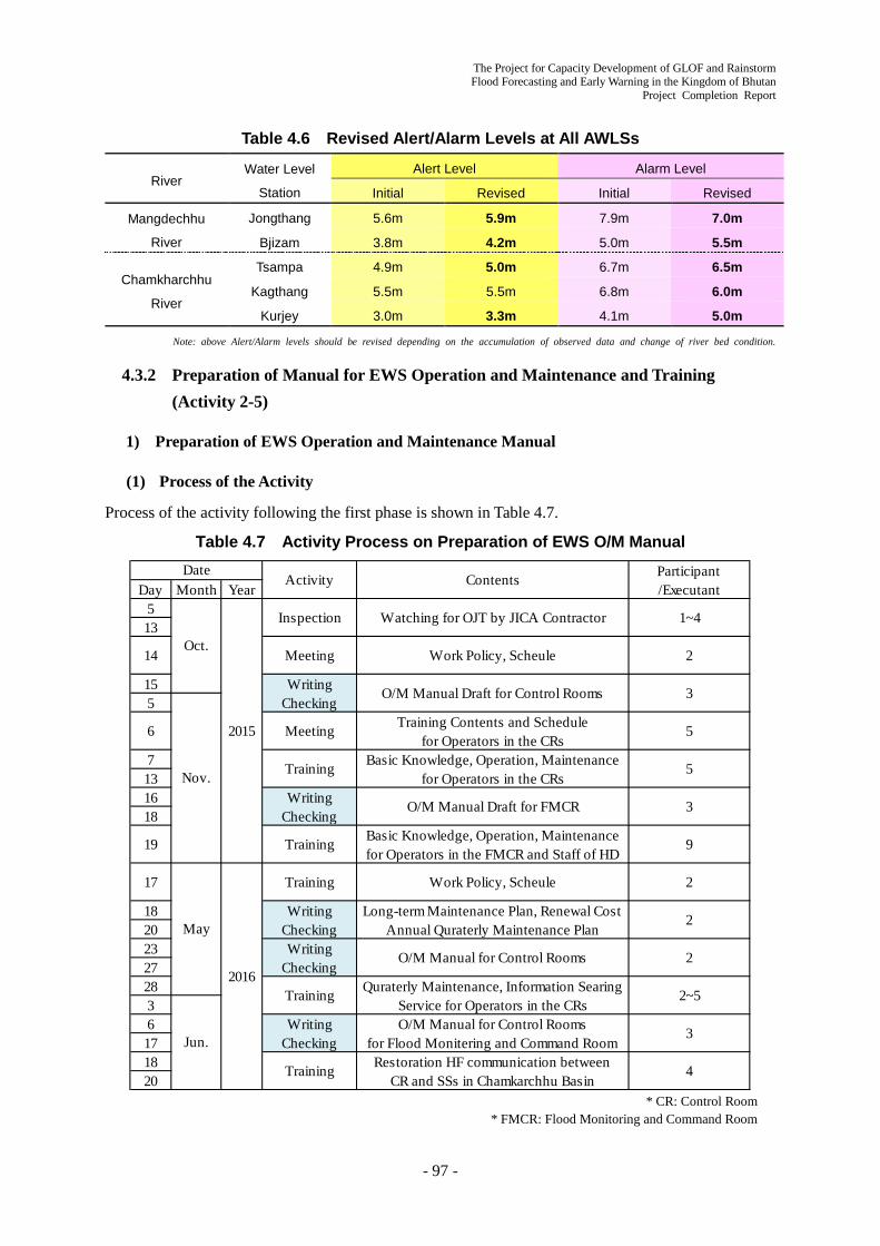
The Project for Capacity Development of GLOF and Rainstorm Flood Forecasting and Early Warning in the Kingdom of Bhutan
Project Completion Report
- 97 -
Table 4.6 Revised Alert/Alarm Levels at All AWLSs
River Water Level
Station
Alert Level Alarm Level
Initial Revised Initial Revised
Mangdechhu
River
Jongthang 5.6m 5.9m 7.9m 7.0m
Bjizam 3.8m 4.2m 5.0m 5.5m
Chamkharchhu
River
Tsampa 4.9m 5.0m 6.7m 6.5m
Kagthang 5.5m 5.5m 6.8m 6.0m
Kurjey 3.0m 3.3m 4.1m 5.0m
Note: above Alert/Alarm levels should be revised depending on the accumulation of observed data and change of river bed condition.
4.3.2 Preparation of Manual for EWS Operation and Maintenance and Training (Activity 2-5)
1) Preparation of EWS Operation and Maintenance Manual
(1) Process of the Activity
Process of the activity following the first phase is shown in Table 4.7.
Table 4.7 Activity Process on Preparation of EWS O/M Manual
* CR: Control Room
* FMCR: Flood Monitoring and Command Room
Day Month Year513
155
7131618
182023272836171820
2~5
Jun.Writing
CheckingO/M Manual for Control Rooms
for Flood Monitering and Command Room3
Training Restoration HF communication betweenCR and SSs in Chamkarchhu Basin
4
2
WritingChecking
Long-term Maintenance Plan, Renewal CostAnnual Quraterly Maintenance Plan
2
WritingChecking
O/M Manual for Control Rooms 2
3
19 Training Basic Knowledge, Operation, Maintenancefor Operators in the FMCR and Staff of HD
9
Nov.
6 Meeting Training Contents and Schedulefor Operators in the CRs
5
Training Basic Knowledge, Operation, Maintenancefor Operators in the CRs
5
WritingChecking
O/M Manual Draft for FMCR
17
May
2016
Training Work Policy, Scheule
Training Quraterly Maintenance, Information SearingService for Operators in the CRs
DateActivity Contents Participant
/Executant
Oct.
2015
Inspection Watching for OJT by JICA Contractor 1~4
14 Meeting Work Policy, Scheule 2
WritingChecking
O/M Manual Draft for Control Rooms 3

The Project for Capacity Development of GLOF and Rainstorm Flood Forecasting and Early Warning in the Kingdom of Bhutan Project Completion Report
- 98 -
In October 2015 a part of the second phase, DHMS staff could touch and operate the EWS actually because the JICA Contractor almost finished installation and regulation works at the time. The final versions of the operation manuals for the system software were submitted by the Contractor. After that the activity team integrated them into the O/M Manual and completed the draft version in October and November. DHMS operators in both control rooms were trained using the draft O/M Manual as the EWS started provisional operation.
In February and March 2016 the JICA Contractor had solved the remaining problem encountered in October 2015 and passed the completion inspection. On another front, the development of the SOP for GLOF/rainstorm flood in pilot basins (Activity 3-4) proceeded. Contents of information sharing service under flood condition were finalized while installation works of engine generator to ensure continuous operation during power failure were implemented. In June 2016 the activity team used these developments and included into the O/M Manual, thus completing the final version.
(2) Title of the Manuals
The Manuals were prepared as three (3) separate volumes for both control rooms and for the flood monitoring/command room in NWFWC in DHMS. Titles of the manuals are as below.
- OPERATION AND MAINTENANCE MANUAL FOR THE GLOF AND RAINSTORM FLOOD EARLY WARNING SYSTEM (FEWS) THE MANGDECHHU BASIN FEWS
- OPERATION AND MAINTENANCE MANUAL FOR THE GLOF AND RAINSTORM FLOOD EARLY WARNING SYSTEM (FEWS) THE CHAMKHARCHHU BASIN FEWS
- OPERATION AND MAINTENANCE MANUAL FOR THE GLOF AND RAINSTORM FLOOD EARLY WARNING SYSTEMS (FEWS) IN MANGDECHHU AND CHAMKHARCHHU BASINS THE FLOOD MONITORING AND COMMAND ROOM IN NWFWC
(3) Contents of the O/M Manual
The Contents of OPERATION AND MAINTENANCE MANUAL FOR THE GLOF AND RAINSTORM FLOOD EARLY WARNING SYSTEM (FEWS) THE MANGDECHHU BASIN FEWS are shown in Table 4.8. The other two (2) volumes have the same contents except the sections where the information unique to the basins and systems is replaced.

The Project for Capacity Development of GLOF and Rainstorm Flood Forecasting and Early Warning in the Kingdom of Bhutan
Project Completion Report
- 99 -
Table 4.8 Contents of EWS O/M Manual
Remark1.1 What is this Book1.2 Scope of this Book2.1 Flood2.2 Flood Countermeasure2.3 Flood Early Warning System (FEWS)3.1 Outline3.2 Glacial Lakes3.3 Probable Flood Discharge3.4 Flood Arrival Time3.5 Flood Prone Areas3.6 Dam and Power Plant4.1 Whole System4.2 Flood Early Warning System (FEWS)4.3 Main Communication System4.4 Sub Communication System4.5 Equipment of Each Station5.1 Graphic-user-interface5.2 The Operation Screen5.3 The Monitoring Screen5.4 The Controller for the AWLSs5.5 The Controller for the SSs
5.6 Radio Communicaton with the FMCR and with the Dzong
6.1 Warning Process6.2 In Case of GLOF6.3 in Case of RSF6.4 Information Sharing6.5 Manual Siren Activation6.6 False Alarm7.1 Type of Maintenance and Unit in charge7.2 Daily Check7.3 Quarterly Maintenance7.4 Repair Work7.5 Spare Parts7.6 Consumable Supplies7.7 Tools and Equipment7.8 Engine Generator8.1 Principle8.2 Setup the Value8.3 Threshold Water Levels at Jongthang AWLS8.4 Threshold Water Levels at Bjizam AWLS9.1 General9.2 Shiftwork9.3 Duties of the Operators1 Data Transmission Scheme2 Desiccant Replacement of the Bubble Gauge3 Example of Yearly Maintenance Plan4 Manual Siren Activation Test
Appendix
Preparationin 1st Phase
Preparationin 1st Phase
Preparationin 1st Phase
Preparationin 2nd Phase
Preparationin 2nd Phase
Preparationin 1st PhaseAmendmentin 2nd Phase
Preparationin 1st PhaseAmendmentin 2nd Phase
Preparationin 2nd Phase
7 Maintenance Service
8 Thereshold Water levels at the AWLSs
Preparationin 1st Phase
9 The Operators Preparationin 2nd Phase
4 The System
5 Operation of the System
6 Warning Service
OPERATION AND MAINTENANCE MANUAL FOR THE GLOF AND RAINSTORM FLOOD EARLYWARNING SYSTEM (FEWS)
THE MANGDECHHU BASIN FEWS JUNE 2016Chapter Section
1 Introduction
2 Basic Knowledge
3 Characteristics ofthe Mangdechhu Basin
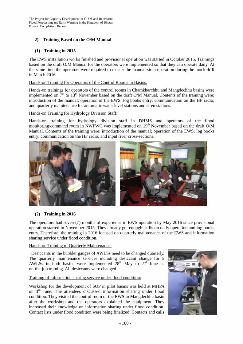
The Project for Capacity Development of GLOF and Rainstorm Flood Forecasting and Early Warning in the Kingdom of Bhutan Project Completion Report
- 100 -
2) Training Based on the O/M Manual
(1) Training in 2015
The EWS installation works finished and provisional operation was started in October 2015. Trainings based on the draft O/M Manual for the operators were implemented so that they can operate daily. At the same time the operators were required to master the manual siren operation during the mock drill in March 2016.
Hands-on Training for Operators of the Control Rooms in Basins:
Hands-on trainings for operators of the control rooms in Chamkharchhu and Mangdechhu basins were implemented on 7th to 13th November based on the draft O/M Manual. Contents of the training were: introduction of the manual; operation of the EWS; log books entry; communication on the HF radio; and quarterly maintenance for automatic water level stations and siren stations.
Hands-on Training for Hydrology Division Staff:
Hands-on training for hydrology division staff in DHMS and operators of the flood monitoring/command room in NWFWC was implemented on 19th November based on the draft O/M Manual. Contents of the training were: introduction of the manual; operation of the EWS; log books entry; communication on the HF radio; and input river cross-sections.
(2) Training in 2016
The operators had seven (7) months of experience in EWS operation by May 2016 since provisional operation started in November 2015. They already got enough skills on daily operation and log books entry. Therefore, the training in 2016 focused on quarterly maintenance of the EWS and information sharing service under flood condition.
Hands-on Training of Quarterly Maintenance:
Desiccants in the bubbler gauges of AWLSs need to be changed quarterly. The quarterly maintenance services including desiccant change for 5 AWLSs in both basins were implemented 28th May to 2nd June as on-the-job training. All desiccants were changed.
Training of information sharing service under flood condition:
Workshop for the development of SOP in pilot basins was held at MHPA on 3rd June. The attendees discussed information sharing under flood condition. They visited the control room of the EWS in Mangdechhu basin after the workshop and the operators explained the equipment. They increased their knowledge on information sharing under flood condition. Contact lists under flood condition were being finalized. Contacts and calls

The Project for Capacity Development of GLOF and Rainstorm Flood Forecasting and Early Warning in the Kingdom of Bhutan
Project Completion Report
- 101 -
on drill under flood condition will be implemented using finalized contact lists.
Recovery Work on HF Communication:
The HF communication of the EWS was down on 11th June in Chamkharchhu basin. Improper operation of the HF transceivers seemed to be the cause of the malfunction. Communication between the control room and the automatic water level stations recovered after a while but communication between the control room and the siren stations had been out of order. Two of hydrology division staff with the JICA expert succeeded recovery work on 19th June as part of on-the-job training.
3) Long-term Maintenance for the EWS
The key point for long-term sustainability of the EWS is an ensured renewal budget for electronic equipment which generally has short life time. The activity team estimated electronic equipment renewal cost for 30 years. The total cost was estimated as 93 million BTN. DHMS was aware of the importance of ensuring the budget in a planned and steady way.
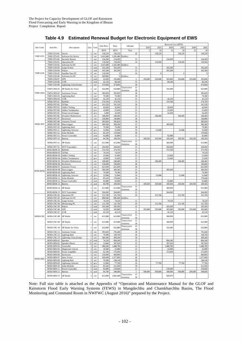
The Project for Capacity Development of GLOF and Rainstorm Flood Forecasting and Early Warning in the Kingdom of Bhutan Project Completion Report
- 102 -
Table 4.9 Estimated Renewal Budget for Electronic Equipment of EWS
Note: Full size table is attached as the Appendix of “Operation and Maintenance Manual for the GLOF and Rainstorm Flood Early Warning Systems (FEWS) in Mangdechhu and Chamkharchhu Basins, The Flood Monitoring and Command Room in NWFWC (August 2016)” prepared by the Project.
2020 2025 2030 2035 2040 2045BTN BTN 5 10 15 20 25 30
TMP-GTS-04 Server 1 set 158,220 158,220 10 158,220 158,220 158,220TMP-GTS-05 Software for Server 1 set 3,165,480 3,165,480 EndlessTMP-GTS-06 Security Router 1 set 124,200 124,200 15 124,200 124,200TMP-COS-01 Operation PC 1 set 118,260 118,260 10 118,260 118,260 118,260TMP-COS-02 Software for PC 1 set 3,165,480 3,165,480 EndlessTMP-COS-03 Large Screen 1 unit 165,240 165,240 15 165,240 165,240TMP-COS-04 Printer 1 unit 105,300 105,300 15 105,300 105,300TMP-COS-05 Satellite Data PC 0 set 118,260 0 10 0 0 0TMP-COS-06 Software for PC 0 set 949,860 0 EndlessTMP-COS-07 UPS 2 unit 52,920 105,840 5 105,840 105,840 105,840 105,840 105,840 105,840TMP-COS-08 AVR 2 unit 42,120 84,240 15 84,240 84,240TMP-COS-09 Lightning Transformer 1 set 474,660 474,660 30 474,660
TMP-CMS-01 HF Radio for Voice 1 set 632,880 632,880 TransceiverAntenna
1530
316,440 632,880
TMP-CMS-02 Antennea Tower 1 set 395,820 395,820 30 395,820TMP-CMS-03 Lightning Rod 1 set 79,380 79,380 30 79,380TMP-CMS-04 AVR 1 unit 42,120 42,120 15 42,120 42,120MND-JNT-01 Bubbler 1 set 374,760 374,760 15 374,760 374,760MND-JNT-02 GI Pipe 1 set 101,520 101,520 30 101,520MND-JNT-03 Orifice Tubing 1 set 42,660 42,660 15 42,660 42,660MND-JNT-04 Orifice Termination 2 pcs 10,800 21,600 15 21,600 21,600MND-JNT-05 Water Level Gauge 3 pcs 5,400 16,200 15 16,200 16,200MND-JNT-06 Weather Multisensor 1 set 248,400 248,400 10 248,400 248,400 248,400MND-JNT-07 Enclosure 1 set 146,880 146,880 30 146,880MND-JNT-08 Antenne Tower 1 set 395,820 395,820 30 395,820MND-JNT-09 Data Logger 1 set 369,360 369,360 15 369,360 369,360MND-JNT-10 Lightning Rod 1 set 79,380 79,380 30 79,380MND-JNT-11 Lightning Arrester 4 pcs 12,960 51,840 10 51,840 51,840 51,840MND-JNT-12 Solar Module 2 pcs 85,320 170,640 30 170,640MND-JNT-13 Power Controller 1 unit 92,880 92,880 15 92,880 92,880MND-JNT-14 Battery 2 unit 84,780 169,560 5 169,560 169,560 169,560 169,560 169,560 169,560
MND-JNT-15 HF Radio 1 set 613,980 613,980 TransceiverAntenna
1530
306,990 613,980
MND-JNT-16 DCP Transmitter 1 set 264,060 264,060 15 264,060 264,060MND-BZM-01 Bubbler 1 set 374,760 374,760 15 374,760 374,760MND-BZM-02 GI Pipe 1 set 74,520 74,520 30 74,520MND-BZM-03 Orifice Tubing 1 set 21,060 21,060 15 21,060 21,060MND-BZM-04 Orifice Termination 2 pcs 10,800 21,600 15 21,600 21,600MND-BZM-05 Weather Multisensor 1 set 248,400 248,400 10 248,400 248,400 248,400MND-BZM-06 Enclosure 1 set 156,600 156,600 30 156,600MND-BZM-07 Antenne Tower 1 set 621,000 621,000 30 621,000MND-BZM-08 Data Logger 1 set 369,360 369,360 15 369,360 369,360MND-BZM-09 Lightning Rod 1 set 79,380 79,380 30 79,380MND-BZM-10 Lightning Arrester 4 pcs 12,960 51,840 10 51,840 51,840 51,840MND-BZM-11 Solar Module 2 pcs 85,320 170,640 30 170,640MND-BZM-12 Power Controller 1 unit 92,880 92,880 15 92,880 92,880MND-BZM-13 Battery 2 unit 84,780 169,560 5 169,560 169,560 169,560 169,560 169,560 169,560
MND-BZM-14 HF Radio 1 set 613,980 613,980 TransceiverAntenna
1530
306,990 613,980
MND-BZM-15 DCP Transmitter 1 set 264,060 264,060 15 264,060 264,060MND-CNC-01 Operation PC 1 set 131,760 131,760 10 131,760 131,760 131,760MND-CNC-02 Software for PC 1 set 896,940 896,940 EndlessMND-CNC-03 Large Screen 1 unit 74,520 74,520 15 74,520 74,520MND-CNC-04 Monitoring PC 1 set 131,760 131,760 10 131,760 131,760 131,760MND-CNC-05 Printer 1 unit 105,300 105,300 15 105,300 105,300MND-CNC-06 UPS 2 unit 52,920 105,840 5 105,840 105,840 105,840 105,840 105,840 105,840MND-CNC-07 AVR 1 unit 42,120 42,120 15 42,120 42,120
MND-CNC-08 HF Radio 1 set 613,980 613,980 TransceiverAntenna
1530
306,990 613,980
MND-CNC-09 HF Radio 1 set 613,980 613,980 TransceiverAntenna
1530
306,990 613,980
MND-CNC-10 HF Radio for Voice 1 set 632,880 632,880 TransceiverAntenna
1530
316,440 632,880
MND-CNC-11 Antenne Tower 2 set 395,820 791,640 30 791,640MND-CNC-12 Lightnig Rod 2 set 79,380 158,760 30 158,760MND-CNC-13 Lightning Transformer 1 set 369,360 369,360 30 369,360MND-SRN-01 Speaker 12 unit 74,520 894,240 15 894,240 894,240MND-SRN-02 Speaker Driver 12 set 15,660 187,920 15 187,920 187,920MND-SRN-03 Controller 3 set 496,260 1,488,780 15 1,488,780 1,488,780MND-SRN-04 Diagnostic Circuit 3 set 18,360 55,080 15 55,080 55,080MND-SRN-05 Power Amplifier 6 unit 62,100 372,600 15 372,600 372,600MND-SRN-06 Enclosure 3 set 156,600 469,800 30 469,800MND-SRN-07 Siren Tower 3 set 459,000 1,377,000 30 1,377,000MND-SRN-08 Lightnig Rod 3 set 79,380 238,140 30 238,140MND-SRN-09 Lightning Arrester 6 pcs 12,960 77,760 10 77,760 77,760 77,760MND-SRN-10 Solar Module 6 pcs 85,320 511,920 30 511,920MND-SRN-11 Power Controller 3 unit 92,880 278,640 15 278,640 278,640MND-SRN-12 Battery 6 unit 84,780 508,680 5 508,680 508,680 508,680 508,680 508,680 508,680
MND-SRN-13 HF Radio 3 set 613,980 1,841,940 TransceiverAntenna
1530
920,970
MND-CNC
MND-SRN
Price LifetimeRenewal Cost (BTN)
Year
TMP-GTS
TMP-COS
Site Code Item No. Description Q'ty UnitUnit Price
TMP-CMS
MND-JNT
MND-BZM

The Project for Capacity Development of GLOF and Rainstorm Flood Forecasting and Early Warning in the Kingdom of Bhutan
Project Completion Report
- 103 -
CHM-TSM-A-01 Anemometer Sensor 1 set 131,760 131,760 Out of coverageCHM-TSM-A-02 Thermometer / Hygrometer 1 set 124,200 124,200 Out of coverageCHM-TSM-A-03 Barometer 1 set 104,220 104,220 Out of coverageCHM-TSM-A-04 Pyranometer 1 set 211,140 211,140 Out of coverageCHM-TSM-A-05 Weight Type Rain Gauge 1 set 597,780 597,780 Out of coverageCHM-TSM-A-06 Tipping Bucket Rain Gauge 1 set 64,260 64,260 15 64,260 64,260CHM-TSM-A-07 Enclosure 1 set 156,600 156,600 30 156,600CHM-TSM-A-08 Antenne Tower 1 set 395,820 395,820 30 395,820CHM-TSM-A-09 Data Logger 1 set 369,360 369,360 15 369,360 369,360CHM-TSM-A-10 Lightning Rod 1 set 79,380 79,380 30 79,380CHM-TSM-A-11 Lightning Arrester 3 pcs 12,960 38,880 10 38,880 38,880 38,880CHM-TSM-A-12 Solar Module 2 unit 85,320 170,640 30 170,640CHM-TSM-A-13 Power Controller 1 unit 92,880 92,880 15 92,880 92,880CHM-TSM-A-14 Battery 2 unit 84,780 169,560 5 169,560 169,560 169,560 169,560 169,560 169,560
CHM-TSM-A-15 HF Radio 1 set 613,980 613,980 TransceiverAntenna
1530
306,990 613,980
CHM-TSM-A-16 DCP Transmitter 1 set 264,060 264,060 15 264,060 264,060
CHM-TSM-A-17 UHF Radio 1 set 342,900 342,900 TransceiverAntenna
1530
171,450 342,900
CHM-TSM-B-01 Bubbler with Temp Sensor 1 set 378,000 378,000 15 378,000 378,000CHM-TSM-B-02 GI Pipe 1 set 68,040 68,040 30 68,040CHM-TSM-B-03 Orifice Tubing 1 set 21,060 21,060 15 21,060 21,060CHM-TSM-B-04 Orifice Termination 2 pcs 10,800 21,600 15 21,600 21,600CHM-TSM-B-05 Water Level Gauge 3 pcs 5,400 16,200 15 16,200 16,200CHM-TSM-B-06 Tower B 1 set 65,340 65,340 30 65,340CHM-TSM-B-07 Enclosure 1 set 156,600 156,600 30 156,600CHM-TSM-B-08 Data Logger 1 set 369,360 369,360 15 369,360 369,360CHM-TSM-B-09 Lightning Rod 1 set 63,180 63,180 30 63,180CHM-TSM-B-10 Lightning Arrester 3 pcs 12,960 38,880 10 38,880 38,880 38,880CHM-TSM-B-11 Solar Module 1 unit 85,320 85,320 30 85,320CHM-TSM-B-12 Power Controller 1 unit 92,880 92,880 15 92,880 92,880CHM-TSM-B-13 Battery 1 unit 84,780 84,780 5 84,780 84,780 84,780 84,780 84,780 84,780
CHM-TSM-B-14 UHF Radio 1 set 342,900 342,900 TransceiverAntenna
1530
171,450 342,900
CHM-KGT-01 Bubbler 1 set 374,760 374,760 15 374,760 374,760CHM-KGT-02 GI Pipe 1 set 86,940 86,940 30 86,940CHM-KGT-03 Orifice Tubing 1 set 31,860 31,860 15 31,860 31,860CHM-KGT-04 Orifice Termination 2 pcs 10,800 21,600 15 21,600 21,600CHM-KGT-05 Water Level Gauge 3 pcs 5,400 16,200 15 16,200 16,200CHM-KGT-06 Weather Multisensor 1 set 248,400 248,400 10 248,400 248,400 248,400CHM-KGT-07 Enclosure 1 set 156,600 156,600 30 156,600CHM-KGT-08 Antenne Tower 1 set 395,820 395,820 30 395,820CHM-KGT-09 Data Logger 1 set 369,360 369,360 15 369,360 369,360CHM-KGT-10 Lightning Rod 1 set 79,380 79,380 30 79,380CHM-KGT-11 Lightning Arrester 4 pcs 12,960 51,840 10 51,840 51,840 51,840CHM-KGT-12 Solar Module 2 pcs 85,320 170,640 30 170,640CHM-KGT-13 Power Controller 1 unit 92,880 92,880 15 92,880 92,880CHM-KGT-14 Battery 2 unit 84,780 169,560 5 169,560 169,560 169,560 169,560 169,560 169,560
CHM-KGT-15 HF Radio 1 set 613,980 613,980 TransceiverAntenna
1530
306,990 613,980
CHM-KGT-16 DCP Transmitter 1 set 264,060 264,060 15 264,060 264,060CHM-KJY-A-01 Bubbler 1 set 374,760 374,760 15 374,760 374,760CHM-KJY-A-02 GI Pipe 1 set 130,140 130,140 30 130,140CHM-KJY-A-03 Orifice Tubing 1 set 21,060 21,060 15 21,060 21,060CHM-KJY-A-04 Orifice Termination 2 pcs 10,800 21,600 15 21,600 21,600CHM-KJY-A-05 Enclosure 1 set 156,600 156,600 30 156,600CHM-KJY-A-06 Data Logger 1 set 369,360 369,360 15 369,360 369,360CHM-KJY-A-07 Lightning Arrester 0 pcs 12,960 0 10 0 0 0
CHM-KJY-A-08 UHF Radio 1 set 342,900 342,900 TransceiverAntenna
1530
171,450 342,900
CHM-KJY-B-01 Weather Multisensor 1 set 248,400 248,400 10 248,400 248,400 248,400CHM-KJY-B-02 Enclosure 1 set 156,600 156,600 30 156,600CHM-KJY-B-03 Antenne Tower 1 set 395,820 395,820 30 395,820CHM-KJY-B-04 Data Logger 1 set 369,360 369,360 15 369,360 369,360CHM-KJY-B-05 Lightning Rod 1 set 92,880 92,880 30 92,880CHM-KJY-B-06 Lightning Arrester 4 pcs 12,960 51,840 10 51,840 51,840 51,840CHM-KJY-B-07 Solar Module 2 pcs 85,320 170,640 30 170,640CHM-KJY-B-08 Power Controller 1 unit 92,880 92,880 15 92,880 92,880CHM-KJY-B-09 Battery 2 unit 84,780 169,560 5 169,560 169,560 169,560 169,560 169,560 169,560CHM-KJY-B-10 DCP Transmitter 1 set 264,060 264,060 15 264,060 264,060
CHM-KJY-B-11 UHF Radio 1 set 342,900 342,900 TransceiverAntenna
1530
171,450 342,900
CHM-CNC-01 Operation PC 1 set 131,760 131,760 10 131,760 131,760 131,760CHM-CNC-02 Software for PC 1 set 896,940 896,940 EndlessCHM-CNC-03 Large Screen 1 unit 74,520 74,520 15 74,520 74,520CHM-CNC-04 Monitoring PC 1 set 131,760 131,760 10 131,760 131,760 131,760CHM-CNC-05 Printer 1 unit 105,300 105,300 15 105,300 105,300CHM-CNC-06 UPS 2 unit 52,920 105,840 5 105,840 105,840 105,840 105,840 105,840 105,840CHM-CNC-07 AVR 1 unit 42,120 42,120 15
CHM-CNC-08 HF Radio 1 set 613,980 613,980 TransceiverAntenna
1530
306,990 613,980
CHM-CNC-09 HF Radio 1 set 613,980 613,980 TransceiverAntenna
1530
306,990 613,980
CHM-CNC-10 HF Radio for Voice 1 set 632,880 632,880 TransceiverAntenna
1530
316,440 632,880
CHM-CNC-11 Antenne Tower 1 set 395,820 395,820 30 395,820CHM-CNC-12 Lightnig Rod 1 set 79,380 79,380 30 79,380CHM-CNC-13 Lightning Transformer 1 set 369,360 369,360 30 369,360CHM-SRN-01 Speaker 24 unit 74,520 1,788,480 15 1,788,480 1,788,480CHM-SRN-02 Speaker Driver 24 set 15,660 375,840 15 375,840 375,840CHM-SRN-03 Controller 6 set 496,260 2,977,560 15 2,977,560 2,977,560CHM-SRN-04 Diagnostic Circuit 6 set 18,360 110,160 15 110,160 110,160CHM-SRN-05 Power Amplifier 12 unit 62,100 745,200 15 745,200 745,200CHM-SRN-06 Enclosure 6 set 156,600 939,600 30 939,600CHM-SRN-07 Siren Tower 6 set 459,000 2,754,000 30 2,754,000CHM-SRN-08 Lightnig Rod 6 set 79,380 476,280 30 476,280CHM-SRN-09 Lightning Arrester 12 pcs 12,960 155,520 10 155,520 155,520 155,520CHM-SRN-10 Solar Module 12 pcs 85,320 1,023,840 30 1,023,840CHM-SRN-11 Power Controller 6 unit 92,880 557,280 15 557,280 557,280CHM-SRN-12 Battery 12 unit 84,780 1,017,360 5 1,017,360 1,017,360 1,017,360 1,017,360 1,017,360 1,017,360
CHM-SRN-13 HF Radio 6 set 613,980 3,683,880 TransceiverAntenna
1530
1,841,940 3,683,880
2,776,140 5,091,660 27,083,430 5,091,660 2,776,140 50,545,08093,364,1103,112,137Average Yearly Cost : Grand Toatl / 30
CHM-KGT
CHM-KJY
CHM-CNC
CHM-SRN
TotalGrand Total
CHM-TSM

The Project for Capacity Development of GLOF and Rainstorm Flood Forecasting and Early Warning in the Kingdom of Bhutan Project Completion Report
- 104 -
4) Accomplishment and Remaining Challenge on Capacity Development
Hydrology division staff in DHMS, operators of flood monitoring/command room in NWFWC and operators of both control rooms in the basins demonstrated that they have developed enough capacity for the EWS daily operation through trainings based on the O/M Manual and operating experience since November 2015.
However, their capacity for information sharing service, post handling of false alarm, and responding to malfunction needs more development through practical experience on operation/maintenance and periodic flood mock drills.
4.4 Achievements on Output 3 Activities
All the Project activities on Output 3 “Emergency response capacity against GLOF/rainstorm flood at central and local level is enhanced in the pilot basins” in the 2nd Phase (September 2015 - September 2016) are described in this section.
4.4.1 Plan and Conduct Evacuation Drill in the Pilot Basins (Activity 3-3)
In Bjizam, Wangdicholing and Chamkhar Town communities, flood warning evacuation plans which were formulated by July 2015 were updated and reviewed. At Gangrithang and Chokhortoe Primary Schools, existing school disaster management plans were reviewed and updated to include flood evacuation procedures. In the three communities and two schools, evacuation drills were conducted as the final product of the activities. Follow-up meetings on the awareness-raising plans which were formulated by July 2015 were held at Chokhortoe surrounding communities, Kurjey and Gyelkhar/ Gongkhar communities.
1) Flood Warning Evacuation Planning Workshop
The flood warning evacuation plans were updated and reviewed with the representatives of the communities in the following communities: Bjizam (November 19th, 2015 and February 25th, 2016), Wangdicholing (November 16th, 2015 and February 29th, 2016) and Chamkhar Town (November 14th, 2015 and March 14th, 2016). The C/Ps from DHMS, District (District Disaster Management Officer), Mayor of Chamkhar Town and Gewog (Gewog Administrative Officer) also took the roles as facilitators with the JICA Expert Team. The following activities were undertaken in the workshops:
- Review and update of flood warning evacuation plans (vulnerable households, evacuation routes, evacuation procedures, evacuation places, roles and responsibilities of evacuation management teams)
- Selection of evacuation management team members
- Establishment of communication flow between district and communities/ schools and within the evacuation management team during emergencies
- Training for evacuation management team members
Bjizam community
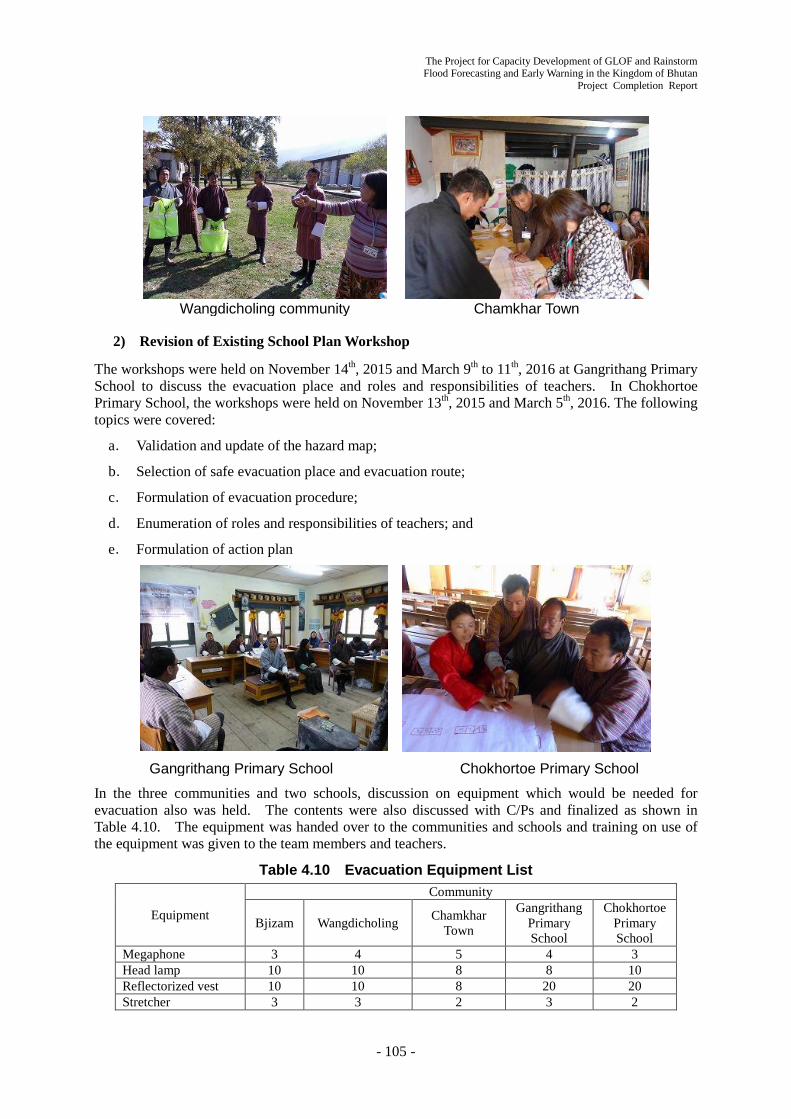
The Project for Capacity Development of GLOF and Rainstorm Flood Forecasting and Early Warning in the Kingdom of Bhutan
Project Completion Report
- 105 -
Wangdicholing community Chamkhar Town
2) Revision of Existing School Plan Workshop
The workshops were held on November 14th, 2015 and March 9th to 11th, 2016 at Gangrithang Primary School to discuss the evacuation place and roles and responsibilities of teachers. In Chokhortoe Primary School, the workshops were held on November 13th, 2015 and March 5th, 2016. The following topics were covered:
a. Validation and update of the hazard map;
b. Selection of safe evacuation place and evacuation route;
c. Formulation of evacuation procedure;
d. Enumeration of roles and responsibilities of teachers; and
e. Formulation of action plan
Gangrithang Primary School Chokhortoe Primary School
In the three communities and two schools, discussion on equipment which would be needed for evacuation also was held. The contents were also discussed with C/Ps and finalized as shown in Table 4.10. The equipment was handed over to the communities and schools and training on use of the equipment was given to the team members and teachers.
Table 4.10 Evacuation Equipment List
Equipment
Community
Bjizam Wangdicholing Chamkhar Town
Gangrithang Primary School
Chokhortoe Primary School
Megaphone 3 4 5 4 3 Head lamp 10 10 8 8 10 Reflectorized vest 10 10 8 20 20 Stretcher 3 3 2 3 2
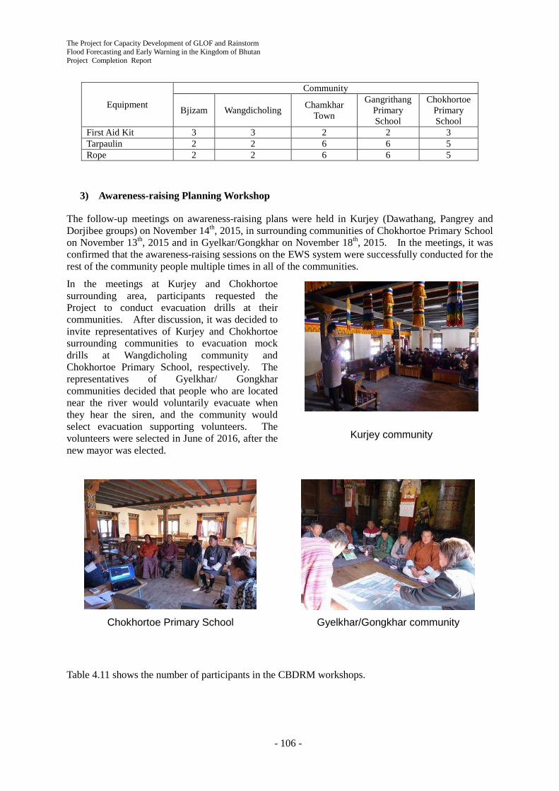
The Project for Capacity Development of GLOF and Rainstorm Flood Forecasting and Early Warning in the Kingdom of Bhutan Project Completion Report
- 106 -
Equipment
Community
Bjizam Wangdicholing Chamkhar Town
Gangrithang Primary School
Chokhortoe Primary School
First Aid Kit 3 3 2 2 3 Tarpaulin 2 2 6 6 5 Rope 2 2 6 6 5
3) Awareness-raising Planning Workshop
The follow-up meetings on awareness-raising plans were held in Kurjey (Dawathang, Pangrey and Dorjibee groups) on November 14th, 2015, in surrounding communities of Chokhortoe Primary School on November 13th, 2015 and in Gyelkar/Gongkhar on November 18th, 2015. In the meetings, it was confirmed that the awareness-raising sessions on the EWS system were successfully conducted for the rest of the community people multiple times in all of the communities.
In the meetings at Kurjey and Chokhortoe surrounding area, participants requested the Project to conduct evacuation drills at their communities. After discussion, it was decided to invite representatives of Kurjey and Chokhortoe surrounding communities to evacuation mock drills at Wangdicholing community and Chokhortoe Primary School, respectively. The representatives of Gyelkhar/ Gongkhar communities decided that people who are located near the river would voluntarily evacuate when they hear the siren, and the community would select evacuation supporting volunteers. The volunteers were selected in June of 2016, after the new mayor was elected.
Chokhortoe Primary School Gyelkhar/Gongkhar community
Table 4.11 shows the number of participants in the CBDRM workshops.
Kurjey community

The Project for Capacity Development of GLOF and Rainstorm Flood Forecasting and Early Warning in the Kingdom of Bhutan
Project Completion Report
- 107 -
Table 4.11 Number of Participants in CBDRM Workshops
Community Date
(YYYY/MM/DD)
Workshop Participants Affected Population
Total Central District
Gewog/ Tromde
Community
Directly Affected
Indirectly Affected DHMS DDM
Flood Warning Evacuation Planning Workshop
Wangdicholing 2015/11/16 12 1 11 74 300 2016/02/29 10 2 1 7
Bjizam 2015/11/19 15 1 14 51 150 2016/02/25 18 2 1 15
Chamkar Town 2015/11/14 14 1 13 580 1,000 2016/03/14 103 1 1 2 99 Integration of Existing Flood Evacuation Planning Workshop
Gangrithang Primary School
2015/11/14 19 1 1 17 300 600 2016/03/9-11 20 2 1 17 Chokhortoe
Primary School 2016/11/13 13 1 1 11 600 200 2016/03/05 11 2 1 1 7
Follow-up Meeting on Awareness-raising Plan
Kurjey 2015/11/14 7 1 1 5 440 500 2016/03/05 34 2 1 1 30 Chockhortoe
(Activity of the surrounding
communities)
2015/11/13 8 1 1 6 Same as Chokhortoe
Primary School 2016/03/07
16 2 1 1 12
Gyelkar/ Gongkar
2015/06/18 14 1 13 100 200 2016/03/08 28 2 1 25 Total 342 19 14 7 302 2,145 2,950
4) Conduct of Evacuation Mock Drill
The evacuation mock drill was conducted on March 1, 2016 at Wangdicholing community where 49 people participated. Six (6) representatives from Kurjey community observed the mock drill. At Kurjey community, a presentation on the mock drill was held for the rest of the community on March 5th, 2016. At Chokhortoe Primary School, the mock drill was conducted on March 7th, 2016; 96 students and 9 teachers participated. Twelve community representatives from the surrounding communities observed the drill. On March 12th, 2016, Gangrithang Primary School conducted the mock drill; 282 students and 19 teachers participated. In the mock drill, the Governor of Bumthang District, Director of DDM, two (2) DDM staff and four (4) DHMS staff participated as observers. On March 15th, evacuation mock drill was conducted in Chamkhar Town where 183 people participated. The Governor of Bumthang District observed the drill. At Bjizam, the drill was conducted on March 16th, 2016; 48 people participated. In all the communities and schools, C/Ps from the central, district and/ or Gewog levels participated. They worked actively with community people from the preparation phase to de-briefing sessions which were conducted after mock drills. Table 4.12 shows the number of participants to the mock drills.
Table 4.12 Number of Participants in Evacuation Mock Drill
Community Date (YYYY/MM/DD) Community DHMS DDM District Gewog/
Tromde Other
Community Wangdicholing 2016/03/01 49 2 1 1 6
Chokhortoe Primary School 2016/03/07 105 2 1 1 12
Gangrithang Primary School 2016/03/12 301 4 3 2
Chamkhar Town 2016/03/15 183 1 1 2 2 Bjizam 2016/0316 48 1 1
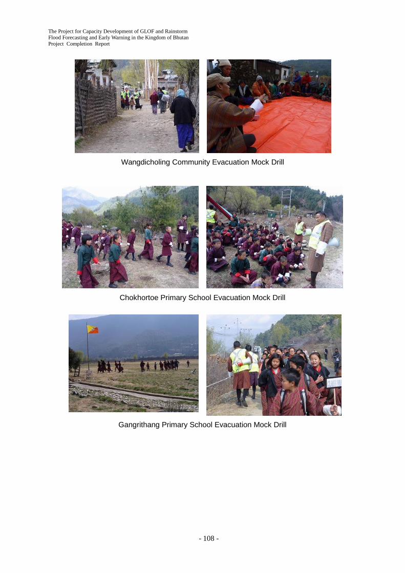
The Project for Capacity Development of GLOF and Rainstorm Flood Forecasting and Early Warning in the Kingdom of Bhutan Project Completion Report
- 108 -
Wangdicholing Community Evacuation Mock Drill
Chokhortoe Primary School Evacuation Mock Drill
Gangrithang Primary School Evacuation Mock Drill

The Project for Capacity Development of GLOF and Rainstorm Flood Forecasting and Early Warning in the Kingdom of Bhutan
Project Completion Report
- 109 -
Chamkhar Town Community Evacuation Mock Drill
Bjizam Community Evacuation Mock Drill
4.4.2 SOP on Emergency Information Sharing in the Basins (Activity 3-4)
1) Basic Concept of SOP in the Basins
Flood early warning as well as emergency response should be completed in the basin under the initiative of Dzongkhag Emergency Operation Center (Dzongkhag EOC) and Dzongkhag Disaster Management Officer (DDMO). The newly established Control Center is the only provider of river related information in the basin. Therefore, strengthening the emergency communication between the Control Center and Dzongkhag is very important.
The SOP was formulated between DHMS and the Expert Team according to the following concepts:
Concept of SOP in the basins
The SOP does not cover entire emergency response in Dzongkhag disaster management, but guides emergency communication on river related information between the information provider and Dzongkhag administrator.
The SOP shall be a reference of Dzongkhag Contingency Plan stipulated in Disaster Management Act in future.
Role of Control Center

The Project for Capacity Development of GLOF and Rainstorm Flood Forecasting and Early Warning in the Kingdom of Bhutan Project Completion Report
- 110 -
The Control Center is just an information provider, not a decision maker.
To avoid confusion in emergency situation, information access to the Control Center from outside (officials and individuals) should be minimized
2) Workshops on SOP in the Basin
Stakeholder meetings in Trongsa and Bumthang were held on February 26 and 29, 2016 to discuss the basic concept of the SOP. Members of Dzongkhag disaster management committee (governor, vice governor, Dzongkhag officers, police, representative of monks), Mangdechhu Hydro Power Authority (MHPA), Bumthang Airport, principals of primary schools, DHMS and DDM staff participated in the meetings. In the meetings, evacuation planning and drills were reviewed and information sharing schemes were actively discussed among the stakeholders.
MHPA is one of the most important stakeholders in the Mangdechhu river basin. In order to introduce the EWS to MHPA administrators and construction workers in the site, a technical workshop was held on June 3, 2016. Since the EWS is valuable for MHPA in view of safety management of dam construction as well as dam operation after the construction, many technical advices and suggestions were raised in the workshop. Practical suggestions such as call-off process of error warning are very important to improve the SOP.
Stakeholder Meeting in Trongsa
Stakeholder Meeting in Bumthang
SOP Workshop in MHPA
3) Formulation of SOP in the Basin
Considering suggestions from stakeholders, the general communication flow in SOP was prepared as shown in Figure 4.5.
Key points of the communication flow are 1) no direct communication between the Control Center and any agencies in the central government other than NWFWC and 2) no direct communication between the Control Center and vulnerable communities in order to minimize the access to the Control Center. By way of exception, however, MHPA in the Mangdechhu river basin and Airport in the Chamkharchhu river basin can communicate with the Control Center because timely information is essential for these stakeholders.
The general communication flow and practical procedure for information sharing were introduced to the relevant agencies in the project final seminar.

The Project for Capacity Development of GLOF and Rainstorm Flood Forecasting and Early Warning in the Kingdom of Bhutan
Project Completion Report
- 111 -
Figure 4.5 Basic Information Flow in the SOP
DHMS and the Expert Team conducted field survey and interview in the Dzongkhags and communities after the serious flood disaster on July 2016 in order to reflect the real experience in the SOP.
In Bumthang, the governor directly instructed information collection and evacuation of local residents during the flood. In the current situation that the Dzongkhag EOC has not been established, such strong initiative of the governor was effective in emergency situation. Further, it was realized that the mobile communication was still effective for evacuation direction in addition to the warning siren unless there is a network shutdown. On the other hand, in Trongsa, MHPA requested DHMS to review the Alert and Alarm levels based on the experience of the flood.
Considering the above lessons learned, the SOP were modified and finalized by DHMS and the Expert Team. The SOP shall be continuously revised by DHMS and DDM adjusting with the Dzongkhag Contingency Plan after the Project.
SOP in the Chamkharchhu Basin
The Project for Capacity Development of GLOF and Rainstorm Flood Forecasting and Early Warning in the Kingdom of Bhutan Project Completion Report
- 112 -
Change in Counterpart State by Technical Transfer Chapter 5
The C/P state such as awareness and capacity by the technical transfer was greatly enhanced through the Project activities for three (3) years from the kick-off in September 2013 to the Project completion in September 2016 as shown in Table 5.1.
Table 5.1 Change in C/P State by Technical Transfer No. Activities Progress
Ratio (%)
Change in C/P (such as awareness and capacity)
Output 1
Capacity of DHMS and relevant stakeholders on emergency response against GLOF/rainstorm flood is enhanced.
1-1 Analysis of present state of NWFWC on existing hydro-met data, monitoring and warning
100 <July 2015> No particular technical transfer is included in this activity, since the main C/P's activities are the collaborative work such as provision of information with the JICA Expert Team who analyzed the present status. As for the GTS installation, the C/P's assisted the coordination with related international agencies.
1-2 Installation of necessary facilities to develop integrated platform and beginning its operation
50 <September 2014> DHMS's proactive and positive participation to the activity has always been very high from the kick-off till present. For the GTS installation, DHMS C/Ps participated actively in the provision of information, discussion, and coordination with related agencies with the JICA Expert Team.
70 <July 2015> With the continuous proactive involvement, the C/P's assisted the JICA Contractor during the GTS installation work. The C/P prepared the GTS O/M manual with the JICA Expert.
100 < March 2016> With the continuous proactive involvement, the C/P assisted in the GTS installation work and participated in the GTS O/M manual preparation and trainings. As a final output, DHMS started 24/7 GTS operation by March 2016.
1-3 Run-off and flood analyses based on potential GLOF and climate change
0 <October 2013> As for flood risk analysis and hazard map preparation, several C/P agencies conducted activity independently without clear demarcation between agencies, information sharing and coordinating mechanism to discuss related issues.
90 <September 2014> Flood Hazard Map working group (FHM W/G) was organized with all the C/P agencies (DHMS, DDM, DGM, DoES, NLCS and DHS) as members to meet and discuss periodically. Daily activities and trainings have been planned and conducted

The Project for Capacity Development of GLOF and Rainstorm Flood Forecasting and Early Warning in the Kingdom of Bhutan
Project Completion Report
- 113 -
No. Activities Progress Ratio (%)
Change in C/P (such as awareness and capacity)
based on the discussion in FHM W/G workshops. As a result, related C/P agencies became capable to promote the activity with clearer demarcation and smooth information sharing that resulted from the interaction in the W/G. The C/Ps now have more incentive to join the activity.
100 <July 2015> All the activities were completed, as scheduled, because of the continuation of the favorable condition described above.
1-4 Discussion to enhance coordination between GLOF/ flood risk assessment sector and development sector
0 <October 2013> No C/P agencies had particular awareness on MDRR excluding DDM in charge of disaster management administration. Even though Disaster Management Act enacted in 2013 clearly declared MDRR in all the sectors and agencies, there was no mechanism and opportunity for the C/P agencies to discuss and coordinate on MDRR.
50 <September 2014> Similar to FHM W/G mentioned above, MDRR W/G was organized for all the six C/P agencies to meet and discuss periodically. Activities have been planned and conducted through the W/G workshops. As a result of free discussion in the series of workshops, all the C/P agencies started to have common understanding of MDRR issues on institution and related disaster management subjects and their future conceivable solutions. The motivation of each C/P agency on the promotion of MDRR has been strengthened greatly.
80 <July 2015> The good coordination through the W/G will be developed into the Inter-Ministerial Task Force stipulated in Disaster Management Act 2013 even after the completion of the Project
100 <July 2016> All the activities were completed, as scheduled, because of the continuation of the favorable condition described above.
1-5 Preparation and improvement of hazard map through training for relevant agencies
0 <September 2014> No activity
50 < July 2015> The activity has started based on the favorable coordination through the W/G formulated in Activity 1-3. The W/G will be developed into the Inter-Ministerial Task Force stipulated in Disaster Management Act 2013 even after the completion of the Project

The Project for Capacity Development of GLOF and Rainstorm Flood Forecasting and Early Warning in the Kingdom of Bhutan Project Completion Report
- 114 -
No. Activities Progress Ratio (%)
Change in C/P (such as awareness and capacity)
100 <August 2016> All the activities completed, as scheduled, because of the continuation of the favorable condition described above.
1-6 Awareness raising in relating agencies on land use management against disaster
0 <October 2013> Some C/P agencies had the awareness on land use management for disaster separately. For example, the DHS formulated the Bumthang master plan while the NLCS was in charge of land use regulation. The awareness of the C/P agencies was not so high, since there was no mechanism for the C/P agencies to exchange information, discuss and coordinate on this issue.
30 <September 2014> The W/G formulated in Activity 1-4 has also conducted these activities with the regular W/G members, since the land use issue is very much related to MDRR. As a result of the discussion and information sharing based on the presentation of particular examples by each participant in the workshop, all the C/P agencies started to have common understanding of land use issues to promote future action planning activities.
100 <July 2015> The good coordination through the W/G will be developed into Inter-Ministerial Task Force stipulated in Disaster Management Act 2013 even after the completion of the Project.
1-7 Proposal of institution and legal system necessary for mainstreaming disaster risk assessment into development plan
0 <September 2014> No activity
30 <July 2015> With the high awareness of DDM after the big earthquake in Nepal on April 25, 2015, the joint analysis of present status and issues on the disaster management system in Bhutan was smoothly implemented.
100 <June 2016> The W/G formulated in Activity 1-4 has also conducted this activity with the regular W/G members, since the institutional issue is very much related to MDRR. As a result of the discussion and information sharing based on the presentation by each participant in workshop, all the W/G members now share a common understanding that Inter Ministerial Task Force stipulated in DM Act 2013 will be the appropriate institution for the purpose.

The Project for Capacity Development of GLOF and Rainstorm Flood Forecasting and Early Warning in the Kingdom of Bhutan
Project Completion Report
- 115 -
No. Activities Progress Ratio (%)
Change in C/P (such as awareness and capacity)
1-8 Improvement of flood and weather forecasting system utilizing numerical weather prediction data (GPV) by use of accumulated hydro-meteorological data
0 <September 2014> No activity
25 <July 2015> The awareness of the C/P was increased after participating at the C/P training on SATAID in Japan in November 2014. The activities on the preparation of manuals and training have been implemented smoothly after May 2015 with active involvement of the C/P.
100 <June 2016> As the awareness of the C/P increased after the commencement of the GTS and HimawariCast operation in March 2016, all the training activities using the equipment were completed as planned.
1-9 Development of SOP on emergency information sharing through discussion and workshop with relevant agencies
0 <July 2015> No activity
100 <August 2016> The W/G formulated in Activity 1-4 has also conducted this activity with the regular W/G members, since the institutional issue is very much related to MDRR. As a result of the discussion and information sharing based on the presentation by each participant in workshop, the SOP was smoothly developed.
Output 2
Early Warning System (EWS) for GLOF/rainstorm is developed and maintained in the pilot basins of Mangdechhu and the Chamkharchhu.
2-1 Analysis of current condition and extraction of issue on existing meteorological and hydrological observation network and proposed water power plant
100 <September 2014> No particular technical transfer is included in this activity, since the main C/P's activities were the collaborative work such as provision of information and joint field reconnaissance with the JICA Expert Team who analyzed the present status.
2-2 Collecting and analyzing fundamental information for design of early warning system in basins
100 <September 2014> DHMS showed high initiative for the activity from the beginning in October 2013, since they already have the experiences in EWS installation, operation and maintenance, and SOP preparation in adjacent river basins supported by UNDP. The main C/P's activities were the provision of information, discussion, joint field reconnaissance, coordination with related agencies including land allocation and preparation of EWS technical specification by JICA Expert Team.
2-3 Distribution plan and specification of EWS in pilot basins
100
2-4 Installation of equipment and facilities in pilot basins and NWFWC
20 <September 2014> As described above, DHMS showed high initiative for the activity. The main C/P's activity was the active support for the preparatory civil works conducted by the JICA Expert Team

The Project for Capacity Development of GLOF and Rainstorm Flood Forecasting and Early Warning in the Kingdom of Bhutan Project Completion Report
- 116 -
No. Activities Progress Ratio (%)
Change in C/P (such as awareness and capacity)
80 <July 2015> DHMS's proactive and positive participation on the activities were always very high. They dispatched many staff, at its own expense, to assist the field EWS installation work such as the preliminary field survey in October 2014 and the EWS installation work in May – June 2015 by JICA Contractor with JICA Expert Team.
100 <March 2016> With the continuous proactive involvement, DHMS dispatched many staff, at its own expense, to assist the field EWS installation work for several months in September - October 2015 and February - March 2016. As a final output, DHMS started 24/7 EWS operation in May 2016.
2-5 Preparation of Manual for EWS operation and maintenance and training for central and local DHMS staff
0 <September 2014> No activity
40 <July 2015> As described in Activity 2-3, DHMS showed high initiative for the activity. Therefore, the C/P actively participated in the O/M manual preparation and the training with the JICA Expert.
100 <June 2016> All the activities were completed as scheduled because of the continuation of the favorable condition described above. <July 2016> Because of the extra ordinary continuous monsoon rain, all the EWS warning sirens along the Chamkharchhu were activated upon the water level reaching the Alarm Level at 1:30 AM on July 26. After that, NWFWC and EWS control room staff operated the EWS appropriately during flood using the O/M manual.
Output 3
Emergency response capacity against GLOF/rainstorm flood at central and local level is enhanced in the pilot basins.
3-1 Holding workshops to review flood emergency response on warning and evacuation in the pilot basins
100 <September 2014> DHMS and DDM proactively participated in the kick-off workshops held in the pilot project area. <March 2015> A series of workshops were successfully completed with the better-than-expected proactive participation from district focal person, target communities and schools. DHMS C/P joined the field workshops with JICA Experts for a significant period of time, however, the involvement of DDM C/P was not so high.
3-2 List target communities and examine flood warning criteria in pilot basins
100
3-3 Plan and conduct warning and evacuation drills as
0 <September 2014> No activity

The Project for Capacity Development of GLOF and Rainstorm Flood Forecasting and Early Warning in the Kingdom of Bhutan
Project Completion Report
- 117 -
No. Activities Progress Ratio (%)
Change in C/P (such as awareness and capacity)
well as EWS operation drill in the pilot basins
60 <July 2015> With the continuation of favorable condition described in activity 3-2, evacuation planning for target communities and schools was almost completed. DHMS C/P joined the field workshops. However, no participation from DDM.
100 <March 2016> With the continuation of favorable condition described above, evacuation drills for target communities and schools were successfully implemented with the cooperation of DDMO. DHMS and DDM C/P joined the drills. The footage of the drill was repeatedly broadcasted by BBS. <July 2016> Because of the extra ordinary continuous monsoon rain, all the EWS warning sirens along the Chamkharchhu were activated upon the water level reaching the Alarm Level at 1:30 AM on July 26. Upon hearing the siren, all the vulnerable community people evacuated to the safe evacuation place as planned and trained.
3-4 Develop SOP for GLOF/rainstorm flood in pilot basins
0 <July 2015> No activity
80 <June 2016> DHMS C/P and various stakeholders including District Governors in the pilot basins were actively involved in the preparation of draft SOP through discussion and workshops.
100 <August 2016> In the evacuation directive in July 2016 monsoon flood, Bumthang District Governor took an important part by communicating relevant agencies. The Governor presented important recommendation in finalizing the SOP based on his experience during the flood.

The Project for Capacity Development of GLOF and Rainstorm Flood Forecasting and Early Warning in the Kingdom of Bhutan Project Completion Report
- 118 -
Achievement of the Project Purpose Chapter 6
Through the activities of the three Outputs, the capacity of the DHMS and relevant stakeholders on emergency response against GLOF/rainstorm flood has been surely enhanced. The Project outputs and purpose described in the PDM (refer to Appendix 2) were completely achieved at the Project completion in August 2016, three years after the commencement of the Project in September 2013.
In the extra ordinary continuous monsoon rain in late July 2016,all the EWS warning sirens installed along the Chamkharchhu basin were activated when the water level reached the Alarm Level at 1:30 AM on July 26. Immediately after, all the vulnerable community people evacuated to the safe evacuation place as planned and trained by the Project. This perfect functioning of the Outputs of the Project activities from the hardware (the operation of the flood EWS) to the software (the evacuation of the target community people) during real flooding verified the high achievement of the Project output and purpose.
6.1 Achievements of Outputs
As shown in Table 6.1, the three Outputs described in the PDM (refer to Appendix 2) were totally achieved at the Project completion in September 2016, since DHMS's proactive and positive participation in the activities have been always very high.
Table 6.1 Achievement of the Project Outputs Outputs in PDM
Objectively Verification Indicators
in PDM
Achievement as of August
2016
Notes
1: Capacity of related agencies on GLOF/rainstorm flood risk assessment, development planning, disaster prevention, flood forecasting and warning as well as emergency information sharing among relevant agencies is enhanced.
a. Plan of institutional strengthening for mainstreaming disaster risk assessment information into development plans is formulated.
100% The baseline survey on related agencies was completed in December 2013. Related issues such as the establishment of the Inter Ministerial Task Force in the Disaster Management Act 2013 were discussed in the Mainstreaming Disaster Risk Reduction Working Group from February 2014 to August 2016.
b. Equipment and facilities for NWFWC are installed as scheduled and utilized as planned.
100% The specification document on the equipment (GTS/MSS) was completed in Jul 2014. A JICA contractor was officially selected in August 2014. The installation work started in May 2015 and completed in March 2016. DHMS started 24/7 operation since March 2016. GTS O/M manual was prepared and the trainings were conducted from April 2015 to April 2016.
The Project for Capacity Development of GLOF and Rainstorm Flood Forecasting and Early Warning in the Kingdom of Bhutan
Project Completion Report
- 119 -
Outputs in PDM
Objectively Verification Indicators
in PDM
Achievement as of August
2016
Notes
c. GLOF/rainstorm flood risk zonation maps are developed.
100% The zonation map was finalized in November 2015 through Flood Hazard Map Working Group. The trainings using the map preparation manual were conducted in November 2015. The map preparation in other river basin (Thimphuchhu) and the trainings were conducted in March - July 2016.
d. Flood and weather forecasting is delivered daily by utilizing improved forecasting system.
100% The C/P training in Japan on SATAID was conducted in November 2014. The installation of GTS/MSS and HimawariCast receiver was completed in March 2016. DHMS started 24/7 weather forecasting and its delivery in March 2016. The weather forecasting manual was prepared and the trainings were conducted from May 2015 to June 2016.
e. SOP on emergency information sharing is developed
100% The SOP was discussed and developed in the Mainstreaming Disaster Risk Reduction Working Group in June and August 2016.
2: Early Warning System (EWS) for GLOF/rainstorm is developed and maintained in the pilot basins of Mangdechhu and Chamkharchhu.
a. Equipment and facilities for EWS are installed as scheduled and utilized as planned.
100% The specification document on the equipment was completed in July 2014. A JICA contractor was officially selected in Aug 2014. The installation work started in May 2015 and completed in March 2016. DHMS started 24/7 operation in May 2016. At 1:30 AM on July 26, 2016, because of the extra ordinary continuous monsoon rain, all the EWS warning sirens along the Chamkharchhu were activated automatically as planned and designed upon the water level reaching the Alarm Level.
b. EWS operation and maintenance manual is developed.
100% The manual was developed from April 2015 to June 2016.
c. Trainings for the operation and maintenance of EWS are conducted by use of the manual. (All DHMS staff in charge will join the trainings).
100% The trainings were conducted from June 2015 to June 2016 based on the manual mentioned above. At 1:30 AM on July 26, 2016, because of the extra ordinary continuous monsoon rain, all the EWS warning sirens along the Chamkharchhu were activated upon the water level reaching the Alarm Level. After that, NWFWC and EWS control room staff
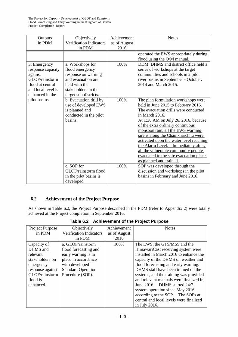
The Project for Capacity Development of GLOF and Rainstorm Flood Forecasting and Early Warning in the Kingdom of Bhutan Project Completion Report
- 120 -
Outputs in PDM
Objectively Verification Indicators
in PDM
Achievement as of August
2016
Notes
operated the EWS appropriately during flood using the O/M manual.
3: Emergency response capacity against GLOF/rainstorm flood at central and local level is enhanced in the pilot basins.
a. Workshops for flood emergency response on warning and evacuation are held with the stakeholders in the target sub-districts.
100% DDM, DHMS and district office held a series of workshops at the target communities and schools in 2 pilot river basins in September - October. 2014 and March 2015.
b. Evacuation drill by use of developed EWS is planned and conducted in the pilot basins.
100% The plan formulation workshops were held in June 2015 to February 2016. The evacuation drills were conducted in March 2016. At 1:30 AM on July 26, 2016, because of the extra ordinary continuous monsoon rain, all the EWS warning sirens along the Chamkharchhu were activated upon the water level reaching the Alarm Level. Immediately after, all the vulnerable community people evacuated to the safe evacuation place as planned and trained.
c. SOP for GLOF/rainstorm flood in the pilot basins is developed.
100% SOP was developed through the discussion and workshops in the pilot basins in February and June 2016.
6.2 Achievement of the Project Purpose
As shown in Table 6.2, the Project Purpose described in the PDM (refer to Appendix 2) were totally achieved at the Project completion in September 2016.
Table 6.2 Achievement of the Project Purpose Project Purpose
in PDM Objectively
Verification Indicators in PDM
Achievement as of August
2016
Notes
Capacity of DHMS and relevant stakeholders on emergency response against GLOF/rainstorm flood is enhanced.
a. GLOF/rainstorm flood forecasting and early warning is in place in accordance with developed Standard Operation Procedure (SOP).
100% The EWS, the GTS/MSS and the HimawariCast receiving system were installed in March 2016 to enhance the capacity of the DHMS on weather and flood forecasting and early warning. DHMS staff have been trained on the systems, and the training was provided and relevant manuals were finalized in June 2016. DHMS started 24/7 system operation since May 2016 according to the SOP. The SOPs at central and local levels were finalized in July 2016.

The Project for Capacity Development of GLOF and Rainstorm Flood Forecasting and Early Warning in the Kingdom of Bhutan
Project Completion Report
- 121 -
Project Purpose in PDM
Objectively Verification Indicators
in PDM
Achievement as of August
2016
Notes
After that, at 1:30 AM on July 26, 2016, because of the extra ordinary continuous monsoon rain, all the EWS warning sirens along the Chamkharchhu were activated upon the water level reaching the Alarm Level. After that, NWFWC and EWS control room staff operated the EWS appropriately during flood using the O/M manual and communicate with Bumthang District Office and DDM according to the SOP. That appropriate procedure resulted in the safety evacuation of the target community people.
b. Early warning and evacuation drills in the pilot basins are regularly conducted by use of developed EWS (at least once in a year).
100% Since the EWS operation and evacuation drills were conducted for the first time at the time of the terminal evaluation as originally planned, it is difficult to verify the regular implementation of the drills. The target communities, however, were committed to the CBDRM activities including the preparation for the drills. Additionally, the DDM plans to incorporate the evacuation plans including a regular drill into the DDMP for Bumthang. Hence these achievements suggest that the drills in the pilot river basins will be conducted regularly. At 1:30 AM on July 26, 2016, because of the extra ordinary continuous monsoon rain, all the EWS warning sirens along the Chamkharchhu were activated upon the water level reaching the Alarm Level. Immediately after, all the vulnerable community people evacuated to the safe evacuation place as planned and trained. As a result of conducting the real evacuation action, the awareness of the relevant agencies and the target community people has highly increased. Their motivation to conduct periodical evacuation drill and the revision of evacuation plan in future is judged high enough.
The Project for Capacity Development of GLOF and Rainstorm Flood Forecasting and Early Warning in the Kingdom of Bhutan Project Completion Report
- 122 -
Issues and Lessons Learned Chapter 7
7.1 GTS/MSS and EWS Installation
The installation of the equipment for the GTS/MSS in NWFWC and the EWS for two pilot river basins were initially planned to be completed in May 2015. However, the installation work was delayed and completed in March 2016. Accordingly, the Project objective achievement on this output has fallen short of expectations. The initial installation schedule should have been examined more carefully, since the installation is the critical area of the overall Project progress.
The related Project activity schedule such as the GTS/MSS and EWS manual preparation and training was reviewed and postponed reflecting this delay. As a result, it was confirmed that the influence of the delay to the related activities was limited and the activities were successfully conducted in the 2nd Phase (October 2015 – August 2016) without significant schedule change.
7.2 Overall Activities
Overall Project activities other than 1) mentioned-above implemented smoothly almost as planned with the positive and independent participation of all the counterpart agencies. Accordingly, it is judged that the Project Purpose was satisfactorily achieved as described in the previous chapter. The achievement of the Project Purpose was also verified visually through the implementation of the flood EWS operation, the activation of all the warning sirens and the evacuation from all the target vulnerable communities in Chamkharchhu basin during July 2016 monsoon flooding.
Communication between the JICA Expert Team and their counterparts has been very good. The DHMS made sure that most JICA experts occupied the same office space with his/her DHMS counterparts. This office arrangement worked well to ensure communication between them.
The capacity development of DHMS has been achieved effectively because of their high motivation and initiative in not only daily Project activities in Thimphu but also field activities in the two pilot river basins. What is effective for the remarkable technical transfer and capacity development of the counterpart is that DHMS dispatched a total of 16 staff to the Pilot Project Areas for several months, at its own expense, to assist the EWS installation work by JICA Contractor with the cooperation of the JICA Expert Team.
The participation of five sub-counterpart agencies, DDM, DGM, DoES, NLCS and DHS to the Project activity is also very positive and active. The coordination between the counterpart agencies has been strengthened through periodical Working Group Workshops especially the flood hazard mapping and mainstreaming disaster risk reduction working groups. These effective working group activities will strongly be promoted sustainably. With the introduction of the Working Group mechanism, it is decided that the Working Groups will be elevated into Inter-Ministerial Task Force stipulated in Disaster Management Act 2013 after the completion of the Project. The Task Forces for other disasters such as earthquake, landslide and fire will be organized by reference to the Working Group of the Project.
7.3 DDM/ DHMS Support for District Government on EWS Sensitization
At 1:30 AM on July 26, 2016, because of the extra ordinary continuous monsoon rain, all the EWS warning sirens along the Chamkharchhu were activated upon the water level reaching the Alarm Level. Immediately after, all the vulnerable community people evacuated to the safe evacuation place as planned and trained. However, the people who inhabited the safe area outside the flood risk area got panics and evacuated after listening the siren sound, since the siren sound reached very far than expected and they were not informed about the EWS at all.

The Project for Capacity Development of GLOF and Rainstorm Flood Forecasting and Early Warning in the Kingdom of Bhutan
Project Completion Report
- 123 -
The important lessons learned from the series of events happened in the July 26, 2016 flood is the importance and necessity of further and continuous sensitization by Bumthang District Office on the EWS installed by the Project, which will not only be the periodical evacuation mock drill at vulnerable communities but also the general awareness raising for other general public inhabited in entire Bumthang valley.
In this context, it was agreed by DDM and DHMS to support Bumthang District Office financially and technically for their future sensitization activities.
- 124 -
Recommendations to Achieve Overall Goal Chapter 8
The Overall Goal of the Project (to be achieved 3 to 5 years after this Project completion) and the Objectively Verifiable Indicators are described in the Project Design Matrix (PDM) (refer to Appendix 2) as follows:
Overall Goal: Nationwide disaster resilient society against natural disasters such as GLOF and rainstorm flood for Climate Change Adaptation is realized in Bhutan.
Objectively Verifiable Indicator a:GLOF/rainstorm flood forecasting and early warning is properly disseminated based on accumulation of hydro-met data to relevant agencies at central and local level as well as outside of pilot river basin.
Objectively Verifiable Indicator b:Evacuation drills are conducted at least one community outside of pilot river basin with EWS.
The recommendations to achieve the Overall Goal are as follows:
Recommendation on the Objectively Verifiable Indicator a:
1. The accumulation of the observation data by using the flood EWS, GTS/MSS and HimawariCast receiving System is an issue in the future, since the operation of those equipment just started in March 2016. It is recommended that NWFWC to raise the accuracy of the flood forecasting and early warning information gradually by reflecting the result of the analysis using the observed long term hydro-met data accumulated in a step-by-step fashion.
2. Raising the accuracy of the weather forecast using the GTS/MSS and HimawariCast receiving system will not be realized soon. Five to 10 years of experience using the equipment will be required. Steady and gradual efforts to raise the accuracy will be essential by continuing the daily weather forecasting using the equipment.
3. As for the other river systems without flood EWS, it is recommended to set tentative alert and alarm water levels based on available information such as flood mark or interview of community people as the basis for the judgement of forecasting and early warning,
Recommendation on the Objectively Verifiable Indicator b:
1. Other than the Pilot river basins, i.e. Mangdechhu and Chamkharchhu basins, it is recommended to install the next Flood Early Warning System (EWS) along the Parochhu and Thimphuchhu river basins that flow through the metropolitan area. It is further recommended to consider this high priority because of the dense population and dense property accumulation on the Paro and Thimphu flood plains.
2. However, as understood through this Project, it is not so easy to install such a full scale flood EWS with flood detecting devices, control room and warning sirens similar to the system installed in the Pilot river basins spending significant budget and time. Even in Japan, it is also noted that not all the major river basins are equipped with such a full scale flood EWS. Therefore, in case of no sufficient DHMS budget, as the first step in the Parochhu and Thimphuchhu river basins, it is recommended to implement the comprehensive measures combining the following structure measures (Simple and practical EWS) and non-structural measures:
i. Structural measures: Installation of simple and practical flood EWS by combining

The Project for Capacity Development of GLOF and Rainstorm Flood Forecasting and Early Warning in the Kingdom of Bhutan
Project Completion Report
- 125 -
a. Issuing flood alert and alarm utilizing the existing automatic weather station (AWS) and automatic water level stations (AWLS) including those to be installed by UNDP NAPA 2 in near future and,
b. Dissemination of the flood alert and alarm to NWFWC of DHMS and target vulnerable communities through the existing communication method such as SMS and SNS.
ii. Non-structural measures: the preparation of flood hazard maps, the promotion of Community Based Disaster Risk Management (CBDRM) at vulnerable communities and schools on the flood plain, formulation of the evacuation plan and the implementation of periodic evacuation drills at the communities and schools
Overall recommendation:
1. July 2016 monsoon big flood is the biggest since Cyclone Aila in 2009 and the worst in terms of the damage to infrastructure. Therefore, it is strongly recommended that the relevant agencies such as DDM, DHMS and DoES to jointly review the response of related agencies and community to the flood and the situation of damage and rehabilitation and then to reflect the review result to future strategy, planning and project through the Working Group of the Inter Ministerial Task Force, since July 2016 flood situation includes so many lessons learned.
2. It is rather difficult to realize nationwide disaster resilient society against natural disasters only by the effort of DHMS. As a core of the disaster management administration in Bhutan, it is essential for DDM to establish and start the operation of National Emergency Operation Centre (NEOC) and Dzongkhag Emergency Operation Centre (DEOC) as soon as possible. The disaster resilient society against natural disasters will finally be realized through the coordination and cooperation of NWFWC (DHMS) and NEOC (DDM) like the two wheels of a cart.

Appendix 1
Record of Discussions


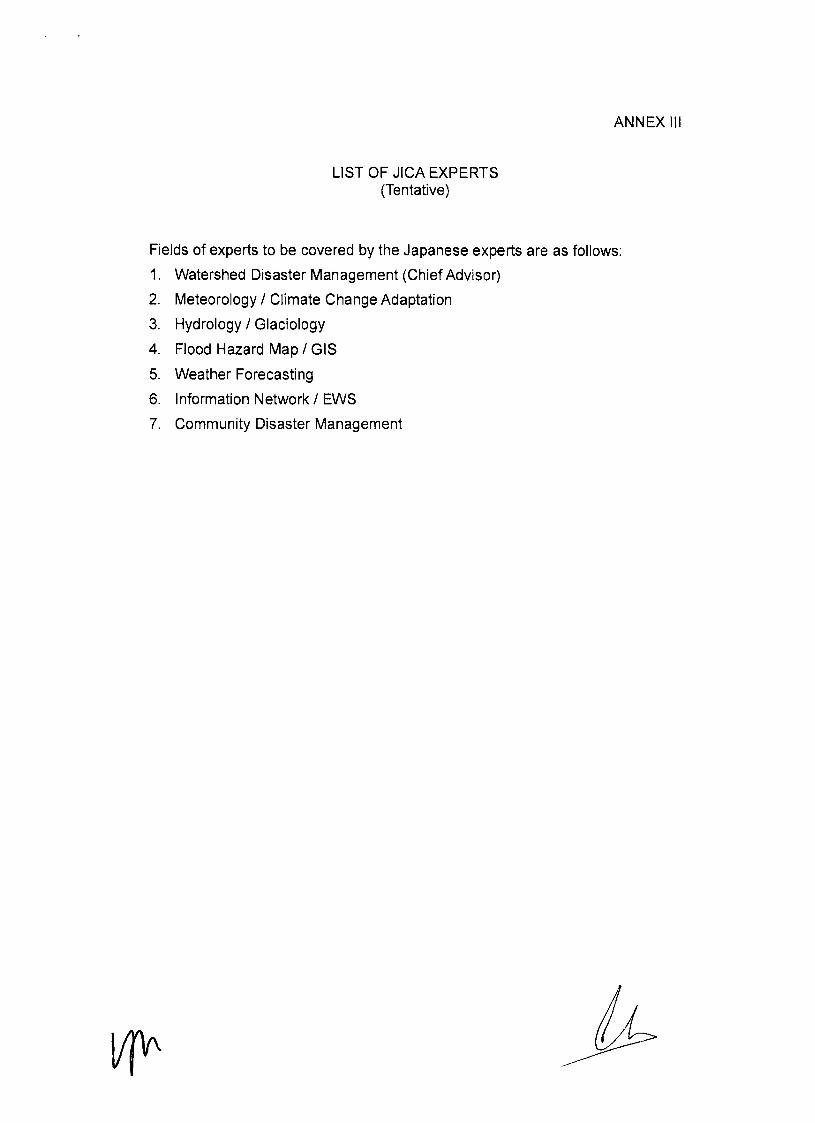

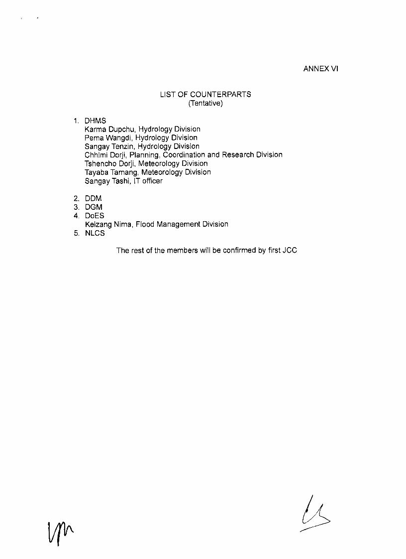


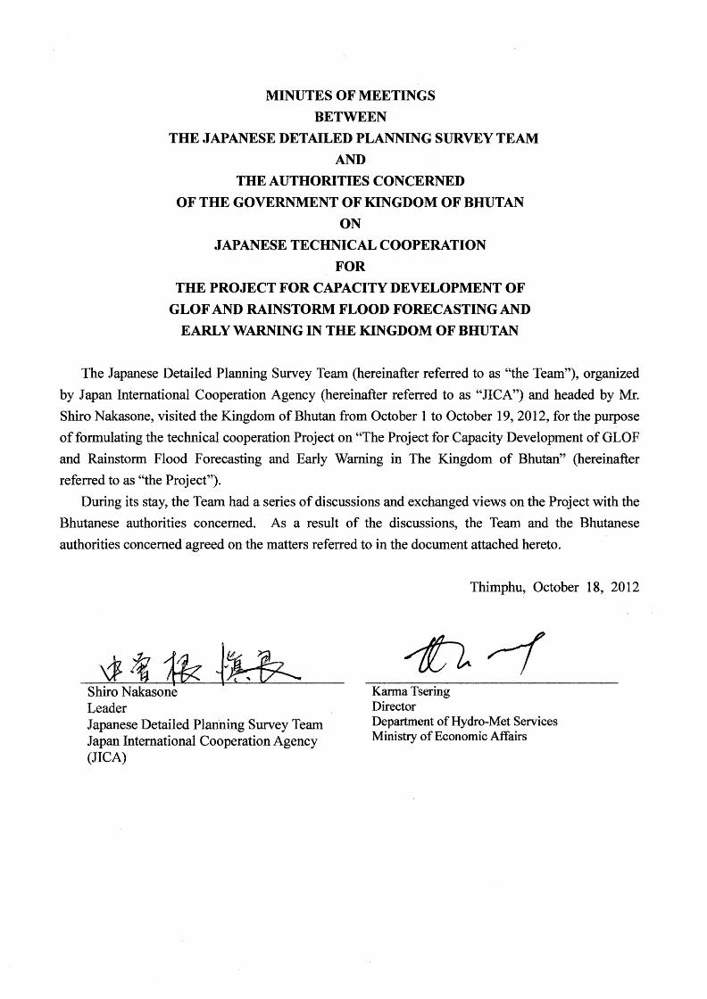
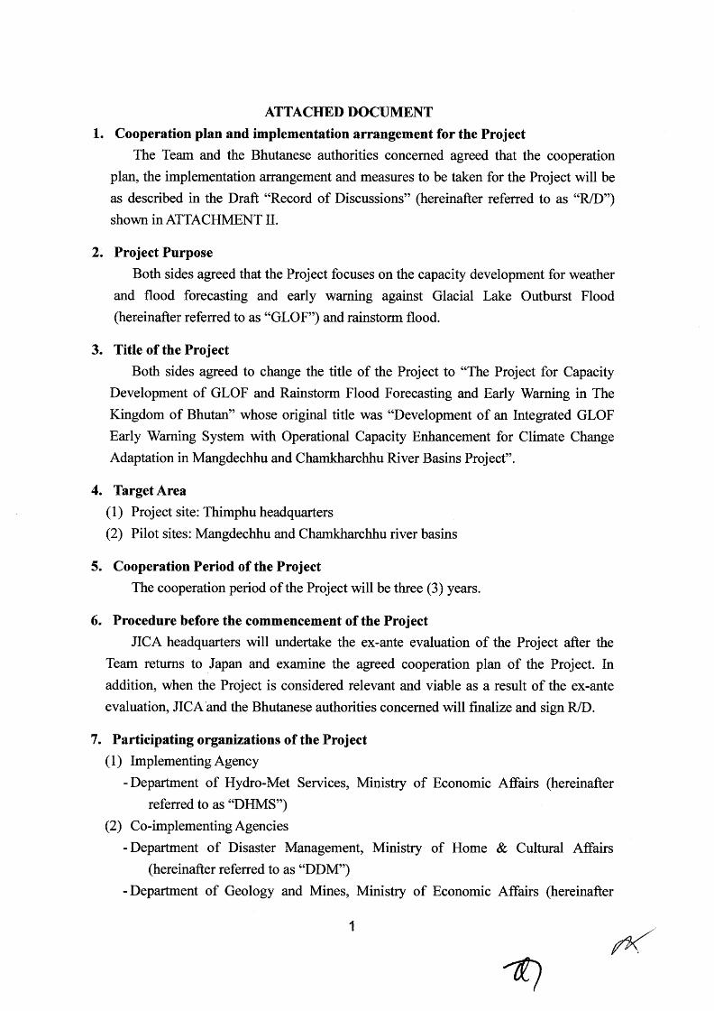


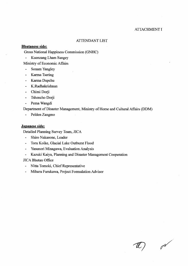


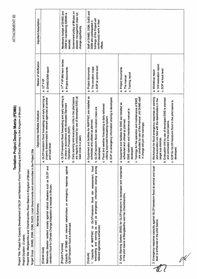
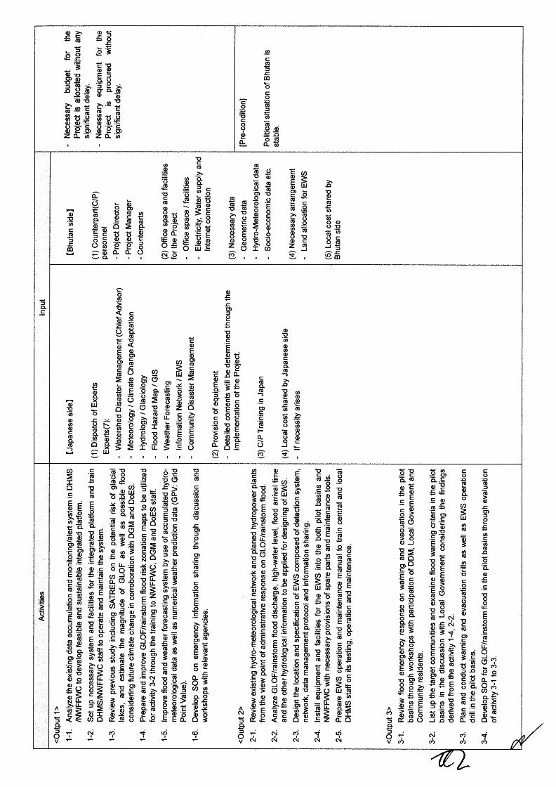

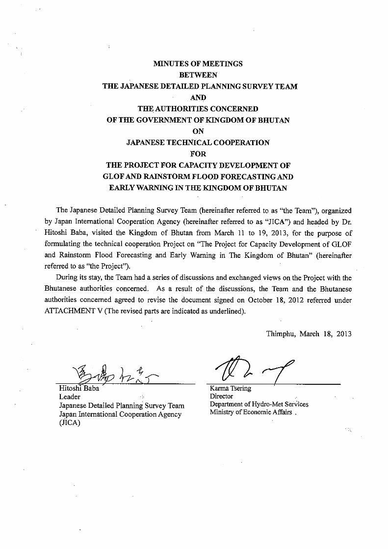


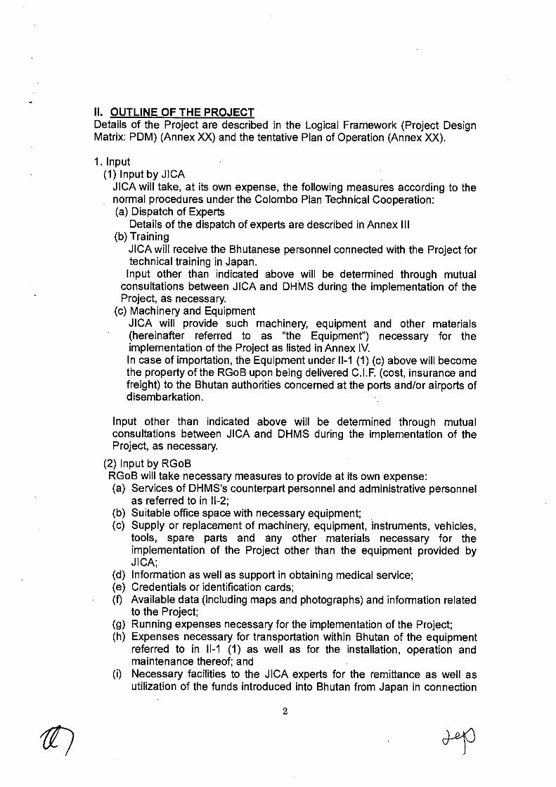


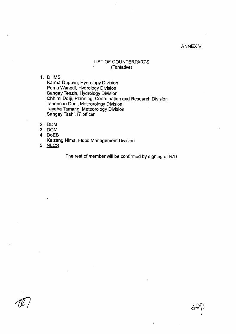
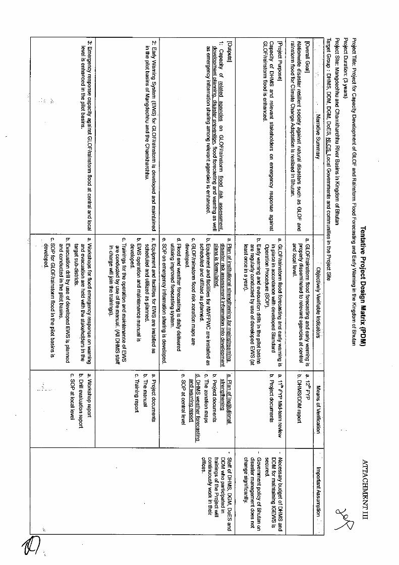


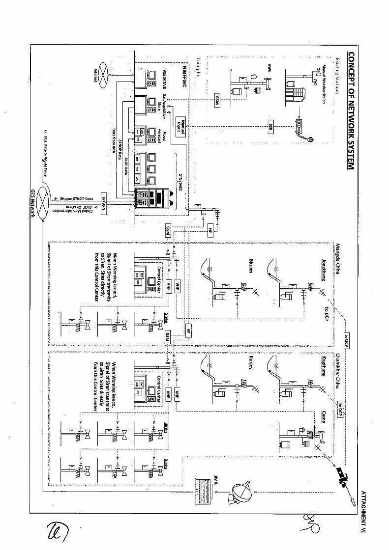


Appendix 2
Project PDM and PO


Proj
ect D
esig
n M
atrix
(PDM
)
Proj
ect T
itle:
Pro
ject
for C
apac
ity D
evel
opm
ent o
f GLO
F an
d R
ains
torm
Flo
od F
orec
astin
g an
d Ea
rly W
arni
ng in
the
King
dom
of B
huta
n Pr
ojec
t Dur
atio
n: (3
yea
rs)
Proj
ect S
ite: M
angd
echh
u an
d C
ham
khar
chhu
Riv
er B
asin
s in
Kin
gdom
of B
huta
n Ta
rget
Gro
up: D
HM
S, D
DM
, DG
M, D
oES,
NLC
S, L
ocal
Gov
ernm
ents
and
com
mun
ities
in th
e Pr
ojec
t Site
Nar
rativ
e Su
mm
ary
Obj
ectiv
ely
Verif
iabl
e In
dica
tors
M
eans
of V
erifi
catio
n Im
porta
nt A
ssum
ptio
n
[Ove
rall
Goa
l]
Nat
ionw
ide
disa
ster
res
ilient
soc
iety
aga
inst
nat
ural
dis
aste
rs s
uch
as G
LOF
and
rain
stor
m fl
ood
for C
limat
e C
hang
e Ad
apta
tion
is re
aliz
ed in
Bhu
tan.
a. G
LOF/
rain
stor
m fl
ood
fore
cast
ing
and
early
war
ning
is
prop
erly
dis
sem
inat
ed b
ased
on
accu
mul
atio
n of
hy
dro-
met
dat
a to
rele
vant
age
ncie
s at
cen
tral a
nd
loca
l lev
el a
s w
ell a
s ou
tsid
e of
pilo
t riv
er b
asin
. b.
Eva
cuat
ion
drills
are
con
duct
ed a
t lea
st o
ne
com
mun
ity o
utsi
de o
f pilo
t riv
er b
asin
with
EW
S.
a. 1
2th F
YP
b. D
HM
S/D
DM
repo
rt
[Pro
ject
Pur
pose
] C
apac
ity o
f D
HM
S an
d re
leva
nt s
take
hold
ers
on e
mer
genc
y re
spon
se a
gain
st
GLO
F/ra
inst
orm
floo
d is
enh
ance
d.
a. G
LOF/
rain
stor
m fl
ood
fore
cast
ing
and
early
war
ning
is
in p
lace
in a
ccor
danc
e w
ith d
evel
oped
Sta
ndar
d O
pera
tion
Proc
edur
e (S
OP)
. b.
Ear
ly w
arni
ng a
nd e
vacu
atio
n dr
ills in
the
pilo
t bas
ins
are
regu
larly
con
duct
ed b
y us
e of
dev
elop
ed E
WS
(at
leas
t onc
e in
a y
ear).
a. 1
1th F
YP M
id-te
rm re
view
b.
Pro
ject
doc
umen
ts
- N
eces
sary
bud
get o
f DH
MS
and
DD
M fo
r mai
ntai
ning
IGEW
S is
se
cure
d.
- G
over
nmen
t pol
icy
of B
huta
n on
di
sast
er m
anag
emen
t doe
s no
t ch
ange
sig
nific
antly
.
[Out
puts
] 1:
C
apac
ity
of
rela
ted
agen
cies
on
G
LOF/
rain
stor
m
flood
ris
k as
sess
men
t, de
velo
pmen
t pla
nnin
g, d
isas
ter p
reve
ntio
n, fl
ood
fore
cast
ing
and
war
ning
as
wel
l as
em
erge
ncy
info
rmat
ion
shar
ing
amon
g re
leva
nt a
genc
ies
is e
nhan
ced.
a. P
lan
of in
stitu
tiona
l stre
ngth
enin
g fo
r mai
nstre
amin
g di
sast
er ri
sk a
sses
smen
t inf
orm
atio
n in
to d
evel
opm
ent
plan
s is
form
ulat
ed.
b. E
quip
men
t and
faci
litie
s fo
r NW
FFW
C a
re in
stal
led
as
sche
dule
d an
d ut
ilized
as
plan
ned.
c.
GLO
F/ra
inst
orm
floo
d ris
k zo
natio
n m
aps
are
deve
lope
d.
d. F
lood
and
wea
ther
fore
cast
ing
is d
eliv
ered
dai
ly b
y ut
ilizin
g im
prov
ed fo
reca
stin
g sy
stem
. e.
SO
P on
em
erge
ncy
info
rmat
ion
shar
ing
is d
evel
oped
.
a. P
lan
of In
stitu
tiona
l st
reng
then
ing
b. P
roje
ct d
ocum
ents
c.
The
zon
atio
n m
aps
d. D
HM
S w
eath
er fo
reca
stin
g an
d w
arni
ng re
port
e. S
OP
at c
entra
l lev
el
- St
aff o
f DH
MS,
DG
M, D
oES
, N
LCS
and
DD
M w
ho
parti
cipa
ted
in tr
aini
ngs
of th
e Pr
ojec
t will
cont
inuo
usly
wor
k in
th
eir o
ffice
s.
2: E
arly
War
ning
Sys
tem
(EW
S) fo
r GLO
F/ra
inst
orm
is d
evel
oped
and
mai
ntai
ned
in th
e pi
lot b
asin
s of
Man
gdec
hhu
and
the
Cha
mkh
arch
hu.
a. E
quip
men
t and
faci
litie
s fo
r EW
S ar
e in
stal
led
as
sche
dule
d an
d ut
ilized
as
plan
ned.
b.
EW
S op
erat
ion
and
mai
nten
ance
man
ual i
s de
velo
ped.
c.
Tra
inin
gs fo
r the
ope
ratio
n an
d m
aint
enan
ce o
f EW
S ar
e co
nduc
ted
by u
se o
f the
man
ual.
(All
DH
MS
staf
f in
cha
rge
will
join
the
train
ings
).
a. P
roje
ct d
ocum
ents
b.
The
man
ual
c. T
rain
ing
repo
rt
3: E
mer
genc
y re
spon
se c
apac
ity a
gain
st G
LOF/
rain
stor
m fl
ood
at c
entra
l and
loca
l le
vel i
s en
hanc
ed in
the
pilo
t bas
ins.
a.
Wor
ksho
ps fo
r flo
od e
mer
genc
y re
spon
se o
n w
arni
ng
and
evac
uatio
n ar
e he
ld w
ith th
e st
akeh
olde
rs in
the
targ
et s
ub-d
istri
cts.
b.
Eva
cuat
ion
drill
by u
se o
f dev
elop
ed E
WS
is p
lann
ed
and
cond
ucte
d in
the
pilo
t bas
ins.
c.
SO
P fo
r GLO
F/ra
inst
orm
floo
d in
the
pilo
t bas
ins
is
deve
lope
d.
a. W
orks
hop
repo
rt b.
Dril
l eva
luat
ion
repo
rt c.
SO
P at
loca
l lev
el

Activ
ities
In
put
- N
eces
sary
bu
dget
fo
r th
e Pr
ojec
t is
allo
cate
d w
ithou
t an
y si
gnifi
cant
del
ay.
- N
eces
sary
eq
uipm
ent
for
the
Proj
ect
is
proc
ured
w
ithou
t si
gnifi
cant
del
ay.
<Out
put 1
> 1-
1.
Anal
yze
the
exis
ting
data
acc
umul
atio
n an
d m
onito
ring/
aler
t sys
tem
in D
HM
S /N
WFF
WC
to d
evel
op fe
asib
le a
nd s
usta
inab
le in
tegr
ated
pla
tform
. 1-
2.
Set u
p ne
cess
ary
syst
em a
nd fa
cilit
ies
for
the
inte
grat
ed p
latfo
rm a
nd tr
ain
DH
MS/
NW
FFW
C s
taff
to o
pera
te a
nd m
aint
ain
the
syst
em.
1-3.
R
evie
w p
revi
ous
stud
y in
clud
ing
SATR
EPS
on t
he p
oten
tial r
isk
of g
laci
al
lake
s, a
nd e
stim
ate
the
mag
nitu
de o
f G
LOF
as w
ell
as p
ossi
ble
flood
co
nsid
erin
g fu
ture
clim
ate
chan
ge in
cor
robo
ratio
n w
ith D
GM
and
DoE
S.
1-4.
Fa
cilit
ate
the
disc
ussi
on in
enh
anci
ng c
oord
inat
ion
betw
een
GLO
F/ra
inst
orm
flo
od ri
sk a
sses
smen
t sec
tor a
nd d
evel
opm
ent s
ecto
r. 1-
5.
Prep
are
and
impr
ove
GLO
F/ra
inst
orm
flo
od r
isk
zona
tion
to b
e ut
ilized
for
ac
tivity
3-2
thro
ugh
the
train
ing
to N
WFF
WC
, DG
M, D
oES,
and
NLC
S st
aff.
1-6.
Fo
ster
the
sens
e of
land
use
man
agem
ent a
mon
g re
late
d ag
enci
es th
roug
h w
orks
hops
etc
. 1-
7.
Iden
tify
and
prop
ose
inst
itutio
ns n
eces
sary
for
mai
nstre
amin
g di
sast
er r
isk
asse
ssm
ent i
nfor
mat
ion
into
dev
elop
men
t pla
ns.
1-8.
Im
prov
e flo
od a
nd w
eath
er fo
reca
stin
g sy
stem
by
use
of a
ccum
ulat
ed h
ydro
- m
eteo
rolo
gica
l dat
a as
wel
l as
num
eric
al w
eath
er p
redi
ctio
n da
ta (G
PV: G
rid
Poin
t Val
ue).
1-9.
D
evel
op S
OP
on e
mer
genc
y in
form
atio
n sh
arin
g th
roug
h di
scus
sion
and
w
orks
hops
with
rele
vant
age
ncie
s.
【Ja
pane
se s
ide】
(1
) Dis
patc
h of
Exp
erts
Ex
perts
(7):
- W
ater
shed
Dis
aste
r Man
agem
ent (
Chi
ef A
dvis
or)
- M
eteo
rolo
gy /
Clim
ate
Cha
nge
Adap
tatio
n -
Hyd
rolo
gy /
Gla
ciol
ogy
- Fl
ood
Haz
ard
Map
/ G
IS
- W
eath
er F
orec
astin
g -
Info
rmat
ion
Net
wor
k / E
WS
- C
omm
unity
Dis
aste
r Man
agem
ent
(2
) Pro
visi
on o
f Equ
ipm
ent
- D
etai
led
cont
ents
will
be d
eter
min
ed th
roug
h th
e im
plem
enta
tion
of th
e Pr
ojec
t. (3
) C/P
Tra
inin
g in
Jap
an
(4) L
ocal
cos
t sha
red
by J
apan
ese
side
-
If ne
cess
ity a
rises
【Bh
utan
ese
side
】
(1) C
ount
erpa
rt(C
/P)
pers
onne
l - P
roje
ct D
irect
or
- Pro
ject
Man
ager
- C
ount
erpa
rts
(2) O
ffice
spa
ce a
nd fa
cilit
ies
for t
he P
roje
ct
- O
ffice
spa
ce /
faci
litie
s -
Elec
trici
ty, W
ater
sup
ply
and
Inte
rnet
con
nect
ion
(3
) Nec
essa
ry d
ata
- G
eom
etric
dat
a -
Hyd
ro-M
eteo
rolo
gica
l dat
a -
Soci
o-ec
onom
ic d
ata
etc.
(4
) Nec
essa
ry a
rrang
emen
t -
Land
allo
catio
n fo
r EW
S (5
) Loc
al c
ost s
hare
d by
Bh
utan
ese
side
<Out
put 2
> 2-
1.
Rev
iew
exi
stin
g hy
dro-
met
eoro
logi
cal n
etw
ork
and
plan
ed h
ydro
pow
er p
lant
s fro
m th
e vi
ew p
oint
of a
dmin
istra
tive
resp
onse
on
GLO
F/ra
inst
orm
floo
d.
2-2.
An
alyz
e G
LOF/
rain
stor
m fl
ood
disc
harg
e, h
igh-
wat
er le
vel,
flood
arri
val t
ime
and
the
othe
r hyd
rolo
gica
l inf
orm
atio
n to
be
appl
ied
for d
esig
ning
of E
WS.
2-
3.
Des
ign
the
loca
tion
and
spec
ifica
tion
of E
WS
com
pose
d of
det
ectio
n sy
stem
, ne
twor
k, d
ata
man
agem
ent p
roto
col a
nd in
form
atio
n sh
arin
g.
2-4.
In
stal
l equ
ipm
ent
and
faci
litie
s fo
r th
e EW
S in
to t
he b
oth
pilo
t ba
sins
and
N
WFF
WC
with
nec
essa
ry p
rovi
sion
s of
spa
re p
arts
and
mai
nten
ance
tool
s.
2-5.
Pr
epar
e EW
S op
erat
ion
and
mai
nten
ance
man
ual t
o tra
in c
entra
l and
loca
l D
HM
S st
aff o
n its
test
ing,
ope
ratio
n an
d m
aint
enan
ce.
[Pre
-con
ditio
n]
Polit
ical
situ
atio
n of
Bhu
tan
is
stab
le.
<Out
put 3
> 3-
1.
Rev
iew
flo
od e
mer
genc
y re
spon
se o
n w
arni
ng a
nd e
vacu
atio
n in
the
pilo
t ba
sins
thro
ugh
wor
ksho
ps w
ith p
artic
ipat
ion
of D
DM
, Loc
al G
over
nmen
t and
C
omm
unity
resi
dent
s.
3-2.
Li
st u
p th
e ta
rget
com
mun
ities
and
exa
min
e flo
od w
arni
ng c
riter
ia in
the
pilo
t ba
sins
in
the
disc
ussi
on w
ith L
ocal
Gov
ernm
ent
cons
ider
ing
the
findi
ngs
deriv
ed fr
om th
e ac
tivity
1-5
, 2-2
. 3-
3.
Plan
and
con
duct
war
ning
and
eva
cuat
ion
drills
as
wel
l as
EWS
oper
atio
n dr
ill in
the
pilo
t bas
ins.
3-
4.
Dev
elop
SO
P fo
r GLO
F/ra
inst
orm
floo
d in
the
pilo
t bas
ins
thro
ugh
eval
uatio
n of
act
ivity
3-1
to 3
-3.

Out
put 1
:C
apac
ity o
f NW
FFW
C o
n G
LOF/
rain
stor
m fl
ood
risk
asse
ssm
ent,
flood
fore
cast
ing
and
war
ning
as
wel
l as
emer
genc
y in
form
atio
n sh
arin
g am
ong
rele
vant
age
ncie
s is
enh
ance
d.[1
-1]
Anal
yze
the
exis
ting
data
acc
umul
atio
n an
d m
onito
ring/
aler
t sys
tem
in D
HM
S/N
WFF
WC
to d
evel
op fe
asib
le a
nd s
usta
inab
le in
tegr
ated
pla
tform
.
[1-2
]Se
t up
nece
ssar
y sy
stem
and
faci
lities
for t
he in
tegr
ated
pla
tform
and
trai
nD
HM
S/N
WFF
WC
sta
ff to
ope
rate
and
mai
ntai
n th
e sy
stem
.
[1-3
]R
evie
w p
revi
ous
stud
ies
incl
udin
g SA
TREP
S on
the
pote
ntia
l ris
k of
gla
cial
lake
s,an
d es
timat
e th
e m
agni
tude
of G
LOF
as w
ell a
s po
ssib
le fl
ood
cons
ider
ing
futu
recl
imat
e ch
ange
in c
orro
bora
tion
with
DG
M a
nd D
oES.
[1-4
]Fa
cilita
te th
e di
scus
sion
in e
nhan
cing
coo
rdin
atio
n be
twee
n G
LOF/
rain
stor
mflo
od ri
sk a
sses
smen
t sec
tor a
nd d
evel
opm
ent s
ecto
r.
[1-5
]Pr
epar
e an
d im
prov
e G
LOF/
rain
stor
m fl
ood
risk
zona
tion
map
s to
be
utiliz
ed fo
rac
tivity
3-2
thro
ugh
the
train
ing
to N
WFF
WC
, DG
M, D
oES,
and
NLC
sta
ff.
[1-6
]Fo
ster
the
sens
e of
land
use
man
agem
ent a
mon
g re
late
d ag
enci
es th
roug
hw
orks
hops
etc
.
[1-7
]Id
entif
y an
d pr
opos
e in
stitu
tions
nec
essa
ry fo
r mai
nstre
amin
g di
sast
er ri
skas
sess
men
t inf
orm
atio
n in
to d
evel
opm
ent p
lans
.
[1-8
]Im
prov
e flo
od a
nd w
eath
er fo
reca
stin
g sy
stem
by
use
of a
ccum
ulat
ed h
ydro
-m
eteo
rolo
gica
l dat
a as
wel
l as
num
eric
al w
eath
er p
redi
ctio
n da
ta (G
PV: G
ridPo
int V
alue
).[1
-9]
Dev
elop
sta
ndar
d op
erat
ion
proc
edur
e m
anua
ls o
n em
erge
ncy
info
rmat
ion
shar
ing
thro
ugh
disc
ussi
on a
nd w
orks
hops
with
rele
vant
age
ncie
s.
Out
put 2
:Ea
rly W
arni
ng S
yste
m (E
WS)
for G
LOF/
rain
stor
m is
dev
elop
ed a
nd m
aint
aine
d in
the
pilo
t bas
ins
of M
angd
echh
u an
d th
e C
ham
khar
chhu
.
[2-1
]R
evie
w e
xist
ing
hydr
o-m
eteo
rolo
gica
l net
wor
k an
d pl
anne
d hy
drop
ower
pla
nts
from
the
view
poi
nt o
f adm
inis
trativ
e re
spon
se o
n G
LOF/
rain
stor
m fl
ood.
[2-2
]An
alyz
e G
LOF/
rain
stor
m fl
ood
disc
harg
e, h
igh-
wat
er le
vel,
flood
arri
val t
ime
and
the
othe
r hyd
rolo
gica
l info
rmat
ion
to b
e ap
plie
d fo
r des
igni
ng o
f EW
S.
[2-3
]D
esig
n th
e lo
catio
n an
d sp
ecific
atio
n of
EW
S co
mpo
sed
of d
etec
tion
syst
em,
netw
ork,
dat
a m
anag
emen
t pro
toco
l and
info
rmat
ion
shar
ing.
[2-4
]In
stal
l equ
ipm
ent a
nd fa
ciliti
es fo
r the
EW
S in
to th
e bo
th p
ilot b
asin
s an
dN
WFF
WC
with
nec
essa
ry p
rovi
sion
s of
spa
re p
arts
and
mai
nten
ance
tool
s.
[2-5
]Pr
epar
e EW
S op
erat
ion
and
mai
nten
ance
man
ual t
o tra
in c
entra
l and
loca
lD
HM
S st
aff o
n its
test
ing,
ope
ratio
n an
d m
aint
enan
ce.
Out
put 3
:Em
erge
ncy
resp
onse
cap
acity
aga
inst
GLO
F/ra
inst
orm
floo
d at
cen
tral a
nd lo
cal
leve
l is e
nhan
ced
in th
e pi
lot b
asin
s.
[3-1
]R
evie
w fl
ood
emer
genc
y re
spon
se o
n w
arni
ng a
nd e
vacu
atio
n in
the
pilo
t bas
ins
thro
ugh
wor
ksho
ps w
ith p
artic
ipat
ion
of D
DM
, Loc
al G
over
nmen
t and
Com
mun
ityre
side
nts.
[3-2
]Li
st u
p th
e ta
rget
com
mun
ities
and
exam
ine
flood
war
ning
crit
eria
in th
e pi
lot
basi
ns in
the
disc
ussi
on w
ith L
ocal
Gov
ernm
ent c
onsi
derin
g th
e fin
ding
s de
rived
from
the
activ
ity 1
-4, 2
-2.
[3-3
]Pl
an a
nd c
ondu
ct w
arni
ng a
nd e
vacu
atio
n dr
ills a
s w
ell a
s EW
S op
erat
ion
drill
inth
e pi
lot b
asin
s.
[3-4
]D
evel
op S
OP
for G
LOF/
rain
stor
m fl
ood
in th
e pi
lot b
asin
s th
roug
h ev
alua
tion
ofac
tivity
3-1
to 3
-3.
1st Y
ear
2nd
Year
3rd
Year
Tent
ativ
e Pl
an o
f Ope
ratio
n (P
O0)
ANN
EX II


Appendix 3
Counterpart List


Project Counterpart List
Main Counterpart Agency (DHMS)
Name Division Position
Mr. Karma Tsering DHMS Director, Project Director
Mr. Karma Dupchu Hydrology Division Division Chief, DHMS, Project Manager
Mr. Pema Wangdi Hydrology Division Engineer, Deputy Project Manager
Mr. PP Sharma Hydrology Division Executive Engineer
Mr. Sangay Tenzin Hydrology Division, FWS Engineer
Ms. Kuenzang Hydrology Division, FWS Engineer
Mr. Kush Rai Hydrology Division, FWS Engineer
Mr. Ajay Pradham Hydrology Division
Mr. Bikash Pradhan Hydrology Division Engineer/Hydro-met officer
Mr. Tandin Wangchuk Hydrology Division Asst, Engineer
Mr. Manila Hydrology Division Sr. Hydro-met Technician
Mr. Ngawang Namgyal Hydrology Division ICT Technician
Ms.Passang Gyem Hydrology Division Technician
Mr. Jigme Wangdi Hydrology Division Technician
Mr. Tayba Buddha Tamang Meteorology Division Offig. Chief of Division
Mr. Kinzang Sonam Meteorology Division Chief Meteorologist
Mr. Chhmi Wangda Meteorology Division Asst, Meteorologist Officer
Mr. Sonam Tashi Meteorology Division Forecaster
Mr. Tshering Pelior Meteorology Division Forecaster
Mr.Phurba Meteorology Division Forecaster
Mr.Ranjit Tamang Meteorology Division Forecaster
Ms.Pema Syeldon Meteorology Division Engineer
Mr.Jangchup Chophel Dorji Meteorology Division Engineer
Mr. Karma Tshewang Meteorology Division Junior Engineer
Mr. Karma Tenzin Meteorology Division Chief Technician
Mr. Ranjit Tamang Meteorology Division Met Technician
Mr. Phub Phurba Meteorology Division Met Technician
Mr. Cheki Dorj Meteorology Division Technician
Mr. Norbu Wangdi Meteorology Division Technician

Mr.Thinley Wanghuk Meteorology Division Technician
Mr. Phuntsho Namgyal PCRD Division Chief
Mr. Sangay Tashi PCRD ICT Officer
Mr. Tshewang Rinzin PCRD Engineer
Ms. Dema Yangzom PCRD Engineer
Mr. Tsering Tashi Snow & Glacier Division Offtg. Chief of Division
Mr. Ngawang Namgyal ICT Hydro-met Technician
Mr. Sonam Chedup MOEA Head ICT Division
Sub Counterpart Agencies
Name Organization Position
Mr. Jigme Chogyal DDM, MHCA Program Officer
Mr. Tsering Penjore DGM, MoEA Executive Geologist
Ms. Thinley Choden FEMD, DoES, MoWHS Executive Engineer
Mr. Tashi Phuntsho FEMD, DoES, MoWHS Dy. Ex. Engineer
Ms. Kuenzang Choden FEMD, DoES, MoWHS Engineer
Mr. Nima Tshering Topographic Division, NLC Head/Chief
Ms. Tashi Wangmo DHS, MoWHS Chief of Survey and GIS
Pilot Project Area (Mangdechhu River Basin)
Name Organization Position
Mr. Jamyang Chojuy Trongsa District Office District Disaster Management Officer
Ms. Sangay Choden Mangdechhu CNC, DHMS EWS Operator
Mr. A.C.Ghimiray MHPA
Mr. Norbu Sa Foreslei MHPA
Pilot Project Area (Chamkharchhu River Basin)
Name Organization Position
Mr. Tshewang Dorji Bumthang District Office District Disaster Management Officer
Mr. Dungchu Wangdi Kurjey, DHMS Hydrological Observer
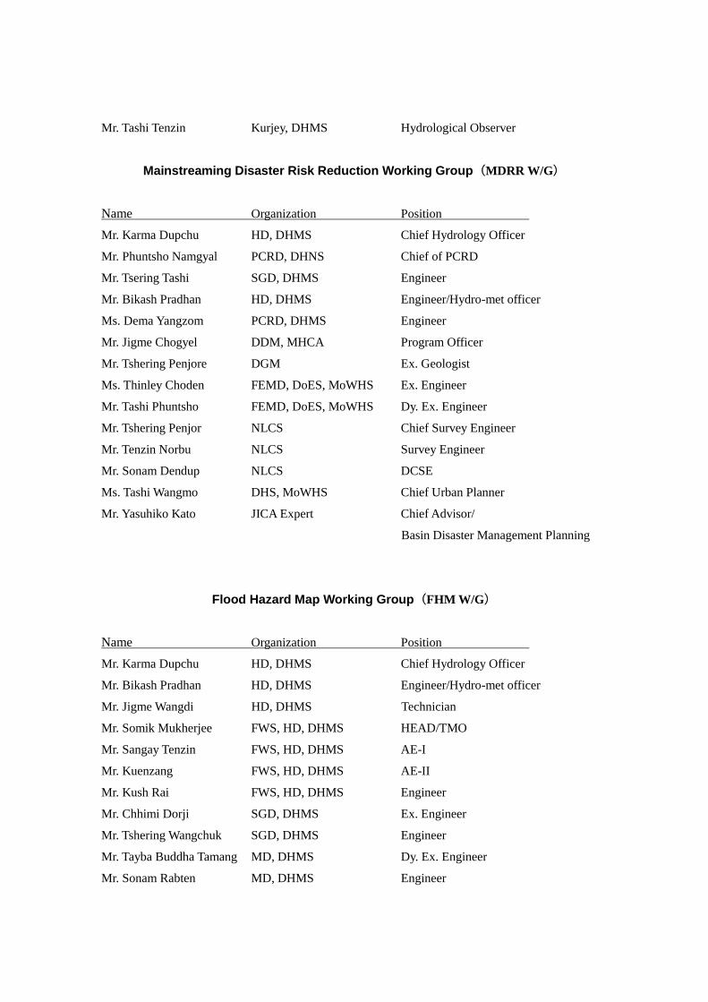
Mr. Tashi Tenzin Kurjey, DHMS Hydrological Observer
Mainstreaming Disaster Risk Reduction Working Group(MDRR W/G)
Name Organization Position
Mr. Karma Dupchu HD, DHMS Chief Hydrology Officer
Mr. Phuntsho Namgyal PCRD, DHNS Chief of PCRD
Mr. Tsering Tashi SGD, DHMS Engineer
Mr. Bikash Pradhan HD, DHMS Engineer/Hydro-met officer
Ms. Dema Yangzom PCRD, DHMS Engineer
Mr. Jigme Chogyel DDM, MHCA Program Officer
Mr. Tshering Penjore DGM Ex. Geologist
Ms. Thinley Choden FEMD, DoES, MoWHS Ex. Engineer
Mr. Tashi Phuntsho FEMD, DoES, MoWHS Dy. Ex. Engineer
Mr. Tshering Penjor NLCS Chief Survey Engineer
Mr. Tenzin Norbu NLCS Survey Engineer
Mr. Sonam Dendup NLCS DCSE
Ms. Tashi Wangmo DHS, MoWHS Chief Urban Planner
Mr. Yasuhiko Kato JICA Expert Chief Advisor/
Basin Disaster Management Planning
Flood Hazard Map Working Group(FHM W/G)
Name Organization Position
Mr. Karma Dupchu HD, DHMS Chief Hydrology Officer
Mr. Bikash Pradhan HD, DHMS Engineer/Hydro-met officer
Mr. Jigme Wangdi HD, DHMS Technician
Mr. Somik Mukherjee FWS, HD, DHMS HEAD/TMO
Mr. Sangay Tenzin FWS, HD, DHMS AE-I
Mr. Kuenzang FWS, HD, DHMS AE-II
Mr. Kush Rai FWS, HD, DHMS Engineer
Mr. Chhimi Dorji SGD, DHMS Ex. Engineer
Mr. Tshering Wangchuk SGD, DHMS Engineer
Mr. Tayba Buddha Tamang MD, DHMS Dy. Ex. Engineer
Mr. Sonam Rabten MD, DHMS Engineer
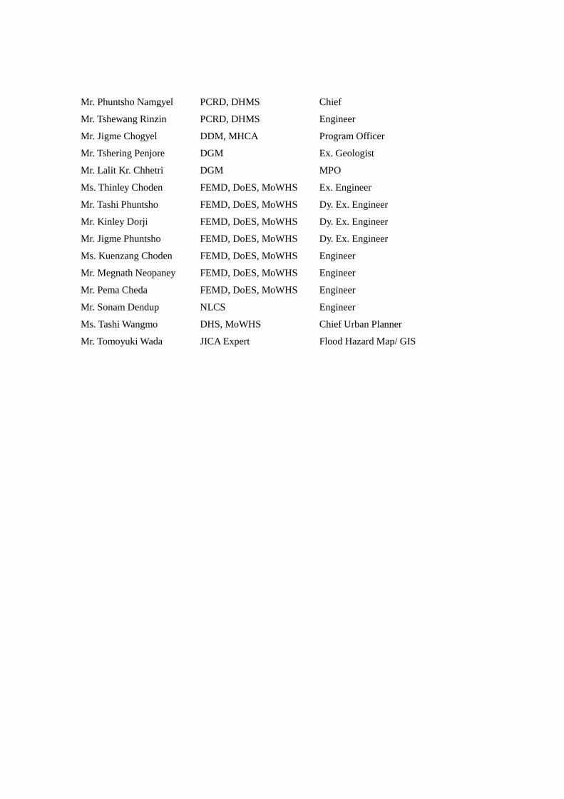
Mr. Phuntsho Namgyel PCRD, DHMS Chief
Mr. Tshewang Rinzin PCRD, DHMS Engineer
Mr. Jigme Chogyel DDM, MHCA Program Officer
Mr. Tshering Penjore DGM Ex. Geologist
Mr. Lalit Kr. Chhetri DGM MPO
Ms. Thinley Choden FEMD, DoES, MoWHS Ex. Engineer
Mr. Tashi Phuntsho FEMD, DoES, MoWHS Dy. Ex. Engineer
Mr. Kinley Dorji FEMD, DoES, MoWHS Dy. Ex. Engineer
Mr. Jigme Phuntsho FEMD, DoES, MoWHS Dy. Ex. Engineer
Ms. Kuenzang Choden FEMD, DoES, MoWHS Engineer
Mr. Megnath Neopaney FEMD, DoES, MoWHS Engineer
Mr. Pema Cheda FEMD, DoES, MoWHS Engineer
Mr. Sonam Dendup NLCS Engineer
Ms. Tashi Wangmo DHS, MoWHS Chief Urban Planner
Mr. Tomoyuki Wada JICA Expert Flood Hazard Map/ GIS

Appendix 4
Minutes of Meetings of
Inception Report

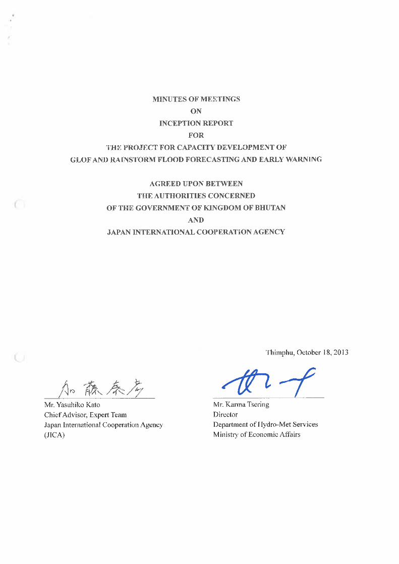


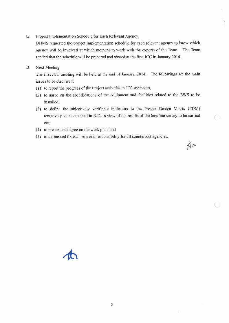


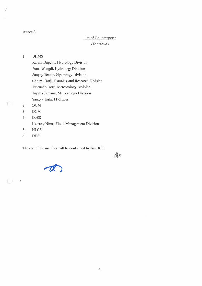


Appendix 5
Minutes of Meetings of
1st Joint Coordinating Committee
(JCC) Meeting


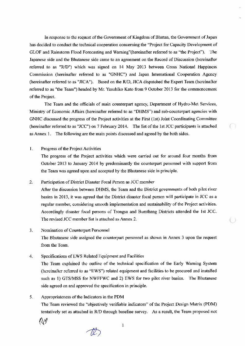
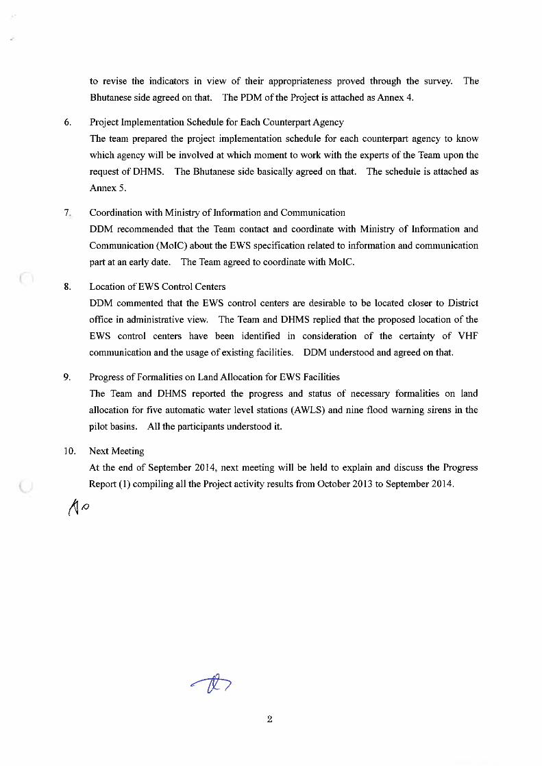

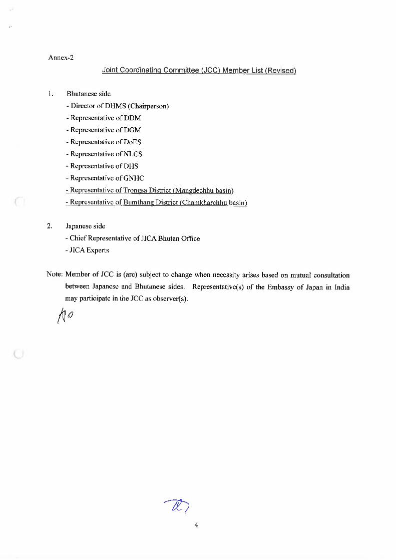
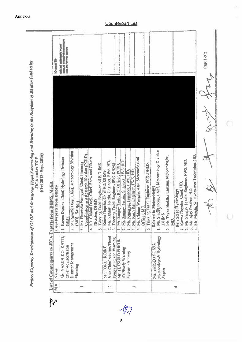


Appendix 6
Minutes of Meetings of
Progress Report (1)


Appendix 7
Minutes of Meetings of
Progress Report (2)


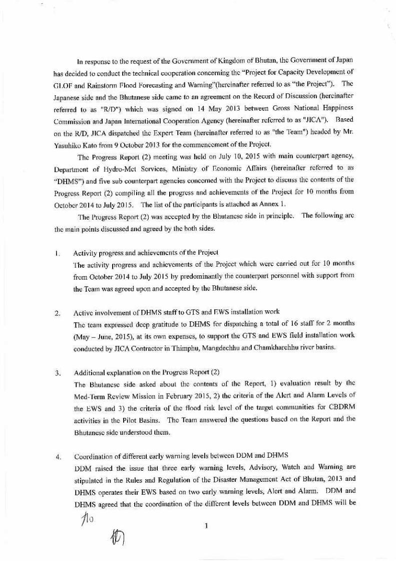
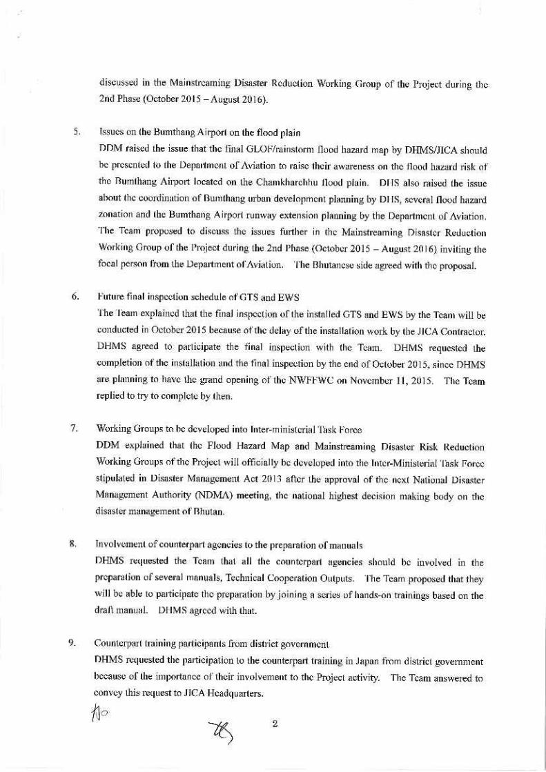


Appendix 8
Annual Seminar Program
and Participants List

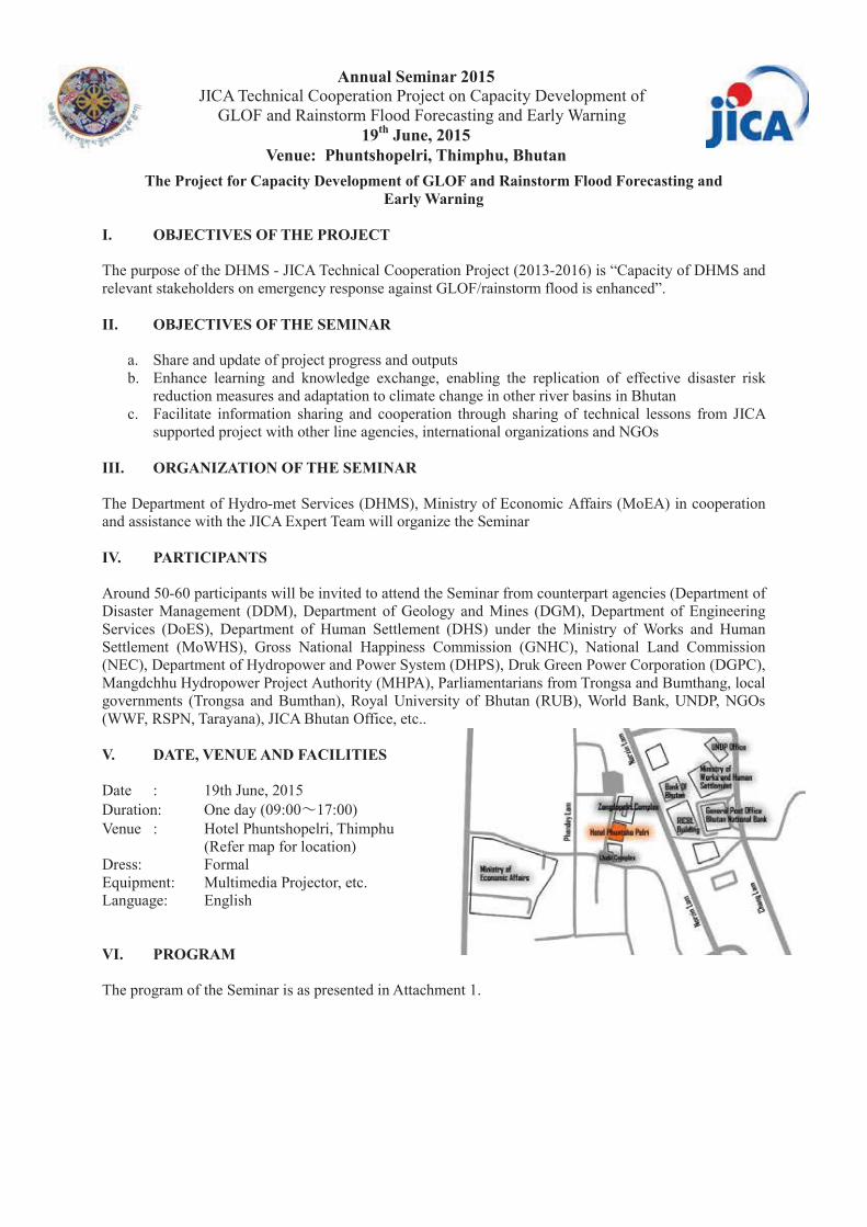
Annual Seminar 2015 JICA Technical Cooperation Project on Capacity Development of
GLOF and Rainstorm Flood Forecasting and Early Warning 19th June, 2015
Venue: Phuntshopelri, Thimphu, Bhutan The Project for Capacity Development of GLOF and Rainstorm Flood Forecasting and
Early Warning I. OBJECTIVES OF THE PROJECT The purpose of the DHMS - JICA Technical Cooperation Project (2013-2016) is “Capacity of DHMS and relevant stakeholders on emergency response against GLOF/rainstorm flood is enhanced”. II. OBJECTIVES OF THE SEMINAR
a. Share and update of project progress and outputs b. Enhance learning and knowledge exchange, enabling the replication of effective disaster risk
reduction measures and adaptation to climate change in other river basins in Bhutan c. Facilitate information sharing and cooperation through sharing of technical lessons from JICA
supported project with other line agencies, international organizations and NGOs III. ORGANIZATION OF THE SEMINAR The Department of Hydro-met Services (DHMS), Ministry of Economic Affairs (MoEA) in cooperation and assistance with the JICA Expert Team will organize the Seminar IV. PARTICIPANTS Around 50-60 participants will be invited to attend the Seminar from counterpart agencies (Department of Disaster Management (DDM), Department of Geology and Mines (DGM), Department of Engineering Services (DoES), Department of Human Settlement (DHS) under the Ministry of Works and Human Settlement (MoWHS), Gross National Happiness Commission (GNHC), National Land Commission (NEC), Department of Hydropower and Power System (DHPS), Druk Green Power Corporation (DGPC), Mangdchhu Hydropower Project Authority (MHPA), Parliamentarians from Trongsa and Bumthang, local governments (Trongsa and Bumthan), Royal University of Bhutan (RUB), World Bank, UNDP, NGOs (WWF, RSPN, Tarayana), JICA Bhutan Office, etc.. V. DATE, VENUE AND FACILITIES Date : 19th June, 2015 Duration: One day (09:00 17:00) Venue : Hotel Phuntshopelri, Thimphu (Refer map for location) Dress: Formal Equipment: Multimedia Projector, etc. Language: English VI. PROGRAM The program of the Seminar is as presented in Attachment 1.

Annual Seminar 2015 JICA Technical Cooperation Project on Capacity Development of
GLOF and Rainstorm Flood Forecasting and Early Warning 19th June, 2015
Venue: Phuntshopelri, Thimphu, Bhutan Final Agenda 09:00- 09:30 Registration 09.30 - 10:00 Arrival of Chief Guest 10:00 - 10:10 Welcome address including objective of the
Seminar Mr. Karma Tsering, Director of DHMS, MoEA
10:10- 10:20 Opening Remarks Ms. Yumiko Asakuma, Chief Representative of JICA Bhutan Office
10:20- 10:40 Keynote Address by Chief Guest His Excellency Tengye Lyonpo Norbu Wangchuk, Minister, Ministry of Economic Affairs
10: 40- 11:00 The Project on Capacity Development of GLOF and Rainstorm Flood Forecasting and Early Warning
Mr. Yasuhiko Kato, Chief Advisor, JICA Expert Team
11:00 – 11:05 Vote of thanks Mr. Karma Dupchu, Chief/Project Manager, Hydrology Division, DHMS/JICA
11:05- 11:10 Group photo 11:10- 11:20 Posters Exhibition 11:20- 11: 40 Tea/coffee break Session – I, Chair: Mr. Karma Tsering, Director, DHMS 11:40 – 12:00 Climate change impact on the Glaciers and
Glacial lakes in Bhutan Mr. Tshering Penjore, Executive Engineer of Glaciology Division, DGM, MoEA
12:00 – 12:20 NWFFWC and GLOF Early Warning System in Bhutan
Mr. Karma Dupchu, Chief/Project Manager, JICA Project, DHMS, MoEA
12:20 – 12:40 Study of Potential GLOF area in Bhutan Himalaya using GIS and Remote Sensing
Mr. Tshering, Dean Research & Industrial Linkages, College of Science and Technology
12:40 -13:00 Snow and Glacier Monitoring in Bhutan Mr. Tshering Wangchuk, SDG, DHMS 13:00 – 14:00 Lunch Session – II Chair: Hon. Nima, NC Bumthang 14:00 – 14:20 GLOF/Flood Hazard Mapping in Bumthang,
Chamkharchhu basin Mr. Bikash Pradhan, Engineer of Hydrology Division, DHMS, MoEA (Dr. Tomoyuki Wada, JICA Expert Team)
14:20 – 14:40 Disaster Risk Management Administration in Bhutan
Mr.Chador Wangdi, Director, DDM, MoHCA
14:40 – 15:00 CBDRM Activity in Bumthang, Chamkharchhu basin
Mr. Phuntsho Namgyal, Chief of Planning, Coordination & Research Division, DHMS, MoEA
15:00- 15:20 Tea/coffee break 15:20 – 15:40 Incorporating Disaster Risk Reduction into
Bumthang Urban Development Plan Ms. Tashi Wangmo, Chief Urban Planner of Survey & GIS Division, DHS, MoWHS
15:40- 16:00 Flood Engineering Management in Bhutan Mr. Tashi Phuntsho, Deputy Executive Engineer of Flood Engineering Management Division, DoES, MoWHS
16:00 – 16:30 Questions and discussion 16:30- 16:40 Closing remarks by JICA experts 16:40 -17:00 Closing remarks by Project Director/ Director DHMS
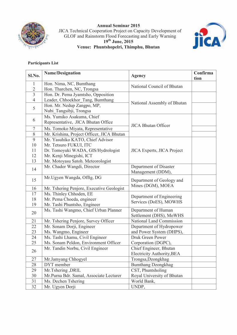
Annual Seminar 2015
JICA Technical Cooperation Project on Capacity Development of GLOF and Rainstorm Flood Forecasting and Early Warning
19th June, 2015 Venue: Phuntshopelri, Thimphu, Bhutan
Participants List
Sl.No. Name/Designation Agency Confirmation
1 2
Hon. Nima, NC, Bumthang Hon. Tharchen, NC, Trongsa National Council of Bhutan
3 4
Hon. Dr. Pema Jyamtsho, Opposition Leader, Chhoekhor_Tang, Bumthang National Assembly of Bhutan
5 Hon. Mr. Nedup Zangpo, MP, Nubi_Tangsibji, Trongsa
6 Ms. Yumiko Asakuma, Chief Representative, JICA Bhutan Office
JICA Bhutan Officer
7 Ms. Tomoko Miyata, Representative 8 Mr. Krishina, Project Officer, JICA Bhutan 9
10 11 12 13
Mr. Yasuhiko KATO, Chief Advisor Mr. Tetsuro FUKUI, ITC Dr. Tomoyuki WADA, GIS/Hydrologist Mr. Kenji Minegishi, ICT Mr. Motoyasu Satoh. Meteorologist
JICA Experts, JICA Project
14 Mr. Chador Wangdi, Director Department of Disaster Management (DDM),
15 Mr.Ugyen Wangda, Offtg, DG Department of Geology and
Mines (DGM), MOEA
16 Mr. Tshering Penjore, Executive Geologist 17 18 19
Ms. Thinley Chhoden, EE Mr. Pema Choeda, engineer Mr. Tashi Phuntsho, Engineer
Department of Engineering Services (DoES), MOWHS
20 Ms. Tashi Wangmo, Chief Urban Planner Department of Human Settlement (DHS), MoWHS
21 Mr. Tshering Penjore, Survey Officer National Land Commission 22 23
Mr. Sonam Dorji, Engineer Ms. Wangmo, Engineer
Department of Hydropower and Power System (DHPS),
24 25
Ms. Tashi Lhamu, Civil Engineer Ms. Sonam Peldon, Environment Officer
Druk Green Power Corporation (DGPC),
26 Mr. Tandin Norbu, Civil Engineer Chief Engineer, Bhutan Electricity Authority,BEA
27 Mr.Jamyang Chhogyel Trongsa,Dzongkhag 28 DYT member Bumthang Dzongkhag 29 30
Mr.Tshering ,DRIL Mr.Purna Bdr. Samal, Associate Lecturer
CST, Phuntsholing Royal University of Bhutan
31 Ms. Dechen Tshering World Bank, 32 Mr. Ugyen Dorji UNDP,

Annual Seminar 2015
JICA Technical Cooperation Project on Capacity Development of GLOF and Rainstorm Flood Forecasting and Early Warning
19th June, 2015 Venue: Phuntshopelri, Thimphu, Bhutan
33 Mr.Tashi Dawa, Project Manager RSPN
34 Ms. Nagderl Lhamo WWF
35 Mr.Jamyang Phuntsho Tarayana
36 Mr. Trashi Penjore, Legal Officer PPD, MOEA 37 Mr. Karma Tsering, Director, DHMS DHMS, MOEA 38 39 40 41 42 43
Mr. Karma Dupchu, Chief, Mr. Somik Mukherjee, TMO Mr. Pashupati Sharma, Ex. Engineer Mr.Pema Wangdi, Asst. Engineer Mr. Sangay Tenzin, Engineer Mr. Kush Rai, Asst. Engineer
Hydrology Division, DHMS
44 45 46
Mr.Thaba Tamang, Offtg. Chief Mr. Kuenzang Sonam, Dy. Chief Mr. Sonam Rabten, Engineer
Meteorology Division, DHMS
47 48 49
Mr. Phuensho Namgyal, Offtg. Chief Mr.Tashi Namgay, Engineer Mr.Tshewang Rinzin, Engineer
Planning Coordination and Research Division (PCRD), DHMS
50 51
Mr. Tshering Wangchuk, Engineer Ms. Jamyang Choden, Engineer
Snow and glacier Division (SGD), DHMS
52 Mr. M.B Subba Kuensel 53 Mr. Sonam Ugen BBS
Total

Annual Seminar 2016 JICA Technical Cooperation Project on Capacity Development of
GLOF and Rainstorm Flood Forecasting and Early Warning 14th June, 2016
Venue: Le Meridien, Thimphu, Bhutan I. OBJECTIVES OF THE PROJECT The purpose of the DHMS - JICA Technical Cooperation Project (2013-2016) is “Capacity of DHMS and relevant stakeholders on emergency response against GLOF/rainstorm flood is enhanced”. II. OBJECTIVES OF THE SEMINAR
a. Share and update of project achievement b. Enhance learning and knowledge exchange, enabling the replication of effective disaster risk
reduction measures and adaptation to climate change in other river basins in Bhutan c. Facilitate information sharing and cooperation through sharing of technical lessons from JICA
supported project with other line agencies, international organizations and NGOs III. ORGANIZATION OF THE SEMINAR The Department of Hydro-met Services (DHMS), Ministry of Economic Affairs (MoEA)in cooperation and assistance with the JICA Expert Team will organize the Seminar IV. PARTICIPANTS Around 50-60 participants will be invited to attend the Seminar from counterpart agencies (Department of Disaster Management (DDM), Department of Geology and Mines (DGM), Department of Engineering Services (DoES), Department of Human Settlement (DHS) under the Ministry of Works and Human Settlement (MoWHS), National Land Commission (NLC), Gross National Happiness Commission (GNHC), Department of Hydropower and Power System (DHPS), Druk Green Power Corporation (DGPC),Mangdechhu Hydropower Project Authority (MHPA), Parliamentarians from Trongsa and Bumthang, local governments (Trongsa and Bumthang), World Bank, UNDP, NGOs (WWF, RSPN, Tarayana), JICA Bhutan Office, etc.. V. DATE, VENUE AND FACILITIES Date : 14th June, 2016 Duration: One day (08:00 17:00) Venue : Le Meridien (Chorten Lam,Thimphu) Dress: Formal Equipment: Multimedia Projector, etc. Language: English VI. PROGRAM The program of the Seminar is as presented in Attachment 1.

Annual Seminar 2016 JICA Technical Cooperation Project on Capacity Development of
GLOF and Rainstorm Flood Forecasting and Early Warning 14th June, 2016
Venue: Le Meridien, Thimphu, Bhutan Tentative Final Agenda 08:00- 08:30 Registration 08.30 - 09:00 Arrival of Chief Guest
09:00 - 09:15 Welcome address including objective of the Seminar
Mr. Karma Tsering, Director of DHMS, MoEA
09:15- 09:30 Opening Remarks Mr. Koji Yamada,Chief Representative of JICA Bhutan Office
09:30- 09:45 Keynote Address by Chief Guest His Excellency Lyonpo Lekey Dorji. Minister, Ministry of Economic Affairs
09: 45- 10:00 The Achievement of the JICA Technical Cooperation Project
Mr. Yasuhiko Kato, Chief Advisor, JICA Expert Team
10:00- 10:05 Launching of Hydrological Data Book
10:05 – 10:10 Vote of Thanks Mr. Karma Dupchu, Chief/Project Manager, Hydrology Division, DHMS/JICA
10:10- 10:20 Group Photo 10:20 - 10:45 Posters Exhibition 10:45- 11: 10 Tea/coffee break Session – I, Chair: to be determined
11:10 – 11:40 Potential Risk of GLOF in Mangdechhu and Chamkharchhu River Basins
Mr. Karma Tsering, Director of DHMS, MoEA
11:40 – 12:10 Outline of the GLOF/ Rainstorm Flood Early Warning System (EWS) in Mangdechhu and Chamkharchhu Basins in NWFWC, DHMS
Mr. Karma Dupchu, Chief/Project Manager, JICA Project, DHMS, MoEA
12:10 – 12:30 Communication System of GLOF/Rainstorm Flood Early Warning System in Mangdechhu and Chamkharchhu Basins
Mr. Kuenzang, Engineer, Hydrology Division, DHMS, MoEA
12:30 – 12:50 Outline of the Global Telecommunication System (GTS) / Message Switching System (MSS) and HimawariCast in NWFWC, DHMS
Mr. Tayba Buddha Tamang, Senior Meteorologist, Meteorology Division, DHMS, MoEA
12:50 – 14:00 Lunch Session – II Chair: to be determined
14:00 -14:20 Flood Forecasting using IFAS and HBV Model for Mochhu and Chamkharchhu sub-basins
Mr.Bikash Pradhan/Mr. Pema Wangdi, Engineer, Hydrology Division, DHMS, MOEA
14:20 – 14:40 Flood Modelling of Dungsamchu, SamdrupJongkhar
Mr. Cheten Dorji/ Mr. Tashi Phuntsho, Deputy Executive Engineer of Flood Engineering Management Division, DoES, MoWHS
14:40 – 15:00 Evacuation Planning and Drill in Bumthang using the EWS in Chamkharchhu River Basin
Mr. Phuntsho Namgyal, Chief of Planning, Coordination & Research Division, DHMS, MoEA
15:00 – 15:20
Development of the Standard Operation Procedure (SOP) for GLOF/ Rainstorm Flood in Mangdechhu and Chamkharchhu River Basins
Mr. Toru Koike, Vice Chief Advisor, JICA Expert Team

Annual Seminar 2016 JICA Technical Cooperation Project on Capacity Development of
GLOF and Rainstorm Flood Forecasting and Early Warning 14th June, 2016
Venue: Le Meridien, Thimphu, Bhutan
15:20 - 15:35 Tea/coffee break
15:35 – 16:00 Course of Action in Establishing Central and District Emergency Operation Centres (EOC)
Mr. Chador Wangdi, Director, DDM, MoHCA
16:00 – 16:20 Mainstreaming Disaster Risk Reduction into Urban Planning in Bhutan
Ms. Tashi Wangmo, Chief Urban Planner, Survey & GIS Division, DHS, MoWHS
16:20 – 16:40 Questions and discussion 16:40– 16:50 Closing remarks by JICA Experts 16:50 –17:00 Closing remarks by Project Director/ Director DHMS
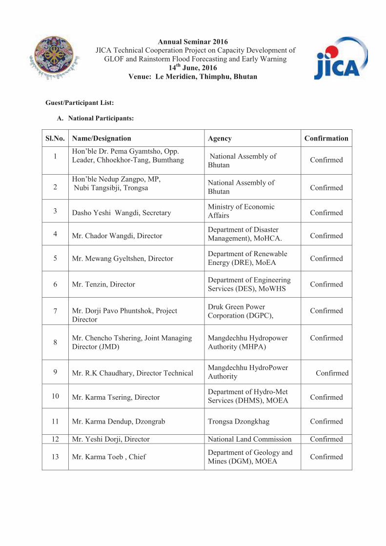
Annual Seminar 2016
JICA Technical Cooperation Project on Capacity Development of GLOF and Rainstorm Flood Forecasting and Early Warning
14th June, 2016 Venue: Le Meridien, Thimphu, Bhutan
Guest/Participant List:
A. National Participants:
Sl.No. Name/Designation Agency Confirmation
1
Hon’ble Dr. Pema Gyamtsho, Opp. Leader, Chhoekhor-Tang, Bumthang National Assembly of
Bhutan
Confirmed
2 Hon’ble Nedup Zangpo, MP, Nubi Tangsibji, Trongsa
National Assembly of Bhutan
Confirmed
3 Dasho Yeshi Wangdi, Secretary
Ministry of Economic Affairs
Confirmed
4 Mr. Chador Wangdi, Director
Department of Disaster Management), MoHCA.
Confirmed
5 Mr. Mewang Gyeltshen, Director Department of Renewable
Energy (DRE), MoEA
Confirmed
6 Mr. Tenzin, Director
Department of Engineering Services (DES), MoWHS
Confirmed
7 Mr. Dorji Pavo Phuntshok, Project Director
Druk Green Power Corporation (DGPC),
Confirmed
8
Mr. Chencho Tshering, Joint Managing Director (JMD)
Mangdechhu Hydropower Authority (MHPA)
Confirmed
9 Mr. R.K Chaudhary, Director Technical
Mangdechhu HydroPower Authority
Confirmed
10 Mr. Karma Tsering, Director
Department of Hydro-Met Services (DHMS), MOEA
Confirmed
11 Mr. Karma Dendup, Dzongrab
Trongsa Dzongkhag
Confirmed
12 Mr. Yeshi Dorji, Director National Land Commission Confirmed
13 Mr. Karma Toeb , Chief
Department of Geology and Mines (DGM), MOEA
Confirmed

Annual Seminar 2016
JICA Technical Cooperation Project on Capacity Development of GLOF and Rainstorm Flood Forecasting and Early Warning
14th June, 2016 Venue: Le Meridien, Thimphu, Bhutan
14 Mr. Karma Dupchu, Chief
Hydrology Division, Department of Hydro-Met Services, MoEA
Confirmed
15
Ms. Tashi Wangmo, Chief
Department of Human Settlement (DHS), MoWHS
Confirmed
16
Ms. Dago Zangmo, Chief
Department of Engineering Services (DES), MoWHS
Confirmed
17
Mr. Phuetsho Namgyal, Chief
Planning Coordination and Research Division, Department of Hydro-Met Services, MoEA
Confirmed
18 Mr.Tayba BuddhaTamang, Offtg. Chief
Meteorology Division, DHMS, MoEA
Confirmed
19
Mr. Tshering Tashi, Offtg. Chief Snow and glacier Division
(SGD), DHMS, MoEA
Confirmed
20
Mr. Cheten Dorji, Chief Engineer
Department of Engineering Services (DES), MoWHS
Confirmed
21
Mr.
National Environment Commission Secretariat.
22
Mr. Dr. Om Katel, Lecturer Royal University of Bhutan
Confirmed
23 Mr. Tenzin Norbu, Chief National Land Commission
Confirmed
24 Ms. Wangmo, Engineer
Department of Hydropower and Power System (DHPS), MoEA
Confirmed
25 Mr. Yang Dorji, Department of School Education, MoE Confirmed
26 Mr. Pratigya Pradhan, Engineer
Druk Green Power Corporation (DGPC)
Confirmed
27 Ms. Tshering Choki, Project Officer
Royal Society for Protection of Nature (RSPN)
Confirmed
28 Ms. Nagderl Lhamo World Wildlife Fund (WWF)
Confirmed
29 Mr. Sonam Dargay Confirmed
30 Mr. Sandeepp Rai, General Manager Bhutan Power Corporation
Liminted
Confirmed

Annual Seminar 2016
JICA Technical Cooperation Project on Capacity Development of GLOF and Rainstorm Flood Forecasting and Early Warning
14th June, 2016 Venue: Le Meridien, Thimphu, Bhutan
31 Ms. Kezang Dema, Assistant Engineer
Mangdechu Hydropower Authority (MHPA)
Confirmed
32 Ms. Sunita Neopaney, Assistant Engineer
Confirmed
33 Ms. Alisha Rai, Assistant Engineer
Confirmed
34 Mr. Karma Jamtsho, Assistant Engineer
Confirmed
35 Mr. Sonam Gyeltshen, Assistant Engineer
Confirmed
36 Mr. Namgay, Research Officer
Confirmed
37 Mr. Jamyang Chojay, Disaster Focal Person Trongsa Dzongkhag
Confirmed
38 Mr. Ugyen Dorji, Human Resource Officer Bumthang Dzongkhag
Confirmed
39 Mr. Somik Mukherjee, TMO
Hydrology Division, Department of Hydro-Met Services, MoEA
Confirmed
39 Mr. Dhendup Tshering, Principal Engineer
Confirmed
40 Mr. Pashupati Sharma, Ex. Engineer
Confirmed
41 Mr. Pema Wangdi, Asst. Engineer
Confirmed
42 Mr. Sangay Tenzin, Engineer
Confirmed
42 Mr. Kush Rai, Asst. Engineer
Confirmed
43 Mr. Bikash Pradhan, Engineer
Confirmed
44 Mr. Tandin Wangchuk, Engineer
Confirmed
45 Mr. Cheki Dorji, Engineer Meteorology Division, Department of Hydro-Met Services, MoEA
Confirmed
46 Mr. Pema Syelden, Engineer Confirmed
47 Mr. Chimmi Wangda, Data Manager Confirmed
48 Mr. Pema Wangyal, Engineer Planning Coordination and
Research Division, Department of Hydro-Met Services, MoEA
Confirmed
49 Mr. Ugyen Chophel, Statistician Confirmed
50 Mr. Tashi Phuntsho Engineer
Department of Engineering Services (DES), MoWHS
Confirmed

Annual Seminar 2016
JICA Technical Cooperation Project on Capacity Development of GLOF and Rainstorm Flood Forecasting and Early Warning
14th June, 2016 Venue: Le Meridien, Thimphu, Bhutan
51 Mr. Sonam Lhendup, Planning Officer Policy and Planning
Division, Ministry of Economic Affairs
Confirmed
52 Mr. Krishna Subba, JICA Bhutan Office
Confirmed
53 Mr. Tshering Peldon
Kuensel
Confirmed
54 Mr. Ashok Tiwari
BBS Confirmed
B. International Guests:
1 Mr. Koji YAMADA, Chief Representative Japan International
Cooperation Agency (JICA)
Confirmed
2
Mr. Tomoko MIYATA, In charge of the Project
Confirmed
3 4
5 6
Mr. Yasuhiko KATO, Chief Advisor Mr. Junya Yamaguchi, Chief Adviser of the TCP Mr. Torus KOIKE, Vice Chief Advisor Mr. Kenji MINEGISHI, ICT
JICA Experts, JICA Project
Confirmed
6 Mr. Nimah Challier Smith, Dy. Resident Representative
United Nations Development Programme (UNDP)
Confirmed
7 Dr. Nima WANGCHUK WHO Country Office for Bhutan
Confirmed
C. Supporting Staff
1 Mr. Ajay Pradhan, Data Assistant Hydrology Division, DHMS, MoEA
2 Mr. Manila, Sr. Technician 3 Ms. Thinley Gyem, Adm. Assistant 4 Ms. Pasang Gem, Data Assistant


Appendix 9
Program of Debrief Session on C/P
Trainings in Japan

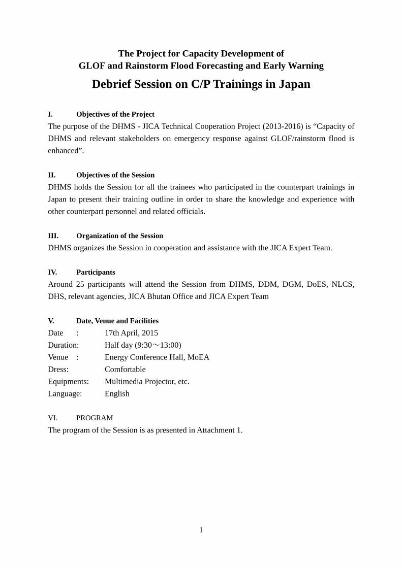
1
The Project for Capacity Development of GLOF and Rainstorm Flood Forecasting and Early Warning
Debrief Session on C/P Trainings in Japan I. Objectives of the Project The purpose of the DHMS - JICA Technical Cooperation Project (2013-2016) is “Capacity of DHMS and relevant stakeholders on emergency response against GLOF/rainstorm flood is enhanced”. II. Objectives of the Session DHMS holds the Session for all the trainees who participated in the counterpart trainings in Japan to present their training outline in order to share the knowledge and experience with other counterpart personnel and related officials. III. Organization of the Session DHMS organizes the Session in cooperation and assistance with the JICA Expert Team. IV. Participants Around 25 participants will attend the Session from DHMS, DDM, DGM, DoES, NLCS, DHS, relevant agencies, JICA Bhutan Office and JICA Expert Team V. Date, Venue and Facilities Date : 17th April, 2015 Duration: Half day (9:30~13:00) Venue : Energy Conference Hall, MoEA Dress: Comfortable Equipments: Multimedia Projector, etc. Language: English VI. PROGRAM
The program of the Session is as presented in Attachment 1.
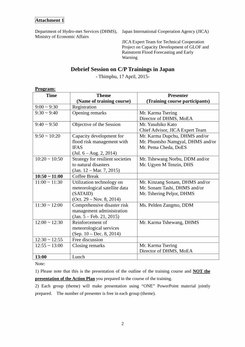
Attachment 1
2
Department of Hydro-met Services (DHMS), Ministry of Economic Affairs
Japan International Cooperation Agency (JICA)
JICA Expert Team for Technical Cooperation Project on Capacity Development of GLOF and Rainstorm Flood Forecasting and Early Warning
Debrief Session on C/P Trainings in Japan - Thimphu, 17 April, 2015-
Program:
Time Theme (Name of training course)
Presenter (Training course participants)
9:00 ~ 9:30 Registration 9:30 ~ 9:40 Opening remarks Mr. Karma Tsering
Director of DHMS, MoEA 9:40 ~ 9:50 Objective of the Session Mr. Yasuhiko Kato
Chief Advisor, JICA Expert Team 9:50 ~ 10:20 Capacity development for
flood risk management with IFAS (Jul. 6 – Aug. 2, 2014)
Mr. Karma Dupchu, DHMS and/or Mr. Phuntsho Namgyal, DHMS and/or Mr. Pema Cheda, DoES
10:20 ~ 10:50 Strategy for resilient societies to natural disasters (Jan. 12 – Mar. 7, 2015)
Mr. Tshewang Norbu, DDM and/or Mr. Ugyen M Tenzin, DHS
10:50 ~ 11:00 Coffee Break 11:00 ~ 11:30 Utilization technology on
meteorological satellite data (SATAID) (Oct. 29 – Nov. 8, 2014)
Mr. Kinzang Sonam, DHMS and/or Mr. Sonam Tashi, DHMS and/or Mr. Tshering Peljor, DHMS
11:30 ~ 12:00 Comprehensive disaster risk management administration (Jan. 5 – Feb. 21, 2015)
Ms. Pelden Zangmo, DDM
12:00 ~ 12:30 Reinforcement of meteorological services (Sep. 10 – Dec. 8, 2014)
Mr. Karma Tshewang, DHMS
12:30 ~ 12:55 Free discussion 12:55 ~ 13:00 Closing remarks Mr. Karma Tsering
Director of DHMS, MoEA 13:00 Lunch Note: 1) Please note that this is the presentation of the outline of the training course and NOT the presentation of the Action Plan you prepared in the course of the training. 2) Each group (theme) will make presentation using “ONE” PowerPoint material jointly prepared. The number of presenter is free in each group (theme).
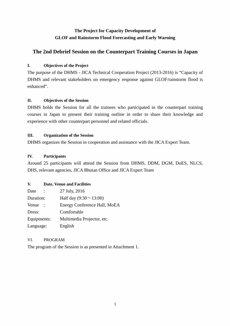
1
The Project for Capacity Development of GLOF and Rainstorm Flood Forecasting and Early Warning
The 2nd Debrief Session on the Counterpart Training Courses in Japan
I. Objectives of the Project The purpose of the DHMS - JICA Technical Cooperation Project (2013-2016) is “Capacity of DHMS and relevant stakeholders on emergency response against GLOF/rainstorm flood is enhanced”. II. Objectives of the Session DHMS holds the Session for all the trainees who participated in the counterpart training courses in Japan to present their training outline in order to share their knowledge and experience with other counterpart personnel and related officials. III. Organization of the Session DHMS organizes the Session in cooperation and assistance with the JICA Expert Team. IV. Participants Around 25 participants will attend the Session from DHMS, DDM, DGM, DoES, NLCS, DHS, relevant agencies, JICA Bhutan Office and JICA Expert Team V. Date, Venue and Facilities Date : 27 July, 2016 Duration: Half day (9:30~13:00) Venue : Energy Conference Hall, MoEA Dress: Comfortable Equipments: Multimedia Projector, etc. Language: English VI. PROGRAM
The program of the Session is as presented in Attachment 1.
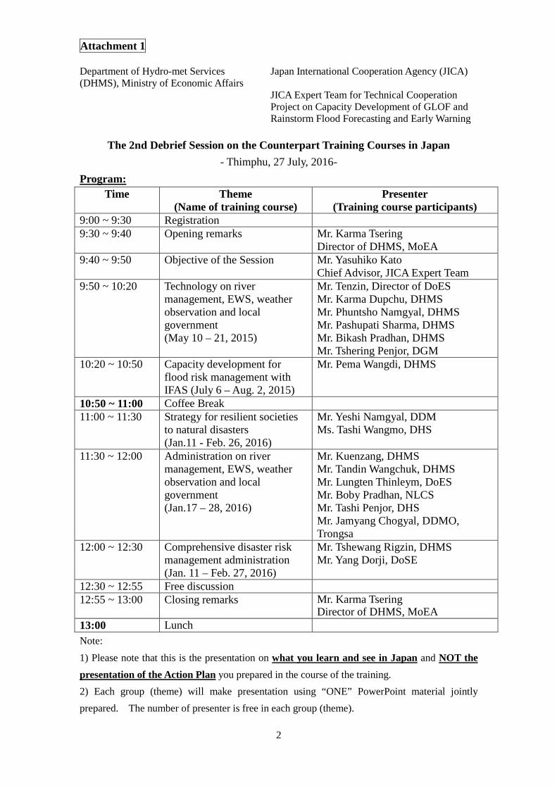
Attachment 1
2
Department of Hydro-met Services (DHMS), Ministry of Economic Affairs
Japan International Cooperation Agency (JICA)
JICA Expert Team for Technical Cooperation Project on Capacity Development of GLOF and Rainstorm Flood Forecasting and Early Warning
The 2nd Debrief Session on the Counterpart Training Courses in Japan
- Thimphu, 27 July, 2016- Program:
Time Theme (Name of training course)
Presenter (Training course participants)
9:00 ~ 9:30 Registration 9:30 ~ 9:40 Opening remarks Mr. Karma Tsering
Director of DHMS, MoEA 9:40 ~ 9:50 Objective of the Session Mr. Yasuhiko Kato
Chief Advisor, JICA Expert Team 9:50 ~ 10:20 Technology on river
management, EWS, weather observation and local government (May 10 – 21, 2015)
Mr. Tenzin, Director of DoES Mr. Karma Dupchu, DHMS Mr. Phuntsho Namgyal, DHMS Mr. Pashupati Sharma, DHMS Mr. Bikash Pradhan, DHMS Mr. Tshering Penjor, DGM
10:20 ~ 10:50 Capacity development for flood risk management with IFAS (July 6 – Aug. 2, 2015)
Mr. Pema Wangdi, DHMS
10:50 ~ 11:00 Coffee Break 11:00 ~ 11:30 Strategy for resilient societies
to natural disasters (Jan.11 - Feb. 26, 2016)
Mr. Yeshi Namgyal, DDM Ms. Tashi Wangmo, DHS
11:30 ~ 12:00 Administration on river management, EWS, weather observation and local government (Jan.17 – 28, 2016)
Mr. Kuenzang, DHMS Mr. Tandin Wangchuk, DHMS Mr. Lungten Thinleym, DoES Mr. Boby Pradhan, NLCS Mr. Tashi Penjor, DHS Mr. Jamyang Chogyal, DDMO, Trongsa
12:00 ~ 12:30 Comprehensive disaster risk management administration (Jan. 11 – Feb. 27, 2016)
Mr. Tshewang Rigzin, DHMS Mr. Yang Dorji, DoSE
12:30 ~ 12:55 Free discussion 12:55 ~ 13:00 Closing remarks Mr. Karma Tsering
Director of DHMS, MoEA 13:00 Lunch Note: 1) Please note that this is the presentation on what you learn and see in Japan and NOT the presentation of the Action Plan you prepared in the course of the training. 2) Each group (theme) will make presentation using “ONE” PowerPoint material jointly prepared. The number of presenter is free in each group (theme).

Appendix 10
Minutes of Meetings of Flood
Hazard Map Working Group
Workshops


The Project for Capacity Development of GLOF and Rainstorm Flood Forecasting and Early Warning
in the Kingdom of Bhutan
JICA Expert Team February 12, 2014
Memorandum 1st Meeting of FHM Working Group
Purpose of the W/G The purpose and function of the W/G was explained by Mr. Karma Dupchu, PM and JICA experts.
► Mr. Koike presented the institutions and regulations on FHM in Japan. ► The FHMs in Japan are prepared by a strong initiative of Ministry of Land, Infrastructure,
Transportation and Truism (MLIT). In Bhutan, however, the necessary functions such as river monitoring, flood protection works, geomorphological survey, Land use, etc… are dispersed to the individual agencies. Therefore preparation of FHM is inter-ministerial issues.
► W/G members remarked that the Inter-Ministerial Task Force will be formulated according to the National Disaster Prevention Act 2013. The guideline and manual developed by the W/G shall be referred by Inter-Ministerial T/F when launched.
Concept of Flood Zonation Mapping The basic flow and overall schedule for flood hazard zonation mapping were presented by Dr. Wada. In the project, IFAS and iRIC (or HEC-RAS) will be employed for runoff modeling and flood analysis respectively. In addition,the following technical issues were discussed:
► Difference between ArcGIS and Quantum GIS ► Functions of IFAS program and parameters ► Risk assessment in the training
Activities and Meeting Ahead ► It was suggested by W/G members that it is not
necessary to issue official letters to hold the W/G meetings. The project directly informs to W/G members by email. The date of meeting should be announced before 1 week so that W/G member could arrange the schedule.
► Dr. Wada demonstrates GPS survey in Thimphu in February. The expected date will be informed to the participants.
► The FHM related information should be shared within the W/G. Therefore each agency were requested to present their own field in the next meeting. The detail will be requested from JICA experts.
1st Meeting at DHMS

The Project for Capacity Development of GLOF and Rainstorm Flood Forecasting and Early Warning
in the Kingdom of Bhutan
JICA Expert Team April 30, 2014
Memorandum 2nd Meeting of FHM Working Group
Today’s topics 1. Presentation from Mr. Tashi Phuntsho about objective and mandates of Flood
Engineering Management Division, Department of Engineering Services 2. Short report about GPS/Total Station survey in Bumthang and Bjizam
Place and period: Bumthang 3/25-29, Bjizam 3/30 3. Schedule of FHM training (in end of June)
Steps of basic runoff and flood analysis training
i. Data preparing ---- 2 days ii. Runoff analysis ---- 1 day
(runoff analysis by IFAS, calculated discharge will be utilized on flood analysis) iii. Flood analysis ---- 2 days
(flood analysis by HEC-RAS and iRIC) 1D model to estimate water stage of river channel / 2D model to detect inundation area and water level
iv. Plotting calculated flood area on settlement data ---- 1 day Comments and discussion by the participants FEMD and DHMS has similar plan to build runoff model. However, the objective is
different (FEMD: for structural countermeasure, DHMS: for extensive purpose such as flood warning)
Balance of bank protection and environmental conservation is important. As an example in japan, three side protections (river banks and bed) is utilized as one of effective structural countermeasure, but this technique causes severe impacts on living environment of aquatic organism and fishes. Countermeasure selection taking into account environmental effect is necessary.
Embankment in the Bumthang town is bored for easy river access. Awareness activity for local people is important to improve their mind for disaster management.
River bank erosion occurs at some part of farming land beside the Chamkharchhu. Some road side gabions are also damaged along the Chamkharchhu.
Countermeasure is needed to protect them from river erosion.

The Project for Capacity Development of GLOF and Rainstorm Flood Forecasting and Early Warning
in the Kingdom of Bhutan
JICA Expert Team Oct 7, 2014
Memorandum 3rd Meeting of FHM Working Group
Today’s topics Discussion about draft flood hazard maps in Chamkharchhu and Mangdechhu river basin Flood hazard map (GLOF scenario) in Bumthang valley (left) and Bjizam (right)
Comments and discussion by the participants The draft flood hazard maps prepared by hydrological methods are introduced to FHM W/G
members. At the beginning, overall analysis in Chamkharchhu basin (from glacial lake to
Bumthang valley) and Mangdechhu basin (from glacial lake to the hydropower plant site)
were shown to the members. Subsequently, the detailed hazard maps in Bumthang,
Choekhor Toe, Kagthang and Bjizam villages were explained.
DHS is preparing the development plan in Bumthang valley based on hazard maps
prepared by DHS and DGM. The development plan contains relocation and development
protection in the risk area. However, there are small risk area difference between the
DHS/DGM flood hazard maps and ours. We need to discuss which map we should use for
the plan.
Past flood records must be shown in the flood hazard maps. Such kind of information is
important for local people and judging the reasonability of the analysis.
After finalizing the flood hazard maps, it might be better to explain the maps to the Directors
before the maps will be published.
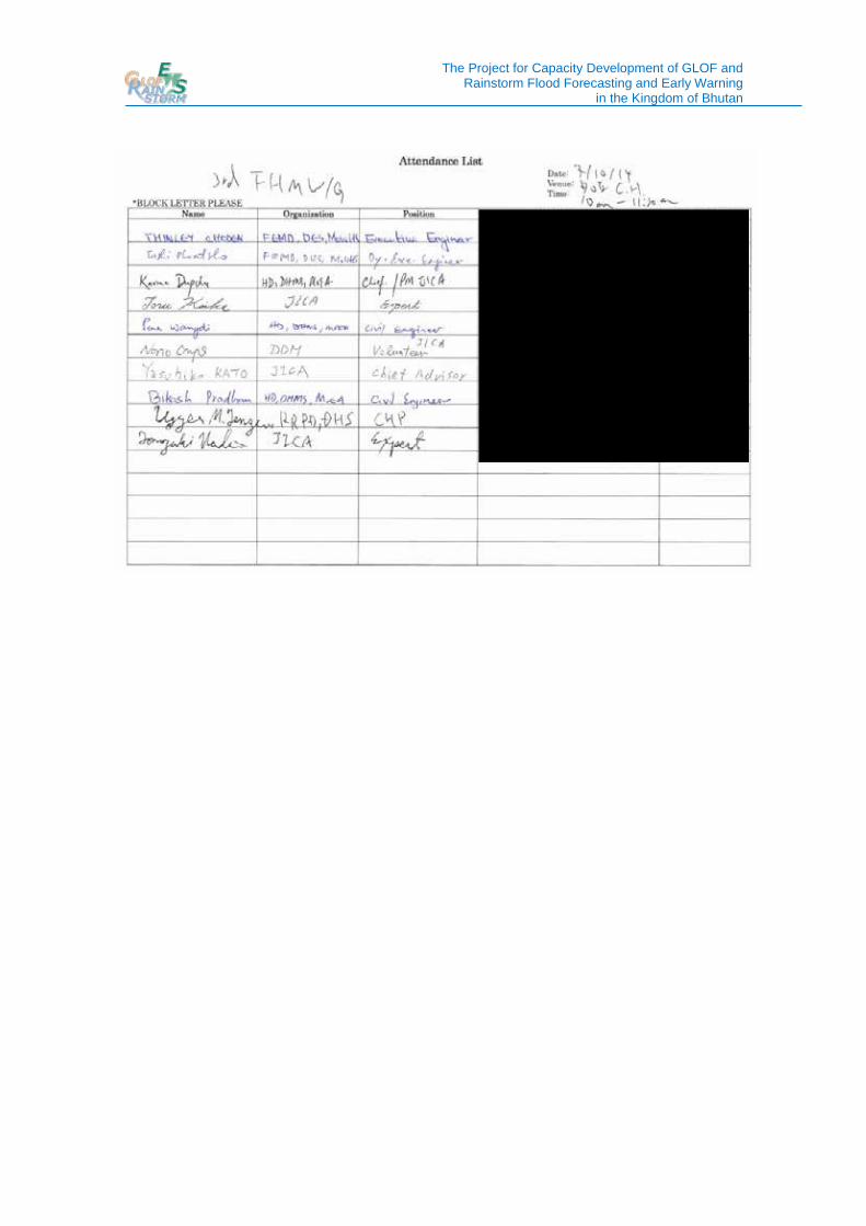
The Project for Capacity Development of GLOF and Rainstorm Flood Forecasting and Early Warning
in the Kingdom of Bhutan

The Project for Capacity Development of GLOF and Rainstorm Flood Forecasting and Early Warning
in the Kingdom of Bhutan
JICA Expert Team Feb 25, 2015
Memorandum 4th Meeting of FHM Working Group
Today’s topics Finalization of flood hazard maps in Chamkharchhu and Mangdechhu river basin Flood hazard map (GLOF scenario) in Bumthang valley (left) and comparison between the simulated flood area and the protected area of DHS development plan (right)
Comments and discussion by the participants The past maximum rainstorm flood (Cyclone Aila) and GLOF scenarios are selected for
flood hazard maps in the project area. (Peak discharge) 100yrs return period < past max. (Aila) < GLOF (Possibility) 100yrs return period > past max. (Aila) > GLOF?
We can use those flood hazard maps as basic information when the Government of Bhutan
makes development plans or conducts disaster risk management activities.
The government should discuss which scenario is suitable for development plan making,
considering balance of countermeasure costs, preservation property and possibility of the
flood.
If the detail of the preservation property in the risk area could be evaluated, the information
must be helpful for the government decision making.
There is a difference between the simulated flood area and the protected area of DHS
development plan near Bathpalathang airport. Discussion is necessary to solve this issue.
The flood hazard maps should be introduced to Dzongkhag officers.
Japanese standard of flood risk classification (-0.5m: underfloor flooding, 0.5-3.0m:
over-floor flooding, 3.0m-: upstairs or higher floor flooding) is also suitable in Bhutan.

The Project for Capacity Development of GLOF and Rainstorm Flood Forecasting and Early Warning
in the Kingdom of Bhutan

The Project for Capacity Development of GLOF and Rainstorm Flood Forecasting and Early Warning
in the Kingdom of Bhutan
JICA Expert Team March, 2016
Memorandum 5th Meeting of FHM Working Group
Today’s Topics
1. Flood Hazard Map (FHM) preparation manual
- The draft FHM preparation manual was shared among the members. The manual would be updated considering comments from the members.
- Roles of relevant agencies and flow of FHM preparation was discussed. 2. Schedule of the next runoff/flood analysis training and target areas 3. Application of the FHM for other sector activities (invite new member from road sector,
Department of Road, as an end user of flood hazard maps)
- FHM is helpful information for structure design works. Thus, Department of Road, MoWHS, was invited as a new member of W/G.
- Examples of flood risk evaluation by flood analysis are introduced to the members and discussed.
Example of flood simulation result at vulnerable point of national highway

The Project for Capacity Development of GLOF and Rainstorm Flood Forecasting and Early Warning
in the Kingdom of Bhutan
Appendix 11
Minutes of Meetings of
Mainstreaming Disaster Risk
Reduction Working Group
Workshops

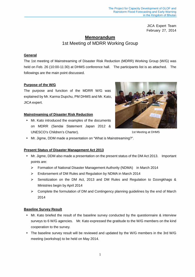
The Project for Capacity Development of GLOF and Rainstorm Flood Forecasting and Early Warning
in the Kingdom of Bhutan
1
JICA Expert Team February 27, 2014
Memorandum 1st Meeting of MDRR Working Group
General The 1st meeting of Mainstreaming of Disaster Risk Reduction (MDRR) Working Group (W/G) was held on Feb. 26 (10:00-11:30) at DHMS conference hall. The participants list is as attached. The followings are the main point discussed.
Purpose of the W/G The purpose and function of the MDRR W/G was explained by Mr. Karma Dupchu, PM DHMS and Mr. Kato, JICA expert.
Mainstreaming of Disaster Risk Reduction ► Mr. Kato introduced the examples of the documents
on MDRR (Sendai Statement Japan 2012 & UNESCO’s Children’s Charter).
► Mr. Jigme, DDM made a presentation on “What is Mainstreaming?”.
Present Status of Disaster Management Act 2013 ► Mr. Jigme, DDM also made a presentation on the present status of the DM Act 2013. Important
points are: Formation of National Disaster Management Authority (NDMA) in March 2014 Endorsement of DM Rules and Regulation by NDMA in March 2014 Sensitization on the DM Act, 2013 and DM Rules and Regulation to Dzongkhags &
Ministries begin by April 2014 Complete the formulation of DM and Contingency planning guidelines by the end of March
2014
Baseline Survey Result ► Mr. Kato briefed the result of the baseline survey conducted by the questionnaire & interview
surveys to 6 W/G agencies. Mr. Kato expressed the gratitude to the W/G members on the kind cooperation to the survey.
► The baseline survey result will be reviewed and updated by the W/G members in the 3rd W/G meeting (workshop) to be held on May 2014.
1st Meeting at DHMS

The Project for Capacity Development of GLOF and Rainstorm Flood Forecasting and Early Warning
in the Kingdom of Bhutan
2
Activities and Meeting Ahead ► It was suggested by W/G members that it is not necessary to issue official letters to hold the
W/G meetings. The project directly informs to W/G members by email.
► The 2nd W/G meeting (workshop) will be held on Mar. 7 (14:30-16:00) to discuss “Land use management against disaster” (Activity 1-6 of the Project). It was decided through discussion that several W/G members will make presentations on this issue in the 2nd W/G meeting to promote mutual understanding as follows: Mr. Tshering Penjor (NLCS): Field land demarcation work with relevant agencies for land
use regulation in hazard area (15 min.) Ms. Thinley Choden (DHS): Outline of Bumthang Master Plan (15 min.) Mr. Tshering Penjore (DGM): Hazard zonation map and hazard zone demarcation along
Chamkharchhu in Bumthang (15 min.)

The Project for Capacity Development of GLOF and Rainstorm Flood Forecasting and Early Warning
in the Kingdom of Bhutan
1
JICA Expert Team March 10, 2014
Memorandum 2nd Meeting of MDRR Working Group
General The 2nd meeting of Mainstreaming Disaster Risk Reduction (MDRR) Working Group (W/G) was held on Mar. 7 (14:30-16:00) at DHMS conference hall. The participants list is as attached. The followings are the main point discussed.
Disaster Related Land Use Management ► W/G members made the following presentations
promote mutual understanding and raise awareness on this issue: Ms. Tashi Wangmo (DHS): Incorporating
disaster risk reduction in Bumthang Master Plan preparation The Master Plan formulation was
completed in Oct. 2013 and the local (detailed) plan is now under preparation.
The Plan was formulated taking into consideration the flood and landslide hazard risk zonation as prerequisite.
Mr. Tenzin Norbu (NLCS): Field land demarcation work for allotted land through various processes Local (detailed) area plan formulated by agency will be demarcated and validated by
NLCS.
► Free discussion was held based on the presentations as follows: Hazard zonation is not the mandate of DHS in formulating Bumthang Master Plan, however,
DHS had to conduct it by outsourcing to Bhutanese local consultant, since DGM was too busy to do it.
The local plan of Bumthang Master Plan will be “validated” by NLCS with the cooperation of DHS and Dzongkhag (neither approval nor endorsement).
According to DoES, The flood embankment along Chamkharchhu in front of Bumthang airport was constructed by Department of Aviation as attached structure.
Harmonization of the following 2 flood hazard zonation in Bumthang will be important: by DHS by geomorphological analysis in Bumthang Master Plan by DHMS/JICA Project by hydrological/ hydraulic analyses to be conducted through
FHM Working Group
2nd Meeting at DHMS

The Project for Capacity Development of GLOF and Rainstorm Flood Forecasting and Early Warning
in the Kingdom of Bhutan
2
Activities and Meeting Ahead ► The 3rd W/G meeting (workshop) will be held on May 2014 (date to be announced). The
agenda will be as follows: Presentation by Mr. Tshering Penjore (DGM): Hazard zonation map and hazard zone
demarcation along Chamkharchhu in Bumthang (15 min.) <postponed from 2nd to 3rd meeting>
Review and update of the baseline survey result (already distributed in the 1st meeting) by W/G members

The Project for Capacity Development of GLOF and Rainstorm Flood Forecasting and Early Warning
1
JICA Expert Team June 9, 2014
Memorandum 3rd MDRR Working Group Workshop
General The 3rd workshop of Mainstreaming Disaster Risk Reduction (MDRR) Working Group (W/G) was held on June 6, 2014 from 10:00 to 11:45 at DHMS conference hall with the attendance of the Director of DHMS. The participants list is as attached. The followings are the main issue discussed.
Review and Update of Baseline Survey Result ► All the participants jointly reviewed and updated the
baseline survey result prepared based on the questionnaire and interview surveys to 6 agencies, which was distributed in the 1st W/G workshop on Feb. 26, 2014 as follows:
► Jointly updated baseline survey result will be disseminated to all the participants upon compiled.
► In promoting Bumthang Master Plan, DHS raised the difficulties in the coordination between DHS’s flood/landslide hazard zonation and DGM’s GLOF hazard zonation.
Activities and Meeting Ahead ► The 4th W/G workshop will be held on October 2014 (date to be announced). The agenda will
be as follows: Preparation for the formulation of an action plan on the Bumthang land use planning
against disaster by harmonizing the following 3 hazard zonation in Bumthang. The focal person of Bumthang Dzongkhag will be invited to the meeting. DHS’s flood and landslide hazard zonation DGM’s GLOF hazard zonation JICA’s GLOF/flood hazard zonation (to be drafted by Sep. 2014)
Presentation by Mr. Tshering Penjore (DGM): Hazard zonation map and hazard zone demarcation along Bumthang valley (15 min.) <postponed from 2nd to 4th meeting>
3rd Meeting at DHMS

The Project for Capacity Development of GLOF and Rainstorm Flood Forecasting and Early Warning
2

The Project for Capacity Development of GLOF and Rainstorm Flood Forecasting and Early Warning
1
DHMS &JICA Expert Team April17, 2015
Memorandum 4thMDRR Working Group Workshop
General The 4th workshop of Mainstreaming Disaster Risk Reduction (MDRR) Working Group (W/G) was held on April10, 2015 from 14:30 to 16:00 at DHMS conference hall. 14 working members from all the counterpart agencies, DHMS, DDM, DGM, DoES, NLCS and DHS including the Director of DHMS attended the workshop. The participants list is as attached as annexure. The main issues discussed are as follows:
Review of GLOF Hazard Map along Bumthang Valley by DGM ► Mr. Tshering Penjore (DGM) presented the process carried out in developing the GLOF hazard
map. (postponed from 2nd to 4th workshop) GLOF hazard map was developed by DGM in 2007 based on the topographic survey and
soil condition (not based on hydrological/hydraulic analysis). Based on the request from DDM to DGM, DGM carried out the demarcation of hazard map
in December 2011. Further, DGM also identified safe evacuation areas and DDM created awareness to people on how to get to the evacuation areas during the times of disaster.
Incorporating Hazard Zonation in the preparation of Bumthang Valley Development Plan by DHS ► Ms. Tashi Wangmo (DHS) presented on the usage of
hazard map in the preparation of human settlement plans citing an example of Bumthang Valley Development Plan. Bumthang Valley Development Plan (Structure
Plan as general concept) was prepared by DHS in collaboration with the City of Zurich, Switzerland in 2013. The preparation of plan took into account the multi hazard map so as to mainstream disaster risk reduction.
Detailed Plans (Local Area Plan as Action Plan) for specific areas identified in the Valley Development Plan are also drafted by DHS in 2014 in order to implement detailed planning and zonation including land use demarcation.
The issue was raised since there are two hazard maps (one prepared by JICA through the Flood Hazard Map Working Group and the one by DHS) and the high hazard zones do not match.
4thWorkshop at DHMS

The Project for Capacity Development of GLOF and Rainstorm Flood Forecasting and Early Warning
2
Free Discussion (Activity 1-6 of the Project) ► (The coordination between the following three hazard zonation and the DHS’s Draft Local Area
Plans (Action Plan) at Wangdicholing in Bumthang were discussed. DHS flood and geo hazard zonation DGM GLOF hazard zonation JICA GLOF/flood hazard zonation
► It was confirmed that JICA and DGM hazard zonation was almost the same at the Draft Local Area Plan site at Wangdicholing and DHS decided to apply the zonation into the Plan.
► It was confirmed that DHS hazard zonation covered wider area (safer side) than JICA/ DGM zonation taking into account not only GLOF/flood hazard but also other geo hazard.
► It was confirmed that there was no conflict between JICA flood hazard zonation and DHS Draft Local Area Plan at Wangdicholing.
► DDM suggested the Local Area Plan be finalized by applying JICA GLOF/flood hazard zonation and DHS geo hazard zonation.
Activities and Workshop Ahead ► The 5th W/G Workshop will be held on November 2015 (date to be announced). Department
of Roads, MoWHS and Department of School Education, Ministry of Education will be invited as observers. The agenda will be as follows: Presentation by Mr. Jigme Chogyal (DDM): Update on the disaster management
administration in Bhutan after the enactment of Disaster Management Act 2013 (Activity 1-4)
Discussion on the proposal of institutional and legal system necessary for Mainstreaming Disaster Risk Reduction into Development Plan (Activity 1-7) <refer to P20 of Project Inception Report (Sep. 2013)>

The Project for Capacity Development of GLOF and Rainstorm Flood Forecasting and Early Warning
3

The Project for Capacity Development of GLOF and Rainstorm Flood Forecasting and Early Warning
1
DHMS &JICA Expert Team February 24, 2016
Memorandum 5thMDRR Working Group Workshop
General The 5th workshop of Mainstreaming Disaster Risk Reduction (MDRR) Working Group (W/G) was held on February 24, 2016 from 11:00 to 12:30 at DHMS conference hall. The objective is to discuss the Project Activity 1-7, “Identify and propose institutions necessary for mainstreaming disaster risk reduction (MDRR) into development” <refer to P24 of Project Inception Report (Sep. 2013)>. The W/G members from the counterpart agencies, DHMS, DDM, DGM, DoES attended the workshop. In addition, a representative from the Department of School Education (DoSE), Ministry of Education also attended the workshop as a new W/G member. The participants list is as attached as annexure. The main issues discussed are as follows:
Outline of the Inter-Ministerial Task Force (IMTF) ► Mr. Jigme Chogyal (DDM) explained the outline of the Inter-Ministerial Task Force (IMTF) to be
established according to the Disaster Management Act of Bhutan 2014.
Topics of interest on the draft TOR of IMTF ► Mr. Yasuhiko Kato, Chief Advisor of the JICA Expert
Team present the topics of interest DDM regarded IMTF as appropriate institutions
for the MDRR into development. Therefore, existing 2 W/G will be upgraded to
the IMTF as it is. Flood Hazard Map (FHM) W/G Mainstreaming Disaster Risk Reduction
(MDRR) W/G The terms of reference (TOR) of the IMTF will be submitted to NDMA by DDM in 2016 The contents of the draft TOR of the IMTF will be as follows:
Permanent IMTF Hazard based Temporal IMTFs Exceptional crisis Member list Interval
5thWorkshop at DHMS

The Project for Capacity Development of GLOF and Rainstorm Flood Forecasting and Early Warning
2
Venue
Free Discussion (brainstorming) on the Draft IMTF TOR ► It was informed that JAXA/ AIT have interest in the Flood Hazard Map (FHM) W/G of the Project
and had a meeting with the W/G members on Feb. 18 to promote future cooperation.
► It was proposed to use “Technical Working Group” instead of IMTF, however, it was agreed to use IMTF as it is considering the consistency with the DM Act 2013
► It was proposed that IMTFs should be hazard based such as Hydrological hazard (flood and windstorm, landslide? and draught) IMTF, Earthquake IMTF, Forest Fire IMTF and Epidemic IMTF
► It was proposed that the number of IMTFs will be 4 to 5 (Not too many IMTFs). ► It was proposed that the Permanent IMTF to discuss general DM issues will not be necessary. ► It was proposed to add City Corporation and the Department of Culture as the member of the
IMTF for Earthquake.
► It was proposed to add the Department of Livestock as the member of the IMTF for Epidemic. ► Mr. Jigme Chogyal (DDM) agreed to prepare the Draft TOR of the IMTF as the basis for the
continuous discussion on the next (6th) MDRR W/G Workshop to be held on May 2016.
Activities and Workshop Ahead ► The 6th W/G Workshop will be held on May 2016 (date to be announced). The agenda will be
as follows: Project Activity 1-7: Continuous discussion on the Draft TOR of the IMTF to be prepared by
Mr. Jigme Chogyal (DDM) Project Activity 1-9: Discussion on “Develop SOP on emergency information sharing
through discussion and workshops with relevant agencies”.<refer to P25 of Project Inception Report (Sep. 2013)>

The Project for Capacity Development of GLOF and Rainstorm Flood Forecasting and Early Warning
3

The Project for Capacity Development of GLOF and Rainstorm Flood Forecasting and Early Warning
1
DHMS &JICA Expert Team June 7, 2016
Memorandum 6th MDRR Working Group Workshop
General The 6th workshop of Mainstreaming Disaster Risk Reduction (MDRR) Working Group (W/G) was held on June 7, 2016 from 11:00 to 12:40 at DHMS conference hall. The objective of the Workshop is to discuss the Project Activity 1-9, “Develop SOP (Standard Operation Procedure) on emergency information sharing through discussion and workshops with relevant agencies” in central level described in the PDM of the Project. 10 W/G members from the counterpart agencies, DHMS, DDM, DHS, DoSE and the JICA Expert Team attended the workshop. The participants list is as attached as annexure. The main issues discussed are as follows:
Topics of interest on the Emergency Information Sharing in Central Level ► Mr. Yasuhiko Kato, Chief Advisor of the JICA Expert Team presented the current status of the
emergency information sharing in central level as a basis for the discussion to prepare the SOP. The objective emergency information issued by NWFWC, DHMS will be
GLOF/rainstorm flood (hydrological information) and Extrema weather forecast (meteorological information).
Current emergency information sharing flow between central agencies in Thimphu

The Project for Capacity Development of GLOF and Rainstorm Flood Forecasting and Early Warning
2
Visit to NWFWC To have more clear image on the emergency information source, all the participants visited NWFWC to see the GLOF/Rainstorm Early Warning Systems (EWS) in three river basins (GLOF/flood information) and the GTS and HimawariCast receiver (Extreme weather forecast) installed by the Project.
Free Discussion (brainstorming) on emergency information sharing in central level ► It was proposed that the SOP be divided into two part as follows because of the reason as
below: GLOF/rainstorm food (happens in specific basin wide, information sharing will be limited) Extreme weather forecast (general and covering whole Bhutan, information sharing will be
broader than GLOF/flood)
► Several problems on the sharing method were reported and discussed as below: SMS: sometime delay (maximum around 1 day) E-mail: Almost nobody could access after office hour Web site: It is difficult to know the timing to access (Some may not know approaching
emergency at all.)
► It was reported by, DHMS that, a new weather and flood alert apps is under development under the support of G2C (government to citizen) project. It is expected to launch soon.
► It was proposed that SNS (Social Networking Service) will also be one of the useful tool for the sharing.
► It was proposed that SMS, E-mail and other method should be official (for example issuing SMS from personal mobile will not be recommended.)
► It was reported by the Department of School Education (DoSE) that around 25 % of Bhutanese population is in school during daytime. (DoSE should be included in the information sharing as a new stakeholder.)
► It was proposed that the Road Safety and Transport Authority (RSTA) and Royal Bhutan Police (RBP) be included in the information sharing as a new stakeholder, as RSTA and RBP are directly responsible of monitoring of vehicles movements.
► It was agreed that the SOP be formulation by July 2016 as the project will be terminated by September 2016.

The Project for Capacity Development of GLOF and Rainstorm Flood Forecasting and Early Warning
3
Activities and Workshop Ahead ► The 7th W/G Workshop will be held on July 2016 (date to be announced). The agenda will be
as follows: Project Activity 1-7: Continuous discussion on the Draft TOR of the IMTF by Mr. Jigme
Chogyal (DDM) Project Activity 1-9: Continuous discussion on “Develop SOP on emergency information
sharing through discussion and workshops with relevant agencies” based on the draft SOP.

The Project for Capacity Development of GLOF and Rainstorm Flood Forecasting and Early Warning
1
DHMS &JICA Expert Team Aug 2, 2016
Memorandum 7th MDRR Working Group Workshop
General The 7th workshop of Mainstreaming Disaster Risk Reduction (MDRR) Working Group (W/G) was held on Aug 2, 2016 from 11:00 to 12:45 at DHMS conference hall. The objective of the Workshop is to discuss the following issues described in the PDM of the Project: 1. Project Activity 1-7, “Identify and propose institutions necessary for mainstreaming disaster risk
assessment information into development plans.” and, 2. Project Activity 1-9, “Develop SOP (Standard Operation Procedure) on emergency information
sharing through discussion and workshops with relevant agencies” in central agencies. Seven W/G members from the counterpart agencies, DHMS, DDM, DHS and the JICA Expert Team attended the workshop. The participants list is as attached as annexure. The main issues discussed are as follows:
Project Activity 1-7, “Identify and propose institutions necessary for mainstreaming disaster risk assessment information into development plans.” ► Presentation
Mr. Jigme Chogyal, DDM presented the draft Terms of Reference (TRO) for Flood Hazard Technical Working Group - Bhutan (FTWG) of Inter-Ministerial Task Force (IMTF)
► Discussion The original idea of organizing IMTF with 15 members will not be useful, practical and
functioning. A Technical Working Group (W/G) under IMTF will be organized for each disaster as
necessary. It is suggested that the W/G is for
review and advice and not for carrying out practical work like hazard mapping.
The W/G will review and advice not only the flood hazard map prepared by the technical agencies in charge but also the Disaster Management and Contingency Plan prepared by each Dzongkhag.
Almost the same W/G members will be able to deal with landslide.

The Project for Capacity Development of GLOF and Rainstorm Flood Forecasting and Early Warning
2
Mr. Jigme Chogyal, DDM will update and distribute the TOR to today’s participants based on this discussion
DDM will submit the final TOR to next NDMA
Project Activity 1-9, “Develop SOP (Standard Operation Procedure) on emergency information sharing through discussion and workshops with relevant agencies” ► Presentation
Mr. Yasuhiko Kato, Chief Advisor of the JICA Expert Team presented draft “Standard Operation Procedure (SOP) on Emergency Information Sharing in Central Agencies” prepared based on the discussion in the last (6th) MDRR W/G Workshop held on June 7, 2016.
► Discussion Other than SNS, the effectiveness of the group information sharing using chatting
application, especially “WeChat” (very popular in Bhutan) is introduced. “WeChat” group is used for the communication between DDM and the DDMO in 20 Dzongkhag.
The point of contact of NWFWC should be official telephone number and should not be only personal mobile number.


Appendix 12
Handover Document on
Equipment and Facilities Supplied


Appendix 13
Minutes of Meetings of Project
Completion Report