THE INVESTIGATION OF THE INCOME METHOD ON … · THE INVESTIGATION OF THE INCOME METHOD ON...
22
1 1 SELCUK UNIVERSITY SELCUK UNIVERSITY THE INVESTIGATION OF THE INCOME METHOD ON AGRICULTURAL AREAS IN TURKEY AND A METHOD PROPOSAL THE INVESTIGATION OF THE INCOME METHOD ON AGRICULTURAL AREAS IN TURKEY AND A METHOD PROPOSAL Dr. Mehmet ERTA Dr. Mehmet ERTA
Transcript of THE INVESTIGATION OF THE INCOME METHOD ON … · THE INVESTIGATION OF THE INCOME METHOD ON...

1
1
SELCUK UNIVERSITYSELCUK UNIVERSITY
THE INVESTIGATION OF THE INCOME METHOD ON
AGRICULTURAL AREAS IN TURKEY AND A METHOD
PROPOSAL
THE INVESTIGATION OF THE INCOME METHOD ON
AGRICULTURAL AREAS IN TURKEY AND A METHOD
PROPOSAL
Dr. Mehmet ERTADr. Mehmet ERTA��

2
3
1. Introduction1. IntroductionReal estate valuation on agricultural lands and urban areas has become valuable since the 1990s when the liberal economy was began to apply in our country.
Since the subject of real estate valuation became a current issue in 2000 in our country “principle confusion” was exist. Because every investigator tried to adapt the principle to our country with little revisions in which country they searched.
4
IntroductionIntroductionThe real estate valuation has generally become a current issue in urban areas in our country, but it is neglected in agricultural lands.
The reason is:Since there is a rapid immigration from country to city, more lands are needed in cities, so the real estate traffic is more than incountry (the rate of urban population was 62% in 2000 whereas it is 70,5% in 2008).
Customer and seller groups in city are on a vast scale whereas the groups in country are very narrow.
Freedom and incentive on import in agriculture are very little
3
5
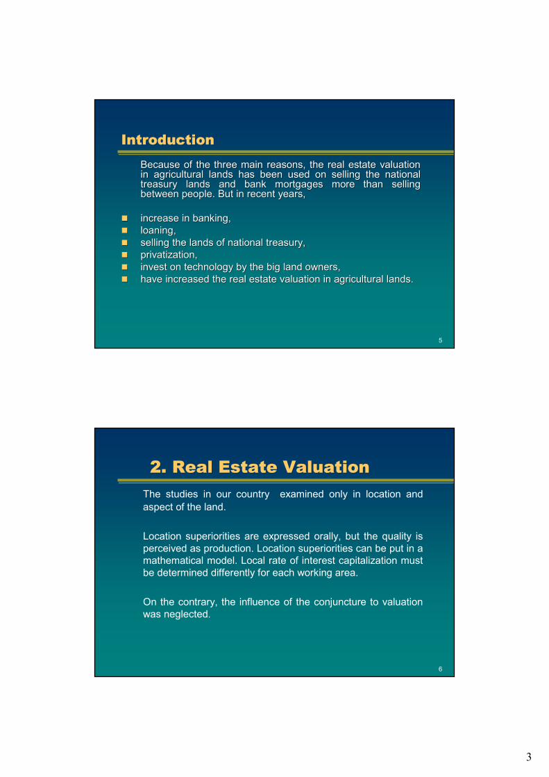
IntroductionIntroductionBecause of the three main reasons, the real estate valuation Because of the three main reasons, the real estate valuation in agricultural lands has been used on selling the national in agricultural lands has been used on selling the national treasury lands and bank mortgages more than selling treasury lands and bank mortgages more than selling between people. But in recent years,between people. But in recent years,
increase in banking,increase in banking,loaning,loaning,selling the lands of national treasury,selling the lands of national treasury,privatization,privatization,invest on technology by the big land owners, invest on technology by the big land owners, have increased the real estate valuation in agricultural lands.have increased the real estate valuation in agricultural lands.
6
2. Real Estate Valuation2. Real Estate ValuationThe studies in our country examined only in location and aspect of the land.
Location superiorities are expressed orally, but the quality is perceived as production. Location superiorities can be put in a mathematical model. Local rate of interest capitalization must be determined differently for each working area.
On the contrary, the influence of the conjuncture to valuation was neglected.

4
7
2.1. Location Grading2.1. Location GradingAccording to habits in our country, local rate of interest According to habits in our country, local rate of interest capitalization is calculated by division of the annual net incomcapitalization is calculated by division of the annual net income of e of the land to the selling price. However, the lands in same class the land to the selling price. However, the lands in same class and and in same productivity may differ in their price. The reason is thin same productivity may differ in their price. The reason is the e superiority of the location to each other. superiority of the location to each other.
The location superiorities are called the The location superiorities are called the location valuation location valuation criteriacriteria. The valuation criteria and rates can be reduced or . The valuation criteria and rates can be reduced or expanded for each agriculture area. Location valuation criteria expanded for each agriculture area. Location valuation criteria are are graded as below. Grading is given according to the interviews ofgraded as below. Grading is given according to the interviews ofthe farmers of the area and the experiences from the applicationthe farmers of the area and the experiences from the applications.s.
8
2.2. Soil Quality2.2. Soil QualityThe amount of the organic element, dampness, soil class, irrigatThe amount of the organic element, dampness, soil class, irrigation ion facility, grade etc. affects the quality of an agricultural landfacility, grade etc. affects the quality of an agricultural land. In this . In this study area, the climate is continental, according to the averagestudy area, the climate is continental, according to the average of of long years it gets rain 300 mm/year. The topography of the area long years it gets rain 300 mm/year. The topography of the area is is little hilly. Most part of the area is in 2little hilly. Most part of the area is in 2--3 % grade/slope, it has rarely 3 % grade/slope, it has rarely 44--5 % grade. Alternately agriculture has been applied and after ev5 % grade. Alternately agriculture has been applied and after every ery alternate the land has left unsown (U). alternate the land has left unsown (U).
For that reason, in calculation of the annual net income and in For that reason, in calculation of the annual net income and in land land planting planplanting plan this was taken into the consideration. The part where this was taken into the consideration. The part where the grade is 4% or more is a little stony, calcareous and has shthe grade is 4% or more is a little stony, calcareous and has shallow allow soil. The general feature of the soil is, light brownsoil. The general feature of the soil is, light brown--grey colour, poor grey colour, poor structured, clayey, loamy, has low organic ingredient. These arestructured, clayey, loamy, has low organic ingredient. These areas as are 2nd are 2nd --3rd class dry land group. Wheat (W) and barley (B) are 3rd class dry land group. Wheat (W) and barley (B) are planted on these lands. planted on these lands.

5
9
Soil QualitySoil Quality
The part where the grade is 1The part where the grade is 1--2% is watered, has medium2% is watered, has medium--high high organic ingredient. These areas are 1st organic ingredient. These areas are 1st --2nd class watered land 2nd class watered land group. Industrial plants like sugar beet (SB) and sunflower (S),group. Industrial plants like sugar beet (SB) and sunflower (S),wheat, barley and a few peach and cherry trees are planted on wheat, barley and a few peach and cherry trees are planted on these landsthese lands
10
2.3. Capitalization Interest2.3. Capitalization InterestInterest is a cost which is paid to the owner of the capital for the usage of a certain amount of capital in a certain time. Local rate of interest capitalization is the usage right of the capital on land. Farmers are bound to the land, because it is trustable, has minimum risk, can’t be carried, can’t be increased and giving the owner the favour of monopoly.
Using the Market interest rates on determination of the rate of interest capitalization is acceptable for the developed countries. This rule is not valid in our country where the national income is very low and the population rate is not below 10%.

6
11
Capitalization InterestCapitalization InterestIn order to calculate the local rate of interest capitalization,In order to calculate the local rate of interest capitalization, there there must be a similar land parcels which have the similar features must be a similar land parcels which have the similar features and recently sold like the land where the evaluation will took and recently sold like the land where the evaluation will took place. place.
Since there are very big rates between the actual prices of the Since there are very big rates between the actual prices of the lands and the prices at Property Register Management in our lands and the prices at Property Register Management in our country, country, the prices at Property Register Management are not prices at Property Register Management are not investigated. In spite of this, some of the trusty villagers whoinvestigated. In spite of this, some of the trusty villagers whohave no excuse to be an expert and the land owners are asked have no excuse to be an expert and the land owners are asked the prices after swearing.the prices after swearing.
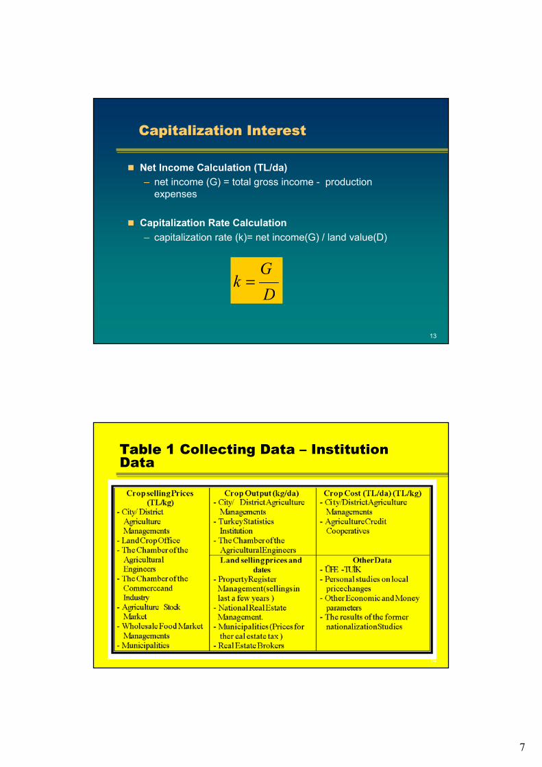
Which data will be collected from which institution is given in Which data will be collected from which institution is given in Table1.Table1.
12
Capitalization InterestCapitalization InterestCorp prices in our study area are taken from the DistrictAgriculture Management and Agriculture Stock Market. Data of the crop outputs are taken from the District Agriculture Management, land prices are taken from the real estate agencies and National Real Estate Management.
Capitalization Rate Calculation
Total Income Calculation (TL/da)– gross income (main crop) = average output (kg/da) x crop
price (TL/kg)– gross income (secondary crop) = average output (kg/da) x
crop price (TL/kg)– total gross income = gross income (main crop) + gross
income (secondary crop
7
13
Capitalization InterestCapitalization Interest
Net Income Calculation (TL/da)– net income (G) = total gross income - production
expenses
Capitalization Rate Calculation– capitalization rate (k)= net income(G) / land value(D)
DG
k =
14
Table 1 Collecting Data – Institution Data

8
15
2.4. Conjuncture2.4. ConjunctureReal estate valuation means, evaluation of a real estate according to the market habits by one of the methods suitable to the conditions of time and the region. But conjuncture influences the value of real estate as the location and the soil quality.
Conjuncture expresses the whole actions of the economy of acountry like up and down and wavy. In other way, it refers thesituation that every condition and position exist.
Conjuncture is every kind of political and economic undulationshappened in the world and in our country. It influences thecountries very little which have very low inflation and high income(national income 20000 $ and more).
16
ConjunctureConjuncture
On the contrary real estate market was influenced in our country which inflation rate is 10% and national income is 5000 $.
In this case, investment tools go away from the real estate market and stock market, and go to the foreign exchange and gold.
In our country, regression was seen in real estate market.Since there isn’t any change in the conjuncture in Turkey, no conjunctural change has been observed.

9
17
3. Application3. ApplicationFor this study, the vacant lots of the state in the For this study, the vacant lots of the state in the ��saksak village of village of Konya in Turkey of which selling was the subject to the Konya in Turkey of which selling was the subject to the evaluation by the court was chosen . evaluation by the court was chosen .
��saksak village is in the Northeast of Konya which is 210 km far village is in the Northeast of Konya which is 210 km far and has 6250 ha and has the population of 650 people. It has and has 6250 ha and has the population of 650 people. It has continental climate, watered lands and various crop types. The continental climate, watered lands and various crop types. The process for evaluation was followed as below. The Study Area process for evaluation was followed as below. The Study Area Map is seen in Figure 1. Map is seen in Figure 1.
K1, K2, K1, K2, …… comparisoncomparison parcelparcelD1, D2, ..: D1, D2, ..: evaluationevaluation parcelsparcels
18
Application
10
19
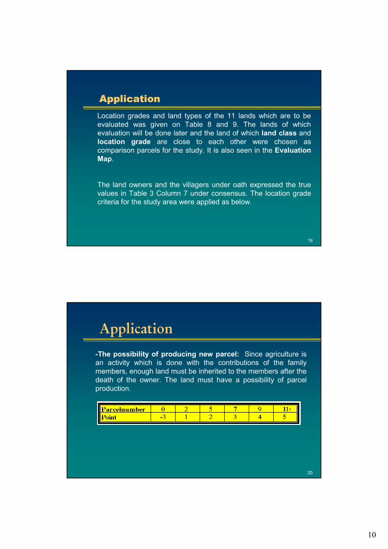
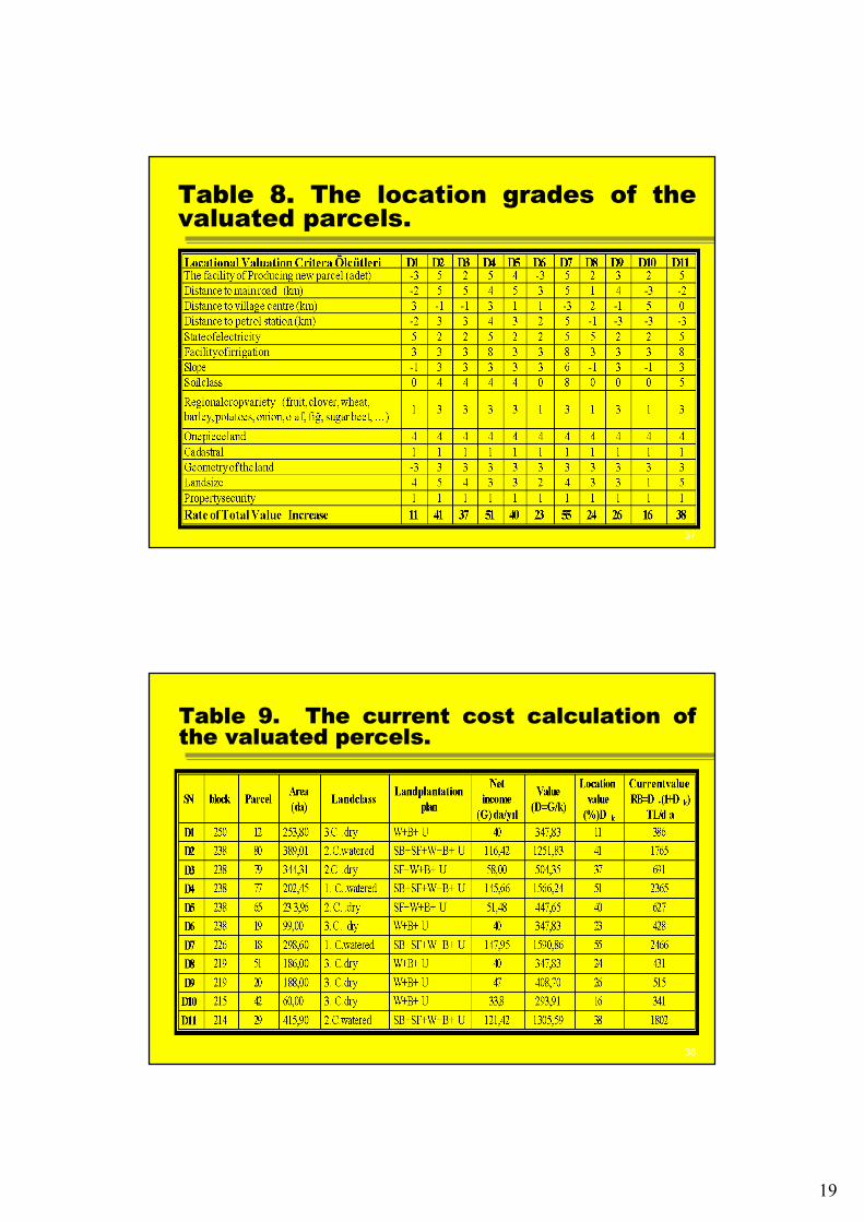
ApplicationApplicationLocation grades and land types of the 11 lands which are to be evaluated was given on Table 8 and 9. The lands of which evaluation will be done later and the land of which land class and location grade are close to each other were chosen as comparison parcels for the study. It is also seen in the Evaluation Map.
The land owners and the villagers under oath expressed the true values in Table 3 Column 7 under consensus. The location grade criteria for the study area were applied as below.
20
ApplicationApplication
-The possibility of producing new parcel: Since agriculture is an activity which is done with the contributions of the family members, enough land must be inherited to the members after the death of the owner. The land must have a possibility of parcel production.
11
21
ApplicationApplication
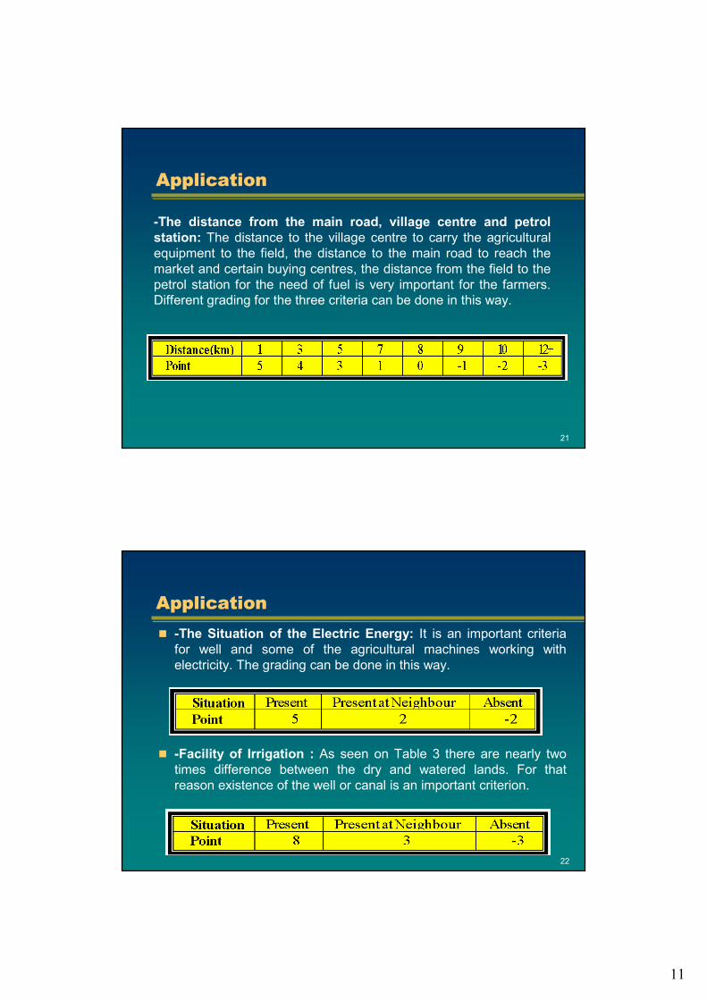
-The distance from the main road, village centre and petrol station: The distance to the village centre to carry the agricultural equipment to the field, the distance to the main road to reach the market and certain buying centres, the distance from the field to the petrol station for the need of fuel is very important for the farmers. Different grading for the three criteria can be done in this way.
22
ApplicationApplication-The Situation of the Electric Energy: It is an important criteria for well and some of the agricultural machines working with electricity. The grading can be done in this way.
-Facility of Irrigation : As seen on Table 3 there are nearly two times difference between the dry and watered lands. For that reason existence of the well or canal is an important criterion.
12
23
ApplicationApplication
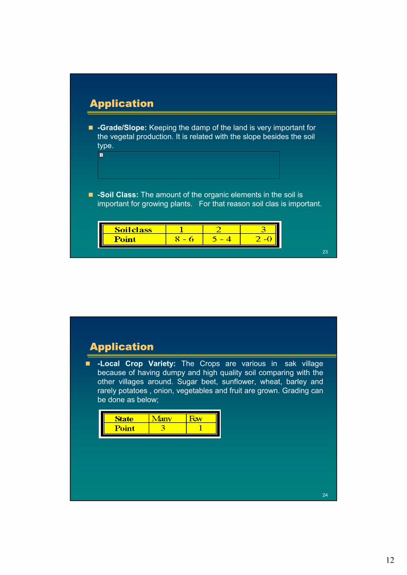
-Grade/Slope: Keeping the damp of the land is very important for the vegetal production. It is related with the slope besides the soil type.
-Soil Class: The amount of the organic elements in the soil is important for growing plants. For that reason soil clas is important.
24
ApplicationApplication-Local Crop Variety: The Crops are various in �sak village because of having dumpy and high quality soil comparing with theother villages around. Sugar beet, sunflower, wheat, barley and rarely potatoes , onion, vegetables and fruit are grown. Grading can be done as below;

13
25
ApplicationApplication
-The size and being one piece of the land: All the lands sold by the state are big enough to support a farmer family ( 100 da forKonya) and in one piece. Four points are given to one piece lands. Size grading can be done as below;
26
ApplicationApplication
-Cadastre: Cadastre studies of the area are completed, for that reason 1 point is given to all lands.
-The Geometry of the Land: All the lands in the village are in rectangular shape and the number of the corner points are 4 or 5. The angle edges of comparison parcels which were evaluated are nearly 90o with each other. For that reason the loss of land tracking are very little.
14
27
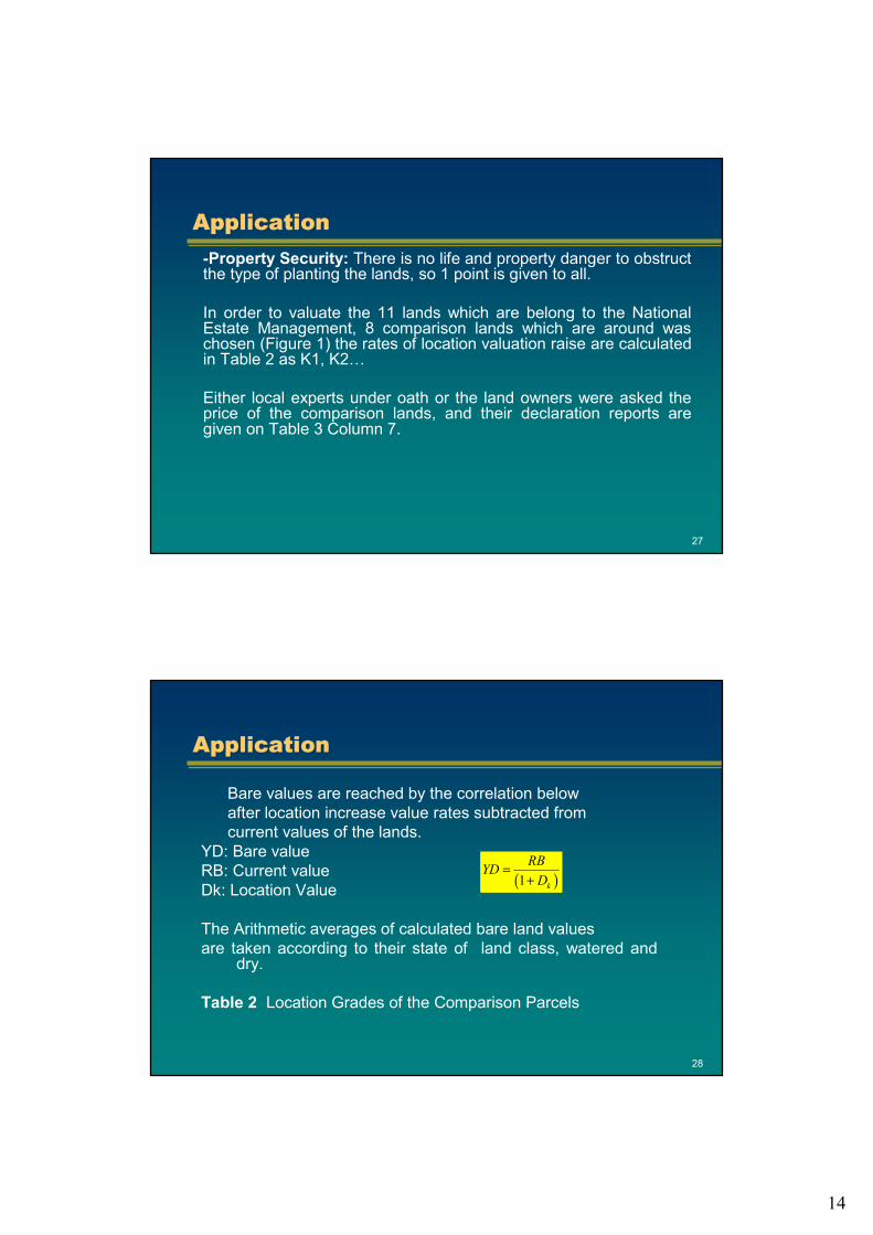
ApplicationApplication-Property Security: There is no life and property danger to obstruct the type of planting the lands, so 1 point is given to all.
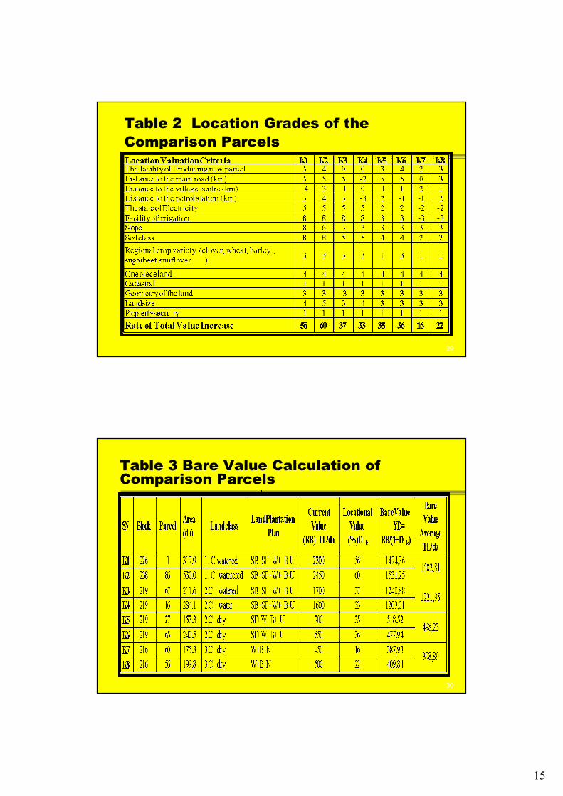
In order to valuate the 11 lands which are belong to the National Estate Management, 8 comparison lands which are around was chosen (Figure 1) the rates of location valuation raise are calculated in Table 2 as K1, K2…
Either local experts under oath or the land owners were asked the price of the comparison lands, and their declaration reports are given on Table 3 Column 7.
28
ApplicationApplication
Bare values are reached by the correlation belowafter location increase value rates subtracted fromcurrent values of the lands.
YD: Bare valueRB: Current valueDk: Location Value
The Arithmetic averages of calculated bare land valuesare taken according to their state of land class, watered and
dry.
Table 2 Location Grades of the Comparison Parcels
( )1 k
RBYDD
=+
15
29
Table 2 Location Grades of theComparison Parcels
30
Table 3 Bare Value Calculation of Comparison Parcels

16
31
ApplicationApplication
The 11 land belongs to the National Estate Management are 1st class watered, 2nd class watered, 2nd class dry and 3rd class dry lands.
The widespread land planting plans according to the land class is determined in �sak village. According to these plans, annual net income of the 1st class watered, 2nd class watered, 2nd class dry and 3rd class dry lands are calculated. These are shown in Table4, Table 5 and Table 6.
32
Table 4 Local crops and production grown in the 1st class watered land.
planting plan in 1st class watered land = SB + SF + W + B + U = 5 years

17
33
Table 5 Local crops and production grown in the 2nd class watered land.
planting plan in 2nd class watered land = SB + SF + W + B + U = 5 yearsplanting plan in 2nd class dry land = SF + W + B + U = 4 years
34
Table 6 Local crops and production grown in the 3rd class dry land.
planting plan in 3rd class dry land = W + B + U = 3 yıl
18
35
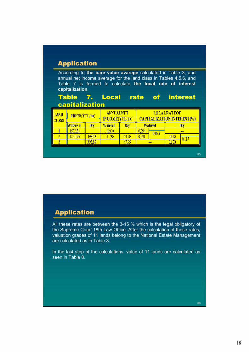
ApplicationApplicationAccording to the bare value avarege calculated in Table 3, andannual net income average for the land class in Tables 4,5,6, andTable 7 is formed to calculate the local rate of interestcapitalization.
Table 7. Local rate of interestcapitalization
36
ApplicationApplication
All these rates are between the 3-15 % which is the legal obligatory of the Supreme Court 18th Law Office. After the calculation of these rates,valuation grades of 11 lands belong to the National Estate Management are calculated as in Table 8.
In the last step of the calculations, value of 11 lands are calculated as seen in Table 8.
19
37
Table 8. The location grades of thevaluated parcels.
38
Table 9. The current cost calculation of the valuated percels.
20
39
4. Conclusions4. ConclusionsThe usage of the land which is one of the basic components ofhuman life for urban, industrial, transport and agriculture has beenincreasing day by day. The intensive demand to the agricultural areas from different sectors and nourishment, the value of the agricultural lands has been changing.
For this reason, the valuation of the agricultural lands become important. Land valuation is done fort he aims like, nationalization, buying, getting loan and mortgage.
Whatever is the aim, the valuation has been done according to theincome management as it is a legal obligatory. However,locational value raise and conjuncture are always neglected in these evaluations.
40
ConclusionsConclusionsEverybody knows that the prices are not true. Instead of these prices villagers’ statements who are under oath are taken into theconsideration. In order not to be these happen, land buying andselling charges and land taxes should be abolished or decreased inthe rate of 0,1%.
In this way the real prices of the land will be given to the PropertyRegistration Managements and the valuation map will be formed easily, the groups of buyers and sellers and public will be protectedagainst deceive by current and reliable data.
21
41
CONTACTSCONTACTS
Dr. Mehmet ERTAŞ
AddressSelcuk University, Teknik Bilimler MYO,
42075
Konya / TÜRKİYE
Tel. +09 332 223 23 76Fax +09 332 241 01 85
Email: [email protected]
42
THANKS
22
43
Thanks