
The International Land Model Benchmarking Project
23
The International Land Model Benchmarking Project Keith Szafranski/istockphoto Jim Randerson and Forrest Hoffman Earth System Science UC Irvine
Transcript of The International Land Model Benchmarking Project

The International Land Model Benchmarking Project
Keith Szafranski/istockphoto
Jim Randerson and Forrest Hoffman Earth System Science
UC Irvine


International Land Model Benchmarking (ILAMB) Project Goals:
• Develop benchmarks for land model performance, with a focus on carbon cycle, ecosystem, surface energy, and hydrological processes. The benchmarks should be designed and accepted by the community.
• Apply these benchmarks to global models
• Support the design and development of a new, open-source, benchmarking software system for either diagnostic or model intercomparison purposes
• Strengthen linkages between experimental, monitoring, remote sensing, and climate modeling communities in the design of new model tests and new measurement programs

Key operational elements of ILAMB 1.0 benchmark
• Traceable lineage for data sets – Lineage, units, transformations documented in readme
files – Datasets must be publicly available so that they can be
distributed with ILAMB 1.0 system • Clear documentation of model regridding and variable
transformation • A document describing the metrics used to score each
dataset – For example, Taylor score, spatial correlation coefficient
• Community agreement on scoring metrics and weighting across datasets

Status Update • Almost all CMIP5 output is available (some bugs still being fixed) • Progress on model evaluation:
– soil carbon (Todd Brown, Allison, Post, et al.) – soil temperatures (Koven and Riley) – hydrology (Dave Lawrence) – atmospheric CO2 (Keppel Aleks, Hoffman, Stephens, et al.) – Ecosystem carbon fluxes (Randerson, Mu, et al.) – Turnover times and carbon stocks (Xia, Luo, Wang)
• Conceptual framework defined – Yiqi Luo synthesis paper submitted to BGD
• Next critical step is integration and standardization – At AGU we decided that UCI would be a central clearing house for
collating obs. datasets and will take a first step at standardization of the different disciplines
– We are in the process of detailing a metrics document that discusses how scoring system is designed, cost functions, data-model comparison approach

Example Analysis – Examination of Seasonal Dynamics of Ecosystem Carbon and Energy Fluxes
• Atmospheric CO2 is drawn down too early in most CMIP5 models

What is causing the phase bias in atm. CO2? Ameriflux observations provide some insight
• GPP appears to be the primary culprit for the early NEE uptake and CO2 drawdown
Models sampled at all sites north of 40N

Early onset of photosynthesis has consequences for the seasonal dynamics of surface energy exchange
• Early use of snow melt may cause drought stress in late summer

Does the early onset of photosynthesis have a climate signature?

Solutions – Can we fix this and change precipitation dynamics?
• Biochemistry – Is the Q10 on Vcmax to small? – Does Btran limit GPP in the spring the way we expect it to
when soils are frozen? • Physiology
– Do we need to build in a frost avoidance strategy into the model?
– Unpackaging membrane and protein systems increases vulnerability to late spring frost events
• Phenology – Compare APAR and LAI from satellite obs. with the model

ILAMB 1.0 benchmark is now under development

ILAMB 1.0 benchmark is now under development

Table Information for variables of Benchmark and CMIP5

Annual mean of Global Burnt Area
In 1997-2005
Unit: %/yr
NorESM1-M vs GFED3.1
Global mean: 378 Mhayr
Global mean: 2768 Mha/yr

Peak fire season
NorESM1-M vs GFED3.1
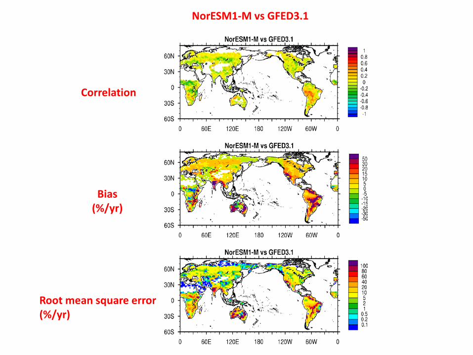
Correlation
Bias (%/yr)
Root mean square error (%/yr)
NorESM1-M vs GFED3.1

Burned Area Fraction Peak Fire Month (PFM)

Burned Area Fraction Seasonal Cycle Score (OPS)

Dataset Name: original GFED3 (MCD64A1) Burned Area Variable Names: BurntArea, LandCoverDist Reference of Original Data: Giglio, L., J.T. Randerson, G.R. van der Werf, P.S. Kasibhatla, G.J. Collatz,D.C. Morton, and R.S. DeFries. Assessing variability and long-term trends in burned area by merging multiple satellite fire products. Biogeosciences. 6: 1171~S1186, 2010. Downloaded Date and Person: By M. Mu (ESS, University of California Irvine) on Apr. 20, 2010 Name and Version of Original source: MCD64A1, GFED3.1 Temporal Resolution: monthly from 1997 till 2005 Spatial Resolution: 0.5x0.5 degree Unit: hectares per grid cell Data Format: hdf
Dataset Name: derived GFED3 Burned Area Variable Name: burntArea General Info: This product was derived from GFED3 (MCD64A1) dataset. Approach: Derived Data Code: ~/CODES/conversion-ba-gfed3.ncl Temporal Resolution: monthly from 1997 till 2005 Spatial Resolution: 0.5x0.5 degree Unit: unitless Data Format: netCDF 3 Data File Structure: burntArea_YearMonth.nc
Readme for original GFED3 Burned Area Readme for derived GFED3 Burned Area

Readme for original CERES radiations Readme for derived CERES albedo
Dataset Name: original CERES radiation Variable Names: Total_sky_Sfc_Net_SW_Flux_Mod_B__1, Total_sky_Sfc_Down_SW_Flux_Mod_B__1 Reference of Original Data: Young, D. F., P. Minnis, D. R. Doelling, G. G. Gibson, T. Wong, Temporal Interpolation Methods for the Clouds and the Earth Radiant Energy System (CERES) Experiment. Journal of Applied Meteorology, Vol 37(6), 572-590, 1998. Downloaded Date and Person: By M. Mu (ESS, University of California Irvine) on Oct. 22, 2011 Name and Version of Original source: CERES (The Clouds and the Earth Radiant Energy System), SRBAVG1 Terra Temporal Resolution: monthly from 2000 till 2005 Spatial Resolution: 1.0x1.0 degree Unit: watt/m^2 Data Format: hdf
Dataset Name: derived CERES albedo Variable Name: albedo General Info: This product was derived from CERES SRBAVG1 Terra radiation dataset. Approach: Net downward surface shortwave divided by total sky downward surface shortwave from CERES SRBAVG1 Terra product. Derived Data Code: ~/CODES/conversion-albedo-ceres.ncl Temporal Resolution: monthly from 2000 till 2005 Spatial Resolution: 0.5x0.5 degree Unit: unitless Data Format: netCDF 3 Data File Structure: albedo_YearMonth.nc ~

Dataset Name: original MODIS albedo Varialbe Name: Albedo_WSA_shortwave Reference of Original Data: Schaaf, C. B., W. Lucht, T. Tsang, F. Gao, N. Strugnell, L. Chen, Y. Liu, and A.H. Strahler , Prototyping the MODerate Resolution Imaging Spectroradiometer (MODIS) BRDF and Albedo Product, Proc. Int. Geosci. Remote Sens. Symp. (IGARSS'99), Hamburg, Germany, 28 June - 2 July, 1506-1508, 1999. Downloaded Date and Person: By M. Mu (ESS, University of California Irvine) on Oct. 22, 2011 Name and Version of Original source: MODIS MCD43C3 16-day 0.05 degree CMG L3, version 5 Temporal Resolution: monthly from 2000 till 2005 Spatial Resolution: 0.05x0.05 degree Unit: unitless Data Format: hdf
Dataset Name: derived MODIS albedo Variable Name: albedo General Info: This product was derived from MODIS MCD43C3 16-day 0.05 degree CMG dataset. Approach: see conversion code for detail Derived Data Code: ~/CODES/conversion-albedo-modis.ncl Temporal Resolution: monthly from 2000 till 2005 Spatial Resolution: 0.5x0.5 degree Unit: unitless Data Format: netCDF 3 Data File Structure: albedo_YearMonth.nc
Readme for original MODIS albedo Readme for derived MODIS albedo

Total annual CO2 Sampled at NOAA sites 2001-2005 mean
Year HadGEM2-ES (Tg/yr)
2001 -1170 2002 -3367 2003 -776 2004 -2780 2005 -1181 mean -1855

Questions for ILAMB 1.0 benchmark development
• For models with ensembles, should we take the mean response? • For comparing with observations at finer spatial resolution, do we:
• 1) regrid the models to the observations (this will penalize models with coarser spatial resolution)
• 2) regrid the observations to the model resolution (this will not penalize models with a coarser resolution)
• How do we reach a consensus regarding metrics and cost functions over the next two months for a given variable?
• For atmospheric CO2 comparisons, we will run the CMIP5 set of NBP from 1990-2005 through GEOS-Chem with MERRA reanalysis and use observed fossil fuel and data assimilation ocean fluxes. Are there other atmospheric models that would like to participate?
• Should we reorganize the approach for publishing the different components?
• Can individuals help procure their favorite datasets for ILAMB?


