THE INTERIOR GEOLOGICAL SURVEY MAGNETIC...
56
UNITED STATES DEPARTMENT OF THE INTERIOR GEOLOGICAL SURVEY MAGNETIC STUDIES OF SELECTED GEOLOGIC AND AEROMAGNETIC FEATURES I N SOUTHWEST SEWARD PENINSULA, WEST-CENTRAL ALASKA by John W. Cady and C. L. Hunnnel Open-File Report 76-425 1976 This report is preliminary and has not been edited or reviewed for confo.mity with Geological.Survey standards.
Transcript of THE INTERIOR GEOLOGICAL SURVEY MAGNETIC...

UNITED STATES DEPARTMENT OF THE INTERIOR
GEOLOGICAL SURVEY
MAGNETIC STUDIES OF SELECTED GEOLOGIC AND AEROMAGNETIC FEATURES
IN SOUTHWEST SEWARD PENINSULA, WEST-CENTRAL ALASKA
by
J o h n W. Cady and C. L . Hunnnel
O p e n - F i l e R e p o r t 76-425
1976
T h i s r e p o r t is p r e l i m i n a r y a n d has not b e e n e d i t e d or reviewed for confo.mity with G e o l o g i c a l . S u r v e y s t a n d a r d s .

CONTENTS
INTRODUCTION
Acknowledgments
GENERAL GEOLOGY
Bedrock geology
Higher grade rocks
Igneous and metaigneous rocks
S t r u c t u r a l geology
Older s t r u c t u r e s
Younger s t r u c t u r e s
MAGNETIC STUDIES
Previous geophysical work
Geophysical work methods
RESULTS OF AEROMAGNETIC STUDIES
Regional desc r ip t ion of aeromagne t i c data
Magnetic modeling and i ts i n t e r p r e t a t i o n
Models f o r highs A and B
Models f o r lows labeled C
RESULTS OF GROUND MAGNETIC STUDIES
Magnetic p r o p e r t i e s of rocks
Mgp of in fe r red magnetic litholog-les
SUMMARY AND CONCLUSIONS
REFERENCES

ILLUSTRATIONS
P l a t e 1 - Map showing selected geologic and aeromagnetic f ea tu re s in
southwest Seward Peninsula, west-central Alaska, s ca l e 1:125,Q00.
Figure 1 - Index map
Figure 2 - Map of Seward Peninsula, Alaska showing areas covered by
aeromagnetic surveys i n 1968 and 1971 (Figure 2 on P la te 1).
Figure 3 - Two-dimensional magnetic model f o r the Penney River high
(high A). JT i n t h i s and f igures 4 and 5 is t h e inferred t o t a l
magnetization (remanent plua induced) assumed pa ra l l e l t o t he
ear th ' s magnetic f i e l d .
Figure 4 - Two-dimensional magnetfc models f o r the Ugh south of the
Kigluaik Mountains (high B) . JT is inferred t o t a l magnetization.
Figure 5 - Two-dimensional magnetic model along profi ' le C1C2 f o r the
low over a carbonate body. JT is inferred t o t a l magnetization.
Magnetization of s c h i s t is 42 x gauss around body 1 and
63 x around body 2.
Figure 6 - Ground magnetometer p r o f i l e s along t raverse l i n e s shown i n
de t a i l ed study a rea of f i gu re 2. Beneath p ro f f l e s a r e graphs
showing numbered sample locat ions , measured remanent magnetization
( c i r c l e s ) , and induced magnetization computed from measured
suscep t ib i l i t y ( t r iangles) . See Appendix f o r expanded views of
p rof i les .

Figure 7 - Histogram showlng measured remanent magnetization and
s u s c e p t i b i l i t y . Hatchured a r e a s i n d i c a t e specimens w i t h t h e
Konigsberger r a t i o Q ( r a t i o of remanent t o induced magnetization)
g r e a t e r than o r equal t o 1. N is t h e t o t a l number of samples,
n t h e number of samples wi th in t h e indicated range of
s u s c e p t i b i l i t y o r remanent magnetization, k the s u s c e p t i b i l i t y ,
and J t h e remanent magnetization.
The Appendix con ta ins t h e p r o f i l e s a a t through zz" shown i n f i g u r e 6,
a s w e l l as p r o f i l e s Caat) through Qj") from ou t s ide t h e d e t a i l e d
s tudy area . The hor izon ta l scale is approximately 1 inch
1 m i l e . The symbol o i n d i c a t e s measured remanent magnetfzation J;
a i n d i c a t e s induced magnetization computed from measured
s u s c e p t g b i l i t y and the e a r t h ' s magnetic f i e l d .
iii

INTRODUCTION
Aeromagnetic anomalies i n t he western Seward Peninsula show
simple pa t te rns of g r ea t l a t e r a l extent . Our purpose was t o iden t i fy
t he sources of t h e anomalies i n t h e f i e l d while de ta i l ed geologic
mapping was ongoing, so that the aeromagnetic map could be used t o
extrapolate the geologic mapping i n t o a wider area . Following a b r ie f
geological introduction, w e focus on the i n t e rp re t a t i on of aeromagnetic
maps i n t he southwest Seward Peninsula and t h e presenta t ion of ground ,
magnetometer p r o f i l e s and magnetic s u s c e p t i b i l i t y and i n t ens i t y
measurements of samples col lected along t h e ground magnetometer
p rof i l es .
Acknowledgments
Fred Walton of t he former Marine Geophysics Section of t he
National Oceanic and Atmospheric Agency made preliminary ground
magnetic t raverses f o r these inves t iga t ions near Nome i n 1970. A t an
ea r ly s tage of the invest igat ion, Andrew Griscom reviewed the
aeromagnetic survey and discussed with Hunnuel the plan t o co r r e l a t e
geologic and aeromagnetic f ea tu r e s of the area . W. F. Hanna provided
a s u s c e p t i b i l i t y bridge f o r measuring rock s u s c e p t i b i l i t i e s , and took
a personal i n t e r e s t i n seeing that t h e measurements were properly made.
Personnel of the U.S. Geological Survey rock magnetics laboratory
kindly permitted t h e use of their f a c i l i t i e s f o r sample coring and
remanent magnetization measurements.

GENERAL GEOLOGY
Southwest Seward Peninsula includes elements of nearly a l l of the
major geological fea tures of the Peninsula, and many of these a r e
be t t e r represented and exposed the re than elsewhere on it. Among
these a r e regional ly metamorphosed rocks which make up most of the
bedrock, two main groups of s t ruc tures , two s u i t e s of metal l i ferous
lodes associated with them, and widespread s u r f i c i a l deposits and
cover. Among the l a t t e r a r e beach, g lac ia l , and a l l u v i a l deposits
which have yielded placer gold derived from the lodes which has
accounted f o r three-fourths of t h e mineral production from t h e e n t i r e
peninsula.
Bedrock Geology
The bedrock of t h e southwest Seward Peninsula can he read i ly
divided i n t o te r ranes composed mainly of higher and lower grade
metamorphic rocks; of these, t he former a r e associated with t h e
youngest s t ruc tu re s of the region, whereas the l a t t e r contain the only
major older s t ruc tures .
Higher grade rocks
Higher, generally amphibolite grade metamorphic rocks, a r e
localized almost e n t i r e l y i n t h e Kigluaik and Bendeleben Mountain
ranges; because the higher grade metamorphites and the igneous rocks
in them a r e bes t exposed i n t h e Kigluaik Mountains, but a r e undivided

f o r t he most par t , both have been included in the Kigluaik Complex
shown on P la te 1.
The Kigluaik Complex cons i s t s predominantly of metasediments
with subordinate orthogneiss bodies, and includes numerous s i l i c i c and
mafic dikes and sills. The metasediments comprise gradat ional ly
inter layered ca l c - s i l i c a t e rocks and marble, quartz and quartz-feldspar
b i o t i t e s c h i s t and quar tz i te , a l l more o r l e s s graphi t ic . The contact
between the metasedimentary rocks of the higher and lower grade
terranes occurs e i t h e r a s a f a u l t o r is covered by s u r f i c i a l materials
(P la te 1). Despite this, a t h i c k sequence of t h e lower grade
metasediments, which i s in te rpre ted t o cons t i t u t e t h e i r basal portion,
can be correla ted with the former on the bas i s of gross l i thology a s
in fe r red from mineralogy and physical character. In addit ion, segments
of metasediments occur on both s ide s of t h e f a u l t which a r e s imi la r t o
t he o thers i n bulk composition but a r e of intermediate metamorphic
grade. Together, these ind ica te t h a t t he re la t ionship between the
higher grade and basal por t ion of the lower grade metasediments is a
regular, gradational s t r a t i g r aph ic and t r ans i t i ona l metamorphic one.
Numerous, generally concordant orrhogneiss bodies of a l l s i z e s
a r e present throughout t h e metasediments of t h e Kigluaik Complex;
only t h e l a rges t of these a r e shown on P l a t e 1. Whole rock, ~ b / ~ r ,
i sotopic ages of 750 m.y. were obtained from two of these bodies near
M t . Osborn (Sainsbury, 1972, p. 2). This ind ica tes that the age of
the higher grade metasediments i s Precambrian Y and, a s such, they
a r e t he o ldes t rocks known on Seward Peninsula.

Lower g rade rocks
Nearly a l l of t h e bedrock of southwest Seward P e n h s u l a ou t s ide
t h e Kigluaik and Bendeleban Mountafns is composed of metamorphic
rocks of greenschis t grade, t h e only exceptfons being sporadic igneous
bodies and a few occurrences of still lower grade rocks. T.he g r e a t e s t
proport ion of t h e lower grade rocks c o n s i s t s of metaaedimentary and
layered metavolcanogenic roclcs of submarine o r i g i n . These, i n turn,
a r e composed of t h i c k and a r e a l l y extens ive exposures of only a few
kinds and s u i t e s of rocks; however, t h e r e l a t i o n s h i p s of these rocks
a r e s t i l l only imperfect ly known. For the purpose of t h i s r epor t ,
only the fewest of these u n i t s needed t o d e l i n e a t e the. g ross charac te r
of t h e bedrock a r e shown; f u r t h e r , through t h e s e l e c t i v e use of symbols
f o r these u n i t s , only those occurrences which have been checked and
are i n accord w i t h t h e r e s u l t s of the cur ren t f i e l d inves t iga t ions
a r e indicated (P la te 1). The u n i t s inc lude t h e basa l g r a p h i t i c schist
and marble u n i t sequence c i t e d above, t h e most extens ive exposures of
two marble u n i t s , and two t h i c k sequences of in te r l ayered c h l o r i t i c
s c h i s t and marble.
.Rocks i n t e r p r e t e d t o form t h e basa l por t ion of t h e lower grade
t e r r a n e c o n s i s t of in t imate ly , g rada t iona l ly in te r l ayered g r a p h i t i c
quartzose, calcareous, and f e l d s p a t h i c chlor i te-muscovi te s c h i s t ,
q u a r t z i t e , and marble. A s described ahove, t h e y s t rong ly resemble t h e
high-grade metasediments i n g ross composition and physica l character ,
and s o a r e i n f e r r e d t o be r e l a t e d t o t h e m s t ra t i 'graphfcal ly . The
basa l g r a p h i t i c sequence is exposed i n four prominent b e l t s ; one
4

extending sou th from Te l le r , two n o r t h from Nome and Solomon, and a
narrower, eastward-trending b e l t jo in ing t h e l a t t e r south of the
Kigluaik Mountains ( P l a t e 1). Along with t h e i r presumed higher grade
counterpar ts , rocks belonging t o this sequence a r e thought t o be of
Precambrian Y age.
Marble of two d i s t i n c t types--gray and blue-gray, sch i s tose t o
slabby and massive marble and buff-weathering s c h i s t o s e marble--is
ubiquitous throughout a l l u n i t s and a l l p a r t s of t h e lower grade
t e r rane . Only t h e l a r g e s t exposures of b o t h types are shown on P l a t e
1. The most extens ive exposures of blue-gray marble crop out i n a
near ly continuous, inverted U-shaped b e l t between the Snake and
Solomon Rivers and south of Salmon Lake (P la te 1). Smaller and more
i s o l a t e d exposures of marble of s i m i l a r charac te r l i e east and west
of t h i s b e l t ; f o r t h e most p a r t , t h e s e exposures a r e shown a s
depicted and designated f o r age by Sainsbury and o t h e r s (-1972, 1972a),
e s p e c i a l l y t h e l a r g e s t of t h e s e i n the western p a r t of t h e region
( P l a t e 1 ) .
The t h i c k e s t and most extens ive exposure of buf f-weathering
sch i s tose marble l i e s i n t h e south-central p a r t of t h e region.
However, a f a r more widespread exposure of similar marble continues
eastward t o the Darby Mountains from the small area shown near Council
(Mil ler and o t h e r s , 1972). Like the contact r e l a t i o n s of most of t h e
u n i t s i n t h e lower grade t e r rane , t h o s e of the marble have no t been
determined f o r c e r t a i n . Despi te t h i s , Sainsbury cor re la ted a l l of
t h e buff-weathering s c h i s t o s e marble wi th an a r g i l l a c e o u s limestone
5
which occurs widely throughout northwestern Seward Peninsula (Sainsbury,
1972). The only exposure of t h i s limestone i n t h e a r e a crops out near
T e l l e r ( P l a t e 1). Sainsbury assigned a la te Precambrian age t o t h i s
l imestone and its metamorphosed equivalents (Sainsbury, 1972, p. 3 ) .
The most widespread and probably t h e t h i c k e s t sequencqs of lower
grade metamorphites i n southwest Seward Peninsula are composed mainly
of f e ldspa th ic greenschis t and abundant, predominantly g rada t iona l ly
in te r l ayered ca lcareous and quartzose v a r i a n t s of it; both brown
s c h i s t o s e and blue-gray marble, and g r a p h i t i c q u a r t z i t e and s c h i s t a r e
present throughout t h e sequences, genera l ly , a s sporadic and subordinate
beds and members. The most extens ive exposure of t h e greenschis t and
marble crops ou t throughout t h e south-central p a r t of the area. A
s i m i l a r sequence of rocks which occurs i n t h e e a s t e r n p a r t of t h e
region w a s f i r s t mapped by Smith i n t h e Solomon a r e a and named t h e
Casadepaga S c h i s t (1910, p. 70) ; although not so named, t h e same rocks
were extended and f u r t h e r mapped e a s t of t h i s a rea by Smith and Eakins
t h e following year (1911, p. 40-41). Following Sainsbury, who re ta ined
smith 's des ignat ion, most of both s u i t e s of rocks a r e thought t o be
of submarine volcanic and volcanogenic o r i g i n and of Precambrian age
(Sainsbury, 1972, p. 2).
Igneous and metaigneous rocks
Igneous and metaigneous rocks occur i n both t h e higher and lower
grade t e r r a n e s of southwest Seward Peninsula. The or thogneiss bodies
i n t h e Kigluaik Complex which have yie lded wholerock i so top ic ages of
6
750 m.y. a r e described above. I n add i t ion , small t o moderate-sized
b a s a l t i c and g r a n i t i c d ikes and sills. a r e present throughout t h e
Kigluaik Mountains. For t h e l imi ted purpose of t h i s r epor t , only t h e
s ing le , l a r g e s t g r a n i t i c body a t the western end of t h e complex is
shown on P l a t e 1. Sainsbury and o t h e r s assigned a Cretaceous age t o
t h i s body (1972, p. 11). The b a s a l t i c roclcs a r e most probably of
Ter t i a ry age.
I n marked c o n t r a s t wi th the Kigluaik Complex *re examples of
n e i t h e r has been found, gabbroic and metamafic bodies are abundant
throughout much of t h e lower grade t e r rane . Again, because of t h e
l imi ted purpose of t h i s r epor t , only t h e gabbro bodies near Te l l e r a s
shown by Sainsbury (19721, and t h e l a r g e s t matamafic body i n t h e
c e n t r a l p a r t of t h e a r e a a s mapped by Hummel (1962b) a r e shown on
P l a t e 1; smaller metamafic bodies, mainly sills, of s i m i l a r l i t h o l o g i c
character , a r e e s p e c i a l l y abundant i n the greenschis t and marble un i t .
Following Sainsbury and o t h e r s (1972, p. l o ) , no age o r ages have been
assigned t o any of t h e maf i c rocks.
Numerous small and a few l a r g e metagrani t ic bodies, n e a r l y a l l
wi th m e t a t a c t i t e zones, occur i n a b e l t between Cape Nome and Salmon
Lake (Hummel, 1962a, 1962b); on ly t h e body a t Cape Nome is shown on
P l a t e 1. The lower grade metagrani t ic rocks are cor re la ted p rov i s iona l ly
wi th t h e or thogneiss bodies i n the Kigluaik Complex, but no i so top ic
ages have been obtained from them ye t .
Only a very few s i l i c i c and b a s a l t i c bodfes have been found i n
t h e lower grade ter rane . Like t h e i r l i t h o l o g i c equivalents i n t h e
7
Kigluaik Complex, they a r e thought t o be of T e r t i a r y age, but no d i r e c t
evidence f o r t h i s assignment has been. determined.
S t r u c t u r a l Geology
Major s t r u c t u r e s belonging t o two systems are represented i n
southwest Seward Peninsula, and the e f f e c t s of one of these on t h e
o the r a r e such t h a t they can be s a f e l y character ized as younger and
older . The o lde r s t r u c t u r e s are a l s o c u t by a coordinate set of
t r anscur ren t f a u l t s and f r a c t u r e s , but t h e r e l a t i o n s h i p of these t o
t h e o t h e r younger s t r u c t u r e s has not been es tabl ished.
Older s t r u c t u r e s - A l l of t h e major, o l d e r s t r u c t u r e s which have been iden t i f f+
i n southwest Seward Peninsula l i e i n t h e lower grade t e r rane . Although
of r eg iona l s i z e , they are, i n f a c t , on ly remnants of once much l a r g e r
and more extens ive s t r u c t u r a l f e a t u r e s which w e r e p a r t i a l l y destroyed
over the K i g l w i k and Bendeleben Mountain rangea and s t rong ly deformed
around them (Hummel, 1960, p. B30). The o l d e r s t r u c t u r e s inc lude
northward-trending fo lds , folded t h r u s t f a u l t s and sheets, and r e l a t e d
pe t ro tec ton ic f e a t u r e s of a l l s i z e s produced by concurrent t ec ton ic
a c t i v i t y and reg iona l metamorphism. Except where s t rong ly deformed,
t h e o l d e r s t r u c t u r e s are manifested by northward-trending b e l t s of
lower grade rocks and g ross t ec ton ic and metamorphic f e a t u r e s (P la te 1).
Cor re la t ion of a t h i c k sequence of metasedimentary rocks i n t h e lower
grade t e r r a n e wi th o t h e r s thought t o be their higher grade
8

counterpar ts i n the KigluaikMountains was described above. This, i n
conjunction wi th s t r u c t u r a l evidence, provided t h e b a s i s f o r
regarding these metasediments a s t h e basal por t ion of t h e lower grade
t e r rane . D i s t r i b u t i o n of t h e basa l rocks a s mapped throughout t h e
lower grade t e r rane , has made i t poss ib le t o d e l i n e a t e four f o l d s
which dominate and determine t h e s t r u c t u r a l conf igura t ion of t h e
lower g rade bedrock of southwest Seward Peninsula. Because the
contact r e l a t i o n s h i p s between the basa l and o the r rock u n i t s of lower
grade t e r rane , and among t h e s e l a t t e r , have no t been determined, t h e
r e s u l t i n g f o l d s have been character ized as ant i forms and synfoms.
A s manifested mainly by northward-trendbg b e l t s of basa l rocks, the
axes of antiforms l i e along t h e Snake and Solomon Rivers, extending
respec t ive ly n o r t h from Nome and Solomon i n t h e c e n t r a l p a r t of the
region, and south of T e l l e r i n t h e northwest p a r t ( P l a t e 1). The
a x i s of t h e synform between t h e ant i forms a t Nome and Solomon lies
along t h e Bonanza River. A l l of t h e s e f e a t u r e s have been given names
t o r e f l e c t t h e i r geographic loca t ion , hence t h e T e l l e r , Snake River,
and Solomon River ant i forms and t h e Bonanza River synform.
The only i n t r i n s i c evidence bearing on the time of formation of
t h e o lde r s t r u c t u r e s and r e l a t e d metamorphic f e a t u r e s c o n s i s t s of a
s i n g l e i s o t o p i c age of ca. 100 m.y. a s determined from K / A ~ da ta on
b i o t i t e (Sainsbury, 1972, p. 7). TWs coincides w i t h t h e period of
t e c t o n i c a c t i v i t y comprising east-west compression and eastward
t h r u s t i n g proposed by Pa t ton and T a i l l e u r (.1972), which provides a
regional geologic framework that could account f o r t h e trend and
charac te r of t h e o lde r s t r u c t u r e s .
9

Younger s t r u c t u r e s
The l a r g e s t and most obvious younger s t r u c t u r e i n southwest
Seward Peninsula is t h e Kigluaik U p l i f t CHuuunel, 1960, p. B33) which
c o n s i s t s of a hors t - l ike c o r e of higher grade rocks bounded by normal
f a u l t s ( P l a t e 1 ) ; P le i s tocene g l a c i a l d e p o s i t s c u t by t h e f a u l t along
t h e n o r t h s i d e demonstrate t h a t t h e u p l i f t is a still a c t i v e t ec ton ic
fea tu re . However, in t h e context of the region a s a whole, t h e
Kigluaik U p l i f t can be seen t o be but one s t r u c t u r a l element, a l b e i t
a major one, on t h e eastward-trending welt which encompasses bo th t h e
Kigluaik and Bendeleben Mountain ranges and the bedrock f o r a
considerable d i s t a n c e n o r t h of them (Sainsbury, 1972). Within t h i s
r eg iona l context , o t h e r younger s t r u c t u r e s can a l s o be discerned,
a s can t h e i r e f f e c t s on the o lder s t ruc tu res . From this, t h e Kigluaik
Arch can be recognized a s a subs id ia ry s t r u c t u r e wi th in t h e u p l i f t
( P l a t e 1); s i m i l a r l y , the eastward-trending b e l t of lower grade rocks
along t h e south s i d e of t h e u p l i f t can be recognized a s s t rong ly
deformed por t ions of o lde r , major northward-trending f o l d s . It appears
probable from t h e i r s i z e t h a t these, i n turn , once extended e n t i r e l y
ac ross c e n t r a l Seward Peninsula; i f so, only t h e i r median por t ions
were u p l i f t e d and destroyed over t h e Kigluaik-Bendeleben w e l t and
deformed remnants of t h e f o l d s can be expected nor th of t h e mountains
which correspond t o those south of t h e m . A s suggested by Grantz
(o ra l commun., 19741, t h e s e e f f e c t s s t rong ly i n d i c a t e deep-seated,
perhaps diapire-driven, t ec ton ic deformation. Such a c t i v i t y may have
begun long ago, perhaps a s e a r l y as l a t e Cretaceous o r T e r t i a r y t i m e s .
10
In addi t ion t o t h e Kig lua ikUpl i f t boundary f a u l t s , the older
s t ruc tu re s a r e a l s o cut and deformed by a s e r i e s of major, v e r t i c a l
northeast-str iking f a u l t s and a subordinate but coordinate set of
northwest-striking f a u l t s and f r ac tu re s (Plate 1). The l a rges t and
most important of these is t h e Anvil-Hunker f a u l t described e a r l i e r
by Hummel (1960, p. B35) and the Cal i fornia Creek f a u l t system named
here. Provisionally, t he se f a u l t s a r e thought t o be re la ted t o
Kaltag Fault and so t o be of t he same age, t h a t is, e a r l y t o middle
Ter t ia ry (Patton and b a r e , 1968, p. D153).

MAGNETIC STUDIES
Previous geophysical work
Two aeromagnetic maps cover the land a r e a s b w n i n Figure 1. The
nor thern ha l f w a s flown wi th a f l i g h t l i n e spacing of 1.2 ki lometres
and a f l i g h t a l t i t u d e of 300 metres above. average t e r r a i n ( S t a t e of
Alaska Department of Natural Resources, 1971). The southern ha l f was
flown w i t h a f l i g h t l i n e spacing of 1.6 ki lometres and a f l i g h t
a l t i t u d e of 820 metres above sea lwel, which here g ives a t e r r a i n
c learance of 300 t o 600 m e t r e s CU. S. Geological Survey, 1969). A l l
f l i g h t l i n e s run east-west. In add i t ion , a d e t a i l e d he l i cop te r
magnetic survey wi th a north-south f l i g h t l i n e spacing of 400 metres
and a n a l t i t u d e of 60 metres was flown over t h e beach and adjacent
water west of Nome (U. S. Geological Survey, 1969). These aeromagnetic
data , f o r which no i n t e r p r e t a t i o n s have been published, a r e presented
i n d e t a i l i n P l a t e 1. A g r a v i t y map of t h e Seward Peninsula by Barnes
(1971) was h e l p f u l i n i n t e r p r e t i n g t h e magnetic data.
A ship-borne magnetic survey was made o f f s h o r e of Nome by the
National Oceanographic and Atmospheric Administration, but t h e data
have no t been published.
Geophysbal work methods
Aeromagnetic anomalies shown in F igure 1 and P l a t e 1 w e r e
c o r r e l a t e d w i t h major geologic fea tu res . Ground geophy8ical s t u d i e s ,
conducted pr imar i ly wi th in t h e small rec tangular "deta i led s tudy area"
12

out l ined i n Figure 1 and P l a t e 1, were used i n combination with the
aeromagnetic map t o const ruct a map of inferred magnetic-lithologic
u n i t s (P la te 1) within the a rea of de ta i l ed study. Two-dimensional
model s t ud i e s of major magnetic highs show the in fe r red subsurface
geometry of t h e top of magnetic rock u n f t s (f ig. 3, 4, and 5).
F ie ld s t ud i e s included magnetometer p ro f i l i ng and rock sampling
which w e r e intended t o accura te ly l o c a t e the bollndarfes of magnetic
. rock un i t s , t o es t imate . the r e l a t i v e magnetization of these un i t s ,
and t o determine, i f possible, t h e nature of t he magnetic rock and t he
minerals responsible f o r i ts magnetization. Vertfcal-f i e l d magnetometer
measurements were made every 20 paces (about 30 metres) along p r o f i l e s
usual ly a l i ned normal t o s t r i k e . Instruments used were Jalander and
Sharpe f luxgate magnetometers wi th maxBum sensitivities of 10 and 5
gammas, respect ively . Breaks between high-amplitude and low-amplitude
por t ions of t h e ground magnetometer p r o f i l e s ind ica te boundaries
between s t rongly and weakly magnetic rock un i t s . Precise loca t ion of
t h e boundaries a i d s i n the construct ion of magnetic models by reducing
t he number of f r e e var iables .
Hand samples of rock w e r e col lected f o r coring and laboratory
measurements of s u s c e p t i b i l i t y and remanent magnetizatSlon. Samples
were co l lec ted from most charac te r i s t fc rock types, but a spec ia l
attempt w a s made t o sample under l o c a l maxfma of t h e ground magnetometer
p r o f i l e s i n order t o maximize the p robab i l i t y of co l lec t ing magnetic
samples.

Thin sections have been made. from for ty of the samples. The
location of these samples, a l l from the detailed study area, are
shown by numbered points i n Plate 1. The thin sections are retained
by C. L. Hummel.

RESULTS OF AEROMAGNETIC SURVEYS
Regional desc r ip t ion of aeromagnetic da ta
Conputations of depth t o magnetic sources fnd ica te t h a t under
many of t h e magnetic highs magnetic rocks must outcrop a t t.he surface.
Within t h e area of Figure 1, magnetic sources can genera l ly be expected
t o outcrop a t the surface , except l o c a l l y under a r e a s of sedimentary
cover.
Four north-south t r ends of aeromagnetic highs a r e laheled I i n
Figure 1 and P l a t e 1. P a r t of one of the t r ends is a l s o l ahe led A i n
t h e d e t a i l e d s tudy a r e a of P l a t e 1. These h ighs genera l ly occur over
the g r a p h i t i c , metasedimentary, lower scfiist. The hfghs a r e f lanked
by magnetic lows which genera l ly coincide wi'th t h e marble M c h o v e r l i e s
t h e lower s c h i s t . Such a n a l t e r n a t i o n of rock types and major magnetic
highs and lows r e f l e c t s the exis tence of major north-south trending
geologic s t r u c t u r e s s o u t h of the Kigluaik Mountains. The i r r e g u l a r
character of the magnetic anomalies suggests t h a t the s t r u c t u r e s are
f o l d s r a t h e r than rock u n i t s wi th f a u l t boundarfes. Mapped Bouguer
g r a v i t y anomalies (Barnes, 1971) show l i t t l e c o r r e l a t i o n with t h e
north-south magnetic anomalies, indfca t ing t h a t t h e folded rock unLts
l a c k l a r g e dens i ty c o n t r a s t s .
Contrast ing with t h e north-south t rending anomalies is an
approximately east-west t r end of low magnetfc relief, labeled J i n
Figure 1 and P l a t e 1, which coincides with the Kigluatk and western
Bendeleben Mountains. Two b e l t s of subdued hfghs withfn t h i s t rend,
15

labeled j , i n d i c a t e a zone of magnetic rock which, ia the Kigluaiks,
p a r t l y encloses t h e core of the range. If t h e s e Whs can be associa ted
with a p a r t i c u l a r roclc type, t h e wraparound na tu re of t h e anomalies
may provide a key t o understanding s t r u c t u r e wi th in t h e Kigluaiks.
South of t h e Kigluaiks is a major eas t -west t rending h igh l abe led
K. It may cont inue eastward, g r e a t l y subdued t o K*. Both the t rend
of low magnetic r e l i e f over the Kigluaiks and the magnetfc high (K)
south of t h e Kigluaiks t r u n c a t e t h e north-south h ighs I . S t ruc tu res
causing t h e east-west anomalies w e r e probably formed during t h e u p l i f t
of t h e KigluaikMountains. The t r u n c a t i o n of t h e n o r t b w u t h
anomalies shows that t h e north-*south s t r u c t u r e s a r e o l d e r than the
Kigluaik u p l i f t . In F igure 1, dashed lines show lineaments in the aeromagnetic
contours which may i n d i c a t e northweat-southeast and northeaat-southwest
t rending f a u l t s . These l i n e s are defined by t runca t ton of o r o f f s e t
of anomalies and occas ional ly by a n alignment of aeromagnetic lows.
If t h e s e f a u l t s e x i s t , they a r e probably younger than t h e north-south
s t r u c t u r e s which they cross . Their age, r e l a t i v e t o the Kigluaik
u p l i f t , cannot be determined because t h e magnetic d i s c o n t i n u i t i e s
cannot be t r aced wi th any confidence i n t o t h e a r e a s of low magnetic
r e l i e f i n t h e Kigluaiks.
Most of t h e magnetic lows i n Figure 1 o v e r l i e ueakly- t o
non-magnetic rock. The broadest and deepest of t h e s e lows o v e r l i e
carbonate rock. Other lows occur over s c h i s t . Lows labeled N are
exceptional , however, i n t h a t they a r e very deep and narrow and do
16

not occur adjacent t o major highs. It is almost ce r t a in tha t these
lows a r e caused by th i ck hodies of reversely magnetized rock. Other
lows which may be caused by reversely magnetized rock a re labeled 0.
A broad low labeled M coincides nfth a 10 mgal gravi ty low
reported by Barnes (19711, and ind ica tes a t t ifck sedimentary sect ion
i n t he Imuruk Basin.
Magnetic modeling and its in te rpre ta t fon
Two dimensional magnetic models: w e r e constructed usfng the
methods of Talwani and Heir tz ler C1964) for highs A and B and lows
C1, C2, C3, and C4 i n P l a t e 1. EFfgh A is one of the north-south highs
labeled I i n FZgure 1, and high B is the east-west high labeled K i n
Figure 1.
No problems were encountered in removfag t he regional gradient,
which has a minor e f f e c t i n shor t p rof i les . More d i f f i c u l t was the
choice of a magnetic datum analogous t o the zero-line of t he computed
magnetic prof i les . Datum l e v e l s were chosen somewhat arbftrari ' ly t o
i s o l a t e highs from adjoining lows - 515 garmnas f o r hfgh A and the west
pa r t of high B, and about 6QQ gammas (hfgher due t o the regional
gradient) around low C. A high datum of 6QQ gammas was chosen for the
e a s t s i d e of high B i n order t o remove t h e e f f e c t s of adjacent,
in te r fe r ing higfis. The choice of datum mainly. a f f e c t s estimates of
the deep geometry of the causative body. Teats were made with
d i f f e r en t datum l eve l s t o insure t h a t conclusions reached about models
do not depend strongly upon choice of datum.
17

For any given geometry of magnetic source body, a l i n e a r l e a s t
squares so lu t i on was used t o e s t h a t e t h e magnetization of the body.
Assuming uniform magnetization &th in t he body, t h e anomaly shape
usually suf f iced t o est imate t h e geometry of t he body. Hence,
magnetic modeling provided an independent est imate of magnetization
which can be compared wi th estimates derived from rock sampling and
ground magnetometer p rof i l es .
Models f o r highs A and B
High A (see Figure 3) is caused by a slab-like body of magnetic
rock which terminates abrupt ly i n the west under the s teep west f l ank
of t h e high. The s l ab has a probable th ickness of 1 t o 3 kilometres.
Thicker s l a b s f a i l e d t o reproduce t he sharp peak a t the weat s i d e of
the high. Deformation of o r inhomogeneity wi thin the body of t h e
s l ab can account f o r t h e undulating 10-.kilometre-wide east f l ank of
high A. Al ternat ively , t h e source could be a th icker body, magnetized
non-unif ormly, having a highly magnetic zone under t he w e s t peak and
a broad, less-magnetic zone about 10 kilometres wide under the
undulating e a s t f l a n k of t h e high.
Modeling of t h e aeromagnetic data and the ground magnetometer
p r o f i l e s jj' and jj" both show that t he s l a b emerges a t the sur face
along i t s w e s t boundary. T h e boundary occurs on low tundra-covered
s lopes east of t h e Penney River a s f a r no r th a s l a t i t u d e 64'40'. A t
t h i s point , t he boundary crosses t he r i v e r and runs t o t he north
towards h i l l 1961, passing j u s t e a s t of h i l l 2000+. Because high A
18

and t h e in fe r red magnetic boundary a r e con tbuous across the Penney
River, no major f a u l t can l i e along the headwaters of t he Penney
River. More l i k e l y t h e west boundary of t he s l a b is a major f a u l t
which crosses t he Penney River. Magnetic s c h i s t e a s t of the f a u l t is
juxtaposed aga ins t carbonate rocks and less magnetic sch i s t .wes t of
t he f a u l t .
North of h i l l 1961, h igh A is o f f s e t about 4 W1owetre.s t o the
ea s t , possibly by a northwest-southeast s t r i k i n g f a u l t .
High B (see sec t ions BIB2 and B3B4 i n F igure 4) is caused by a
body of magnetic rock which widens with depth and extends t o a depth
of 5 t o 9 kilometres o r more. Its base is the re fo re much deeper than
the source f o r h igh A.
P r o f i l e BIB2, made across t h e narrowest p a r t of high B y ind ica tes
a highly magnetic source body, about 1 kilometre wide, which must
outcrop a t t h e surface. In te r fe rence from o ther nearby highs makes
any determination of subsurface geometry uncertain, but t he r e is some
ind ica t ion t ha t t h e body d ip s s teep ly t o the n o r t h The top of the
body determined from aeromagnetic modeling lies near ly one kilometre
south of t h e top of t h e body determined from t h e ground magnetometer
p rof i l e .
P r o f i l e B3B4, made across t h e widest p a r t of high B, shows t h a t
he re t h e body is up t o 3 kilometres wide near its top. The body widens
with depth t o t h e nor th and south.
The proximity of highs A and B, their roughly s imi la r amplitudes,
and the f a c t t h a t they bo th occur over t h e lower, g r aph i t i c s c h i s t ,
19

suggests t h a t they a r e caused by re la ted sources. The body causing
high B, however, has a much grea te r depth extent than the body causing
high A. A possible explanation is t h a t a s l a b of magneti'c s ch i s t ,
1 t o 3 kilometres t u c k , is present a t a depth of 5 t o 10 kilometres
over much of t he a r ea with high magnetic r e l i e f shown i n Figure 1 and
P la te 1. Under the highs labeled I, t h e magnetic s c h i s t approaches t h e
sur face i n gen t le an t ic l ines . Under h i g h A an a n t i c l i n e is fau l ted
along its w e s t f lank, causing an up l i f t ed but e s sen t i a l l y horizontal
s l ab of magnetic s c h i s t e a s t of t h e f a u l t t o b e juxtaposed against
carbonate rocks and weakly magnetic s c h i s t s west of t h e f au l t .
In cont ras t , under high B the magnetic s c h i s t does not occur a s
an upward fau l ted sub-horizontal slab. Instead, it has been abruptly
t i l t e d upward by t h e u p l i f t of t he Kigluaiks. It r e t a i n s its deep
roots , thus causing a broader and higher amplitude magnetic high.
Tectonic thickening, o r possibly metamorphic changes, may a l s o account
fo r t h e grea te r volume of magnetic s c h i s t adjacent t o the Kigluaiks.
The high labeled L may be a s imilar upturned s l ab of s c h i s t nor th of
t he Kigluaiks.
Models f o r lows labeled C
Aeromagnetic lows C 1 , C2, and t h e eas te rn pa r t of C3 coincide with
carbonate rocks, primarily marble. Schist crops ou t beneath the center
of low C3, but t h e low suggests t h a t the marble d ips t o the w e s t
beneath t h i s s ch i s t . Low C 4 occurs i n t h e same trend a s lows C 1 and
C2, suggesting t h a t marble i s present beneath the alluvium a t C4.
20

Lnterference from adjoining highs makes i t d i f f i c u l t t o i n t e rp re t
t he lows quant i ta t ively . ComparZson of anomaly shapes wtth those
published by Andreasen and Zietz (1969, p l a t e s 119C, 161C, and 203C)
suggest t h a t the marble bodies under lows C1, C2, and C4 extend t o a
depth of roughly 1 kilometre below sea level. The inferred carbonate
body beneath low C 3 may have a bottom a s deep a s 3 kilometres o r more.
The presence of lows over carbonate bodies con t r a s t s sharply
with t he s i t u a t i o n a t X near the east s i d e of Figure 1 and P l a t e . l
where a l a rge mapped a rea of limestone coincides with a weak magnetic
high. From geologic mapping (Sainsbury, Hudson, Ewing, and Marsh, 1972),
it is infe r red that t h e limestone a t X occurs i n a t h rus t sheet too
t h i n t o cause an aeromagnetic low.
One elongate aeromagnetic low occurring over marble was, modeled
along C1C2 t o provide an tndependent check on the depth extent of
marble bodies. The model, s h u n i n Figure 5, has bodies of weakly
magnetic s c h i s t extending t o i n f i n i t y on e i t h e r sfde, and a body of
non-magnetic marble under t h e low. Least-squares so lu t ions y ie ld
magnetizations i n the s c h i s t of 42 x gauss f o r body 1 and
63 x gauss f o r a l t e r n a t e body 2.
In t he s impl i f ied model, narrow flanking highs t o e i t h e r s i de of
t h e low imply that t h e marble body is a wedge-like body one kilometre
o r l e s s th ick, l i k e body 1 i n Figure 5. The aeromagnetic map shows,
however, t h a t these flanking highs a r e due i n pa r t t o zones of high
magnetization i n t h e s ch i s t . Hence, it is poss ib le f o r the marble body
to be a prism-shaped body w i t h a depth extent of several kilometres.
2 1

Study of aeromagnetic lows has not led t o firm conclusions about
the thickness of carbonate bodies. The best guess is t h a t carbonate
bodies, when they a r e accompanied by 40 t o 70 gamma aeromagnetic lows,
a r e a t l e a s t one, and possibly more than thee, kilometres thzck.
Carbonate bodies not accompanied by aeromagnetic lows a r e t.hinner and
may be subhorizontal th rus t sheets.

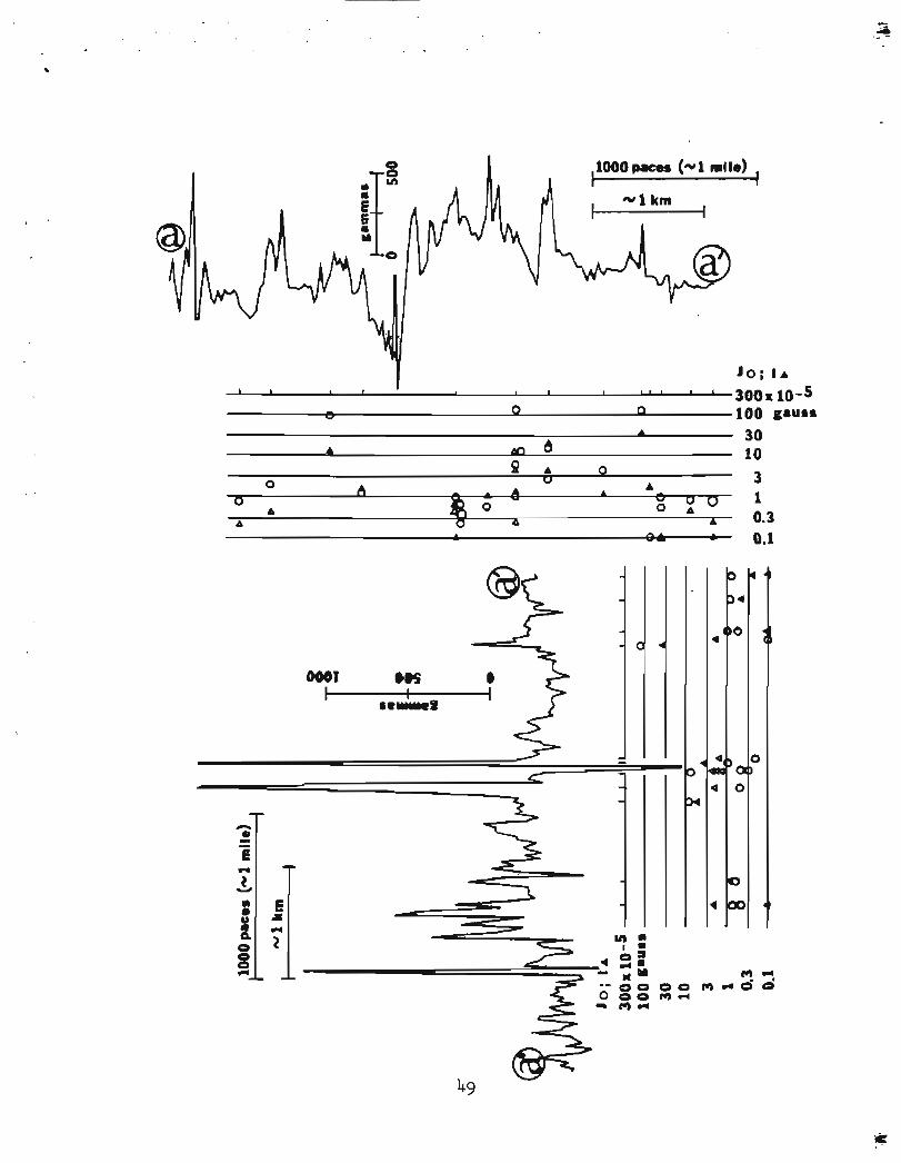
RESULTS OF GROUND MAGNETIC STUDIES
Locations of ground magnetometer t r a v e r s e s a r e shown by l i n e s a a '
through zz" and (as.') through ( j j") i n P l a t e 1, Dots a long these
l i n e s a r e sample s i t e s . A l l of the ground magnetometer p r o f i l e s , a t
an approximate s c a l e of 1 inch = 1 m i l e , a r e presented i n the appendix
along wi th graphs showing t h e s u s c e p t i b i l i t y and remanent magnetization
of samples c o l l e c t e d along t h e p r o f i l e s . I n add i t ion , ground
magnetometer p r o f i l e s from t h e d e t a i l e d study a r e a a r e presented a l l
together a t reduced s c a l e i n Figure 6.
Magnetic p r o p e r t i e s of rocks
Laboratory measurements of s u s c e p t i b i l i t y and remanent magnetization
were made on cores taken from about 300 hand spec.imens. I n add i t ion ,
s u s c e p t i b i l i t y was measured i n 12 s o i l samples taken beneath some of
t h e major aeromagnetic highs. The r e s u l t s of these measurements a r e
p l o t t e d a s histograms i n Figure 7. Two-thirds of t h e samples a r e from
t h e d e t a i l e d s tudy a r e a shown i n P l a t e 1; the r e s t a r e from neighboring
areas . An a t tempt was made t o sample a l l r e p r e s e n t a t i v e rock types.
Sampling was most in tense , however, i n t h e s c h i s t o s e metasedimentary
rocks which u n d e r l i e t h e major aeromagnetic highs.
S u s c e p t i b i l i t y of co res was measured i n an e x t e r n a l magnetic f i e l d
of 1,000 Hz and a peak amplitude of 0.5 oers ted (Hanna, W. F., w r i t t e n
commun., 1973). Most of t h e cores were d r i l l e d perpendicular t o
cleavage, and s u s c e p t i b i l i t y was measured only along t h i s d i r e c t i o n .
S u s c e p t i b i l i t y measured p a r a l l e l t o cleavage i n some of t h e cores with
2 3

higher s u s c e p t i b i l i t i e s was found t o he up t o 30 percent greater .
Hence, t h e average s u s c e p t i b i l i t y of the samples may be 10 t o 2Q percent
g r e a t e r than that indicated i n Figure 7. S u s c e p t i b i l i t y of s o i l
samples w a s measured i n a commercial s u s c e p t i b i l i t y bridge using a n
e x t e r n a l magnetic f i e l d of 1 , O Q O Hz and a peak amplitude of 1.0 oers ted .
Remanent magnetizat ion of the samples w a s measured i n a spinner
magnetometer described by Doell and Cox (1965).
-5 Magnetic modeling r e s u l t s show t h a t a magnetization of 140 x 10
gauss is needed t o exp la in aeromagnetic high A, which has a t y p i c a l
amplitude of 400 gammas. High B, with an amplitude of 500 t o 700
-5 gammas, r e q u i r e s a body w i t h magnetization ranging from 120 t o 430 x 10
gauss. Local peaks i n t h e ground magnetic p r o f i l e s shown i n Figures
3, 4, and 6 have amplitudes of 500 t o 2 , OQO gammas. These peaks are
caused both by inhomogenelties i n magnetic p r o p e r t i e s of t h e underlying
rocks and by l o c a l topographic e f f e c t s . Whatever t h e i r sources, these
l o c a l anomalies r e q u i r e magnetizat ions of 100 t o 1,000 x lo-' gauss.
Figure 7 shows that most of the rock samples a r e f a r too weakly
magnetic t o cause t h e observed aeromagnetic or ground magnetic highs.
-5 The g r e a t e s t s u s c e p t i b i l i t y measured is only 87 x 10 gausdoers ted .
-5 This s u s c e p t i b i l i t y y i e l d s an induced magnetization of 45 x 10 gauss
i n an ambient f i e l d of 0.55 oers ted . Only 11 samples have remanent
- 5 magnetizations g r e a t e r than 100 x 10 gauss. Only one of these samples
(from s t a t i o n 60 i n l i n e A1A2) under l i e s e i t h e r high A o r high B i n
P l a t e 1. Eight of t h e s e eleven magnetic samples occur under minor
aeromagnetic h ighs near Basin Creek and King Mountain (ground p r o f i l e s
uu' and yy' i n P l a t e 1 and Figure 6.
24
One reason why highly magnetic rocks w e r e not found is that high
A, and t o a l e s s e r ex ten t high B, occur over soil-covered s lopes which
have very few outcrops compared t o adjacent r idges. In d e t a i l , many
of t h e ground magnetic highs occur over grassy swalea, while lows
occur over adjacent outcrops. These observations suggest t h a t the
rocks which a r e magnetic a r e a l s o p a r t i c u l a r l y vulnerable t o erosion.
Another f a c t o r is suggested by t h e ve ry no i sy charac te r of many ground
magnetometer p r o f i l e s . Magnetic mate r i a l , ins tead of being uniformly
d i s t r i b u t e d throughout a massive body, may be concentrated in narrow
zones which are hard t o l o c a t e i n areas of poor exposures.
Even though h i g h l y magnetic rock w a s not found under highs A and
B, i t i s c l e a r t h a t t h e g ross rock u n i t o r u n i t s responsible f o r t h e
highs a r e represented by some of t h e samples. Samples w e r e taken i n
p laces where s t e e p magnetic g r a d i e n t s show t h a t magnetic rocks must
come t o wi th in 10 t o 30 metres of t h e surface . Many of t h e samples
contained abundant hematite. Prel iminary petrographic examination
of 25 t h i n s e c t i o n s by Travis Hudson (writ ten commun., 1972) showed
t h a t 10 t o 80 percent of t h e opaque minera ls i n hal f of t h e samples
a r e secondary and post-metamorphic. It is tempting t o specula te ,
pending a more thorough petrographic study, t h a t weathering has oxidized
magnetite t o hemati te near t h e su r face , and a t a depth of 20 t o 30
metres, f r e s h m a g n e t i t e i s present t o cause t h e magnetic anomalies.
Map of i n f e r r e d magnetic l i t h o l o g i e s
Three kinds of map p a t t e r n s i n t h e d e t a i l e d s tudy a r e a of P l a t e 1
show t h e i n f e r r e d ex ten t of outcropping bodies of highly and moderately
25

magnetized rock. Wherever poss ib le , ground magnetometer p r o f i l e s w e r e
used t o l o c a t e t h e boundaries of these rock bodies. The boundaries
were in te rpo la ted and ext rapola ted usfng t h e aeromagnetgc map.
Major exposures of magnetic rock under l i e Wghs A and B. In each
case the map p a t t e r n shows on ly t h e exposed t i p of a much l a r g e r body.
Lesser highs, poss ib ly covered by t h e same rocks t h a t produce magnetic
h igh A, a r e l abe led D i n P l a t e 1. Other lesser anomalies are labe led
E, F, G , H, I, and J. I n the following discussion, closed highs and
lows are i d e n t i f i e d by t h e gamma-value p r in ted a t t h e closure. A
north-south trending group of hfghs labeled D occurs over s c h i s t west
of high A. Ground magnetometer p r o f i l e s hbt and c c t over high D-685
a r e very noisy, s i m i l a r i n charac te r t o p r o f i l e s over highs A and B.
Hence, t h e i n f e r r e d magnetic rock u n i t under h i g h D i s shown w i t h - t h e
same map p a t t e r n a s t h a t used under h ighs A and B. High D c o d d be
caused by a v e r t i c a l prism of s c h i s t , inhomogeneous and highly magnetic
i n zones, s i m i l a r t o t h a t which causes high A. The amplitude of h igh
D is lower because t h e causat ive body ia only about one ki lometre wide.
Highs l abe led E, a l s o over s c h i s t , a r e much weaker than highs A o r D
and probably i n d i c a t e a d i f f e r e n t rock un i t . Ground magnetometer
p r o f i l e f f ' shows that h e r e t h e rocks are a n order of magnitude less
magnetic than those under high D-685. East of high A occurs another
group of highs, a l s o over s c h i s t , l abe led P, near ly a s high a s t h e
noise l e v e l s measured over h igh A, suggest ing t h a t high F could be
caused by small bodies of the same rock type which causes high A -
in fe r red source rocks of highs E and F a r e shown by i d e n t i c a l map
p a t t e r n s , but t h e rock types under them probably a r e not i d e n t i c a l .
26

Interspersed with t h e l o c a l h i g h labeled F, and a l s o over s c m s t ,
occur l o c a l lows labeled G. The east end of ground magnetometer
p r o f i l e wwt passes onto t h e south end 09 lowG-469. An abrupt
t r a n s i t i o n between high and low noise l e v e l s on the p r o f i l e ind ica tes
a boundary between magnetic and non-magnetic s ch i s t . The a l t e rna t i ng
pa t t e rn of highs labeled F and lows labeled G prohably de l inea tes
bodies of two d i f f e r e n t kinds of s c h i s t ,
Highs labeled H c o r r e l a t e q u i t e c l o s e l g w i t h t he upper c h l o r f t i c
s c h i s t labeled p6g on P l a t e 1. A l l mapped occurrences of p6g do not
produce aeromagnetic highs, however, so there must be more than one
var ie ty of p6g. The l a rges t occurrence of p6g with no associated
aeromagnetic high i s a t Newton Peak, 10 kLIometres nor theast of Nome.
Eight of t h e eleven samples i n which we found remanent magnetization
t o be g rea te r than 100 x 10" gauss came from t h e metagabbro un i t along
ground magnetometer p r o f i l e s uu' and yy'. Rocks with measured
remanent magnetizations of 100 t o 200 x gauss can e a s i l y produce
t h e ground magnetometer noise l e v e l s of 2QO t o 800 gammas observed
along these p ro f i l e s . Hand specimens of t h i s highly magnetic un i t
appear t o be f e l s i c metavolcanic rock. The patchiness of t he magnetic
highs suggests t h a t magnetic rock occurs a s i so la ted pods i n the p6g
uni t .
A low labeled B' n o r t h of high B is t h e compliinentary low t o high
B. It does not i nd i ca t e reversely magnetized rock.
Ground magnetometer p r o f i l e s xx' and yy' were made across a known
southwest- t o northeast-trending Anvil-Kunker f a u l t . This f a u l t
2 7

coincides with a l i nea t i on on the aeromagnetic map. The f a u l t occupies
zones of low no i se in hoth ground prof i l es , but the re is nothing i n
the p r o f i l e s which can be i den t i f i ed a s a magnetic "signaturet' of the
f a u l t .
A f a u l t containing sulfide-bearfng s c h i s t w a s located by a very
narrow, 2,000 gamma sp ike a t sample si.te 92 on ground magnetometer
p r o f i l e cc ' . The sp ike is so narrow t h a t it would barely be detectahle
i n an aeromagnetic survey.

SUMMARY AND CONCLUSZQNS
The western Seward Peninsula i s crossed by major north-south
s t ruc tu r e s , probably fo lds , which l o c a l l y br ing magnetic s c h i s t Ct he
g r aph i t i c lower s c h i s t ) c l o se t o t h e ground surface , causing north-south
trending aeromagnetic highs. These s t ruc tures , and t he magnetic
anomalies they cause, a r e truncated by t h e east-west trending Kigulafk
Mountains. J u s t south of t h e Kigluaiks, magnetic s c h i s t was upturned
and brought t o t h e sur face durrng the u p l i f t of t h e mountains. This
s c h i s t now gives r i s e t o a major east-west aeromagnetic high. The
in fe r red extent of outcrop of these magnetic bodies fa shown by a
hor izontal ly l i ned map pa t t e rn fn Pla t e 1.
Magnetic modeling shows t h a t one of the. north-south highs (A i n
P l a t e 1) is caused by t h e western edge of a th in , suhhorizontal
s lab- l ike body, while t h e east-west high south of the Kigluaiks (B i n
P l a t e 1 ) is caused by a body wi th deep roots . Both may contain the
same rock type, but they have undergone d i f f e r e n t kinds of deformation.
Aeromagnetic lows occur over carbonate rocks. The calcula ted
thickness of carbonate bodies causing lows is roughly one kilometre.
Thinner carbonate bodies, poss ibly t h r u s t sheets , do not produce
aeromagnetic lows.
None of more than 30Q rock samples co l lec ted had s u s c e p t i b i l i t i e s
h igh enough t o cause t he observed magnetic h ighs and less than 10 percent
of t he samples showed remanent magnetizations high enough t o cause t h e
observed anomalies. Most of the s t rongly magnetic samples were found
29

distant from the major aeromagnetic highs. Ground magnetometer profiles
showed, however, that highly magnetic rock lfes within 1Q to 30 metres
of the surface beneath aeromagnetrc highs. Possibly weathering has
oxidized magnetite to hematite in the top 10 to 30 metres.
REFERENCES
Andreasen, G. E., and Zie tz , I sadore , 1964, Magnetic f i e l d s f o r a
4 x 6 pr ismat ic model: U.S. Geol. Survey Prof. Paper 666, 9 p.,
210 p l .
Barnes, D. F., 1971, Prel iminary Bouguer anomaly and s p e c i f i c g r a v i t y
maps of Seward Peninsula and Yukon F l a t s , Alaska: U.S. Geol.
Survey open-f i le r e p o r t . Doell, R. R., and Cox, A., 1965, Measurement of the remanent
magnetizat ion of igneous rocks: U.S. Geol. Survey Bull. 203-A,
p. 1-32.
Hummel, C. L., 1960, S t r u c t u r a l geology and s t r u c t u r a l con t ro l of
mineral d e p o s i t s near Nome, Alaska, Short papers i n t h e
geological sciences: U.S. Geol. Survey Prof. Paper 400-B,
p. B30-B33.
, 1962a, Pre l iminary map of t h e Noma C-1 quadrangle, Seward
Peninsula, Alaska: U.S. Geol. Survey Mineral Inv. F ie ld S tud ies
Map, MF-247.
, 1962 b, Prel iminary geologic map of t h e Nome D-1 quadrangle,
Seward Peninsula, Alaska: U.S. Geol. Survey Mineral Inv. F ie ld
S tud ies Map, MF-248.
Johnson, G. R., and Sainsbury, C. L., 1974, Aeromagnetic and general ized
geologic map of the west-central p a r t of t h e Seward Peninsula,
Alaska: U.S. Geol. Survey Map GP-881.

Miller, T. P., Gryheck, D. G. , E l l i o t t , R. L. and Hudson, Travis , 1972,
Prel iminary geologic map of the. e a s t e r n Solomon and southeastern
Bendelen quadrangles, e a s t e r n Seward Peninsula, Alaska: U.S. Geol.
Survey open-fi le r e p o r t , s c a l e 1:250,QOQ.
Moff i t , F. H., 1913, Geology of the. Nome and Grand Centra l quadrangles,
Alaska: U.S. Geol. Survey Bull. 533, 14Q p.
Patton, W. W., Jr., and T a i l l e u r , 1. L., 1972, Evidence in t h e Bering
S t r a i t region f o r d i f f e r e n t i a l movement between North Amertca and
Eurasia: Abs. Geol. Soc. of h e r . 1932 Ann. Mtg., Nov., 1972.
Sainsbury, C. L., 1972, Geologic map of t h e T e l l e r quadrangle, western
Seward Peninsula, Alaska: U.S. Geol. Survey Misc. Geol. Inv. Map,
1-685.
, 1974, Geologic map of t he Bendelelien quadrangle, Seward
Peninsula, Alaska: Anchorage, AK, The Mapmakers, 31 p . ,
1:250,000 s c a l e map.
Sainsbury, C. L., Hummel, C. L., and Hudson, Travis , 1972,
Reconnaissance geologic map of t h e Nome quadrangle, Seward
Peninsula, Alaska: U.S. Geol. Survey open-file r epor t , 28 p.
Sainsbury, C. L., Hudson, Travis , Ewing, R., and Marsh, W. R., 1972a,
Reconnaissance geologic map of t h e west half of t h e Solomon
quadrangle, Alaska: U.S. Geol. Survey open-f i le r epor t , l a p.
, 1972b, Reconnaissance geologic maps of t h e Solomon D-5 and C-5
quadrangles, Seward Peninsula, Alaska: U. S. Geol. Survey open-f i l e
r e p o r t , 12 p.

Sainsbury, C. L., h d s o n , Travis , Ewing, R., and Richards, Thomas,
1972c, Reconnaissance geologic map of the Solomon D-6 quadrangle,
Seward Peninsula, Alaska: U.S. Geol. Survey open-fi le r e p o r t ,
17 p.
Smith, P. S., 1910, Geology and mineral resources of t h e solomon and
Casa de paga quadrangles, Seward Peninsula, Alaska: U.S. Geol.
Survey Bull . 433, 234 p.
Smith, P. S., and Eakin, H. M., 1911, A geologic reconnaissance i n
southeas tern Seward Peninsula and the Norton Bay-Nulato region,
Alaska: U.S. Geol. Survey Bull . 449, 146 p.
Talwani, M., and H e i r t z l e r , J. R., 1964, Computation of magnetic
anomalies caused by two dimensional s t r u c t u r e s of a r b i t r a r y shape,
i n Parks, G., ed., Computers i n t h e mineral indus t r i e s : Stanford, - Cal i f . , Stanford Univ., p. 464-480.
U.S. Geological Survey, 1969, Airborne geophysgcal surveys i n Seward
Peninsula a rea , Alaska: U.S. G e o l . Survey open-fi le repor t .
West, W. S., and Matzko, J. J., 1953, Reconnaissance f o r r ad ioac t ive
d e p o s i t s i n t h e v i c i n i t y of Cape None, 1947, Reconnaissance
f o r r a d i o a c t i v e d e p o s i t s i n the v i c b i t y of T e l l e r and Cape Nome,
Seward Peninsula, Alaska, 1946-47: U.S. Geol. Survey Circ. 244,
p. 5-8.


(I, a J a


Observed 2 Body 1
v gammas
0 0 0 Body 2 V
3L Depth (km) '3
FIGURE 5. TWO-DIMEIiSIONAL MRGNETIC MODEL ALONG PROFILE C 1 C rl FOR THE LOW OMR A CARBONATE BODY a I L
MAGNETIZATION OF COUNTRY ROCK (SCHIST) I S 4 2 x 1 0 ~ ~ GAUSS AROUND BODY 1 AND 6 3 ~ 1 O - ~ GAUSS
AROUND BODY 2 , JT I S INFERRED TOTAL MAGNETIZATION.

FIGURE 6, GROUND MGNETOllETER PROFILES ALONG TRAVERSE L I B SHOWN I N DETAILED STUDY AREA OF F I 6 U E 2, BENEATH PROFILES ARE GRAPHS SHOWING NUmERED SAMPLE LOCATIONS, M U R E D R€Mrm(T MAGNElIZATILN (CIRCLES). AND INDUCED MGNETIZATION COllPUTED FROM EASURU) SUSCEPTIBILITY (TRIANGLES).
SEE APPENDIX FOR EXPANDED VIEWS OF PROF1 LES .

n REMANENEWT
FIGURE 7, HISTOGRAM SHOWING EASURED REMNENT MAGNETIZATION AND SUSCEPTIBILITY, HACHURED AREAS INDICATE SPECIMENS WITH THE KONIGSBERGER RATIO Q (RATIO OF
REMANENT TO INDUCED MAGNETIZATION) GREATER THAN OR EQUAL TO 1 8 N I S THE TOTAL NUMBER OF SAMPLES, N I S THE NUMBER OF SAMPLES WITHIN THE INDICATED RANGE OF SUSCEPTIBILITY OR REMANENT MAGNETIZATIONJ K I S THE StJSCEPTIBILITYJ AND J THE REMANENT MAGNET1 ZATI ON,

IflE CONTAINS THE PROFILES AA' THROUGH zz' SHOWN I N FIGURE 6, AS WELL AS P q F I L E S (AA ' ) THROUGH (JJ") FROtl OUTSIDE THE DETAILED STUDY AREA. THE HORIZONTAL SCALE I S
APPROXIfIATELY 1 INCH 1 r ? I L E I THE SYMBOL o INDICATES MEASURED REMANENT MAGNETIZATION J; A I CATE.5 INDUCED PlAGlJETI Z A T I M COWUTED FROM MEASURED SUSCEPTI B I LITY AND THE EARTH'S MAGNETIC F I EL
M paces (-1 mile) I
I - 1 km
1
lo; la . I 100x10-5..us* A 30 0 10

1000 paces (-1 mile)
0 3 3 A 10
3 'd
A
& i 0.3
~3 0.1


,1000 paces (-1 mile) ,
Jo; l a
l o o 10-5 30 gauss 10 3 1 0.3 0.1
1000 paces (-1 mile)
J o ; l a
0 1000x 10'5~auss 300
Jo; l a 100 1 n 1 o x 10-5 8
3 gauss 30
0 1 .' A
A 0 10
f 3
0.3 a 1 A " e. 0.1 0.3

1000 paces (-1 mile)
1000 paces (- 1 mi le)
u I n 100 x 10-~~i,"s.
30 J 10

1000 paces (-1 mile)
0
0 ; l a
lox 10
9 3 gauss
A d u A 1 A
0 0.3 0.1
0 0 0 A 0 0
b 0 3 gauss
0 0 - A n 0 4 - A A A A
1
A 4 A A 0.3
* 0.1

0
1OOOp.ces (-1 mile)
I

(I) (I) 3

1000 paces (-1 mile)
10; [ A 1 , I r I t I
I * 300x10-5 -
V 0 0 100 gauss
A
A &, 4 30 10
Q A 0 0 u
A - A A A
3 0 " -
A 0 " 0 0 0 A
1 A o A A 0.3
A 04 0.1


OOS
I .el&.. f 3 * (I) 3 a M * 0
(I) (I) 3 (0 M
m