
THE INDUS BASIN: CHALLENGES AND RESPONSESwaterinfo.net.pk/sites/default/files/knowledge/The...
34
THE INDUS BASIN: CHALLENGES AND RESPONSES Madison Condon, Don Kriens, Anjali Lohani, Erum Sattar I. INTRODUCTION: HISTORIC CHALLENGES SHAPE THE PRESENT ........................................... 1 A. Building the Indus Basin Irrigation System (IBIS): From Desert to Fertile Lands ........2 B. Partition: Rivers Halve as Needs Multiply ...................................................................3 C. Waterlogging and Salinity: Too Much Water? .............................................................4 II. THE FACTS OF THE RIVER: NATURAL FEATURES, INFRASTRUCTURE, AND INSTITUTIONS .... 6 A. Physical Features of Basin...........................................................................................6 1. Geography and Demographics ...............................................................................6 2. Climate and Hydrology ..........................................................................................7 B. Infrastructure: Engineering the River ..........................................................................9 1. Agricultural Security: Distribution and Storage .....................................................9 2. Energy Security: Hydropower Capacity ............................................................... 10 3. Flood Security: Peak Reduction and Containment of Floodwaters ....................... 10 C. Institutions: Federalism Features and Governance Design of Basin .......................... 11 1. Federal Institutions .............................................................................................. 11 2. Federal Implementation ....................................................................................... 12 3. Provincial Implementation ................................................................................... 12 III. CONTEMPORARY CHALLENGES AND THEIR RESPONSES ................................................... 13 A. The Future of the Indus Water Treaty ........................................................................ 13 B. Managing Groundwater ............................................................................................. 14 C. Increasing Agricultural Productivity .......................................................................... 15 D. Adapting to Climate Change ...................................................................................... 17 E. Managing Floods....................................................................................................... 17 F. Environmental Flows ................................................................................................. 18 G. Infrastructure: Building New Storage ........................................................................ 19 IV. INSTITUTIONAL CHALLENGE OF THE PRESENT: 1991 WATER APPORTIONMENT ACCORD .. 20 A. Key Ambiguity in the Accord: Definition of Initial Conditions .................................... 21 B. Evolution of Interpretations of the Accord: 1991 to Present ....................................... 21 C. Current Sources of Inter-Provincial Mistrust ............................................................. 22 1. Exemption of Smaller Provinces from Sharing Shortages ..................................... 22 2. Three-Tier Method of Water Allocation................................................................ 23 3. Failure to Appeal to the Council of Common Interests ......................................... 23 4. Indus River System Authority ............................................................................... 24 a) Technical Issues ............................................................................................... 24 i. Water Availability Prediction: Provincial Politicization of Technical Task ...24 ii. Flow Monitoring: Federal Mandate Reliant on Provincial Cooperation ....... 24 iii. Increasing Conveyance Losses ...................................................................... 25 b) Institutional Issues............................................................................................ 25 i. Weak Enforcement Authority......................................................................... 25 ii. Lack of Funding and Subsequent Loss of Autonomy ...................................... 26 iii. Absence of an Overarching Regulatory Framework in the Water Sector ....... 26 D. Possible Next Steps: Increasing Transparency to Reduce Mistrust ............................. 27
-
Upload
duongthien -
Category
Documents
-
view
213 -
download
0
Transcript of THE INDUS BASIN: CHALLENGES AND RESPONSESwaterinfo.net.pk/sites/default/files/knowledge/The...

THE INDUS BASIN: CHALLENGES AND RESPONSES
Madison Condon, Don Kriens, Anjali Lohani, Erum Sattar
I. INTRODUCTION: HISTORIC CHALLENGES SHAPE THE PRESENT ........................................... 1 A. Building the Indus Basin Irrigation System (IBIS): From Desert to Fertile Lands ........2
B. Partition: Rivers Halve as Needs Multiply ...................................................................3 C. Waterlogging and Salinity: Too Much Water? .............................................................4
II. THE FACTS OF THE RIVER: NATURAL FEATURES, INFRASTRUCTURE, AND INSTITUTIONS .... 6 A. Physical Features of Basin...........................................................................................6
1. Geography and Demographics ...............................................................................6 2. Climate and Hydrology ..........................................................................................7
B. Infrastructure: Engineering the River ..........................................................................9 1. Agricultural Security: Distribution and Storage .....................................................9
2. Energy Security: Hydropower Capacity ............................................................... 10 3. Flood Security: Peak Reduction and Containment of Floodwaters ....................... 10
C. Institutions: Federalism Features and Governance Design of Basin .......................... 11 1. Federal Institutions .............................................................................................. 11
2. Federal Implementation ....................................................................................... 12 3. Provincial Implementation ................................................................................... 12
III. CONTEMPORARY CHALLENGES AND THEIR RESPONSES ................................................... 13 A. The Future of the Indus Water Treaty ........................................................................ 13
B. Managing Groundwater ............................................................................................. 14 C. Increasing Agricultural Productivity .......................................................................... 15
D. Adapting to Climate Change ...................................................................................... 17 E. Managing Floods ....................................................................................................... 17
F. Environmental Flows ................................................................................................. 18 G. Infrastructure: Building New Storage ........................................................................ 19
IV. INSTITUTIONAL CHALLENGE OF THE PRESENT: 1991 WATER APPORTIONMENT ACCORD .. 20 A. Key Ambiguity in the Accord: Definition of Initial Conditions .................................... 21
B. Evolution of Interpretations of the Accord: 1991 to Present ....................................... 21 C. Current Sources of Inter-Provincial Mistrust ............................................................. 22
1. Exemption of Smaller Provinces from Sharing Shortages ..................................... 22 2. Three-Tier Method of Water Allocation ................................................................ 23 3. Failure to Appeal to the Council of Common Interests ......................................... 23
4. Indus River System Authority ............................................................................... 24 a) Technical Issues ............................................................................................... 24
i. Water Availability Prediction: Provincial Politicization of Technical Task ... 24 ii. Flow Monitoring: Federal Mandate Reliant on Provincial Cooperation ....... 24
iii. Increasing Conveyance Losses ...................................................................... 25 b) Institutional Issues ............................................................................................ 25
i. Weak Enforcement Authority ......................................................................... 25 ii. Lack of Funding and Subsequent Loss of Autonomy ...................................... 26
iii. Absence of an Overarching Regulatory Framework in the Water Sector ....... 26 D. Possible Next Steps: Increasing Transparency to Reduce Mistrust ............................. 27

1. Improve Water Availability Predictions................................................................ 27 2. Establish Independent Monitoring........................................................................ 27
3. Formalize Water Trading ..................................................................................... 27 4. Modernize Sharing of Hydropower Royalties ....................................................... 28
V. CONCLUSION .................................................................................................................. 28
Indus Basin – 1
I. INTRODUCTION: HISTORIC CHALLENGES SHAPE THE PRESENT
The construction of the Indus Basin Irrigation System beginning in the mid-nineteenth
century forever changed the fate of the Indus Basin. The previously untamed Indus and its
tributaries, rising from the glaciers of the western Himalayas and meandering through the
southern plains, adding layer upon layer of fertile sediment on its way to the Arabian sea, were
brought for the first time under human guidance into a system of weirs, levees, and canals. As
the availability of water transformed deserts into fertile agricultural fields, this mostly
uninhabited land saw an influx of human settlers which thrived and flourished into what today
has become one of the most populated regions in the world.
Not all was brought under human control however, and droughts and floods continue to
test the inhabitants of the Basin. The challenges of the basin have increased manifold from a
mere deficiency of water to now include the uncertainties of climate change, previously ignored
environmental needs, the political economy of international boundaries, and compounding
mistrust between Pakistan’s own provinces. A functional institutional structure is in place in the
Basin, with authorities at the federal level creating broad spanning directives and agencies at the
provincial level implementing programs within their jurisdictions, however there are multiple
opportunities for institutional improvement which perhaps will facilitate the infrastructural
updates necessary to overcome the challenges of the 21st century.
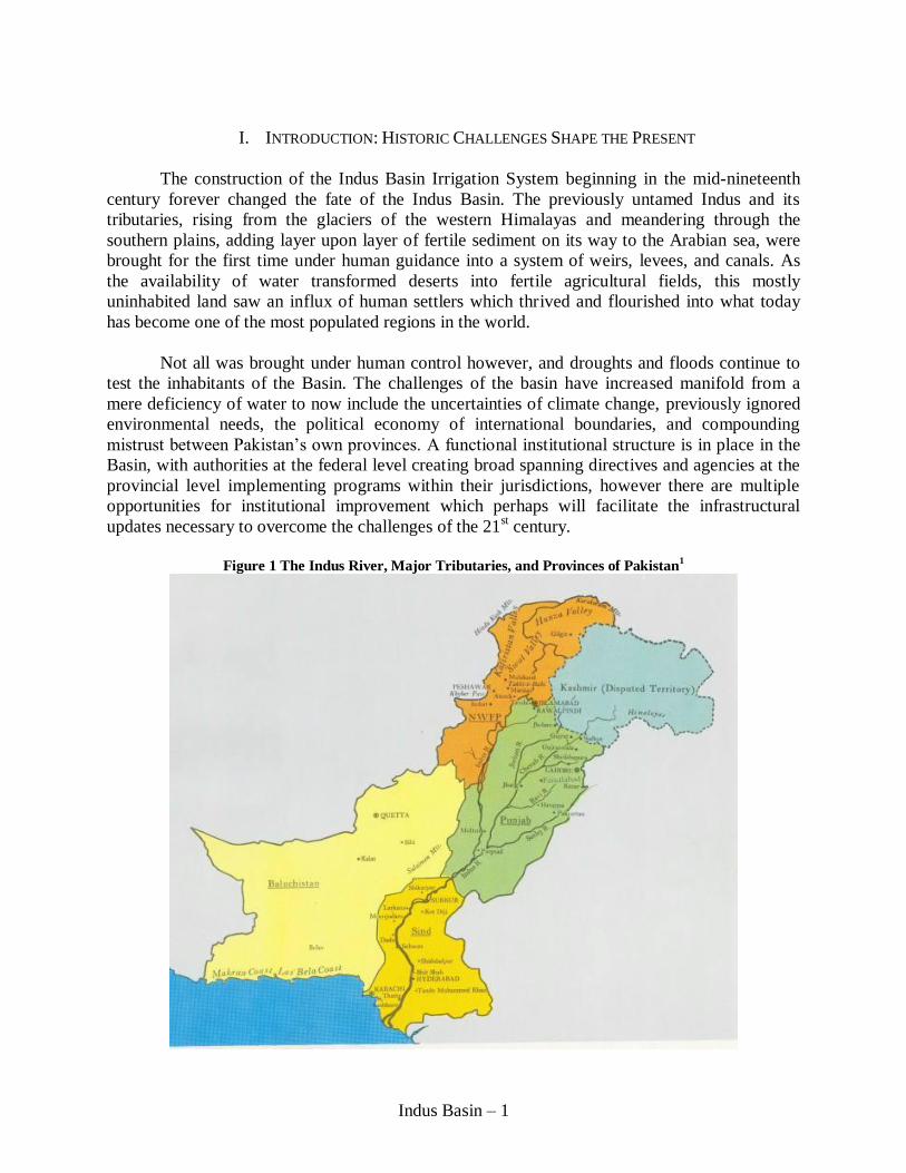
Figure 1 The Indus River, Major Tributaries, and Provinces of Pakistan
1
Indus Basin – 2
A. Building the Indus Basin Irrigation System (IBIS): From Desert to Fertile Lands
The Indus River has long been a source of plentiful agriculture in the otherwise desert-
like region that largely comprises Pakistan today. In its natural state, the central and southern
plains of the Indus Basin are extremely arid and the rainfall received is not sufficient for growing
crops. Water from the Indus provided the vital supplement that allowed agriculture to flourish
early on along the banks of the river, as evidenced by remains of the Indus Valley Civilization,
one of the oldest civilizations of the world. Centuries after this civilization became extinct, an
estimated 5 to 6 centuries ago, the Mughal Emperors built the first canals in the Basin.2 Unlike
modern day canals, these were inundation channels which received water when river flows were
high and remained dry when flows were low. A few perennial inundation canals were designed;
however these were meant for carrying water to imperial forts and gardens in present-day Lahore
rather than for irrigating agricultural fields.3
The annexation and consolidation of Punjab into British India in 1849 set the stage for
constructing an extensive canal system that shaped the present day Indus Basin Irrigation
System.4 Via a system of “agricultural colonization,” the British claimed swaths of unsettled
desert for the Crown while ignoring ownership of pastoralist tribes. They developed an extensive
system of weirs and barrages to restrain the powerful Indus waters which naturally meandered
over large areas of previously uninhabited desert. Plots of land in the command of the new canal
system, both in present day Punjab and Sindh, were then awarded to be resettled and cultivated
by the former Punjabi army in return for their loyalty to the British.5 This preferential treatment
began sowing mistrust between the Punjabis and other ethnicities, a problem that perpetuates
today. To complicate the situation further, most of the land grants went to non-Muslim Punjabis,
a source of upheaval during the migration that preceded Partition in 1947.6 However, on the
productivity front, containment of the river and irrigated cultivation was a huge success as the
Punjabi colonists dramatically improved the productivity of the land, improved drought-time
food security, and to the delight of the British, transformed canal command into a valuable
source of taxes.7
Along with building extensive infrastructure, the British also introduced an institutional
framework based on land rights. Irrigators in the canal colonies operated under a warabandi
system in which each farm on a watercourse was allocated a withdrawal time window on a
rotating schedule. The duration of supply to each landowner was proportional to the size of his
landholding in the command, a principal that assumed a constant rate of flow in the canals.
However, flow rates fluctuated significantly according to time and location, resulting in
individual landowners receiving widely variable amounts of water. The warabandi system was
formalized by the 1873 Irrigation Act and is still used today by the provincial irrigation
departments to distribute water. Supply inequity along the watercourse continues due to the
absence of two factors: flow gauges and storage capacity to monitor and smoothen flow rates.
The canals were unlined, meaning that the system experienced heavy conveyance losses
over the 56,000 kilometers that they traversed. Studies estimate that when field application losses
were factored in, only 45 percent of the water captured at the canal head was available to crops.8
Up until today, the canals remain unlined and losses are not fully accounted for in the warabandi

Indus Basin – 3
schedule. This means that users at the ‘tail end’ of the canals are regularly shorted on their
allocated share of water, a systematic deficiency of the world’s largest contiguous irrigation
system.
Despite its weaknesses, the construction of the extensive irrigation system was able to
transform the fears of ‘not enough water’ into the promise of ‘plenty’. What began as settlement
of the canal colonies subsequently led to more ambitious projects such as the Triple Canal
Project and the Sutlej Valley Project that shifted entire rivers of water, thus planting the seed for
the response to the soon to come challenge of partition of British India.
B. Partition: Rivers Halve as Needs Multiply
The Indian Independence Act of 1947, which dissolved the British Raj, divided former
India into two independent sovereignties of Pakistan, an Islamic state, and India, a secular one.
As a result of the hastily drawn line separating the two countries, almost 90 percent of the
irrigated land of the Indus River Basin fell in Pakistan’s territory. The tributaries to the Indus
however, originated in Tibet and flowed through India before entering Pakistan. For two
countries that had gone to war after partition over disputed territory in Kashmir, this was not a
small problem.
Immediately after partition, the Inter-Dominion Accord of 1948 served as a temporary
agreement to govern the allocation of the Indus waters between the two countries. The Accord
merely called for India to release “sufficient” amounts of water to Pakistan. This ambiguous
terminology threatened Pakistanis, who feared that India could destroy Pakistan’s agricultural
economy while still remaining within legal limits. As Pakistan’s attempt to bring the dispute to
the International Court of Justice failed due to lack of Indian cooperation, the international
community, facilitated by The World Bank, stepped in to conduct a decade of negotiations which
culminated in the signing of the Indus Waters Treaty (IWT) in 1960.
The IWT delineated the sharing of water from the Indus and its tributaries as follows: the
three “western” rivers – Indus, Jhelum, and Chenab – comprising 75 percent of the waters in the
Basin, were given to Pakistan, while exclusive rights to the three “eastern” rivers – Ravi, Beas,
and Sutlej – were given to India. During the negotiations, the two countries advanced competing
principles of water law to support their claims to a greater share of the resource. India objected to
the assigning of 75 percent of the waters to Pakistan on the principle of ‘equitable utilization.’
Pakistan, which had 90 percent of the irrigated land on its side, argued its allocation of only 75
percent of the water went against the principle of ‘no appreciable harm.’ Nevertheless, the two
countries agreed to allow principles of engineering and economics to drive the process rather
than using legal considerations. Subsequently, the IWT allowed India, under strict conditions, to
tap the considerable hydropower potential of the three western rivers before they entered
Pakistan, a practicality that has become as significant challenge for Pakistan in the present day as
will be discussed later.
Despite containing significant compromises for both parties, the completion and
acceptance of the IWT from both sides speaks to its success. Pakistan’s President at the time,
Ayub Khan, summed up his country’s support of the final product by saying, “we have been able
Indus Basin – 4
to get the best that was possible – very often the best is the enemy of the good and in this case,
we have accepted the good after careful and realistic appreciation of our entire overall situation –
the basis of this agreement, is realism and pragmatism.”9 The success of the treaty is
demonstrated by the fact that it has not been revoked by either country despite three post-
partition Indo-Pakistan wars. The Indus River Commission, which was established to mediate
and resolve disputes arising over the implementation of the treaty, has not been call upon.
However, the Commission continues to organize annual infrastructure inspections and facilitate
data exchange between the two nations.
The Indus Basin Replacement Works (IBRW) plan was worked out as part of the IWT to
enable Pakistan to supply water to those areas no longer irrigated by the eastern rivers. Pakistan’s
newly created and widely admired public utility – the Water and Power Development Authority
(WAPDA) – oversaw the implementation of the IBRW. Under the IBRW, Tarbela dam and
Mangla dam were constructed on the Indus and the Jhelum respectively and eight massive ‘link
canals’ were built to channel water from the western rivers to the now dry eastern rivers. At the
time of its completion in 1976, Tarbela was the largest earth-fill dam in the world. 10
Six major
diversion barrages were also completed as part of IBRW. The massive construction was financed
by the Indus Basin Development Fund, which comprised of contributions from several western
governments, a payment from India, and loans from The World Bank. Tarbela and Mangla were
only the beginning of a vast array of planned storages on the Indus and its tributaries, as put
forward in the 1968 report commissioned by The World Bank titled Water and Power Resources
of West Pakistan: A Study in Sector Planning, popularly known as the Lieftnick Report, and
intended backbone of Pakistan’s water sector strategy for the coming decade. The halving of
Pakistan’s rivers and the IWT thus created the political opening to commence on a colossal plan
to modify the country’s hydraulic engineering and build a platform for economic growth and
security.
C. Waterlogging and Salinity: Too Much Water?
The IBIS brought water that was vital to transforming the parched lands of the Indus
Basin into highly productive fields. The possibility of over-irrigation however, appears to not
have been seriously considered while this extensive network of canals was being constructed. As
it turned out, over-irrigation severely disturbed the Basin’s water balance, causing a
waterlogging and salinity nightmare.
The fact that the canal network was unlined meant that, over time, hundreds of billions of
cubic meters of water seeped into the underlying groundwater aquifer.11
Since the water table
was naturally 20-30 meters below the soil surface, the main concern during the construction
phase was loss of water for surface irrigation; neither did the rising water table raise any red
flags, nor was the need for a drainage system was considered a priority.12
However, intense
irrigation and a naturally flat topography featuring no surface or sub-surface drainage altered the
existing water balance and raised the groundwater table dramatically by the mid 20th century, as
illustrated in the cross section between the Punjab canals shown in Figure 2.
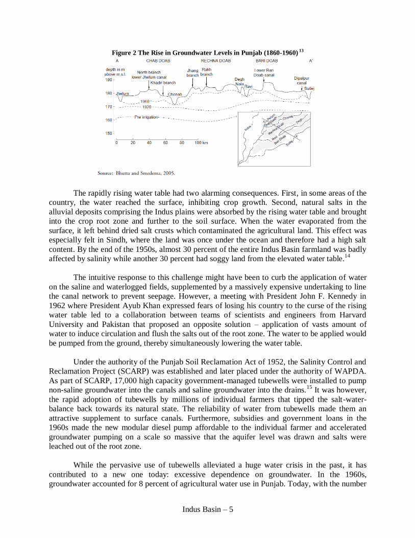
Indus Basin – 5
Figure 2 The Rise in Groundwater Levels in Punjab (1860-1960) 13
The rapidly rising water table had two alarming consequences. First, in some areas of the
country, the water reached the surface, inhibiting crop growth. Second, natural salts in the
alluvial deposits comprising the Indus plains were absorbed by the rising water table and brought
into the crop root zone and further to the soil surface. When the water evaporated from the
surface, it left behind dried salt crusts which contaminated the agricultural land. This effect was
especially felt in Sindh, where the land was once under the ocean and therefore had a high salt
content. By the end of the 1950s, almost 30 percent of the entire Indus Basin farmland was badly
affected by salinity while another 30 percent had soggy land from the elevated water table.14
The intuitive response to this challenge might have been to curb the application of water
on the saline and waterlogged fields, supplemented by a massively expensive undertaking to line
the canal network to prevent seepage. However, a meeting with President John F. Kennedy in
1962 where President Ayub Khan expressed fears of losing his country to the curse of the rising
water table led to a collaboration between teams of scientists and engineers from Harvard
University and Pakistan that proposed an opposite solution – application of vasts amount of
water to induce circulation and flush the salts out of the root zone. The water to be applied would
be pumped from the ground, thereby simultaneously lowering the water table.
Under the authority of the Punjab Soil Reclamation Act of 1952, the Salinity Control and
Reclamation Project (SCARP) was established and later placed under the authority of WAPDA.
As part of SCARP, 17,000 high capacity government-managed tubewells were installed to pump
non-saline groundwater into the canals and saline groundwater into the drains.15
It was however,
the rapid adoption of tubewells by millions of individual farmers that tipped the salt-water-
balance back towards its natural state. The reliability of water from tubewells made them an
attractive supplement to surface canals. Furthermore, subsidies and government loans in the
1960s made the new modular diesel pump affordable to the individual farmer and accelerated
groundwater pumping on a scale so massive that the aquifer level was drawn and salts were
leached out of the root zone.
While the pervasive use of tubewells alleviated a huge water crisis in the past, it has
contributed to a new one today: excessive dependence on groundwater. In the 1960s,
groundwater accounted for 8 percent of agricultural water use in Punjab. Today, with the number

Indus Basin – 6
of private tubewells exceeding 920,000, that figure is more than 60 percent.16,17
Since
precipitation is the Basin is so low, seepage from the canals is the primary aquifer recharge
mechanism. In many parts of Punjab however, the rate of groundwater pumping is too high to
maintain aquifer levels. In parts of Balochistan, farmers drill more than 1000 feet to reach the
water table while in Lahore, the water table has been falling half a meter per year for the past
three decades.18
Supplementing canal water with groundwater is less common in Sindh, where
the groundwater is naturally more brackish, and over-irrigation perpetuates the salinity problem.
In this sense, has the historical problem of too little water transformed to one of too much water?
II. THE FACTS OF THE RIVER: NATURAL FEATURES, INFRASTRUCTURE, AND INSTITUTIONS
A. Physical Features of Basin
1. Geography and Demographics
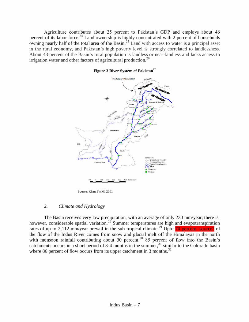
The Indus Basin in Pakistan drains an area of 566,000 km2, about 70 percent of the
country, comprising the whole of the provinces of Punjab, Sindh, Khyber Pakhtun Khwa (KPK;
known previously as the North-West Frontier Province), and the eastern part of Balochistan.19
The Indus basin is fed by the Indus River and its five tributaries, the western rivers of Kabul,
Jhelum and Chenab, and the eastern rivers of Ravi, and Sutlej. As shown in Figure 3, the Indus
River stretches 2,900 kilometers from altitudes of up to 18,000 ft in the Himalayan mountains in
the north to low gradient areas in the southern delta of Sindh, where it discharges into the
Arabian Sea.
The Indus Basin is primarily an agricultural basin. Although twelfth largest among the
world’s drainage basins, its irrigation network, the Indus Basin Irrigation System (IBIS), is by far
the largest contiguous irrigation system in the world. About 190,000 km2 of cropland are
irrigated in the Indus plains, 150,000 km2 by the IBIS and 40,000 km
2 by local irrigation
systems.20
The relatively flat basin consists of homogeneous, deep, fine grained, fertile and very
permeable soils deposited by the Indus and its tributaries. Underlying the Basin is a highly
transmissive groundwater aquifer that is heavily relied upon to augment IBIS irrigation water.
The fifth largest delta and the seventh largest mangrove system in the world lie within the
Indus Basin. The delta ecosystem has deteriorated in recent decades due, in part, to a lack of
sustained minimum river flows. There are large areas of highly saline soils that limit crop
production, significant salt water intrusion, and fisheries and mangrove depletions. Water
pollution in the delta is extensive due to inadequate sewage treatment.
Pakistan’s population is the world’s sixth largest, currently at about 173 million, and
expected to reach 220 million by year 2025.21
80 percent of all Pakistanis live in the Basin, which
occupies about 20 million hectares.22
60 percent of the basin population is rural with a trend that
urban populations will, in time, exceed rural.23
Accordingly, the basin rural population density is
high at about 414 persons/km2, as compared to the Mississippi River Basin mean population
density of 6 persons/km2. High population growth has placed Pakistan at the brink of being a
“water scarce” country, with water availability currently at about 1,000 cubic meters/capita.
Indus Basin – 7
Agriculture contributes about 25 percent to Pakistan’s GDP and employs about 46
percent of its labor force.24
Land ownership is highly concentrated with 2 percent of households
owning nearly half of the total area of the Basin.25
Land with access to water is a principal asset
in the rural economy, and Pakistan’s high poverty level is strongly correlated to landlessness.
About 43 percent of the Basin’s rural population is landless or near-landless and lacks access to
irrigation water and other factors of agricultural production.26
Figure 3 River System of Pakistan27
2. Climate and Hydrology
The Basin receives very low precipitation, with an average of only 230 mm/year; there is,
however, considerable spatial variation.28
Summer temperatures are high and evapotranspiration
rates of up to 2,112 mm/year prevail in the sub-tropical climate.29
Upto 70 percent- source? of
the flow of the Indus River comes from snow and glacial melt off the Himalayas in the north
with monsoon rainfall contributing about 30 percent.30
85 percent of flow into the Basin’s
catchments occurs in a short period of 3-4 months in the summer,31
similar to the Colorado basin
where 86 percent of flow occurs from its upper catchment in 3 months.32
Source: Khan, IWMI 2001
Indus Basin – 8
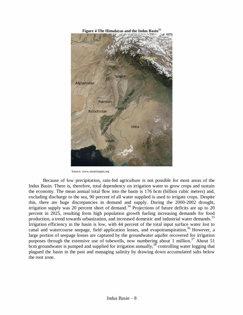
Figure 4 The Himalayas and the Indus Basin33
Because of low precipitation, rain-fed agriculture is not possible for most areas of the
Indus Basin. There is, therefore, total dependency on irrigation water to grow crops and sustain
the economy. The mean annual total flow into the basin is 176 bcm (billion cubic meters) and,
excluding discharge to the sea, 90 percent of all water supplied is used to irrigate crops. Despite
this, there are huge discrepancies in demand and supply. During the 2000-2002 drought,
irrigation supply was 20 percent short of demand.34
Projections of future deficits are up to 20
percent in 2025, resulting from high population growth fueling increasing demands for food
production, a trend towards urbanization, and increased domestic and industrial water demands.35
Irrigation efficiency in the basin is low, with 44 percent of the total input surface water lost to
canal and watercourse seepage, field application losses, and evapotranspiration.36
However, a
large portion of seepage losses are captured by the groundwater aquifer recovered for irrigation
purposes through the extensive use of tubewells, now numbering about 1 million.37
About 51
bcm groundwater is pumped and supplied for irrigation annually,38
controlling water logging that
plagued the basin in the past and managing salinity by drawing down accumulated salts below
the root zone.
Source: www.nasaimages.org
Indus Basin – 9
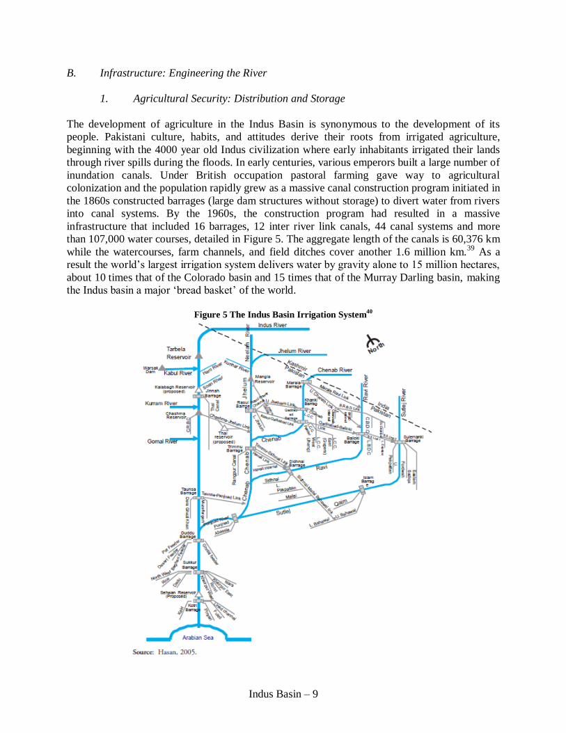
B. Infrastructure: Engineering the River
1. Agricultural Security: Distribution and Storage
The development of agriculture in the Indus Basin is synonymous to the development of its
people. Pakistani culture, habits, and attitudes derive their roots from irrigated agriculture,
beginning with the 4000 year old Indus civilization where early inhabitants irrigated their lands
through river spills during the floods. In early centuries, various emperors built a large number of
inundation canals. Under British occupation pastoral farming gave way to agricultural
colonization and the population rapidly grew as a massive canal construction program initiated in
the 1860s constructed barrages (large dam structures without storage) to divert water from rivers
into canal systems. By the 1960s, the construction program had resulted in a massive
infrastructure that included 16 barrages, 12 inter river link canals, 44 canal systems and more
than 107,000 water courses, detailed in Figure 5. The aggregate length of the canals is 60,376 km
while the watercourses, farm channels, and field ditches cover another 1.6 million km.39
As a
result the world’s largest irrigation system delivers water by gravity alone to 15 million hectares,
about 10 times that of the Colorado basin and 15 times that of the Murray Darling basin, making
the Indus basin a major ‘bread basket’ of the world.
Figure 5 The Indus Basin Irrigation System
40

Indus Basin – 10
In spite of the Basin’s massive distribution network, its storage capacity is very low, at
only about 30 days worth of annual flow, contained mostly in two reservoirs. This is some 30
times less than the storage capacities of the Murray Darling and Colorado Basins. Limited
storage places a severe constraint in assuring that supply will meet demand, since the majority of
flow occurs during just a few months. Lack of storage also limits the flexibility of providing a
sustained minimum flow at the delta needed to maintain a healthy ecosystem. Although storage
is urgently needed to accommodate drought periods and attenuate flooding, the last reservoir was
constructed over three decades ago in 1976.
2. Energy Security: Hydropower Capacity
Pakistan currently generates approximately 6,500 MW of hydropower a year; at a total
generation potential of 60,000 MW, the country’s hydropower is massively underdeveloped.41
The total installed hydropower generation capacity in Pakistan was around 21,600 MW in 2010,
with demand increasing by roughly 7 percent annually. The supply of electricity falls short of
demand by 2,000–4,000 MW.42
Daily power rationing, known as ‘load shedding’, is common
due to generation deficits and poor transmission capability. Blackouts as long as 8–10 hours per
day are frequent in cities hours are often double that in rural areas.43
Despite having a high potential for development of low cost hydropower Pakistan highly
depends on imported oil for electricity production. About 39 percent of all electricity is produced
by oil-fired thermal generating plants.44
Oil is expensive and places considerable strain on the
economy by raising the external current account deficit and worsening the country's balance of
payments position.45
Development of available hydropower by building additional dams would
lessen this burden while simultaneously providing much needed supplementary capacity for
irrigation storage and flood control.
3. Flood Security: Peak Reduction and Containment of Floodwaters
With regularity, flooding in the basin has caused loss of life in large numbers with massive
damage to infrastructure and crops. Consecutive floods have resulted in long term disruption of
productive agriculture and economic development. Since 1950, over 17 major floods have
occurred with an estimated cumulative damage of over $15 billion in direct economic losses,
nearly 9,000 lives lost, and millions of acres flooded.46
Past floods were eclipsed in magnitude
by the 2010 flood, worst in Pakistan’s history, with an estimated 2000 deaths, nearly 20 million
people displaced, and estimated economic damages of $2.9 billion to the agricultural sector
alone.47
In 2010, after a prolonged period of drought, unprecedented widespread heavy rains in
upper catchments resulted in extremely high runoff in a short period of time. Rainfall of such
high intensity and short duration had never been observed at many of the gauging stations in the
north of country, with high intensity instantaneous flood peaks at various locations on rivers
surpassing historic peaks recorded in the past.
Indus Basin – 11
Figure 6 Flood Impacts in the Indus Basin48
With climate change, unusual rainfall patterns are expected to become more common.
The IPCC predicts substantial increases in extreme precipitation events, although the number of
rainy days would decrease.49
Climate scientists also project short-term increases in Himalaya de-
glaciation, causing increased flows of an estimated 30-40 percent in the Basin in the next 50
years, followed by long-term flow reductions of an estimated 30-40 percent.50
Although there is
great uncertainty in climate projections it is clear that high variability is very likely, both in
droughts and floods.
In Sindh and Punjab, flow protection embankments and spurs (to guide flow through
barrages) were constructed to protect irrigation infrastructure and reduce river overflows. Some
non-structural programs, including improved flood forecasting, were also initiated.51
But
embankment remedies are difficult to sustain since high rates of siltation continue to raise river
beds. In some areas bed elevations exceed surrounding terrain, greatly increasing the likelihood
of breaching embankments during high flows. Siltation has also reduced the capacities of the
three reservoirs – Tarbela, Mangla, and Chasma – in the Indus system. Although it is impossible
to eliminate the threat of all flooding, it is important to both build more storage infrastructure and
conduct more non-structural programs to build the capacity to attenuate dangerous high flows
and harness water during times of excess to provide for times of drought.
C. Institutions: Federalism Features and Governance Design of Basin
1. Federal Institutions
The 1873 Irrigation Act was the first water distribution institution in the Indus Basin. The
warabandi system of water distribution formalized by the Act – in which each farm on a
watercourse is allotted a withdrawal time window based on its landholding size – continues to be
the primary mechanism of distributing water on the individual farmer scale today. At the
provincial level, water distribution methods have gone through a series of changes. After
Pakistan’s independence from Britain in 1947, irrigation water was allocated between provinces
based on informal ad-hoc arrangements. A much more consistent method was introduced in 1991
when the federal government instituted the Water Apportionment Accord (hereafter referred to
as ‘the Accord’).The Accord provides guidelines to determine the size of the allocations to each

Indus Basin – 12
province at the start of the kharif season (the wet summer months) and the rabi season (the dry
winter months) based on the province’s historical uses and designated share of shortages or
surpluses. However, different provinces have their own interpretations of the clauses that spell
out the distribution percentages; fueled by mistrust and ethnic conflict, this disagreement is at the
core of many implementation problems in the Indus Basin, as to be described in later sections.
2. Federal Implementation
After the Accord was passed, the Indus River System Authority (IRSA) was formed in
1992 to implement the provisions of the Accord and determine the seasonal shares of water to be
distributed among the provinces. IRSA is a federal body that is comprised of four provincial
representatives, one from each province, and a federal nominee.
IRSA works closely with the Water and Power Development Authority (WAPDA).
WAPDA is a federal agency established in 1958 by the West Pakistan Water and Power
Development Authority Act. It is responsible for formulating a national water resources
development strategy, operating and maintaining large inter-provincial water infrastructures
including dams and reservoirs, developing and distributing hydro and thermal power, and
resolving issues like water logging and salinity. WAPDA also estimates how much water might
be available to the system in the upcoming season; IRSA uses these estimates while making
water allocation decisions.
3. Provincial Implementation
Within the provinces, water management is the responsibility of Provincial Irrigation
Departments and Provincial Irrigation and Drainage Authorities (PIDAs). PIDAs inform
WAPDA of provincial water demands for specific locations. WAPDA then releases water from
reservoirs to meet demands as closely as possible. The provinces are authorized to modify
system-wise and period-wise uses within the provincial allocations.
Before the PIDAs were established, water was managed at the watercourse level by
Water User Associations. In 1997 each province passed an Irrigation and Drainage Authority Act
at the province-level to introduce institutional reforms in the irrigation and drainage sectors. This
Act was meant to provide the legal framework for operating PIDAs as well as to establish Area
Water Boards (AWBs) and Farmers Organizations (FOs) on a pilot basis in selected canal
commands. AWBs and FOs were to be responsible for ensuring equitable distribution of water
among users and for resolving disputes. However, progress on these reforms has been slow due
to controversy over irrigation reforms among implementing agencies and the vast majority of
irrigation schemes are still operated and maintained by the provincial governments in the
traditional manner.52
Indus Basin – 13
III. CONTEMPORARY CHALLENGES AND THEIR RESPONSES
Pakistan’s water security faces numerous contemporary challenges. Some of these
challenges have arisen as result of human interventions made to overcome historical challenges,
others due to changing demographics and political pressures in the region, and yet others have
come to our attention due to improvements in our knowledge and understanding of interactions
between hydrology and ecology. A common theme that runs across these challenges is the
discord between institutions and their implementation, which often manifest due to one or more
of the following reasons: historical animosities across international and provincial borders;
superiority of legality over practicality in Pakistan; short-sightedness in policy choices; and
often, lack of political will.
While we briefly describe each of these present day challenges, the bulk of this paper’s
focus will be on managing the 1991 Water Apportionment Accord firstly, because the Water
Accord is the key to federal-state interaction on water management in the country and therefore
at the crux of water federalism in Pakistan, and secondly, managing the Water Accord in a
transparent way that shares benefits equitably among provinces will perhaps enable the provinces
to push water as a national priority and together enact the responses needed to overcome the
remaining gamut of challenges.
A. The Future of the Indus Water Treaty
The future of the Indus Water Treaty presents a trans-boundary challenge for Pakistan’s
water security. The IWT has, for the most part, been very successful. A clear definition of
entitlements monitored by both countries and a clear set of enforcement mechanisms have
allowed the treaty to survive three wars between India and Pakistan. However, as new
technological developments have been made, different interpretations of certain parts of the
treaty have surfaced. Four decades after the treaty was written, for the first time, the Indus River
Commission was unable to work with India and Pakistan to resolve one issue – the design of the
Baglihar Dam on the Chenab River.
The IWT allows India to make non-consumptive use of the western rivers before they
enter Pakistan. Strict limits are placed on live storage in India to protect Pakistan in terms of both
flow timing and quantities. When India designed the Baglihar Dam to be built on the Chenab,
Pakistan deemed that the spillways were at a height lower than that agreed upon by the two
countries in the IWT, thereby increasing the reservoir’s live storage. India argued that this
increase should be made in accordance with developments made in sediment flushing technology
since the writing of the treaty, but Pakistan feared that greater live storage in India could result in
flow manipulation, jeopardizing its agricultural production downstream. There was a
fundamental difference in two countries’ approach of the on the issue – Pakistan viewed it as a
“legal” problem concerning interpretation of the treaty, while India viewed it as an “engineering”
problem and argued for adopting the best available design for hydropower plants.53
In accordance to the dispute resolution mechanisms delineated in the IWT, a Neutral
Expert agreed upon by the two countries was called upon to resolve this difference.54
The
Neutral Expert ruled that the rights and obligations of the parties under the treaty should be read
Indus Basin – 14
in light of new technical norms, thereby effectively removing the limit on live storage.55
This
decision is a major source of tension between the two countries. It introduces uncertainties for
Pakistan time and again as India builds new hydropower plants upstream of the border.
Though the IWT’s past success is certainly commendable, its rigidities have become an
impediment to modernizing future cooperation on managing water resources between the two
countries. A much needed response for the present is a new framework of collaboration that is
consultive, adaptive, and flexible, and that is based on sharing benefits from the rivers instead of
dividing their waters.
B. Managing Groundwater
The solution of adopting large scale surface irrigation mitigated the problem of too little
water and allowed agriculture to flourish in the Indus Basin. However, like most solutions in
water management, this too proved to be provisional. Seepage of massive amounts of water
during transport and application raised the water table and caused the problem of waterlogging
and salinity; while this problem perpetuates in certain parts of the country today, in other parts, it
has led to new challenges.
Sindh, with its flat lands, and lack of drainage infrastructure, continues to suffer
waterlogging and salinity. Since its groundwater is naturally saline, the strategy of pumping out
groundwater to flush salts from the root zone was not as pertinent to Sindh as it was to the rest of
the basin where it was quite effective. Today, stunted productivity caused by too much salt and
water is compounded by the fact that farmers continue to cultivate water intensive crops
unsuitable to the area.
In the rest of the basin, waterlogging and salinity were dramatically curbed through the
widespread use of tubewells to extract groundwater and supplement canal irrigation. Intensive
pumping of groundwater eased the problem via two mechanisms: first, it drew down the water
table, and second, it induced circulation that flushed out salts from the root zone. An estimated
60,000 private tubewells have been sunk and 75 percent of the increase in water in the last 25
years is attributable to groundwater.56
Alongside agriculture, residential and industrial needs are
increasingly met by groundwater. As a result, groundwater abstraction has far surpassed the
recharge that occurs through agricultural seepage and canal leakage, thereby severely depleting
the water table. The response that alleviated salinity and waterlogging has therefore led to an
unsustainable reliance on groundwater.
To add to the challenge, the problems of too much and too little water are not mutually
exclusive. The steep hydraulic gradient resulting from an elevated water table in saline
groundwater regions and drawn down water table in sweet water regions induces lateral
movement of the elevated salty ground to cause contamination of the sweet aquifer, thereby
threatening to further reduce the usable groundwater base and increasing the urgency of action in
this predominantly agricultural economy.
It appears that a two-pronged response is necessary to overcome this paradoxical
challenge of too much and too little water. Firstly, it is imperative to develop an understanding of

Indus Basin – 15
a system-wide salt balance that maps out the interaction between irrigation, water application,
drainage flux, groundwater levels and subsequent levels of salinity. This knowledge will enable
planners to determine their next course of action in terms of how much salt needs to be exported
and in what medium it needs to be stored in order to maintain a healthy salt equilibrium.
Secondly, groundwater needs to be regulated by the state, with individuals given the license to
pump certain predetermined quantities. The complete lack of regulation which allows anybody
owning a piece of land to sink a well and extract groundwater needs to change. This response
however, although technically correct, is a huge administrative challenge due to the fact that the
aquifers are large and cannot be confined to political boundaries, and that currently existing
administrative bodies neither have the technical capacity nor the required authority to monitor
and enforce at a scale required for success.
Alongside authorizing licenses to extract groundwater, it is important to not subsidize
diesel or electricity for pumping. Diesel is not subsidized in Pakistan, which is commendable
given the tremendous pressure agricultural economies face to subsidize machinery purchase and
operation costs. On the other hand, a small fraction of groundwater pumps are electricity-
operated and currently electricity for agriculture is only 35% of regular costs.57
This preferential
rate encourages the indiscriminate use of pumps to extract groundwater and must be removed.
Adoption of a market based system to move water will aid the implementation of both policy
prongs. Where salinity is high, farmers will have the incentive to either cultivate saline-resistant
crops or sell their water entitlements to areas with higher water productivity. By decreasing the
demand for surface irrigation in saline areas, this will automatically regulate the groundwater
level and ease the waterlogging problem. On the other hand, sweet water areas with depleted
groundwater levels will benefit from the increased availability of water for surface irrigation and
depend less on local groundwater extraction.
Movement in water to its highest value users needs to be voluntary for it to be effective.
This means that it is crucial for those who temporarily or permanently retire their water usage to
be satisfactorily compensated. Since this approach does not appear to combat salinity directly,
from a policy perspective it may appear less attractive than the option of simply building
drainage infrastructure. Indeed, the extensive surface drainage scheme proposed in the Lieftinck
report was taken up (albeit still not completed) by the Government of Pakistan, while the full
integration of groundwater and surface water supplies in the post-Tarbela decade of 1975-85,
advocated by the same report, has been overlooked.58
However, managing human expectations
and adapting human behavior to link surface and groundwater usage according to the limitations
of the natural environment and man-made infrastructure is crucial for long term success.
C. Increasing Agricultural Productivity
Investigations show that there are large disparities in water availability along a canal;
with lack of proper monitoring and lack of enforcement of the warabandi system, farmers at the
canal head are able to indiscriminately extract canal water while farmers at the tail end receive
less than their intended share. Indeed, productivities at the head and middle parts of the canal are
much higher compared to that the tail-end, seen in Figure 7.

Indus Basin – 16
However, more water does not necessarily mean higher productivity; Figure 7 shows that
farmers at the canal head appear to be affected by over-application of water. Farmers at the
middle part of the canal fare best, as they tap into groundwater, available at demand, to
overcome the unreliability of canal water. This dependency on groundwater, however, cannot be
a sustainable solution, as discussed in the previous section.
Figure 7 Returns to Irrigation Location in a Canal
59
In addition to reliability of water, disparities in production also stem from the range of
technologies adopted in agriculture practices, as depicted in Figure 8. Whereas an increase in
inputs, including water, provides an opportunity to improve production in Pakistan, perhaps a
larger improvement can be harnessed through an increase in total factor productivity, i.e. the
adoption of efficient irrigation methods and selection of high value crops suited to the particular
water availabilities of different sections of the canal command. The FODP WSTF recommends
on-farm water management, PPPs for small dams, improved canal management of main canals,
spate irrigation, and optimal but judicious use of groundwater as some ways of raising
agricultural productivity.
Figure 8 Water Productivity (kg production/cu m of water applied) under Different Agricultural Practices
60
In summary, an increase in agricultural productivity may be achieved through a
combination of the following: further honing the definition of water entitlements of individual
farmers throughout the canal command; continuing to not subsidize electricity to restore balance
in groundwater levels; adopting smarter methods of water application and management; and
making an aggressive effort to clarify those that have too much water and those that have too
little and encourage water trades. The technologies for achieving all of these factors already
exist, leaving ‘political will’ as the critical factor for their implementation. Punjab, with its vision
to become a ‘regional agricultural powerhouse’61
is a positive example of favorable political
leadership that will adopt the factors needed to propel forward improvement in agricultural
productivity.
Indus Basin – 17
D. Adapting to Climate Change
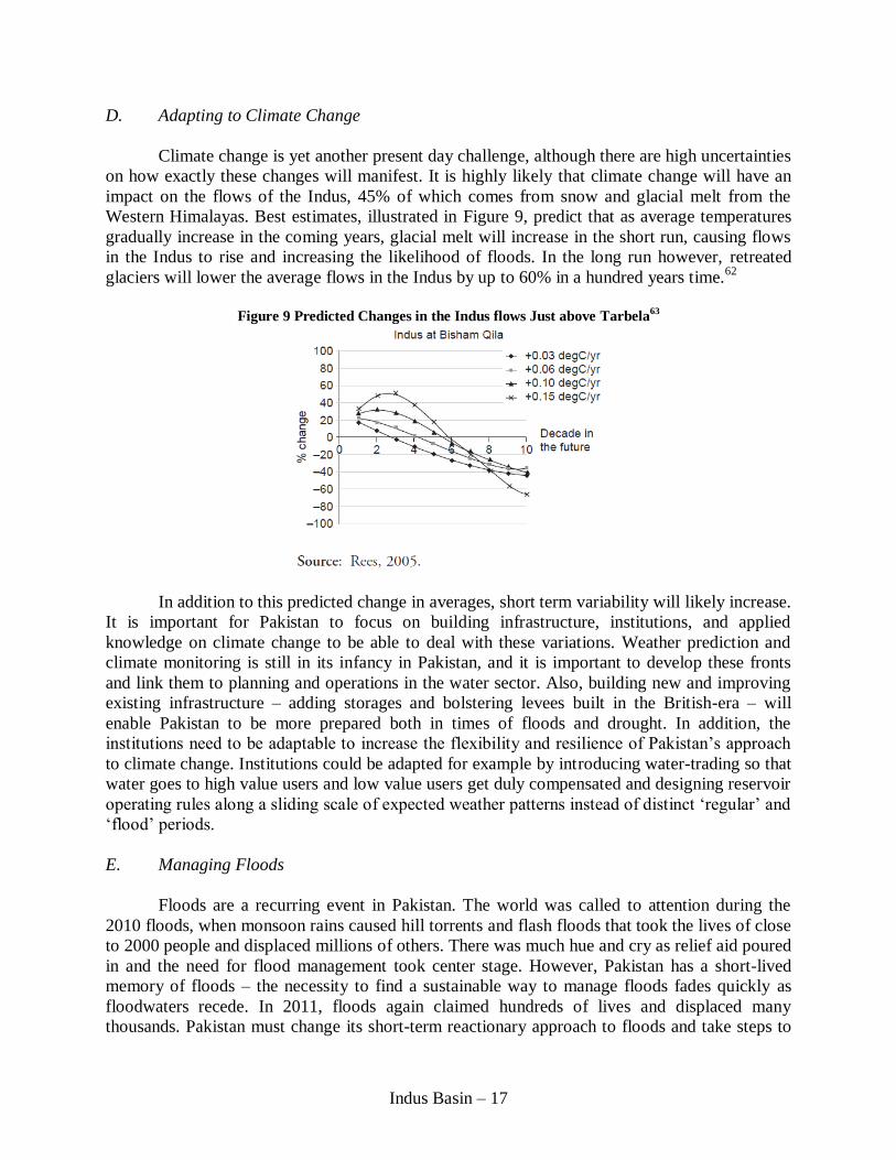
Climate change is yet another present day challenge, although there are high uncertainties
on how exactly these changes will manifest. It is highly likely that climate change will have an
impact on the flows of the Indus, 45% of which comes from snow and glacial melt from the
Western Himalayas. Best estimates, illustrated in Figure 9, predict that as average temperatures
gradually increase in the coming years, glacial melt will increase in the short run, causing flows
in the Indus to rise and increasing the likelihood of floods. In the long run however, retreated
glaciers will lower the average flows in the Indus by up to 60% in a hundred years time.62
Figure 9 Predicted Changes in the Indus flows Just above Tarbela
63
In addition to this predicted change in averages, short term variability will likely increase.
It is important for Pakistan to focus on building infrastructure, institutions, and applied
knowledge on climate change to be able to deal with these variations. Weather prediction and
climate monitoring is still in its infancy in Pakistan, and it is important to develop these fronts
and link them to planning and operations in the water sector. Also, building new and improving
existing infrastructure – adding storages and bolstering levees built in the British-era – will
enable Pakistan to be more prepared both in times of floods and drought. In addition, the
institutions need to be adaptable to increase the flexibility and resilience of Pakistan’s approach
to climate change. Institutions could be adapted for example by introducing water-trading so that
water goes to high value users and low value users get duly compensated and designing reservoir
operating rules along a sliding scale of expected weather patterns instead of distinct ‘regular’ and
‘flood’ periods.
E. Managing Floods
Floods are a recurring event in Pakistan. The world was called to attention during the
2010 floods, when monsoon rains caused hill torrents and flash floods that took the lives of close
to 2000 people and displaced millions of others. There was much hue and cry as relief aid poured
in and the need for flood management took center stage. However, Pakistan has a short-lived
memory of floods – the necessity to find a sustainable way to manage floods fades quickly as
floodwaters recede. In 2011, floods again claimed hundreds of lives and displaced many
thousands. Pakistan must change its short-term reactionary approach to floods and take steps to
Indus Basin – 18
strengthen its long-term flood security. This can be achieved by building the infrastructure,
institutions, and information systems in order to be able to anticipate floods and manage them in
a way that minimizes their damages when they inevitably do occur.
Pakistan’s two existing reservoirs, Tarbela and Mangla, played an important role in
absorbing flood peaks during the 2010 floods.64
Farrukh claims that having the capacity to store
merely 15% of the water drained to the sea during the 2010 floods would not only have reduced
flood damages, but would ensure irrigation supplies for the entire year and provide enough water
to meet downstream environmental needs. While building additional storages dam is central in
the strategy to combat floods, operation and maintenance of existing barrages and levees is
equally important. The majority of structural failures during the 2010 flood, culpable for much of
the human loss, occurred before water levels reached their designated capacity, thereby
suggesting weak design or a lack of proper operation and maintenance.65
The Indus River, with
its high silt load, has a natural tendency to meander as silt deposition raises the river bed and
causes the water to shift to adjacent lower ground. Since erecting levees to guide the course of
the river prevents the natural shift of the river, the levee structure must be sturdy enough to
withstand water pressure of the river. The immensity of this pressure during flood time, coupled
with century-old structures lacking proper maintenance, and increased settlement of people along
the banks of the river combinedly result in a very high flood risk.
Along with bolstered infrastructure, it is essential to make institutional improvements via
designating floodways, flood-time operating rules, and resettlement and compensation
mechanisms for those affected. Adopting flood forecasting techniques used in other flood-prone
regions of the world and installing adequate flood warning transmission systems will allow
preparation for an imminent event. The magnitude of flood risk depends upon two components:
probability of flood occurrence and impact of flood. There is little that can be done to reduce the
former, but the latter can be greatly reduced by improvements in infrastructure, institutions, and
information systems, thereby reducing overall flood risk.
F. Environmental Flows
The need for environmental flows in the Indus Basin was acknowledged for the first time
in 1991, during the writing of the Water Apportionment Accord. However, the provinces were
not able to agree on the amount necessary for the environment and at the time it was decided that
further studies would be undertaken to determine this number. 66
These studies have since been carried out by an international panel of experts which
states in its final report from 2005 that a perennial flow of 5,000 cubic feet per second is required
from Kotri Barrage to the sea to check seawater intrusion, sustain coastal fisheries, prevent
salinity accumulation in the Basin, and to maintain a sustainable environment in the delta.67
In
addition to perennial flow that is required at all times, the report also states a necessary
cumulative flow of 25 MAF in a 5 year period in order to meet the sediment demand of the coast.
The extensive canal network of the IBIS has diverted most of the river’s water for irrigation and
as a result reduced the sediment supply to the delta substantially. A concentrated high flow,
achieved during the Kharif monsoons, is therefore necessary to restore sediment equilibrium
amidst the now permanently altered flows. In a completely un-interfered environment, 400
Indus Basin – 19
million tons of sediment was supplied to the Indus delta every year, growing the coast by about
30 meters annually. A much smaller amount of sediment, that provided by high flows of 25 MAF
over 5 years, is deemed sufficient to maintain a stable coastline and also to sustain the
mangroves essential to the ecosystem of the delta.68
Establishing these numbers has not meant they are provided. The Accord recognizes that
environmental flows are needed, but neither allocates them separately, nor indicates which
province’s share the flows must come out of. Although IRSA includes water for the
environmental while calculating allocations for the provinces in each 10-day period,
environmental flows are the first to be compromised when there is insufficient supply in the
system. While Sindh, the southern-most province and home of the delta, is a strong proponent of
meeting environmental needs, the other three provinces claim that this requirement is fulfilled,
citing that upto 30 MAF flows down Kotri in certain years. However, this only holds true of
years when floods occur. Meanwhile perennial flows are largely ignored, as farmers at the mouth
of the river describe the trickle that flows into the sea during the late Rabi months.
With such a large part of its economy dependent on the river, the long-term cost of
ignoring environmental flows is too high for the Indus Basin to not consider. The fate of these
flows cannot be left to the handful of NGOs that advocate environmental flows; it must become
part of the national water strategy. As plans for constructing new storages, Basha for example,
advance, there is an opportunity to revisit the procedure of making allocations and recognizing
the environment as a rightful recipient. We must be cognizant, however, that this window of
opportunity is narrow, as provinces will claim increases in current allocations, and the federal
government must take a strong stance to prioritize environmental needs for the long-term benefit
of the overall Basin.
G. Infrastructure: Building New Storage
When the IBRW commenced, Tarbela and Mangla were envisioned to be only the
beginning of a vast array of storages on the Indus. Indeed in such an arid climate fed by highly
variable rivers, large dams are the only method to ensure year-round surface water supply for
irrigation. A 1968 report commissioned by The World Bank titled Water and Power Resources
of West Pakistan: A Study in Sector Planning, popularly known as the Lieftnick Report,
recognized agriculture to be the core of Pakistan’s long-term development plan. The report
flagged insufficient irrigation development as one of the major factors limiting growth of
agricultural production in the decade between 1950 and 1960. The report recommended Tarbela
as the centerpiece of the response, followed by a sequence of other dams on the Indus. In order to
meet increasing agricultural demands, the Lieftnick Report recommended that at least one
reservoir the size of Tarbela be constructed every ten years. The report detailed that every
additional million acre feet of storage available for agriculture would create an annual yield of a
million acre feet. As depicted in the storage yield curve shown in Figure 10, this meant that the
Indus still had significant storage potential remaining to be tapped. The urgency to build
additional storages was further amplified by the prediction that the storage capacities of the
existing dams would decrease over time due to the high silt load of the Indus, with its origins in
the young Himalayan mountains.

Indus Basin – 20
Figure 10 Storage Additional-Yield Curve for the Indus69
The Lieftinck Report put forward a second reason for the construction of additional
storages – Pakistan’s enormous untapped hydropower potential. The report predicted that a
quarter of Tarbela’s direct benefits would come from hydropower, which ex-post turned out to
be an under-estimate. The report calculated that the annual increase in electricity production
needed to be approximately13 percent for Pakistan’s growth targets to be met; hydropower
generated from large dams would be clean, cheap, and abundant if storages were built as per the
proposed schedule.70
IV. INSTITUTIONAL CHALLENGE OF THE PRESENT: 1991 WATER APPORTIONMENT ACCORD
The 1991 Water Apportionment Accord governs inter-provincial sharing of surface waters
and is at the root of federal-state interactions on water management in the Indus Basin. It is a
major achievement, the first of its kind in the South Asia region and still absent in neighboring
India, that came into being after a hurried meeting of the chief ministers of the Pakistan’s four
provinces in 1991. It was instituted with the main goal of formalizing water distribution
procedures to build trust among the provinces, critical to achieving consensus on building
additional storages and setting their operating rules. The Indus River System Authority (IRSA)
was set up to implement the Accord.
The success of such an accord can be measured by its stability and predictability as well as
its adaptability and flexibility to changing conditions over time. On these criteria, the case of the
Accord is one of ‘glass half full and glass half empty.’ In the two decades since it came into
being, the Accord has worked reasonably well in terms of providing a framework for distribut ing
canal water among the provinces. It protects the ‘historic uses’ of water from the post-Tarbela
period of 1977-82. However, the Accord is implemented with a priority for irrigation – the
Accord’s stated purpose at the time of its writing – at the cost of other potentially more valuable
functions such as hydropower generation and flood control. Indeed, this is in line with the
previously discussed hypothesis that legality has precedence over practicality in Pakistan. Most
importantly, the Accord is lacking in terms of building trust and in many ways the operational
opacity of the Accord has exacerbated historical animosities among the provinces. We present a
detailed investigation of these ambiguities, followed by subsequent opportunities to overcome
them and achieve operational efficiency in a way that strengthens, and not weakens, water
security of the Basin.
Indus Basin – 21
A. Key Ambiguity in the Accord: Definition of Initial Conditions
The key ambiguity in the Accord stems from the definition of ‘initial conditions,’ i.e. the
baseline conditions for the Accord to be applicable. The interpretation of this ambiguity has very
real effects as there is considerable variation in the size of allocation to each province depending
on the definition chosen. Punjab takes the view that the percentages of distribution laid out in
paragraph 2 of the Accord is contingent on the completion of additional storages leading up to a
total storage capacity of 114 MAF in the Basin (the capacity at the time of writing of the Accord
was 103 MAF, and has decreased since due to silting of existing reservoirs). Punjab claims that
paragraph 2 divides a total of 114 MAF and so the Accord cannot come into effect until that
capacity is reached; in the interim, Punjab states that water should be distributed as per the
percentages of historical use laid out in paragraph 14(b) of the Accord. On the other hand,
Sindh’s take on the initial conditions debate is that once the 10-daily distribution allotments were
worked out in the making of the Accord in 1991, the distribution of water was by default to be
done according to the percentages in paragraph 2.
B. Evolution of Interpretations of the Accord: 1991 to Present
For all the debate over the legality of different paragraphs of the Accord, it is interesting
that water allocation was done more or less on an ad hoc basis until 1999 despite the creation of
the Accord in 1991. The 1990s were a decade of ample water availability, therefore provinces
received their indents (water requirement expressed to IRSA) and there was no controversy over
water distribution. However, low water availability in the post-1999 period led to the
implementation of the decision of the 1994 ministerial meeting which called for allocation of
water according to historical uses of 1977-82; the argument was that in a period of low water
availability, historical uses must be preserved, and thus actual uses of the post-Tarbela period
should be honored over percentages stated in paragraph 2 of the Accord. This interpretation held
until 2001-02 when the Law Division declared it illegal and therefore void. Controversy on the
initial conditions debate did not stop however, and in 2003, at a time of extreme water deficit in
the Basin, IRSA devised a three-tier formula for water allocation, which continues to be
implemented till date.
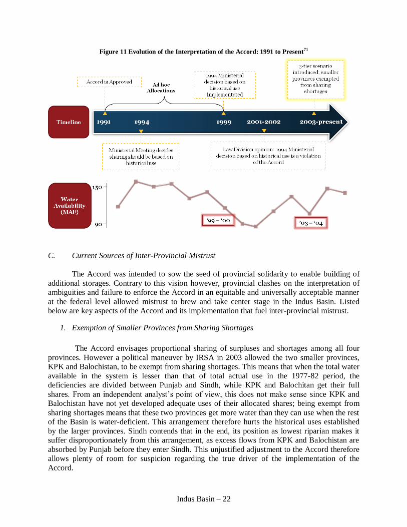
The interesting point to note here is that new interpretations of the Accord surfaced
whenever water availability in the system was low. When a new interpretation surfaced, a strong
emphasis was placed on legality; in the end however the ruling interpretation turned out to be
politically, and not technically, motivated. Error! Reference source not found.Figure 11
summarizes the evolution of the Accord, juxtaposing it with water availability in the system.
Indus Basin – 22
Figure 11 Evolution of the Interpretation of the Accord: 1991 to Present71
C. Current Sources of Inter-Provincial Mistrust
The Accord was intended to sow the seed of provincial solidarity to enable building of
additional storages. Contrary to this vision however, provincial clashes on the interpretation of
ambiguities and failure to enforce the Accord in an equitable and universally acceptable manner
at the federal level allowed mistrust to brew and take center stage in the Indus Basin. Listed
below are key aspects of the Accord and its implementation that fuel inter-provincial mistrust.
1. Exemption of Smaller Provinces from Sharing Shortages
The Accord envisages proportional sharing of surpluses and shortages among all four
provinces. However a political maneuver by IRSA in 2003 allowed the two smaller provinces,
KPK and Balochistan, to be exempt from sharing shortages. This means that when the total water
available in the system is lesser than that of total actual use in the 1977-82 period, the
deficiencies are divided between Punjab and Sindh, while KPK and Balochitan get their full
shares. From an independent analyst’s point of view, this does not make sense since KPK and
Balochistan have not yet developed adequate uses of their allocated shares; being exempt from
sharing shortages means that these two provinces get more water than they can use when the rest
of the Basin is water-deficient. This arrangement therefore hurts the historical uses established
by the larger provinces. Sindh contends that in the end, its position as lowest riparian makes it
suffer disproportionately from this arrangement, as excess flows from KPK and Balochistan are
absorbed by Punjab before they enter Sindh. This unjustified adjustment to the Accord therefore
allows plenty of room for suspicion regarding the true driver of the implementation of the
Accord.

Indus Basin – 23
2. Three-Tier Method of Water Allocation
IRSA currently uses the three-tier method to distribute water among provinces. This
method consists of three different proportions of division depending on how much total water is
predicted to be available in the system in an upcoming year.
In the low-availability scenario, where the total water available is less than the average
availability in the 1977–82 period, water is distributed as per paragraph 14(b) of the Accord. The
source of the controversy in using this proportion is that it gives more water to Punjab since
Punjab’s agricultural network was the most extensively developed during the period and
therefore its established historical uses are the largest. By default then, Punjab is comparatively
better off during times of drought, when water is most desirable to all provinces.
In the medium-availability scenario, where the total water available is more than the
average availability in the 1977–82 period but less than that defined in paragraph 2 of the Accord
(114 MAF), historic uses are protected as laid out in paragraph 14(b) for the distribution of up to
103 MAF, with the balance distributed as per paragraph 2. Sindh is better off in this scenario
than in the low availability scenario; however, two factors – that this scenario is less common,
and that the marginal value of water is not as high as in the low availability scenario – result in
Sindh remaining disgruntled.
In the high-availability scenario, where the total water available is greater than that
defined in paragraph 2 of the Accord, the allocations totaling 114 MAF are to be made as per
paragraph 2 while any water in excess is to be distributed as per paragraph 4. This scenario is
rare and given that storage is in severe shortage in the Basin, exists only during flood times when
provinces are not competing for water.
Sindh argues that the Accord does not envisage such a three-tier methodology at all and
that the very use of this formula is baseless. Further, the 2003 meeting minutes of IRSA’s
Advisory Committee state that the three-tier was devised to be used only for a year in 2003.
However, it continues to be implemented to date and is now established as a functioning,
although uneasy, modus operandi with constant contesting, especially from Sindh, regarding its
validity.
3. Failure to Appeal to the Council of Common Interests
Articles 153-155 of the constitution of Pakistan give the provinces access to the federal
government through the Council of Common Interests (CCI) to appeal any water-related
decisions of IRSA. The CCI is a political body comprised of the chief ministers of the provinces
and headed by the prime minister. The constitution further details that if a province is dissatisfied
with the CCI’s decision on any matter, it may take the issue to a joint-sitting of the parliament.
Despite provinces constantly voicing dissatisfactions regarding perceived ‘unfairness’, no party
has yet taken IRSA’s decisions to the CCI. While this allows the province that appears to be
benefitting from the concerned arrangement to maintain that the misgivings are baseless
Indus Basin – 24
lamentations that have no legal backing, it speaks for a lack of confidence in the judicial system
and the perceived risk of coming out ‘worse off’ as a result of an appeal.
4. Indus River System Authority
There are several technical and institutional issues related to IRSA’s implementation of
the Accord that prevent building trust among the provinces, as originally envisaged by the
Accord.
a) Technical Issues
i. Water Availability Prediction: Provincial Politicization of Technical Task
As per the three-tier method, IRSA determines the proportions of water allocation
among provinces based on the total amount predicted to be in the system in a given year.
Needless to say, determining this predicted amount is one of the most important decisions IRSA
has to make. The process of arriving at the predicted amount, a purely technical task which, in
truth, should be removed from all political considerations, is highly politicized in Pakistan. There
are two major weaknesses in the methodology that IRSA uses to predict water availability: one is
the accuracy of the method adopted and the other is the conflict of interest among the parties
providing input towards the decision.
The method of predicting water availability is a rudimentary one in which predictions
are supplied by each of IRSA, WAPDA, and the provinces, which are then averaged to come to a
final prediction. Each party that provides input comes to its own number by taking the actual
amount of water available in the previous Rabi season, picking out specific years from historical
records that had similar precipitation in the Rabi season, then averaging the precipitations from
the corresponding Kharif seasons and extrapolating to get the prediction for the upcoming
Kharif. Not only does this method fail to take into account any weather prediction or climate
change patterns, it completely ignores the increasing variability that is to be expected with
climate change. This process of prediction is surrounded by a high degree of anticipation and
strong media coverage, but the accuracy of the process itself is overlooked.
The second concern is that of the conflict of interest among the parties that provide input
to the decision. IRSA’s Technical Committee takes into consideration the prediction of each
province. However, as described earlier, the distribution proportions depend upon the total
predicted availability, with different provinces gaining or losing under different scenarios; each
province therefore has a different interest in the predicted water availability that is likely to sway
its individual prediction. This flawed process naturally undermines trust in IRSA as a neutral
predictor, arbiter, and deliverer of water to the provinces.
ii. Flow Monitoring: Federal Mandate Reliant on Provincial Cooperation
IRSA’s mandate to allocate water among provinces necessitates that it monitor water
withdrawal at different canal heads and barrages in order to ensure that provinces are in
compliance of their withdrawal amounts. However, IRSA officials do not have the capability or
Indus Basin – 25
authority to conduct this monitoring. Since barrages where canal heads are situated are owned by
the provinces, officials from IRSA, a federal agency, are barred by provincial engineers from
placing their gauges and obtaining data. Under the current arrangement, provinces self-report
their water withdrawal amounts. IRSA officials lack the authority to verify the data that they
receive from the provinces. IRSA is not authorized to take any punitive action towards provinces
that refuse cooperation.
In 2002-03, WAPDA and IRSA attempted to install a telemetry system along the length
of the irrigation network to obtain independent automated water level readings; however this
system was never made fully functional and in fact caused further inter-agency conflict. The
resulting lack of transparency allows provinces to withdraw more than their allocated share,
meaning that less water is available for the lower riparian province. In cases where a lower
riparian province is withdrawing more than its share, the absence of monitoring by a central
agency like IRSA allows this lower riparian province to continue acting as a victim and pretend
it is getting less than its share. The inability to perform a water audit creates the space for all
provinces to blame others for illegally abstracting more than their fair share.
The ministerial meeting that instituted IRSA gave it the mandate to allocate water among
the states, yet it did not give IRSA the authority to fully execute this mandate. Assuming that all
provinces would support transparent data sharing was a major negligence of the political
economy of the basin while IRSA was being created. There are current efforts underway to
revive a few of the existing telemetric monitoring stations but a more long-term solution has to
be found by initiating a comprehensive monitoring process that has the trust and buy-in of the
agencies at both the federal and provincial level.
iii. Increasing Conveyance Losses
Over the last decade, reported ‘conveyance losses’ between barrages have grown to an
estimated 20 MAF. There is however no effective measurement of these ‘conveyance losses’ and
it is perceived that they are in fact ‘unauthorized abstractions’ by influential politicians and large
landlords. Buttressing this perception is the fact that there is no knowledge of any changes in
river morphology or canal conditions that could account for such increasing figures.
There is an urgent need for a sound technical assessment of these ‘losses.’ Punjab has
taken a positive step in this regard by putting its 2007 canal-head entitlements and deliveries
online.72
This needs to emulated by the other provinces to increase transparency in the system.
b) Institutional Issues
IRSA’s ability to manage the Accord and mitigate inter-provincial mistrust is hampered
by critical institutional issues.
i. Weak Enforcement Authority
The Accord as it exists is an incomplete contract. IRSA is not authorized to verify
withdrawal numbers reported by provinces, which results in part from the fact that irrigation is a

Indus Basin – 26
provincial subject under the constitution and hence barrages and canal infrastructure are under
provincial management. IRSA is not authorized to take any punitive action towards provinces
not in compliance of withdrawing allocated amounts. Thus should a province self-report excess
withdrawal amounts, they are not subject to consequences such as fines or reduction in water
allocations in the future. This complete lack of punitive action makes unauthorized over-
withdrawal of water a viable option whenever necessary, thereby de-legitimizing the very
existence of IRSA.
ii. Lack of Funding and Subsequent Loss of Autonomy
At its inception, IRSA was envisaged to be corporatized but this step was never taken;
IRSA is still operating under the Ministry of Water and Power and relies on it for its budget. This
has compromised IRSA’s overall autonomy. The funds IRSA receives from the federal
government are neither sufficient nor disbursed in a timely manner to defray operating costs such
as employee salaries and benefits. Consequently, IRSA members often have to rely on their
provinces to provide them with benefits such as housing and transport at the IRSA offices in
Islamabad. As a result of this provincial dependence, IRSA members often consult with their
provinces before making decisions regarding water allocations. Hence decisions that are
inherently technical become politicized, thereby increasing mistrust around IRSA and inter-
provincial water allocations. Furthermore, underfunding means that IRSA is compelled to sell
its data to obtain funds. This lack of freely available data does not help the already present
obscurity.
Important steps have recently been taken to secure reliable sources of funding for IRSA.
These sources include first, a portion of the revenue from hydropower generation (Rs 140
million annually) from the electricity authority, and second, a payment from the provinces per
acre feet water used for irrigation (Rs 20 million annually). These steps are designed to increase
annual revenue from the present Rs 26.5 million to Rs 190 million.73
Although this appears to be
a significant increase and the federal government is pressurizing IRSA to form a clear vision to
properly utilize these funds, it again fails to take into account the political economy amidst which
these funds are to be obtained. Some parties benefit (in the short run, at least) from the lack of
water accounting, which might explain why provinces have yet to make their payments despite
this new regulation being instituted over a year ago. Again, no punitive measures are specified
for non-compliance in payments leading one to guess that this could be yet another change
confined to paper.
iii. Absence of an Overarching Regulatory Framework in the Water Sector
This overview of Pakistan’s water sector clearly shows that there is no one agency or
regulatory framework at the federal level responsible for overall planning and development of
the water sector in Pakistan. The recently enacted 18th Amendment to the Constitution has
further devolved federal responsibilities to the provinces and it is not clear how the provinces
will coordinate in carrying out various functions – after all, the hydrologic system knows no
political boundaries, and externalities from one province are bound to affect other provinces in
the Basin. For example, the Ministry for the Environment at the federal level has been
dismantled in order to grant provinces autonomy in carrying out activities related to the
Indus Basin – 27
environment, and it is unclear who will now be responsible for the institutionalization of much
needed environmental flows in the Basin.
Lack of an inter-ministerial and inter-provincial coordinating body that facilitates
sharing of ideas across departmental boundaries is seen as a serious deficiency in Pakistan’s
water sector. The creation of such a coordinating agency might be seen to increase transaction
costs; however if planned out carefully, it has the potential for mobilizing resources needed to
handle challenges of the 21st century.
D. Possible Next Steps: Increasing Transparency to Reduce Mistrust
In the short and medium term, Pakistan’s water agencies could take several key steps to
increase operational transparency and bolster the institutional framework in the water sector.
These incremental and complementary steps will increase the likelihood of Pakistan’s water
sector moving towards more trust among provinces, improved coordination, greater efficiency,
all to realize more fully its growth potential and contribution to national development.
1. Improve Water Availability Predictions
The country’s federal water agencies IRSA and WAPDA along with provincial
irrigation departments need to coordinate to put in place an independent, reliable, and modern
water prediction methodology. In this regard, it may be appropriate to consult with other large
multi-state basins around the world and adapt the most suited technology to the Indus Basin as
well as invest in enhancing existing indigenous capacity.
2. Establish Independent Monitoring
As water availability prediction systems are enhanced, a concerted federal and
provincial process needs to be put in place that leads to a reliable method of flow monitoring and
a through audit of conveyance losses. Increased transparency may subsequently ask that
provinces in which conveyance losses have increased must compensate those that have suffered
as a result of such losses. Therefore an appropriate compensatory mechanism must be put into
place. However, if it is more expedient to leave past irregular behavior aside to focus on forward
auditing, then that must be chosen with the goal of gaining universal approval and installing a
monitoring system that is independent, trustworthy, and technically robust.
3. Formalize Water Trading
A first step towards formalizing the trading of water towards higher-value uses can be
the compensated transfer of water between provinces. IRSA’s functional decision to exempt
KPK and Balochistan from sharing of shortages, in effect, means that the ‘unused’ portions of
their allocations are utilized by the larger provinces, mainly Punjab. The smaller provinces are
increasingly advocating for compensation from the larger provinces for taking up their unused
shares of water; a formal compensation would signify that the larger provinces recognize they
are using another province’s share. Therefore in a future assessment of water allocations, a large
province would not be able to claim that amount simply based on ‘established use’ but will have

Indus Basin – 28
to make some sort of payment for a permanent transfer of entitlement. While these requests are
being resisted for the time being it is likely that with time they will continue to grow and the
resulting pressure will prompt some action. The de facto operating of the Accord in fact is a
golden opportunity for IRSA to develop an inter-provincial water trading mechanism that sets
the stage for water trading to begin at the more micro-level trading between farmers and across
sectors towards higher-value users.
4. Modernize Sharing of Hydropower Royalties
Article 161(2) of the constitution of Pakistan provides that, “The net profits earned by
the Federal Government or any undertaking established or administered by the Federal
Government for the bulk generation of power at a hydro electric station shall be paid to the
province in which the hydro electric station is situated.” This clause of the constitution has
hindered the construction of new dams for the purposes of hydropower generation, particularly
as provinces have a huge incentive to situate the power plant turbine in their territory so that they
can be the main beneficiary. Not all locations are geographically suited for the placement of a
dam’s power plant; Sindh in particular with its flat lands cannot house a reservoir and therefore,
under the present benefit-sharing formula, cannot benefit from hydropower profits. This setup,
where at least one party faces risks but inherently cannot receive any benefits, causes endless
wrangling that delays the setup of a much needed power plant and also induces a negative spiral
of behavior – ‘if we cannot benefit, neither will we let anyone else.’ While at the national level,
lower-cost electricity particularly in the form of clean hydropower would benefit every citizen,
the exigencies of politics and the constitutional benefit-sharing formula do not enable additional
storages to be constructed.
Pakistan can look towards other federal countries that have developed better benefit-
sharing mechanisms in order to modernize its own. In particular, there is a growing consensus
that communities that pay the direct costs, e.g. facing resettlement, should be the primary
beneficiaries. In Brazil for example, 3 percent of hydropower revenue goes to affected provinces
and a further 3 percent goes to affected municipalities.74
This method of directly compensating
those that face the brunt of the project, while also sharing with other stakeholders in proportion
to the risk that they face, will likely enable Pakistan to gather the political buy-in necessary to
build its much needed storages.
V. CONCLUSION
This discussion of the ambiguities in the Accord and the lack of transparency in the
Accord’s implementation showcases how provinces have reached a stalemate amidst a complex
modus operandi. The formal path out of this uneasy equilibrium, via appealing to the Council of
Common Interests, has not yet been sought, as it appears that no one province can take the risk of
unraveling the system. The discussion of shifting interpretations of the Accord ambiguities also
highlights the irony of how legality is undermined in the most legally conscious of societies.
Here, the pursuit of a legal solution itself is questionable, since the challenges at hand have
technical solutions proven to be successful in other federal river basins of the world and the legal
path appears to simply add extra time and rigidity. The true challenge in the Indus Basin then,
Indus Basin – 29
appears to be raising the water sector as a national priority that is higher than the deepening
provincial factionalism.
One only needs to glance at historical accounts to see the wonders of the Indus Basin –
indeed this is a basin that transformed from a desert to prolific bread basket, that lost half its
rivers and yet continued to thrive, that rescued entire fields from the grasp of salinity, and that
has the resilience to withstand, time and again, the most calamitous of natural phenomena. The
past has shown how the people of the Indus are pioneers in engineering projects massive enough
to change the hydraulics of the entire basin. Perhaps it is from history that the Basin today can
draw inspiration, to remember that the Basin does not adhere to political boundaries and that
coordination and cohesive action is at the core of today’s required responses. It must be
remembered that any one province cannot truly be better off in the long run by pursuing its
individual needs in the present at the cost of the health and well being of the basin. Looming
large are also transboundary challenges – issues on the IWT with India and potential concerns
with Afghanistan regarding the Kabul River – for which in-house unity is an absolute pre-
requisite if national water interests are to be secured. There is much to be done in the Indus
Basin, but of course, the past shows the resolve and capability that this Basin is made of; re-
building national solidarity in the water sector, built upon the foundations of transparency and
resulting inter-provincial trust, is the primary challenge of the 21st century.

Indus Basin – 30
1 Earth Changes and the Pole Shift, Pakistan Sinking: 8 Million Affected by Floods in Pakistan 9, (2011), available
at http://poleshift.ning.com/profiles/blogs/floods-of-2011. 2 David Gilmartin, Scientific Empire and Imperial Science: Colonialism and Irrigation Technology in the Indus
Basin, 53 J. ASIAN STUD. 1127, 1129 (1994). 3 ALOYS A. MICHEL, THE INDUS RIVERS: A STUDY OF THE EFFECTS OF PARTITION 49 (1967). 4 ALOYS A. MICHEL, THE INDUS RIVERS: A STUDY OF THE EFFECTS OF PARTITION 58 (1967). 5 IMRAN ALI, COUNTRY WATER RESOURCES ASSISTANCE STRATEGY BACKGROUND PAPER 9 – POLITICAL ECONOMY
OF WATER REFORMS IN PAKISTAN 4 (2005). 6 JOHN BRISCOE, USMAN QAMAR, PAKISTAN’S WATER ECONOMY: RUNNING DRY 17 (2007). 7 ALOYS A. MICHEL, THE INDUS RIVERS: A STUDY OF THE EFFECTS OF PARTITION 65 (1967). 8 D. J. BANDAROGODA, SAEED UR REHMAN, WARABANDI IN PAKISTAN’S CANAL IRRIGATION SYSTEMS: WIDENING
GAP BETWEEN THEORY AND PRACTICE 2 (1995), available at http://pdf.usaid.gov/pdf_docs/PNABY457.pdf 9 SARDAR MUHAMMAD TARIQ, INDUS WATERS TREATY AND EMERGING WATER MANAGEMENT ISSUES OF PAKISTAN
88 (2007). 10
PERVAIZ AMIR, COUNTRY WATER RESOURCES ASSISTANCE STRATEGY BACKGROUND PAPER 10 – THE ROLE OF
LARGE DAMS IN THE INDUS BASIN 3 (2005). 11 JOHN BRISCOE, USMAN QAMAR, PAKISTAN’S WATER ECONOMY: RUNNING DRY 13 (2007). 12
A. S. Qureshi, P. G. Mccornick, M. Qadir, Z. Aslam, Managing Salinity and Waterlogging in the Indus Basin of
Pakistan, 95 AGRIC. WATER MGM’T 1, 3 (2008). 13 JOHN BRISCOE, USMAN QAMAR, PAKISTAN’S WATER ECONOMY: RUNNING DRY 13 (2007). 14
Shahid Amjad Chaudhry, Pakistan: Indus Basin Water Strategy – Past, Present, and Future, 15 LAHORE J. ECON.
187, 190 (2010). 15
PAKISTAN BUREAU OF STATISTICS, DOCUMENT NAME? , PG # (2009-2010). 16
PAKISTAN BUREAU OF STATISTICS, DOCUMENT NAME? , PG # (2009-2010). 17
FRANK VAN STEENBERGEN, M. SHAMSHAD GOHAR, COUNTRY WATER RESOURCES ASSISTANCE STRATEGY
BACKGROUND PAPER 11 – GROUNDWATER DEVELOPMENT AND MANAGEMENT IN PAKISTAN 3 (2005). 18
JOHN BRISCOE, USMAN QAMAR, PAKISTAN’S WATER ECONOMY: RUNNING DRY 42 (2007). 19 aquastat, FAO’S INFORMATION SYSTEM ON WATER AND AGRICULTURE,
http://readperiodicals.com/201009/2173656211.html#b (last visited Aug. 16 2012). 20 SHAHID AHMAD, WATER BALANCE AND EVAPO-TRANSPIRATION, 6 (2005). 21 Pakistan Ministry of Water and Power, National Water Sector Profile, 5 NAT’L WATER SECTOR STRATEGY
(2002). 22 Pakistan Ministry of Water and Power, National Water Sector Profile, 5 NAT’L WATER SECTOR STRATEGY
(2002). 23 Pakistan Ministry of Water and Power, National Water Sector Profile, 5 NAT’L WATER SECTOR STRATEGY
(2002). 24 Pakistan Ministry of Water and Power, National Water Sector Profile, 5 NAT’L WATER SECTOR STRATEGY
(2002). 25 PERVAIZ AMIR, COUNTRY WATER RESOURCES ASSISTANCE STRATEGY BACKGROUND PAPER 12 – AGRICULTURAL
MODERNIZATION THROUGH BETTER WATER MANAGEMENT 1 (2005). 26 Pakistan Land Tenure and Property Rights, UNITED STATES AGENCY FOR INTERNATIONAL DEVELOPMENT,
http://www.usaidlandtenure.net/country-profiles/pakistan (Sept. 2011). 27 Source? 28 GOVERNMENT OF PAKISTAN, HANDBOOK ON WATER STATISTICS ON PAKISTAN, PG # (2005). 29 M. Kaleem Ullah, Z Habib, S Muhammad, Spatial Distribution of Reference and Potential Evapotranspiration
Across The Indus Basin Irrigation Systems PG# (2001) (Working Paper 24) (on file with IWMI) 30 PAKISTAN BUREAU OF STATISTICS, DOCUMENT NAME? , PG # (2009-2010). 31 aquastat, FAO’S INFORMATION SYSTEM ON WATER AND AGRICULTURE,
http://readperiodicals.com/201009/2173656211.html#b (last visited Aug. 16 2012). 32 D. PONTIUS, COLORADO RIVER BASIN STUDY: A REPORT TO THE WESTERN WATER POLICY REVIEW ADVISORY
COMMISSION PG# (1997). 33 Source?

Indus Basin – 31
34 DON BLACKMORE, FAIZUL HASAN, COUNTRY WATER RESOURCES ASSISTANCE STRATEGY BACKGROUND PAPER 6
– WATER RIGHTS AND ENTITLEMENTS PG# (2005). 35 DON BLACKMORE, FAIZUL HASAN, COUNTRY WATER RESOURCES ASSISTANCE STRATEGY BACKGROUND PAPER 6
– WATER RIGHTS AND ENTITLEMENTS PG# (2005). 36 SHAHID AHMAD, COUNTRY WATER RESOURCES ASSISTANCE STRATEGY BACKGROUND PAPER 5 – WATER
BALANCE AND EVAPO-TRANSPIRATION PG# (2005). 37 PAKISTAN BUREAU OF STATISTICS, DOCUMENT NAME? , PG # (2009-2010). 38 SHAHID AHMAD, COUNTRY WATER RESOURCES ASSISTANCE STRATEGY BACKGROUND PAPER 5 – WATER
BALANCE AND EVAPO-TRANSPIRATION PG# (2005). 39 Pakistan Ministry of Water and Power, National Water Sector Profile, 5 NAT’L WATER SECTOR STRATEGY
(2002). 40 JOHN BRISCOE, USMAN QAMAR, PAKISTAN’S WATER ECONOMY: RUNNING DRY 5 (2007). 41 CHRIS TRIMBLE, NOBUO YOSHIDA, MOHAMMAD SAQIB, RETHINKING ELECTRICITY TARIFFS AND SUBSIDIES IN
PAKISTAN – WORLD BANK REPORT 62971-PK PG# (2001). 42 CHRIS TRIMBLE, NOBUO YOSHIDA, MOHAMMAD SAQIB, RETHINKING ELECTRICITY TARIFFS AND SUBSIDIES IN
PAKISTAN – WORLD BANK REPORT 62971-PK PG# (2001). 43 CHRIS TRIMBLE, NOBUO YOSHIDA, MOHAMMAD SAQIB, RETHINKING ELECTRICITY TARIFFS AND SUBSIDIES IN
PAKISTAN – WORLD BANK REPORT 62971-PK PG# (2001). 44 CHRIS TRIMBLE, NOBUO YOSHIDA, MOHAMMAD SAQIB, RETHINKING ELECTRICITY TARIFFS AND SUBSIDIES IN
PAKISTAN – WORLD BANK REPORT 62971-PK PG# (2001). 45 CHRIS TRIMBLE, NOBUO YOSHIDA, MOHAMMAD SAQIB, RETHINKING ELECTRICITY TARIFFS AND SUBSIDIES IN
PAKISTAN – WORLD BANK REPORT 62971-PK PG# (2001). 46 ASIF H. KAZI, COUNTRY WATER RESOURCES ASSISTANCE STRATEGY BACKGROUND PAPER 14 – FLOOD CONTROL
AND MANAGEMENT PG# (2005). 47 Daanish Mustafa, David Wrathall, The Indus Basin Floods of 2010: The Cost of Agricultural Development?, 2 ON
THE WATER FRONT PG# (2010), available at www.worldwaterweek.org/onthewaterfront 2010 48 JOHN BRISCOE, USMAN QAMAR, PAKISTAN’S WATER ECONOMY: RUNNYING DRY 58 (2007). 49
INTERGOVERNMENTAL PANEL ON CLIMATE CHANGE, FOURTH ASSESSMENT REPORT: CLIMATE CHANGE (AR4)
(2007). 50 JOHN BRISCOE, USMAN QAMAR, PAKISTAN’S WATER ECONOMY: RUNNING DRY PG# (2007). 51 H. REHMAN, A. KAMAL, INDUS BASIN RIVER SYSTEM – FLOODING AND FLOOD MITIGATION PG# (2002). 52 Pakistan Ministry of Water and Power, National Water Sector Profile, 5 NAT’L WATER SECTOR STRATEGY
(2002). 53 Salman M. A. Salman, The Baglihar Difference and its Resolution Process – A Triumph for the Indus Waters
Treaty?, 10 WATER POLICY 105, 115 (2008). 54 Salman M. A. Salman, The Baglihar Difference and its Resolution Process – A Triumph for the Indus Waters
Treaty?, 10 WATER POLICY 105, 107 (2008). 55 Salman M. A. Salman, The Baglihar Difference and its Resolution Process – A Triumph for the Indus Waters
Treaty?, 10 WATER POLICY 105, 115 (2008). 56FRANK VAN STEENBERGEN, M. SHAMSHAD GOHAR, COUNTRY WATER RESOURCES ASSISTANCE STRATEGY
BACKGROUND PAPER 11 – GROUNDWATER DEVELOPMENT AND MANAGEMENT IN PAKISTAN 2 (2005). 57 JOHN BRISCOE, USMAN QAMAR, PAKISTAN’S WATER ECONOMY: RUNNING DRY 45 (2007). 58 PIETER LIEFTINCK, A. ROVERT SADOVE, THOMAS C. CREYKE ET AL., WATER AND POWER RESOURCES OF WEST
PAKISTAN: A STUDY IN SECTOR PLANNING VOLUME I 269 (1968). 59 JOHN BRISCOE, USMAN QAMAR, PAKISTAN’S WATER ECONOMY: RUNNING DRY 32 (2007). 60 JOHN BRISCOE, USMAN QAMAR, PAKISTAN’S WATER ECONOMY: RUNNING DRY 34 (2007). 61 Interview with Arif Nadeem, Punjab Secretary for Agriculture, in Lahore (June, 2011). 62 JOHN BRISCOE, USMAN QAMAR, PAKISTAN’S WATER ECONOMY: RUNNING DRY xvii (2007). 63 JOHN BRISCOE, USMAN QAMAR, PAKISTAN’S WATER ECONOMY: RUNNING DRY xvii (2007). 64
RAZA M. FARRUKH, PAKISTAN FLOOD 2010 8 (2010). 65 RAZA M. FARRUKH, PAKISTAN FLOOD 2010 9 (2010). 66 PAKISTAN WATER APPORTIONMENT ACCORD CLAUSE 7 (1991). 67 FERNANDO J. GONZALEZ, THINUS BASSON, BART SCHULTZ, FINAL REPORT OF IPOE FOR REVIEW OF STUDIES ON
WATER EXCAPAGES BELOW KOTRI BARRAGE I (2005).

Indus Basin – 32
68 FERNANDO J. GONZALEZ, THINUS BASSON, BART SCHULTZ, FINAL REPORT OF IPOE FOR REVIEW OF STUDIES ON
WATER EXCAPAGES BELOW KOTRI BARRAGE II (2005). 69 JOHN BRISCOE, USMAN QAMAR, PAKISTAN’S WATER ECONOMY: RUNNING DRY 65 (2007). 70 PIETER LIEFTINCK, A. ROVERT SADOVE, THOMAS C. CREYKE ET AL., WATER AND POWER RESOURCES OF WEST
PAKISTAN: A STUDY IN SECTOR PLANNING VOLUME I 223 (1968). 71 LAILA KASURI, ANJALI LOHANI, ERUM SATTAR, MUHAMMAD YOUSUF, PAKISTAN TRIP REPORT 17 (2011). 72 Water Entitlements, PUNJAB IRRIGATION & POWER DEPARTMENT ,http://irrigation.punjab.gov.pk/Entitlement.aspx
(last visited Aug. 27 2011). 73 Interview with IRSA Member KPK, in Islamabad, Pakistan (Dec. 2011). 74 Source?