The Indiana Floodplain Mapping Initiative - ASFPM Indiana Floodplain Mapping Initiative is a...
24
The Indiana Floodplain Mapping Initiative Prepared by the Indiana Department of Natural Resources Division of Water March 2004
Transcript of The Indiana Floodplain Mapping Initiative - ASFPM Indiana Floodplain Mapping Initiative is a...
The Indiana Floodplain Mapping Initiative
Prepared by the Indiana Department of Natural Resources Division of Water March 2004
Indiana Floodplain Mapping Initiative Page 2 of 24 March 2004 (b)
Credits
Preparation of this plan was funded through a CAP MAP grant through the Federal Emergency Management Agency in 2003. This report was prepared under the direction of Michael W. Neyer, PE, Director of the Division of Water and Kenneth E. Smith, PE and George C. Bowman, PE Assistant Directors, Division of Water. David B. Knipe, PE, CFM, is the main author of this report. The following Division staff members also contributed to this report: Debra J. Smith, Section Manager, Floodplain Management Section Gregory A. Main, CFM, NFIP State Coordinator, Floodplain Management Section Suzanne R. Delay, PE, Engineering Section Manager, South Basin Team, Engineering Services Center Rajindra Gosine, PE, LPG, Engineering Section Manager, North Basin Team, Engineering Services Center
Questions regarding this report can be addressed to: David B. Knipe, PE, CFM Engineering Section Manager, Central Basin Team Indiana Department of Natural Resources Division of Water 402 W. Washington St., Rm W264 Indianapolis, IN 46204 Ph: (317) 232 - 4160 (877) 928 - 3755 toll free Fax: (317) 233 - 4579 E: [email protected]
Indiana Floodplain Mapping Initiative Page 3 of 24 March 2004 (b)
Executive Summary
The Indiana Floodplain Mapping Initiative is a conceptual proposal by the Indiana Department of Natural Resources, Division of Water, to assume certain responsibilities for FEMA�s Map Modernization program in Indiana. The proposal is for the Engineering Services Center and the Floodplain Management Section of the Division to take a more active role in the digital conversion of existing floodplain mapping, to manage the creation of new detailed and approximate floodplain studies, to become the review authority for FEMA in the Letter of Map Revision process, and to be the lead agency on outreach and management of the overall Map Modernization effort in Indiana. This initiative is in response to FEMA�s plans for Map Modernization, which is scheduled for funding at least through federal Fiscal Year 2009. This report also includes funding requirements and a schedule of work for the creation of county-wide Digital Flood Insurance Rate Maps.
Introduction
The Federal Emergency Management Agency (FEMA), a part of the Department of Homeland Security, is the federal agency responsible for the administration of the National Flood Insurance Program (NFIP) and for the publication of Flood Insurance Rate Maps (FIRM�s). As the NFIP has evolved over the last 30 years, modernization and updating of the FIRM�s has lagged behind, resulting in a great many maps being out of date and based on technology that is obsolete. To remedy this situation, Congress has appropriated a sum of money towards a plan of FEMA�s known as Map Modernization.
The Indiana Department of Natural Resources, through the Division of Water, is the state coordinating agency for the NFIP and has always worked closely with FEMA on both NFIP and floodplain mapping issues. In 2003, FEMA invited and funded interested states to assemble proposals for the states to take over certain portions of the Map Modernization projects that might be in their interest. Since the Division of Water already has the staff capability to produce high quality floodplain mapping, and certain state initiatives are aligned with FEMA�s Map Modernization initiatives, this report is the Division�s plan for modernizing floodplain mapping for both FEMA and state purposes. This plan articulates the Division�s vision for digitally converting existing maps, for creating detailed and approximate studies of floodplains, for managing the Letter of Map Revision (LOMR) process, and for conducting meetings and other outreach activities to the various stakeholders with interests in modernized floodplain mapping. This initial plan is a conceptual plan, and details regarding the actual processes and implementation of these concepts will follow in future documents, contingent on FEMA�s approval.
Indiana Floodplain Mapping Initiative Page 4 of 24 March 2004 (b)
About the Division of Water
The Indiana Department of Conservation and the Indiana Flood Control and Water Resources Commission merged in 1965 to create the Indiana Department of Natural Resources (DNR). Divisions were subsequently formed within the DNR to address specialized natural resource concerns. Water resource programs of both former agencies were assigned to the Division of Water, reflecting the dual concern for 1) resource evaluation and conservation, and 2) public safety in flood prone areas. The Division of Water tackles diverse responsibilities associated with the evaluation and use of Indiana's most vital natural resource, and development near Indiana's waterways and lakes.
The Division of Water, under the direction of Michael W. Neyer, P.E., is subdivided into five major workgroups.
• The Administration Unit oversees the financial operation of the Division, manages procurement, and performs personnel functions.
• The Environmental Unit determines if regulated man-made projects will have an unreasonable detrimental effect upon fish, wildlife or botanical resources.
• Customer Services / Education Branch staff members focus on public assistance, staff support, and training.
• Technical Services Branch responsibilities are related to the administration of regulatory programs, and water resource evaluations.
• Engineering Services Branch responsibilities focus on floodplain engineering and dam safety assessments.
Each of the three branches (Customer Services / Education, Technical Services, Engineering Services) is further subdivided into separate workgroups called Sections. Each Section has unique expertise and defined responsibilities. A few Sections provide internal services such as computer maintenance and clerical duties; however, most Sections administer Indiana DNR regulatory programs including floodway construction, floodplain development compliance, dam & levee safety compliance, conservancy district activities, and water well construction. The Division of Water endeavors to help the public understand and comply with these regulatory programs.
In addition to serving as a regulatory agency, the Division of Water provides practical water related information including ground water availability throughout Indiana and assistance to Indiana communities participating in the National Flood Insurance Program (NFIP).
Indiana Floodplain Mapping Initiative Page 5 of 24 March 2004 (b)
The NFIP establishes minimum floodplain management standards. Indiana has established mapping and development criteria that are over and above the minimum established by FEMA. The federal floodplain management statutes state that any regulations adopted by a state or community that are more restrictive shall take precedence over federal minimum standards (44 CFR § 60.1(d)). Indiana�s higher floodplain regulatory standards include:
• Any structure that is to be located in a floodplain area must be protected from flooding to an elevation of two feet above the base flood elevation, unless protected by a Corps of Engineers approved and inspected levee where the standard is one foot.
• Floodways are delineated based on a .1 foot surcharge limit • The Division of Water must approve any construction activities in
the floodway prior to construction • New residences are not allowed in the floodway (except along the
Ohio River) • The Division of Water must approve all base flood elevations and
floodway delineations used for floodplain management purposes.
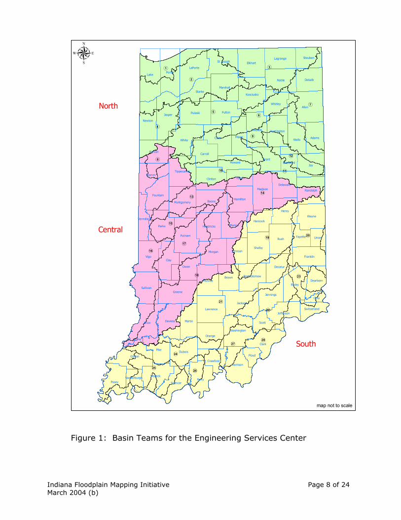
The Engineering Services Center During the reorganization of the Division of Water in 1999, Division leaders recognized one of the weaknesses of the Division was a lack of diverse work opportunities for the various engineering staff. Most engineering positions were assigned to one specific section, and engineers did not have a chance to interact with other staff or expand their expertise. This was causing the Division to lose staff as inequities in work products and expectations varied widely across the Division. The answer to this dilemma was the creation of the Engineering Services Center (ESC), and the concept of basin teams. Most engineering staff were moved into one large section, and the section then divided into three teams. Each team was assigned a portion of the state based on watersheds (see Figure 1), and engineering tasks that were handled by engineers previously scattered throughout the Division were assigned to the ESC. These day-to-day tasks are managed by the Engineering Section Managers, one for each basin. While the ESC is under the direction of the Engineering Services Branch (led by Kenneth E. Smith, P.E., Assistant Director of the Division), ESC staff works closely with all three branches of the Division, along with many other partners both within the Department and with other agencies, consulting engineers, and the general public.
Indiana Floodplain Mapping Initiative Page 6 of 24 March 2004 (b)
Another target of the reorganization was an analysis of the work products assigned to ESC, with an eye towards diversifying work for the engineering staff, and reducing inefficiencies in the performance of these tasks. Initiatives that have been undertaken and completed include:
• The creation of the General Guidelines for the Hydrologic � Hydraulic Assessment of Floodplains in Indiana, which provided a guideline for modelers to follow for the successful submission of projects to the Division�s office.
• The Hydrologic / Hydraulic Models and Assessments portion of the Division�s website, which includes many of the Division�s publications online, and has a catalog of previous modeling (including all FIS models) available for download.
• The publication of Natural Resources Commission Information Bulletin #37, (see appendix) which defines the review procedure for submittals to our office.
• The establishment, concurrently with the ESC, of the Technical Services Center (TSC), which has taken on many of the less complex tasks previously performed by engineering staff, but that other qualified staff could perform. The TSC is also set up similarly to ESC in that they are also divided into basin teams.
Surveying and Mapping Section The Surveying / Mapping Section provides surveying support for the Division's engineering studies by surveying high water marks, establishing benchmarks, and generating topographic maps. They specialize in obtaining field data (stream cross sections and bridge profiles) for use in hydraulic modeling studies. Floodplain Management Section
The Floodplain Management Section is responsible for the administration of the State�s participation in the Community Assistance Program-State Support Services Element (CAP-SSSE) in support of the National Flood Insurance Program (NFIP). Under this program, the Section is involved in a wide variety of responsibilities that focus on support for local communities that participate in the NFIP. Typical activities conducted by the Section include:
• Conducting Community Assistance Visits for FEMA. Serving as an in-
state point of contact for support of NFIP objectives. • Reviewing community floodplain ordinances for compliance with
federal and state regulations.
Indiana Floodplain Mapping Initiative Page 7 of 24 March 2004 (b)
• Conducting community outreach activities including annual workshops for training of local floodplain administrators; bi-annual publication of the newsletter �Waterlines�; publishing various educational documents.
• Providing general technical assistance to requests for information or assistance related to the National Flood Insurance Program.
• Assisting with final meetings for publication of floodplain mapping • Providing assistance to local officials in post-flood recovery efforts in
order to ensure compliance with NFIP requirements and to assist in minimizing future flood loss.
In addition the Section conducts outreach activities and training for local officials on state floodplain regulations and assists with monitoring for compliance with the Indiana Flood Control Act and the Indiana Floodplain Management Act in local communities.
Indiana Floodplain Mapping Initiative Page 8 of 24 March 2004 (b)
(21
(18
(16
(2
(9
(5
(19
(3
(14
(20
(28
(7
(17
(22
(24
(4
(6
(13
(10 (11
(25
(1
(12
(27
(15
(23
(8
(26
Allen
Lake
Jay
Knox
Vigo
CassWhite
Jasper
Porter
Clay
Pike
Rush
LaPorte
Parke
Greene
Clark
Grant
Ripley
Perry
Gibson
Noble
Posey
Wells
Boone
Owen
Elkhart
Henry
Jackson
Miami
Dubois
Putnam
Pulaski
Shelby
Fulton
Marion
Wayne
Sullivan
Clinton
Carroll
Harrison
Benton
Daviess
Kosciusko
Orange
Madison
Monroe
Morgan
Marshall
Martin
Dekalb
Wabash
Newton
Warrick
Adams
Brown
Warren
Spencer
Franklin
Starke
Randolph
St Joseph
Decatur
Lawrence
Fountain
Whitley
Hamilton
Tippecanoe
Washington
Jennings
Delaware
Hendricks
Lagrange
Tipton
Montgomery
Jefferson
Steuben
Johnson
Howard
Scott
Hancock
Huntington
Crawford
DearbornBartholomew
Fayette Union
Floyd
Vermillion
Switzerland
Ohio
Vanderburgh
Blackford
North
Central
South
µ
map not to scale
Figure 1: Basin Teams for the Engineering Services Center
Indiana Floodplain Mapping Initiative Page 9 of 24 March 2004 (b)
The Indiana Floodplain Mapping Initiative In conjunction with the goals of both the National Flood Insurance Program and the Indiana Department of Natural Resources, Division of Water, this plan details the creation of the Indiana Floodplain Mapping Initiative, which strives to meet the primary goals of the Map Modernization plan (alternatively known as CAP-MAP) established by FEMA. These goals are:
1. To establish and maintain a premier data collection system 2. To achieve effective program management 3. To build and maintain mutually beneficial partnerships 4. To expand and better inform the user community
These goals are inherent in the four major program areas of the initiative, which are base map data development, floodplain data development, mapping revision support and general program support. Base map data development The State of Indiana is poised to create a statewide consortium on Geographic Information Systems (GIS). The thought behind this idea would be to have GIS data created on the county level available for general use statewide, and to have data created on a statewide basis available to the counties and communities in the State. Potentially included in this project would be an inventory of base map information for the state of Indiana, and a source for digital base map information for creating DFIRM�s. A potential part of this consortium would be the creation of a mechanism for the delivery and storage of GIS data, which the Division would advocate include floodplain mapping data. While this is not quite a reality yet, staff are hopeful that legislation will come about in 2004 in this regard. The Department is among those agencies spearheading this effort, and the Division has made it known that such an effort would enhance its plan for improving floodplain mapping. The �Indiana Map Prospectus� is one such statewide GIS effort that has been proposed (see appendix). The Divison would anticipate that even if funding and direction for this statewide GIS group does not come from our state legislature, that such a group would come together informally. A majority of the base mapping information that is available now has been used in the Division�s project to digitally convert and rectify floodplain maps. As better base data sources become available, this data would be able to be incorporated into the DFIRM�s that are being created.
Indiana Floodplain Mapping Initiative Page 10 of 24 March 2004 (b)
Floodplain data development Digitizing existing floodplain maps and creation of DFIRM�s: The Division is already underway with a project to digitally convert existing floodplain mapping, through a contract with Prison Enterprises Network (PEN). The first phase of this project is the digital conversion of existing floodplain mapping for 80 counties, rectification of these floodplain themes to USGS Digital Orthophoto Quadrangles, and conversion of this information to DFIRM format. This phase is in progress and is slated for completion in July 2004. The second phase of our project with PEN is the population and attribution of the DFIRM coverages created in the first phase and the creation of �camera ready� DFIRM�s (including FIS text) for publication. Staff anticipates the start of the second phase in early 2004. Creation of these products (the other 12 counties have already been digitally converted by FEMA, or are on schedule to be completed) will put all of the floodplain data for Indiana in one format, which is FEMA compliant and digitally available, and is easily updated and maintained. Entire statewide coverage means that no county is left behind in the process of Map Modernization; no matter how rural a county, they will have improved mapping products, although major updates and revisions will be concentrated in high population and high growth areas.
Creation of new floodplain studies: The Division proposes to manage the creation of new studies directly through a Cooperating Technical Partner (CTP) agreement with FEMA. ESC would be responsible for the development of detailed floodway and flood boundary studies for publication in Flood Insurance Studies statewide, with funding through the CTP from FEMA. Staff would also be responsible for the QA/QC of studies that are funded through local CTP agreements, or the Division may contract studies using funding through CTP. For assistance with these studies, this proposal is for the Department to contract with three Indiana-based engineering consultants, as follows:
• The Division would issue a request for proposal for engineering services, which would run for a set period of time (for example, two years, with a two year extension), but with no set dollar amount (although a cap would be set).
• From responses, staff would select three separate contractors, one working with each basin team.
• Staff would then set the scope with the selected contractor for specific tasks, piece by piece. Tasks could be either performing the studies
Indiana Floodplain Mapping Initiative Page 11 of 24 March 2004 (b)
(and having the Division QA/QC), or having the consultants QA/QC studies that staff have done.
There are a number of reasons why such a process would be beneficial to the State of Indiana, while also meeting the goals of the NFIP and of Map Modernization.
• One of the problems with the mapping process as it exists now is that
FEMA contracts with their consultant (normally based outside of Indiana), but the ESC will do the review and provide most of the comments regarding new studies. Therefore, when problems and concerns arise, the consultant does not have direct guidance from the reviewer in completing the contract, which has caused delays in map production in the past. If the contract is with the Division, the contractor will know up front that they will have to deal with the Division�s expectations and follow its standards.
• By keeping the studies in state, the Division would also be developing hydrology & hydraulics expertise in consulting firms within Indiana.
• It is beneficial to have ESC staff involved with both the production of new studies and the QA/QC of studies the Division may contract out. Well rounded staff members that are able to look at studies from both points of view will be more efficient and perform higher quality work than if they were concentrated on one task or the other.
Refinement / Development of Approximate A Zones: �Unnumbered� A zones would be developed in rural / low development potential areas by using automated hydrologic & hydraulic methods, with funding through CTP. Existing A zones would be refined on an as-needed basis. The Department may then seek to contract this work out, through perhaps another governmental agency or university. General Surveying: This would include bridge surveys, stream cross section surveys and benchmark establishment for the support of floodplain mapping studies. The Surveying and Mapping Section of the Division of Water is a full function survey unit that has vast experience in performing surveys for Flood Insurance Study work. Therefore, staff would be looking to use CTP monies to fund the tasks of the Surveying and Mapping Section related to floodplain mapping projects. Mapping revision support The Division proposes that the Engineering Services Center serve as the reviewer for applications for Letters of Map Revision (and Conditional Letters
Indiana Floodplain Mapping Initiative Page 12 of 24 March 2004 (b)
of Map Revision) not only from the state�s perspective (which staff already does), but also as the final review for FEMA. Unlike now, the Division would anticipate receiving funding through CAP-MAP or CTP for the performance of this task.
Having final review responsibilities for LOMR�s resting with the Division of Water would benefit both the NFIP and the citizens of the State of Indiana in many ways:
• Duplication of time and effort would be eliminated. As part of the
Floodplain Management Rules of the State of Indiana, the Division of Water must approve all base flood elevations and floodway delineations used for floodplain management. Therefore, now there are reviews of these applications both at the state and federal level. This is an inefficient use of time and resources that could be applied to other mapping tasks, and would result in more timely LOMR production.
• The ESC has the technical knowledge and capability to perform these tasks, and since staff already has review responsibilities for these products, minimal training would be needed to get the program up and running.
• Many times ESC is reviewing models created for LOMR�s not only for that purpose, but also for approval of a State permit for Construction in a Floodway. With all the review being handled completely by the ESC, the requirements for a LOMR can be seamlessly integrated with State requirements.
The Mapping Coordinating Contractor (MCC, now known as the National Service Provider or NSP), who now serves as the final reviewers of LOMR�s for FEMA, would still be responsible for processing these letters. Staff works closely with the MCC, and anticipates that this would still be the case. For other map revisions (Letters of Map Amendment and Letters of Map Revision based on Fill), typically these revisions are not impacting the floodway, which is where the jurisdiction of the Department is defined. Therefore, staff would still rely on the new NSP to review and process these types of applications. General program support Under the proposed Indiana Floodplain Mapping Initiative, the Floodplain Management Section would be tasked and funded through CAP-MAP to help support the initiative by taking over the administration of the following activities:
Indiana Floodplain Mapping Initiative Page 13 of 24 March 2004 (b)
• Taking the lead role in the management of the various grants and contracts including tracking of various monies, accounting procedures, grant administration and contract compliance.
• Taking lead role in conducting Scoping Meetings and Final Meetings in support of mapping projects. The Floodplain Management Section would serve as the main liaison between the local community officials and Engineering Services and would monitor community compliance with necessary floodplain ordinance updates and public notice requirements.
• Providing various outreach activities including informational mailings, preparation of multi-media presentations and other support data as required for the mapping initiative.
Indiana Floodplain Mapping Initiative Page 14 of 24 March 2004 (b)
Workflow Analysis for the Engineering Services Center With the variety of work products in which the ESC is involved, it is necessary to analyze the different tasks that staff are charged with, to determine how much time can be allocated to various tasks. The Division is also in the process of establishing time management software, and therefore will need to define work processes for that effort. Following is a discussion of the various staff work products, and an estimate of time needed for completion of these tasks. Stream Permit and Floodplain Analysis / Regulatory Assessment (FARA) Review
Staff engineers are responsible for the review of submitted modeling in support of an application for construction in a floodway under Indiana Code 14-28-1, and other supporting statutes and rules. This usually involves the review of hydraulic modeling submitted by an engineering firm that would need to demonstrate that a proposed project would not cause the 100-year frequency flood stage to rise more than .14 feet. This may also involve the review of the project description for accuracy and completeness, the review of plans and specifications submitted in support of an application, and general coordination of various other aspects of staff review. Floodplain Analysis / Regulatory Assessment letters (FARA�s, previously known as recommendation letters) are a review of a site for determination of the floodway and base flood elevations, and a summary of the appropriate floodplain management regulations that would apply to construction activities for the site. These letters are generally requested by the site developer, landowner, or other interested party at the request of the local floodplain manager, who is required by their local floodplain ordinance to have a determination from the Division for a floodplain that does not have a detailed study. However, it will be the requestor�s burden to have such a study performed. The review by ESC of submittals for either a Stream Permit or for a FARA is governed by the procedure set out in the Natural Resources Commission Information Bulletin #37 (see appendix). This procedure includes the following details:
• Modeling will be performed based on the IDNR document General Guidelines for the Hydrologic � Hydraulic Assessment of Floodplains in Indiana.
• Modeling will not be reviewed unless the submittal includes a completed modeling checklist and a completed project evaluation table (if necessary).
Indiana Floodplain Mapping Initiative Page 15 of 24 March 2004 (b)
• ESC staff will only review modeling twice, and if the models are not acceptable, the application will be denied.
Dam Safety
ESC staff is responsible for the review of a permit application or an early coordination request for the evaluation of the safety of an existing or proposed dam. ESC focuses on the hydrologic and hydraulic aspects of these reviews, including a determination of spillway capacity and, in some cases, the review of a dam breach model. In 2000, the DNR was allocated a sum of $10 million to study and repair dams owned by the Department. ESC is working with consulting engineers hired to undertake these studies, and will be responsible for reviewing and approving the hydrologic and hydraulic aspects of these studies. Letter of Map Revision (LOMR) A Letter of Map Revision (LOMR) is a request to the Federal Emergency Management Agency (FEMA) to change base flood elevations and floodway limits that are published on the Flood Insurance Rate Maps (FIRM�s). Since determinations and delineations of floodway and flood fringe areas are subject to Department approval, the Division is obligated to review and approve these requests. In the past, these applications have been reviewed by both the Division (through ESC) and by FEMA (by the MCC). This duplicate review is redundant and inefficient. This plan introduces the concept of the Division being the sole reviewer of LOMR�s that are in its jurisdiction, with FEMA funding the Division for this service.
FEMA Flood Insurance Study / DFIRM production
With the advent of Map Modernization and the realization of significant funding for this program, the way that Flood Insurance Studies are created is undergoing a dramatic shift. The ESC has traditionally had a role in these studies in that staff has been the main reviewer of FEMA contracted studies, and have created a number of in-house studies for publication. This plan introduces the concept of the Division taking a larger role in the review and completion of Flood Insurance Studies. Staff proposes contracting for these studies through a Cooperating Technical Partner (CTP) agreement with FEMA. The Division has instituted a procedure for digital conversion of existing maps and eventual conversion to a DFIRM product through a contract with Prison Enterprises Network. Staff has a plan for contracting of new studies by the state to various consulting firms within the
Indiana Floodplain Mapping Initiative Page 16 of 24 March 2004 (b)
state. The Division also has as part of this plan for ESC to perform detailed studies for publication in Flood Insurance Studies.
ESC staff is also responsible for the review of (or the performance of) a hydrologic analysis for publication of discharge - drainage area curves for a particular watershed, often in conjunction with the Flood Insurance Study review. The resulting discharge � drainage area curves are then sent to the U. S. Geological Survey, the Corps of Engineers and the Natural Resources Conservation Service, per a Memorandum of Agreement dated May 6, 1976. Once these agencies have given their concurrence to the curves, they are published in the document �Coordinated Discharges of Selected Streams in Indiana�, and are used by all agencies.
County Surveyor Drainage Review (Senate Enrolled Act 368)
A newer role for the ESC is serving as a facilitator in an application process for county drainage projects. The ESC�s role in this process is to facilitate dialog between county surveyors and various environmental agencies (the Indiana Department of Environmental Management, the Division�s Environmental Unit, the Division of Soil Conservation, etc.) to come to a consensus on project scopes and limits that are acceptable to both parties. This entails a meeting on site to review the proposed project, and for all parties to agree on conditions for the project.
Violations and Enforcement The ESC does perform a limited role in supporting the Division�s compliance activity related to the investigation of potential violations of the Flood Control Act. The ESC will perform limited modeling to determine floodway limits for potential violation sites, if warranted. ESC staff has also served as expert witnesses in court proceedings regarding compliance matters.
Other duties
Other duties the ESC is involved with are flood response and recovery (Indiana had two federally declared flooding related disasters in 2003), reviewing water use / water supply studies, support of conservancy district, basin commission and lake management issues, and other special projects that may come up from time to time. ESC task allocation As of the start of 2004, the Engineering Services Center has the following staff assignments (see Table 1):
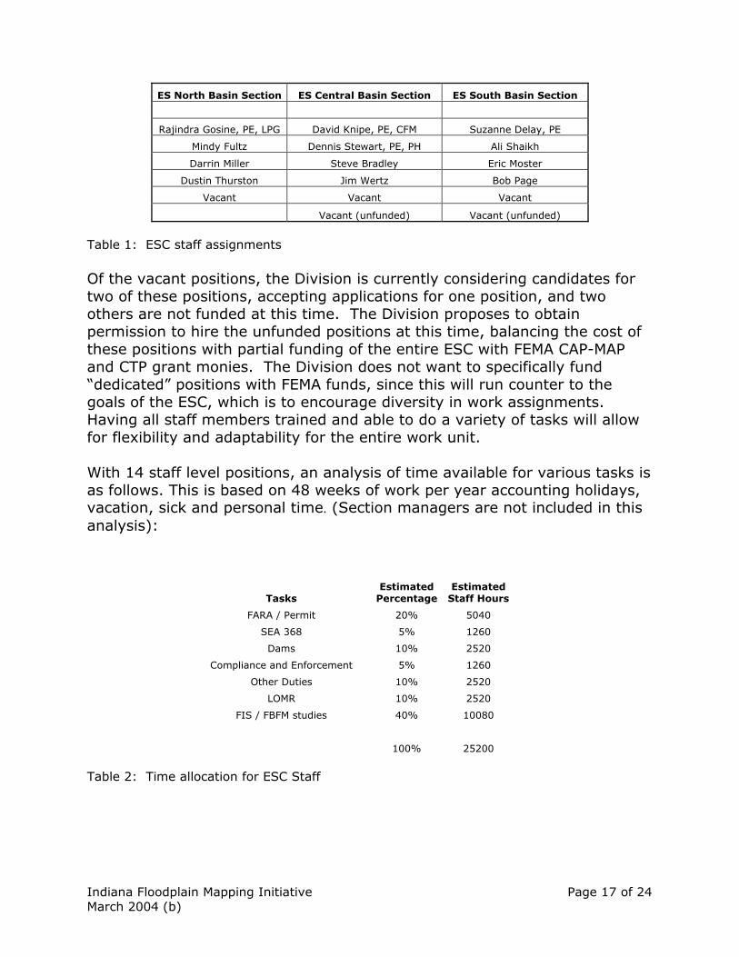
Indiana Floodplain Mapping Initiative Page 17 of 24 March 2004 (b)
ES North Basin Section ES Central Basin Section ES South Basin Section
Rajindra Gosine, PE, LPG David Knipe, PE, CFM Suzanne Delay, PE
Mindy Fultz Dennis Stewart, PE, PH Ali Shaikh
Darrin Miller Steve Bradley Eric Moster
Dustin Thurston Jim Wertz Bob Page
Vacant Vacant Vacant
Vacant (unfunded) Vacant (unfunded)
Table 1: ESC staff assignments Of the vacant positions, the Division is currently considering candidates for two of these positions, accepting applications for one position, and two others are not funded at this time. The Division proposes to obtain permission to hire the unfunded positions at this time, balancing the cost of these positions with partial funding of the entire ESC with FEMA CAP-MAP and CTP grant monies. The Division does not want to specifically fund �dedicated� positions with FEMA funds, since this will run counter to the goals of the ESC, which is to encourage diversity in work assignments. Having all staff members trained and able to do a variety of tasks will allow for flexibility and adaptability for the entire work unit. With 14 staff level positions, an analysis of time available for various tasks is as follows. This is based on 48 weeks of work per year accounting holidays, vacation, sick and personal time. (Section managers are not included in this analysis):
Tasks Estimated
PercentageEstimated
Staff Hours
FARA / Permit 20% 5040
SEA 368 5% 1260
Dams 10% 2520
Compliance and Enforcement 5% 1260
Other Duties 10% 2520
LOMR 10% 2520
FIS / FBFM studies 40% 10080
100% 25200 Table 2: Time allocation for ESC Staff
Indiana Floodplain Mapping Initiative Page 18 of 24 March 2004 (b)
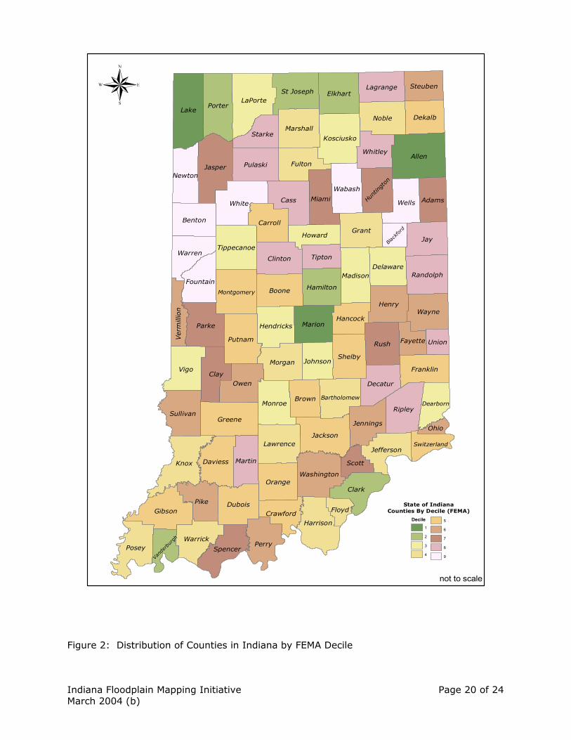
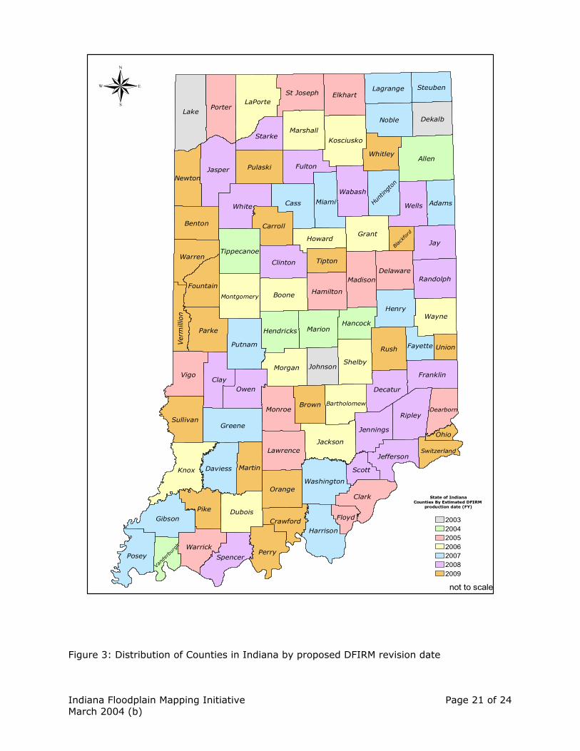
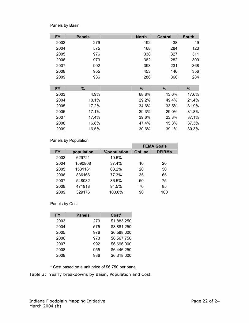
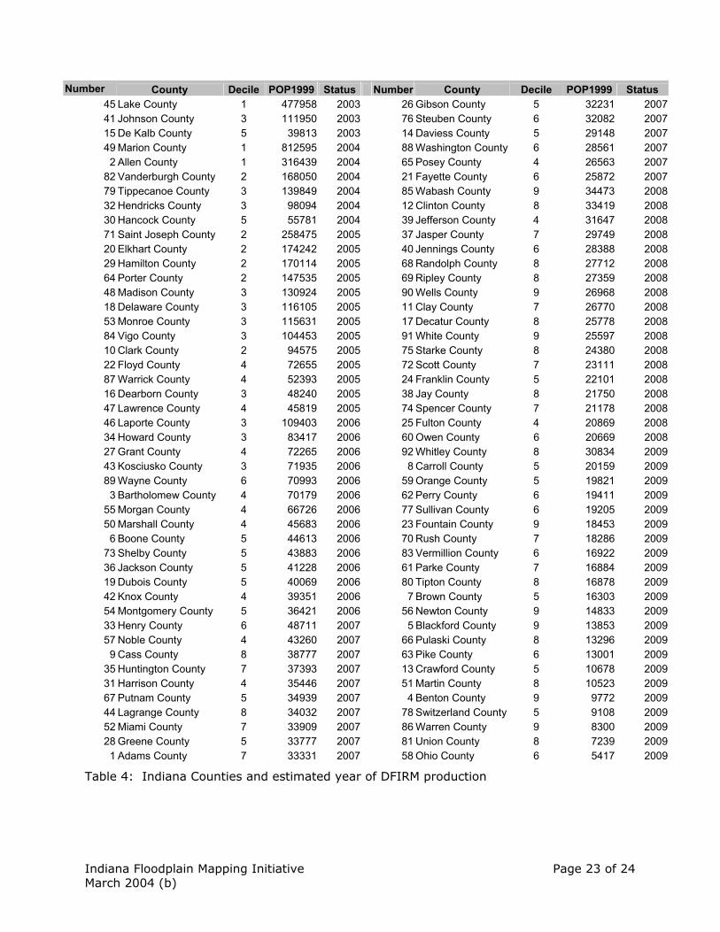
Time Tracking and reporting The Division of Water is initiating a plan for time tracking throughout the Division by using an application developed by the Division of Fish and Wildlife. This initiative fits in with the goals of this plan, since time will have to be tracked for each of the processes staff proposes to be working on. Since time spent on FEMA work (FIS and LOMR) will need to be tracked and monitored by the ESC section managers, this tool will be a critical piece of the implementation of this plan. The ESC section managers will be reporting the results from this database on a monthly basis (reports due on the 5th of each month) regarding the amount of time spent on each task, and how much time each staff member is credited to each work plan. The amount of time spent on federal obligations will also be reported, with the expectation that time spent on these tasks will be reimbursed through the CTP or CAP MAP programs. In addition, FEMA (through their National Service Provider) is developing a web based tool for the planning and tracking of CTP and CAP MAP activities. This tool will be made available to all of FEMA�s partners, and would be updated by Division staff on an ongoing basis. Prioritization of Counties for DFIRM conversion The previous Map Modernization plan developed by FEMA and the Division published in 2002 (see appendix) identified priorities by county, based on a consensus between FEMA and Division goals. Since these goals have shifted over time, these priorities have also had to be adjusted slightly. Included in the appendix is a list of priorities of each county, and an estimate of which fiscal year a revised DFIRM product would be produced. The Division anticipates that much of the data compilation and graphical work would be done through its partnership with PEN Products, in many cases well ahead of the date a study may be initiated. As part of this plan, staff has developed a prioritization of county DFIRM production, and an estimated year (federal fiscal year) that a county will be converted. These estimated time frames are based on the following constraints:
• Set schedules for FY03 and FY04 • A constant set of funding for 5 years (FY05 � FY09) • Meeting FEMA�s goals on percentage of population served by each
fiscal year (population with digital data and population with effective maps)
• FEMA�s �decile� count, based on priorities for the entire country
Indiana Floodplain Mapping Initiative Page 19 of 24 March 2004 (b)
• Not overloading one basin team in a given year • Panel Count is based on a study by PBS & J (for FEMA)
Tables 3 and 4 and Figures 2 and 3 depict the results of this analysis for the entire state. This determination should only be taken as a preliminary analysis, for many other factors that were not considered in this analysis should be taken into account, including:
• CTP agreements with local communities � if a local community is willing to provide resources and data to help the mapping process, then priority should be given to those communities.
• The IDNR digital conversion project � the Division�s timelines will be much more aggressive than FEMA�s, since it is not planning wide scale redelinations. If there are counties where redelinations aren�t necessary (or would be minor in scope), then Division data can still be used as a base for refinement of flood zones.
• Costs are based on digital conversion only, and that estimate is based on $6,750 per panel, from the 2002 Map Modernization study. Staff expects its product to be much cheaper than that, and plan to apply any savings to detailed studies.
• Detailed studies that may exist or that may be planned by IDNR are also not taken into account. Staff plans to make an effort to incorporate any detailed study at the time of conversion, but the process of conversion will expedite the incorporation of detailed studies into the DFIRM at a later date.
Indiana Floodplain Mapping Initiative Page 20 of 24 March 2004 (b)
Figure 2: Distribution of Counties in Indiana by FEMA Decile
Allen
Lake
Jay
Knox
Vigo
CassWhite
Jasper
Porter
Clay
Pike
Rush
LaPorte
Parke
Greene
Ripley
Grant
Noble
Perry
Clark
Gibson
Posey
Wells
Owen
Boone
Elkhart
Henry
Jackson
Miami
Dubois
Putnam
Pulaski
Shelby
Fulton
Marion
Wayne
Clinton
Harrison
Benton
Sullivan
Carroll
Daviess
Kosciusko
Orange
Monroe
Madison
Morgan
Marshall
Martin
Newton
Wabash
Dekalb
Warrick
Adams
Brown
Warren
Spencer
Franklin
Randolph
Lawrence
Starke
St Joseph
Decatur
Fountain
Whitley
Hamilton
Tippecanoe
Washington
Jennings
Delaware
Lagrange
Hendricks
Tipton
Montgomery
Jefferson
Johnson
Steuben
Howard
Scott
Hancock
Hunt
ingt
on
Crawford
DearbornBartholomew
Fayette Union
Floyd
Ver
mill
ion
Switzerland
Ohio
Vand
erbu
rgh
Blac
kfor
d
State of IndianaCounties By Decile (FEMA)
Decile1
2
3
4
5
6
7
8
9
®
not to scale
Indiana Floodplain Mapping Initiative Page 21 of 24 March 2004 (b)
Figure 3: Distribution of Counties in Indiana by proposed DFIRM revision date
Allen
Lake
Jay
Knox
Vigo
CassWhite
Jasper
Porter
Clay
Pike
Rush
LaPorte
Parke
Greene
Ripley
Grant
Noble
Perry
Clark
Gibson
Posey
Wells
Owen
Boone
Elkhart
Henry
Jackson
Miami
Dubois
Putnam
Pulaski
Shelby
Fulton
Marion
Wayne
Clinton
Harrison
Benton
Sullivan
Carroll
Daviess
Kosciusko
Orange
Monroe
Madison
Morgan
Marshall
Martin
Newton
Wabash
Dekalb
Warrick
Adams
Brown
Warren
Spencer
Franklin
Randolph
Lawrence
Starke
St Joseph
Decatur
Fountain
Whitley
Hamilton
Tippecanoe
Washington
Jennings
Delaware
Lagrange
Hendricks
Tipton
Montgomery
Jefferson
Johnson
Steuben
Howard
Scott
Hancock
Hunt
ingt
on
Crawford
DearbornBartholomew
Fayette Union
Floyd
Ver
mill
ion
Switzerland
Ohio
Vand
erbu
rgh
Blac
kfor
d
State of IndianaCounties By Estimated DFIRM
production date (FY)
2003200420052006200720082009
®
not to scale
Indiana Floodplain Mapping Initiative Page 22 of 24 March 2004 (b)
Panels by Basin
FY Panels North Central South 2003 279 192 38 49 2004 575 168 284 123 2005 976 338 327 311 2006 973 382 282 309 2007 992 393 231 368 2008 955 453 146 356 2009 936 286 366 284
FY % % % % 2003 4.9% 68.8% 13.6% 17.6% 2004 10.1% 29.2% 49.4% 21.4% 2005 17.2% 34.6% 33.5% 31.9% 2006 17.1% 39.3% 29.0% 31.8% 2007 17.4% 39.6% 23.3% 37.1% 2008 16.8% 47.4% 15.3% 37.3% 2009 16.5% 30.6% 39.1% 30.3%
Panels by Population FEMA Goals
FY population %population OnLine DFIRMs 2003 629721 10.6% 2004 1590808 37.4% 10 20 2005 1531161 63.2% 20 50 2006 836166 77.3% 35 65 2007 548032 86.5% 50 75 2008 471918 94.5% 70 85 2009 329176 100.0% 90 100
Panels by Cost
FY Panels Cost* 2003 279 $1,883,250 2004 575 $3,881,250 2005 976 $6,588,000 2006 973 $6,567,750 2007 992 $6,696,000 2008 955 $6,446,250 2009 936 $6,318,000
* Cost based on a unit price of $6,750 per panel
Table 3: Yearly breakdowns by Basin, Population and Cost
Indiana Floodplain Mapping Initiative Page 23 of 24 March 2004 (b)
Number County Decile POP1999 Status Number County Decile POP1999 Status
45 Lake County 1 477958 2003 26 Gibson County 5 32231 200741 Johnson County 3 111950 2003 76 Steuben County 6 32082 200715 De Kalb County 5 39813 2003 14 Daviess County 5 29148 200749 Marion County 1 812595 2004 88 Washington County 6 28561 20072 Allen County 1 316439 2004 65 Posey County 4 26563 2007
82 Vanderburgh County 2 168050 2004 21 Fayette County 6 25872 200779 Tippecanoe County 3 139849 2004 85 Wabash County 9 34473 200832 Hendricks County 3 98094 2004 12 Clinton County 8 33419 200830 Hancock County 5 55781 2004 39 Jefferson County 4 31647 200871 Saint Joseph County 2 258475 2005 37 Jasper County 7 29749 200820 Elkhart County 2 174242 2005 40 Jennings County 6 28388 200829 Hamilton County 2 170114 2005 68 Randolph County 8 27712 200864 Porter County 2 147535 2005 69 Ripley County 8 27359 200848 Madison County 3 130924 2005 90 Wells County 9 26968 200818 Delaware County 3 116105 2005 11 Clay County 7 26770 200853 Monroe County 3 115631 2005 17 Decatur County 8 25778 200884 Vigo County 3 104453 2005 91 White County 9 25597 200810 Clark County 2 94575 2005 75 Starke County 8 24380 200822 Floyd County 4 72655 2005 72 Scott County 7 23111 200887 Warrick County 4 52393 2005 24 Franklin County 5 22101 200816 Dearborn County 3 48240 2005 38 Jay County 8 21750 200847 Lawrence County 4 45819 2005 74 Spencer County 7 21178 200846 Laporte County 3 109403 2006 25 Fulton County 4 20869 200834 Howard County 3 83417 2006 60 Owen County 6 20669 200827 Grant County 4 72265 2006 92 Whitley County 8 30834 200943 Kosciusko County 3 71935 2006 8 Carroll County 5 20159 200989 Wayne County 6 70993 2006 59 Orange County 5 19821 20093 Bartholomew County 4 70179 2006 62 Perry County 6 19411 2009
55 Morgan County 4 66726 2006 77 Sullivan County 6 19205 200950 Marshall County 4 45683 2006 23 Fountain County 9 18453 20096 Boone County 5 44613 2006 70 Rush County 7 18286 2009
73 Shelby County 5 43883 2006 83 Vermillion County 6 16922 200936 Jackson County 5 41228 2006 61 Parke County 7 16884 200919 Dubois County 5 40069 2006 80 Tipton County 8 16878 200942 Knox County 4 39351 2006 7 Brown County 5 16303 200954 Montgomery County 5 36421 2006 56 Newton County 9 14833 200933 Henry County 6 48711 2007 5 Blackford County 9 13853 200957 Noble County 4 43260 2007 66 Pulaski County 8 13296 20099 Cass County 8 38777 2007 63 Pike County 6 13001 2009
35 Huntington County 7 37393 2007 13 Crawford County 5 10678 200931 Harrison County 4 35446 2007 51 Martin County 8 10523 200967 Putnam County 5 34939 2007 4 Benton County 9 9772 200944 Lagrange County 8 34032 2007 78 Switzerland County 5 9108 200952 Miami County 7 33909 2007 86 Warren County 9 8300 200928 Greene County 5 33777 2007 81 Union County 8 7239 20091 Adams County 7 33331 2007 58 Ohio County 6 5417 2009
Table 4: Indiana Counties and estimated year of DFIRM production
Indiana Floodplain Mapping Initiative Page 24 of 24 March 2004 (b)
Conclusion This is the Indiana Department of Natural Resources conceptual proposal for the funding of NFIP mapping tasks for the purpose of modernizing and updating floodplain mapping. By having the Engineering Services Center and the Floodplain Management Section of the Division of Water assume responsibility for the digital conversion of floodplain mapping, for the creation of new floodplain mapping studies, and for managing the map revision process, these tasks can be completed concurrently and expediently. Both state and federal goals for revising floodplain mapping are addressed by this plan. The Division of Water, Department of Natural Resources is excited about the opportunities that exist in this plan, and is looking forward to a beneficial partnership with FEMA and with other stakeholders in the common goals to update and modernize floodplain mapping. Appendices Map Modernization plan for the State of Indiana, 2002 Indiana Map Prospectus Natural Resources Commission Bulletin #37 Division of Water Organization Chart Details on Time Tracking software application