UAV = Unmanned Aerial Vehicle UAS = Unmanned Aircraft System
Upload
northeast-arc-users-group-presentationsCategory
view
17download
1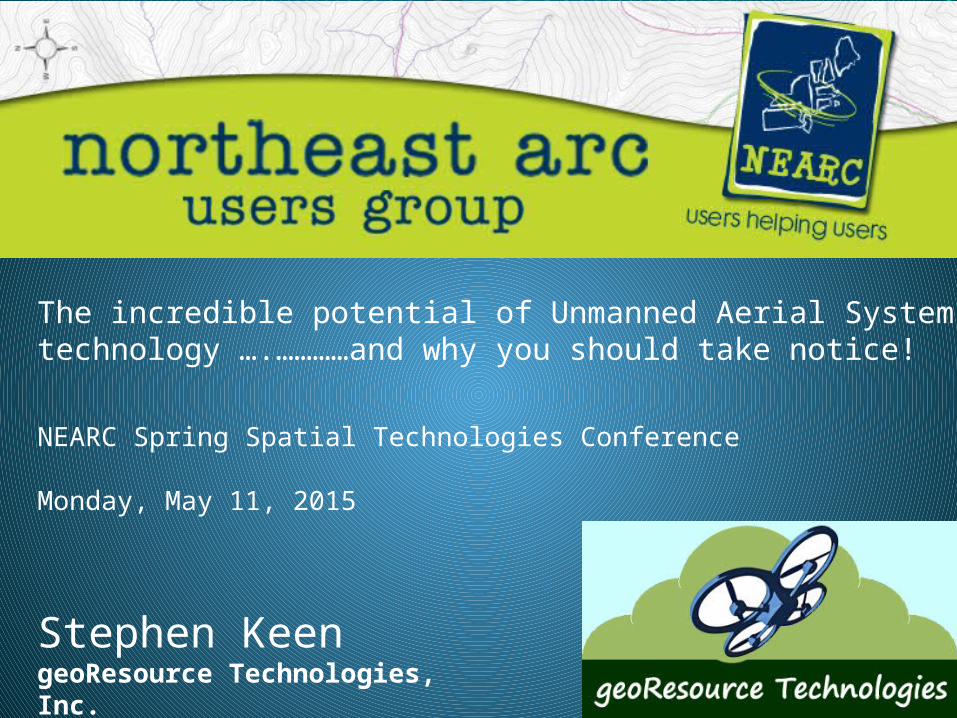
The incredible potential of Unmanned Aerial Systems technology ….…………and why you should take notice!
Stephen KeengeoResource Technologies, Inc.
NEARC Spring Spatial Technologies Conference
Monday, May 11, 2015

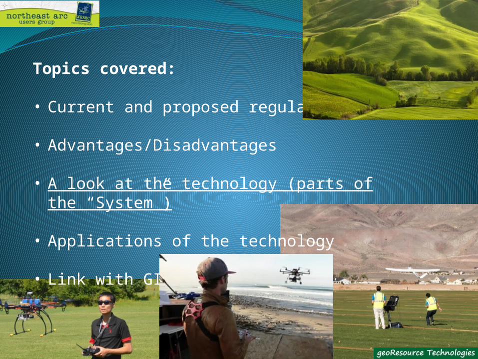
Topics covered:
• Current and proposed regulations
• Advantages/Disadvantages
• A look at the technology (parts of the “System”)
• Applications of the technology
• Link with GIS

Topics covered:
• Current and proposed regulations
• Advantages/Disadvantages
• A look at the technology (parts of the “System”)
• Applications of the technology
• Link with GIS

small Unmanned Aerial System (sUAS) – FAA designation
Also called:
• Drones
• Small Unmanned Aircraft (SUA)
• Unmanned Aerial Vehicles (UAV)
• Remotely Piloted Aircraft Systems (RPAS)
• Aerobot, Aerial Robot
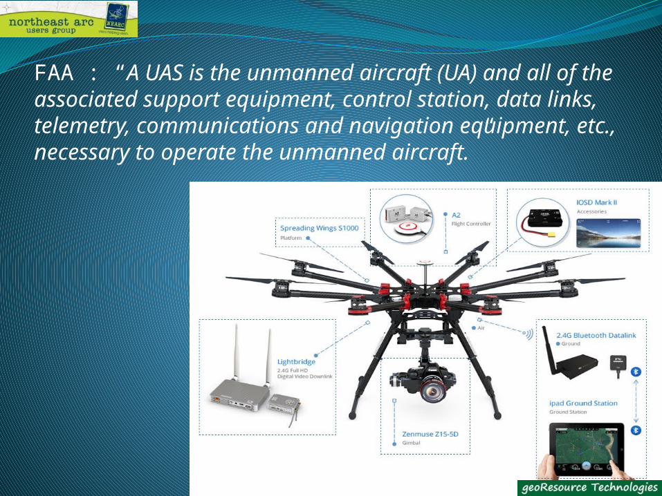
FAA : “A UAS is the unmanned aircraft (UA) and all of the associated support equipment, control station, data links, telemetry, communications and navigation equipment, etc., necessary to operate the unmanned aircraft.”
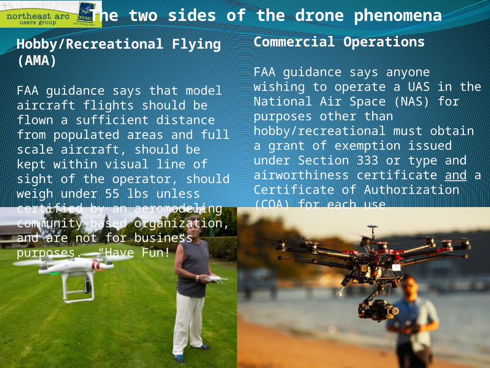
Commercial Operations
FAA guidance says anyone wishing to operate a UAS in the National Air Space (NAS) for purposes other than hobby/recreational must obtain a grant of exemption issued under Section 333 or type and airworthiness certificate and a Certificate of Authorization (COA) for each use.
Hobby/Recreational Flying (AMA)
FAA guidance says that model aircraft flights should be flown a sufficient distance from populated areas and full scale aircraft, should be kept within visual line of sight of the operator, should weigh under 55 lbs unless certified by an aeromodeling community-based organization, and are not for business purposes. “Have Fun!”
The two sides of the drone phenomena

Current FAA Section 333 Exemptions
• Specific UA are limited to less than 55 pounds including payload• All operations shall be conducted over private or controlled-access property with
permission from the property owner/controller or authorized representative. • Pilot in Command (PIC) must hold either an commercial, private, recreational, or
sport pilot certificate.• The UA may not be operated at a speed exceeding 100 miles per hour• The UA must be operated at an altitude of no more than 400 feet above ground• The UA must be operated within visual line of sight of the PIC at all times• All operations must utilize a visual observer (VO)• The operating/maintenance documents must be accessible during UAS ops.• UAS operations may not be conducted during night• The UA may not operate within 5 nautical miles of an airport
https://www.faa.gov/uas/legislative_programs/section_333/

The following provisions are being proposed in the FAA’s Small UAS Notice of Proposed Rulemaking (NPRM)
• Weigh less than 55 lbs. (25 kg)
• Visual line-of-sight (VLOS), unaided by any device other than corrective lenses
• Small unmanned aircraft may not operate over any persons not directly
involved in the operation
• Daylight-only operations
• Maximum airspeed of 100 mph (87 knots)
• Maximum altitude of 500 feet above ground level
• Minimum weather visibility of 3 miles from control station
• Operators would be required to pass an initial aeronautical knowledge test at
an FAA-approved knowledge testing center
• Be at least 17 years old
Latest Developments
• Comment period for the NPRM is over
• Creation of ‘Summary Grants’ to speed up the exemption process
• FAA will grant a Certificate of Waiver or Authorization (COA) for flights at or below 200
feet to any UAS operator with a Section 333 exemption for aircraft that weigh less than
55 pounds, operate during daytime Visual Flight Rules (VFR) conditions, operate within
visual line of sight (VLOS) of the pilots, and stay certain distances away from airports
• The FAA is working with industry partners on three focus areas, including
o Visual line-of-sight operations in urban areas (News gathering)
o Extended visual line-of-sight operations in rural areas
o Beyond visual line-of-sight in rural/isolated areas
• New FAA smartphone application called “B4UFLY,” designed to help model aircraft and
unmanned aircraft (UAS) users know if it is safe and legal to fly in their current or
planned location

Topics covered:
• Current and proposed regulations
• Advantages/Disadvantages
• A look at the technology (parts of the “System”)
• Applications of the technology
• Link with GIS

“Simply put, sUAS technology allows us the view the landscape from an elevated perspective” – it gives us information that may not just be difficult to determine from ground level, but may well be impossible.

ExtentsCost per unit area
Resolution AccuracySpeed/
Repeatability
Satellite Imagery
Aircraft Data Capture (Ortho/Photogrammetry)
Traditional Survey (Total station/GPS)
UAS (Drone)
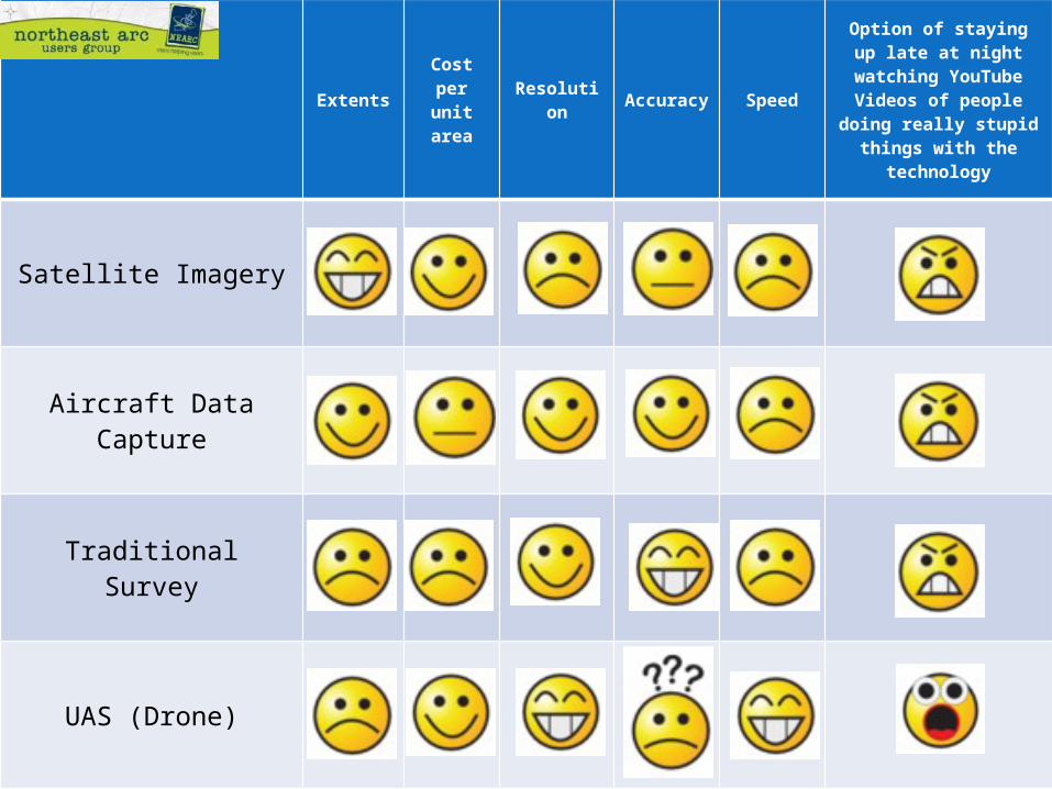
ExtentsCost per unit area
Resolution Accuracy Speed
Option of staying up late at night watching
YouTube Videos of people doing really
stupid things with the technology
Satellite Imagery
Aircraft Data Capture
Traditional Survey
UAS (Drone)
Topics covered:
• Current and proposed regulations
• Advantages/Disadvantages
• A look at the technology (parts of the “System”)
• Applications of the technology
• Link with GIS

• Multi-rotor - Shorter, slower flight with heavier payload*, vertical take-off
• Fixed-wing - Fly fast(er) and long(er) with small payload, take-off/landing area
• Hybrid
*DJI S1000 example:Max Takeoff Weight: 24 lbs Weight without camera and battery: 13.4 lbs.
Platform choice (match to application)
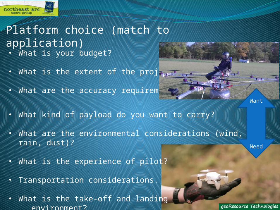
• What is your budget?
• What is the extent of the project?
• What are the accuracy requirement?
• What kind of payload do you want to carry?
• What are the environmental considerations (wind, rain, dust)?
• What is the experience of pilot?
• Transportation considerations.
• What is the take-off and landing environment?
Platform choice (match to application)
Want
Need
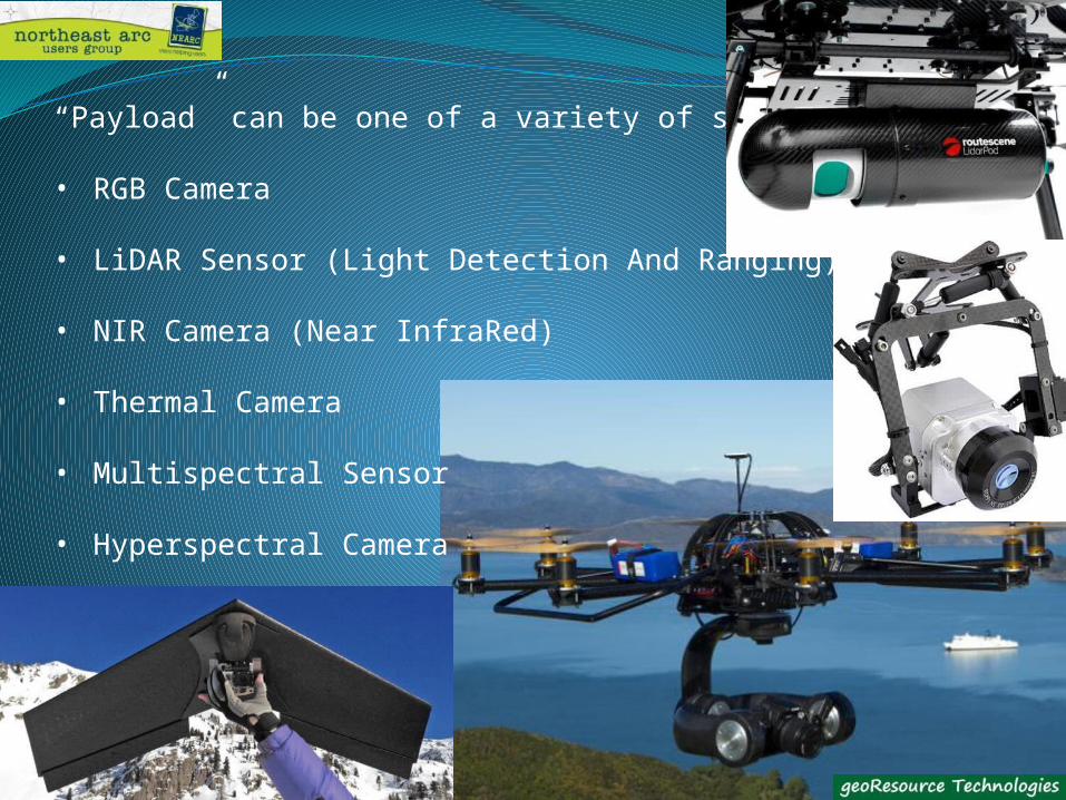
“Payload” can be one of a variety of sensors:
• RGB Camera
• LiDAR Sensor (Light Detection And Ranging)
• NIR Camera (Near InfraRed)
• Thermal Camera
• Multispectral Sensor
• Hyperspectral Camera

What do you get as a product:
• Video (90%?)
• Photograph/Image
• 3D Ground Surface (SfM)
• Point Cloud
• “Data”

Accuracy….depends on….
• Image Resolution (camera resolution, flight height, focal length)
• GPS Technology (and quality)
• Camera Position
• Ground Control
• Flight Planning (overlap, sidelap, flight height)
Without independent check points to verify accuracy there are currently no Absolutes. Therefore, you need to beVery careful how the data is used.
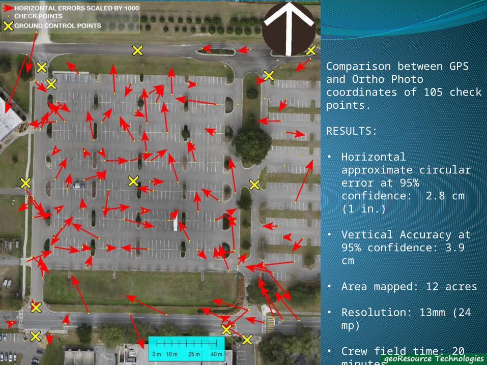
Comparison between GPS and Ortho Photo coordinates of 105 check points.
RESULTS:
• Horizontal approximate circular error at 95% confidence: 2.8 cm (1 in.)
• Vertical Accuracy at 95% confidence: 3.9 cm
• Area mapped: 12 acres
• Resolution: 13mm (24 mp)
• Crew field time: 20 minutes
• Ground Control (12 points), 15 minutes

Software: Ground Station, Flight Planning
• Set Attributes and ‘Waypoints’ for autonomous flight
• Altitude• Velocity• Waypoint locations• Turn types, Hold time• Warnings

Structure from Motion (SfM)
Image processing packages use (recognizable features in) overlapping images to extrapolate a 3D surface and create an “orthophogrammetric” image.

….or ‘Thin Client’ utilizing ‘Cloud Computing” – may sacrifice accuracy
Turning ‘Raw Data’ into an End Product requires either computing power ------>

Topics covered:
• Current and proposed regulations
• Advantages/Disadvantages
• A look at the technology (parts of the “System”)
• Applications of the technology
• Link with GIS

Applications:

Applications:
Mining and Volumetrics
3-D Models, Site Assessment
Energy Infrastructure Inspection
Wind Turbines/Solar
Electricity Infrastructure
Cell Towers Transportation Evaluation
Bridge Inspection
Intersection Mapping
Dam Inspections/Monitoring
Risk Management
Disaster Response/Mapping
Area Calculations
Outfall Inspections
Waterway Evaluation
Erosion Evaluation
Heat Mapping
Air Quality Monitoring
Railroad Assessment
Vegetation Analysis
Plume Mapping Impervious Area Mapping
Stormwater Fee Assessment Marketing
Public Outreach
Visualization (Picture/Video)
Story Telling (Scenarios)

Topics covered:
• Current and proposed regulations
• Advantages/Disadvantages
• A look at the technology (parts of the “System”)
• Applications of the technology
• Link with GIS
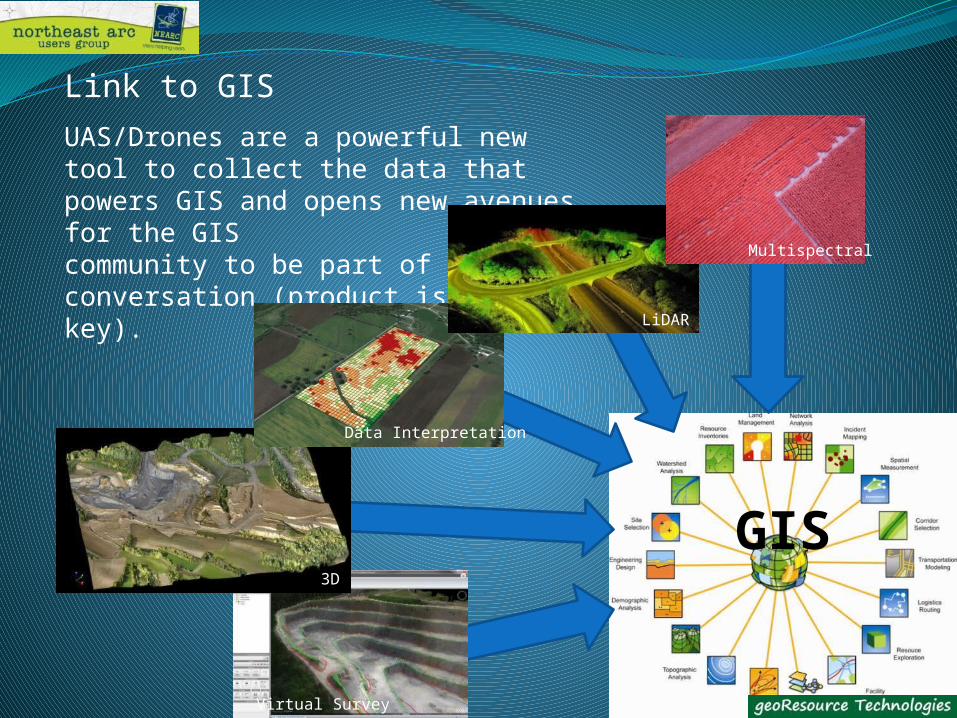
Link to GIS
UAS/Drones are a powerful new tool to collect the data that powers GIS and opens new avenues for the GIS community to be part of the conversation (product iskey).
GIS
Virtual Survey
3D
Data Interpretation
LiDAR
Multispectral

Who will “own a drone”?
• Specialist UAV service companies
• Traditional survey companies
• Traditional aerial imagery companies
• Traditional aerial imagery companies
• Engineering and construction
• Traditional visual arts companies
• Municipal entities
Adopters should be aware of and follow the rules (particularly in relation to safety), establish training, operation and maintenance procedures, keep up to date with the technological advances and carry good liability insurance.

QUESTIONS?