The Gulf Intracoastal Waterway in Texas...
106
THE GULF INTRACOASTAL WATERWAY IN TEXAS PRESENTED IN RESPONSE TO THE TEXAS COASTAL WATERWAY ACT OF 1975 AND SUBMITTED TO THE SEVENTY -FOURTH SESSION OF THE TEXAS LEGISLATURE PREPARED BY THE TEXAS DEPARTMENT OF TRANSPORTATION 1994
-
Upload
hoangtuyen -
Category
Documents
-
view
216 -
download
0
Transcript of The Gulf Intracoastal Waterway in Texas...
THE GULF INTRACOASTAL WATERWAY
IN TEXAS
PRESENTED IN RESPONSE TO
THE TEXAS COASTAL WATERWAY ACT OF 1975
AND
SUBMITTED TO THE SEVENTY -FOURTH SESSION
OF THE TEXAS LEGISLATURE
PREPARED BY THE
TEXAS DEPARTMENT OF TRANSPORTATION
1994
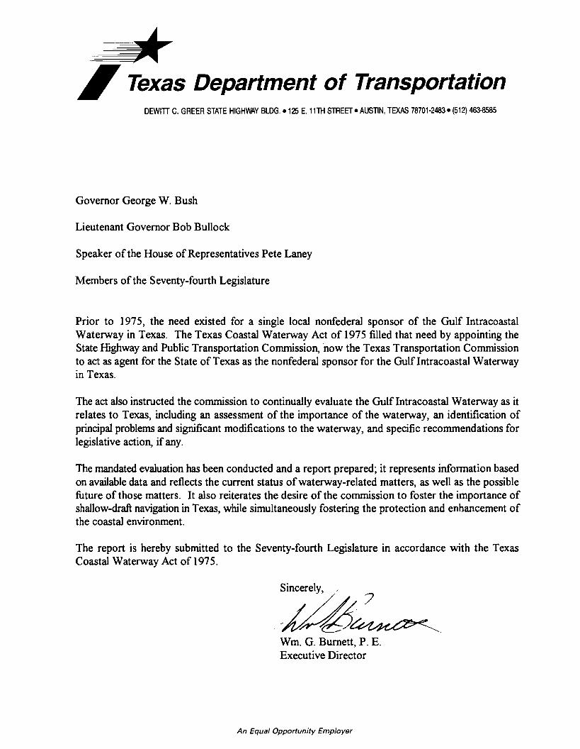
~ I Texas Department of Transportation DEWITI C. GREER STATE HIGHWAY BLDG.• 125 E. 11TH STREET• AUSTIN, TEXAS 78701-2483• (512) 463-8585
Governor George W. Bush
Lieutenant Governor Bob Bullock
Speaker of the House of Representatives Pete Laney
Members of the Seventy-fourth Legislature
Prior to 1975, the need existed for a single local nonfederal sponsor of the Gulf Intracoastal Waterway in Texas. The Texas Coastal Waterway Act of 1975 filled that need by appointing the State Highway and Public Transportation Commission, now the Texas Transportation Commission to act as agent for the State of Texas as the nonfederal sponsor for the Gulflntracoastal Waterway in Texas.
The act also instructed the commission to continually evaluate the Gulf Intracoastal Waterway as it relates to Texas, including an assessment of the importance of the waterway, an identification of principal problems and significant modifications to the waterway, and specific recommendations for legislative action, if any.
The mandated evaluation has been conducted and a report prepared; it represents information based on available data and reflects the current status of waterway-related matters, as well as the possible future of those matters. It also reiterates the desire of the commission to foster the importance of shallow-draft navigation in Texas, while simultaneously fostering the protection and enhancement of the coastal environment.
The report is hereby submitted to the Seventy-fourth Legislature in accordance with the Texas Coastal Waterway Act of 197 5.
Wm. G. Burnett, P. E. Executive Director
An Equal Opportunity Employer
TABLE OF CONTENTS
Page
EXECUTIVE SUMMARY lX
PREFACE xv
CHAPTER ONE THE TEXAS WATERWAY STORY 1
CHAPTER TWO THE LAGUNA MADRE 11
CHAPTER THREE REPORT OF SIGNIFICANT ACTIVITIES 29
CHAPTER FOUR LEGISLATIVE RECOMMENDATIONS 61
APPENDIX A THE ACQUISITION PROCESS 67
APPENDIX B RELATED FEDERAL LEGISLATION 75
APPENDIX C TEXAS COASTAL WATERWAY ACT OF 1975 81
BIBLIOGRAPHY 89
EXECUTIVE SUMMARY
EXECUTIVE SUMMARY
The Texas Department of Transportation's (TxDOT) primary area of
concentration for the Gulf Intracoastal Waterway (GIWW) during fiscal years
1993-1994 has been the Laguna Madre. Efforts to acquire a total of 750 upland
acres in the Baffin Bay area of the upper Laguna Madre were impeded by
opposition from the landowners, who cited concerns over the environmental
acceptability of the four proposed sites. The acquisition of these sites was
suspended on February 24, 1994 by the Texas Transportation Commission pending
the completion and review of the U.S. Army Corps of Engineers' (Corps) Section
216 feasibility study (see Appendix B) for the Corpus Christi Bay to Port Isabel
reach.
Dredging operations planned for March 1994 were te_mporarily deferred
in the lower Laguna Madre area due to concerns about the environmental impacts
of open-water disposal. TxDOT, the Corps, state and federal resource agencies,
and other special interest groups worked together to develop affordable and
environmentally acceptable interim disposal options for the GIWW's deferred
maintenance project from Port Isabel to Arroyo Colorado. However, several
environmental interest groups continued to oppose the Corps' final plan. When
activities for the GIWW's Port Isabel to Arroyo Colorado maintenance project
resumed in August 1994 after the temporary moratorium, the environmental
groups filed a lawsuit attempting to halt the open-water disposal practices. After
a week-long hearing, the judge's ruling allowed the maintenance project to
continue as planned and contracted.
During fiscal years 1993-1994, the Corps continued to conduct Section 216
Studies along the Texas GIWW. A study addressing the Sargent Beach area
Multimodal Operations Office JLR1994 lX
concluded in 1992, recommending the construction of an eight-mile, combination
concrete-block revetment and concrete sheetpile wall to protect the area from the
erosional forces of the Gulf of Mexico. Construction of the project is scheduled
to begin in 1995.
The Section 216 Studies addressing three other GIWW reaches, which are
currently underway and at various stages of the reconnaissance or feasibility
phases, include the following: the Aransas National Wildlife Refuge area, the
Corpus Christi Bay to Port Isabel reach, and the High Island to Brazos River
reach. The feasibility report addressing the Aransas National Wildlife Refuge
area is scheduled for finalization in 1995; the Corpus Christi Bay to Port Isabel
draft reconnaissance report was submitted for review to the Corps' Washington,
D.C. headquarters in July 1994; and the reconnaissance study addressing the High
Island to Brazos River reach is scheduled for completion and review in 1995.
There are three remaining GIWW reaches which are scheduled to begin between
1995 and 1997; however, each Section 216 Study, which is subject to
congressional action, must compete with other activities nationwide for limited
financial resources.
To further carry out its mandate as nonfederal sponsor of the waterway,
TxDOT supported several other studies in the last two years, including an
investigation of the effects that a closure of the GIWW would have on other
modes of transportation, a Corps-conducted Section 1135 (see Appendix B)
Seagrass Study in the lower Laguna Madre, a study to develop a planning process
for Texas' inland waterway and port system, and a proposed erosion protection
study at Christmas Bay. TxDOT has also reviewed the need for a short-term
dredged material disposal plan.
Multimodal Operations Office JLR1994 X
The Corps, through coordinated efforts with TxDOT and resource
agencies, is placing more emphasis on beneficial uses of the material dredged
from the waterway. Ten broad categories of beneficial uses include the following:
habitat development; beach nourishment; aquaculture; parks and recreation;
agriculture; forestry and horticulture; strip mine reclamation, solid waste
management, shoreline stabilization and erosion control; construction and
industrial use; material transfer (fill, dikes, levees, parking lots, roads); and
multiple purposes, i.e., the combination of categories on a dredging project. As
this list indicates, dredged material can be regarded as a resource rather than an
undesirable by-product of waterway maintenance. Notable beneficial use projects
incorporated in maintenance dredging projects which were accomplished or
proposed along the Texas Gulf Intracoastal Waterway are as follows:
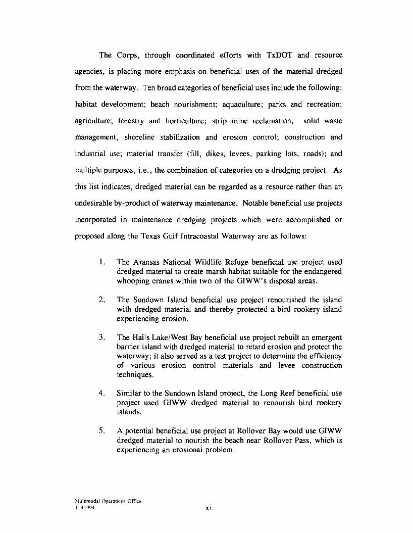
1. The Aransas National Wildlife Refuge beneficial use project used dredged material to create marsh habitat suitable for the endangered whooping cranes within two of the GIWW' s disposal areas.
2. The Sundown Island beneficial use project renourished the island with dredged material and thereby protected a bird rookery island
. . . expenencmg erosion.
3. The Halls Lake/West Bay beneficial use project rebuilt an emergent barrier island with dredged material to retard erosion and protect the waterway; it also served as a test project to determine the efficiency of various erosion control materials and levee construction techniques.
4. Similar to t_he Sundown Island project, the Long Reef beneficial use project used GIWW dredged material to renourish bird rookery islands.
5. A potential beneficial use project at Rollover Bay would use GIWW dredged material to nourish the beach near Rollover Pass, which is experiencing an erosional problem.
Multimodal Operations Office JLRl994 Xl
During fiscal years 1993-1994, TxDOT completed the acquisition process
(see Appendix A) for two upland dredged material placement sites in Matagorda
County. Although the Texas Transportation Commission authorized the
acquisition of these two sites several years ago, in 1988, lengthy title clearance
and condemnation proceedings delayed the fee title acquisition. Easements on
these sites, as well as a third Aransas County site acquired in fiscal year 1992,
should be conveyed to the Corps in fiscal year 1995. Acquisition of a Galveston
County site should also be completed in fiscal year 1995. Each of these sites will
provide a minimum of thirty years' upland storage capacity.
The Mexican state of Tamaulipas is actively pursuing the extension of the
GIWW into Mexico; TxOOT' s International Relations Office and Multi modal
Operations Office will be available for this and other challenges involving the
North American Free Trade Agreement (NAFTA).
To support the state's nonfederal sponsorship of the GIWW in Texas and
facilitate planning, maintenance, preservation, research, and improvement of the
waterway, the following are recommended for consideration by the Texas
Legislature:
The state continue to recognize and promote the Gulf Intracoastal Waterway as an integral and valuable part of the state's multimodal transportation system.
The state provide the authority for the participation and funding to support the Gulf Intracoastal Waterway's projects using dredged material for beneficial purposes.
The state advocate the continuation of the U.S. Army Corps of Engineers' Section 216 Studies, which will address the physical and/or economical changes of the Gulf Intracoastal Waterway in Texas.
Multimodal Operations Office JLR1994 XU

PREFACE

!!!!!!!!!!!!!!!!!!!"#$%!&'()!*)&+',)%!'-!$-.)-.$/-'++0!1+'-2!&'()!$-!.#)!/*$($-'+3!
44!5"6!7$1*'*0!8$($.$9'.$/-!")':!
PREFACE
Prior to 1975, the Gulf Intracoastal Waterway (GIWW) in Texas had no
single local nonfederal sponsor. Various navigation districts, river authorities, and
port authorities located along the GIWW attempted to coordinate local
management efforts with those of the federal sponsor, the United States Army
Corps of Engineers (Corps).
In 1975, the state legislature passed the Texas Coastal Waterway Act.
This act authorized the State of Texas to act as local nonfederal sponsor for the
GIWW in Texas and designated the State Highway and Public Transportation
Commission, now the Texas Transportation Commission, to act as agent for the
state in fulfilling the responsibilities of the nonfederal sponsor. (See Appendix C.)
The nonfederal sponsor works closely with the Corps to provide local
cooperation and input into federal projects. Local sponsorship requirements may
vary as different projects are authorized by the United States Congress. It is
usually the responsibility of the nonfederal sponsor to provide all land needed for
construction and maintenance of a project at no cost to the federal government.
Many projects also require that the local sponsor make any necessary alterations
to pipelines, cables, and other utilities which may be located in the project area.
The local sponsor also may be required to construct and/or maintain containment
facilities for dredged material. Whatever the particular requirements may be of
the local nonfederal sponsor, it is a general requirement that the federal
government be held free from any damage that might result from construction and
maintenance of the project. In the case of state sponsorship, this requirement can
be fulfilled only to the extent permitted by state law.
Multimodal Operations Office JLR1994 xv
In addition to serving as the nonfederal sponsor of the GIWW, the Texas
Coastal Waterway Act mandated the Texas Transportation Commission to carry
out the coastal policy of the State of Texas. (See Appendix C.) The state has
declared its support of the shallow-draft navigation of the state's coastal waterway
in an environmentally sound fashion and will strive to prevent the waste of both
publicly and privately owned natural resources while preventing or minimizing
adverse impacts to the environment. The state has also pledged itself to
maintaining, preserving, and enhancing wildlife and fisheries. Much of the state's
coastal policy emphasizes the importance of protecting the environment, while at
the same time supporting navigation functions.
To carry out the mandate and to further discharge the duties of the
nonfederal sponsor, the commission was instructed to continually evaluate the
GIWW as it relates to Texas. Such an evaluation involves the consideration of
both tangible and intangible values. If the state is to prevent the waste of its
coastal resources and minimize adverse environmental impacts while
simultaneously fostering an efficient system of navigation, it is first necessary to
identify existing conditions and needs. This report, the tenth in the series as
required by the act, is submitted to the Seventy-fourth Legislature to assist in
achieving the full potential of the GIWW while protecting coastal resources.
Multimodal Operations Office JLRl994 XVl
Chapter One
THE TEXAS WATERWAY STORY
THE TEXAS WATERWAY STORY
Introduction
The Gulf Intracoastal Waterway (GIWW) parallels the Gulf of Mexico's
coastline from Brownsville, at the southernmost tip of Texas, to St. Marks,
Florida. This man-made channel, authorized by the United States Congress, is
maintained by the U. S. Army Corps of Engineers (Corps) at a bottom width of
one hundred twenty-five feet and a minimum depth of twelve feet. Because it is
less than twenty-five feet deep, the waterway is defined as a shallow-draft canal.
Nevertheless, it capably carries a large variety and a great number of vessels and
tons. The GIWW is an integral part of the total inland transportation system of
the United States, which also includes the Atlantic Coast, Mississippi River and
Antilles, Great Lakes, Pacific Coast, Alaskan, and Hawaiian waterway systems.
The GIWW is a vital link in the transportation network that moves many of the
commodities called for by this nation, as well as foreign markets.
Development of the Gulf Intracoastal Waterway in Texas
The first beginnings of an inland waterway transportation system in Texas
came in 1850, just five years after Texas was admitted to the Union. Local
business interests, who pioneered inland navigation in Texas, connected portions
of the state's coastline by dredging links between the natural bays, lakes, rivers,
and bayous. The construction of Texas' first navigable segment of the GIWW,
the Galveston and Brazos Canal, was completed around 1853. This canal's depth
ranged from three to six feet and connected West Galveston Bay and the Brazos
River.
Multimodal Operations Office JLR1994

The first federal step toward construction of a continuous marme
transportation system west of the Mississippi River was the Rivers and Harbors
Act of 1873. This act appropriated funds for a survey to "connect the inland
waters along the margin of the Gulf of Mexico from Donaldsonville, Louisiana,
to the Rio Grande River in Texas by cuts and canals. "1
The expansion of the inland system throughout the coastline of Texas was
not accomplished in one effort. A series of congressional acts passed between
1925 and 1942 allowed the gradual extension of the waterway (see Appendix B).
By 1941, the GIWW in Texas extended from the Sabine River to Corpus Christi
and was 100 feet wide by 9 feet deep. Improvement of the canal to its current
status was authorized by legislation passed in 1942; construction was completed
by 1949. The result was an extended route from the Sabine River to Brownsville,
Texas, with the new dimensions of 125 feet wide by 12 feet deep. Figure 1
depicts the GIWW in Texas.
The Pmh of the Wmerway
The length of the GIWW in Texas is 423 miles2 and a variety of sights are
encountered along the way. Dunes, flats, fishing cabins, bays, rivers and streams,
farm and ranch lands, wetlands, wildlife and marine life, parks, refuges, and
historic landmarks: all can be seen from the canal. Other frequently seen
features along the waterway include industrial, recreational, and residential
developments.
1Rivers and Harbors Act of 1873, "House Document 1491, 62nd Congress," Volume 1.
2Mileage of the Gulf Intracoastal Waterway in Texas, as reported by the Galveston District, U.S. Army Corps of Engineers.
Muhimodal Operations Office JLR1994 2

MAIN CHANNEL GULF INTRACOASTAL WATERWAY
IN TEXAS
o'<-
N
WILLACY
FIGURE 1
The path of the waterway is etched through many shallow bays that lie on
the landward side of the natural barrier islands which protect most of the Texas
coastline. This inward course gives the waterway its inland classification. Many
creeks and streams empty into the GIWW, but only two major rivers flow directly
into it on their way to the Gulf of Mexico. These rivers, the Colorado and the
Brazos, have currents strong enough to require protective flood control gates for
the waterway during high-water stages.
The route of the G IWW leads through some of the most biologically
productive, yet sensitive, areas of the Texas coast. These wetland areas are widely
recognized as the nurseries for many species of finfish and shellfish, so valuable
to the commercial and recreational industries. The environmentally delicate
wetlands are also the nesting or feeding grounds for vast numbers of waterfowl,
mammals, and reptiles. Native wetland vegetation is an important ecological
contribution to the coastal system, providing sustenance for the animal inhabitants
and retarding erosion by holding onto the unstable soil that is common among
coastal regions. Much has been learned in recent years about the importance of
maintaining a balanced relationship between the delicate nature of wetlands and
the effects on them from water management projects. As a result, there are many
state and federal regulations administered to protect the fragile wetlands and the
coastal environment.
A Busy Transportation Artery
One of the initial functions of the GIWW was to provide protected inland
transportation of goods and troops during World War II. It has since evolved into
a multipurpose waterway with a wide assortment of users. Today, many
individuals largely associate the GIWW with recreation. Sport fishing and boating
Muhimodal Operations Office JLRl994 4
are very popular along the Texas coast, and many recreational facilities have been
established on or near the waterway. However, it is the commercial trade link
that the waterway provides, and the subsequent economic prosperity for the Texas
coastal region and the state as a whole, that accounts for much of the waterway's
value.
Many industries have concentrated in the coastal region of Texas to
capitalize on the economic benefits of water transportation efficiency. Thousands
of jobs are directly and indirectly linked to the waterway, and almost 75 % of all
goods shipped in Texas are moved by water. 3 In fact, in 1992, Texas was second
nationally only to Louisiana in the amount of goods shipped by water. 4 The
transfer of goods by water is second only to pipelines in cost efficiency, but is not
limited by specialization as pipelines are. 5 Commercial trade between Texas ports
and other port centers of the United States, as well as foreign trade markets, is
greatly facilitated by the GIWW. The waterway is directly linked with Texas'
twelve deep-draft port channels, and it greatly increases the level of access and
level of service to many tributaries and private channels. The deep-draft port
channels in Texas are Sabine Pass Harbor, Port Arthur Canal, Beaumont, Orange,
Galveston Ship Channel, Houston Ship Channel, Texas City Channel, Freeport
Ship Channel, Matagorda Ship Channel, Corpus Christi Ship Channel, Port Isabel
Ship Channel, and Brownsville Ship Channel.
3Sea Grant Program, Texas A & M University. Primary Economic Impact of the Gulf lntracoasta.1 Waterway in Texas. College Station, Texas, 1974, p. 128.
4U. S. Army Corps of Engineers. MY-CG Reeion Freiibt Traffic Tables CY 1992 - Advanced Information. Part 2, 1992.
5State Department of Highways and Public Transportation, The Gulf Intracoastal Waterway in Texas, 1976. p. 8.
Multimodal Operations Office JLR1994 5
The GIWW is most effectively used by barge traffic, and according to the
latest available waterborne commerce statistics compiled by the Corps, an annual
average of 72.5 million tons of goods has been barged along the Texas GIWW
between 1982 and 1992. Petroleum products, chemicals, and crude petroleum
accounted for approximately 86 % of the 1992 tonnage moved on the waterway.
Other bulk materials such as minerals, metals, grains, shell, and miscellaneous
materials accounted for the remaining annual percentage.
Commercial fishing boats and boats associated with the oil and gas drilling
industry in the Gulf of Mexico utilize the waterway, as well as recreational
boaters. Not only is the GIWW used as a reliable transportation corridor between
coastal regions, but it is also used for skiing, fishing, and sightseeing. For
smaller and less seaworthy vessels, the waterway offers protected passage from
the stormy Gulf of Mexico, and moorings are located periodically along the canal
for those who may need them. Larger vessels use the waterway because it has
sufficient depth for their deeper draft hulls.
Recreational use of the waterway was researched in 1980. By conducting
a random survey ofrecreational boat owners in Texas, it was determined that 2.4
million recreational boat trips originated in Texas coastal waters annually. 6 The
survey also revealed that I. 9 million, or 79% of the total 2.4 million recreational
trips, utilized the GIWW. (These trip figures are used to describe the total
number of trips made by each boat. If one boat is put into coastal waters ten
times in a year, it would equal ten trips annually.) Over 65 % of the recreationists
surveyed reportedly used the GIWW as a major thoroughfare between coastal
6State Department of Highways and Public Transportation, The Gulf Intracoastal Waterway in Texas, 1982.
Multimodal Operations Office JLRI994 6
bays, and most of the trip lengths on the waterway were between 5 and 50 miles
each.
Overview of 1992
In 1992, 76. 7 million short tons (one short ton equals 2,000 pounds) of
goods moved on the Texas Gulf Intracoastal Waterway. The estimated value of
those goods, transported in a safe, efficient, and economic manner, amounted to
22.2 billion dollars. 7 Texas handled 68% of the 1992 total short tons moved on
the waterway between Brownsville, Texas and St. Marks, Florida. The Corps
compiles tonnage statistics8 and also provides estimates for evaluating the
commercial impact of the waterway. Revised estimates for the average number
of tons per barge show that it would require approximately 35,674 barges to move
the 76.7 million tons in Texas during 1992. If the same volume of goods were
moved via railroad transportation, approximately 535,110 railroad carloads would
have been required. If moved via truck transportation on the state highway
system, it would have required 2,140,440 semitrailer truckloads, resulting in
considerable wear and tear on the roadway surfaces. 9 Safe transportation of
7Texas Transportation Institute, Policy and Management Division, Texas A & M University System, College Station, Texas. 1992 values determined by updating a 1982 Data Resources, Inc. Study for the U. S. Army Corps of Engineers. (See Bibliography.)
8U. S. Army Corps of Engineers. Waterborne Commerce of the United States, Part 5, 1992, and MV-CG Reiion Freiaht Traffic Tables, CY 1992 -Advanced Information. Part 2, 1992.
9 Average estimated number of tons per barge (2,150) was provided by the Galveston District Corps of Engineers, Economic and Social Analysis Branch. 1990. Translations from barges to railroad cars and semitrailer trucks given by Kelly, Brigadier General Patrick, U. S. Army Corps of Engineers. Speech. Presented at the meeting of the American military engineers in Houston, Texas, September 22, 1988.
Multimodal Operations Office JLR1994 7
barged materials, many of which are hazardous, is recorded in Table 2-23 of the
U. S. Office of Technology Assessment's 1986 report, "Transportation of
Hazardous Materials." For the period from 1976 to 1984, the total number of
documented, hazardous spills in Texas included 48 by air transportation, 2,854 by
truck; 1,265 by rail; 6 by water transportation; and 18 by other modes.
In addition to facilitating commercial goods movements and serving
recreational boaters, the GIWW also provides access to the prime fishing areas for
the commercial industry and sport fishing boats. This group produced a 1992
catch of 85.8 million pounds of shrimp, oysters, crabs, and finfish amounting to
an ex-vessel value (value received at wholesaler's dock) exceeding 157 .5 million
dollars. 10
Conclusion
The early settlers of Texas colonized natural water routes because they
knew that a close proximity to water transportation would bring many advantages.
Since the dredging of Texas' first segment, the waterway's service, value, and
subsequent effect on economic prosperity have grown significantly. The GIWW,
which is extensively used by a wide variety of people, imparts many benefits both
directly and indirectly to the state and the nation, thereby accounting for the
wisdom of protecting and maintaining this important transportation mode.
1°Texas Parks and Wildlife Department, Trends in Texas Commercial Fishery Landin~s. 1977-1993,
Multimodal Operations Office JLRl994 8
Chapter Two
THE LAGUNA MADRE

!!!!!!!!!!!!!!!!!!!"#$%!&'()!*)&+',)%!'-!$-.)-.$/-'++0!1+'-2!&'()!$-!.#)!/*$($-'+3!
44!5"6!7$1*'*0!8$($.$9'.$/-!")':!
THE LAGUNA MADRE
The Laguna Madre is a long, partially enclosed body of saltwater which
reaches from Corpus Christi, Texas south along the coastline to the Mexican
border. It is one of only three biologically productive hypersaline lagoons in the
world. Although its average depth is only three to five feet, the Laguna Madre
is nevertheless one of the most productive fisheries along the Texas coast.
Recognized for its abundant flora and fauna, the Laguna Madre holds a special
attraction for those who appreciate its many natural features.
The Gulf Intracoastal Waterway (GIWW) extends south through the
Laguna Madre to Port Isabel, where it intersects the Brownsville Ship Channel.
To facilitate the GIWW' s original construction from Corpus Christi to Port Isabel,
the state of Texas granted right of way easements for both the channel and
disposal areas for placement of the project's dredged material. Many of the
designated disposal areas used in maintenance of the waterway lie in the open
waters of the Laguna Madre. Some of the disposal areas are emergent (that is,
they extend above the waterline); others are completely submerged.
The GIWW in South Texas is an important transportation link used by
commercial, recreational, and shipping interests. It connects this southern region
of the state not only with other gulf states, but also with the Mississippi River and
tributary systems. In addition, increased inland waterway commerce is expected
as a result of the North American Free Trade Agreement (NAFTA).
The Laguna Madre and the GIWW are of significant importance to many
diverse groups, for equally diverse reasons. Environmental groups have expressed
concerns over the impact of open-water dredged material disposal within the
unique and prolific Laguna Madre, to the extent of coordinating efforts toward the
Multimodal Operations Office JLR1994 11
possible closure of the GIWW there. Transportation interests have responded by
emphasizing the importance of the GIWW to the regional economy and its benefits
to the environment. While it is a challenge for the GIWW and the Laguna Madre
to coexist, it is important that concerned interests strive through teamwork to
achieve this goal.
.This chapter isa condensed chronology of the events involving the Laguna
Madre and the GIWW during 1993-1994. These events have claimed much
attention, stressing the need to address waterway issues in new and innovative
ways. Dedicated efforts are currently underway to explore new methods to
maintain the navigation channel through the lagoon, while simultaneously fostering
the protection and enhancement of the coastal environment.
Upper Laguna Madre
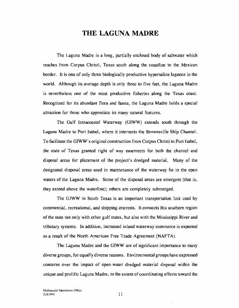
In May 1993, the Texas Department of Transportation (TxDOT)
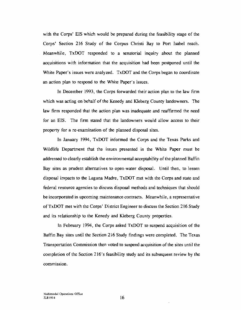
accelerated efforts to acquire 750 acres near Baffin Bay, in the upper Laguna
Madre area. (See Figure 2.) This acreage, located in Kleberg and Kenedy
Counties, would provide four upland disposal sites with sufficient capacity for at
least thirty years of routine GIWW maintenance; longer, if the sites were
recycled. These upland alternatives to traditional open-bay disposal sites were
approved by the U.S. Army Corps of Engineers (Corps) through an
Environmental Assessment and Finding of No Significant Impact (EA-FONSI).
In July 1993, the Corps initiated the twelve-month reconnaissance phase
of a Section 216 Study (see Appendix B). Authorized by the Federal Flood
Control Act of 1970, this study would evaluate the GIWW's physical and/or
economic changes for the reach between Corpus Christi Bay and Port Isabel,
Texas. If the reconnaissance study determined significant changes, as well as
:..lultimodal Operations O!lice JLRl994 12

'Tl G)
C ::;u m N
\ . \
'. BAFFIN \ ' \
\ . \
,,,,,,.----4-B7-
KENEDY COUNTY \ \_ \ KLEBERG COUNTY
'. BAY \
OINT ' ENASCA~ §
' . - - - - .. - - - _q_UJ-E • - ! - _, __ ~913- - J __ \lNI~~~IeL~- - -- --~
+ t i.a... -------------- --- - - - - - - - - - • - • • • - - - - - - - - sa: - L 191 I - - _.... - - - · § I 199 I ~ \ § .. - - _ : - - • _ ~ ~ • ~-- --- 193 . e , . ~ .. - -• .. -·- ..
g \ ~ ~- - : : : : : -f- ... W41;
• DESIGNATES AREA TO BE ACOURED
PADRE
D EXISTING OPEN WATER DISPOSAL SITES
• ~-- ... £~Ar NA ~-- ... _,., , LAGU _--....._ ~=: :~- --_ ~ ---.......... ~ g·- -
MADR£ ~ - - -\ . \
ISLAND \ NATIONAL SEASHORE ' \ . ~ . I
I . GULF I .
I . I
OF MEXICO
LAGUNA MADRE/BAFFIN BAY AREA
0 I 2 SCALE j I I MILES
TEXAS DEPARTMENT OF TRANSPORTATION
identified a federal interest in proceeding with further evaluations, the study
process would proceed to the four-year feasibility phase. A feasibility study
would consist of detailed engineering, economic, and environmental studies to find
the most cost-effective solution for the identified problems while protecting the
environment. In addition, the feasibility study would include the preparation of
an environmental document and long-term disposal plan for the GIWW's Corpus
Christi Bay to Port Isabel reach.
In August 1993, the Kleberg County landowner of the three upland sites
proposed for acquisition wrote the Secretary of the Interior and the Secretary of
Commerce, alleging violation of the Endangered Species Act. Also set forth in
that letter was the landowner's intent to commence a civil suit to prohibit any use
of the properties for disposal operations.
In September, a law firm acting on behalf of both the Kleberg and Kenedy
County landowners presented a 'White Paper' to the Corps and furnished a copy
to TxDOT as well. The 'White Paper' challenged the Corps' EA/FONS I for the
use of the four upland sites as GIWW dredged material disposal areas. In
addition, the paper challenged the consideration of other alternative disposal
solutions for the Baffin Bay region.
One of the landowners issued a press release in October 1993, urging the
Corps to prepare an Environmental Impact Statement (EIS) and that TxDOT
suspend all plans to condemn the four sites for disposal use. While it was
unnecessary for TxDOT to suspend condemnation plans, as the agency had not
initiated condemnation proceedings, the negotiating phase of acquisition was
postponed. TxDOT then transmitted copies of the 'White Paper' to members of
the Gulf Intracoastal Waterway Advisory Committee (GIWAC) (see Table 1) and
Multimodal Operations Office JLR1994 14
its task force representatives. (The GIW AC task force is composed of
representatives from GIW AC, federal resource agencies, and the Corps.)
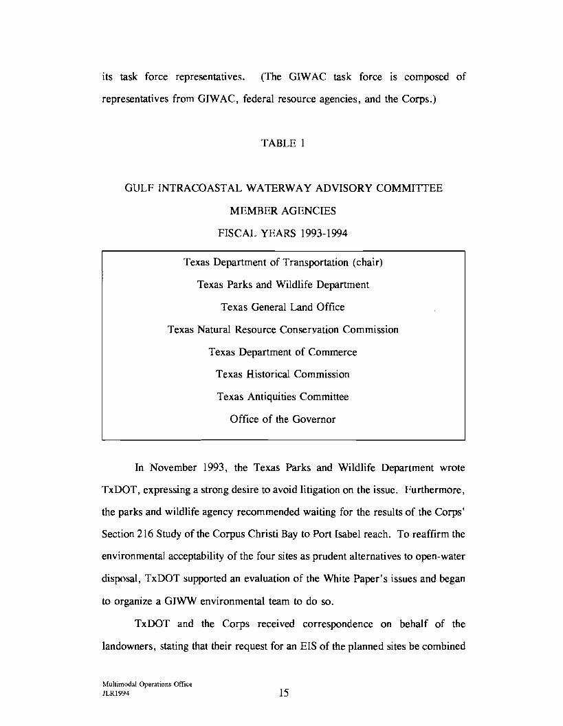
TABLE 1
GULF INTRACOASTAL WATERWAY ADVISORY COMMITTEE
MEMBER AGENCIES
FISCAL YEARS 1993-1994
Texas Department of Transportation (chair)
Texas Parks and Wildlife Department
Texas General Land Office
Texas Natural Resource Conservation Commission
Texas Department of Commerce
Texas Historical Commission
Texas Antiquities Committee
Office of the Governor
In November 1993, the Texas Parks and Wildlife Department wrote
TxDOT, expressing a strong desire to avoid litigation on the issue. Furthermore,
the parks and wildlife agency recommended waiting for the results of the Corps'
Section 216 Study of the Corpus Christi Bay to Port Isabel reach. To reaffirm the
environmental acceptability of the four sites as prudent alternatives to open-water
disposal, TxDOT supported an evaluation of the White Paper's issues and began
to organize a GIWW environmental team to do so.
TxDOT and the Corps received correspondence on behalf of the
landowners, stating that their request for an EIS of the planned sites be combined
Multimodal Operations Office JLR1994 15
with the Corps' EIS which would be prepared during the feasibility stage of the
Corps' Section 216 Study of the Corpus Christi Bay to Port Isabel reach.
Meanwhile, TxDOT responded to a senatorial inquiry about the planned
acquisitions with information that the acquisition had been postponed until the
White Paper's issues were analyzed. TxDOT and the Corps began to coordinate
an action plan to respond to the White Paper's issues.
In December 1993, the Corps forwarded their action plan to the law firm
which was acting on behalf of the Kenedy and Kleberg County landowners. The
law firm responded that the action plan was inadequate and reaffirmed the need
for an EIS. The firm stated that the landowners would allow access to their
property for a re-examination of the planned disposal sites.
In January 1994, TxDOT informed the Corps and the Texas Parks and
Wildlife Department that the issues presented in the White Paper must be
addressed to clearly establish the environmental acceptability of the planned Baffin
Bay sites as prudent alternatives to open-water disposal. Until then, to lessen
disposal impacts to the Laguna Madre, TxDOT met with the Corps and state and
federal resource agencies to discuss disposal methods and techniques that should
be incorporated in upcoming maintenance contracts. Meanwhile, a representative
of TxDOT met with the Corps' District Engineer to discuss the Section 216 Study
and its relationship to the Kenedy and Kleberg County properties.
In February 1994, the Corps asked TxDOT to suspend acquisition of the
Baffin Bay sites until the Section 216 Study findings were completed. The Texas
Transportation Commission then voted to suspend acquisition of the sites until the
completion of the Section 216's feasibility study and its subsequent review by the
comm1ss1on.
Multirnodal Operations Office JLR1994 16
With the suspension of the Baffin Bay acquisitions and resulting lack of
alternative upland disposal sites in the area, the aim to minimize open-water
disposal practices remains problematic. Until federal studies identify disposal
solutions, GIWW maintenance projects will continue with traditional open-water
sites in this region of the upper Laguna Madre, minimizing impacts where
possible with beneficial uses of dredged material or other project modifications,
such as localized placement areas.
Lower Laguna Madre
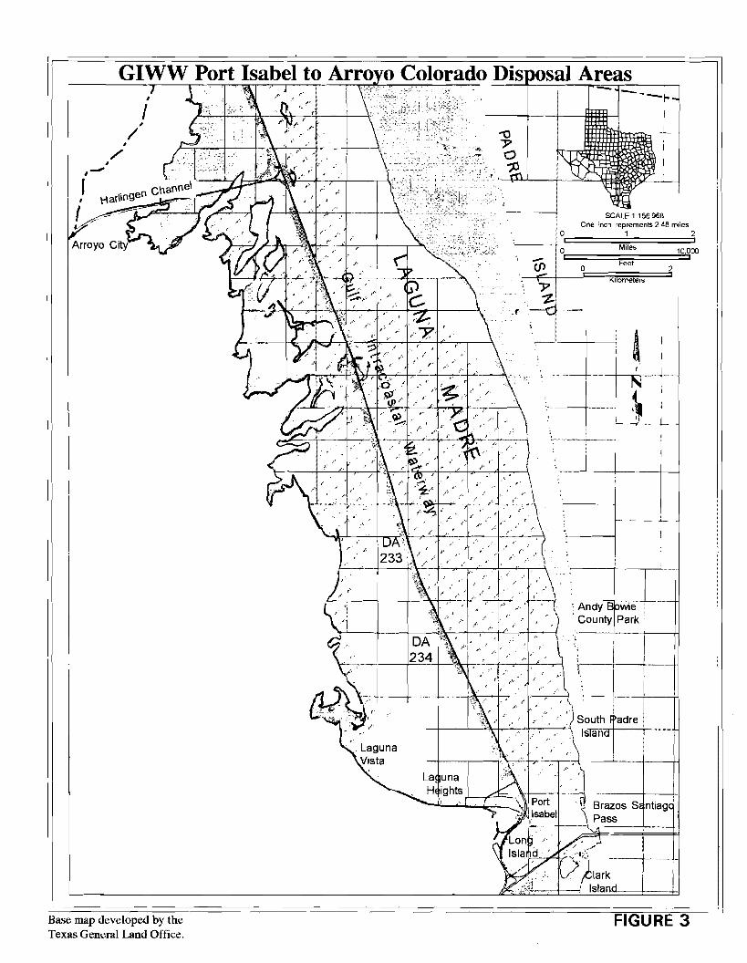
In January 1994, the Corps issued an invitation for bids to private dredging
contractors to maintain a segment of the GIWW in the lower Laguna Madre. The
dredging operation identified the GIWW segment as the Port Isabel to Arroyo
Colorado maintenance project. A 29 ,000-foot stretch just north of Port Isabel and
a 5,000-foot segment of the GIWW turning wye at the Channel to Harlingen
required maintenance dredging, as well as the U.S. Coast Guard Channel and
Basin in Cameron County, Texas.
For the 29,000-foot stretch just north of Port Isabel, dredged material
would be placed within the Corps' authorized open-water disposal areas, DA233
and DA234, indicated on Figure 3. This part of the project called for the removal
of approximately 756,000 cubic yards of dredged material.
The Port Isabel to Arroyo Colorado maintenance project generated
concerns about environmental impacts related to open-water disposal. The clash
between pro-bay and pro-waterway interests resulted in an evolution of the
coordination of maintenance projects in the environmentally sensitive Laguna
Madre. Many factors contributed to this process: environmental groups became
increasingly active; the Governor personally requested protection of the Laguna
Multimodal Operations Office JLR1994 17
GIWW Port Isabel to Arro o Colorado Dis osal Areas
• ,-J
I
/
Base map developed by the Texas General Land Office.
Launa
j I I ~1 i :,'.·~j--... _.:..
H ights ~--.,e.-..... -
I
_L
SCALE 1 156 968
I -,~--+---+
·,. /_~
FIGURE 3
Madre, while strongly supporting the continuance of the GIWW through it; state
and federal resource protection agencies assumed stronger positions; transportation
and commercial interests entered into the information-gathering process; a lawsuit
was filed; and the Corps initiated a new partnering approach to maintenance
project coordination.
In February 1994, the Corps amended its invitation for bids on the Port
Isabel to Arroyo Colorado maintenance project. In an effort to ease concerns over
open-water disposal, the amendment called for reducing the dredge pump size,
plus downsizing the disposal pipe to 18 inches. These adjustments would allow
for better management during the dredged material placement operation.
Additionally, the Corps modified the dredging schedule to avoid interference with
bird nesting seasons in Disposal Area 233. A third change in the bid package
included the inclusion of two sites within designated Disposal Area 234 to provide
for a study of dredged material impacts on seagrasses. If the seagrasses
responded favorably to transplanting onto dredged material, future placement of
dredged material could be beneficially applied to other maintenance projects.
In March 1994, the Governor of Texas wrote to the Corps' Southwestern
Division Commander in Fort Worth, Texas, and the District Engineer in
Galveston, Texas, concerning GIWW maintenance dredging in the Laguna Madre.
The Governor expressed deep concern for the impacts of open-water, unconfined
disposal, but also strongly supported the continued operation of the GIWW
between Corpus Christi and the lower Rio Grande Valley. The Governor
requested the Corps to expedite the EIS process and strongly urged the Corps to
consider gulf disposal for projects in the Laguna Madre. In addition, the
Governor asked the Corps to work with the Texas Parks and Wildlife Department
Multimodal Operations Office JLR1994 19
and other interested parties to develop an interim plan to protect the Laguna
Madre.
Also in March, the Corps temporarily postponed the invitation for bids on
the GIWW's Port Isabel to Arroyo Colorado maintenance project and contacted
TxDOT, the nonfederal sponsor. The Corps requested assistance from TxDOT,
GIW AC, and the GIWAC task force. The goal was to develop affordable and
environmentally acceptable interim disposal options for the Port Isabel to Arroyo
Colorado project until such time as the Section 216 Study for the Corpus Christi
Bay to Port Isabel reach would be completed.
Later in March, the Corps responded to the Governor's letter, explaining
the difficulty of expediting the EIS process. Because the process relied heavily
on the development of data obtained through the reconnaissance phase of the
Section 216 Study, the preparations of an EIS could not be committed to a firm
schedule until the reconnaissance study was completed. In addition, the Corps
informed the Governor of the previous coordination with the Texas Parks and
Wildlife Department and other state and federal agencies on modifying dredging
projects to accommodate environmental concerns. The Corps also reported the
following to the Governor: the National Audubon Society's request to augment
eroding bird islands with material dredged in the Port Isabel to Arroyo Colorado
project; the Corps' intention to coordinate with GIWAC; and the anticipated cost
to the state and probable impacts should disposal switch to the gulf.
At the end of March 1994, the Corps informed the National Audubon
Society of its intention to accomplish environmental coordination through GIWAC.
Furthermore, because of Audubon's management authority over some of the bird
islands in the Port Isabel to Arroyo Colorado reach, a local Audubon
representative would be included on the GIW AC task force.
Multimodal Operations Office JLRI 994 20
In April 1994, dredged material spilled into the Laguna Madre from an
upland disposal site for the Port Mansfield Channel. Although not directly related
to the GIWW, the spill intensified negative feelings about dredging and disposal
operations in the Laguna Madre area. In addition, the Texas Center for Policy
Studies released its report in April, "Subsidized Destruction: The Gulf
Intracoastal Waterway and the Laguna Madre," further intensifying concerns about
the GIWW through the Laguna Madre.
Also during April, the Corps indefinitely postponed the bidding process for
the Port Isabel to Arroyo Colorado maintenance project. TxDOT informed the
Governor's Office that the GIW AC task force would soon begin work on
identifying affordable and environmentally acceptable interim disposal options for
the project. The task force would present its findings to the April 15, 1994
GIWAC meeting. At the request of the Governor's Office, a member of the
Texas Coastal Coordination Council was included on the task force to represent
environmental concerns about the project. To promote a balance of interests in
the task force effort, TxDOT expanded the effort to include certain organizations
as corollary invitees.
The corollary invitees to the GIWAC task force included representatives
from the Texas Coastal Coordination Council, the National Audubon Society, the
Atascosca National Wildlife Refuge, Padre Island National Seashore, and the
inland transportation industry. As an added effort, TxDOT also coordinated the
task force's work with other public and private entities. Schedule conflicts
precluded the GIWAC task force meeting and planned April 15, 1994 report to
the GIWAC members. The April GIWAC meeting was used instead to direct the
task force's efforts. A May 3-4, 1994 task force meeting was set for Harlingen,
Texas.
Multimodal Operations Office JLRl994 21
The May 3-4 task force meeting, which was aided by a contract facilitator,
allowed the state and federal agencies, private, environmental, and transportation
industry representatives to discuss field observations, identify concerns, and
develop ideas for alternative disposal methods in the lower Laguna Madre. The
task force's preferred method of dredged material disposal was upland disposal
utilizing the nearest available contained sites; however, other alternatives were
also recommended. One alternative included the containment of dredged material
in unvegetated sections of the existing open-water disposal areas by utilizing
geotextile tubes to construct emergent islands. Also recommended was
minimizing the volume of materials by dredging only the sections currently 12'
deep or less to a depth of 12' plus l' maximum allowable overdredge.
On May 10, the Texas Waterway Operators Association passed two
resolutions. The first recommended that: 1) the Corps continue the temporary
moratorium on open-water dredged material disposal in the Laguna Madre until
September 1994; 2) all interested parties should develop studies on the
environmental effects and costs of disposal options; and 3) in the event of
imminent danger to continued navigation on the GIWW, the temporary
moratorium should be lifted immediately. The second resolution requested that
GIW AC: 1) withhold any disposal recommendations for the Laguna Madre during
the extended, temporary moratorium; 2) complete further studies, and 3) meet
jointly with interested parties before September 1994.
In response, the Corps then moved to defer dredging in the Laguna Madre
until September with one provision: the Corps was obligated to maintain the
GIWW's congressionally authorized depth to assure safe, unimpeded navigation.
Should such navigation be challenged, the Corps would have to proceed with
dredging.
Multimodal Operations Office JLRI994 22
The May 13, 1994 GIW AC meeting resulted in a resolution of their own
that the task force: 1) continue efforts during the extended, temporary
moratorium; 2) develop recommendations for preferred disposal options; and 3)
present final recommendations to GIWAC on July 1, 1994.
The task force continued its efforts in June 1994, reviewing a recent three
day seagrass survey in the vicinity of Disposal Areas 233 and 234. Later that
month, the task force met with a representative from the National Audubon
Society to consider all the available information. For the immediate project, the
task force conceded that, under the existing constraints of time and economic,
environmental, and operational considerations, some open-water disposal must
continue in unvegetated portions of existing disposal areas. The task force also
recommended extensive monitoring of various open-water methods to provide
substantive input to the Section 216 Study process. The task force supported the
Corps' Section 1135 seagrass enhancement study for research purposes;
eliminated bird island augmentation as an option m the project reach;
recommended that options, costs, and environmental impacts be reported to
GIW AC; and requested further postponement of dredging.
The task force presented its findings to the GIW AC members on
July 1, 1994. The committee then developed a prioritized list of recommended
disposal options, which TxDOT sent to the Corps on behalf of GIW AC. In a July
1994 letter to the Corps, the Governor endorsed GIWAC's recommendations and
reaffirmed the position of supporting the continued operation of the waterway,
while preserving the coastal environment.
Also in July, the Corps presented its disposal plan to the Governor's Office
in a meeting that included representatives from TxDOT and the Texas Parks and
Wildlife Department. TxDOT forwarded the disposal plan, which included
Multimodal Operations Office JLR1994 23
monitoring and studying disposal impacts, to the GIW AC members not present
at the Governor's meeting. The Corps later revised the disposal plan to reduce
the volume of dredged material as much as possible and still conduct a meaningful
study of the maintenance dredging project's impact. The Corps then proceeded
to develop plans and specifications in order to begin dredging in September 1994,
immediately after the Laguna Madre dredging moratorium ended.
The Corps awarded the dredging contract for the Port Isabel to Arroyo
Colorado maintenance dredging in August 1994. Additional developments in
August included the Texas Parks and Wildlife Department's application for a grant
to obtain additional funds for the Port Isabel to Arroyo Colorado maintenance
project. In addition, the Texas Parks and Wildlife Department hosted a meeting
in Harlingen to evaluate what additional dredged material could be contained for
the pending project, if additional funds were available from the state. The grant,
however, was not awarded, because characteristics of the project's application did
not conform to the grant's criteria.
Also in August, TxDOT wrote the Corps, supporting the creation of an
Interagency Coordination Team (ICT) for the Corpus Christi Bay to Port Isabel
segment of the GIWW. Operated as a joint effort and sponsored by the Corps,
the purpose of the ICT was to improve coordination between agencies and
environmental interests while studying environmental concerns and issues related
to the Laguna Madre. The JCT would develop scopes of work necessary for
studies to gather valuable information that can be applied to the establishment of
a dredged material management plan. Later in August, the Corps hosted a
partnering session with contractors, the local nonfederal sponsor, and natural
resource agencies for the Port Isabel to Arroyo Colorado maintenance project.
:--.lultimodal Operations Office JLR1994 24
In addition, the Corps hosted a helicopter survey of the Laguna Madre for an
aerial view of all the concerned areas.
On September 2, 1994, the National Audubon Society, in conjunction with
six local environmental organizations, filed a lawsuit against the Corps. The
plaintiffs were seeking an injunction to stop what they regarded as environmentally
destructive disposal practices in the Corpus Christi Bay to Port Isabel reach of the
Laguna Madre. After a week-long trial and based on the available evidence and
testimony, the judge ruled to deny the plaintiffs' request.
The Corps subsequently continued with dredging, which had not been
interrupted during the court session, in accordance with the designed plans and the
issued contract. The dredging plans, which were consistent with those presented
by the Corps at the Governor's office on July 22, 1994, included the following:
extensive seagrass planting; various methods of sediment control and monitoring
thereof; turbidity studies; and maximum collaboration with environmental agencies
on issues critical to the overall health of the Laguna Madre. Historic dredging
and disposal practices would also be monitored to determine the impact of open
water placement. In addition, the Corps complied with TxDOT' s request to defer
dredging over 100,000 cubic yards for the Port Isabel to Arroyo Colorado
maintenance project. This project's plan would gather valuable information which
may be applicable to the next maintenance project in this reach and facilitate
efforts to avoid or minimize adverse environmental impacts, while providing for
safe, unimpeded navigation.
Multimodal Operations Office JLR1994 25

!!!!!!!!!!!!!!!!!!!"#$%!&'()!*)&+',)%!'-!$-.)-.$/-'++0!1+'-2!&'()!$-!.#)!/*$($-'+3!
44!5"6!7$1*'*0!8$($.$9'.$/-!")':!
Chapter Three
REPORT OF SIGNIFICANT ACTIVITIES

!!!!!!!!!!!!!!!!!!!"#$%!&'()!*)&+',)%!'-!$-.)-.$/-'++0!1+'-2!&'()!$-!.#)!/*$($-'+3!
44!5"6!7$1*'*0!8$($.$9'.$/-!")':!
SIGNIFICANT ACTIVITIES
There have been many activities involving the Texas Gulf lntracoastal
Waterway in Texas during fiscal years 1993-1994: concerns over environmental
impacts of the waterway's maintenance and possible physical or economic changes
have given rise to a number of studies; several GIWW maintenance projects
have involved beneficial uses of dredged material; the Texas Department of
Transportation (TxDOT) has acquired upland sites for the placement of the
waterway's maintenance dredged material and is scheduled to soon convey several
easements to the U. S. Army Corps of Engineers (Corps); and, in order to
address diversified transportation issues, TxDOT has an International Relations
Office and a Multimodal Operations Office to facilitate such issues as those
between Texas and Mexico.
This chapter presents a capsule of the many significant activities involving
the Gulf Intracoastal Waterway (GIWW) in Texas over the last two fiscal years.
Section 216 Studies
One of the most comprehensive activities involving the GIWW during
fiscal years 1993-1994 is the Corps' Section 216 Studies. These studies, which
will address the Texas waterway in specific study reaches, are authorized by the
Federal Flood Control Act of 1970. Through this authority, the Corps can
conduct a study of its completed water resources projects which may have changed
because of physical or economic reasons. TxDOT acts as the nonfederal sponsor
for the Section 216 Studies involving the Texas GIWW.
The Section 216 Study process is divided into two phases. The first of
these phases is the reconnaissance study, lasting an average of one year. The
Multimodal Operations Office JLR1994 29
reconnaissance study identifies project changes, if any, and determines the interest
of the federal government in proceeding with the next phase, or feasibility study.
If the reconnaissance study identifies such interest, the process will then proceed
to a three- to four-year feasibility study, involving detailed engineering,
economic, and environmental studies. Based on the results of those studies, the
Corps then recommends the most cost-effective solution which responds to the
project changes and needs, while protecting the environment. Important aspects
of the feasibility study include the preparation of an environmental document in
accordance wit~ the National Environmental Policy Act (NEPA) and the
development of a long-term disposal plan for a specific study reach. The product
of the feasibility phase is a report which presents a recommendation to the United
States Congress that the solution, or project, be implemented for the overall public
interest. Congress must decide whether to authorize and fund the project.
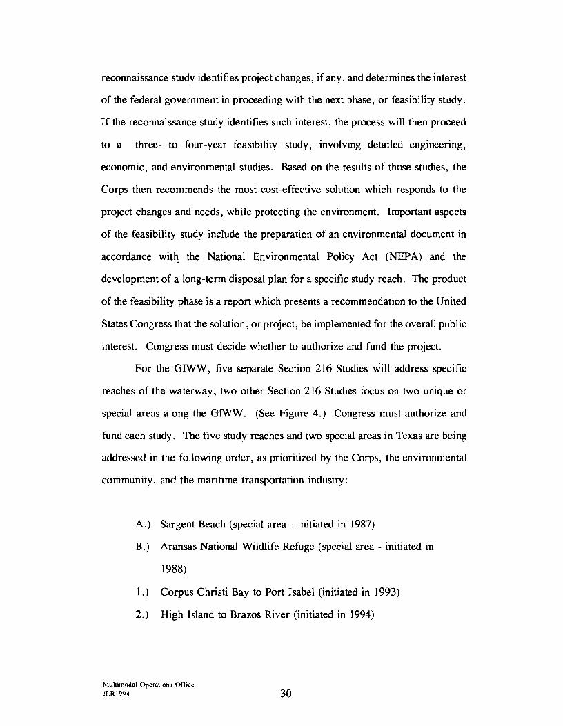
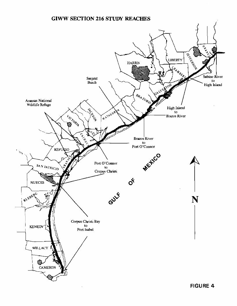
For the GIWW, five separate Section 216 Studies will address specific
reaches of the waterway; two other Section 216 Studies focus on two unique or
special areas along the GIWW. (See Figure 4.) Congress must authorize and
fund each study. The five study reaches and two special areas in Texas are being
addressed in the following order, as prioritized by the Corps, the environmental
community, and the maritime transportation industry:
A.) Sargent Beach (special area - initiated in 1987)
B.) Aransas National Wildlife Refuge (special area - initiated in
1988)
1.) Corpus Christi Bay to Port Isabel (initiated in 1993)
2.) High Island to Brazos River (initiated in 1994)
~lultimodal Operations Office JLRI994 30
Aransas National Wildlife Refuge
GIWW SECTION 216 STUDY REACHES
Sargent Beach
to _.'----- Brazos River
Brazos River to
Port O'Connor
o«-
N
FIGURE 4
3.) Port O'Connor to Corpus Christi Bay (scheduled to begin in
1995)
4.) Brazos River to Port O'Connor (scheduled to begin in 1996)
5.) Sabine River to High Island ( scheduled to begin in 1997)
Sargent Beach
The reconnaissance phase of the Section 216 Study addressing the ten-mile
reach of the Sargent Beach special area was completed in 1989. The feasibility
phase, which was completed in 1992, included the development of an
Environmental Impact Statement (EIS). The study findings recommended that an
eight-mile, combination concrete-block revetment and concrete sheetpile wall be
constructed against the eroding forces of the Gulf of Mexico to stabilize the beach
at Sargent, Texas in Matagorda County. The protective seawall would not only
prevent further erosional losses of property and high quality wetland habitats, but
would also eliminate the need to relocate the waterway through wetlands.
The construction of two mooring facilities, necessary for construction of
the eight-mile seawall, commenced in 1994. Advertisement for contract bids to
construct the $80 million project is scheduled for February 1995 11 • Funding will
be accomplished by 50 percent federal treasury and 50 percent from the Inland
Waterways Trust Fund.
The Corps's real estate acquisition process for the seawall project neared
completion in 1994. A minimum number of tracts were expected to undergo
condemnation proceedings for parcels that either had title problems or great
disparity between the appraised value and the landowner's asking price. Three
11 U.S. Army Corps of Engineers. District Commander's Executive Summary. Galveston District, October Reports. November 9, 1994, p. 3-4.
Multimodal Operations Office JLR1994 32
small TxDOT parcels of disposal acreage were acquired by the Corps for the
seawall project. The parcels consisted of a minimal portion of TxDOT upland
disposal properties in Matagorda County.
Aransas National Wildlife Refuge
This Section 216 Study addresses the 30-mile special area reach
encompassing the Aransas National Wildlife Refuge and extending to include
much of the endangered whooping cranes' critical habitat. The study is in the
final stages of the feasibility phase. The four-year feasibility study, initiated in
September 1990, will include an evaluation of the possible realignment of the
waterway, develop various beneficial uses of dredged material, and will generate
a plan for implementation. The study's primary objective is to evaluate a means
of reducing bank erosion along the GIWW within the environmentally sensitive
wildlife refuge and whooping cranes' critical habitat.
Study activities during fiscal years 1993-1994 included environmental
coordination for an Environmental Impact Statement and efforts toward finalizing
the feasibility report. Implementation of the study' s final recommendations is
scheduled for 199812 .
Corpus Christi Bay to Port Isabel
In July 1994, the Corps submitted a draft report to Washington, D.C.
headquarters on the Section 216's reconnaissance study of the 117-mile reach from
Corpus Christi Bay to Port Isabel. This report, however, which addresses the
GIWW reach through the Laguna Madre, was released before certification was
12U. S. Army Corps of Engineers. District Commander's Executive Summary. Galveston District, October Reports. November 9, 1994, p.4.
Multimodal Operations Office JLR1994 33
obtained from the Corps' Washington, D.C. headquarters. Due to litigation in
September 1994, which involved GIWW maintenance dredging and disposal in the
Laguna Madre, the U.S. Justice Department subsequently released the report,
bearing a disclaimer of the report's unofficial status. The unofficial
reconnaissance report listed the following points concerning the GIWW:
+ The existing channel is economically justified,
+ There is no interest in a Port Isabel realignment plan,
+ There exists a large-scale ecosystem restoration plan,
+ There exists a feasible long-term disposal plan,
+ Continuing the study into the feasibility phase is recommended 13 •
After the Corps' Washington, D. C. headquarters conducted a review of the
reconnaissance report, the headquarters requested that the Galveston District
Corps restructure the study based on more traditional navigation features.
Subsequently, for the Section 216 reconnaissance study of the Corpus Christi Bay
to Port Isabel reach, the Corps' Galveston District will evaluate the channel's
navigation features.
High Island to Brazos River
In February 1994, the Corps initiated the reconnaissance phase for the 85-
mile reach of the High Island to Brazos River Section 216 Study. In order to
discover any physical or economic problems associated with this section of the
GIWW, the Corps initiated a vigorous public involvement program. A large
13U .S. Army Corps of Engineers. District Commander's Executive Summary, Galveston District, October Reports. November 9, 1994, p. 15.
Multimodal Operations Office JLRl994 34
number of comments and concerns were received and can be categorized as
follows: environmental problems and opportunities; long-term disposal plan;
dredging frequency/shoaling; eroding areas needing repair; mooring problems and
opportunities; navigation problems; problems which fall under other programs or
agencies; and problems outside the scope of this study. 14
In addition, significant interest was expressed in a beach nourishment
project at Rollover Pass and a bend easing of the GIWW at the State Highway 332
bridge near Freeport, Texas. The reconnaissance study, which is scheduled for
completion in 1995, will continue to evaluate whether a federal interest exists in
resolving concerns or increasing efficiency of the waterway in this reach.
Port O'Connor to Corpus Christi Bay
The Section 216 's reconnaissance study of the 79-mile reach from Port
O'Connor to Corpus Christi Bay is scheduled to begin in 1995 and will require
approximately one year for completion. Schedules are subject to change due to
congressional action, as Section 216 Study projects must compete with other
activities nationwide for limited financial resources.
Brazos River to Port O'Connor
The tentative start date for the 72-mile reach of the Brazos River to Port
0 'Connor Section 216 's reconnaissance study is 1996, with completion in
approximately one year. This schedule is subject to change by congressional
action, as Section 216 Study projects must compete with other activities
nationwide for limited financial resources.
14U.S. Army Corps of Engineers. District Commander's Executive Summary. Galveston District. October Reports. November 9, 1994, p. 14-15.
Multimodal Operations Office JLR1994 35
Sabine River to High Island
For the 50-mile Sabine River to High Island reach, the Section 216's
reconnaissance study is tentatively scheduled for 1997 with an approximate one
year completion period. As with all Section 216 Studies, this schedule is subject
to change, pending congressional actions.
Summation
For those Section 216 Studies which proceed through the feasibility phase,
long-term disposal plans would be developed. It is anticipated that those plans
will aid planning efforts of the state to act as nonfederal sponsor of the GIWW.
Furthermore, those plans will likely include some implementation of beneficial
uses of dredged material. The state is not currently authorized to help fund such
projects; however, that is addressed in this report's chapter on legislative
recommendations.
Other Studies
In addition to the Section 216 Studies, TxDOT became involved in several
other studies that address various needs associated with the GIWW in Texas.
During fiscal years 1993-1994, TxDOT supported the following studies: "Closure
of the Gulf Intracoastal Waterway and its Impact on the Texas Highway
Transportation System," by the Texas A&M University's Texas Transportation
Institute; a Section 1135 Seagrass Study (see Appendix B) in the lower Laguna
Madre by the Corps; "System Planning for the Inland Waterway and Port System
in Texas" by the University of Texas' Center for Transportation Research; and a
proposed study on erosion protection technology at Christmas Bay (Galveston
Multimodal Operations Office JLR1994 36
County). TxDOT has also reviewed the need for a study to develop a short-term
interim plan for dredged material disposal.
Closure of the Waterway Study
TxDOT contracted the Texas A&M University's Texas Transportation
Institute to evaluate the impacts that an interruption in the GIWW' s operations
would have upon other modes of transportation. The results were published in a
1993 study titled, "Closure of the Gulf Intracoastal Waterway and its Impact on
the Texas Highway Transportation System." This study predicts that, in the event
of a long-term GIWW closure, approximately 52 % of the tonnage currently being
transported along the waterway could be shifted to other modes of transportation
(truck and rail). However, this modal shift would result in significantly higher
fuel costs and vehicular emissions. Escalated traffic would also decrease the life
span of roadway pavements, thus increasing maintenance costs. The modal shift
would have a more limited impact, however, on traffic congestion, hazardous
materials movement, and accident rates. 15
Section 1135 Seagrass Study
In the lower Laguna Madre, TxDOT is participating in a Section 1135 (see
Appendix B) Seagrass Enhancement Study sponsored by the Corps. From this
study, timed to correspond with the November 1994 maintenance dredging of the
Port Isabel to Arroyo Colorado reach of the GIWW, data will be gathered from
a modification to the existing dredged material disposal plan, and then evaluated.
15Roop, Stephen S.; Daryl U. Wang; Richard W. Dickinson; and Gordon M. Clarke. Closure of the Gulf Intracoastal Waterway and its Impact on the Texas Hiehway Trans_portation System. Research Report 1283-2F. College Station, Texas: Texas Transportation Institute, 1993, p.84.
Multimodal Operations Office JLRl994 37
The project modification consists of transplanting seagrass from nearby
undisturbed seagrass meadows onto freshly deposited dredged material within two
of the GIWW's designated open-water placement areas. The intent of the study
is to determine whether dredged material placement operations can be adjusted to
increase the seagrass colonization rate between dredging cycles. In addition, the
project will ascertain whether placement modifications will improve habitat value
for estuarine life in open-water placement corridors (also known as open-water
disposal areas).
Inland Waterway and Port Systems Study
In line with TxDOT's mission to provide safe, effective, and efficient
movement of people and goods, the agency has contracted a study with the
University of Texas' Center for Transportation Research to develop a
comprehensive strategic plan and planning process for Texas' inland waterway and
port system. This strategic plan will be coordinated with the ongoing statewide
transportation plan. The Texas inland waterway and port system plays a vital role
in the flow of commerce on the state's multimodal transportation network.
The contracted study will develop and document a comprehensive strategic
planning process for the Texas inland waterway and port system, including
intermodal linkages to rail and other transportation modes and in coordination with
the emerging statewide multimodal transportation planning process. The scope of
work includes: 1) conducting an analysis of the facilities and operations of the
inland waterway and port system; 2) conducting an analysis of connecting rail and
other transportation modes; 3) conducting an analysis of current and future traffic
flows along the waterway and at each of its connecting ports; 4) identifying and
examining current plans to improve efficiency of operations and to invest in
Multimodal Operations Office JLRI994 38
expansion of facilities; 5) determining waterway and port deficiencies and
identifying alternative solutions and other methods of assisting maritime commerce
in Texas; 6) preparing a comprehensive waterway and port plan in coordination
with the statewide multimodal transportation plan; and 7) developing
implementation and updating procedures for the state of Texas.
Christmas Bay Erosion Protection Study
The U.S. Fish and Wildlife Service revealed a proposal in April 1994 for
an erosion-protection study where the GIWW parallels the environmentally
significant Christmas Bay in Galveston County. A designated Coastal Preserve,
Christmas Bay is separated from the GIWW by only a narrow strip of land. This
narrow strip could breach from ongoing erosion, impacting the bay's ecosystem
and introducing shoaling, or sedimentation, to an area of the GIWW which has
required no maintenance dredging since its construction. This erosion-protection
study, scheduled for 1995, will evaluate the effectiveness of concrete matting
technology between two bodies of water. TxDOT plans to cost-share in this study
with the U. S. Fish and Wildlife Service to gather valuable technical information,
which the Corps could extract for other similar situations.
TxDOT Interim Maintenance Plan
Through its planning efforts, TxDOT has reviewed the need for a study to
address the state's short-term needs for GT.WW maintenance disposal. Referred
to as the "Interim Plan for Maintenance and Development of the GIWW," the
interim plan would facilitate cooperation between TxDOT, the Corps, and other
state and federal agencies to identify suitable dredged material placement sites
along the GIWW. The interim plan would develop estimates of expected
Multimodal Operations Office JLR1994 39
quantities of dredged material over a pre-determined period, plus costs and
impacts of alternative disposal methods.
Beneficial Uses of Dredged Material
The Corps of Engineers spends an average of $13 million dollars every
year to dredge approximately eight million cubic yards of material from the Texas
GIWW. The historical locations for placement of this dredged material are
designated open-water and upland sites. However, as environmental objections
to open-water placement increase and as upland placement sites become less
available due to technical, economic, and environmental considerations,
alternatives to the traditional placement methods must be explored.
One alternative to traditional disposal methods is the beneficial use of
dredged material. The key to effectively using dredged material in productive,
beneficial ways lies in regarding the material as a useful resource, rather than an
unwanted by-product. For the most part, dredged material from the GIWW has
tested as uncontaminated and, therefore, is feasible for beneficial uses.
In recent years, the Corps has focused on such opportunities, identifying
ten broad categories of beneficial uses, based on the dredged material's function
at the placement site. These beneficial use categories include the following:
habitat development; beach nourishment; aquaculture; parks and recreation;
agriculture; forestry and horticulture; strip mine reclamation, solid waste
management, shoreline stabilization and erosion control; construction and
industrial use; material transfer (fill, dikes, levees, parking lots, roads); and
multiple purposes, i.e., the combination of categories on a dredging project. As
this list indicates, dredged material has the potential to be productive in a wide
variety of dredging projects.
Multimodal Operations Office JLRI994 40
During fiscal years 1993-1994, the Corps addressed several beneficial use
projects along the waterway in Texas. (See Figure 5 for the general locations.)
Three wildlife habitat creation projects and a habitat replenishment project applied
the use of dredged material from GIWW maintenance operations. A description
of these beneficial use applications and a similar planned project is presented
below.
Aransas National Wildlife Refuge
In the Aransas National Wildlife Refuge, the Corps used dredged material
to create marshes suitable for whooping crane habitat within two of the
waterway's designated placement areas. On Disposal Area 127A (see Figure 6),
the Corps used a low-crest, rock breakwater to protect containment levees
composed of stiff clay. Maintenance dredged material was then placed within the
levees to create marsh habitat for the endangered cranes. For Disposal Area 128
(see Figure 7), an island experiencing erosion, geotextile tubes were filled with
maintenance dredged material that had a high sand content. The filled tubes
formed erosion barriers. Additional dredged material was then carefully placed
inside the erosion barriers to form the desired marsh habitat for the whooping
cranes. Both beneficial use sites were sprigged with marsh vegetation after
allowing the dredged material to consolidate.
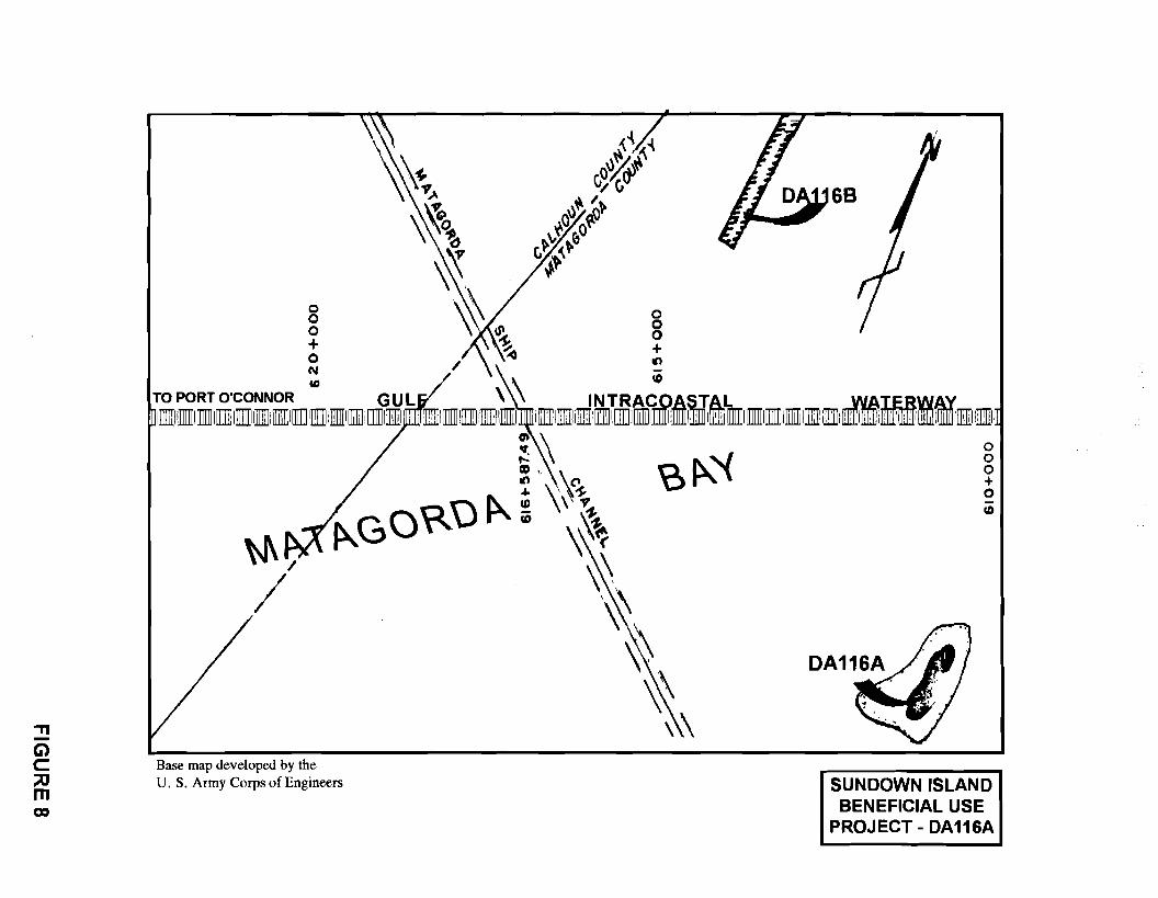
Sundown Island
Sundown Island is located in Matagorda Bay near the intersection of the
GIWW and the Matagorda Ship Channel. This island forms a portion of Disposal
Area 116A (see Figure 8), an unconfined, partially emergent disposal area. The
50-acre emergent portion of the disposal area supports a variety of waterbird
Multimodal Operations Office JLRI994 41
KENEDY
BENEFICIAL USE PROJECTS ONTHEGIWW
1993-1994
Sundown Island
Aransas National Wildlife Refuge N
Rollover Bay (potential project)
FIGURE 5
Base map developed by the U.S. Army Corps of Engineers.
GIWW
Base map developed by the U.S. Army Corps of Engineers.
'Tl -Ci) C :::0 m a,
\\(\1-~ ~"
\~o \ ~
~
0 "· \ g ~ ~ 8 ~ ~ + N / ~
68
'° \ ~ TO PORT O'CONNOR GUL \ \\ INTRA@ASJAL -.WAI.ERWAY 1~1 l]]Ill [[]]]] I [illj] Ill]]] l]ill: [[]]]]I[[]]]] IJTI!ii illlIII [[]]]] i [[]]]]llll!ll 1:, · '.TIII [[]]]] l[II i!ilIIIII!IIII i [[]]]] l]]ffi Lill[[]]]] I[[]]]] I IlillJ lilllII l]l]]I ill]] I [l]]jj 1]]]]11]]]]1 [l]]jj, [ill]] llllIII iI:[: Uilll I illlli il±l llillll Ullli! lilllJ llllIII llTIIII:,
W\ / I
Base map developed by the U. S. Army Corps of Engineers
0 0 0 + 0 Cb
SUNDOWN ISLAND BENEFICIAL USE
PROJECT- DA116A
nesting colonies including brown pelicans, herons, egrets, ibises, roseate
spoonbills, gulls, terns, and black skimmers.
During maintenance dredging of the waterway, material is placed on the
northwest, submerged portion of the disposal area in order to protect the emergent
portion from erosion. In September 1992, 163,000 cubic yards of dredged
material were placed in this manner. To avoid negative impacts to nesting birds
during the dredged material placement, precautions were taken, such as restricting
operations to the birds' non-nesting season and prohibiting all personnel and
equipment from the emergent island. When this reach of the waterway is dredged
again in 1995, approximately 230,000 cubic yards of dredged material will be
placed in a similar manner to further nourish and protect this island.
Halls Lake
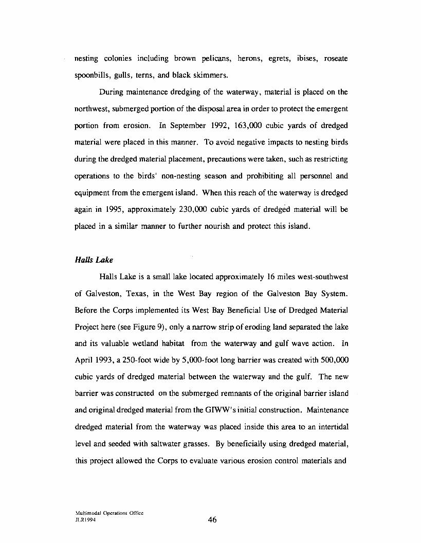
Halls Lake is a small lake located approximately 16 miles west-southwest
of Galveston, Texas, in the West Bay region of the Galveston Bay System.
Before the Corps implemented its West Bay Beneficial Use of Dredged Material
Project here (see Figure 9), only a narrow strip of eroding land separated the lake
and its valuable wetland habitat from the waterway and gulf wave action. In
April 1993, a 250-foot wide by 5,000-foot long barrier was created with 500,000
cubic yards of dredged material between the waterway and the gulf. The new
barrier was constructed on the submerged remnants of the original barrier island
and original dredged material from the GIWW' s initial construction. Maintenance
dredged material from the waterway was placed inside this area to an intertidal
level and seeded with saltwater grasses. By beneficially using dredged material,
this project allowed the Corps to evaluate various erosion control materials and
Multimodal Operations Office JLR1994 46
\0 Base map developed by the U.S. Army Corps of Engineers.
levee construction techniques while simultaneously creating a wetland erosion
barrier that would shield the mainland from effects of wind and wave action.
Long Reef
Long Reef, located in Aransas Bay, is a natural reef along which lies a
chain of islands near the main channel of the GIWW. The northernmost island
in the chain provides three acres of colonial waterbird nesting habitat for herons,
egrets, gulls, terns, and black skimmers. In January 1994, the Corps enhanced
this island, which lies within Disposal Area 134 (see Figure 10), by using
maintenance dredged material. Approximately 114,000 cubic yards were placed
uniformly along the island shore to protect it from erosion. Precautions were
taken during the operations to avoid negative impacts to nesting birds.
Rollover Bay
Rollover Bay, a small bay south of East Bay in Galveston County, cuts
through the Bolivar Peninsula by way of the Rollover Pass which flows under
State Highway 87 and continues into the Gui f of Mexico ( see Figure 11). The
beach on the gulf side of the peninsula west of Rollover Pass is eroding at a
considerable rate. Because of various physical factors, the involved state and
federal agencies have agreed that this area has excellent potential for beach
nourishment through the beneficial use of dredged material from maintenance of
the nearby GIWW. The Texas General Land Office has officially requested that
the Corps conduct a Section 933 Study (see Appendix B) of the situation and is
currently acting as the nonfederal local sponsor of this study. To help the Corps
offset expenses associated with the beneficial use project, which will be above the
typical maintenance cost for this reach of the waterway, TxDOT has solicited
Multimodal Operations Office JLR1994 48
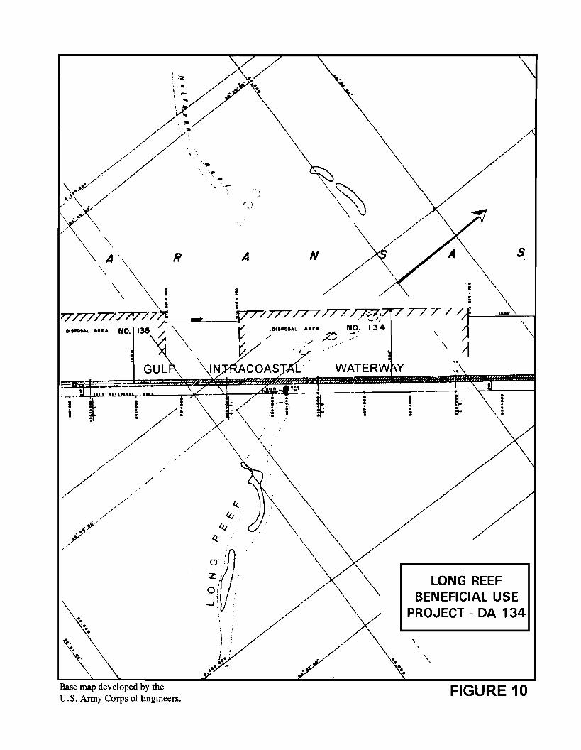
\ .~ ..
~~ \~-
\
'
111-Hl&
\
: '11: .. I •-
R
i
/
/
Base map developed by the U.S. Anny Corps of Engineers.
\.
-~ ..
I •
'···, -.:
A N
7 7T7 /TT/TT~\ . -· (. ~..= Dlll'OUL AH& NO. I 3 4
/ ~ -.. /<-/ - •
s
., .... \
\ ~
..
LONG REEF BENEFICIAL USE
PROJECT - DA 134
' ' \
FIGURE 10
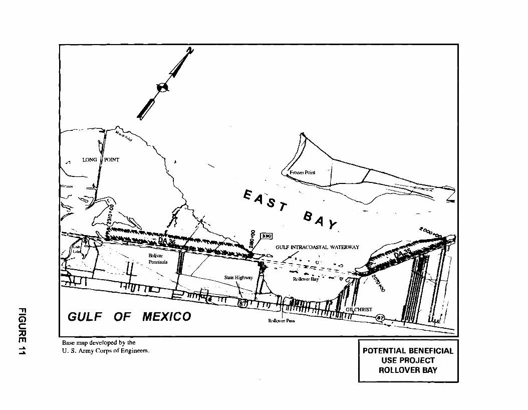
.,, -G) C ~ m ..... .....
GULF OF MEXICO
Base map developed by the U. S. Army Corps of Engineers.
. GUIF JNfRACOASTAL WATERWAY
../ . --- L·" . . G-~ ------- . ,· ·~
Q ~, ~ - :=r .,e;, -=- -=- ~ ~ . -- . .. -- -
Rollover Bay • -- O'
POTENTIAL BENEFICIAL USE PROJECT
ROLLOVER BAY
various parties to share in those additional costs. Additionally, TxDOT has
investigated the possiblity of providing an easement under State Highway 87 to
provide disposal pipeline access to Rollover Beach.
Acquisitions and Conveyances
For the 1994-1995 biennium, the Texas Legislature appropriated 1.5
million dollars for acquiring disposal sites requested by the Corps of Engineers
which would facilitate maintenance dredging of the GIWW. It is estimated that
approximately 930 acres could be purchased with that funding. In order to
continue support for the waterway in an environmentally sound manner, the state,
as the nonfederal sponsor, will continue its upland disposal site acquisition
program. Continued state funding will be needed to implement this method of
disposing materials dredged from the waterway.
During fiscal years 1993-1994, TxDOT completed the acquisition of two
upland sites for the placement of dredged material in Matagorda County.
Although the Texas Transportation Commission authorized acquisition of these
sites several years ago, in 1988, lengthy title clearance and condemnation
proceedings have delayed the actual fee title acquisition. Disposal Area 99, shown
on Figure 12, is 45.94 acres; the other site, Disposal Area 100, is 86.65 acres.
TxDOT will soon convey thirty-year easements to the Corps for these two
upland sites. In addition, TxDOT is scheduled to arrange a similar conveyance
in 1995 on an 89. 1 acre Aransas County site referred to as Disposal Area 14 7 A.
TxDOT acquired this site, depicted in Figure 13, during the previous biennium
in 1992.
Efforts in the fiscal years 1993-1994 to acquire a 179. 96 acre site in
Galveston County may result in a completed acquisition in 1995. Referred to as
Multimodal Operations Office JLR1994 51
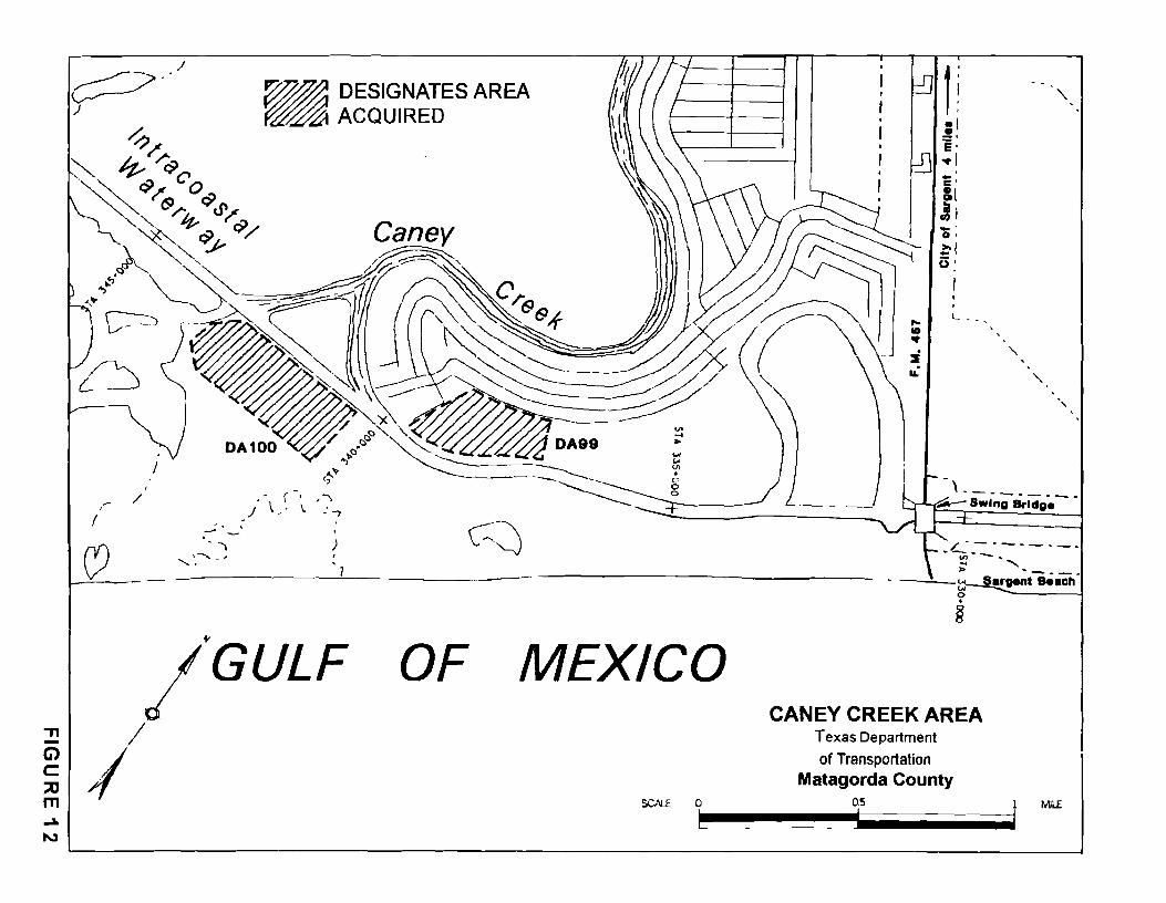
J ~--)
,,.. /
( -.
/.GULF :!! /
~ I m .... 9'.J
OF MEXICO CANEY CREEK AREA
Texas Department
of Transportation Matagorda County
'\.
' '
SCN.E O 0.5 l Mil£
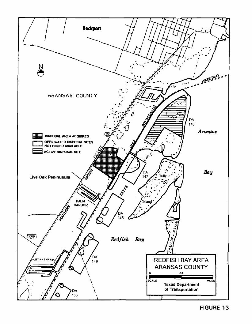
Rodcport
N e
ARANSAS COUNTY
Gill DISPOSAL AREA ACQUIRED
r--, OPEN WATER DISPOSAL SITES L....-J NO LONGER AVAILABLE
E;J ACTIVE DISPOSAL SITE
Live Oak Peninusula
\
\ \
\ '
fl ( .... -
... '
I' ,.,'11
Red/ish. Bay
0
Aransas
Bay
REDFISH BAY AREA ARANSAS COUNTY
SCALE ,._ES Texas Department of Transportation
FIGURE 13
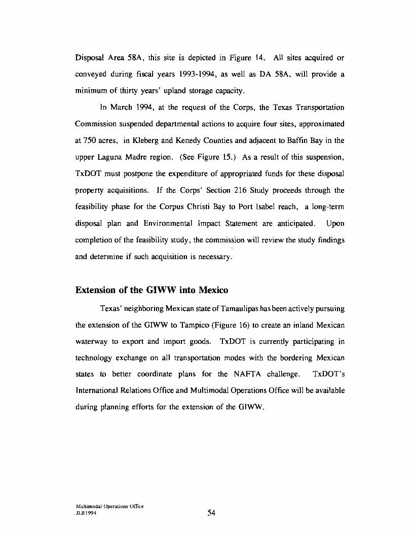
Disposal Area 58A, this site is depicted in Figure 14. All sites acquired or
conveyed during fiscal years 1993-1994, as well as DA 58A, will provide a
minimum of thirty years' upland storage capacity.
In March 1994, at the request of the Corps, the Texas Transportation
Commission suspended departmental actions to acquire four sites, approximated
at 750 acres, in Kleberg and Kenedy Counties and adjacent to Baffin Bay in the
upper Laguna Madre region. (See Figure 15.) As a result of this suspension,
TxDOT must postpone the expenditure of appropriated funds for these disposal
property acquisitions. If the Corps' Section 216 Study proceeds through the
feasibility phase for the Corpus Christi Bay to Port Isabel reach, a long-term
disposal plan and Environmental Impact Statement are anticipated. Upon
completion of the feasibility study, the commission will review the study findings
and determine if such acquisition is necessary.
Extension of the GIWW into Mexico
Texas' neighboring Mexican state ofTamaulipas has been actively pursuing
the extension of the GIWW to Tampico (Figure 16) to create an inland Mexican
waterway to export and import goods. TxDOT is currently participating in
technology exchange on all transportation modes with the bordering Mexican
states to better coordinate plans for the NAFTA challenge. TxDOT' s
International Relations Office and Multimodal Operations Office will be available
during planning efforts for the extension of the GIWW.
Multimodal Operations Office JLR1994 54
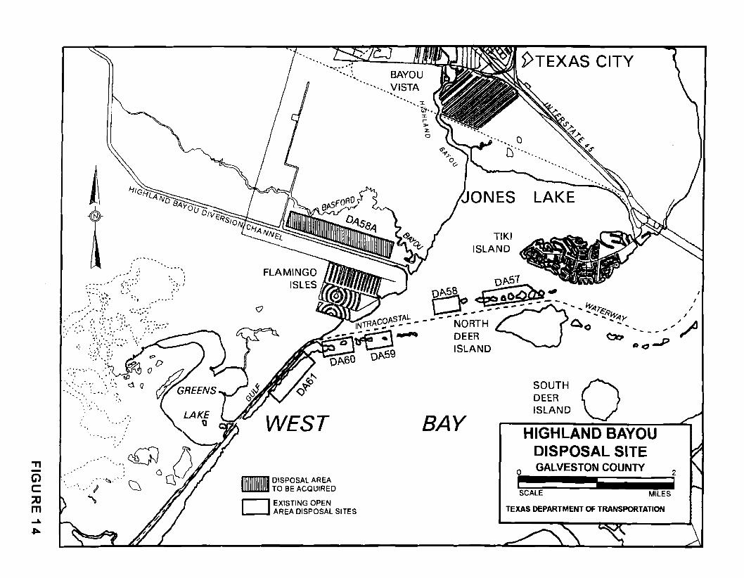
'Tl -G) C ::u m
, • ,ti
,, ... . " , . -, '
:';•.''. ' . .... - ... :~\~ '--' .. : •.-:ii~·,. ' l - - •
, ..... , ~ .. ,. ... ',' .. - ..
:.' .. -,:~:. ::,:., ?:::.,:/\~--~--\-_:":.·::· -;', ·-
:1 .. ~.~.~(~/; .. ~ · .. , .... ,· .,
',, ' ' ' ' '
Q
lll11Tl11TI1TI DISPOSAL AREA lllWllllllll TO BE ACQUIRED
D EXISTING OPEN AREA DISPOSAL SITES
:i: r > z 0
5>TEXAS CITY
()
D·· .. .. "· ....
~ONES LAKE
BAY
TIKI ISLAND
0
SOUTH 0 DEER ISLAND
HIGHLAND BAYOU DISPOSAL SITE GALVESTON COUNTY
SCALE MILES
TEXAS DEPARTMENT OF TRANSPORTATION
2
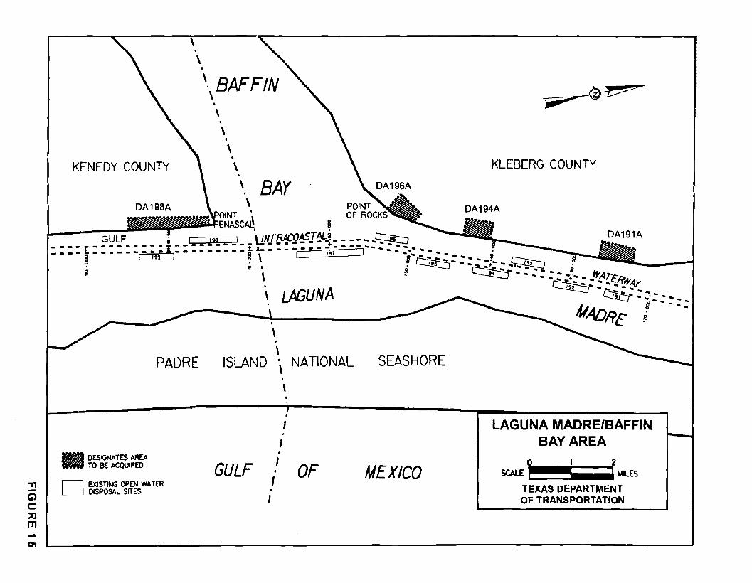
-n -G) C ::::0 m ... (.l'I
\
KENEDY COUNTY
. \BAFFIN
• \ • \ . \ • \
' BAY \
OINT • ENASCA~ § . .
KLEBERG COUNTY
GULF i 1 '" _] \lNTRICO~J~J- - - - - -~ - - - - t - - - - • - .. - • I.~• - • - • - - E. - : - : - • - .:- • - - - -- : - .. - -DA191A
.,. • • • • • • • • • • • • • • • • • • • • • SI &.. • • L lt7 ] - - _+ • - • • Sl ! 19' ! II \ - §- - "" - "" - i ~ . ~--:-----~
DESIGNATES AREA TO BE ACQI.JRED
PADRE
D EXISTlt.¥:; OPEN WATER DISPOSAL SITES
~. . ~ ~--·---~ .. \ ~ I f • - .. - • - "" .J lf/.A .,.r" , .. -~: ,:,~~/rHt,4y , , A~u NA -~ = =·- -.. . ~ ~- §- --
41ADR£ i - - .. -• \ . \
ISLAND · \ I
\ . . I
I . GULF I .
I I
I
NATIONAL SEASHORE
OF MEXICO
LAGUNA MADRE/BAFFIN BAY AREA
0 2 SCAl£ MILES
TEXAS DEPARTMENT OF TRANSPORTATION
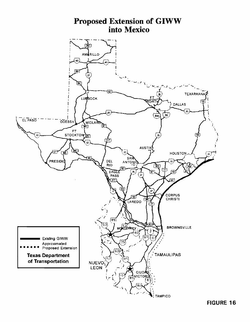
Proposed Extension of GIWW into Mexico
~ .. ·-·
, 287
; AM RILLO
1
EL PASO . - . - . - . - -1
•••••• Existing GIWW Approximated Proposed Extension
Texas Department of Transportation
I.
'- . .._,., .. r .l, . . -
..._ L,..~ ,,,J;.,.... ~ f. """' f . ./ - '
,,-·
BROWNSVILLE
• TAMAULIPAS
• : TAMPICO
FIGURE 16

!!!!!!!!!!!!!!!!!!!"#$%!&'()!*)&+',)%!'-!$-.)-.$/-'++0!1+'-2!&'()!$-!.#)!/*$($-'+3!
44!5"6!7$1*'*0!8$($.$9'.$/-!")':!
Chapter Four
LEGISLATIVE RECOMMENDATIONS

!!!!!!!!!!!!!!!!!!!"#$%!&'()!*)&+',)%!'-!$-.)-.$/-'++0!1+'-2!&'()!$-!.#)!/*$($-'+3!
44!5"6!7$1*'*0!8$($.$9'.$/-!")':!
LEGISLATIVE RECOMMENDATIONS
Transportation clearly plays an important role in today's movement of
people and goods and it will lead us into the future, where multimodal
transportation will provide that movement most effectively. As we move into the
21st century, not only will our state's activities continue to increase, but national
and international activities will also provide additional transportation challenges.
We must, therefore, recognize the importance of maintaining a modern and
diversified transportation infrastructure.
In support of that infrastructure and as the nonfederal sponsor of the Gulf
Intracoastal Waterway (GIWW), the Texas Department of Transportation
(TxDOT) advocates the continued maintenance and operation of the GIWW, while
fostering the protection and enhancement of the coastal environment. To facilitate
maintenance of the waterway, TxDOT acquires upland property through gift,
purchase or condemnation and furnishes an easement to the U.S. Army Corps of
Engineers (Corps) for use as a dredged material disposal site. Although TxDOT' s
preferred method of acquiring sites is to accept or purchase an unencumbered title
through negotiations, it is at times necessary to condemn the property through the
authority of eminent domain. This authority is crucial to the continued support
of the waterway's maintenance program.
Disposal options to facilitate necessary maintenance dredging projects are
becoming an increasingly complicated issue. Objections to open-water disposal,
reduced availability of upland sites, and prohibitive costs of pumping dredged
material over long distances to more environmentally acceptable sites are some of
the challenges faced in continuing to provide for safe and effective transportation
on the waterway.
Multimodal Operations Office JLR1994 61
As indicated earlier in this report, the beneficial use of materials dredged
from the GIWW is becoming a more frequent alternative to the traditional disposal
of maintenance materials. However, the costs of implementing beneficial use
projects often exceed standard maintenance costs and the Corps' fixed budgets.
In this regard, the nonfederal sponsor may be looked upon to fund those extra
costs. To help offset those costs, the state could implement a research and
technology program to identify uses and economic benefits of dredged material.
Other alternatives to traditional disposal methods may become necessary
in instances where beneficial uses of dredged material will not be feasible. These
alternatives may involve the movement of dredged material over longer distances,
or perhaps a modification of traditional disposal operations to avoid or minimize
adverse environmental impacts. Either alternative can cost more than traditional
maintenance operations.
The Corps is actively pursuing studies through the authority of Section 216
of the Federal Flood Control Act of 1970. These studies and their
recommendations may lead to the Corps' ability to participate in beneficial use
projects or alternative disposal methods with adequate funding. However, the
studies are not planned to reach fruition until at least the year 2001. Until then,
it may become necessary to provide some assistance to the Corps for beneficial
use projects or other alternative disposal methods.
To support the state's nonfederal sponsorship of the GIWW in Texas and
facilitate planning, maintenance, preservation, research, and improvement of the
waterway, the following are recommended for consideration by the Texas
Legislature:
!vlultimodal Operations Office JLR1994 62
The state continue to recognize and promote the Gulf Intracoastal
Waterway as an integral and valuable part of the state's multimodal
transportation system.
The state provide the authority for the participation and funding to
support the Gulf Intracoastal Waterway's projects using dredged
material for beneficial purposes.
The state advocate the continuation of the U.S. Army Corps of
Engineers' Section 216 Studies, which will address the physical
and/or economical changes of the Gulf Intracoastal Waterway in
Texas.
Multimodal Operations Office JLR1994 63

!!!!!!!!!!!!!!!!!!!"#$%!&'()!*)&+',)%!'-!$-.)-.$/-'++0!1+'-2!&'()!$-!.#)!/*$($-'+3!
44!5"6!7$1*'*0!8$($.$9'.$/-!")':!
Appendix A
THE ACQUISITION PROCESS

!!!!!!!!!!!!!!!!!!!"#$%!&'()!*)&+',)%!'-!$-.)-.$/-'++0!1+'-2!&'()!$-!.#)!/*$($-'+3!
44!5"6!7$1*'*0!8$($.$9'.$/-!")':!
APPENDIX A
The Acquisition Process
Introduction and General Summary
To acquire needed disposal sites, the Texas Department of Transportation
(TxDOT) coordinates within its appropriate divisions, districts, and special offices
to handle land acquisitions. Several items are important in making acquisitions
for disposal sites, including an understanding of applicable state and federal laws,
identification of suitable sites, obtainment of required environmental clearances,
public involvement, site-specific authorization, and promulgation of appropriate
acquisition procedures. TxDOT's standard right-of-way acquisition procedures
fully comply with the federal requirements of the nonfederal sponsor, and these
procedures are followed in acquiring the sites.
Through the U. S. Army Corps of Engineers (Corps), TxDOT has access
to information on dredging frequencies, volumes of materials removed, and
various disposal methods that are environmentally and operationally suitable for
maintenance of the Gulf Intracoastal Waterway (GIWW) in Texas. TxDOT also
consults with natural resources agencies regarding disposal-related environmental
concerns. All these factors help determine the need for disposal capacity,
location, size, and design of disposal sites.
Steps to Site-Specific Authorization
Selection of Proposed Sites
TxDOT has organized a state agency advisory committee, the Gulf
Intracoastal Waterway Advisory Committee (GIWAC) (see page 15), to help
Multimodal Operations Office JLR1994 67
address problems and recommend solutions concernmg the waterway. To
physically investigate coastal areas that need new or additional disposal capacity,
TxDOT appoints members from GIWAC and representatives from federal
agencies that include the National Marine Fisheries Service, U. S. Army Corps
of Engineers, and U. S. Fish and Wildlife Service, to serve on a task force. This
task force of engineers and resource experts makes preliminary identifications of
environmentally and operationally suitable sites in the areas of need. After this
preliminary identification and with the concurrence of GIW AC, the Corps
proceeds to obtain the environmental clearance for use of the proposed sites.
Only after environmental clearance has been assured will TxDOT conduct the
required public hearings on specific sites. As part of the hearing process, the
Texas Transportation Commission must grant authorization to the agency for
proceeding with site-specific acquisitions.
Environmental Clearance
In order for any area to be used for disposal of dredged material, there are
federal and state laws which mandate that such use be environmentally acceptable.
The National Environmental Policy Act sets federal guidelines which the Corps
must follow in making environmental evaluations of proposed sites. The Texas
Coastal Waterway Act of 1975 requires that the Texas Transportation Commission
determine whether proposed sites can be used without unjustifiable waste of
publicly or privately owned natural resources and without permanent, substantial,
adverse impact on the environment, wildlife, or fisheries.
Agencies involved with protecting natural and historical resources (the
National Marine Fisheries Service, Texas General Land Office, Texas Parks and
Wildlife Department, Texas Historical Commission, Texas Natural Resource
Multimodal Operations Office JLR1994 68
Conservation Commission, and U. S. Fish and Wildlife Service) assist m
developing recommendations during the environmental evaluation. After the
environmental evaluation is completed and a proposed site has been found to be
acceptable for disposal use, the Corps documents the analysis in an environmental
assessment and issues a finding of no significant impact (EA/FONSI). The
environmental assessment and finding of no significant impact is forwarded to the
Environmental Protection Agency and TxDOT.
A final review of the environmental assessment and findings is conducted
by TxDOT. If TxDOT determines the disposal site can be used in an
environmentally acceptable manner, the agency then proceeds 'with the required
public hearings for the site.
The environmental documents are kept on file at TxDOT and the Corps'
Galveston District.
Public Involvement
The 1975 Texas Coastal Waterway Act requires the Texas Transportation
Commission to hold public hearings for the purpose of receiving evidence and
testimony concerning the desirability of proposed dredged material disposal sites.
If the commission determines that use of the sites is acceptable, the commission
then authorizes the agency to proceed with acquisition. To better inform
communities of the proposed use of an area, TxDOT often conducts public
meetings prior to the mandated public hearings. Public meetings are held in cities
located near the proposed sites; the public hearings are held in Austin.
Public hearings are advertised in accordance with the 1975 Texas Coastal
Waterway Act. Legal notices are published in newspapers that are circulated in
Multimodal Operations Office JLR1994 69
the involved counties for three consecutive weeks before the public hearings, as
well as in the Texas Register.
Environmental documents and aerial displays regarding the proposed sites
are exhibited at the public meetings and hearings. The proceedings of each forum
are documented and become part of official record. During these public forums,
TxDOT explains the state's nonfederal responsibility for the GIWW, describes the
waterway's maintenance program and disposal needs, and identifies the proposed
sites. The public is given the opportunity to comment.
Commission Authorization
After due consideration of all evidence, testimonies, and environmental
findings, the Texas Transportation Commission determines whether each proposed
site can be used without unjustifiable waste of publicly or privately owned natural
resources and without permanent, substantial, adverse impact on the environment,
wildlife, or fisheries. Acting through commission minute orders, the commission
then authorizes the agency to proceed with acquiring the approved sites.
Acquisition Steps
Surveying
After commission authorization, the acquisition process begins by obtaining
a survey of the site. Most landowners agree to allow access to their property and
the areas are then surveyed to accommodate the size and design needed for a site.
Aerial surveys may be used if a landowner does not grant access to the property.
Surveyors develop plats of the sites showing ownership, area, the disposal
site perimeter, property access, and improvements, if any, such as pipelines or
structures. TxDOT does not intend to encumber habitable structures or dedicated
Multimodal Operations Office JLR1994 70
roads. Legal descriptions, or metes and bounds, are written to be recorded with
the plats.
Since erosion is widespread along the Texas coastline, surveys of some
properties may determine certain boundaries to be submerged. To provide access
for disposal operations, the state may acquire property to the GIWW's right-of
way line. Eroded acreage between the GIWW's right-of-way and the bankside is
considered in the appraisal process with the approved values for purchases
reflecting this condition.
Appraisal
In the initial stages of the appraisal process, TxDOT notifies landowners
of a proposed acquisition. The Uniform Relocation Assistance And Real Property
Assistance and Real Property Acquisition Policies Act of 1970, as amended,
requires such notice. Landowners are further notified by TxDOT of an
appraiser's upcoming contact with the landowner. Landowners are entitled to
accompany an appraiser's inspection of the site. Correct legal and appraisal
procedures are adhered to in determining the fair market value of the sites.
Negotiations
After appraisals are completed, a negotiator from TxDOT personally
contacts landowners and furnishes them a written offer. The agency negotiator
explains the acquisition process and the landowners' alternatives should they not
accept the proposed offer. Details on the proposed use of the land as a disposal
site are explained when requested. In previous years, landowners who chose to
donate the use of their property for a disposal site became eligible for ad valorem
tax breaks under the Legislative Law, S. B. 982; however, in August of 1994, the
Multimodal Operations Office JLR1994 71
State Attorney General ruled that S. B. 982 conflicted with the Texas Constitution
and was therefore invalid.
Acquisition
TxDOT' s preferred acquisition method is to accept or purchase in fee,
since the leasing of the land over an extended period could approach or exceed the
fee cost. Landowners are given not less than one month to consider offers. If an
owner is dissatisfied and chooses to refuse the offer, the state may negotiate or
may initiate condemnation proceedings through the authority of eminent domain.
The Texas Transportation Commission must grant authorization to the agency in
order to undertake condemnation proceedings.
Multimodal Operations Office JLRl994 72
Appendix B
RELATED FEDERAL LEGISLATION

!!!!!!!!!!!!!!!!!!!"#$%!&'()!*)&+',)%!'-!$-.)-.$/-'++0!1+'-2!&'()!$-!.#)!/*$($-'+3!
44!5"6!7$1*'*0!8$($.$9'.$/-!")':!
APPENDIX B
Related Federal Legislation
Section 216 of the Federal Flood Control Act of 1970 (P.L. 91-611)
Under the authority of Section 216 of the Federal Flood Control Act of
1970, the U.S. Army Corps of Engineers (Corps) can conduct a study of the
Corps' completed water resources projects which may have changed because of
physical or economic reasons. The 216 Study process is divided into two phases.
The first of these phases is the reconnaissance study, lasting an average of one
year. The reconnaissance study identifies project changes, if any, and determines
the interest of the federal government in proceeding with the next phase, or
feasibility study. If the reconnaissance study identifies such interest, the process
will then proceed to a three- to four-year feasibility study, involving detailed
engineering, economic, and environmental studies. Based on the results of those
studies, the Corps then recommends the most cost-effective solution which
responds to the problem, while protecting the environment. Important aspects of
the feasibility study include the preparation of an environmental document in
accordance with the National Environmental Policy Act (NEPA) and the
development of a long-term disposal plan for a specific study reach. The product
of the feasibility phase is a report which presents a recommendation to the United
States Congress that the .solution or project be implemented for the overall public
interest. Congress must decide whether to authorize and fund the project.
Section 933 of the Water Resources Development Act of 1986 (P.L. 99-662)
Under the authority of Section 933 of the Water Resources Development
Act of 1986, the Secretary of the Army, acting through the Corps, can place
Multimodal Operations Office JLRI994 75
beach-quality sand (which has been dredged during construction and maintenance
of navigation inlets and channels) onto beaches under the following conditions:
a) if such action is requested by the state; b) if the Secretary of the Army deems
such action to be in the public interest; and c) upon payment of the cost exceeding
normal disposal costs. Section 933 will also increase the additional costs that may
be borne by the federal government to 50 percent above that required for the
least-cost method of dredged material disposal during the construction and
maintenance of navigation inlets onto adjacent beaches. Accordingly, this
authority provides for 50-50 cost sharing between federal and nonfederal
participants for costs above the federal standard. In addition, the nonfederal
sponsor must provide any necessary additional lands, easements, rights-of-way,
and relocations for the project.
Section 1135 of the Water Resources Development Act of 1986 (P.L. 99-662)
Under the authority of Section 1135 of the Water Resources Development
Act of 1986, the Secretary of the Army, acting through the U. S. Army Corps of
Engineers, can conduct reviews of the Corps' water resources projects to
determine the need for modifications to improve the environment's quality in the
public interest. The reviews must address those needs within a program as a
result of a Corps' project and must provide restoration or enhancement of the
environmental quality. Projects under this authority must have a nonfederal cost
sharing sponsor to provide at least 25 percent of the total cost of project planning,
engineering and design, and construction. In addition, project application does not
automatically guarantee funding; it must go through the Corps' approval process.
Multimodal Operations Office JLR1994 76
Federal Authoriwtion to Construct Texas GIWW
The authorization and construction of the Gulf Intracoastal Waterway
(GIWW) in Texas was accomplished through a senes of congressional
authorizations over a period of years between 1925 and 1949. Congress further
authorized improvements to the main channel in years following. (See table next
page.)
Multimodal Operations Office JLR1994 77
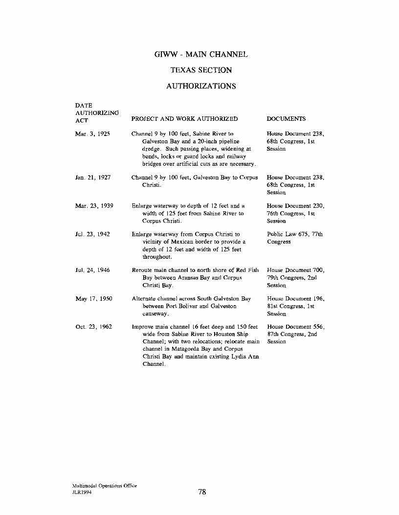
DATE AUTHORIZING ACT
Mar. 3, 1925
Jan. 21, 1927
Mar. 23, 1939
Jul. 23, 1942
Jul. 24, 1946
May 17, 1950
Oct. 23, 1962
GJWW - MAIN CHANNEL
TEXAS SECTION
AUTHORIZATIONS
PROJECT AND WORK AUTHORIZED
Channel 9 by 100 feet, Sabine River to Galveston Bay and a 20-inch pipeline dredge. Such passing places, widening at bends, locks or guard locks and railway bridges over artificial cuts as are necessary.
Channel 9 by 100 feet, Galveston Bay to Corpus Christi.
Enlarge waterway to depth of 12 feet and a width of 125 feet from Sabine River to Corpus Christi.
Enlarge waterway from Corpus Christi to vicinity of Mexican border to provide a depth of 12 feet and width of 125 feet throughout.
Reroute main channel to north shore of Red Fish Bay between Aransas Bay and Corpus Christi Bay.
Alternate channel across South Galveston Bay between Port Bolivar and Galveston causeway.
Improve main channel 16 feet deep and 150 feet wide from Sabine River to Houston Ship Channel; with two relocations; relocate main channel in Matagorda Bay and Corpus Christi Bay and maintain existing Lydia Ann Channel.
\!ultimodal Operations Office JLR1994 78
DOCUMENTS
House Document 238, 68th Congress, 1st Session
House Document 238, 68th Congress, 1st Session
House Document 230, 76th Congress, 1st Session
Public Law 675, 77th Congress
House Document 700, 79th Congress, 2nd Session
House Document 196, 81st Congress, 1st Session
House Document 556, 87th Congress, 2nd Session
Appendix C
THE TEXAS COAST AL WATERWAY ACT OF
1975

!!!!!!!!!!!!!!!!!!!"#$%!&'()!*)&+',)%!'-!$-.)-.$/-'++0!1+'-2!&'()!$-!.#)!/*$($-'+3!
44!5"6!7$1*'*0!8$($.$9'.$/-!")':!
APPENDIX C
Texas Coastal Waterway Act of 1975
Vernon's Annotated Revised Civil Statutes qf the State qf Texas
Volume 15A Landlord and Tenant--Lands, Public
Art. 5415e-2. Coastal Waterway Act of 1975
Short Title
Sec. 1. This Act may be cited as the "Texas Coastal Waterway Act of 1975."
Policy
Sec. 2. It is the policy of the State of Texas (i) to support the marine commerce and economy of this state by providing for the shallow draft navigation of the state's coastal waters in an environmentally sound fashion, and (ii) to prevent waste of both publicly and privately owned natural resources, to prevent or minimize adverse impacts on the environment, and to maintain, preserve, and enhance wildlife and fisheries; and to accomplish such policy the State of Texas shall act as the nonfederal sponsor of the main channel of the Gulf Coast Intracoastal Waterway from the Sabine River to the Brownsville Ship Channel, and shall satisfy the responsibilities of the nonfederal sponsor as determined by federal law consistent with the policy of the State of Texas as declared in this section.
Findings
Sec. 3. The legislature finds and declares that:
(a) Marine commerce is a vital element of the state's economy and the benefits derived therefrom are realized directly or indirectly by the entire state.
(b) The coastal public lands and the coastal marshes and similar coastal areas located on both publicly and privately owned lands are similarly vital elements of the state's economy, and to the maintenance, preservation, and enhancement of the environment, wildlife, and fisheries, the benefits of which are similarly realized directly or indirectly by the entire state.
(c) The coastal public lands and related natural resources constitute a vital asset of the state to be managed for the benefit of all citizens of the State of Texas.
Multimodal Operations Office JLR1994 81
(d) The Gulf Intracoastal Waterway traverses coastal public lands and areas in close proximity to the coastal marshes and similar coastal areas located on both publicly and privately owned lands.
(e) The Gulf Intracoastal Waterway can be maintained, operated, and improved in such a way as to prevent waste of both publicly and privately owned natural resources, that adverse environmental impacts are avoided or minimized, and that in some cases beneficial environmental effects can be realized.
(f) It is in the best interest of all citizens to accomplish the policy of the State of Texas as stated in Section 2 of this Act for the State of Texas to meet the responsibilities as required by federal law of the nonfederal sponsor of the Gulf Intracoastal Waterway.
Definitions
Sec. 4. As used in this chapter:
(a) "Coastal public lands" means all or any portion of the state-owned submerged land, the waters overlying those lands, and all state-owned islands or portions of islands that may be affected by the ebb and flow of the tide.
(b) "Coastal marshes and similar areas" means those soft, low-lying watery or wet lands and drainage areas in the coastal areas of the state which may or may not be subject to the ebb and flow of the tide but which are of ecological significance to the environment and to the maintenance, preservation, and enhancement of wildlife and fisheries.
(c) "Commission" means the State Highway Commission.
(d) "Gulf lntracoastal Waterway" means the main channel, not including tributaries or branches, of the shallow draft navigation channel running from the Sabine River southward along the Texas coast to the Brownsville Ship Channel near Port Isabel that is generally referred to as the Gulf Intracoastal Canal.
(e) "Person" means any individual, firm, partnership, association, corporation (public or private, profi~ or nonprofit), trust, or political subdivision or agency of the state.
Administrative Provisions
Sec. 5. (a) This Act shall be administered by the State Highway Commission.
(b) The provisions of this Act are cumulative of all other Acts relating to the comm1ss1on.
Multimodal Operations Office JLR1994 82
(c) Nothing in this Act shall diminish the duties, powers, and authorities of the School Land Board to manage the coastal public lands of the state.
Duties and Powers
Sec. 6. (a) The commission shall cooperate and work with the Department of the Army, all other appropriate federal and state agencies, navigation districts and port authorities, counties, and other appropriate persons to determine specifically what must be done by the State of Texas to satisfy federal local sponsorship requirements relating to the Gulf Intracoastal Waterway in a manner consistent with the policy of the State of Texas as stated in Section 2 of this Act.
(b) The commission shall fulfill, in a manner consistent with the policy of the state as stated in Section 2 of this Act, the local sponsorship requirements relating to the Gulf Intracoastal Waterway as agent for the state.
(c) Subject to the provisions of Subsection (g) of this section, the commission is authorized to acquire by gift, purchase, or condemnation any property or interest in property of any kind or character deemed necessary by the commission to fulfill its responsibilities under this Act as the nonfederal sponsor of the Gulf Intracoastal Waterway, including but not limited to easements and rights-of-way for dredge material disposal sites and easements and rights-of-way for channel expansion, relocation, or alteration, save and except oil, gas, sulphur, and other minerals of any kind or character which can be recovered without utilizing the surface of any such land for exploration, drilling, or mining purposes. A11 other provisions relating to the exercise of the power of eminent domain sha11 be in accord with the commission's existing powers and authority relating to eminent domain. However, the commission does not have the authority to condemn any submerged public lands under the jurisdiction of the School Land Board.
( d) Proposed actions and actions of the commission pursuant to this Act which have potential for significant environmental impact or effect upon coastal public lands, coastal marshes and similar areas, wildlife, and fisheries shall be coordinated with appropriate state and federal agencies having environmental, wildlife, and fisheries responsibilities.
(e) All agencies and political subdivisions of the State of Texas shall, within their legal authorities and available resources, assist the commission in carrying out the purposes of this Act. All such agencies and political subdivisions are hereby authorized without any form of advertisement to make conveyance of title or rights and easements, owned by any such body, to any property needed by the commission to meet its responsibilities under this Act as the nonfederal sponsor of the Gulf Intracoastal Waterway.
Multimodal Operations Office JLR1994 83
(f) The comm1ss1on, in cooperation with all appropriate persons, shall continually evaluate the Gulf Intracoastal Waterway as it relates to Texas. Such evaluations shall include an assessment of the importance of the Gulf Intracoastal Waterway, including an identification of direct and indirect beneficiaries; identification of principal problems and possible solutions to such problems, including estimated costs, economic benefits, and environmental effects; evaluation of the need for significant modifications to the Gulf Intracoastal Waterway; and specific recommendations for legislative actions that the commission believes to be in the best interest of the state in carrying out the policy of the state as declared in Section 2 of this Act. The results of this evaluation shall be published in a report to be presented to each regular session of the legislature.
(g) Prior to approval or implementation by the commission of any plan or project for acquisition or acquisition of any property or interest in property for any dredge material disposal site, or for the widening, relocation, or alteration of the main channel of the Gulf Intracoastal Waterway which requires the acquisition of any additional property or interest in property, to satisfy federal local sponsor requirements, the commission shall hold public hearings for the purpose of receiving evidence and testimony concerning the desirability of such proposed dredge material disposal site and of any such widening, relocation, or alteration of the main channel of the Gulf Intracoastal Waterway, prior to which hearing the commission shall publish notice of such plan, project, and hearing, at least once a week for three successive weeks in a newspaper of general circulation published in the county seat of each county in which any such proposed dredge material disposal site or part thereof is located and in which the channel or any portion of the channel of the Gulf Intracoastal Waterway to be widened, relocated, or altered is located, of the date, time, and place of such hearing. If after such public hearing the commission shall determine that such proposed dredge material site plan or project or such proposed plan or project for widening, relocation, or alteration of the main channel of the Gulf Intracoastal Waterway, as the case may be, can be accomplished without unjustifiable waste of publicly or privately owned natural resources and without permanent substantial adverse impact on the environment, wildlife, or fisheries, the commission may then, upon its approval of such plan or project, proceed to implement such plan or project and acquire, in such manner as provided in Section 6(c) of this Act, such additional property or interest in property necessary to satisfy federal local sponsorship requirements for implementation of such plans for such dredge material site or for such widening, relocation, or alteration of the Gulf Intracoastal Waterway.
Funding
Sec. 7. The legislature is hereby authorized to appropriate from the General Revenue Fund funds in the amount necessary to accomplish the purposes of this Act.
Acts 1975, 64th Leg., p. 405, ch. 181, eff. Sept. 1, 1975.
Multimodal Operations Office JLR1994 84
Saved from Repeal
This article was expressly savedfrom repeal by art. I, § 2(b) of Acts 1977, 65th Leg., p. 2690, ch. 871, enacting the Natural Resources Code.
Historical and Statutory Notes
Title of Act:
An Act relating to the importance of coastal puhlic lands, the coastal marshes, and similar coastal areas of the state located on both publicly and privately owned lands and the importance of the maintenance, preservation, and enhancement of the environment, wildlife and fisheries, and to the importance of the Gulf Intracoastal Waterway; providing for the administration by the State of Texas for
nonfederal sponsorship requirements for the future maintenance and improvement of the Gulf Intracoastal Waterway consistent with the policy of the State of Texas; prescrihing the powers and duties of the State Highway Department in implementing this Act and of other state agencies and political subdivisions in cooperating with the department; authorizing appropriations for funding; and declaring an emergency. Acts 1975, 64th Leg., p. 405, ch. 181.
Library References
Navigahle Waters 6. C.J.S. Navigable Waters§ 12 et seq.
Multimodal Operations Office JLR1994 85

!!!!!!!!!!!!!!!!!!!"#$%!&'()!*)&+',)%!'-!$-.)-.$/-'++0!1+'-2!&'()!$-!.#)!/*$($-'+3!
44!5"6!7$1*'*0!8$($.$9'.$/-!")':!

BIBLIOGRAPHY

!!!!!!!!!!!!!!!!!!!"#$%!&'()!*)&+',)%!'-!$-.)-.$/-'++0!1+'-2!&'()!$-!.#)!/*$($-'+3!
44!5"6!7$1*'*0!8$($.$9'.$/-!")':!
BIBLIOGRAPHY
A. Works Cited
Data Resources, Inc. The 1982 Estimated Value of Waterborne Commodities. Research Report 84-R-2. Washington, D. C.: For the U. S. Army Corps of Engineers, February 1984.
Kelly, Brigadier General Patrick, Director Civil Works, U. S. Army Corps of Engineers. Speech. Presented at the meeting of the Society of American Military Engineers in Houston, Texas, September 22, 1988.
Laws of the United States Relating to the Improvement of Rivers and Harbors from 1790-1913. Volume 1, (Serial Volume 6396), House Document 1491, 62nd Congress. Washington, D. C.: Government Printing Office, 1913.
Miloy, John and Christian Phillips. Primary Economic Impact of the Gulf Intracoastal Waterway in Texas. TAMU-SG-74-221. College Station, Texas: Texas A & M University Industrial Economics Research Division Sea Grant Program, 197 4.
Office of Technology Assessment. Transportation of Hazardous Materials. Washington, D. C.: United States Congress, July 1986.
Osburn, Hal R.; Gary E. Saul; and C. L. Hamilton. Trends in Texas Commercial Fishery Landings, 1977-1993. Management Data Series Number 107. Austin, Texas: Texas Parks and Wildlife Department, Coastal Fisheries Branch, 1994.
Roop, Stephen S.; Daryl U. Wang; Richard W. Dickinson; and Gordon M. Clarke. Closure of the GIWW and its Impact on the Texas Highway Transportation System. Research Report 1283-2F. College Station, Texas: Texas Transportation Institute, 1993.
Texas Coastal Waterway Act of 1975 - Texas Civil Statutes, Article 5415e-2.
Texas State Department of Highways and Public Transportation (now the Texas Department of Transportation). The Gulf Intracoastal Waterway, 1976. Austin, Texas: State Department of Highways and Public Transportation, 1976.
Texas State Department of Highways and Public Transportation (now the Texas Department of Transportation). The Gulf Intracoastal Waterway, 1982. Austin, Texas: State Department of Highways and Public Transportation, 1982.
Multimodal Operations Office JLR1994 89
United States Army Corps of Engineers, Galveston District. Gulf Intracoastal Waterway (Section 216 Study) Sargent Beach, Texas Feasibility Report and Final Environmental Impact Statement. Galveston, Texas: February, 1992.
United States Army Corps of Engineers. MV-GC Region Freight Traffic Tables, CY 1992: Advanced Information. Waterways and Harbors - Gulf Coast, Mississippi River System and Antilles, Part 2. New Orleans, Louisiana: Waterborne Commerce Statistics Center, 1994.
United States Army Corps of Engineers. Waterborne Commerce of the United States. National Summaries, Part 5. New Orleans, Louisiana: Waterborne Commerce Statistics Center, 1994.
Multimodal Operations Office JLRl994 90
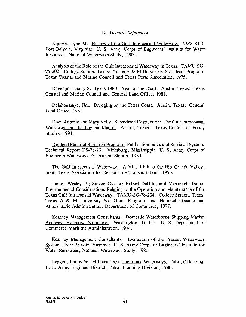
B. General References
Alperin, Lynn M. History of the Gulf Intracoastal Waterway. NWS-83-9. Fort Belvoir, Virginia: U. S. Army Corps of Engineers' Institute for Water Resources, National Waterways Study, 1983.
Analysis of the Role of the Gulf Intracoastal Waterway in Texas. TAMU-SG-75-202. College Station, Texas: Texas A & M University Sea Grant Program, Texas Coastal and Marine Council and Texas Ports Association, 1975.
Davenport, Sally S. Texas 1980: Year of the Coast. Austin, Texas: Texas Coastal and Marine Council and General Land Office, 1981.
Delahoussaye, Jim. Dredging on the Texas Coast. Austin, Texas: General Land Office, 1981.
Diaz, Antonio and Mary Kelly. Subsidized Destruction: The Gulf Intracoastal Waterway and the Laguna Madre. Austin, Texas: Texas Center for Policy Studies, 1994.
Dredged Material Research Program. Publication Index and Retrieval System, Technical Report DS-78-23. Vicksburg, Mississippi: U. S. Army Corps of Engineers Waterways Experiment Station, 1980.
The Gulf Intracoastal Waterway: A Vital Link to the Rio Grande Valley. South Texas Association for Responsible Transportation. 1993.
James, Wesley P.; Steven Giesler; Robert DeOtte; and Masamichi Inoue. Environmental Considerations Relating to the Operation and Maintenance of the Texas Gulf Intracoastal Waterway. TAMU-SG-78-204. College Station, Texas: Texas A & M University Sea Grant Program, and National Oceanic and Atmospheric Administration, Department of Commerce, 1977.
Kearney Management Consultants. Domestic Waterborne Shipping Market Analysis, Executive Summary. Washington, D. C.: U. S. Department of Commerce Maritime Administration, 1974.
Kearney Management Consultants. Evaluation of the Present Waterways System. Fort Belvoir, Virginia: U. S. Army Corps of Engineers' Institute for Water Resources, National Waterways Study, 1981.
Leggett, Jimmy W. Military Use of the Inland Waterways. Tulsa, Oklahoma: U. S. Army Engineer District, Tulsa, Planning Division, 1986.
Multimodal Operations Office JLR1994 91
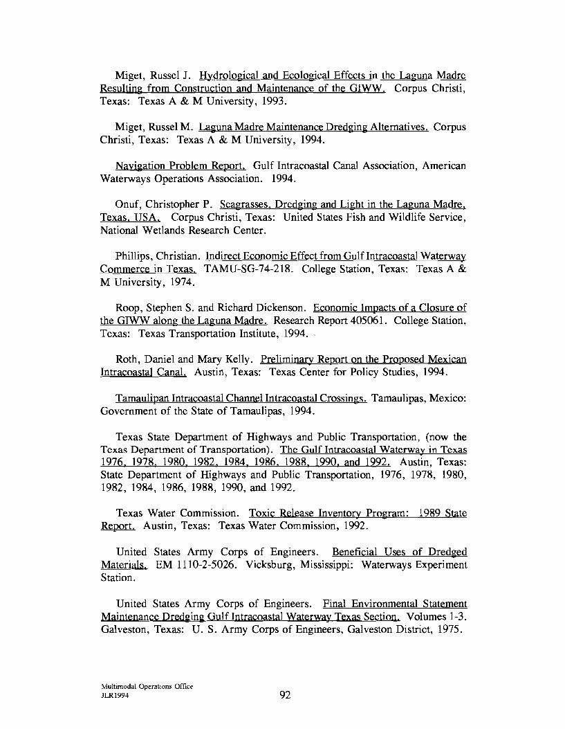
Miget, Russel J. Hydrological and Ecological Effects in the Laguna Madre Resulting from Construction and Maintenance of the GIWW. Corpus Christi, Texas: Texas A & M University, 1993.
Miget, Russel M. Laguna Madre Maintenance Dredging Alternatives. Corpus Christi, Texas: Texas A & M University, 1994.
Navigation Problem Report. Gulf Intracoastal Canal Association, American Waterways Operations Association. 1994.
Onuf, Christopher P. Seagrasses, Dredging and Light in the Laguna Madre, Texas, USA. Corpus Christi, Texas: United States Fish and Wildlife Service, National Wetlands Research Center.
Phillips, Christian. Indirect Economic Effect from Gulflntracoastal Waterway Commerce in Texas. TAMU-SG-74-218. College Station, Texas: Texas A & M University, 1974.
Roop, Stephen S. and Richard Dickenson. Economic Impacts of a Closure of the GIWW along the Laguna Madre. Research Report 405061. College Station, Texas: Texas Transportation Institute, 1994.
Roth, Daniel and Mary Kelly. Preliminary Report on the Proposed Mexican Intracoastal Canal. Austin, Texas: Texas Center for Policy Studies, 1994.
Tamaulipan lntracoastal Channel Intracoastal Crossings. Tamaulipas, Mexico: Government of the State of Tamaulipas, 1994.
Texas State Department of Highways and Public Transportation, (now the Texas Department of Transportation). The Gulf Intracoastal Waterway in Texas 1976, 1978, 1980, 1982, 1984, 1986, 1988, 1990, and 1992. Austin, Texas: State Department of Highways and Public Transportation, 1976, 1978, 1980, 1982, 1984, 1986, 1988, 1990, and 1992.
Texas Water Commission. Toxic Release Inventory Program: 1989 State Report. Austin, Texas: Texas Water Commission, 1992.
United States Army Corps of Engineers. Beneficial Uses of Dred~ed Materials. EM 1110-2-5026. Vicksburg, Mississippi: Waterways Experiment Station.
United States Army Corps of Engineers. Final Environmental Statement Maintenance Dred~in~ Gulf Intracoastal Waterway Texas Section. Volumes 1-3. Galveston, Texas: U. S. Army Corps of Engineers, Galveston District, 1975.
l'vlultimodal Operations Office JLR1994 92

United Stats Army Corps of Engineers. In the Era of Limits: A Galveston District History Update, 1976-1986. Galveston, Texas: U.S. Army Corps of Engineers, Galveston District, 1990.
United States Army Corps of Engineers. Water Resource Development in Texas. Galveston, Texas: U.S. Army Corps of Engineers, 1991.
Multimodal Operations Office JLR1994 93