The following was presented at DMT’10 DMT’10 Proceedings ...
29
DMT 2009 The following was presented at DMT’10 (May 16-19, 2010). The contents are provisional and will be superseded by a paper in the DMT’10 Proceedings. See also earlier Proceedings (1997-2009) http: //ngmdb . usgs .gov/info/dmt/
Transcript of The following was presented at DMT’10 DMT’10 Proceedings ...

DMT 2009
The following was presented at DMT’10(May 16-19, 2010).
The contents are provisional and will besuperseded by a paper in the
DMT’10 Proceedings.
See also earlier Proceedings (1997-2009)http://ngmdb.usgs.gov/info/dmt/

Building a surficial geology data model
for mapping projects
Christine Deblonde (Geological Survey of Canada)

Outline
Context
Mapped features
Geodatabase
Next steps
Building a surficial geology data model for mapping projects DMT 2010

Context
Geological Map Flow Project
Compilation, interpretation, management anddissemination of geologic map information
Data collection –> Data management -> Datadissemination
Surficial geology data
Data model is implemented as an ESRI™ArcGIS geodatabase
Building a surficial geology data model for mapping projects DMT 2010

Mapped features
What is being mapped?
How is it described?
How is it implemented?
Building a surficial geology data model for mapping projects DMT 2010

Mapped features
What is being mapped?Map units
Landforms and geomorphologicfeatures
Field observations andmeasurements
How is it described?
Science language, symbol, legend
How is it implemented?
Data structure
Building a surficial geology data model for mapping projects DMT 2010

Mapped features
Building a surficial geology data model for mapping projects DMT 2010
What is being mapped?Map units
Landforms and geomorphologicfeatures
Field observations andmeasurements
How is it described?
Science language, legend, symbol
How is it implemented?
Data structure

What is being mapped?Map units
Landforms and geomorphologicfeatures
Field observations andmeasurements
How is it described?
Science language, symbol, legend
How is it implemented?
Data structure
Mapped features
Building a surficial geology data model for mapping projects DMT 2010
Science language development
Review of existing data models and mapping products
2 science champions
Small working group
Iterative consultations with surficial geology mapping experts
Developed for mapped features and field data collection

Mapped features
What is being mapped?
Map units
Landforms and geomorphologicfeatures
Field observations andmeasurements
How is it described?
Science language, symbol, legend
How is it implemented?
Data structure
Building a surficial geology data model for mapping projects DMT 2010

Mapped featuresMap units
Compilation of surficial legends (by H. Thorleifsonand M. Pyne (2002)
1578 maps;
Map units: 2431 different codes
Symbols: 5423 different definitions
Building a surficial geology data model for mapping projects DMT 2010

Mapped featuresMap units
Building a surficial geology data model for mapping projects DMT 2010

Mapped featuresMap units
Genesis: process and environment of depostion Category:
Morphology,stratigraphy, thickness, secondary process
Geologic event
Legend
Building a surficial geology data model for mapping projects DMT 2010
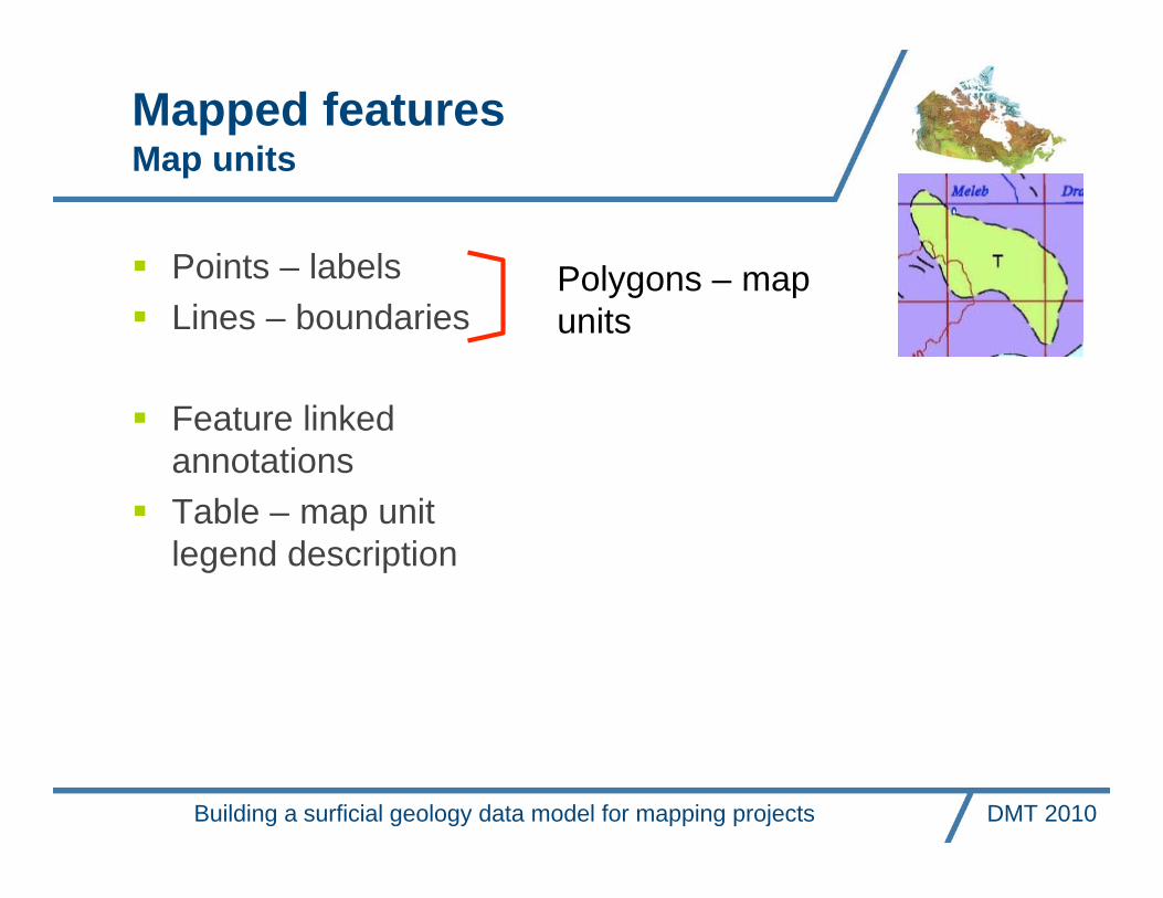
Mapped featuresMap units
Points – labels
Lines – boundaries
Feature linkedannotations
Table – map unitlegend description
Building a surficial geology data model for mapping projects DMT 2010
Polygons – mapunits

Map unit boundary
Mapped featuresLandforms and geomorphologic features
features as zones
features as points
features as lines
Compilation of surficiallegends (by H. Thorleifsonand M. Pyne (2002)
1578 maps;
Map units: 2431different codes
Symbols: 5423different definitions
e.g. Esker - more than50 different ways todescribe the direction offlow
Building a surficial geology data model for mapping projects DMT 2010

Mapped featuresLandforms and geomorphologic features
What features (concepts) are portrayed?
…
Building a surficial geology data model for mapping projects DMT 2010

Mapped featuresLandforms and geomorphologic features
…
What geometry?
Building a surficial geology data model for mapping projects DMT 2010

Mapped featuresLandforms and geomorphologic features
What is the most significant attribute? subfeatures
What other fields do we need? and what goes inthem?
How is it symbolized?
Building a surficial geology data model for mapping projects DMT 2010
Field observations
and measurements
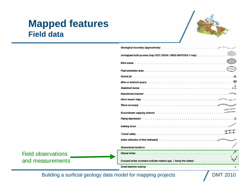
Mapped featuresField data
Building a surficial geology data model for mapping projects DMT 2010

Mapped featuresField data
Field observations and measurementsTraverse
Station - Station environment
Photo
Earth material description
Samples
Paleoflow measurements
Structural measurements
Preliminary linework
GanFeld application
Building a surficial geology data model for mapping projects DMT 2010

Mapped featuresField data
Field observations and measurements
Points (station)
Lines (traverse, preliminary linework)
Tables
Relationship classes
Building a surficial geology data model for mapping projects DMT 2010

Geodatabase
Mapped features
Feature classes
Data tables
Metadata tables
Relationship ClassesControls
Domains
Subtypes
Rules
Tools
Building a surficial geology data model for mapping projects DMT 2010

Geodatabase
Mapped features
Feature classes
Data tables
Metadata tables
Relationship ClassesControls
Subtypes
Domains
Rules
Tools
Science language is maintained in aseparate database
Unique sequential number forsubtype and domain values
Some domains are projectspecific
Building a surficial geology data model for mapping projects DMT 2010

Geodatabase
Mapped features
Feature classes
Data tables
Metadata tables
Relationship ClassesControls
Subtypes
Domains
Rules
Tools
Building a surficial geology data model for mapping projects DMT 2010

Geodatabase
Mapped features
Feature classes
Data tables
Metadata tables
Relationship ClassesControls
Subtypes
Domains
Rules
Tools
Building a surficial geology data model for mapping projects DMT 2010

Geodatabase
Mapped features
Feature classes
Data tables
Metadata tables
Relationship ClassesControls
Subtypes
Domains
Rules
Tools
Building a surficial geology data model for mapping projects DMT 2010

Geodatabase
Mapped features
Feature classes
Data tables
Metadata tables
Relationship ClassesControls
Subtypes
Domains
Rules
Tools
Building a surficial geology data model for mapping projects DMT 2010
Next steps
Science language review committeeTools, rules (topology, tolerance)Publication of science language and geodatabase schemaCookbook and trainingTesting Science language by loading maps from:
A preliminary version in a personal GDBCoveragesCompilations
ArcSDE implementation
Building a surficial geology data model for mapping projects DMT 2010

Participants
Science language working group
Christine Deblonde, Serge Paradis, Daniel Kerr, PeterDavenport, Andy Moore, Éric Boisvert
GanFeld application and tool development team
Guy Buller, Kaz Shimamura, Stephen Williams, PierreBrouillette, Étienne Girard, Gabriel Huot-Vézina, Patty Zhao
Contributors
Rod Smith, Michel Parent, Alejandra Duk-Rodkin, DavidHuntley, Alain Plouffe, Art Dyke, Isabelle McMartin, JanetCampbell, Dave Sharpe, Ruth Boivin, Larry MacDonald,Doug Lemay, Graham Lai, Felice Hardjowirogo, Vic Dohar,Dave Everett
Building a surficial geology data model for mapping projects DMT 2010

Questions?