Healthwatch Croydon GP Patient Experience of Croydon Residents 01.07.14 to 30.06.15
The Fair Field
MasTerplan
Make archiTecTs kinnear landscape archiTecTs
Wsp aecoM
arcadis

TeaM sTakeholder Board
Make croYdon coUncil Greg Willis Finn Williams david patterson Mike kiely richard Meddings priscilla holness
ian plowright kla catherine radziwonik lynn kinnear Vincent lacovara Florence Moon david carlisle
lisa Mccance Wsp ken dryden david ellis Guy protheroe
aecoM ccUrV pierre klemas duncan Brisbane Jon leach nick Wood Julian king
croYdon colleGe arcadis phil coulthard paul shrimpton John Fosbraey stuart Waite chay champness
acknoWledGe MenTs FairField halls TrUsTees Thanks to: simon Thomsett Gehl John Bartliff keith Williams architects stuart labram First Base croydon local studies library and Terrace hill archives service Ben rodgers The imagine Group croydon college MeTropoliTan properTY
andrew Thompson
MaGisTraTes coUrT (hMcs) paul hazell
BridGeWaTer/GroVeBank properTies Mark hus laurence Quail Tim Waller
TFl colin Mann rhiannon parrett alex andrews Jessica ellery
ncp courtney hindle
neTWork rail robert sue
i

conTenTs
1.0 ForeWord 01
2.0 seTTinG The scene 05 2.1 The Bigger picture 06 2.2 role of the Masterplan 08 2.3 historic context 12 2.4 Fair Field Today 14 2.5 constraints 16 2.6 opportunities 18 2.7 agreed objectives 20 2.8 public engagement 22 2.9 open space context 28 2.10 policy context 29
3.0 The MasTerplan 31 3.1 a deliverable plan 32 3.2 public realm parameters
- street level 36 - Below Ground 38 - public realm palette 40 - lighting, safety and security 42
-Landscape,Wayfindingand Biodiversity 44
3.3 development parameters - street level 46 - Below Ground 48 - illustrative shadow studies 50
3.4 Movement parameters - street level 52 - Below Ground 55
3.5 phasing: now 56 3.6 phasing: soon 57 3.7 phasing: later 58 3.8 character areas 59 3.9 character description 60
4.0 The coMponenTs 69 4.1 introduction to the components 70 FF1 suffolk house site 74 FF2 st. Matthews house site 76 FF3 essex house site 78 FF4 college road 80 FF5 George street Walk 81 FF6 college square 82 FF7 Mondial site 84 FF8 east college site 86 FF9 substation 88 FF10 hazledean link 89 FF11 station link 90 FF12 croydon college perimeter 92 FF13 croydon college Walk 93 FF14 park lane square 94 FF15 college Green West 95
FF16 college Green east 96 FF17 park lane Walk 97 FF18FairfieldForecourt 98 FF19FairfieldHalls 99 FF20 service Yard 100 FF21FairfieldWalk 101 FF22 Barclay road development n. 102 FF23 Barclay road development s. 104 FF24 carpark ramp 106 FF25 Barclay road Walk 107
5.0 nexT sTeps 109 5.1 early Wins 110
ii

suffolk house
east croydon
station
st. Matthews
house and aiG
Former
essexhouse
site
Mondial h ouse
college road
p ark l ane
croydon
college
Barclayroad
annexe
college
Green Multistorey
car park
Magistrates
court
Barclay road
Fairfield
halls
aerial view highlighting The Fair Field Masterplan area.
iii

1.0
ForeWord
1

1.1 ForeWord
1.1.1 croydon is unique. From major market town and residence of the archbishops of canterbury to dynamic Victorian county Borough and booming 60s commercial centre, a strong sense of civic identity and aspiration runs through croydon’s history. croydon’s potential lies somewhere between its twin roles as a leading sub-centre of outer London,andasignificantand ambitious Metropolitan centre in its own right. croydon’s vision is to be recognised as london’s most enterprising borough – a place that offers rare opportunities as a focus for growth in one of the world’s great cities.
1.1.2 croydon already has all the right ingredients. it is london’s biggest borough and has the biggest youth population in london. it is one of the top retail and commercial centres in london and provides one of the greatest ranges of homes; from low density suburbs to the south of the borough to higher density urban areas to the north. a borough made up of lots of interrelated places, each with its own distinct character, one third of croydon’s area is green space. croydon also boasts some of the best transport connections in the Uk, with london’s only tram system, rail connections from east croydon station that take you to central london in 15 minutes and Gatwick in 20 minutes, and new connections to the east london line/ london overground at West croydon.
1.1.3 Within this context, croydon Metropolitan centre (cMc) in particular offers huge potential for positivechange,withsignificant
capacity for thousands of new homes, businesses, community facilities and a radically transformed public realm with new squares, streets and green spaces. change on the scale required needs clear leadership, a shared vision, a collaborative approach and a focus on delivery. This document is one of a series of masterplans that do just that.
1.1.4 developed in collaboration with our partners, croydon’s Metropolitan centre masterplans provide a clear vision that will generate shared enthusiasm and confidencebut,moreimportantly, they are all about delivery. These coordinated masterplans provide arobustframeworkforsignificant positive change in cMc over the coming years, and open up exciting new opportunities for involvement and investment that willbenefitallthosewhochooseto live, work or play in the Borough.
1.1.5 and we have already started. as a direct result of croydon’s innovative masterplanning process, we are working with network rail and having secured fundingtodeliversignificant improvements at east croydon station, work is now on site. We are working with the Mayor to deliver the connected croydon programme of public realm projects. and we are working with our development partners John laing as part of our ground-breaking croydon Urban regeneration Vehicle (ccUrV) to take the lead in getting development rolling in the Metropolitan centre. construction oftheCouncil’snewoffices, Bernard Weatherill house, is nearing completion.
1.1.6 With the completion of these masterplans, we are at the beginning of an exciting decade of collaboration and delivery.
councillor Jason perry cabinet Member for planning, regeneration & Transport, croydon council
2

View looking west over college Green, 2010
3
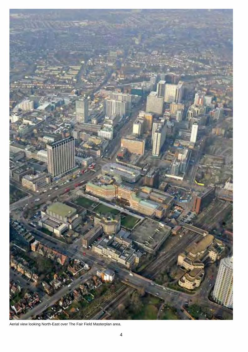
aerial view looking north-east over The Fair Field Masterplan area.
4

2.0
seTTinG The scene
5
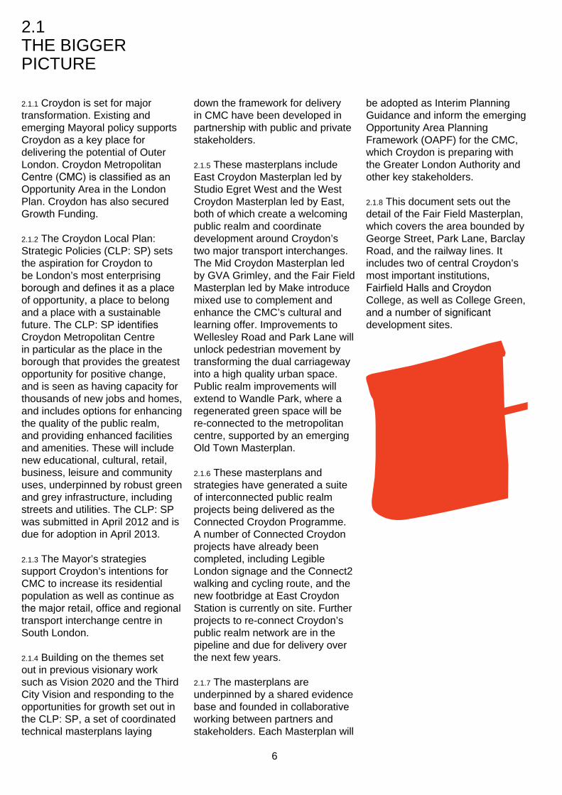
2.1 The BiGGer picTUre
2.1.1 croydon is set for major transformation. existing and emerging Mayoral policy supports croydon as a key place for delivering the potential of outer london. croydon Metropolitan Centre(CMC)isclassifiedasan opportunity area in the london plan. croydon has also secured Growth Funding.
2.1.2 The croydon local plan: strategic policies (clp: sp) sets the aspiration for croydon to be london’s most enterprising boroughanddefinesitasaplace of opportunity, a place to belong and a place with a sustainable future. The clp: spidentifies croydon Metropolitan centre in particular as the place in the borough that provides the greatest opportunity for positive change, and is seen as having capacity for thousands of new jobs and homes, and includes options for enhancing the quality of the public realm, and providing enhanced facilities and amenities. These will include new educational, cultural, retail, business, leisure and community uses, underpinned by robust green and grey infrastructure, including streets and utilities. The clp: sp was submitted in april 2012 and is due for adoption in april 2013.
2.1.3 The Mayor’s strategies support croydon’s intentions for cMc to increase its residential population as well as continue as themajorretail,officeandregional transport interchange centre in south london.
2.1.4 Building on the themes set out in previous visionary work such as Vision 2020 and the Third city Vision and responding to the opportunities for growth set out in the clp: sp, a set of coordinated technical masterplans laying
down the framework for delivery in cMc have been developed in partnership with public and private stakeholders.
2.1.5 These masterplans include east croydon Masterplan led by studio egret West and the West croydon Masterplan led by east, both of which create a welcoming public realm and coordinate development around croydon’s two major transport interchanges. The Mid croydon Masterplan led by GVa Grimley, and the Fair Field Masterplan led by Make introduce mixed use to complement and enhance the cMc’s cultural and learning offer. improvements to Wellesley road and park lane will unlock pedestrian movement by transforming the dual carriageway into a high quality urban space. public realm improvements will extend to Wandle park, where a regenerated green space will be re-connected to the metropolitan centre, supported by an emerging old Town Masterplan.
2.1.6 These masterplans and strategies have generated a suite of interconnected public realm projects being delivered as the connected croydon programme. a number of connected croydon projects have already been completed, including legible london signage and the connect2 walking and cycling route, and the new footbridge at east croydon station is currently on site. Further projects to re-connect croydon’s public realm network are in the pipeline and due for delivery over the next few years.
2.1.7 The masterplans are underpinned by a shared evidence base and founded in collaborative working between partners and stakeholders. each Masterplan will
be adopted as interim planning Guidance and inform the emerging opportunity area planning Framework (oapF) for the cMc, which croydon is preparing with the Greater london authority and other key stakeholders.
2.1.8 This document sets out the detail of the Fair Field Masterplan, which covers the area bounded by George street, park lane, Barclay road, and the railway lines. it includes two of central croydon’s most important institutions, FairfieldHallsandCroydon college, as well as college Green, andanumberofsignificant development sites.
6

The Fair Field Masterplan in the context of the other croydon masterplans and opportunity area planning Framework
7

2.2 role oF The MasTerplan
2.2.1 The Fair Field was croydon’s the transformation of the area. historic venue for entertainment crucially, it also includes proposals and social activity, hosting fairs, for making change happen now. markets and performances until the arrival of the railways in the 2.2.6 The Fair Field Masterplan is 1860s. But since redevelopment the result of a careful collaborative as college Green in the 1960s process, guided by croydon the area has become increasingly council and involving key disconnected from the rest of the stakeholders in the area through town centre. the Fair Field stakeholder Board,
formed in october 2011. The 2.2.2 The Fair Field area holds huge stakeholder Board comprises potential; two of croydon’s most key landowners, institutions and importantinstitutions,Fairfield statutory organisations with an halls and croydon college, as interest in the area: well as the open space of college Greenandanumberofsignificant • croydon council development sites. The purpose • Bridgewater property / Mondial of the Fair Field Masterplan is • ccUrV to realise that potential, and • croydon college rediscover the area’s role as the • FairfieldHallsTrustees cultural destination in croydon and • Magistrates court south london. • Metropolitan property /
Freshwater 2.2.3 The Fair Field area has the • network rail potential to be croydon’s cultural • ncp and learning centre; an innovative • Terrace hill / chroma and inspiring area with a lively • Transport for london and sustainable mix of residential, cultural, educational, commercial uses and a well-connected and high quality public realm.
2.2.4 The coordinated transformation of the Fair Field area is fundamental to the success of croydon Metropolitan centre and the borough as a whole. These aspirations support the enterprising city and learning city themes and general objective of nurturing innovation set out in the borough vision and clp: sp.
2.2.5 Thisisnotthefirsttime proposals have been made for the Fair Field area – which is why it is important this is not simply ‘yet another plan’. The Fair Field Masterplan provides a phased long-term framework for delivering
keY To land oWnerships:
FairField MUlTi-sToreY car park croydon council, operated by ncp
colleGe Green and UrBan realM croydon council
FairField halls CroydonCouncilandtheFairfield Trust
croYdon colleGe (with planning consent for a 29-storey tower to the east of the existing building)
BarclaY road annexe croydon college
MaGisTraTes coUrT hMcs
sUFFolk hoUse Metropolitan properties (provincial) limited
sT MaTTheWs hoUse and aiG Metropolitan properties (investments) limited
essex hoUse siTe (with planning consentfora17-storeyoffice building) Terrace hill (croydon) limited
Mondial hoUse Bridgewater properties limited
exisTinG sUBsTaTion Uk power networks
car park access BridGe network rail
8

George street
p ark l ane
Barclay road
college road
east croydon
station
GroundfloorplanshowinglandownerswithintheFairFieldMasterplan
9

2.2.7 croydon council and its 2.2.8 The Fair Field Masterplan partners on the stakeholder Board includes a substantial believe that the way to make the subterranean area, which sits most of the opportunities that Fair adjacent to the Wellesley road Field offers - and to transform it in underpass and underground to the fantastic place that it could parking at st. George’s Walk. be - is to develop a Masterplan ownership boundaries vary at consisting of: different levels, meaning strategic
sites need to be understood in • a shared Vision; developed and three dimensions.
agreed with stakeholders and the public 2.2.9 a multi-disciplinary team led
• strategic objectives; clear, by Make and kinnear landscape concise, spatial moves architects was appointed in underpinning the Masterplan January 2012 to develop the
• public realm parameters; to Masterplan. transform the area’s public realmatbothgroundfloor and subterranean levels, in compliance with croydon’s emerging public realm design Guide
• Movement parameters; for all modes of transport, in coordination with wider transport modelling and strategies for central croydon.
• development parameters; guiding development and inspiringconfidenceand certainty
• a robust implementation and phasing strategy; realistic, viableandflexibleframework for delivery in the short, medium and long-term
• character areas; setting the quality, tone and use of different areas within the Masterplan
• a series of components; the Masterplan broken down into a comprehensive set of independently deliverable projects with clear costs and responsibilities
• supported in parallel by a suite of early Wins; detailed designs for a prioritised set of public realm projects that are ready-to-tender and implement.
keY To land oWnerships:
FairField MUlTi-sToreY car park croydon council, operated by ncp
FairField halls CroydonCouncilandtheFairfield Trust
croYdon colleGe (with planning consent for a 29-storey tower to the east of the existing building)
BarclaY road annexe croydon college
Mondial hoUse Metropolitan properties (provincial) limited
exisTinG sUBsTaTion Uk power networks
10

Below ground plan showing landowners within the Fair Field Masterplan
11

2.3 hisToric conTexT
2.3.1 The Fair Field was historically a lively open space and a regional destination for fairs, markets, and entertainment. The arrival of the railways in 1868, widening of park lane, and subsequent comprehensive redevelopment in the mid-20th century resulted in the area becoming increasingly disconnected from the rest of the town centre. The Masterplan aims to rediscover Fair Field’s historic role as a thriving regional destination for the 21st century.
2.3.2 in the context of the modern world, which provides so many different and easy ways to travel andcommunicate,itisdifficult to appreciate the importance of croydon’s fairs and markets and the physical impact they had on the town and its citizens. Throughout the year these fairs were the largest in the county and attracted thousands of people from a broad cross section of society, including many visitors from central london.
2.3.3 From early medieval times the fairs and markets gave isolated rural developments the opportunity to buy and sell goods which were unavailable in the smaller towns and villages. in addition the fairs provided a forum for entertainment and social engagement between diverse communities. By the 18th century the fairs were places where fashionable london society gathered.
‘The town was a fair of itself, music, singing, acrobats, and all kinds of entertainments going on in the street....’1
2.3.4 For over four hundred years croydon’s fairs were held at Fair Field. The arrival of the 1 Mr William page remembering the fair in the 1850s
CroydonFairatFairfield,2October1833
12

Landmark Historical Mapcounty: sUrreYpublished date(s): 1934-1935originally plotted at: 1:2,500
railway in the mid 19th century began to transform the character ofFairfield.Whatwasoncea multi-use, green open space, linked to the town centre by the ancient Fair Field footpath running from park hill to the junction of park lane and George street, became separated from the town centre by the widening of park lane. The resulting pedestrian network offered few options, and reduced access to the new public space of college Green. This is demonstrated by the rapid decline of college Green, which replaced
Fair Field as a public gathering space in the town centre.
2.3.5 Today college Green has sporadic use, proving popular with both students and skateboarders but failing to attract a broader cross section of the local community.
2.3.6 This masterplan proposes a number of strategies which aim to redress this situation and recapture the vibrancy of Fair Field when it was a popular and lively destination.
1880s. View from park lane, near the junction at George street looking east.
early 1900. The area south of Fair Field path was still used for recreation
1940s. Fair Field with the railway gone. The site becomes a car park.
1945. Ve celebrations in Fair Field
1960s. on completion college green was separated from Queen’s Gardens by the widening of park lane
1935 plan of the Fair Field site when it was used for fairs
1935 plan of the Fair Field site as a railway depot
13

2.4 Fair Field TodaY
challenGes opporTUniTies
The pedestrian route is complex, convoluted and perceived as unsafe.
croydon college is a dynamic and thriving educational institution.
Barriers and other obstacles make it impossible to cross the road at street level.
FairfieldHall’siscelebrating50yearsof amazing performances.
pedestrian crossings are poor quality and uninviting.Theenvironmentisdefinedby the predominant use of tarmac.
The bustling croydon city centre is only minutes away from the Fair Field site once across park lane.
Many connections to the site are underground through the carpark.
The central location means that the site is already connected to beautiful and interesting parts of croydon.
14

George street
suffolk house
east croydon
station
st Matthews
house and aiG
Former
essex
house
site
college road
p ark l ane
park lane
Wellesley r
oad
croydon
college
college
Green
Barclay
road
annexe
Multistorey
car park
Magistrates
court
Barclay road
Fairfield
halls
Mondial house
The Queens Gardens
existing plan of the Fair Field Masterplan site, 2012
15

2.5 consTrainTs
an isolaTed and inaccessiBle area
2.5.1 The Fair Field Masterplan area is physically disconnected from the rest of croydon. Because of this there is very little pedestrian activity and consequently minimal public life.
2.5.2 accessiBiliTY
• The Fair Field area is an isolated quarter surrounded by barriers.
• There are few possibilities to walk through college Green.
2.5.3 leVels
• The Fair Field area is perceived as complex and unsafe due to several differences in levels and underpasses.
• it is an inhospitable and incoherent environment for pedestrians due to inconsistent material treatments and lack of legibility.
2.5.4 acTiViTY
• The Fair Field area suffers from a lack of genuine active frontage discourages pedestrians to use the spaces as either route or destination.
• There are few opportunities to cross the roads, primarily due to barriers and other physical obstructions.
• Inparticular,trafficbarriers along park lane, George street and Barclay road do not encourage pedestrian movement. Where these crossings exist they are uninviting and indirect.
constraint: accessibility
constraint: levels
constraint: activity
public access
semi-public access
lower
Ground
raised
active frontage
inactive frontage
Barriers
16
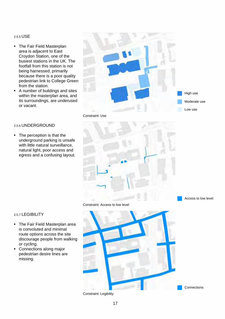
2.5.5 Use
• The Fair Field Masterplan area is adjacent to east croydon station, one of the busiest stations in the Uk. The footfall from this station is not being harnessed, primarily because there is a poor quality pedestrian link to college Green from the station.
• a number of buildings and sites within the masterplan area, and its surroundings, are underused or vacant.
2.5.6 UnderGroUnd
• The perception is that the underground parking is unsafe with little natural surveillance, natural light, poor access and egress and a confusing layout.
2.5.7 leGiBiliTY
• The Fair Field Masterplan area is convoluted and minimal route options across the site discourage people from walking or cycling.
• connections along major pedestrian desire lines are missing.
constraint: Use
constraint: access to low level
constraint: legibility
high use
Moderate use
low use
access to low level
connections
17
2.6 opporTUniTies
a connecTed and accessiBle area
2.6.1 accessiBiliTY
• creating a new link to college Green from east croydon station and at grade crossings on park lane provides the vital missing links along a major pedestrian desire line from east croydon station to the town hall and civic centre.
2.6.2 leVels
• removing multiple stepped level differences across the masterplan area creates a number of key routes that intersect within the Masterplan area, creating concentrated areas of activity. These are places where public spaces will be created.
• The Masterplan seeks to reinforce many existing but poorly realised connections, such as that to Queen’s Gardens.
2.6.3 acTiViTY
• removing barriers and obstructions across the Masterplan area creates increase active frontage. Therefore providing opportunities to enliven routes and create destinations as well as engage more fully with the unique cultural institutions already present in the college andFairfieldHalls.
opportunity: accessibility
opportunity: levels
opportunity: activity
public access
semi-public access
lower
Ground
raised
active frontage
inactive frontage
Barriers
18
2.6.4 Use
• increasing accessibility, legibility and activity allows for the enhanced potential of the redevelopment sites (in orange), creating the opportunity for further connections to be created to the south.
• a more inviting pedestrian route visible from east croydon station will capitalise on the significantpedestriantraffic.
• college Green will become a much busier place as people move to key destinations within croydon. This will act as a catalyst for redevelopment within the masterplan area.
2.6.5 UnderGroUnd
• Brighter, safer and more legible connectivity between the podium level and the car park below is essential for re-ordering people’s perspective of the area.
2.6.6 leGiBiliTY
• a number of key pedestrian links sit outside the boundary, but they are critical to its success in order to create thenecessaryflowofpeople through the area.
opportunity: Use
opportunity: access to low level
opportunity: legibility
high use
new development opportunities
Reconfigured access to low level
connections
19
LIFE
SPACE
BUILDINGS
1. LIFE. De grå stiplede cirkler kommer frem en efter en og illustrerer de forskellige brugergrupper. Menneskerne bevæger sig langs gang-linerne.Overgangene mellem life space buildings skal være tydlige....
2. SPACE. “Rummet” kommer på - grønt område og multifunktio-nelt bymøbel. Menneskene bevæger sig stadig.... skateren kan ‘glide’ på rampen.....
3. BUILDINGS. Bygningerne kommer på. Der kommer lys ud af vinduerne / ved cafeen og andre stederballongyngerne kører evt rundt....Menneskene bevæger sig stadig....
Det der skal fremhæves i animationen:
2.7 aGreed oBJecTiVes
2.7.1 six opportunities have been identifiedbytheStakeholder Board to deliver the vision, which underpin all recommendations and proposals set out in this Masterplan.
a desTinaTion
2.7.2 a regional destination anchoredbysignificantinstitutions thatcontributetoandbenefitfrom their surroundings.
sTronG pUBlic realM
2.7.3 an animated, and well-used public realm that complements surrounding spaces.
an acTiVe space
2.7.4 a vital mix of activities giving opportunities for local enterprise.
20

The holistic mobility plan in support of public life
pedestrian movement & public space network
bicycling
public transportation
vehicular traffic & parking
- Putting people and city life in the
centre of planning
- Informing priorities between the
different modes of transportation
- Ensuring integration between
different modes of transportation
- Providing a holistic framework
integrating the different masterplans
P
P
P12 34
12 34
More connecTed
2.7.5 Better connections to and through the Masterplan area.
neW deVelopMenT
2.7.6 optimised development potential to enable a new mix of uses.
a realisTic plan
2.7.7 a pragmatic plan to deliver change in the short and long-term
21
2.8 pUBlic enGaGeMenT
2.8.1 a public engagement event was held on the 29 & 31 March 2012 at croydon college and FairfieldHallsrespectively, exhibiting story boards articulating the vision and headline principles of the emerging Fair Field Masterplan to gather public feedback. The event was attended by over 300 people from croydon College,FairfieldHallsandthe wider area, over 50 of whom submitted written comments.
2.8.2 The event prompted discussions around the constraints and opportunities for the Fair Field area. it also provided the opportunity for the public to share their ideas with the design team for potential early Wins projects and prioritise potential opportunities for regeneration of the Fair Field area. in addition, a walkabout in the Fair Field area with ward members and the cabinet Member for planning, regeneration and Transport was carried out on the 29th March.
2.8.3 an extended conversation with key stakeholders has also been crucial in shaping The Fair Field Masterplan. The masterplan is based on a brief that was written collaboratively with the Fair Field stakeholder Board made up of key partners and landowners critical to delivery:
• croydon council • ccUrV • croydon college • FairfieldHalls • Terrace hill • Metropolitan property • Magistrates court (hMcs) • Bridgewater / Grovebank
properties • Transport for london • ncp • network rail
post-it note ideas from the public engagement
The public engagement in croydon college foyer
ThepublicengagementinFairfieldHallsfoyer
22

2.8.4 The stakeholder Board has reviewed, guided and signed-off the Masterplan as it has developed, ensuring the result is a delivery focused masterplan with genuine buy-in.
2.8.5 The vision and headline principles of The Fair Field Masterplan have been on public display at croydon college and FairfieldHalls.Commentsfrom these events have been fed back into the Masterplan as it has developed.
diaGraMs shoWinG enGaGeMenT FeedBack
2.8.6 The following diagrams show the feedback from the public engagement in a diagrammatic manner with each comment relating to a key topic (as below) with the size of the icon directly proportional to the amount to times mentioned.
archiTecTUre
Green
open
spacesUnshine/
liGhT
space
oUTside
colleGe
FairField
halls
cUlTUral
oFFer
WhaT do YoU like
MosT aBoUT The FairField
area?
cUrrenT sUccesses
development lighting landscaping
activity public realm FairfieldHalls
23
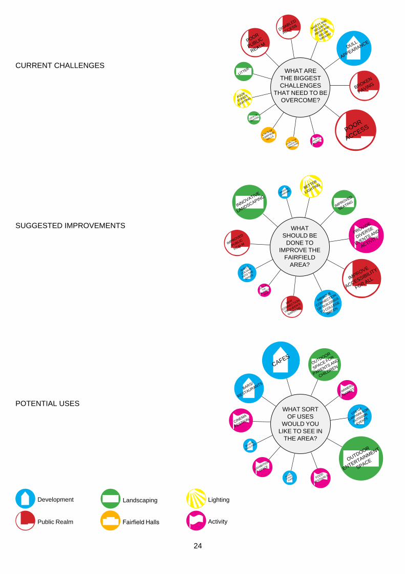
cUrrenT challenG es
Broken
paVinG
liTTer
poor
sTreeT
liGhTinG
lack oF
seaTinG
sTaTe oF
FairField
halls
dUll
appearance
VisiBiliTY oF
FairField
halls naMe
disaBled
access
poor
access
poor
pUBlic
realM
saFeTY and
secUriTY
aBoVe and
BeloW
GroUnd
lack oF
acTiViTY
Wha T are T he B i GG es T challen G es
T ha T need T o B e o V erco M e?
iMproVe
carpark
iMproVe
connecTion
oF BUildinGs
To colleGe
Green
BeTTer
liGhTinG
innoVaTiVe
landscapinG
inJecT
coloUr
inTo The
space
iMproVe
accessiBiliTY
For all
iMproVed
seaTinG
liGhT Up
The
‘FairField’
naMe
proVide
diVerse
eVenTs and
acTiViTYiMproVed
pUBlic
realM
neW
connecTion
To QUeen’s
Gardens
Wha T sho U ld B e
done T o i M pro V e T he
Fair F ield a rea?
sUGGesTed iMproV eMenTs
oUTdoor
space For
parenTs and
children
oUTdoor
enTerTainMenT
space
caFes
sporTs
FaciliTies
inFra-
sTrUc-
TUre/
Bars/
resTaUranTs
Use oF
carpark For
oUTdoor
eVenTs
Food
FesTiVals
FarMers
MarkeT
cineMa
FesTiVal
exhiBiTion
space
Wha T sor T o F U ses
W o U ld Y o U like T o see in
T he area?
poTenTial Uses
development lighting landscaping
activitypublic realm FairfieldHalls
24
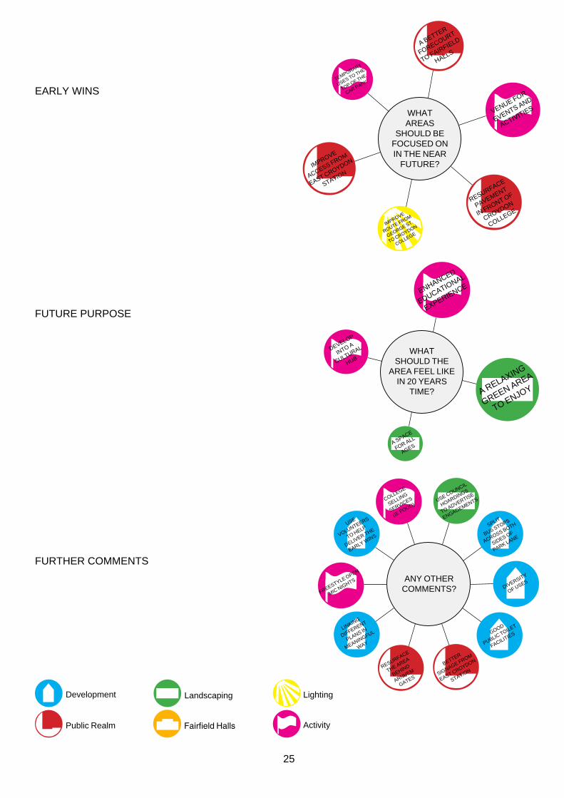
earlY Wins
iMproVe
roUTe FroM
GeorGe sT.
To croYdon
colleGe
VenUe For
eVenTs and
acTiViTies
TeMporarY
Uses To The
Top oF The
car park
iMproVe
access FroM
easT croYdon
sTaTion
resUrFace
paVeMenT
in FronT oF
croYdon
colleGe
a BeTTer
ForecoUrT
To FairField
halls
Wha T areas
sho U ld B e F oc U sed on in T he near
FUTU re?
a relaxinG
Green area
To enJoY
a space
For all
aGes
deVelop
inTo a
cUlTUral
hUB
enhanced
edUcaTional
experience
Wha T sho U ld T he
area F eel like in 20 Y ears
T i M e?
Use coUncil
hoardinGs
To adVerTise
enGaGeMenTs
linkinG
diFFerenT
plans in
MeaninGFUl
WaY
BeTTer
siGnaGe FroM
easT croYdon
sTaTion
spliT
BUs sTops
across BoTh
sides oF
park lane
Good
pUBlic ToileT
FaciliTies
resUrFace
The area
Behind
arnheM
GaTes
diVersiTY
oF Uses
Use
VolUnTeers
To help
deliVer The
earlY Wins
colleGe
sellinG
serVices
(ie Food)
FreesTYle open
Mic niGhTs a n Y oT her c o MM en T s?
FUTUre pUrpose
FU rTher coMM enTs
development lighting landscaping
activitypublic realm FairfieldHalls
25

FUrTher consUlTaTion on The draFT MasTerplan
2.8.7 The draft Fair Field Masterplan was released for public consultation over a six week period between the 3rd september and 15th october 2012. during this period 40 copies of the Masterplan were printed for use at dedicated Masterplan public consultation events, and made available at public libraries. a pdf of the draft Masterplan document was made available on the council website.
2.8.8 Two public consultation eventswereheld,thefirstonthe 6th september in Queens Gardens in conjunction with the Mayors showtime event and the second held behind the arnhem Gates on the 6th october 2012. a total of 37 representations were received, which have been considered indetailtoinformthefinal Masterplan. all representations have been collated and responded to in the Fair Field Masterplan consultation log, available on the council’s website.
2.8.9 The event on 6th september 2012 provided an opportunity for members of the public to review and discuss proposals through an interactive model of the draft Fair Field Masterplan. This material was publicly displayed in a shop on George street between 6th september and 6th october.
2.8.10 The event on 6th october 2012 marked the ongoing engagement process with the various stakeholders, and was used to test the viability of temporary uses to activate college Green. a football tournament between interested parties activated the space. The Masterplan team collaborated with
activation of space during consultion of the masterplan october 2012
carpentry students from croydon college to produce spectator seating, and with Graphics students to produce a publication with ideas for temporary uses for spaces within the Masterplan area. Food was provided by a surrey street Market trader, with music by a local brass band and croydon’s best dJ exports. other attendees included local residents, skateboarders, and local politicians. a workshop was held to discuss the potential for implementing temporary uses in the Masterplan area, which has informedthefinalcontentofthe Masterplan and proposed early Wins.
26 Masterplan engagement october 2012

Football between parties interested in the future of The Fair Field october 2012 27

‘An Emerald necklace’, Third City, Alsop
VANGUARD WAY
From the suburbs to the Sea,
From London to Paris’
2.9 open space conTexT
open space and Green inFrasTrUcTUre West Croydon Station
2.9.1 The croydon Third city Vision set out the objective to connect central croydon with surrounding green spaces through a network of green infrastructure, or ‘emerald
Wandle Park
East Croydon Station
Fair Field
necklace’. This is being taken forwards through the all london
Queen’s Green Grid area Frameworks 7 Gardens & 8, the croydon oapF and the connected croydon programme.
2.9.2 The open space of college Green on Fair Field forms a strong link. This can be strengthened for the future through the masterplan.
2.9.3 The nearby london downlands landscape is connected via the historic ‘Vanguard Way’ route which was the start of a route from london to paris. The proximity of this landscape can be made visible in the urban context of Fair Field.
access To open space
2.9.4 The aspiration must be to meet national guidelines for access to an appropriate mix of green spaces for a range of recreational needs. This is achievable at Fair Field if existing connections are strengthened, especially to park hill, and the site itselfbecomesasignificantgreen space.
Park Hill
Duppas Hill
Fair Field in the context of the ‘emerald necklace’
large Forest Trees to achieve green infrastructure in an urban context
28

2.10 policY conTexT
2.10.1 There are a number of documents which provide policy context for the Fair Field Masterplan or existing reports and documents which have been referred to in preparing the masterplan. These are as follows:
naTional
• national planning policy Framework (2012)
• Technical Guidance to the national planning policy Framework (2012)
• assessing needs and opportunities: a companion Guide to ppG17 (2002)
• planning for Biodiversity and Geological conservation: a Guide to Good practice (2006)
• english heritage and caBe - Guidance on tall buildings (2007)
• deTr – By design: Urban design in the planning system: Towards Better practice
• The Urban design compendium & Urban design compendium 2
• Manual for streets, department for Transport (2007)
• english heritage: streets for all • community infrastructure
regulations 2010, 2011 & 2012
reGional
• The london plan (2011) • all london Green Grid spG
(2012) • accessible london: achieving
an inclusive environment spG (2011)
• shaping neighbourhoods: children and Young people’s play and informal recreation spG (2012)
• Mayor’s economic development strategy (2010)
• cultural Metropolis strategy (2010)
• london’s downlands area Framework (2012)
• Mayor’s Transport strategy (2010)
• emerging Tfl south london sub-regional Transport strategy
• Transport for london streetscape Guidance (2009)
• streets for all (2005) • Transport for london: Making
london a Walkable city (2004) • Tfl interchange Best practice
Guidelines (2008)
local
• london Borough of croydon Unitary development plan, The croydon plan (2006)
• croydon local plan: strategic policies post-examination (2012)
• london Borough of croydon supplementary planning documents and interim planning Guidance
• economic development strategy refresh 2010 - 2012
exisTinG reporTs and reFerence docUMenTs
• We are croydon this is our vision (2010)
• Third city, alsop, croydon Borough council (2007)
• london Borough of croydon’s community strategy (2010-2015)
• infrastructure delivery plan (2012)
• Understanding and shaping the cultural sector in the london Borough of croydon (2010)
• outdoor space needs assessment (2009)
• outdoor space needs assessment standards paper (2009)
• Borough character appraisal (2011)
• Borough character appraisal residential Typologies (2011)
• croydon housing Typologies (2010)
• cMcaap issues and options report, croydon Borough council (2008)
• Baseline analysis of Urban structure layout and public spaces, space syntax (2007)
• draft croydon Transport strategy, JMp Baseline data analysis (2008)
• Wellesley road competition, stage 1 Brief (2008)
• south london route Utilisation strategy, network rail (2008)
29

Illustrative render of Fair Field Masterplan
30

3.0
The MasTerplan
31

3.1 a delIverable MasTerplan
3.1.1 The Masterplan seeks to redefine the Fair Field area pragmatically with a strong focus on public realm and enhancements to College Green itself. such improvements will aid the connectivity and legibility of the whole Masterplan and be the ‘glue’ for the various scaled developments within the area.
3.1.2 The over arching framework of the Masterplan is formed of a grid of similarly scaled development components, which draw on the relevant planning grids which lie latent in the planning of the area.
3.1.3 The Fair Field Masterplan is primarily about delivery: a) because it has been developed alongside key landowners and stakeholders and has sought to be inclusive whilst always adopting a broader more extensive vision; and b) because it has been collectively imagined to be delivered in phases as a series of components.
3.1.4 The Fair Field Masterplan in its entirety is a combination of all these components, with each element being integral to the long term vision and supportive of each other. however, there is an inherent flexibility with regard to the deliverability of many of the individual components. all the different components of the masterplan unite to eventually provide a stronger public urban framework with key north-south and east-west access as well as an improved set of public urban spaces which complement, rather than obstruct, the myriad of uses contained within the area.
3.1.5 The Fair Field Masterplan has been carefully considered to accommodate imminent change in a way that acts as a stepping stone for more far-reaching transformation later.
3.1.6 The Masterplan is based on an analysis of key pedestrian routes defining potential development plots with enlivened active frontages, whilst maintaining the overall area associated as designated Open land (dOl) as contained within the Croydon City Council Udp.
3.1.7 The Masterplan retains the area of the dOl, although in a different configuration.
3.1.8 a redistributed College Green allows for a smaller scaled development bordering its eastern end with the focus of the Green shifted towards park lane.
3.1.9 The area classified DOL in the masterplan is revised to 6,290m2, approximately 30% of which is in an alternative arrangement from the current configuration.
3.1.10 proposals will be considered against the national planning policy Framework (nppF) as a whole and particularly paragraphs 69, 70 73 - 76, london plan policy 1.1, Unitary development plan policy r08, Croydon local plan sp6.
3.1.11 It is of paramount importance that any residential development in the vicinity of the rear of Fairfield halls must undergo thorough acoustic testing to ensure that residents will not be unduly affected by the operations of the Fairfield Halls service yard, and will therefore not limit the long term viability of Fairfield.
32

a deliverable masterplan based upon key pedestrian routes
Key
Key pedestrian routes
enlivened active frontages
Well defined public realm
33

Illustrative masterplan under development : red line boundary highlights redistributed designated Open land (6,290m2)
34
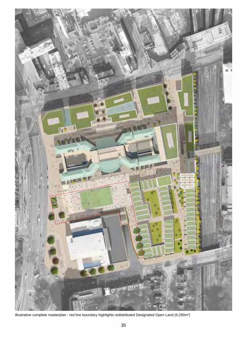
Illustrative complete masterplan : red line boundary highlights redistributed designated Open land (6,290m2)
35

3.2 pUblIC realM paraMeTers
sTreeT level
3.2.1 The public realm parameters provide a framework to transform the pedestrian experience of Fair Field. linking the site coherently with designated public spaces and integrating it with the wider pedestrian movement network are key objectives of the Fair Field Masterplan. pedestrian accessibility, connectivity and legibility are the basis on which the parameters have been established.
3.2.2 The fundamental approach is to establish a simple network of links and squares, connected by a continuous ground plane and step free access to all areas.
3.2.3 Three key routes have been identified to make the overall public realm inclusive to all users and reinforce the grid of pedestrian movement across the site:
• link from east Croydon station to College Green
• link from barclay road to College Green
• link from hazeldean road to College Green
3.2.4 The vertical and horizontal circulation of pedestrians have been considered as equally important to keep both levels as active public realm. The entrance points at street level to the below ground car park and circulation levels have been a focus for upgrade and should provide opportunities for bold features in the public realm.
3.2.5 developments bordering public realm should engage proactively at street level with entrances and active uses where possible to encourage a diverse community of users and uses.
3.2.6 new public realm squares are distinctive places which have their own character as meeting or gathering places. activities from the adjacent institutions can spill out into the urban realm creating a vibrant atmosphere.
3.2.7 varied use of public realm spaces should be made flexible to accommodate a wide variety of users and uses including meanwhile use and spaces for young people.
3.2.8 public realm improvements proposed will contribute to the reduction of anti-social behaviour and by providing an animated, well lit and usable public realm throughout the day and night.
3.2.9 Water may form part of the detailed design of public realm at a later stage; however there are technical challenges in installing a water feature on a concrete deck above a car park.
3.2.10 public realm parameters encourage active frontages which to provide natural/passive surveillance as part of the masterplan.
36

public realm parameter plan - street level
Key
new public realm link Upgraded existing public realm
new public realm square new semi-private link
37
Upgraded public realm access to below ground car park
potential new or improved pedestrian crossing outside of the Masterplan area

belOW GrOUnd
3.2.8 The Fair Field Masterplan area has an underground level which was originally formed as railway cuttings. Most of this is now an underground car park with connections to the subway network.
3.2.9 There are key pedestrian routes in the public realm at Fair Field which happen at the underground level. The use of them should be encouraged through improvements to access, lighting, wayfinding and maintenance. The population of these routes will contribute to safety and security.
3.2.10 The improvements to access that mediate between car park below ground level and the street are important to enhance the character of the subterranean spaces. The greening of the car park level will contribute to the experience of the car park level as public realm. diversifying the appearance of access points with vegetation will contribute to the overall concept for the public realm to use landscape as natural wayfinding. A clear and simple signage strategy will reinforce the key routes.
3.2.11 The approach to materials should respond to the character of pedestrian routes in the public realm at street level for key routes.
3.2.12 The improved access points and Forest Trees planted at car park level will allow increased natural light to the lower level with new openings in the structural slab. during the day the increase in natural light will contribute to improved safety and security.
3.2.13 Significant improvements to lighting of the overall space and key routes are fundamental to sustaining vertical and horizontal circulation.
3.2.14 The existing subways which provide access to the west side of park lane should be upgraded to sustain these important links. subway entrances should be visible and legible at both street level and underground level. The condition of the subways themselves are important parts of the upgraded public realm as key pedestrian links.
3.2.15 links to the key institutions, Croydon College and Fairfield halls from the car park level will increase their connectivity with the wider area with an aim to increase their presence in Croydon Town Centre. buildings should have a positive presence and frontage below ground level, so that different destinations are clearly legible from the car park.
38

public realm parameter plan - below ground level
Key
Upgraded or additional access to above ground level
Upgraded pedestrian routes below ground
private parking pedestrian routes below ground
Upgraded public realm for subways
Forest Trees planted at below ground level for natural wayfinding.
pioneer trees planted at below ground level to distinguish upgraded vertical connections to above ground level.
3939

pUblIC realM paleTTe
3.2.15 high quality materials should be used throughout to inform character and maximise longevity. Material selection must meet the requirements of the public realm design Guide.
3.2.16 The success of the public realm will be dependent on clearly defined and funded maintenance arrangements. This should be in place prior to construction.
3.2.17 Granite kerbs are proposed throughout the masterplan area to provide a consistent, high quality and durable edging that frames the public realm.
3.2.18 Connecting pavements; George street and barclay road area. pavements to existing highways should be improved with the upgrade of materials which complies with the public realm design Guide. natural stone (mid grey granite) to be used where possible with the suggestion of resin bonded gravel to areas which may be more temporary.
3.2.19 squares and shared surfaces should be defined by high quality natural materials such as granite setts. This will tie in with the kerbs and detailing across the whole area. Colour, finish and size of the units will differentiate from adjacent routes and spaces.
3.2.20 The pavement to park lane Frontage should be distinguished with large robust paving such as Granite plank paving to emphasise the space as a strong piece of public realm which prioritises pedestrian traffic.
3.2.21 detailing of edges, steps and ramps are to be robust to withstand the existing and future uses of the public realm such as skating.
3.2.22 street furniture should be integrated in the landscape design where possible. It needs to be robust to withstand skating. Otherwise products should comply with the public realm design Guide.
3.2.23 In situ concrete paving should be laid in areas which are unlikely to be needed to be dug-up in the future.
3.2.24 The pedestrian infrastructure of Fair Field is a mixture of constructed walkways which will mediate levels, creating an accessible and connected urban realm. In situ concrete paving will provide a robust unifying surface. Varying the scale and finish of the concrete will provide simple differentiations in character and scale of spaces. The material is robust and low maintenance. Its aesthetic references the heritage of Croydon’s development.
3.2.25 Throughout the development of the masterplan there will be the need for new boundary treatments to the public realm both temporary and semi permanent while changes are taking place. robust well designed hoardings should be used which provide opportunities for local artists, photographers and designers contribute to them. solid hoardings with imagery should be used to enhance public realm. hoardings to vacant sites could be permeable in their design to allow the visibility of natural vegetation to be an asset to public realm.
40

public realm parameter plan - Material palette
Key
Frontage to park lane/Wellesley road
public squares/shared surfaces
detailing In situ concrete pavements and raised walkways Connecting pavements
extent of Kerbs
41

lIGhTInG saFeTy and seCUrITy
3.2.26 The basic palette of lighting in the public realm should be consistent with the rest of Croydon Town Centre and comply with the public realm design Guide, delivered through Croydon’s street lighting pFI contract. Specific areas should be enhanced with feature lighting to support night time uses where appropriate.
3.2.27 safety and security is the starting point for the Fair Field lighting strategy. a distinguished palette of lighting is proposed to promote envisaged activities and uses, and help develop the night time economy. This is seen as an addition to the existing lighting of the new ‘rotunda’ to Croydon College and uplit frontage of Fairfield Halls. An increased public presence will result in the improved safety and security.
3.2.28 lighting should inform the use of College Green for night time events. This needs to be flexible for a variety of uses. The film projection from Croydon College to the blank wall of the ashcroft Theatre of Fairfield Halls has the potential for further development. This vibrant cultural project links the key institutions at Fair Field, provides innovative creative opportunities and atmospheric lighting. Clearance of the northern facade of the ashcroft Theatre would establish the ongoing use for film projection.
3.2.29 lighting should be low maintenance and energy efficient. The lighting strategy works simultaneously with the natural landscape wayfinding. Lighting from standard columns may be supplemented by uplighting forest trees.
3.2.30 The upgraded public realm of ‘College square’ links George street and College road to Croydon College entrance.
distinctive feature lighting such as Catenary lighting should to characterise this public realm and highlight the presence of Croydon College on George street.
Catenary lighting
3.2.31 College Green is lit at night by the new extension to Croydon College. Improvements to column lighting are informed by the public realm design guide and will dramatically improve the safety and security of the route at night. The aspiration for College Green is that it strengthened as part of the pedestrian route to east Croydon station.
Column lighting complies with public realm design Guide
building lighting to Croydon College
3.2.32 proposed residential development which forms part of the long term masterplan for Fair Field provides potential for a new character of public realm to Fair Field. lighting proposals in this area suggest the character of semi private space. a continuous route is lit with seating objects.
Furniture lighting
3.2.33 building frontage lighting and lit signage to Fairfield Halls can be integrated with facade improvements. This frontage should have a positive contribution to the public realm through lighting.
Lighting Fairfield Halls
Uplighting to trees
42
public realm parameter plan - lighting safety and security
Key
standard column lighting to building Frontage lighting reinforce the primary pedestrian network Furniture lighting to residential
quarterUplighting to trees supplements column lighting lighting and Film projection
Catenary Feature lighting
43

KINNEAR LANDSCAPE ARCHITECTS 3rd Floor West, 1-3 Coate Street, London E2 9AG tel. 020 7729 7781 / fax. 020 7729 8809 / [email protected]
JOB: 796 Fairfield Masterplan
TITLE: Central Green_Section (1 of 2)
SCALE: 1:200@ A3 DATE: 07.02.11 DRAWING No: 796_SK007 REV: -
Croydon College
College GreenLB Un
derp
ass
Subway
TCBs
58.5m
SECTION 1:200
KEY PLAN 1:1000
SE
CTI
ON
LIN
E
WORK IN PROGRESS
landsCape, WayFIndInG and bIOdIversITy
3.2.34 The overall concept for the public realm is bringing green into the heart of Croydon. Fair Field is an important part of the green infrastructure where natural elements are proposed to provide wayfinding within the urban context. In addition the new Legible London wayfinding system highlights routes.
3.2.35 Forest Trees are recognised as the most significant element of urban green infrastructure. They provide natural landscape wayfinding and an opportunity to increase greening and biodiversity in the Masterplan area. The introduction of Forest Trees supports the over arching aim from the Gla to increase canopy cover.
3.2.36 Forest Trees planted at both the car park level and street level are a strong visual landmark, something distinctive to Fair Field. Initial structural analysis of this proposal has been positive, further engineering input will be required
Forest Trees planted at below ground level
to develop the idea and give a more accurate understanding of cost. Ciria have published a comprehensive guide to planting large species trees in urban landscapes which provides useful information on costing, design and management. Maintenance is key to the success of Forest Trees in urban contexts.
3.2.37 pioneer species such as birch and alder planted at the car park level provide green to buildings and the public realm which highlight vertical circulation which is such a key aspect of the public realm connectivity.
3.2.38 semi private spaces can extend from buildings which are currently separated from the public realm by voids to the below ground car park. The greening from below ground can give soft landscape character to these spaces and provide potential for growing projects from the College and future residential development.
Greening to semi-private bridges
3.2.39 vertical greening should be used to enhance pedestrian routes and along the railway line which forms the eastern boundary to Fair Field.
3.2.40 Green and brown roofs have potential to become amenity green space. This should be done where possible to provide visually attractive roofscapes from the high number of taller surrounding buildings.
3.2.41 The protection of existing biodiversity should be considered in the design of the public realm in accordance with nppF which states that there should be net gains in biodiversity where possible.
3.2.42 Green infrastructure in the Masterplan strengthens sustainable water management on the site and flood mitigation through increased tree cover. sUds should be incorporated wherever possible and is another advantage to planting at the basement level.
Growing potential to semi-private bridges
Groups of pioneer species planted at below ground level to highlight vertical circulation
44

Public realm parameter plan - Landscape wayfinding and biodiversity
2.3.2 large Forest trees achieve a significant green infrastructure in dense urban contexts. They increase canopy cover which small trees don’t. research by Ciria has confirmed that Large Forest Trees are the single most important element to providing green infrastructure in urban contexts. They convey great financial social and environmental benefits and make a fundamental contribution to the well being of the population.
Key
pioneer species such as birch and alder planted in groups
Forest Trees
Green Open space
vertical Green
45

3.3 develOpMenT paraMeTers
sTreeT level
3.3.1 as a public-realm and movement-led masterplan, the scope of the Fair Field Masterplan is focused on the basement, ground and first floors of development. As such the development parameters concentrate primarily on setting appropriate footprints, relationships between buildings and ground floor uses, as well as access and servicing arrangements.
3.3.2 although some of the development plots have consented schemes outlining heights and massing parameters, the Masterplan shows illustrative massing for future development, however it does not impose specific height limits.
3.3.3 The anticipated massing of any future development should be sympathetic to the Masterplan in its entirety. Significant height is to be accommodated, although only in a way which activates and delineates the main pedestrian routes. The massing of development blocks should always be undertaken to best compliment the neighbouring public open space both in terms of definition and activity, as well as day lighting and security. The exact heights and massing of developments will be subject to more detailed testing, analysis and evaluation as part of the planning process for individual schemes that come forwards.
3.3.4 There is a fundamental need to respect the setting of surrounding heritage assets including the Chatsworth road Conservation area and listed segas house.
3.3.5 It is acknowledged that whilst the Masterplan represents an ideal fulfilment of a long term vision, the final realisation will be shaped by the significant role of market forces which will play on the influence, timing and levels of development within the Fair Field area moving forward. To this end, the Masterplan has been developed with key phasing objectives in mind.
3.3.6 The clear expectation is of high quality design and appropriate and lasting material selection for all development within the Fair Field Masterplan area.
3.3.7 The benefits of introducing significant residential uses to the area should not be underestimated in achieving the core aspirations for the site.
3.3.8 any residential development should acknowledge the key role of affordable and mixed housing within the site as contained, within the Croydon local plan.
3.3.9 There are also numerous opportunities to accommodate related amenities and community facilities (e.g., play areas, health centres, gyms, creche and nursery facilities, in order to enrich the whole.
3.3.10 Significant importance is also placed on the need for innovative cultural and educational uses and the distinct opportunity to build in these to provide an incubator for local enterprise in accordance with the Croydon local plan enterprise Centre policy.
3.3.11 The aim is to strengthen the role of creative and cultural industries in the area, building on the success of the existing high profile residents in establishing the Fair Field area as a cultural destination.
3.3.12 The development of the Fair Field Masterplan shall be complementary to the character and future development of neighbouring buildings, plots and masterplans.
3.3.13 There is an understandable need for active frontages and prominent building entrances throughout the Fair Field Masterplan area, in order to enliven key pedestrian routes and present an attractive and safe aspect to the Masterplan area.
3.3.14 There is also much importance placed on smaller scale active uses within the Fair Field Masterplan area, to provide a rich mix and hierarchy of activity, enlivening new routes and delineating new movement corridors.
3.3.15 The promotion of community and well being along clear sustainable parameters is of paramount strategic importance with the bringing forth of each new development opportunity. each new building, / public realm improvement, should enrich and enforce the whole.
3.3.16 The development parameters should be very much seen as the starting point of detailed design development through the bringing forth of individual schemes.
46

3.3.17 Croydon Council is exploring the scope of a district energy scheme that would provide low carbon low-cost heat and power to new developments in Croydon Metropolitan Centre. The scheme would be run by an energy services Company and based on gas-fired combined heat and power plant at locations to be confirmed. Should the scheme be implemented, Croydon will expect all commercial and residential developments to be technically compliant to connect to a district energy scheme. Further to this Croydon will expect developments to adhere to its district energy policy contained within the Croydon local plan.
3.3.18 Croydon local plan sp6.2 requires high density residential developments of 20 or more units to incorporate site wide communal heating systems and major development to be enabled for district energy connection.
3.3.19 all new buildings will be encouraged to optimise the use of green and brown roofs to mitigate the impacts of climate change, improve views from high blocks and encourage biodiversity. developments must include sustainable Urban drainage Systems to mitigate flood risk.
3.3.20 Croydon local plan sp6.4 requires developers to work in partnership with the Council, environment agency, community groups, water and highways infrastructure providers and other lead local Flood authorities to reduce flood risk, protect groundwater and aquifers, and minimise the impact of flooding in the borough.
3.3.21 Croydon local plan sp6.5 requires the Council and its partners to promote the implementation of ‘Urban blue Corridors’, enabling a network of multifunctional spaces and corridors that provide safe routes and storage for flood water within the urban environment.
3.3.22 The importance of trees in water management strategies is particularly noteworthy.
3.3.23 all new development will need to consider the net increase in water and waste water demand to serve the area and also any impact the development may have off site further down the network. developers will be required to produce water and drainage strategies to identify any necessary upgrades and ensure compliances with policies 5.14 and 5.15 of the london plan.
3.3.24 The Masterplan actively promotes and upholds the requirement for sustainable development. all development should be brought forth with reference to, and in coherence with, the following policies on sustainable development contained within the Croydon local plan.
3.3.25 Croydon local plan sp6.1 sets out a presumption in favour of sustainable development which is in line with the national planning policy Framework.
3.3.26 Croydon local plan sp6.2 seeks to ensure that future development makes the fullest contribution to minimising carbon dioxide emissions in accordance with the london plan.
3.3.27 Croydon local plan sp6.3 seeks high standards of sustainable design and construction from new development, conversion and refurbishment.
3.3.28 It is important to note that the replacement Udp and Croydon local plan policies require the re-provision or retention of community uses for specific sites within the Fair Field Masterplan, as set out within the components chapter.
3.3.29 On a number of sites covered by the Masterplan, retail activity is envisaged on the ground floor. However, the scale and type of retail activity will need to reflect the extent of the Primary Shopping Area (PSA) as defined in Croydon’s replacement Unitary development plan. This Masterplan is also mindful of the requirement not to undermine proposals to increase and improve the quality of the retail capacity in the retail core as proposed in the OapF.
47

belOW GrOUnd
3.3.23 as a public-realm and movement-led masterplan, the scope of the Fair Field Masterplan is focused on the basement, ground and first floors of development. As such the development parameters concentrate primarily on setting appropriate footprints, relationships between buildings and ground floor uses, as well as access and servicing arrangements.
3.3.24 The development of the carpark will play a pivotal role in improving the use, legibility and perceived safety of new activity and greater movement throughout the area.
3.3.25 practical considerations with regard to future carpark numbers, servicing and infrastructure issues in the development of the podium across its different levels, will need to be carefully considered to make sure that local and neighbourhood needs are maintained and improved upon.
3.3.26 The development parameters should be very much seen as the starting point of detailed design development through the bringing forth of individual schemes.
3.3.27 The adequate provision of accessible toilet facilities is important to encourage visitors to the area. developers are encouraged to include publicly accessible toilets in future ground floor uses to complement those already provided in Fairfield Halls.
3.3.28 developments such as electricity sub-stations, telecoms installations and water pumping stations should be located appropriately to achieve satisfactory flood protection.
48

Key
active frontage
non-active frontage
servicing
Key building entrances
vehicular entrance development parameter plan - street level
Key
active frontage
non-active frontage
servicing
Key building entrances
vehicular entrance development parameter plan - below ground
49
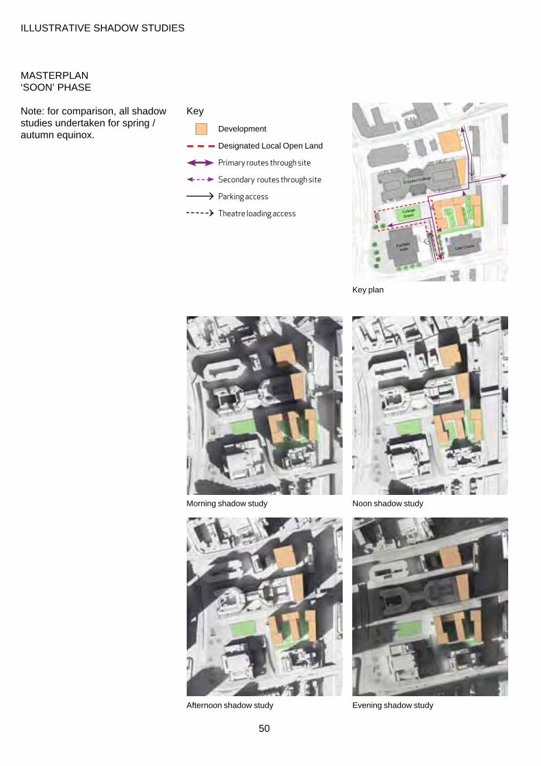
IllUsTraTIve shadOW sTUdIes
MasTerplan ‘sOOn’ phase
note: for comparison, all shadow Key studies undertaken for spring / autumn equinox.
development
designated local Open land
Primary routes through site
Secondary routes through site
Parking access
Theatre loading access
Key plan
College
Green
Fairfield
halls law Courts
Croydon College
noon shadow study Morning shadow study
afternoon shadow study
50
evening shadow study

MasTerplan ‘laTer’ phase
note: for comparison, all shadow Key studies undertaken for spring / autumn equinox. development
designated local Open land
Primary routes through site
Secondary routes through site
Parking access
Theatre loading access
Key plan
College
Green
Fairfield
halls
Croydon College
noon shadow study Morning shadow study
afternoon shadow study
51
evening shadow study
3.4 MOveMenT paraMeTers
sTreeT level
3.4.1 addressing transport and its layout across the Fair Field Masterplan is vital in the creation of a permeable site that encourages sustainable travel and ease of movement throughout this area of Croydon.
3.4.2 Currently, due to the configuration of the site buildings, movement through the site is fragmented with Fairfield Halls, the nCp car park and Croydon Magistrates Court acting as barriers to cross-movements. This section will look at the movement network by mode with key routes summarised in the parameter plans overleaf. It is noted that the general movement strategy is common to both Masterplan options.
pedesTrIan MOveMenT
3.4.3 One of the key objectives of the Masterplan is for the site to be fully permeable with new north - south links connecting George street with barclay road and a dissecting east-west link connecting park lane with altyre road. Internally the site will have numerous footways and links that allow free pedestrian flow providing a simple grid of pedestrian movement.
3.4.4 The east-west link has already been strengthened by the recent at-grade pedestrian crossing across park lane at the south-west corner of the site. The wider Connected Croydon programme will provide a further two at-grade crossings further north across Wellesley road to connect the eastern and western halves of central Croydon.
3.4.5 In addition, the bridge currently connecting the site with altyre road is currently used as a car park access road. This currently provides one narrow footpath with numerous pieces of street clutter. as part of the Masterplan proposals the bridge could be fully pedestrianised.
3.4.6 proposals set out in the east Croydon Masterplan to improve north-south pedestrian crossings across George street are being taken forwards through the east Croydon Interchange Major scheme, due for delivery by 2015.
3.4.7 The provision of new and improved pedestrian crossings on George street will open up new pedestrian routes between east Croydon station and Queens Gardens, the Civic hub and the Mid-Croydon area, a key objective of this Masterplan.
CyCle MOveMenT
3.4.8 Cycling around the site has recently been improved as part of the Connect 2 project linking park hill to the east with Queen’s Gardens and Wandle park to the west, through improvements to barclay road and a new ‘Toucan’ crossing at park lane. Cycle parking will be increased with a proposed cycle hub at billinton hill through the east Croydon Interchange Major scheme.
3.4.9 The pedestrian links that are proposed throughout the site will also be suitable for cyclists. The recommended widths for these shared paths will be 3m a cyclist design speed of 10mph should be achieved on paths shared with pedestrians. In areas of restricted visibility, environmentally sensitive speed reduction measures for
cyclists should be provided, e.g. ‘false bends’, surface treatments, markings and signs. These routes are intended for access to the development and the cycle parking which will be provided throughout the site in line with current policy for the proposed land uses. In addition, a minimum of 10 cycle stands should be provided in close proximity to the College within the public realm. Changes in level should allow for cyclists through channels on stairs or adequately proportioned lifts.
bUs MOveMenT
3.4.10 bus routes are currently provided along park lane, park street, George street and barclay road. These routes will all be retained as part of the Masterplan.
3.4.11 The bus stands located to the western boundary of the Masterplan area currently act as an obstacle to visual connectivity between the Fair Field and Mid Croydon areas. any proposals to relocate these bus stands elsewhere would need to be coordinated at a wider strategic level with the Mid Croydon and OapF transport proposals, and in the context of potential requirements for an increase in bus stand capacity.
TraM MOveMenT
3.4.12 The tram route currently runs southbound down Wellesley road and turns eastbound down George street. On the return journey the tram travels westbound down George street and across park lane continuing along George street. no changes are proposed as part of the Masterplan.
3.4.13 Tram service upgrades are
52

planned by Tfl in 2012/2013 to increase frequency and capacity. These changes will need to be considered as part of any proposals on George street.
vehICUlar MOveMenT
3.4.14 The underground car park will be accessed off barclay road to the south of the site, with the altyre road vehicular connection pedestrianised.
3.4.15 The ramp width has been amended to reflect the reduction in car parking spaces, however still accommodating service vehicle movements. Initial modeling has demonstrated the reduced ramp can accommodate the anticipated level of vehicle movements and further assessment should accompany any detailed scheme or planning application.
3.4.16 The proposed servicing arrangements for the Masterplan area are illustrated in the movement parameter plan and described in outline below. The detail of these routes and servicing areas will be provided by any subsequent planning applications with regard to vehicle manoeuvres, noise and visual effects.
3.4.17 FF19 – Fairfield Halls. Servicing for the Fairfield Hall is required by a range of vehicle sizes up to and including articulated lorries. service access will be taken, as at present, from the ramp from barclay road. It is understood that the Fairfield hall and the ashcroft Theatre currently use part of the existing road to undertake the necessary turning movements. however, it is also currently planned that the Fairfield Hall will install a lorry lift to allow direct movement of goods
from the lorries to the stage. Wsp have undertaken the necessary swept path analysis requested by the Fairfield Hall in determining the design and dimensions of the car park ramp, and the necessary space would be maintained to accommodate their movements both in the interim stage before the lorry lift is installed and after this time when the road is narrowed.
3.4.18 FF23/22 – barclay road development. Infrequent servicing for the barclay road residential development is proposed from the existing ramped access from College road (FF11 station link) at the north-east corner of the site. It is proposed that part of the deck at the south-east of the College buildings would be raised to provide better connection with the pedestrian rail bridge, whilst also allowing service vehicle access under the new residential buildings. a clear height of 5m should be provided within this area.
3.4.19 FF7/FF8 - College road should be retained either in whole or part, as a vehicular access to the site and will also provide access for vehicles servicing plots FF1, FF2, FF3, FF7 and FF8 (as present).
3.4.20 emergency vehicle access should be available on all vehicle access routes described above as well as within the College Green area and through the new residential development as demonstrated on the parameter plans below.
3.4.21 Taxi drop-off and pick-up provision is provided on the Fairfield Halls forecourt. Detailed proposals for taxi provision will
be addressed through individual planning applications.
3.4.22 Coach set-down and pick-up is required for the Fairfield Halls. This will be provided in the Fairfield Halls forecourt and should be accommodated within the detailed design of this area.
53

Pedestrian Movement
Cyclist Movement
Bus Movement
Tram Movement
Vehicular Movement
Servicing Movement
Servicing Movement (underground)
Emergency Access only
Proposed Crossing
Potential Crossing
Coach and Taxi
Movement parameter plan - street level
servicing movement Key
servicing movement (underground)pedestrian movement
emergency vehicle access only Cyclist movement
Coach and Taxi bus movement
proposed crossing Tram movement
potential crossing vehicular movement
54
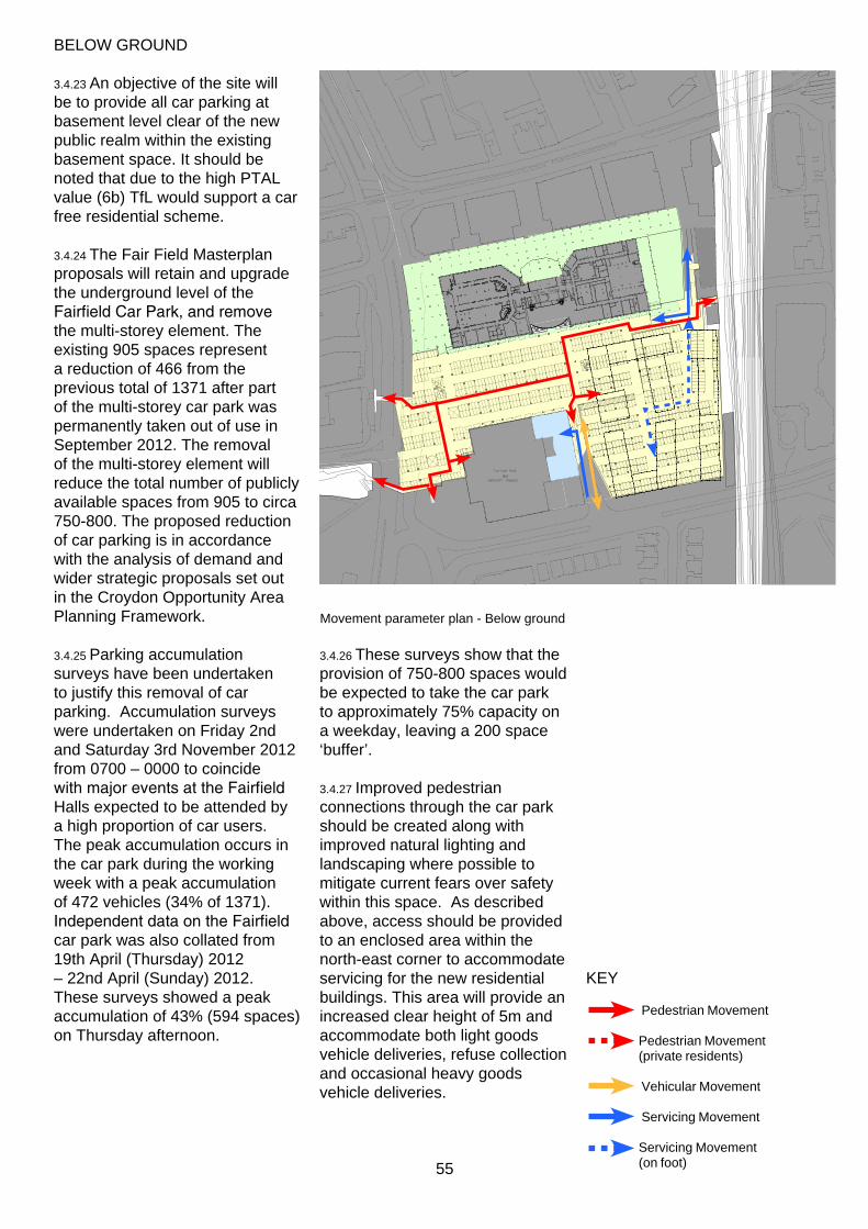
belOW GrOUnd
3.4.23 an objective of the site will be to provide all car parking at basement level clear of the new public realm within the existing basement space. It should be noted that due to the high pTal value (6b) Tfl would support a car free residential scheme.
3.4.24 The Fair Field Masterplan proposals will retain and upgrade the underground level of the Fairfield Car Park, and remove the multi-storey element. The existing 905 spaces represent a reduction of 466 from the previous total of 1371 after part of the multi-storey car park was permanently taken out of use in september 2012. The removal of the multi-storey element will reduce the total number of publicly available spaces from 905 to circa 750-800. The proposed reduction of car parking is in accordance with the analysis of demand and wider strategic proposals set out in the Croydon Opportunity area planning Framework.
3.4.25 parking accumulation surveys have been undertaken to justify this removal of car parking. accumulation surveys were undertaken on Friday 2nd and saturday 3rd november 2012 from 0700 – 0000 to coincide with major events at the Fairfield halls expected to be attended by a high proportion of car users. The peak accumulation occurs in the car park during the working week with a peak accumulation of 472 vehicles (34% of 1371). Independent data on the Fairfield car park was also collated from 19th april (Thursday) 2012 – 22nd april (sunday) 2012. These surveys showed a peak accumulation of 43% (594 spaces) on Thursday afternoon.
Movement parameter plan - below ground
3.4.26 These surveys show that the provision of 750-800 spaces would be expected to take the car park to approximately 75% capacity on a weekday, leaving a 200 space ‘buffer’.
3.4.27 Improved pedestrian connections through the car park should be created along with improved natural lighting and landscaping where possible to mitigate current fears over safety within this space. as described above, access should be provided to an enclosed area within the north-east corner to accommodate servicing for the new residential Key buildings. This area will provide an
pedestrian Movement increased clear height of 5m and accommodate both light goods pedestrian Movement vehicle deliveries, refuse collection (private residents) and occasional heavy goods
vehicular Movement vehicle deliveries. servicing Movement
servicing Movement (on foot) 55
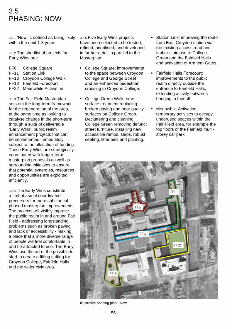
3.5 phasInG: nOW
3.5.1 ‘Now’ is defined as being likely within the next 1-3 years.
3.5.2 The shortlist of projects for early Wins are:
FF6 College square FF11 station link FF13 Croydon College Walk FF18 Fairfield Forecourt FF22 Meanwhile activation
3.5.3 The Fair Field Masterplan sets out the long-term framework for the regeneration of the area, at the same time as looking to catalyse change in the short-term through a suite of deliverable ‘early Wins’; public realm enhancement projects that can be implemented immediately subject to the allocation of funding. These early Wins are strategically coordinated with longer-term masterplan proposals as well as surrounding initiatives to ensure that potential synergies, resources and opportunities are exploited efficiently.
3.5.4 The early Wins constitute a first phase of coordinated precursors for more substantial phased masterplan improvements. The projects will visibly improve the public realm in and around Fair Field - addressing longstanding problems such as broken paving and lack of accessibility - making a place that a more diverse range of people will feel comfortable in and be attracted to use. The early Wins use the art of the possible to start to create a fitting setting for Croydon College, Fairfield Halls and the wider civic area.
3.5.5 Five early Wins projects have been selected to be tested, refined, prioritised, and developed in further detail in parallel to the Masterplan:
• College square; improvements to the space between Croydon College and George street and an enhanced pedestrian crossing to Croydon College.
• College Green Walk, new surface treatment replacing broken paving and poor quality surfaces on College Green. decluttering and cleaning College Green removing defunct street furniture. Installing new accessible ramps, steps, robust seating, litter bins and planting.
• station link; improving the route from east Croydon station via the existing access road and timber staircase to College Green and the Fairfield Halls and activation of arnhem Gates.
• Fairfield Halls Forecourt; improvements to the public realm directly outside the entrance to Fairfield Halls, extending activity outwards bringing in footfall.
• Meanwhile activation; temporary activities to occupy underused spaces within the Fair Field area, for example the top floors of the Fairfield multi-storey car park.
Illustrative phasing plan - now
FF6
FF11
FF22
FF18
FF13
56

3.6 phasInG: sOOn
3.6.1 ‘Soon’ is defined as being likely within the next 3-6 years.
3.6.2 The components that are within this phase are:
FF3 essex house site FF8 east College site FF9 substation FF11 station link FF12 Croydon College perimeter FF14 park lane square FF15 College Green West FF16 College Green east
(contained within FF22) FF17 park lane Walk FF19 Fairfield Halls FF20 service yard FF21 Fairfield Walk FF22 barclay rd. development n. FF24 Carpark ramp FF25 barclay road Walk
FF21
FF24
FF25
FF22
FF20
FF14 FF15
FF19
FF17
FF12
FF12
FF12
FF9
FF3
FF8
FF11
Illustrative phasing plan - soon
57
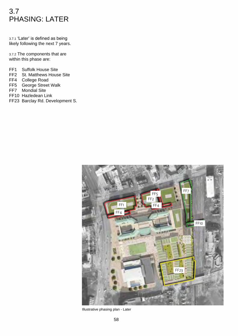
3.7 phasInG: laTer
3.7.1 ‘Later’ is defined as being likely following the next 7 years.
3.7.2 The components that are within this phase are:
FF1 suffolk house site FF2 st. Matthews house site FF4 College road FF5 George street Walk FF7 Mondial site FF10 hazledean link FF23 barclay rd. development s.
FF23
FF1
FF2
FF7
FF4
FF4
FF5
FF10
Illustrative phasing plan - later
58

3.8 CharaCTer areas
3.8.1 The character areas are:
• George street • station link • College • College Green • park lane • Fairfield Halls • barclay road development
3.8.2 The Fair Field masterplan has seven character areas defining a variety of open spaces, public realm and key institutions. These character areas are defined by the proposed buildings which surround them. They have a variety of uses, typologies and characters which will support and enhance the envisaged open spaces. The buildings are used to create open spaces ranging from public to private in order to provide opportunities for different kinds of outdoor activities.
George Street Character Area Station Link
Character Area
College Character Area
College Green Character Area
Park Lane Character Area
Fairfield Halls Character Area
Barclay Road Development Character Area
Illustrative plan highlighting Character areas
59

3.9 CharaCTer desCrIpTIOns
GeOrGe sTreeT
3.9.1 The future of George street is a vibrant urban connection between George street and College road. active frontages to buildings bring life to public realm with the potential for future change and development.
3.9.2 The presence of Croydon College is key to the success of the future aspiration. young energetic and creative activity is encouraged in the urban realm.
3.9.3 When passing through or spending time in the George street area the vicinity of an important educational institution should be apparent.
3.9.4 educational activities such as cooking, hair and beauty and fine art which are all courses offered at Croydon College should be present at street level. This would provide an active frontage to Croydon College and promote the College’s presence in the city centre.
3.9.5 The ‘College square’ provides an important piece of urban realm which is a forecourt to Croydon College. distinctive public space will set the context for successful use of buildings for commercial/ residential opportunities.
George Street Character Area
60

sTaTIOn lInK
3.9.6 east Croydon station is one 3.9.9 pedestrianisation of the railway of the busiest train stations in bridge brings needed connection london. The relationship between from the east. The southern part of east Croydon station to the Fair this character area becomes a critical Field area is envisaged as a node for pedestrian circulation. strong linking piece of urban realm through phased development 3.9.10 The arnhem gate is to be proposals including a new preserved and celebrated through public square linking the existing public realm improvements. crossing from the station with the development sites to the south.
3.9.7 The route will mediate levels seamlessly with a raised walkway to bring pedestrians up to College Green and proposed development areas in the long term. pedestrian priority will be evident in the arrangement of the walkway and will be highly visible from the road crossing of east Croydon station.
3.9.8 an arcade arrangement from the east College site would allow for a more generous north south circulation adjacent to this plot.
Station Link Character Area
61

COlleGe
3.9.11 The College building is an important part of the future of Fair Field. Opportunities for more student presence in the public realm should be encouraged.
3.9.12 a masterplan strategy which aims to do that links the college building to the surrounding streets and public realm with semi private balconies to allow some of the activities from within the building to spill out into the urban realm such as growing food and sitting out spaces.
3.9.13 The student run ‘Chefs’ restaurant provides an exciting opportunity for this to happen as well as build a relationship with food growing.
3.9.14 Ground floor legibility of activity within the building should bring the surrounding College road and College green to life.
3.9.15 Meanwhile use of the public realm for college projects is encouraged to activate surrounding spaces.
3.9.16 public access through the centre of the college should be maintained to promote mixed use of the area.
College Character Area
62
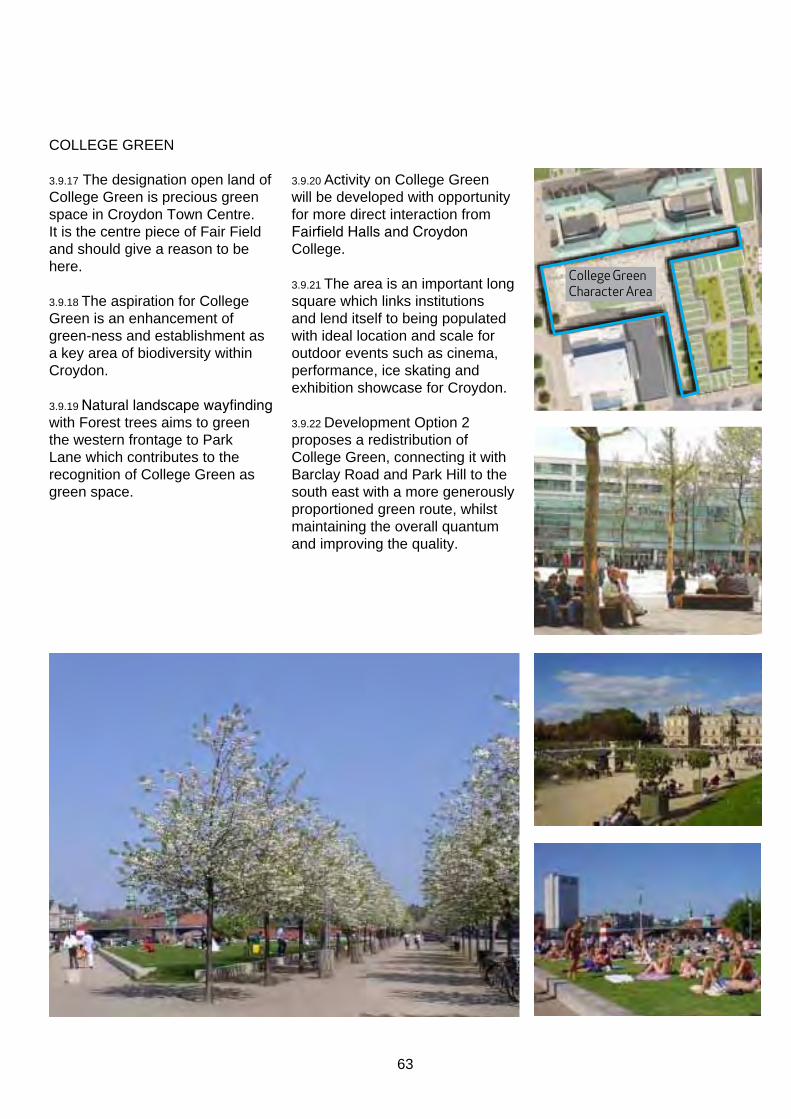
COlleGe Green
3.9.17 The designation open land of College Green is precious green space in Croydon Town Centre. It is the centre piece of Fair Field and should give a reason to be here.
3.9.18 The aspiration for College Green is an enhancement of green-ness and establishment as a key area of biodiversity within Croydon.
3.9.19 Natural landscape wayfinding with Forest trees aims to green the western frontage to park lane which contributes to the recognition of College Green as green space.
3.9.20 activity on College Green will be developed with opportunity for more direct interaction from Fairfield Halls and Croydon College.
3.9.21 The area is an important long square which links institutions and lend itself to being populated with ideal location and scale for outdoor events such as cinema, performance, ice skating and exhibition showcase for Croydon.
3.9.22 development Option 2 proposes a redistribution of College Green, connecting it with barclay road and park hill to the south east with a more generously proportioned green route, whilst maintaining the overall quantum and improving the quality.
College Green Character Area
63

parK lane
3.9.23 The frontage of Fair Field presents an oportunity for the considered placement of Forest trees which suit the grand scale of Fairfield Halls and Croydon College.
3.9.24 distinctive to Fair Field and its relationship with a below ground level, trees emerge from the below ground car park.
3.9.25 The area is characterised by consistent public realm at street level from north to south with a coherent vertical circulation and access.
3.9.26Frontage to Fairfield Halls has a pedestrian priority with integrated parking facilities which allow pedestrian traffic to permeate. The visibility of the institution and access from the wider area by pedestrians is enhanced with a connection to an at-grade crossing to the west.
Park Lane Character Area
64

FaIrFIeld halls
3.9.27 a cultural centre for Fair Field, which informs the area’s potential to have people and activities spilling out to the adjacent spaces makes Fairfield Halls long term presence in the masterplan very important.
3.9.28 The wider influence of the Fairfield Halls on the character of the surrounding area, and indeed for the whole of Croydon, cannot be overstated.
3.9.29 The character of the 4 elevations of Fairfield Halls have a direct relationship to the adjacent uses of the urban realm. There are opportunities to create additional entrances and/or new active frontages to the north side of Fairfield Halls facing College Green.
3.9.30 Improvements to servicing and delivery access the halls are a major opportunity for long term change and development for the adjacent areas.
3.9.31 an external presence of the creativity and cultural activity will define the Fairfield Halls area and increase its legibility to the wider urban context.
3.9.32 refurbishment of the building will be driven by some of these aspirations which celebrate it as an important part of Fair Field.
3.9.33 The use of film projection on blank facades is encouraged to activate public realm along with lighting improvements to the entrance canopy.
Fairfield Halls Character Area
65

barClay rOad develOpMenT
3.9.34 The quality of proposed residential development on the north side of barclay road is characterised by a green infrastructure.
3.9.35 semi private space contributes to improved access and circulation of Fair Field and residential use becomes integrated city centre accommodation.
3.9.36 Green semi private space to south and east boundaries of College Green enhance designated open land for public use.
low level townhouses
Green courtyards surrounded by lower level development
66
3.9.37 routes through the development distinguished in appropriate palette to reflect the residential character within an urban setting.
3.9.38 The vicinity to the Chatswoth Road Conservation Area justifies the location as a residential destination.
Barclay Road Character Area
completed
Barclay Road Character Area in development
protective edge with an open interior onto courtyards

67

Illustrative render of Fair Field masterplan
68

4.0
The ComponenTs
69
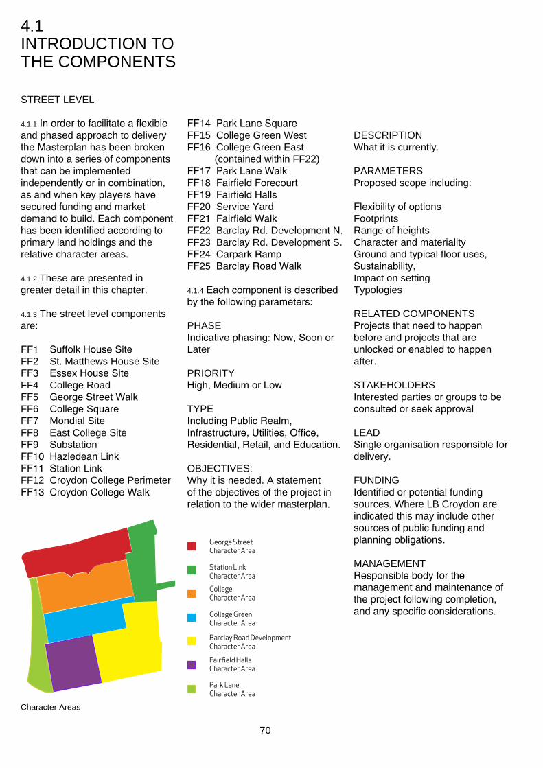
4.1 InTroduCTIon To The ComponenTs
sTreeT LeveL
4.1.1 In order to facilitate a flexible and phased approach to delivery the Masterplan has been broken down into a series of components that can be implemented independently or in combination, as and when key players have secured funding and market demand to build. Each component has been identified according to primary land holdings and the relative character areas.
4.1.2 These are presented in greater detail in this chapter.
4.1.3 The street level components are:
FF1 Suffolk House Site FF2 st. matthews house site FF3 Essex House Site FF4 College road FF5 George Street Walk FF6 College square FF7 mondial site FF8 east College site FF9 Substation FF10 Hazledean Link FF11 Station Link FF12 Croydon College perimeter FF13 Croydon College Walk
Character Areas
FF14 Park Lane Square FF15 College Green West FF16 College Green east
(contained within FF22) FF17 Park Lane Walk FF18 Fairfield Forecourt FF19 Fairfield Halls FF20 service Yard FF21 Fairfield Walk FF22 Barclay rd. development n. FF23 Barclay rd. development s. FF24 Carpark Ramp FF25 Barclay Road Walk
4.1.4 Each component is described by the following parameters:
phAse Indicative phasing: Now, Soon or Later
prIorITY High, Medium or Low
TYpe Including Public Realm, Infrastructure, Utilities, Office, Residential, Retail, and Education.
oBJeCTIves: Why it is needed. A statement of the objectives of the project in relation to the wider masterplan.
George Street Character Area
Station Link Character Area
College Character Area
College Green Character Area
Barclay Road Development Character Area
Park Lane Character Area
Fairfield Halls Character Area
70
desCrIpTIon What it is currently.
pArAmeTers proposed scope including:
Flexibility of options Footprints range of heights Character and materiality Ground and typical floor uses, Sustainability, Impact on setting Typologies
reLATed ComponenTs Projects that need to happen before and projects that are unlocked or enabled to happen after.
sTAKehoLders Interested parties or groups to be consulted or seek approval
LeAd Single organisation responsible for delivery.
FundInG Identified or potential funding sources. Where LB Croydon are indicated this may include other sources of public funding and planning obligations.
mAnAGemenT Responsible body for the management and maintenance of the project following completion, and any specific considerations.
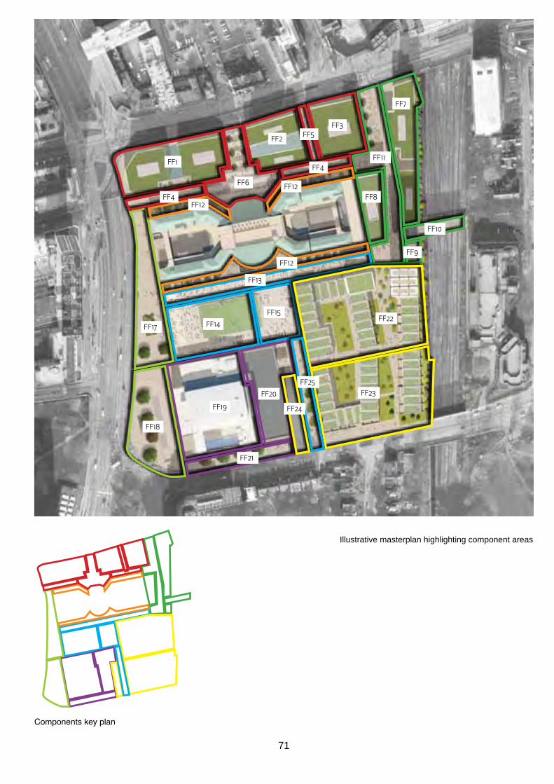
FF1
FF4
FF4
FF6
FF5
FF7
FF8
FF9
FF11
FF10
FF22
FF12
FF12
FF12
FF15
FF14FF17
FF18
FF19
FF20
FF21
FF13
FF23
FF2
FF3
FF25
FF24
Illustrative masterplan highlighting component areas
Components key plan
71
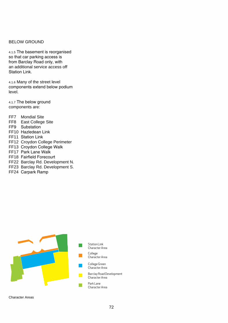
BeLoW Ground
4.1.5 The basement is reorganised so that car parking access is from Barclay Road only, with an additional service access off Station Link.
4.1.6 many of the street level components extend below podium level.
4.1.7 The below ground components are:
FF7 mondial site FF8 east College site FF9 Substation FF10 Hazledean Link FF11 Station Link FF12 Croydon College perimeter FF13 Croydon College Walk FF17 Park Lane Walk FF18 Fairfield Forecourt FF22 Barclay rd. development n. FF23 Barclay rd. development s. FF24 Carpark Ramp
Station Link Character Area
College Character Area
College Green Character Area
Park Lane Character Area
Barclay Road Development Character Area
Character Areas
72

FF7 FF8
FF9FF11
FF22
FF12
FF12
FF17
FF18
FF13
FF23FF24
FF10
FF12
Basement car parking plan highlighting component areas
Components key plan
73

FF1 Suffolk House Site
phAse: Later
prIorITY: medium
TYPE: Retail/Office/Residential
oBJeCTIves: Provide a high quality new building to define the prominent corner of George Street and Park Lane, improve north-south pedestrian permeability, and reinforce active frontages.
desCrIpTIon The building on the site is currently underused through a lack of footfall to the south side of George street.
pArAmeTers The illustrative massing is consistent with the mid-rise city scale, reinforcing the strong urban grid. The height of the development will be subject to detailed testing, analysis and evaluation as part of the planning process for any future proposals.
The ground floor should be predominantly active frontage, especially facing George street and College road.
A mix of upper floor uses is anticipated.
The materiality of any building development should reflect its civic presence. Materials should be of a significant quality and reflect a characteristic of permanence. Any glazed link between the blocks should be lightweight in appearance and subservient to the mass of the adjacent blocks in terms of appearance.
Technical compliance with a potential CmC district energy scheme and adherence to Croydon’s policy on district energy.
A green roof strategy for biodiversity and rainwater attenuation purposes is encouraged.
The quality of the urban realm is to reflect the immediate environment:
• local, intimate square off College road and
• pedestrian priority passage between building plots
Temporary improvements to the development site and meanwhile uses are encouraged to address vacancy in the short-term, where these can act as a catalyst for longer-term regeneration. Where possible, temporary uses should involve local institutions and benefit the surrounding community.
reLATed ComponenTs FF4 College road FF6 College square
LeAd metropolitan properties / Freshwater
FundInG private sector funding
The illustrative massing of the blocks is shown at 19.5m above ground level.
FF1
mAnAGemenT metropolitan properties / Freshwater
Key
retail
Office/Residential
Loading
Possible glazed link
The indicative ground floor uses maximise active frontage to both George Street and College Road, whilst the upper levels allow for a configuration of office or residential accommodation.
Indicative typical upper floor uses
George Street
Park
Lan
e
Indicative ground floor uses
74

Biodiversity green roof Urban realm should be appropriate to the scale of the immediate environment.
Activity to enliven the space throughout maintain retail units at ground level. potential connection through to George the day and improve the feeling of safety street by a semi-private glazed arcade. at night.
Materials should reinforce a strong sense of civic presence and reflect a feeling of quality and permanence. Illustrative materials shown are cast natural stone, brick and anodised aluminium.
75

FF2 st. matthews house site
phAse: Later
prIorITY: medium
TYPE: Retail/Office/Residential
oBJeCTIves: Opportunity for a significant mixed-use development to define the George Street frontage, and gain valuable active frontage.
desCrIpTIon The existing buildings fail to engage with the surrounding streetscape through a lack of ground floor active frontages. A raised north/south walkway provides permeability but the level difference reduces accessibility.
pArAmeTers The illustrative massing is consistent with the mid-rise city scale, reinforcing the strong urban grid. It is recommended that the development steps up in scale towards George street to address its prominent frontage to east Croydon station. The height of the development will be subject to detailed testing, analysis and evaluation as part of the planning process for any future proposals.
Ground floor active frontages should primarily address George Street and College Square, with servicing from College road. A mix of upper floor uses is anticipated.
The materiality of any building development should reflect its civic presence. Materials should be of a significant quality and reflect a characteristic of permanence. Any glazed link between the blocks should be lightweight in appearance and subservient to the mass of the adjacent blocks in terms of appearance.
A green roof strategy for biodiversity and rainwater attenuation purposes is encouraged.
Technical compliance with a potential CmC district energy scheme and adherence to Croydon’s policy on district energy.
high quality elevations to enhance the setting of the locally listed buildings opposite on George street.
The quality of the urban realm is to reflect the immediate environment:
• local, intimate square off College road and
• pedestrian priority passage between building plots
Temporary improvements to the development site and meanwhile uses are encouraged to address vacancy in the short-term, where these can act as a catalyst for longer-term regeneration. Where possible, temporary uses should involve local institutions and benefit the surrounding community.
reLATed ComponenTs FF4 College road FF5 George Street Walk FF6 College square
The illustrative massing shows the George Street block 25.5m above ground level, and the College Road 18m above ground level.
FF2
LeAd metropolitan properties / Freshwater
FundInG private sector funding
mAnAGemenT metropolitan properties / Freshwater
Key
retail
Office/Residential
Loading
Possible glazed link
The indicative ground floor uses maximise active frontage to both George Street and College Road, whilst the upper levels allow for a configuration of office or residential accommodation.
George Street block
College Road block
Indicative typical upper floor uses George Street
Indicative ground floor uses
76

Biodiversity green roof
Activity in the arcade space could be over A new covered shopping arcade would help to maintain active use throughout the day as two levels. well as providing a retail destination.
Materials should reinforce a strong sense of civic presence and reflect a feeling of quality and permanence. Illustrative materials shown are cast natural stone, brick and anodised aluminium.
77

FF3 Essex House Site
phAse: soon
prIorITY: medium
TYPE: Retail/Office/Residential
oBJeCTIves: Provide a prominent landmark / gateway to the masterplan area from east Croydon station and valuable active frontage to George Street and Station Link.
desCrIpTIon The site is currently a vacant plot.
pArAmeTers The site has planning permission for an 18 storey office building comprising a total of 258,000 sq ft. The scheme includes the landscaping of the adjacent area of College road to the east.
The illustrative masterplan shows a block height of 30m above ground level. should an alternative scheme be developed from the extant consent, taller proposals should increase in slenderness in all dimensions to minimise their visual and environmental impact. The height of the development will be subject to detailed testing, analysis and evaluation as part of the planning process for any future proposals.
A mix of uses to encourage active frontage is encouraged at ground level.
The materiality of any building development should reflect its civic presence and prominent location. Materials should be of a significant quality and reflect a characteristic of permanence.
How the building appears at all times of day should be carefully considered in response to its prominent location, possibly via the inclusion of a dynamic lighting
scheme. Where decorative effects are employed, low energy long life sources should be specified.
A green roof strategy for amenity, biodiversity and rainwater attenuation is encouraged.
Technical compliance with a potential CmC district energy scheme and adherence to Croydon’s policy on district energy.
Temporary improvements to the development site and meanwhile uses are encouraged to address vacancy in the short-term, where these can act as a catalyst for longer-term regeneration. Where possible, temporary uses should involve local institutions and benefit the surrounding community.
reLATed ComponenTs FF4 College road FF6 College square FF11 Station Link
LeAd Terrace hill
The current Chroma planning permission allows for the full footprint to extend to 18 storeys. Developments beyond this height should increase in slenderness.
FF3
FundInG private sector funding
mAnAGemenT Terrace hill
Key
retail
Office/Residential
Loading
The indicative ground floor use is to maximise active frontage to both George Street, Station Link and College Road, whilst the upper levels allow for a configuration of office or residential accommodation.
Indicative typical upper floor uses
George Street
Indicative ground floor uses
Station Link
78
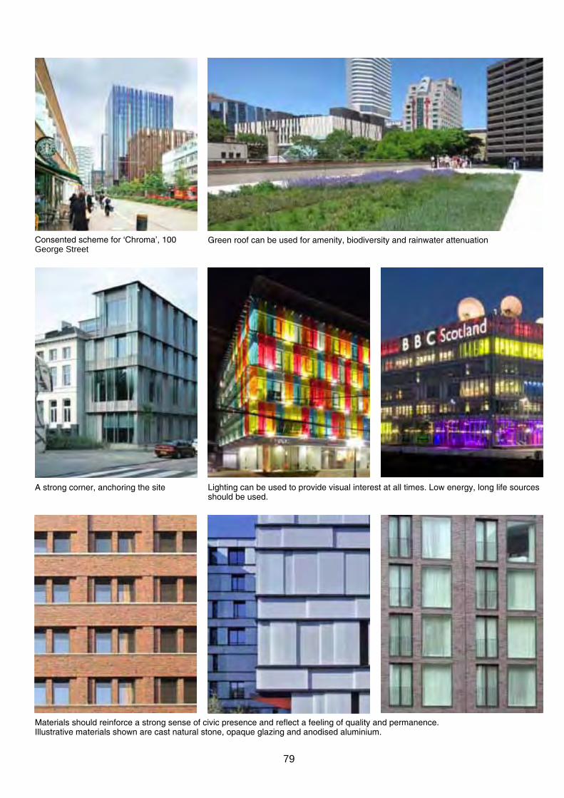
Consented scheme for ‘Chroma’, 100 Green roof can be used for amenity, biodiversity and rainwater attenuation George street
A strong corner, anchoring the site Lighting can be used to provide visual interest at all times. Low energy, long life sources should be used.
Materials should reinforce a strong sense of civic presence and reflect a feeling of quality and permanence. Illustrative materials shown are cast natural stone, opaque glazing and anodised aluminium.
79

FF4 College road
phAse: Later
prIorITY: Low
TYPE: Public Realm
oBJeCTIves: Improve pedestrian environment on College road and setting of Croydon College..
desCrIpTIon College road currently performs well as a service and access road, but lacks the active frontages and quality public realm necessary to provide a positive environment for pedestrians.
pArAmeTers The local urban public realm should be addressed in consideration of the following criteria:
• provides a key secondary commercial link to town centre
• urban realm acts as a predominantly pedestrian transition
• alternative commercial activities and active frontages
• pedestrian priority surfaces • possibly slow traffic with passive traffic calming measures
• allow for appropriate servicing and access
• few parking spaces may be provided, delineated in shared surfaces
• the quality of the urban realm is to reflect the immediate environment with local, intimate squares off College road and pedestrian priority passage ways between building plots.
reLATed ComponenTs FF1 Suffolk House Site FF2 st. matthews house site FF3 Essex House Site FF5 George Street Walk FF6 College square FF11 Station Link FF17 Park Lane Walk
LeAd Croydon Council
FF4
FF4
sTAKehoLders metropolitan properties / Freshwater Terrace hill Croydon College
FundInG Public s106 CIL
mAnAGemenT Croydon Council
College Road to be a shared surface with areas of retail, offices and seating with reduced parking
80

FF5 George Street Walk
phAse: Later
prIorITY: medium
TYPE: Public Realm
oBJeCTIves: Improve permeability between George street and College road.
desCrIpTIon The existing north/south pedestrian link in this area is raised and therefore reduces accessibility.
pArAmeTers The local urban public realm should be addressed in consideration of the following criteria:
• provides a key secondary commercial link to town centre
• pedestrian priority surfaces • allow for appropriate servicing
and access • the quality of the urban realm is to reflect the immediate
environment with local, intimate passage ways between building plots.
• Lighting must be designed to provide a safe and even lit experience. Careful attention must be made to light under the canopy of trees to avoid ‘dark spots’.
• The link should be lined with active frontages to provide passive surveillance.
• recommended minimum width of 8 metres.
reLATed ComponenTs FF2 st. matthews house site FF3 Essex House Site FF4 College road
LeAd metropolitan properties / Freshwater
sTAKehoLders metropolitan properties / Freshwater Terrace hill Croydon College
FF5
FundInG private sector funding s106
mAnAGemenT metropolitan properties / Freshwater
The street is a secondary route which remains light and safe at night
81
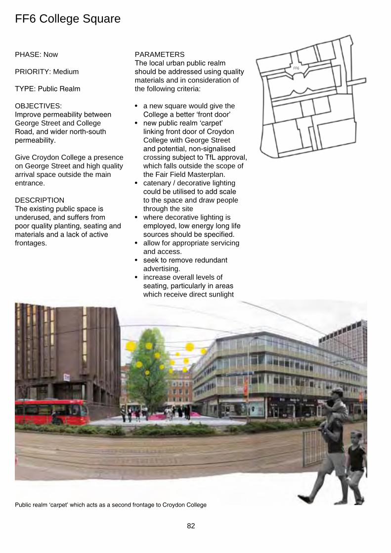
FF6
FF6 College square
phAse: now
prIorITY: medium
TYPE: Public Realm
oBJeCTIves: Improve permeability between George street and College Road, and wider north-south permeability.
Give Croydon College a presence on George street and high quality arrival space outside the main entrance.
desCrIpTIon The existing public space is underused, and suffers from poor quality planting, seating and materials and a lack of active frontages.
pArAmeTers The local urban public realm should be addressed using quality materials and in consideration of the following criteria:
• a new square would give the College a better ‘front door’
• new public realm ‘carpet’ linking front door of Croydon College with George street and potential, non-signalised crossing subject to TfL approval, which falls outside the scope of the Fair Field masterplan.
• catenary / decorative lighting could be utilised to add scale to the space and draw people through the site
• where decorative lighting is employed, low energy long life sources should be specified.
• allow for appropriate servicing and access.
• seek to remove redundant advertising.
• increase overall levels of seating, particularly in areas which receive direct sunlight
Public realm ‘carpet’ which acts as a second frontage to Croydon College
82
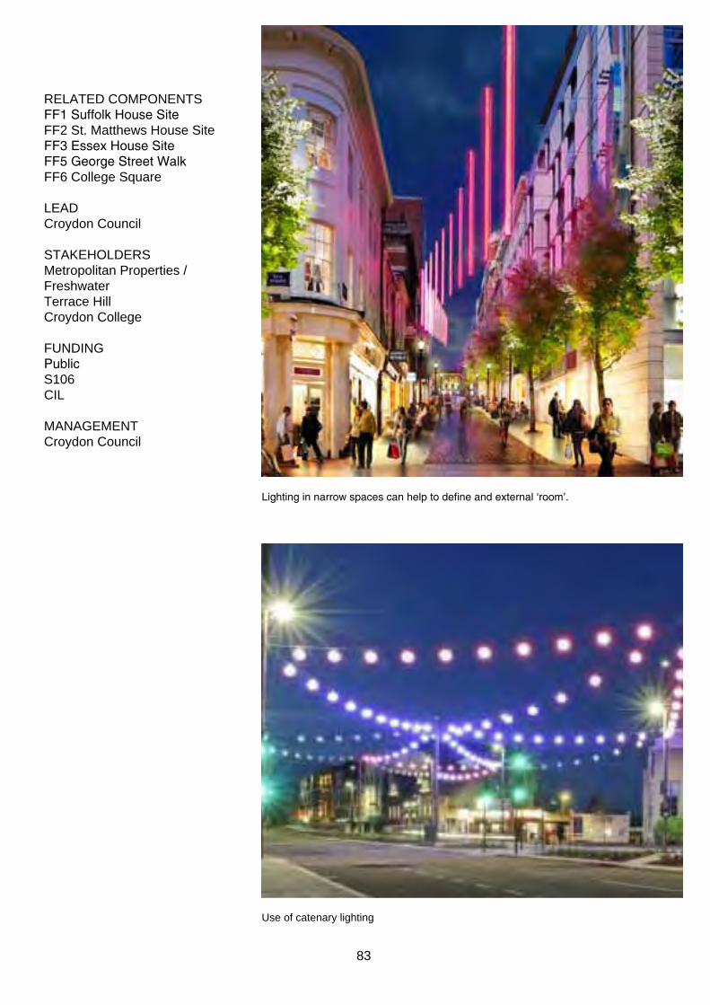
reLATed ComponenTs FF1 Suffolk House Site FF2 st. matthews house site FF3 Essex House Site FF5 George Street Walk FF6 College square
LeAd Croydon Council
sTAKehoLders metropolitan properties / Freshwater Terrace hill Croydon College
FundInG Public s106 CIL
mAnAGemenT Croydon Council
Lighting in narrow spaces can help to define and external ‘room’.
use of catenary lighting
83

FF7 mondial site
phAse: Later
prIorITY: medium
TYPE: Office/Residential
oBJeCTIves: Provide a prominent landmark / gateway to the masterplan area from East Croydon Station, as well as providing valuable active frontage to George street and Station Link.
desCrIpTIon The building on the site is currently uninspiring and fails to address the adjacent street level adequately.
pArAmeTers The illustrative massing is consistent with the mid-rise city scale, reinforcing the strong urban grid. It is recommended that the development steps up in scale towards George street to address its prominent frontage to east Croydon station. The height of the development will be subject to detailed testing, analysis and evaluation as part of the planning process for any future proposals.
Suitable design consideration should be given to the orientation of habitable rooms away from the adjacent railway. High performance facade and acoustically attenuated mechanical ventilation should also be considered along this facade, as well as the early weathering / discolouration of any susceptible materials.
An open and engaging ground floor reception / meeting rooms / amenity spaces providing active frontage is encouraged.
The materiality of any building development should reflect its civic presence. Materials should be of a significant quality and reflect a characteristic of permanence.
Any glazed link between the blocks should be lightweight in appearance and subservient to the mass of the adjacent blocks in terms of appearance.
A green roof strategy for amenity use, biodiversity and rainwater attenuation is encouraged.
Technical compliance with a potential CmC district energy scheme and adherence to Croydon’s policy on district energy.
Temporary improvements to the development site and meanwhile uses are encouraged to address vacancy in the short-term, where these can act as a catalyst for longer-term regeneration. Where possible, temporary uses should involve local institutions and benefit the surrounding community.
reLATed ComponenTs FF10 Hazledean Link FF11 Station Link
LeAd Bridgewater properties
The illustrative massing shows the George Street block 31.5m above ground level, and the College Road 22.5m above ground level.
FF7
sTAKehoLders Network Rail
FundInG private sector funding
mAnAGemenT Bridgewater properties
Key
Office/Residential
Loading
Car park
Possible glazed link
Although predominantly office / residential, it is anticipated the ground floor will be as open and attractive as possible, with entrances off George street opposite east Croydon station and the potential for some retail.
George Street
Stat
ion b
lock
Stat
ion b
lock
Stat
ion L
ink
Colle
ge b
lock
Colle
ge b
lock
Indicative Indicative Indicative Lower Ground upper
84

Green roof can be used for amenity, biodiversity and rainwater attenuation
using height on the corner can help to Breaking the massing of the block into individual elements can help to make the most of mark the entrance. the linear site.
Materials should reinforce a strong sense of civic presence and reflect a feeling of quality and permanence. Illustrative materials shown are cast natural stone, opaque glazing and anodised aluminium.
85

FF8 east College site
phAse: soon
prIorITY: medium
TYpe: Community/residential
oBJeCTIves: Provide landmark extension to the College and improve public ream connectivity at grade.
desCrIpTIon The plot is currently vacant apart from parking and service access, which is to remain.
pArAmeTers Any development on this site should include a mix of residential / community use. The scheme should include a set-back at ground floor level to provide a more generous north-south link, as well as a mix of uses to provide open and active ground floor frontages.
Whilst the masterplan allows for the implementation of a tower scheme, the illustrative masterplan shows a plinth with a shoulder height matching the parapet level of the existing college building, with a slender tower above. Should an alternative scheme be developed, taller proposals should increase in slenderness in all dimensions to minimise their visual and environmental impact. The height of the development will be subject to detailed testing, analysis and evaluation as part of the planning process for any future proposals.
The ground floor presents a valuable opportunity to improve the public realm by providing an at grade pedestrian transition between Station Link and the College Green.
The materiality of any building development should reflect its civic presence and prominent location.
Technical compliance with a potential CmC district energy scheme and adherence to Croydon’s policy on district energy.
How the building appears at all times of day should be carefully considered in response to its prominent location, possibly via the inclusion of a dynamic lighting scheme. Where decorative effects are employed, low energy long life sources should be specified.
Temporary improvements to the development site and meanwhile uses are encouraged to address vacancy in the short-term, where these can act as a catalyst for longer-term regeneration. Where possible, temporary uses should involve local institutions and benefit the surrounding community.
Any temporary uses should take the existing car parking into consideration. The existing College car park is protected by the replacement udp and Croydon Local plan policies and therefore community uses are to be either re-provided ore retained.
The illustrative massing shows a shoulder height plinth matching the parapet level of the existing college building, with a slender tower above.
FF8
reLATed ComponenTs FF11 Station Link
LeAd Croydon College
FundInG private sector funding
mAnAGemenT Croydon College
The intention is for the ground floor to be set back to incorporate a wider public route between College Green and Station Link. Service access to the basement level of the College is to be preserved beneath.
Key
Loading
education/ residential
Public realm
College Road
Stat
ion L
ink
Indicative Indicative Indicative lower ground upper
86

Completed to its potential, the addition to the College should be a landmark for the masterplan and the wider area as is the approved tower to Cherry orchard road.
87

FF9 Substation
phAse: soon
prIorITY: medium
TYpe: utility
oBJeCTIves: Allow flexibility for future use and access for servicing / replacement.
desCrIpTIon The existing substation will require continual access and a means for replacement.
pArAmeTers All local development will need to address issues of accessibility, both for the existing and replacement substation.
There is potential for the site to be redeveloped as an energy centre connected to a proposed wider District Energy system, serving the Barclay road development and wider area.
reLATed ComponenTs FF10 Hazledean Link FF11 Station Link
LeAd UK Power Networks
sTAKehoLders CCurv Network Rail Croydon Council
FundInG UK Power Networks Public s106 CIL
mAnAGemenT UK Power Networks
FF9
Long term: there may be opportunities to turn into a site wide energy centre with key elements on display for public promotion / education.
Short/ medium term: the utility can be enclosed with a robust aesthetic
88

FF10 Hazledean Link
phAse: Later
prIorITY: medium
TYpe: Infrastructure
oBJeCTIves: Improved pedestrian links to masterplan area.
desCrIpTIon The existing bridge over the railway is predominantly used by cars and involves a convoluted route negotiating a series of level changes for pedestrians.
pArAmeTers A pedestrian east - west link will greatly improve connectivity provided that:
• disabled access is granted via means of a lift mediating between the proposed masterplan levels adjacent the existing car park core.
• the high quality public realm, including planting, flows seamlessly from the masterplan development.
• the route is well lit to encourage use throughout the day.
• allow for bicycle use by incorporating channels in stairs
reLATed ComponenTs FF7 mondial site FF9 Substation FF11 Station Link
LeAd CCurv
sTAKehoLders Network Rail Croydon Council nCp
FF10
FundInG Public s106 mAnAGemenT CIL Croydon Council
The bridge could be renovated to increase the sense of enclosure / protection whilst maintaining a sense of openness and transparency.
The conversion of the existing bridge into a pedestrian only route allows opportunities to extend the high quality urban realm and green space beyond the masterplan.
89

FF11 Station Link
phAse: soon
prIorITY: high
TYPE: Public Realm
oBJeCTIves: provide crucial at-grade pedestrian link between East Croydon station and College Green whilst maintaining service access to the lower level.
desCrIpTIon Presently, access to College Green via College Road is by means of several flights of stairs. The intention is to provide at grade access through the use of ramps and bridges elements.
pArAmeTers A ‘shared space’ adjacent FF3 and FF7 is to encourage movement to and from the station, whilst complementing the greater quality public realm to College Road.
The delivery of the Station Link should be coordinated with developments on either side (FF3 and FF7) to ensure a positive interface at ground floor level.
The link must be well lit and designed with optimal surveillance both active and passive, in mind.
sectional studies show the potential forlevel pedestrian accesscombined with reduced width of vehicular access to carparking for FF7 and servicing for Croydon College. Allow for use by bicycles
If lowering the basement level proves unfeasible then a combination of steps and ramps above would need to be introduced to mediate between levels onto College Green (see FF13).
Any ‘bridged’ element would be topped with identical finishes to College Green to provide continuity of surface and be complemented by the additional ‘at grade’ urban realm created by pulling back the building line of FF8 east College site.
reLATed ComponenTs FF3 Essex House Site FF7 mondial site FF8 east College site FF9 Substation FF10 Hazledean Link
FF11
LeAd Croydon Council
sTAKehoLders Bridgewater properties Terrace hill Croydon College CCurv nCp
FundInG Public private s106
mAnAGemenT Croydon Council
A gentle ramped footpath, similar to the experience of the Millennium Bridge, could be utilised to mediate the levels between the station and College Green, whilst the single lane road access descends in between: maintaining access to the FF7 site car park and the service bay of the College.
90

1
2
3
FF7
FF8
FF9
FF11
FF10
Crossing to East Croydon Station
FF7
FF3
Plan of NE Station Link
Car park entrance to FF7 Existing level of road shown dashed
section 1 through stair access
Car park entrance to FF7
Section 2 through car park ramp access
section 3 through pedestrian level access
91

FF12 Croydon College perimeter
FF12
Bridging over the void to College road and College Green to improve the engagement of Croydon College onto these spaces
phAse: soon
prIorITY: Low
TYPE: Public Realm/Education
oBJeCTIves: Improve the relationship between the ground floor of Croydon College and the surrounding streets, increasing the potential for the college to provide outward facing services.
desCrIpTIon Existing voids to basement allow light and ventilation to the north elevation of Croydon College but act as a moat isolating the College from the surrounding public realm.
pArAmeTers A structural and environmental assessment will determine the impact of ‘bridging’ elements over existing voids in order to increase the amount of active and accessible frontage to the College.
note that adequate passive ventilation to the basement parking will need to be maintained.
Once created, new bridging elements could be used for a variety of activities and create potential for opening up different areas of the college, e.g. catering / hospitality / health and beauty etc.
The materiality of the new bridging elements should be robust and practical, complementing the adjacent public realm and include feature lighting and planting wherever practical.
Where decorative lighting effects are employed, low energy long life sources should be specified.
reLATed ComponenTs FF4 College road
FF5 George Street Walk FF8 east College site FF13 Croydon College Walk FF17 Park Lane Walk
LeAd Croydon College
sTAKehoLders Croydon Council
FundInG private sector funding Public s106 CIL
mAnAGemenT Croydon College
92

FF13 Croydon College Walk
phAse: now
prIorITY: high
TYPE: Public Realm
oBJeCTIves: repair critical failures in the quality and condition of the existing public realm, and improve the setting for Croydon College and general east-west access.
desCrIpTIon Linear hardscaped area currently in poor condition, including broken paving, redundant planters and lack of adequate seating and bins.
pArAmeTers The addition of a robust, continuous new walkway across the entire south face of Croydon College will provide an appropriate setting for the educational institution.
Carefully located and subtle changes in level ensure that the area is accessible to all.
As well as improving the public realm to the College Green, the opportunity should not be lost to improve the levels of lighting and
appearance of the car park below. simple accents can improve the quality and impression of safety immeasurable from the dingy reality of the existing. It may also present an ideal canvas for the College’s artistic residents.
College Green is nationally recognised as an informal venue for urban sports and plays an important role in the skateboarding community. The design of the space should continue to accommodate this use whilst minimising disturbance and conflicts with other users.
reLATed ComponenTs FF11 Station Link FF13 Croydon College Walk FF14 Park Lane Square FF15 College Green West FF16 College Green east FF17 Park Lane Walk
FF13
LeAd Croydon Council
sTAKehoLders Croydon College Skateboarders
FundInG Public s106 CIL
mAnAGemenT Croydon Council
Brighter, safer car park to improve quality of access via subway
Quality and durable in situ concrete strip providing new setting to Croydon College
If lowering the level of Station Link (FF11) proves impractical then a combination of steps and ramp could be introduced to mediate between levels at the top of Croydon College Walk.
Raised for service access below
Level of College Green
93
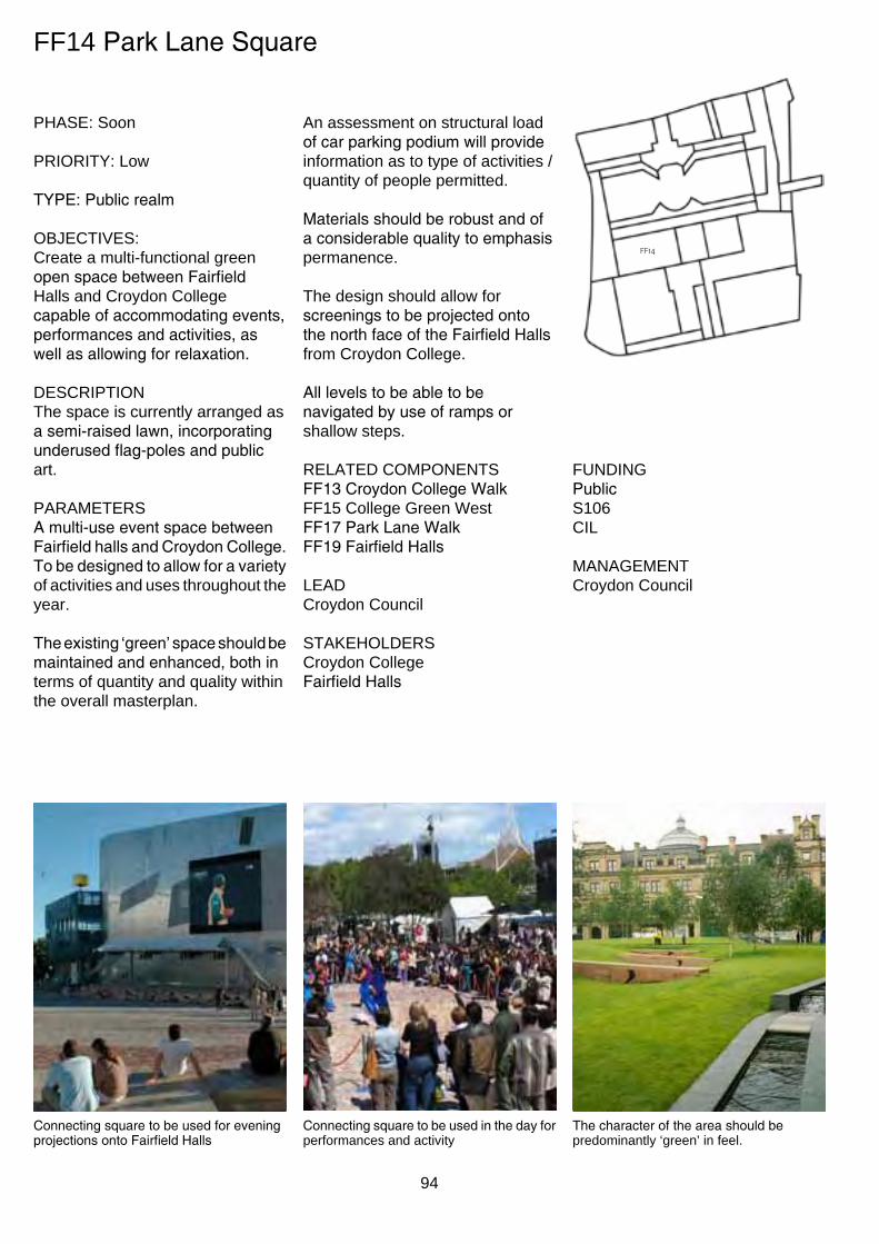
FF14 Park Lane Square
phAse: soon
prIorITY: Low
TYPE: Public realm
oBJeCTIves: Create a multi-functional green open space between Fairfield halls and Croydon College capable of accommodating events, performances and activities, as well as allowing for relaxation.
desCrIpTIon The space is currently arranged as a semi-raised lawn, incorporating underused flag-poles and public art.
pArAmeTers A multi-use event space between Fairfield halls and Croydon College. To be designed to allow for a variety of activities and uses throughout the year.
The existing ‘green’ space should be maintained and enhanced, both in terms of quantity and quality within the overall masterplan.
An assessment on structural load of car parking podium will provide information as to type of activities / quantity of people permitted.
Materials should be robust and of a considerable quality to emphasis permanence.
The design should allow for screenings to be projected onto the north face of the Fairfield Halls from Croydon College.
All levels to be able to be navigated by use of ramps or shallow steps.
reLATed ComponenTs FF13 Croydon College Walk FF15 College Green West FF17 Park Lane Walk FF19 Fairfield Halls
LeAd Croydon Council
sTAKehoLders Croydon College Fairfield Halls
FF14
FundInG Public s106 CIL
mAnAGemenT Croydon Council
Connecting square to be used for evening projections onto Fairfield Halls
Connecting square to be used in the day for performances and activity
The character of the area should be predominantly ‘green’ in feel.
94
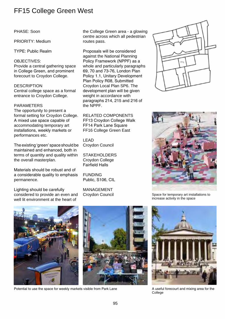
FF15 College Green West
phAse: soon
prIorITY: medium
TYPE: Public Realm
oBJeCTIves: provide a central gathering space in College Green, and prominent forecourt to Croydon College.
desCrIpTIon Central college space as a formal entrance to Croydon College.
pArAmeTers The opportunity to present a formal setting for Croydon College. A mixed use space capable of accommodating temporary art installations, weekly markets or performances etc.
The existing ‘green’ space should be maintained and enhanced, both in terms of quantity and quality within the overall masterplan.
Materials should be robust and of a considerable quality to emphasis permanence.
Lighting should be carefully considered to provide an even and well lit environment at the heart of
the College Green area - a glowing centre across which all pedestrian routes pass.
Proposals will be considered against the national planning Policy Framework (NPPF) as a whole and particularly paragraphs 69, 70 and 73-76, London Plan Policy 1.1, Unitary Development Plan Policy R08, Submitted Croydon Local plan sp6. The development plan will be given weight in accordance with paragraphs 214, 215 and 216 of the nppF.
reLATed ComponenTs FF13 Croydon College Walk FF14 Park Lane Square FF16 College Green east
LeAd Croydon Council
sTAKehoLders Croydon College Fairfield Halls
FundInG Public, S106, CIL
mAnAGemenT Croydon Council
FF15
space for temporary art installations to increase activity in the space
Potential to use the space for weekly markets visible from Park Lane A useful forecourt and mixing area for the College
95
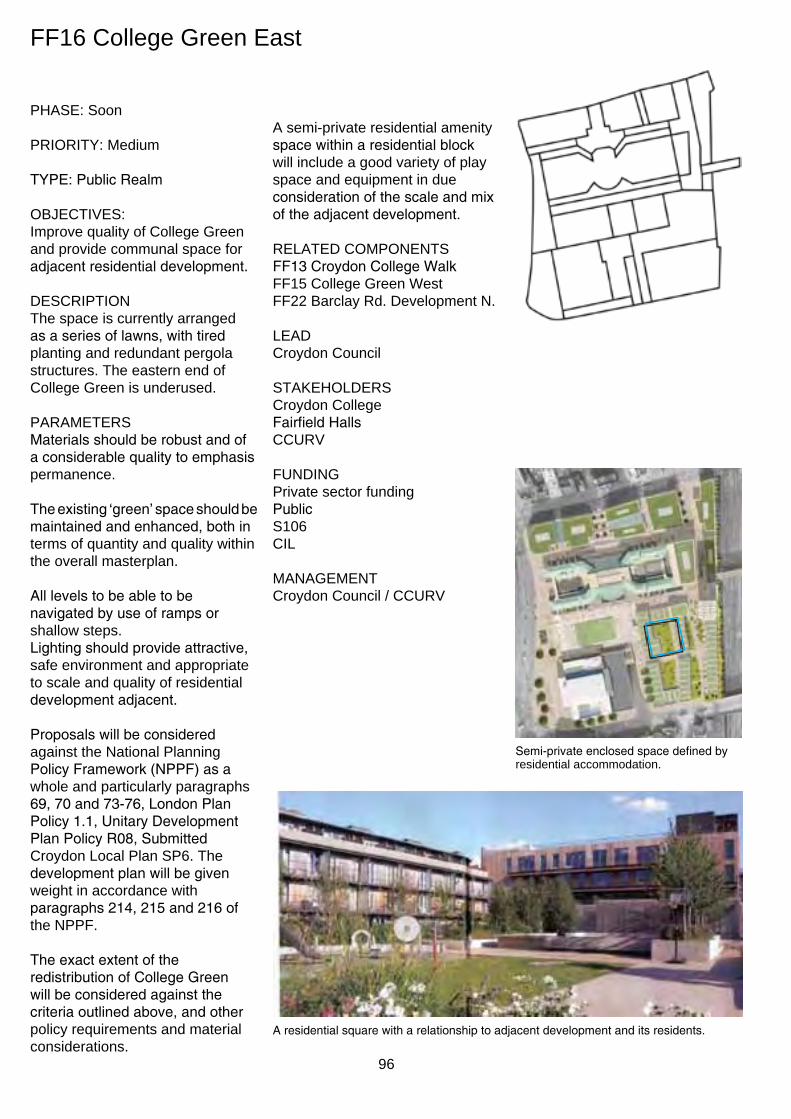
FF16 College Green east
phAse: soon
prIorITY: medium
TYPE: Public Realm
oBJeCTIves: Improve quality of College Green and provide communal space for adjacent residential development.
desCrIpTIon The space is currently arranged as a series of lawns, with tired planting and redundant pergola structures. The eastern end of College Green is underused.
pArAmeTers Materials should be robust and of a considerable quality to emphasis permanence.
The existing ‘green’ space should be maintained and enhanced, both in terms of quantity and quality within the overall masterplan.
All levels to be able to be navigated by use of ramps or shallow steps. Lighting should provide attractive, safe environment and appropriate to scale and quality of residential development adjacent.
Proposals will be considered against the national planning Policy Framework (NPPF) as a whole and particularly paragraphs 69, 70 and 73-76, London Plan Policy 1.1, Unitary Development Plan Policy R08, Submitted Croydon Local plan sp6. The development plan will be given weight in accordance with paragraphs 214, 215 and 216 of the nppF.
The exact extent of the redistribution of College Green will be considered against the criteria outlined above, and other policy requirements and material considerations.
A semi-private residential amenity space within a residential block will include a good variety of play space and equipment in due consideration of the scale and mix of the adjacent development.
reLATed ComponenTs FF13 Croydon College Walk FF15 College Green West FF22 Barclay rd. development n.
LeAd Croydon Council
sTAKehoLders Croydon College Fairfield Halls CCurv
FundInG private sector funding Public s106 CIL
mAnAGemenT Croydon Council / CCurv
FF16
Semi-private enclosed space defined by residential accommodation.
A residential square with a relationship to adjacent development and its residents.
96

KINNEAR LANDSCAPE ARCHITECTS 3rd Floor West, 1-3 Coate Street, London E2 9AG tel. 020 7729 7781 / fax. 020 7729 8809 / [email protected]
JOB: 796 Fairfield Masterplan
TITLE: Central Green_Section (1 of 2)
SCALE: 1:200@ A3 DATE: 07.02.11 DRAWING No: 796_SK007 REV: -
Croydon College
College GreenLB Un
derp
ass
Subway
TCBs
58.5m
SECTION 1:200
KEY PLAN 1:1000
SE
CTI
ON
LIN
E
WORK IN PROGRESS
FF17 Park Lane Walk
phAse: soon
prIorITY: medium
TYPE: Public Realm
oBJeCTIves: To improve the quality of the north-south link along Park Lane.
To provide a buffer to Park Lane and a fourth side to College Green.
To improve legibility of access and light to the carpark level below.
desCrIpTIon Pavement along Park Lane adjacent the western elevation of Croydon College and College Green.
pArAmeTers The use of Forest trees in this setting can deliver a unique level and scale of screening to the western end of College Green and reinforce the impression of a luxurious ‘city scale’ green space, whilst preserving an element of transparency and connectivity.
A structural analysis would identify the most appropriate areas to cut into the existing slab.
An environmental analysis would identify areas of holes required for ventilation to compensate for loss in filling in voids to FF12 Croydon College perimeter.
A revised transition between car park and podium level could thus be focused around the trees, utilising the trunks and the natural daylight as wayfinding elements from the car park.
Existing subways to be retained and refurbished with feature lighting and artwork as FF14 car park level.
The masterplan supports the relocation of bus standing away from the western edge of College Green to improve visual connectivity with the western side of Park Lane, should this be able to be accommodated satisfactorily elsewhere.
Connectivity between the Fair Field and mid Croydon masterplan areas has been significantly improved through the implementation of Connect2 pedestrian crossing over Park lane. Therefore, the detailed design of the public realm should acknowledge and enhance this greater east-west connectivity wherever possible.
FF17
reLATed ComponenTs FF4 College road FF13 Croydon College Walk FF14 Park Lane Square FF18 Fairfield Forecourt
LeAd Croydon Council
sTAKehoLders Croydon College Fairfield Halls TfL
FundInG Public s106 CIL
mAnAGemenT Croydon Council
Illustrative section through car park showing connecting Forest trees and wayfinding Pioneer trees
97

FF18 Fairfield Forecourt
phAse: now
prIorITY: high
TYPE: Public Realm
oBJeCTIves: Improve public use of Fairfield halls forecourt.
Improve visibility to the front of Fairfield Halls.
desCrIpTIon Forecourt to Fairfield Halls used for carparking and coach drop off.
pArAmeTers The use of Forest trees in this setting can deliver a unique level and scale of screening to the drop off and carparkng in front of Fairfield halls and reinforce the impression of a luxurious ‘city scale’ green space, whilst preserving an element of transparency and connectivity.
A structural analysis would identify the most appropriate areas to cut into the existing slab.
Zero loss of advertising potential to the facade of Fairfield Halls would have to be realised with the careful positioning of the trees instead framing any large scale hoardings to the face of the theatre.
option studies for revised carparking/coach drop off are
a priority for any ‘early win’ programme. The layout of the Fairfield Forecourt should accommodate disabled vehicle parking, coach and taxi drop-off, and service vehicle access to the Arnhem Gallery side of the building.
Improved pedestrian connectivity / legibility and alternative means of parking are considered of vital importance to the success of this important city address.
A reduction in car parking to the forecourt would have to be compensated for by an equivalent provision of well-lit, safe parking spaces at the lower level as close as possible to the Fairfield Halls. The Fairfield Halls would require exclusive use and management of these spaces.
Connectivity between the Fair Field and mid Croydon masterplan areas has been significantly improved through the implementation of Connect2 pedestrian crossing over Park lane. Therefore, the detailed design of the public realm should acknowledge and enhance this greater east-west connectivity wherever possible.
FF18
All lighting should be largely at low level concentrating on wayfinding, and not detracting from any feature lighting to the facade of Fairfield halls.
reLATed ComponenTs FF17 Park Lane Walk FF19 Fairfield Halls FF21 Fairfield Walk
LeAd Croydon Council
sTAKehoLders Fairfield Halls TfL
FundInG Public s106 CIL
mAnAGemenT Croydon Council Fairfield Halls TfL
Forest trees along Park Lane pedestrian friendly forecourt to theatre Trees bridging levels where possible
98
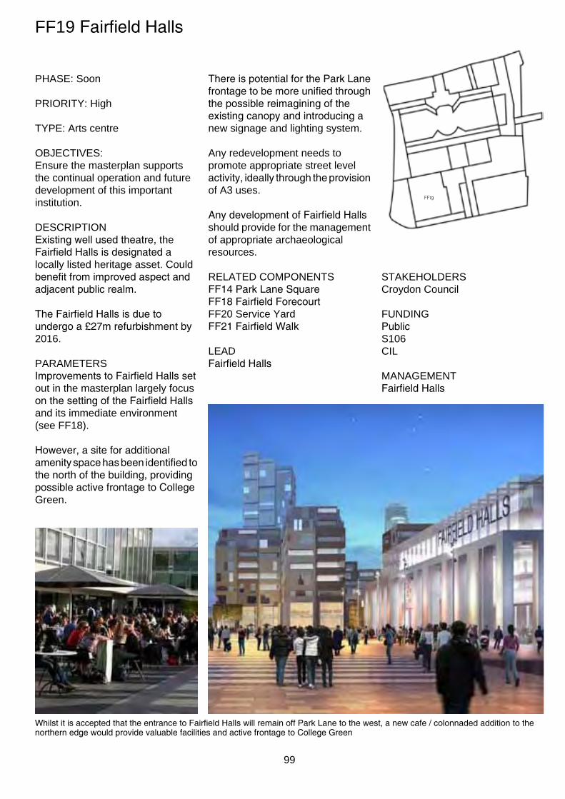
Increased engagement onto College Green, potentially through ticket sales or cafe/bar with external seating and permanent/temporary colonnade
FF19 Fairfield Halls
phAse: soon
prIorITY: high
TYpe: Arts centre
oBJeCTIves: ensure the masterplan supports the continual operation and future development of this important institution.
desCrIpTIon Existing well used theatre, the Fairfield Halls is designated a locally listed heritage asset. Could benefit from improved aspect and adjacent public realm.
The Fairfield Halls is due to undergo a £27m refurbishment by 2016.
pArAmeTers Improvements to Fairfield Halls set out in the masterplan largely focus on the setting of the Fairfield Halls and its immediate environment (see FF18).
However, a site for additional amenity space has been identified to the north of the building, providing possible active frontage to College Green.
There is potential for the Park Lane frontage to be more unified through the possible reimagining of the existing canopy and introducing a new signage and lighting system.
Any redevelopment needs to promote appropriate street level activity, ideally through the provision of A3 uses.
Any development of Fairfield Halls should provide for the management of appropriate archaeological resources.
reLATed ComponenTs FF14 Park Lane Square FF18 Fairfield Forecourt FF20 service Yard FF21 Fairfield Walk
LeAd Fairfield Halls
FF19
sTAKehoLders Croydon Council
FundInG Public s106 CIL
mAnAGemenT Fairfield Halls
Whilst it is accepted that the entrance to Fairfield Halls will remain off Park Lane to the west, a new cafe / colonnaded addition to the northern edge would provide valuable facilities and active frontage to College Green
99
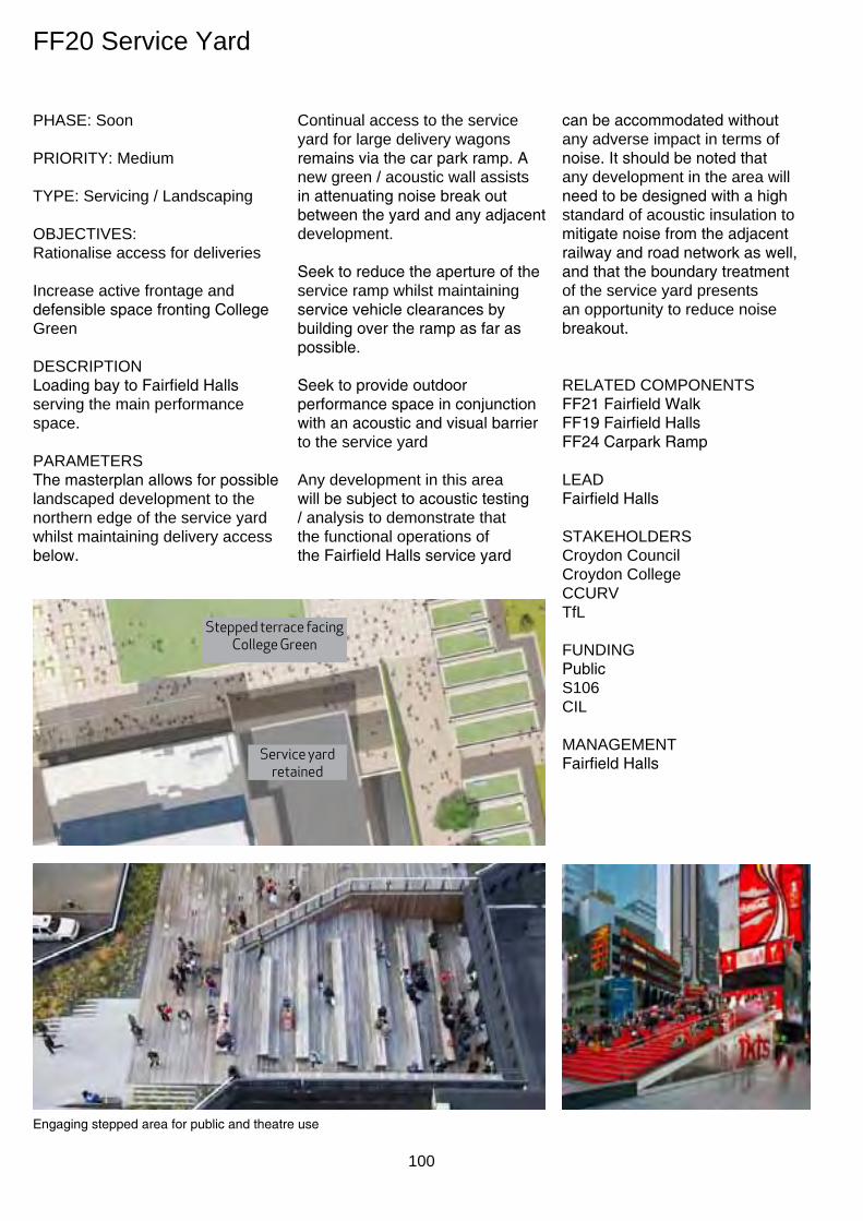
FF20 service Yard
phAse: soon
prIorITY: medium
TYpe: servicing / Landscaping
oBJeCTIves: rationalise access for deliveries
Increase active frontage and defensible space fronting College Green
desCrIpTIon Loading bay to Fairfield Halls serving the main performance space.
pArAmeTers The masterplan allows for possible landscaped development to the northern edge of the service yard whilst maintaining delivery access below.
Continual access to the service yard for large delivery wagons remains via the car park ramp. A new green / acoustic wall assists in attenuating noise break out between the yard and any adjacent development.
Seek to reduce the aperture of the service ramp whilst maintaining service vehicle clearances by building over the ramp as far as possible.
Seek to provide outdoor performance space in conjunction with an acoustic and visual barrier to the service yard
Any development in this area will be subject to acoustic testing / analysis to demonstrate that the functional operations of the Fairfield Halls service yard
Service yard retained
Stepped terrace facing College Green
Engaging stepped area for public and theatre use
100
can be accommodated without any adverse impact in terms of noise. It should be noted that any development in the area will need to be designed with a high standard of acoustic insulation to mitigate noise from the adjacent railway and road network as well, and that the boundary treatment of the service yard presents an opportunity to reduce noise breakout.
reLATed ComponenTs FF21 Fairfield Walk FF19 Fairfield Halls FF24 Carpark Ramp
LeAd Fairfield Halls
sTAKehoLders Croydon Council Croydon College CCurv TfL
FundInG Public s106 CIL
mAnAGemenT Fairfield Halls

FF21 Fairfield Walk
phAse: soon
prIorITY: medium
TYPE: Public realm
oBJeCTIves: Improve east-West access along wider, greener pavement.
desCrIpTIon Public realm to Barclay Road adjacent Fairfield Halls
pArAmeTers An opportunity for significant improvement to the urban realm linking Queen’s Gardens and Park Hill drawing on the recently implemented Connect2 public realm improvements, including a new shared cycle track on the north side of Barclay road. Future proposals should build on these initial improvements
Large Forest trees could complete the aesthetic of a lush green perimeter to the Fair Field masterplan.
Materials should be robust and of a considerable quality to emphasis permanence.
Feature lighting could be utilised to accentuate the canopy of the trees at night, illuminate the public realm and advertise the presence of Fairfeld halls at the prominent junction between Park Lane and Barclay road.
Where decorative effects are employed, low energy long life sources should be specified and appropriate fittings utilised in consideration of the residential character to parts of Barclay road.
reLATed ComponenTs FF18 Fairfield Forecourt FF19 Fairfield Halls FF20 service Yard FF24 Carpark Ramp
LeAd Croydon Council
sTAKehoLders Fairfield Halls TfL
FundInG Public s106 CIL
mAnAGemenT Croydon Council TfL
FF20
FF21
Forest trees maintain a green boulevard along Barclay Road to Park Hill
101

FF22 Barclay road development north
phAse: soon
prIorITY: high
TYpe: residential/Community
oBJeCTIves: Introduce residential development to Fair Field, improving the mix and vitality of the area.
Improve activity around the Green.
Add secondary north south route.
secure replacement community use.
desCrIpTIon The development plot comprises the underused multi-storey element of the Fairfield Car Park and Croydon College Barclay Road Annexe, due to be vacated in September 2012.
pArAmeTers Incorporate a mix of townhouses, apartment blocks and taller apartment blocks. Any taller tower element(s) should be located where their shadows have the least impact on residential amenity and public open space.
Private carparking below associated with residential units and dedicated service and delivery access is to be via Station Link to the north.
materials should reinforce a strong civic presence whilst being appropriate for a residential scale,
A green roof strategy for amenity use, biodiversity and rainwater attenuation is encouraged.
Suitable design consideration should be given to the orientation of habitable rooms away from the adjacent railway. High performance facade and
acoustically attenuated mechanical ventilation should also be considered along this facade, as well as the early weathering / discolouration of any susceptible materials.
Technical compliance with a potential CmC district energy scheme and adherence to Croydon’s policy on district energy.
The impact of the adjacent plot (Croydon Courts) is to be reduced during phase 1 through the consideration of a green/art living wall.
The quality of the semi-public / semi-private urban realm is to be carefully considered, and include:
• adequate and varied play spaces for residential density and demographic
• local, intimate square/passages off College Green and pedestrian priority passages between building plots
• high quality and robust materials, planting and detailing.
The existing ‘green’ space should be maintained and enhanced, both in terms of quantity and quality within the overall masterplan.
Temporary improvements to the development site and meanwhile uses are encouraged to address vacancy in the short-term, where these can act as a catalyst for longer-term regeneration. Where possible, temporary uses should involve local institutions and benefit the surrounding community.
Any development in this area will be subject to acoustic testing / analysis to demonstrate that the functional operations of the Fairfield Halls service yard can be accommodated without any adverse impact in terms of
102
FF22
noise. It should be noted that any development in the area will need to be designed with a high standard of acoustic insulation to mitigate noise from the adjacent railway and road network as well, and that the boundary treatment of the service yard presents an opportunity to reduce noise breakout.
Incorporate a community element. The existing educational floorspace is protected by the replacement udp and Croydon Local plan policies and therefore community floorspace needs to be either re-provided or retained. The Barclay Road Annexe also offers opportunities to accommodate a temporary community use.
reLATed ComponenTs FF10 Railway Link FF13 Croydon College Walk FF16 College Green east FF23 Barclay rd. development s. FF25 Barclay Road Walk
LeAd CCurv
sTAKehoLders Croydon Council Croydon College Fairfield Halls hmCs
FundInG Public Private Joint Venture
mAnAGemenT Existing owners / CCURV
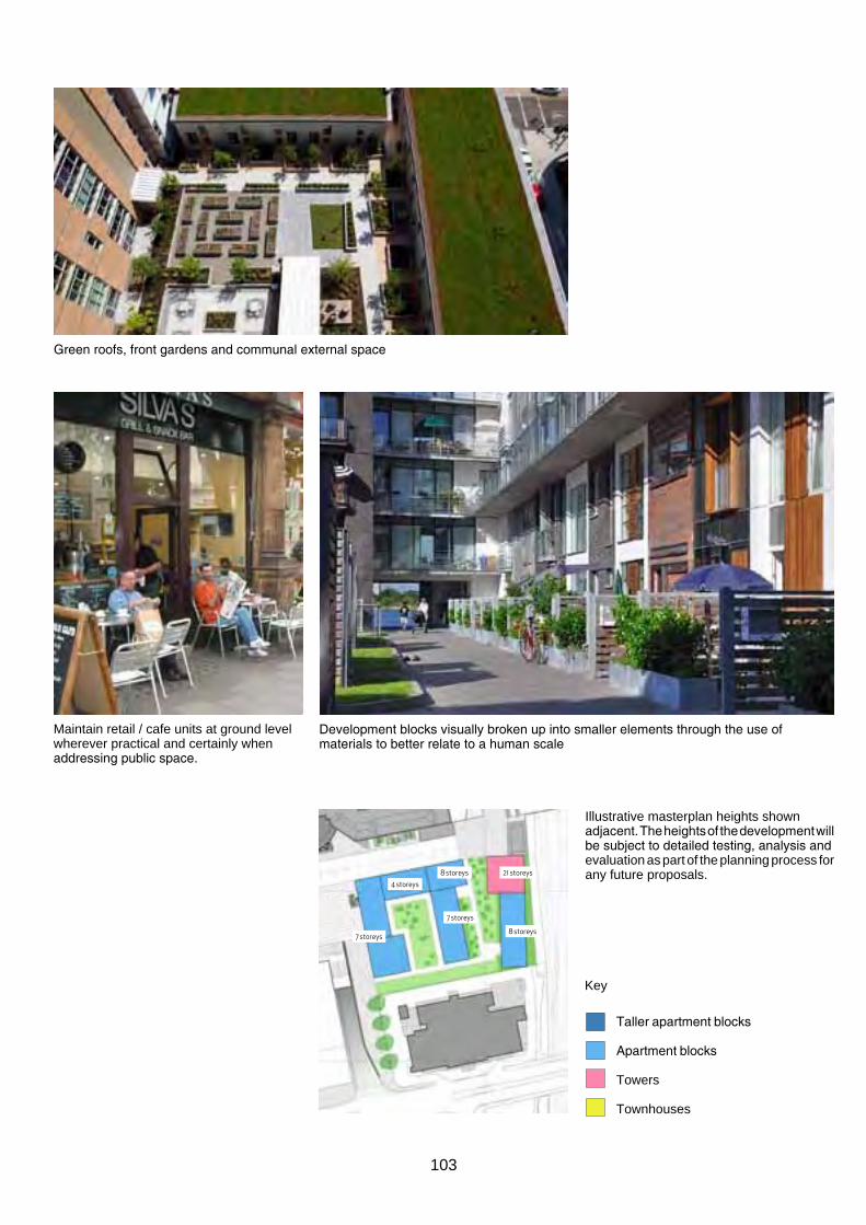
Green roofs, front gardens and communal external space
maintain retail / cafe units at ground level wherever practical and certainly when addressing public space.
Development blocks visually broken up into smaller elements through the use of materials to better relate to a human scale
8 storeys 21 storeys
7 storeys
7 storeys
4 storeys
8 storeys
Illustrative masterplan heights shown adjacent. The heights of the development will be subject to detailed testing, analysis and evaluation as part of the planning process for any future proposals.
Key
Taller apartment blocks
Apartment blocks
Towers
Townhouses
103

FF23 Barclay road development south
phAse: Later
prIorITY: medium
TYpe: residential/Community
oBJeCTIves: Introduce residential development.
Improve activity around the Green.
Add secondary north south route.
desCrIpTIon The site is currently occupied by Croydon magistrates Court. should the Courts relocate in the longer-term, the site would be suitable for residential accommodation, subject to the re-provision of community related floorspace.
pArAmeTers Incorporate a mix of townhouses, apartment blocks and taller apartment blocks. Dual aspect accommodation should be used to mitigate against inhospitable boundary conditions such as the railway.
Private carparking below associated with residential units and dedicated service and delivery access is to be via Station Link
materials should reinforce a strong civic presence whilst being appropriate for a residential scale,
A green roof strategy for amenity use, biodiversity and rainwater attenuation is encouraged.
Suitable design consideration should be given to the orientation of habitable rooms away from the adjacent railway. High performance facade and acoustically attenuated mechanical ventilation should also be considered along this facade, as well as the early weathering / discolouration of any susceptible materials.
Technical compliance with a potential CmC district energy scheme and adherence to Croydon’s policy on district energy.
The Barclay road frontage should be appropriately scaled to respect the setting of the Chatsworth Road Conservation Area, and should include active ground floor frontages.
The quality of the semi-public / semi-private urban realm is to be carefully considered, and include:
• adequate and varied play spaces for residential density and demographic
• local, intimate square/passages off College Green and pedestrian priority passages between building plots
• high quality and robust materials, planting and detailing.
The existing magistrate’s court is protected by the Replacement udp and Croydon Local plan policies and therefore community floorspace needs to be either re-provided or retained. under certain circumstances it could be released conditional to reprovision elsewhere.
FF23
reLATed ComponenTs FF22 Barclay rd. development n. FF25 Barclay Road Walk
LeAd hmCs
sTAKehoLders CCurv Croydon Council Croydon College TfL
FundInG private sector funding Public Private Joint Venture
mAnAGemenT Existing owners / Private development interests
Medium height development surrounding semi-public green communal spaces
104
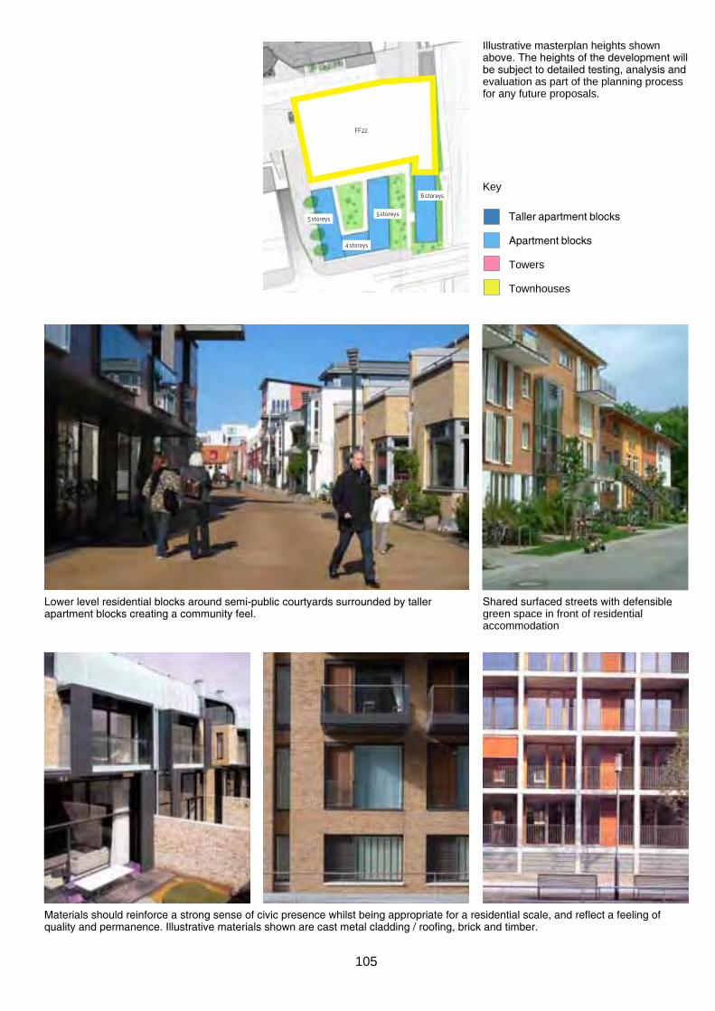
Illustrative masterplan heights shown above. The heights of the development will be subject to detailed testing, analysis and evaluation as part of the planning process for any future proposals.
Lower level residential blocks around semi-public courtyards surrounded by taller apartment blocks creating a community feel.
5 storeys 5 storeys
4 storeys
6 storeys
FF22
Key
Taller apartment blocks
Apartment blocks
Towers
Townhouses
Shared surfaced streets with defensible green space in front of residential accommodation
Materials should reinforce a strong sense of civic presence whilst being appropriate for a residential scale, and reflect a feeling of quality and permanence. Illustrative materials shown are cast metal cladding / roofing, brick and timber.
105

FF24 Car park Ramp
phAse: soon
prIorITY: medium
TYpe: Infrastructure
oBJeCTIves: reduce width / impact of car parking access road but maintain number of lanes and access / egress.
Acoustically / visually screen impact of ramp and service access from adjacent residential development.
desCrIpTIon Five lane wide ramp down to the underground carpark and current access for servicing Fairfield Halls.
pArAmeTers reduce area and visual impact of access road whilst maintaining key widths for access and servicing.
The inclusion of a living wall / acoustic screen aids protection and separation of residential development from service / access ramp.
Provide usable public space by covering over northern section of the ramp with steeped terraced feature (FF20).
Any development in this area will be subject to acoustic testing / analysis to demonstrate that the functional operations of the Fairfield Halls service yard can be accommodated without any adverse impact in terms of noise. It should be noted that any development in the area will need to be designed with a high standard of acoustic insulation to mitigate noise from the adjacent railway and road network as well, and that the boundary treatment of the service yard presents an opportunity to reduce noise breakout.
reLATed ComponenTs FF13 Croydon College Walk FF15 College Green West FF20 service Yard FF25 Barclay Road Walk LeAd Croydon Council
FF24
sTAKehoLders Fairfield Halls Croydon College CCurv nCp TfL
FundInG Public s106 CIL
mAnAGemenT nCp Croydon Council Fairfield Halls
Green wall hiding the parking ramp transforms into the terraced steps facing the Green
106

FF25 Development Walk
phAse: soon
prIorITY: medium
TYPE: Public Realm
oBJeCTIves: Introduce a grand north-south link improving access from Park Hill to College Green and east Croydon station
desCrIpTIon The Croydon College Barclay Road Annexe building is due to be vacated in September 2012.
pArAmeTers
A new landscaped boulevard, acting as a pedestrian orientated bridged link, incorporate the living art wall screening the carpark ramp and entrance (FF24) and forming one side of the new terraced steps to College Green.
Large Forest trees could complete the aesthetic of a lush green interior to the Fair Field masterplan.
Materials should be robust and of a considerable quality to emphasis permanence.
Feature lighting could be utilised to accentuate the canopy of the trees at night, illuminate the public realm and provide a lit boulevard leading to the College Green West (FF15) and College entrance beyond.
Where decorative effects are employed, low energy long life sources should be specified and appropriate fittings utilised in consideration of the adjacent residential development.
Allow for use by bicycles
Barclay Road Walk should contribute to the quantum of green open space in the masterplan area through a more generous width and additional greenery.
reLATed ComponenTs FF15 College Green West FF22 Barclay rd. development n. FF23 Barclay rd. development s. FF24 Carpark Ramp.
FF25
LeAd CCurv
sTAKehoLders Croydon Council Croydon College Fairfield Halls hmCs TfL
FundInG Public Private Joint Venture s106 CIL
mAnAGemenT Existing owners CCurv Croydon Council
A new tree-lined boulevard leading to College Green Square.
107

108

5.0
Next steps
- early wiNs
109

5.1 early wiNs proposals 5.1.1 the next steps following the masterplan are to implement projects which make something happen now in the Fair Field masterplan area in terms of improvement and regeneration in the public realm.
5.1.2 a shortlist of 5 early wins projects has been identified through engagement with stakeholders and the public:
FF6 College square FF11 station link FF13 Croydon College walk FF18 Fairfield Forecourt FF22 Meanwhile activation
College square (FF6)
5.1.3 this fundamental part of the north south link of Fair Field is a well used route and space for pedestrians in central Croydon. the regeneration of this space is focused on a link between Croydon College and george street and an urban realm with the presence of the educational institution.
5.1.4 the early win should regenerate the existing public realm with a future aspiration to extend this carpet across george street developing the legibility of this route into Fair Field via the College.
statioN liNk (FF11)
5.1.5 the current route is not legible, coherent or accessible. an improved DDa compliant visible route is required to make Fair Field part of the wider urban realm of Croydon. this will be realised through the masterplan.
5.1.6 a series of short term improvements to the legibility of the route are proposed as an early win. innovative robust lighting and painting to the existing route are proposals for improving legibility and safety of the route in the short term.
station link early win (FF11)
CroyDoN College walk (FF13)
5.1.7 the existing condition of the pavement is not acceptable in terms of access and trip hazards due to loose slabs and cracking. the pavement is envisaged as a long term connection through the Fair Field and considered important amenity space in the city. it is prioritised for refurbishment.
5.1.8 the early win proposal is for a new in situ concrete surface to be installed which is in accordance with the Croydon public realm Design guide. the existing planters are to be upgraded with new low maintenance vegetation and seating edges. robust seating provided throughout will accommodate the wide range of users.
5.1.9 proposed engagement with College students and local skaters in the detailed design process will provide integration of users and support future ownership and care of the space.
5.1.10 Croydon Council’s aspiration is for this early win to be delivered in 2013.
College square early win (FF6) 110

Croydon College walk early win (FF13)
FairFielD ForeCourt (FF18)
5.1.11 aspirations are for the frontage to Fair Field on the western boundary to become a unified pedestrian surface which give pedestrian priority and increase the visibility and access to Croydon College and Fairfield Halls.
5.1.12 the drop off has been designed with the approval of Fairfield Halls to accommodate all drop off needs.
5.1.13 a reduction in car parking to the forecourt would have to be compensated for by an equivalent provision of well-lit, safe parking spaces at the lower level as close as possible to the Fairfield Halls. The Fairfield Halls would require exclusive use and management of these spaces.
5.1.14 improvement to the fabric of the existing underground car park is considered a way in which spaces could be re provided.
Fairfield Forecourt Early Win (FF18)
MeaNwHile aCtivatioN
5.1.15 large open space in central Croydon is currently underused. there is potential for alternative uses of the multi-storey car park which uses local resources to make something happen now at Fair Field.
5.1.16 Croydon local plan sp3.5 and sp5.7 support the temporary occupation of empty buildings and cleared sites by creative industries, cultural organisations and community uses where they contribute to regeneration and enhance the character of the area
5.1.17 the engagement event held on 6th october 2012 tested the viability of meanwhile uses in spaces the Fair Field area. a programme supporting the implementation of meanwhile uses in central Croydon is currently under development.
111

5.1 early wiNs proposals
112
FF6
FF11
FF22
FF18
FF13
iMage CreDits
photographs of Croydon: Zander olson Historic Material: Croydon archives College green visulisations: wadsworth 3D
Maps reproduced by permission of ordnance survey on behalf of HMso. © Crown copyright and database right 2012. ordnance survey license number 100019257.
all reasonable efforts have been made to identify and contact copyright holders of all third-party works. any corrections should be sent to the address on this page. remaining images copyright of the consultant team/Croydon Council.
puBlisHeD By
CroyDoN CouNCil taberner House park lane Croydon Cr9 1Jt www.croydon.gov.uk enquiries: 020 8726 6000
this report is available online at: www.croydon.gov.uk/plan-ningandregeneration/croydons-planning-policy-framework/ masterplans/
issue
Dec 2012 For adoption as interim planning guidance.
113


![BOXPARK CROYDON - Bars€¦ · BOXPARK CROYDON. INTRODUCTION [03] THE CONCEPT [05] BXPARKO SHOREDITCH [07] CROYDON [16] BXPARKO CROYDON [20] DETAILS [31] CONTENTs. ELUTIONTH EvO Of](https://static.fdocuments.net/doc/165x107/5f105a3e7e708231d448afca/boxpark-croydon-bars-boxpark-croydon-introduction-03-the-concept-05-bxparko.jpg)