The extent of the Late Weichselian ice sheet in the southeastern
22
Ž . Global and Planetary Change 31 2001 453–474 www.elsevier.comrlocatergloplacha The extent of the Late Weichselian ice sheet in the southeastern Barents Sea Valery Gataullin a,1 , Jan Mangerud b,2 , John Inge Svendsen c, ) a Oil and Gas Research Institute, 5 Exporta Street, LV-1226 Riga, LatÕia b Department of Geology, UniÕersity of Bergen, Allegt. 41, N-5007 Bergen, Norway c Centre for Studies of the EnÕironment and Resources, UniÕersity of Bergen, Høyteknologisenteret, N-5020 Bergen, Norway Received 15 January 2000; accepted 23 May 2001 Abstract We have compiled a large number of seismic records and descriptions of sediment cores obtained from the southeastern Ž . Ž . Barents Sea Pechora Sea by former Soviet Union institutions. Five major seismostratigraphic units SSU-I–V were Ž . recognized. The oldest till SSU-V is mainly confined to the southernmost area and is covered by a 100–150-m-thick wedge Ž . of Middle Weichselian marine sediments SSU-IV distal to the mouth of the Pechora River. Three Late Weichselian ice sheet margins are identified on the Pechora Sea shelf. The oldest is named the Kolguev Line and it marks the southern limit Ž . of the youngest till sheet SSU-III in the Barents Sea as well as the northern, erosional limit of SSU-IV and -V. The Kolguev Line marks the maximum extension of the Barents Ice Sheet during the Late Weichselian. The Kurentsovo Line, which is located 50–100 km further to the north, is much more expressed than the Kolguev Line and corresponds with long Ž . ice-pushed bedrock ridges and till ridges. Up to 100-m-thick accumulations of glaciomarine sediments SSU-II were mapped on the southern side of the Kolguev Line whereas less than 10–20 m where found on the northern side of the inferred ice sheet margin, indicating that the ice front remained at this position for considerable time. The youngest line is the southern continuation of the Admiralty Banks moraines, which have previously been mapped along the western margin of Novaya Zemlya. The Kolguev and Kurentsovo lines were both formed by an ice sheet centered in the Barents Sea, whereas the Admiralty Banks moraines were deposited from an ice sheet over Novaya Zemlya during the final stage of the Late Weichselian, possibly during the Younger Dryas. Submerged shorelines of Late WeichselianrEarly Holocene ages have been identified on the shelf down to a water depth of 50–70 m indicating a modest glacio-isostatic depression that partly compensated the sea-level fall during the last glacial maximum. q 2001 Elsevier Science B.V. All rights reserved. Keywords: Late Weichselian; Barents Sea; ice sheet; sea level; glaciation; seismostratigraphy ) Corresponding author. Fax: q 47-55-58-9687. Ž . E-mail addresses: [email protected] V. Gataullin , Ž . [email protected] J. Mangerud , Ž . [email protected] J.I. Svendsen . 1 Currently at the Byrd Polar Research Center, Ohio State University, 1090 Carmack Rd., Columbus, OH 43210, USA. Fax: q 1-614-2924697. 2 Fax: q 47-55-58-9416. 1. Introduction Comprehensive investigations during the last decade have provided unambiguous evidence for the existence of a major Late Weichselian ice sheet on the Barents Sea shelf that inundated Svalbard and Ž . Franz Josef Land e.g. Landvik et al., 1998 . Until 0921-8181r01r$ - see front matter q 2001 Elsevier Science B.V. All rights reserved. Ž . PII: S0921-8181 01 00135-7
Transcript of The extent of the Late Weichselian ice sheet in the southeastern

Ž .Global and Planetary Change 31 2001 453–474www.elsevier.comrlocatergloplacha
The extent of the Late Weichselian ice sheet in the southeasternBarents Sea
Valery Gataullina,1, Jan Mangerudb,2, John Inge Svendsenc,)
a Oil and Gas Research Institute, 5 Exporta Street, LV-1226 Riga, LatÕiab Department of Geology, UniÕersity of Bergen, Allegt. 41, N-5007 Bergen, Norway
c Centre for Studies of the EnÕironment and Resources, UniÕersity of Bergen, Høyteknologisenteret, N-5020 Bergen, Norway
Received 15 January 2000; accepted 23 May 2001
Abstract
We have compiled a large number of seismic records and descriptions of sediment cores obtained from the southeasternŽ . Ž .Barents Sea Pechora Sea by former Soviet Union institutions. Five major seismostratigraphic units SSU-I–V were
Ž .recognized. The oldest till SSU-V is mainly confined to the southernmost area and is covered by a 100–150-m-thick wedgeŽ .of Middle Weichselian marine sediments SSU-IV distal to the mouth of the Pechora River. Three Late Weichselian ice
sheet margins are identified on the Pechora Sea shelf. The oldest is named the Kolguev Line and it marks the southern limitŽ .of the youngest till sheet SSU-III in the Barents Sea as well as the northern, erosional limit of SSU-IV and -V. The
Kolguev Line marks the maximum extension of the Barents Ice Sheet during the Late Weichselian. The Kurentsovo Line,which is located 50–100 km further to the north, is much more expressed than the Kolguev Line and corresponds with long
Ž .ice-pushed bedrock ridges and till ridges. Up to 100-m-thick accumulations of glaciomarine sediments SSU-II weremapped on the southern side of the Kolguev Line whereas less than 10–20 m where found on the northern side of theinferred ice sheet margin, indicating that the ice front remained at this position for considerable time. The youngest line isthe southern continuation of the Admiralty Banks moraines, which have previously been mapped along the western marginof Novaya Zemlya. The Kolguev and Kurentsovo lines were both formed by an ice sheet centered in the Barents Sea,whereas the Admiralty Banks moraines were deposited from an ice sheet over Novaya Zemlya during the final stage of theLate Weichselian, possibly during the Younger Dryas. Submerged shorelines of Late WeichselianrEarly Holocene ageshave been identified on the shelf down to a water depth of 50–70 m indicating a modest glacio-isostatic depression thatpartly compensated the sea-level fall during the last glacial maximum.q2001 Elsevier Science B.V. All rights reserved.
Keywords: Late Weichselian; Barents Sea; ice sheet; sea level; glaciation; seismostratigraphy
) Corresponding author. Fax:q47-55-58-9687.Ž .E-mail addresses: [email protected] V. Gataullin ,
Ž [email protected] J. Mangerud ,Ž [email protected] J.I. Svendsen .
1 Currently at the Byrd Polar Research Center, Ohio StateUniversity, 1090 Carmack Rd., Columbus, OH 43210, USA. Fax:q1-614-2924697.
2 Fax:q47-55-58-9416.
1. Introduction
Comprehensive investigations during the lastdecade have provided unambiguous evidence for theexistence of a major Late Weichselian ice sheet onthe Barents Sea shelf that inundated Svalbard and
Ž .Franz Josef Land e.g. Landvik et al., 1998 . Until
0921-8181r01r$ - see front matterq2001 Elsevier Science B.V. All rights reserved.Ž .PII: S0921-8181 01 00135-7

( )V. Gataullin et al.rGlobal and Planetary Change 31 2001 453–474454
recently, it was a common view that the southeasternmargin of this shelf-centered ice sheet expanded well
Žonto the Russian mainland Peltier, 1994; Grosswald,.1998 . New land-based data from Russia contradict
Žthis view Astakhov et al., 1999; Forman et al.,.1999; Mangerud et al., 1999 . According to a recent
Ž .reconstruction by Svendsen et al. 1999 , subse-Ž .quently supported by Forman et al. 1999 , the Late
Weichselian ice sheet terminated on the continentalshelf in the southeastern Barents Sea and along theeastern margin of the Novaya Zemlya Trough in the
Ž .Kara Sea Fig. 1 . Ongoing land-based investigationsindicate that the Russian mainland was inundated bytwo preceding ice sheet advances after the last inter-
Žglacial, one during the Early Weichselian 80–100. Žka and another during the Middle Weichselian 50–
. Ž60 ka Alexanderson et al., 2001; Henriksen et al.,2001; Houmark-Nielsen et al., 2001; Mangerud et
.al., 2001 .
In order to locate and document the Late Weich-selian ice sheet boundary, we have investigated alarge volume of geological and geophysical datafrom the continental shelf in the southeastern corner
Ž .of the Barents Sea, the Pechora Sea Figs. 1 and 2 .The Quaternary deposits in this region have previ-ously been investigated in connection with geotech-nical exploration of oil- and gas-prone fieldsŽKrapivner et al., 1988; Onishenko and Bondarev,1988; Okuneva and Gataullin, 1990; Melnikov and
.Spesivcev, 1995; Melnikov et al., 1997 . Here, wepresent a reinterpretation of the seismic profiles em-phasizing the ice sheet history. The sedimentologicaland stratigraphic interpretations were verified byborehole data. The distribution of glacial and marinesediments has been used to ascertain the Late Weich-selian ice sheet extent. Age constrains based on aseries of AMS dates from selected boreholes are
Ž .presented in a separate paper by Polyak et al. 2000 .
Fig. 1. Map of the Barents and Kara Seas showing the maximum ice sheet limits during EarlyrMiddle Weichselian and Late WeichselianŽ .according to Svendsen et al. 1999 . The approximate location of the Admiralty Bank moraines to the west of Novaya Zemlya is from
Ž .Gataullin and Polyak 1997b . The study area in the Pechora Sea is framed.
( )V. Gataullin et al.rGlobal and Planetary Change 31 2001 453–474 455
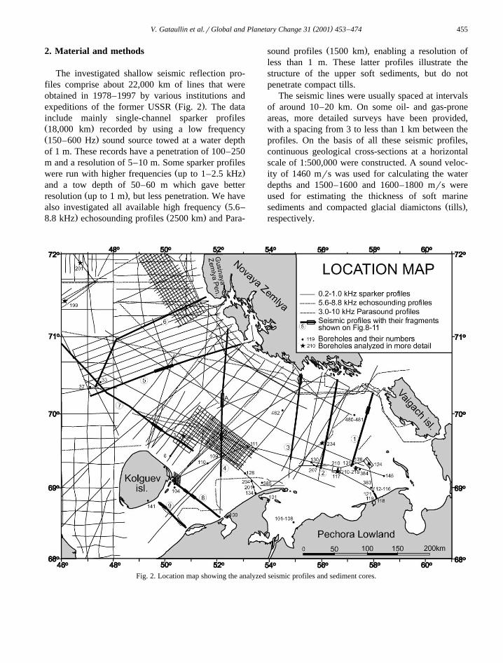
2. Material and methods
The investigated shallow seismic reflection pro-files comprise about 22,000 km of lines that wereobtained in 1978–1997 by various institutions and
Ž .expeditions of the former USSR Fig. 2 . The datainclude mainly single-channel sparker profilesŽ .18,000 km recorded by using a low frequencyŽ .150–600 Hz sound source towed at a water depthof 1 m. These records have a penetration of 100–250m and a resolution of 5–10 m. Some sparker profiles
Ž .were run with higher frequencies up to 1–2.5 kHzand a tow depth of 50–60 m which gave better
Ž .resolution up to 1 m , but less penetration. We haveŽalso investigated all available high frequency 5.6–
. Ž .8.8 kHz echosounding profiles 2500 km and Para-
Ž .sound profiles 1500 km , enabling a resolution ofless than 1 m. These latter profiles illustrate thestructure of the upper soft sediments, but do notpenetrate compact tills.
The seismic lines were usually spaced at intervalsof around 10–20 km. On some oil- and gas-proneareas, more detailed surveys have been provided,with a spacing from 3 to less than 1 km between theprofiles. On the basis of all these seismic profiles,continuous geological cross-sections at a horizontalscale of 1:500,000 were constructed. A sound veloc-ity of 1460 mrs was used for calculating the waterdepths and 1500–1600 and 1600–1800 mrs wereused for estimating the thickness of soft marine
Ž .sediments and compacted glacial diamictons tills ,respectively.
Fig. 2. Location map showing the analyzed seismic profiles and sediment cores.
()
V.G
ataullinet
al.rG
lobalandP
lanetaryC
hange31
2001453
–474
456
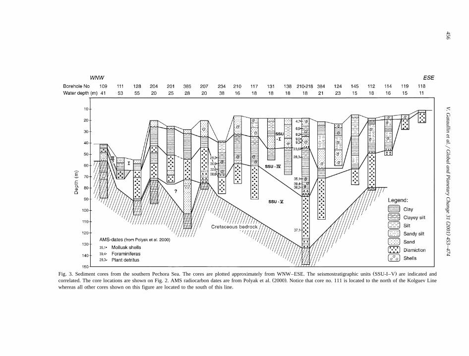
Ž .Fig. 3. Sediment cores from the southern Pechora Sea. The cores are plotted approximately from WNW–ESE. The seismostratigraphic units SSU-I–V are indicated andŽ .correlated. The core locations are shown on Fig. 2. AMS radiocarbon dates are from Polyak et al. 2000 . Notice that core no. 111 is located to the north of the Kolguev Line
whereas all other cores shown on this figure are located to the south of this line.

( )V. Gataullin et al.rGlobal and Planetary Change 31 2001 453–474 457
Interpretation of seismic profiles in the shallowPechora Sea is complicated by numerous multiples.Moreover, according to our interpretation the Quater-nary sediments are often gas-saturated andror frozen.The mapping of areas shallower than 40–50 m istherefore primarily based on sediment core data ob-tained from approximately 50 boreholes drilled by
Ž .Arctic Marine Geotechnical Expedition AMIGE ,Ž .Murmansk, Russia Fig. 2 . A selection of these
cores is shown on Fig. 3 and some are indicated onŽ .the seismic profiles Figs. 9–12 . The average length
of the boreholes is 50–70 m, maximum 130 m, butnot all of them penetrated into the pre-Quaternary
bedrock. The core diameter is 76–89 mm, the corerecovery varies from 40% to 100% depending on thelithology. Descriptions of sedimentary structures andmeasurements of physical properties, such as den-sity, water content and undrained shear strength,were performed on board the ship for all boreholesŽAMIGE and Research Institute for Marine Geology
.and Geophysics, Riga, Latvia, unpublished reports .Ž .Some bore-holes marked in Fig. 2 by a star were
investigated in more detail using magnetic suscepti-bility, grain size, mineralogical composition, petrog-raphy and roundness of stones, geochemistry and
Ž .biostratigraphy Gataullin, 1992 . Samples from key
Fig. 4. Bathymetric map constructed from the geophysical and navigation data. Inferred Late Weichselian ice sheet limits are indicated withsolid lines. The locations of described submerged shorelines in the southern Pechora Sea are also marked.

( )V. Gataullin et al.rGlobal and Planetary Change 31 2001 453–474458
boreholes were recently AMS radiocarbon datedŽ .Polyak et al., 2000 .
Based on the continuous tracing of seismicboundaries, we have constructed a bathymetric mapŽ .Fig. 4 and four isopach maps showing the thicknessand distribution of the main seismostratigraphic unitsŽ .Figs. 5–8 . All maps were compiled in a digitizedMercator projection at a working scale of 1:500,000.
3. Bathymetry
Most of the investigated area is shallower than100 m and is characterized by a flat and even seafloor bounded by the Geese Trough and the SouthernNovaya Zemlya Trough where the water depths reach
Ž .200–300 m Fig. 4 . The slopes of the NovayaZemlya Trough are steep on the Novaya Zemlya sideand gentle on the other. At the southern end ofNovaya Zemlya, the coastline is strongly indentedwith numerous bays, ledges and small islands sub-parallel to the general geological structures. TheKara Gate Strait between Novaya Zemlya andVaigach Island is an S-shaped, 5–10-km-wide chan-nel with a sill water depth of 105–110 m. The seafloor topography in this channel is very uneven withmany sub-parallel troughs and rough ridges reflect-ing the underlying bedrock structures, indicating athin and discontinuous cover of marine and glacialsediments.
4. Seismic stratigraphy and sediment distribution
4.1. Pre-Quaternary bedrock
Precambrian granites and gneisses outcrop nearŽthe Kola Peninsula west of the study area Okulitch
.et al., 1989 . Paleozoic terrigenous and carbonaceousrocks, Triassic red clay- and silt stone and Jurassicblack clay-, silt- and sand stones occur in narrowzones along the Kola–Timan coast of mainland Rus-sia and along Novaya Zemlya. In the rest of thePechora Sea, the Quaternary sequence is underlainby Cretaceous sediments comprising more than 2000m in thickness and consisting of dark gray clay, silt
Žand sand Geologija SSSR, 1970; Gramberg, 1988;.Okulitch et al., 1989 .
4.2. Glaciotectonic deformation of the bedrock
The borings show that the lower part of thesampled bedrock sediments have an undisturbed hor-izontal bedding. Above, there are small folds thatgradually increase in size upwards, and mylonitized
Ž .fractures dipping 25–408 become frequent. Withinthe uppermost 5–10 m, the bedrock is often stronglydeformed and displays a banded structure distinctlydifferent from the primary bedding. Small thrustfaults, disharmonic drag and flow folds are common.These features indicate that the bedrock has experi-
Ženced a strong shear stress from glacial flow Gataul-.lin et al., 1993; Gataullin and Polyak, 1997a . On
several seismic profiles, parallel dipping reflectorswithin the Cretaceous sequence become abruptlyfractured near the surface of the bedrock. We inter-pret all these features as the result of glacio-tectonicdislocation of the pre-Quaternary strata. In the areawith Triassic rocks, the glacio-tectonic deformationsare confined to a thin zone, usually not exceeding 1m, whereas in the soft Cretaceous sediments thedeformed zone may be as thick as 20–25 m.
4.3. Quaternary deposits
The base of the Quaternary deposits, which areresting on Mesozoic strata, is normally recognized asan erosional unconformity that corresponds with the
Ž .so-called Upper Regional Unconformity URU inŽthe western Barents Sea Solheim and Kristoffersen,
.1984 . The thickness of the Quaternary sequencevaries from a few meters in the northern part of thestudy area to more than 100 m further south. In thenorthwestern part, we have mapped three major seis-mostratigraphic units, SSU-I–III, which have been
Žpreviously distinguished in the Barents Sea Epshteinand Gataullin, 1993; Gataullin et al., 1993; Polyak et
.al., 1995 . These units were interpreted as HoloceneŽ .marine sediments SSU-I , Late Weichselian glacio-Ž .marine sediments SSU-II , and Late Weichselian till
Ž .SSU-III . In the southeastern Pechora Sea, we haveidentified two additional units, SSU-IV and -V, whichappear to be older. A description of all units is givenbelow.
( )V. Gataullin et al.rGlobal and Planetary Change 31 2001 453–474 459
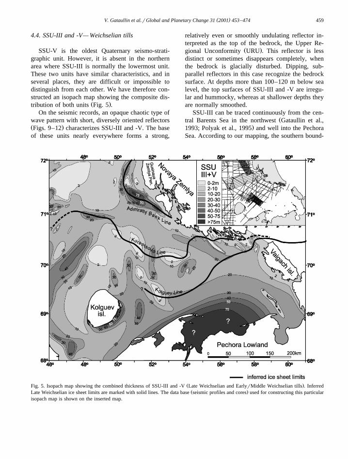
4.4. SSU-III and -V— Weichselian tills
SSU-V is the oldest Quaternary seismo-strati-graphic unit. However, it is absent in the northernarea where SSU-III is normally the lowermost unit.These two units have similar characteristics, and inseveral places, they are difficult or impossible todistinguish from each other. We have therefore con-structed an isopach map showing the composite dis-
Ž .tribution of both units Fig. 5 .On the seismic records, an opaque chaotic type of
wave pattern with short, diversely oriented reflectorsŽ .Figs. 9–12 characterizes SSU-III and -V. The baseof these units nearly everywhere forms a strong,
relatively even or smoothly undulating reflector in-terpreted as the top of the bedrock, the Upper Re-
Ž .gional Unconformity URU . This reflector is lessdistinct or sometimes disappears completely, whenthe bedrock is glacially disturbed. Dipping, sub-parallel reflectors in this case recognize the bedrocksurface. At depths more than 100–120 m below sealevel, the top surfaces of SSU-III and -V are irregu-lar and hummocky, whereas at shallower depths theyare normally smoothed.
SSU-III can be traced continuously from the cen-Žtral Barents Sea in the northwest Gataullin et al.,
.1993; Polyak et al., 1995 and well into the PechoraSea. According to our mapping, the southern bound-
Ž .Fig. 5. Isopach map showing the combined thickness of SSU-III and -V Late Weichselian and EarlyrMiddle Weichselian tills . InferredŽ .Late Weichselian ice sheet limits are marked with solid lines. The data base seismic profiles and cores used for constructing this particular
isopach map is shown on the inserted map.

( )V. Gataullin et al.rGlobal and Planetary Change 31 2001 453–474460
ary of SSU-III corresponds with the Kolguev LineŽ .Fig. 5, see below . SSU-V is mostly confined to thesoutheastern part of the Pechora Sea where it isunderlying SSU-IV. To the northwest, this unit canbe traced underneath SSU-III for some distance andis seen sporadically on the profiles from the areasfarther north.
The sediment cores show that SSU-V and -III arecomposed of firm, dark-grey, muddy diamictons with
Ž .a pebble )10 mm content of up to 5–6%. Thediamictons are usually overconsolidated, with bulkdensities of up to 2.3 grcm3 and a low water contentŽ .10–20% of wet weight . The lowermost parts of theunits often contain detached and deformed blocks of
Ž .soft local Mesozoic mainly Cretaceous deposits,reflecting subglacial entrainment of the substratumŽSættem, 1990; Gataullin et al., 1993; Gataullin and
.Polyak, 1997a . Up-section, the amount of bedrockinclusions gradually diminishes and the diamictonsbecome more homogeneous with a higher content oflong transported pebbles. The hard-rock erratics con-
Ž .sist predominantly 30–40% of dark-grey and blackmicrocrystalline limestone’s, characteristic for thePaleozoic strata of Novaya Zemlya, Vaigach Islandand Pai-Khoi Ridge. In the eastern part of the Pe-chora Sea, where the diamictons are represented bySSU-V, the amount of limestone increases consider-
Žably and reaches up to 75% Gataullin, 1992;.Epshtein et al., 1999 . The pebbles are mostly angu-
lar or sub-angular with ice-grounded facets that oc-casionally are striated. The diamictons contain usu-ally broken mollusc shells as well as Quaternary andCretaceous foraminifers that display features of rede-
Žposition from older deposits cf. Hald et al., 1990;.Polyak and Mikhailov, 1996 .
Sediments with similar acoustic and lithologicalcharacteristics are found throughout the Barents Seaand are interpreted as glaciogenic sediments, mainly
Žbasal tills Solheim and Kristoffersen, 1984; Vorrenet al., 1989; Elverhøi et al., 1990; Sættem et al.,
.1992; Gataullin et al., 1993 . We interpret SSU-III asthe southern continuation of the Late Weichselian tillsheet in the Barents Sea, whereas SSU-V is consid-ered to represent an older till bed. We will notdiscuss SSU-V further in this paper, and here juststate that we correlate it with an extensive MiddleWeichselian glaciation that ended at the Markhida
ŽMoraine in the Pechora River Valley Astakhov et
al., 1999; Mangerud et al., 1999, 2001; Svendsen et.al., 1999; Henriksen et al., 2001 . In some areas,
SSU-III and -V may include iceberg turbated sedi-ments and redeposited glacial sediments. For exam-ple, the diamictic wedges to the south of KolguevIsland may be a debris flow andror a solifluction
Ž .tongue Figs. 11 and 12 . The absence of or patchydistribution of SSU-V to the north of the KolguevLine is interpreted as a result of glacial erosion bythe Late Weichselian ice sheet, subsequently deposit-ing SSU-III.
4.5. SSU-IV— MiddlerLate Weichselian prodeltaicmarine sediments
SSU-IV is confined to the southern part of thestudy area where it occurs stratigraphically above
Ž .SSU-V Figs. 3 and 6 . However, we will emphasizethat the seismic signature of SSU-IV and -II aresimilar in some areas, so the apparent sharp geologi-cal limits of the two units may not always be real.On the southern slope of the Novaya ZemlyaThrough, the seismic profiles reveal a large, up to
Ž .100–150-m-thick sediment wedge Fig. 6 with pro-nounced progradational pattern of seismic signatureŽ .Fig. 9 . A similar sequence, up to 60-m thick, isfound in the Pomorsky Strait, between Kolguev Is-
Ž .land and the mainland Figs. 11 and 12 . In theshallow southern Pechora Sea, the distribution of
ŽSSU-IV is mainly based on core data Fig. 6 inset.and Figs. 2 and 3 . These cores penetrate into a dark
gray till correlated with SSU-V that is overlain byweakly laminated marine, prodeltaic mud of SSU-IV.A series of AMS dates conducted on mollusc shells,benthic foraminifers and terrestrial plant detritus fromthese sediments yielded ages in the range 23–42 kaŽ . Ž .Polyak et al., 2000 Fig. 3 . In the sediment cores,this unit is truncated by an erosional boundary andcovered by cross-stratified sand of early Holoceneage. The SSU-IV fills a valley-shaped depressionextending from the Pechora River delta towards the
Ž .Kara Gate Strait Fig. 6 . Our interpretation is thatthe lower part of this marine sequence accumulatedin relatively deep water during the Middle Weich-selian. The younger part of SSU-IV was depositedduring a northward progradation of the Pechora Riverdelta, probably reflecting a falling sea level. Due tosubsequent erosion, the exact age of the youngest

( )V. Gataullin et al.rGlobal and Planetary Change 31 2001 453–474 461
Ž .Fig. 6. Isopach map of SSU-IV MiddlerLate Weichselian marinerprodeltaic sediments . Inferred ice sheet limits are marked with solidŽ .lines. The data base seismic profiles and cores used for constructing this particular isopach map is shown on the inserted map.
part of this sequence is unknown and may extendwell into the Late Weichselian.
4.6. SSU-II— Late Weichselian glaciomarine sedi-ments
Ž .SSU-II has an uneven pounded distribution andis mainly confined to areas deeper than 40–60 mŽ .Figs. 7, 9 and 10 . Sediments of this unit onlyoccasionally fill small local depressions on till sur-faces in the shallow part of the shelf. SSU-II can betraced more continuously in deeper water with anaverage thickness of about 10–20 m. Much thickeraccumulations were recorded in paleo-depressions to
Ž .the south of the Geese Bank 100 m , to the north-
Ž .east of the Kolguev Island 50–60 m and in theŽ . ŽSouthern Novaya Zemlya Trough 75–80 m Fig.
.7 . SSU-II is easily distinguished from the underly-ing SSU-III by its clearly stratified acoustic signaturewith continuous sub-parallel, sometimes slightlywavy reflectors. In general, the sediments drape theunderlying substratum and tend to smooth out theuneven topography of the till surface. Thick depositson-lapping the limiting slopes characterize the cen-tral parts of the depressions. In areas shallower than90–100 m, the boundary between SSU-II and -III iseven and smooth, in contrast to areas at deeper waterdepths, which are characterized by hummocky tillsurfaces. We interpret the smooth boundary as a

( )V. Gataullin et al.rGlobal and Planetary Change 31 2001 453–474462
Ž .Fig. 7. Isopach map of SSU-II Late Weichselian glaciomarine sediments . Inferred ice sheet limits are marked with solid lines. The dataŽ .base seismic profiles and cores used for constructing this particular isopach map is shown on the inserted map.
Ž .result of marine mainly wave erosion caused by alow relative sea level during the Late Weichselian
Ž .andror Early Holocene see below .The cores show that sediments corresponding to
SSU-II in deep water consist of laminated, brownand gray clays, similar to those described in detail
Žwest of the study area Polyak et al., 1995; Polyak.and Mikhailov, 1996 . The lamination and the fact
that this unit rests directly on a till surface suggeststhat it is a glacio-marine clay that accumulated onthe sea floor in front of an ice sheet. However, aconsiderable component of these sediments may havebeen derived from erosion of the shallow areas of thePechora Sea during a lower relative sea level. Duringthe post-glacial sea level rise, the coastline and the
near-shore areas were exposed for wave erosioncausing a high sedimentation rate in offshore depres-sions. In a core from the Kurentsovo depression in
Ž .the southern part of the Geese Trough Fig. 10 , thesediments that correspond to the lower part of SSU-IIis characterized by a varve-like lamination. This,together with the absence of foraminifers, may sug-gest a glacio-lacustrine environment. In shallowerareas, the sediments are more coarse grained, and inthe southern part of the Pechora Sea, the lower partof SSU-II consist of an up to15-m-thick sandy se-
Ž .quence Fig. 10, profile 4B; profile 7, borehole 3 .SSU-II is considered to be a time transgressive unitthat accumulated in front of the retreating ice sheet.Radiocarbon dates from adjacent parts of the Barents
( )V. Gataullin et al.rGlobal and Planetary Change 31 2001 453–474 463
Sea shelf indicate that glacio-marine sedimentationŽ .SSU-II in areas to the north and west of thePechora Sea started to accumulate on the till surfaceŽ . ŽSSU-III at around 13–14 ka Polyak et al., 1995;
.Vorren and Laberg, 1996 . This age is considered asa minimum age for the base of SSU-II in the PechoraSea. The upper boundary of SSU-II is dated toaround 10–9 ka when the Holocene marine sedi-
Ž . Žments SSU-I started to accumulate Polyak et al.,.1995 .
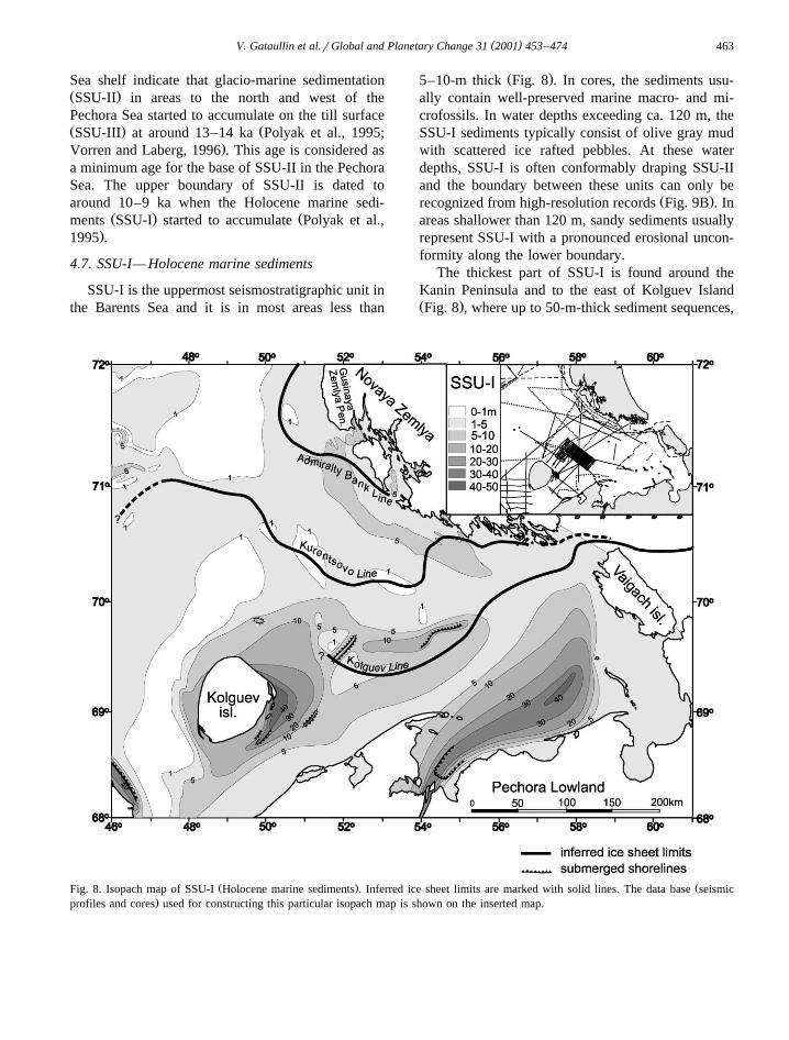
4.7. SSU-I— Holocene marine sediments
SSU-I is the uppermost seismostratigraphic unit inthe Barents Sea and it is in most areas less than
Ž .5–10-m thick Fig. 8 . In cores, the sediments usu-ally contain well-preserved marine macro- and mi-crofossils. In water depths exceeding ca. 120 m, theSSU-I sediments typically consist of olive gray mudwith scattered ice rafted pebbles. At these waterdepths, SSU-I is often conformably draping SSU-IIand the boundary between these units can only be
Ž .recognized from high-resolution records Fig. 9B . Inareas shallower than 120 m, sandy sediments usuallyrepresent SSU-I with a pronounced erosional uncon-formity along the lower boundary.
The thickest part of SSU-I is found around theKanin Peninsula and to the east of Kolguev IslandŽ .Fig. 8 , where up to 50-m-thick sediment sequences,
Ž . ŽFig. 8. Isopach map of SSU-I Holocene marine sediments . Inferred ice sheet limits are marked with solid lines. The data base seismic.profiles and cores used for constructing this particular isopach map is shown on the inserted map.

( )V. Gataullin et al.rGlobal and Planetary Change 31 2001 453–474464
Ž .Fig. 9. Interpreted seismic profiles 1 to 3 across the southern Novaya Zemlya Trough Fig. 2 , showing the distribution of theŽ .seismostratigraphic units SSU-I, -II, -III, -IV and -V . Pronounced reflectors and boundaries between seismostratigraphic units are marked
with solid lines. Poorly seen reflectors are indicated by broken lines and assumed boundaries are indicated by dotted lines. Borehole no. 207,Ž .234 and 210–218 are marked on the profiles. Upper panel A and B shows seismic profiles marked on profile 3. Small numbers given in
Ž .the boreholes are depths below the sea floor of lithological boundaries interpreted to correspond with the seismic units.

( )V. Gataullin et al.rGlobal and Planetary Change 31 2001 453–474 465
including ridges that we interpret as buried coastalŽ .bars, have been recorded Figs. 2, 11 and 12 . The
long ridges along the southern side of the PomorskyStrait, which are resting on a flat erosional surface,
Žreveal large scale internal cross stratification Fig..11 . This erosional surface has been sampled in
many cores from adjacent parts of the shelf and isnormally recognized as a sharp boundary betweenMiddle Weichselian marine mud and overlying sandysediments of Holocene age. In this area, we have notseen sediments that could be interpreted as a possibletill and there are no indications of glaciotectonic
Ž .disturbances of the underlying unit SSU-IV . An-other accumulation, up to 40-m thick, is located
Ž .outside the Pechora River delta Fig. 8 . Probablydue to permafrost andror gas saturation, the seismicdata are difficult to interpret in this shallow area, butsome profile fragments show a progradational se-
Ž .quence. The borehole data Figs. 2 and 3 suggestthat this sequence fills a broad, up to 50-km-widevalley, that is incised into the underlying sedimentsŽ .Fig. 8 . In all boreholes outside the Pechora Riverdelta, the lowermost sediments consist of cross-be-dded coarse-grained sand grading upwards into adark gray, laminated clay enriched with organic ma-terial and plant macrofossils. We interpret this as atransgressive, pro-deltaic sequence of the PechoraRiver.
Many radiocarbon dates indicate that the accumu-lation of SSU-I in the southeastern Barents Sea
Ž .started about 10–9.5 ka Polyak et al., 1995 .Holocene radiocarbon ages have also been obtainedfrom the base of SSU-I in several sediment cores
Ž .from the Pechora Sea Polyak et al., 2000, Fig. 3 .Therefore, in general, this unit is considered to be ofHolocene age, even though the lower boundary isdiachronous as a result of the Holocene transgres-sion.
4.8. Ice marginal features
Along the southwestern margin of the NovayaZemlya Trough, there is a chain of pointed ridges,20–30-km long, 2.5–10-km wide and 20–25-m highŽ .Fig. 4 . These features are characterized by a roughsurface with a series of small, 3–5-m high, irregularridges, in contrast to the surrounding flat and smoothsea floor. The seismic reflection indicates that the
ridges are composed of Cretaceous bedrock, butunlike the adjacent strata, the internal structures along
Ž .the ridge zone are indistinct Fig. 10, profile 5 . Wepostulate that this is due to intensive glaciotectonicdeformation and conclude that the ridges are icepushed and define a former ice margin that we name
Ž .the Kurentsovo Line after the Kurentsovo oil field .A pronounced east–west trending thickening of the
Ž .till cover SSU-III, Fig. 5 near the Geese Trough,interpreted as a buried end moraine, is considered to
Žrepresent a western continuation of this margin Fig..10, profile 6 . The interpretation that this line marks
a former ice sheet margin is supported by the up to100-m-thick accumulations of rhythmically bedded
Ž .sediments SSU-II, Fig. 7 south of the line whereasthe sediment cover to the north is much thinner. Thisimplies that the sediments to the north of the Kurent-sevo Line is somewhat younger than the thick accu-mulation of sediments to the south of this line, i.e.that SSU-II is a time-transgressive unit that accumu-lated in front of a retreating ice sheet. Similar icemarginal features have been identified in the westernBarents Sea where they are related to the Late
ŽWeichselian ice sheet recession Elverhøi et al.,.1990 .
We cannot fully rule out the possibility that theKurentsovo Line marks the ice front position duringthe Late Weichselian glacial maximum, but we findit more probable that it represents a retreat stage.According to our interpretation, the maximum icesheet extension is shown by the Koguev Line, some50–100 km to the south of the Kurentsevo Line.However, there are no ice marginal features or thick-ening of glaciomarine sediments associated with theKolguev Line. There are a pronounced thickening of
Ž .older marine sediments SSU-IV along the southernside of this line, but these accumulations progradedfrom the mainland and were not deposited from aformer ice sheet margin to the north. According toour interpretation of the seismic profiles, SSU-IVŽ .and also SSU-V sediments are almost totally miss-ing north of the Kolguev Line, due to the LateWeichselian glacial erosion. We therefore infer thatthe Kolguev Line represents the outermost ice sheetlimit during the Late Weichselian. However, theapparent lack of marine glaciomarine sediments infront of the Kolguev Line is difficult to understandbecause we postulate considerable glacial erosion to

()
V.G
ataullinet
al.rG
lobalandP
lanetaryC
hange31
2001453
–474
466
Ž . Ž .Fig. 10. Interpreted seismic profiles 4–7, showing the distribution of the seismostratigraphic units SSU-I, -II, -III and -V in the central part of the study area Fig. 2 .Pronounced reflectors and boundaries are marked with solid lines. Broken lines indicate poorly seen reflectors. Borehole no. 3, 32–36 and 37 are marked on the profiles.
Ž .Enlarged seismic profiles for segments of the lines are shown as insets. Small numbers given in the boreholes are depths below the sea floor of lithological boundariesinterpreted to correspond with the seismic units.
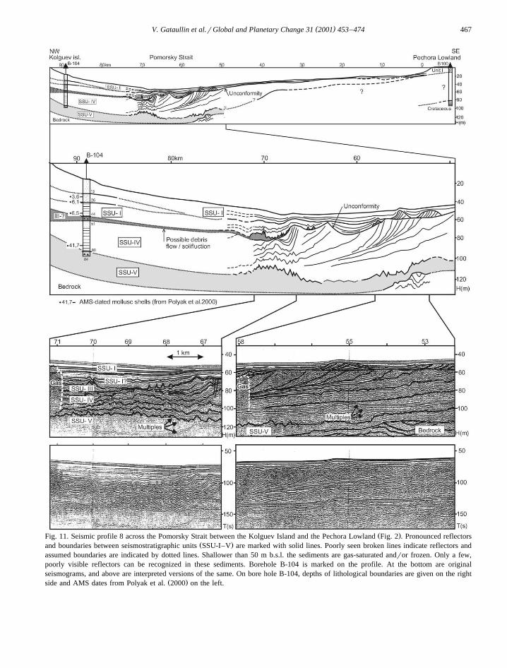
( )V. Gataullin et al.rGlobal and Planetary Change 31 2001 453–474 467
Ž .Fig. 11. Seismic profile 8 across the Pomorsky Strait between the Kolguev Island and the Pechora Lowland Fig. 2 . Pronounced reflectorsŽ .and boundaries between seismostratigraphic units SSU-I–V are marked with solid lines. Poorly seen broken lines indicate reflectors and
assumed boundaries are indicated by dotted lines. Shallower than 50 m b.s.l. the sediments are gas-saturated andror frozen. Only a few,poorly visible reflectors can be recognized in these sediments. Borehole B-104 is marked on the profile. At the bottom are originalseismograms, and above are interpreted versions of the same. On bore hole B-104, depths of lithological boundaries are given on the right
Ž .side and AMS dates from Polyak et al. 2000 on the left.
( )V. Gataullin et al.rGlobal and Planetary Change 31 2001 453–474468
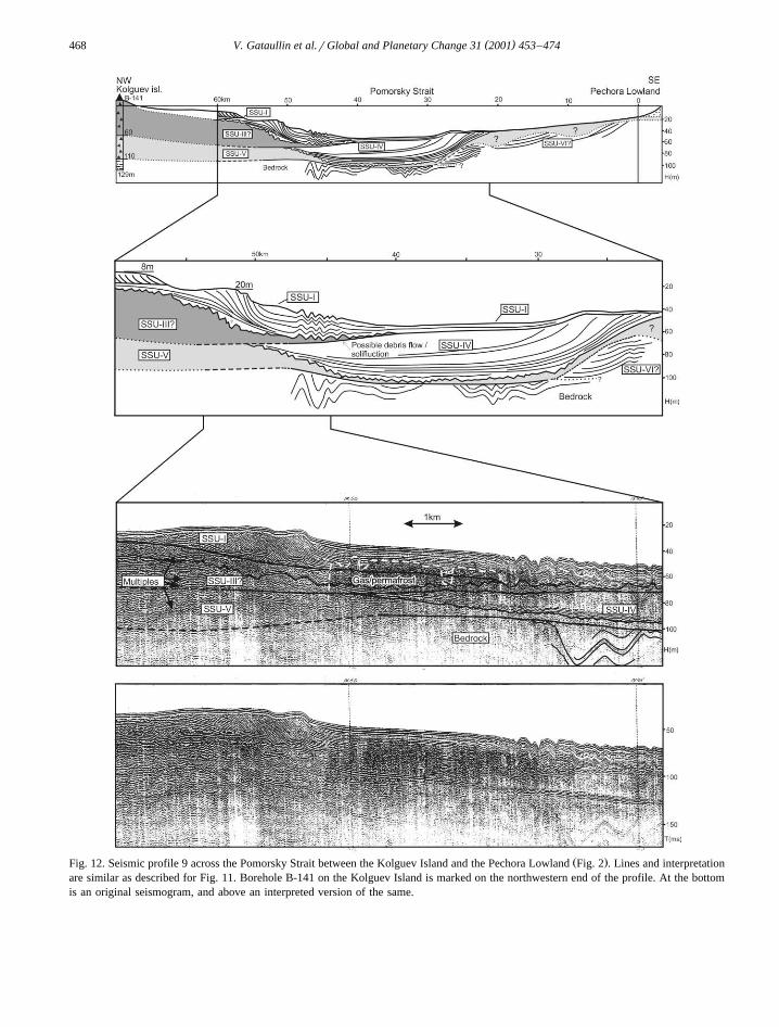
Ž .Fig. 12. Seismic profile 9 across the Pomorsky Strait between the Kolguev Island and the Pechora Lowland Fig. 2 . Lines and interpretationare similar as described for Fig. 11. Borehole B-141 on the Kolguev Island is marked on the northwestern end of the profile. At the bottomis an original seismogram, and above an interpreted version of the same.
( )V. Gataullin et al.rGlobal and Planetary Change 31 2001 453–474 469
remove units SSU-IV and -V inside the line. Withthis interpretation, we have to postulate that the iceproximal sediments that presumably accumulated infront of the ice sheet were eroded away during aperiod with low relative sea level around the Weich-selianrHolocene transition.
Outside the Gusinaya Zemlya Peninsula on No-vaya Zemlya, we have mapped a pronounced thick-ening of glaciogenic sediments that circumscribe the
Ž .coastline Figs. 5 and 10 . This arched accumulationis considered to be the southern extension of a hugeend-moraine complex that can be traced for hundredsof kilometers on the shelf to the west of Novaya
Ž .Zemlya Fig. 1 , the so-called Admiralty BankŽMoraines Epshtein and Gataullin, 1993; Gataullin
.and Polyak, 1997b . In contrast to the northern area,where the end-moraines can be seen as pronouncedridges, it is recognized mainly from the increased
Ž .thickness up to)50 m of the glaciogenic sedi-Ž .ments in the southern area Fig. 5 . There is also a
Ž .thickening of the glaciomarine sediments SSU-IIŽ .on the distal side of this line Fig. 7 . On some
seismic profiles crossing the Admiralty Bank LineŽ .Fig. 10, profile 6 , there is a weak internal reflectorinside SSU-III, which may indicate that this till unitis composed of two depositional events.
4.9. Submerged shorelines and shallow marine fea-tures
On the seismic profiles, we have identified ter-races, ridges, erosional surfaces and possible deltaicsequences that are interpreted as submerged shore-
Žlines andror shallow marine deposits Figs. 4 Figs..9–12 . These features occur at different water depths
down to at least 50–60 m below present sea level.Often they are elongated deposits along the bathy-metric contour lines. Both the seismic profiles andthe sediment cores reflect a continuous erosionalunconformity down to this level. Evidently, the ridgesare younger than this erosional surface. Here, weonly describe some of these features.
A well-defined, ca. 20-km-wide terrace is locatedat a water depth of 50 m along the southern slope of
Ž .the Novaya Zemlya Trough Fig. 9, profile 3 . Theterrace is composed of an up to 20-m-thick sequenceof large-scale cross-stratified sediments, probably
Ž .sand SSU-I . It is overlying SSU-II and -III with apronounced erosional unconformity at the base. Weinfer that the terrace is a prograding beach deposit orperhaps a delta that formed when the sea level wasabout 50 m lower than today. The erosional lowerboundary may indicate a preceding sea level as lowas 70 m below present, but this is more uncertain.
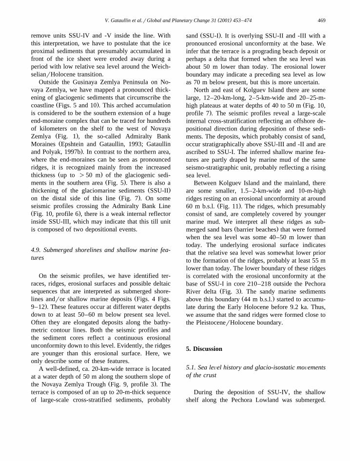
North and east of Kolguev Island there are somelarge, 12–20-km-long, 2–5-km-wide and 20–25-m-
Žhigh plateaus at water depths of 40 to 50 m Fig. 10,.profile 7 . The seismic profiles reveal a large-scale
internal cross-stratification reflecting an offshore de-positional direction during deposition of these sedi-ments. The deposits, which probably consist of sand,occur stratigraphically above SSU-III and -II and areascribed to SSU-I. The inferred shallow marine fea-tures are partly draped by marine mud of the sameseismo-stratigraphic unit, probably reflecting a risingsea level.
Between Kolguev Island and the mainland, thereare some smaller, 1.5–2-km-wide and 10-m-highridges resting on an erosional unconformity at around
Ž .60 m b.s.l. Fig. 11 . The ridges, which presumablyconsist of sand, are completely covered by youngermarine mud. We interpret all these ridges as sub-
Ž .merged sand bars barrier beaches that were formedwhen the sea level was some 40–50 m lower thantoday. The underlying erosional surface indicatesthat the relative sea level was somewhat lower priorto the formation of the ridges, probably at least 55 mlower than today. The lower boundary of these ridgesis correlated with the erosional unconformity at thebase of SSU-I in core 210–218 outside the Pechora
Ž .River delta Fig. 3 . The sandy marine sedimentsŽ .above this boundary 44 m b.s.l. started to accumu-
late during the Early Holocene before 9.2 ka. Thus,we assume that the sand ridges were formed close tothe PleistocenerHolocene boundary.
5. Discussion
5.1. Sea leÕel history and glacio-isostatic moÕementsof the crust
During the deposition of SSU-IV, the shallowshelf along the Pechora Lowland was submerged.

( )V. Gataullin et al.rGlobal and Planetary Change 31 2001 453–474470
The occurrence of Middle Weichselian marine siltŽand clay up to a water depth of around 20 m cores
.112 and 114, Fig. 3 indicates that the contempora-neous sea level was higher and that the seafloor atthis time was below the wave base. This assumptionis supported by the fact that SSU-IV is even more
Ž .fine-grained than Holocene sediments SSU-I atŽ .comparable water depths Fig. 3 . However, observa-
tions from coastal sections indicate that relative sealevel has not been higher than today during the last
Ž .30–40 ka Mangerud et al., 1999 . We thereforeconclude that the relative sea level during the Mid-dlerLate Weichselian transition was between 0 andy20 m. The prograding SSU-IV indicates that thesea level was falling during deposition of this unit.Probably, the highest relative sea level occurred
Žshortly after the preceding deglaciation from the.Markhida Moraine some 40–60,0000 years ago
Ž .Magerud et al., 2001 . The youngest date on marinemolluscs from SSU-IV is 29.3 ka from about 50 m
Ž .b.s.l. Core 234, Fig. 3 . However, also the date 23.6Ž .ka on plant detritus core 234, Fig. 3 is probably
from marine sediments.We have not been able to identify shorelines that
can be correlated with the Late Weichselian glacialmaximum; all mapped beaches and shallow marinefeatures seems to be younger. During the glacialmaximum and the first retreat phases, fine-grained
Ž .glaciomarine sediments SSU-II accumulated on thetill surfaces of SSU-III up to at least 50 m b.s.l.,which implies that the relative sea level was higherthan this during the early stage of deglaciation.
SSU-IV, -III, and partly of -II are truncated by apronounced erosional unconformity that can be traced
Ždown to 60–70 m below the present sea level Fig..11 . Off shore the Pechora River, this unconformity
forms a more than 40-m-deep valley, probably in-cised into SSU-V–IV by fluvial erosion, and subse-
Ž .quently filled with Holocene sediments Fig. 8 .Deposits interpreted as beach sediments have beenrecognized on the seismic profiles down to water
Ždepths of 50–60 m Fig. 9, profile 3 and Fig. 10,.profile 7 . The fact that the till surface at these sites
is smoothed above and hummocky below 60–70 m,supports the conclusion that lowest relative sea leveloccurred after the late Weichselian glacial maximum.We conclude that the late Weichselian minimumrelative sea level in the southern Pechora Sea was
between 50 and 70 m below the present. Nearly allareas to the south of the Kolguev Line are shallower
Ž .than 60 m Fig. 4 and were sub-aerially exposedduring this low-stand. As long as the ice sheetblocked the drainage across the Barents Sea shelf inthe north and west, the only connection to the oceanwas through the Kara Gate Strait between NovayaZemlya and Vaigach Island. The occurrence of lit-toral sediments at a water depth of 50 m cutting
Ž .deeper water facies of SSU-II Fig. 9, profile 3indicates a drop in relative sea level after the icesheet recession had started. The regression minimumwas presumably attained at the final stage of the LateWeichselian or even during the Early Holocene.
After the period with low relative sea level, theshelf was again transgressed when SSU-I accumu-lated. A series of radiocarbon dates from core 210–
Ž .218 Fig. 3 shows that marine sediments started toaccumulate on the erosional surface at 44 m b.s.l.
Ž .shortly before 9.2 ka Polyak et al., 2000 . In severalcores from offshore the Pechora Lowland, Veinbergs
Ž .et al. 1995 report that the marine sediments areunderlain by terrestrial peat of Holocene age. In onecore from a water depth of 15–17 m, a 0.4-m-thickpeat layer was radiocarbon dated to ca. 10 ka show-ing that much of the sea level rise occurred duringthe Holocene. Drowned Holocene peat below sealevel has also been found along the coast, which ispresently submerging at a rate of 2.4 mm per yearŽ .Nikonov, 1980 .
From the evidence discussed above, we have con-structed a relative sea level curve for the southern
Ž .Pechora Sea Fig. 13 . We infer that there was agradual lowering of the sea level from 30 ka until thefinal stage of the Late Weichselian when the regres-sion rate accelerated. Minimum sea level at around60 m b.s.l. was probably attained 12–10 ka. A rapidsea level rise occurred during the Early Holocenewith a slow down from about 7 to 8 ka. Realizing theuncertainties in both dating and depths, we stillbelieve the curve outline the main pattern of the sealevel changes.
The observed sea level variations in the PechoraŽ .Sea is significantly different from the eustatic global
sea level changes during the last 35 ka, which implysome glacio-isostatic movements in the Pechora Sea.The amplitude of the isostatic movements can bereconstructed by subtracting the eustatic from the

( )V. Gataullin et al.rGlobal and Planetary Change 31 2001 453–474 471
Ž .Fig. 13. A Inferred relative sea level curve for the southernŽ .Pechora Sea for the last 35 ka. B Eustatic sea level curve,
Ž .simplified from Chapell and Shacleton 1986 and FairbanksŽ . Ž . Ž .1989 . C The resultant isostatic curve when B is subtracted
Ž .from A .
Ž .local sea level Fig. 13 . The resultant curve reflectsa glacio-isostatic depression of the crust in the orderof 40–50 m during the period from 30 to 20 ka,
followed by a rapid rebound during the Late Weich-selian deglaciation. Most of the uplift was accom-plished by 10 ka and during the Early Holocene, theuplift was apparently much slower. The total iso-static uplift from ca. 20 to 5 ka was in the order of100 m. During the last few thousand years, the crusthas been subsiding, causing the ongoing transgres-sion along the coast.
5.2. The ice sheet extent during the Late Weichselianglacial maximum
The sediment stratigraphy in the Pechora Seasubstantiate the conclusions from the land-based in-vestigations that the Late Weichselian ice sheetboundary was located well off the present coastlineŽ .Astakhov et al., 1999; Mangerud et al., 1999 .Thick accumulations of marine sediments of Middle
Ž .and Late Weichselian age SSU-IV and -II evidentlypostdate the last glaciation in the Pechora Sea. Ac-cordingly, the Late Weichselian ice sheet boundarymust have been located to the northwest of thissediment sequence. To identify possible ice sheetmargins in this area, we have used three independent
Ž .criteria: 1 the southern extension of the youngestŽ .till sheet in the Barents Sea; 2 the occurrence of
Ž .ice-marginal ridges; and 3 the distribution ofglaciomarine sediments. We have located three pos-sible glacier margins: From south to north, theseinclude the Kolguev Line, the Kurentsovo Line andthe Admiralty Bank Line.
Ž .The Late Weichselian till SSU-III and the over-Ž .lying glaciomarine sediments SSU-II are confi-
dently traced from the central Barents Sea to theice-pushed ridges along the Kurentsovo Line. Thepronounced thickening of SSU-II on the southernside of the ridges indicate that the ice front halted for
Ž .some time at this position Figs. 7 and 10 . SSU-II ishere up to 100-m thick, and is interpreted as consist-ing of sediments that accumulated in front of the icesheet. The Kurentsovo Line marks both morphologi-cally and sedimentologically the most distinct termi-nal position. The question is if it marks the veryoutermost position of the ice sheet margin or only aretreat stage.
According to our mapping, SSU-III continues wellbeyond the Kurentsovo Line and southward to the
Ž .Kolguev Line Fig. 10 , indicating that the limit of

( )V. Gataullin et al.rGlobal and Planetary Change 31 2001 453–474472
the Late Weichselian ice sheet was located 50–100km to the south of the Kurentsovo Line. The appar-
Ž .ent lack of Middle Weichselian sediments SSU-IVto the north of this boundary support this interpreta-
Ž .tion Fig. 6 . On the other hand, in contrast to theKurentsovo Line, ice marginal features and pro-gla-cial sediments are apparently lacking along theKolguev Line. Whether the Late Weichselian glacialmaximum is represented by the Kolguev or theKurentsevo Line is a minor uncertainty compared tomost cited alternatives the last decades.
The down warping of the crust that occurred after30 ka reflects a growing ice load in the Barents Searegion. We infer that the maximum ice sheet positionwas attained more or less simultaneously with thewestern margin of the Barents Ice Sheet about 20–15
Ž .ka Landvik et al., 1998 , but we are not yet able todetermine the exact age of this event. Our conclusionthat the ice sheet terminated off the coast explainsthe missing emerged shores along the Pechora coast,in contrast to other areas of the Barents Sea regionthat evidently were covered by the Late Weichselian
Ž .ice sheet cf. Landvik et al., 1998 .
5.3. Deglaciation
The rapid uplift, which occurred after the icesheet retreated from the maximum position, indicatethat a glacial unloading occurred at around 15–12 kaŽ .Fig. 13 . This is consistent with data from thecentral Barents Sea, which apparently was
Ždeglaciated shortly before 12.8 ka Polyak et al.,.1995 .
After the ice sheet receded from the KurentsovoLine, the ice dispersal center shifted to NovayaZemlya before the Admiralty Bank moraines weredeposited. Probably they were deposited by a localice cap centered over the Novaya Zemlya afterdeglaciation of the southeastern Barents Sea shelfŽ .Svendsen et al., 1999 . According to our mapping,these moraines seem to cross the southern part of theisland. The seismic profiles that cross the offshoremoraines may suggest that they reflect a glacier
Ž .readvance Fig. 10, profile 6 . We hypothesize thatthese moraines were formed during the YoungerDryas cooling event, but this needs to be tested byfuture investigations.
6. Conclusions
Ž .1 The maximum extent of the Barents Ice Sheetduring the Late Weichselian has been mapped on theshallow shelf from the southern tip of Novaja Zemlyatowards Kolguev Island. This line, which has beentermed the Kolguev Line, mark the southern limit of
Ž .the youngest till sheet SSU-III in the Barents Seaas well as the northern erosional limit of Middle
Ž .Weichselian marine sediments SSU-IV recorded inthe Pechora Sea.
Ž .2 Another ice sheet boundary, named theKurentsovo Line, is located 50–100 km further tothe north. The Kurentsevo Line corresponds with endmoraines, ice-pushed bedrock ridges and up to 100-m-thick accumulations of glaciomarine sedimentsŽ .SSU-II .
Ž .3 Submerged shorelines of Late WeichselianrEarly Holocene ages have been identified on theshelf down to water depths of 50–70 m. The occur-rence of fine grained Middle Weichselian marinesediments up to ca. 20 m b.s.l. indicate a sea leveldrop in the order of 30–40 m during the LateWeichselian period.
Acknowledgements
This paper is a contribution to the EuropeanCommission projectIce Sheets and Climate in the
ŽEurasian Arctic at the Last Glacial Maximum Eura-.sian Ice Sheets under theEnÕironment and Climate
ŽResearch Program ENV4-CT97-0563, Climate and.Natural Hazards and the Russian–Norwegian pro-
ject Paleo EnÕironment and Climate History of theŽ .Russian Arctic PECHORA . Both project forms part
of the European Science Foundation ProgramQua-ternary EnÕironment of the Eurasian NorthŽ .QUEEN . Valery Gataullin, financially supportedby the Norwegian Research Council, compiled seis-mic profiles and core data obtained by various re-search institutes in the former Soviet Union. Theseinclude: Research Institute for Marine Geology and
Ž .Geophysics NIIMorgeo, Riga, Latvia , Research In-stitute of Geology and Mineral Resources of the
ŽWorld Ocean VNIIOkeangeologia, St. Petersburg,. ŽRussia , All-Union Geological Institute VSEGEI,

( )V. Gataullin et al.rGlobal and Planetary Change 31 2001 453–474 473
.St. Petersburg, Russia , Shirshov’s Institute ofŽOceanology, Russian Academy of Sciences IORAN,
.Moscow, Russia , Arctic Marine Geotechnical Expe-Ž .dition AMIGE, Murmansk, Russia , Baltic Marine
ŽGeotechnical Expedition BMGE, Kaliningrad, Rus-. Žsia , Marine Arctic Geological Expedition MAGE,
.Murmansk, Russia , Polar Marine Geological Expe-Ž .dition PMGRE, Lomonosov, Russia . Jan Sverre
Laberg and an anonymous person reviewed the pa-per. To all these institutions, we offer our sincerethanks.
References
Alexanderson, H., Hjort, C., Bolshiyanov, D.Y., Moller, P.,¨Antonov, O., Fedorov, G.B., Pavlov, M., 2001. The NorthTaymyr ice-marginal zone, Arctic Siberia—a preliminaryoverview and dating. Global and Planetary Change 31, 427–445.
Astakhov, V.I., Svendsen, J.I., Matiouchkov, A., Mangerud, J.,Maslenikova, O., Tveranger, J., 1999. Marginal formations ofthe last Kara and Barents ice shelves in northern EuropeanRussia. Boreas 28, 23–45.
Chapell, J., Shacleton, N.J., 1986. Oxygen isotopes and sea level.Nature 324, 137–140.
Elverhøi, A., Nyland-Berg, M., Russwurm, L., Solheim, A., 1990.Late Weichselian ice recession in the central Barents Sea. In:
Ž .Bleil, U., Thiede, J. Eds. , Geological History of the PolarOceans: Arctic versus Antarctic. Kluwer Academic Publish-ing, Dordrecht, pp. 289–307.
Epshtein, O.G., Gataullin, V.N., 1993. Lithology and conditionsof formations of Quaternary deposits in the eastern part of the
Ž .Barents Sea Novaya Zemlya side . Lithology and MineralŽ .Resources USSR 28, 84–94.
Epshtein, O.G., Romanyuk, B.F., Gataullin, V.N., 1999. Pleis-tocene Scandinavian and Novaya Zemlya ice sheets in thesouthern Barents Sea and on the north of the Russian Plain.
ŽBulletin of the Quaternary Commission Bulleten Komissiji po. Ž .izucheniju chetvertichnogo perioda 63, 132–155 in Russian .
Fairbanks, R.G., 1989. A 17000 year glacio-eustasic sea-levelrecord: influence of glacial melting on the Youger Dryas eventand deep-ocean circulation. Nature 342, 637–642.
Forman, S., Ingolfsson, O., Gataullin, V., Manley, W.F., Lokrantz,H., 1999. Late quaternary stratigraphy of western YamalPeninsula, Russia: new constraints on the configuration of theEurasian ice sheet. Geology 27, 807–810.
Ž .Gataullin, V.N. Principal investigator 1992. Lithostratigraphicinvestigation of the key geotechnical boreholes of the Barentsand Kara seas. Unpublished Report, NIIMorgeo, Riga, Latvia,
Ž .363 pp. in Russian .Gataullin, V., Polyak, L., 1997a. Glaciotectonic features, south-
Ž .eastern Barents Sea. In: Davies, T.A., et al. Eds. , Glaciated
Continental Margins: An Atlas of Acoustic Images. Chapman& Hall, London, pp. 70–71.
Gataullin, V., Polyak, L. 1997b. Morainic ridge complex, easternŽ .Barents Sea. In: Davies, T.A., et al. Eds. , Glaciated Conti-
nental Margins: An Atlas of Acoustic Images. Chapman &Hall, London, pp. 82–83.
Gataullin, V., Polyak, L., Epshtein, O., Romanyuk, B. et al., 1993.Glacigenic deposits of the Central Deep: a key to the LateQuaternary evolution of the eastern Barents Sea. Boreas 22,47–58.
Ž . ŽGeologija SSSR, 1970. Geology of the USSR , v. XXVI Soviet.Arctic Islands. Part 1. Geological description . Nedra, Moscow,
Ž .547 pp. in Russian .Ž . ŽGramberg, I.S. Ed. , Barentsevomorskaya plita Barents Sea
. Ž .plate . Nedra, Leningrad, 263 pp. in Russian .Grosswald, M.G., 1998. Late-Weichselian ice sheets in Arctic and
Pacific Siberia. Quaternary International 45r46, 3–18.Hald, M., Sættem, J., Nesse, E., 1990. Middle and Late Weich-
selian stratigraphy in shallow drillings from the southwesternBarents Sea: foraminiferal, amino acid and radiocarbon evi-dence. Norsk Geologisk Tiddsskrift 70, 241–257.
Henriksen, M., Mangerud, J., Maslenikova, O., Matiouchkov, A.,Tveranger, J., 2001. Weichselian stratigraphy and glaciotec-tonic deformation along the lower Pechora River, Arctic Rus-sia. Global and Planetary Change 31, 297–319.
Houmark-Nielsen, M., Demidov, I., Funder, S., Grøsfjeld, K.,Kjær, K.H., Larsen, E., Lavrova, N., Lysa, A., Nielsen, J.K.,˚2001. Early and Middle Valdaian terrestrial and marine basedglaciations and periglacial interstadials in North West Russia:New evidence from the Pyoza river area. Global and PlanetaryChange 31, 215–237.
Krapivner, R.B., Gritzenko, I.I., Kostyukhin, A.I., 1988. The latecenozoic seismostratigraphy and paleogeography of the south-ern Barents Sea region. In: Matishov, G.G., Tarasov, G.A.Ž .Eds. , Chetvertichnaja Paleoekologija i Paleogeografija Sev-
Žernyh morei Quaternary Paleoecology and Paleogeography of. Žthe Northern Seas . Nauka, Moscow, pp. 103–123 in Rus-
.sian .Landvik, J.I., Bondevik, S., Elverhøi, A., Fjeldskaar, W.,
Mangerud, J., Salvigsen, O., Siegert, M.I., Svendsen, J.I.,Vorren, T.O., 1998. The Last Glacial Maximum of Svaldbardand the Barents Sea area: ice sheet extent and configuration.Quaternary Science Reviews 17, 43–75.
Mangerud, J., Svendsen, J.I., Astakhov, V.I., 1999. Age andextent of the Barents and Kara ice sheets in Northern Russia.Boreas 28, 46–80.
Mangerud, J., Astakhov, V.I., Murray, A., Svendsen, J.I., 2001.The chronology of a large ice-dammed lake and the Barents–Kara Ice Sheet advances, Northern Russia. Global and Plane-tary Change 31, 321–336.
Melnikov, V.P., Spesivcev, V.I., 1995. Inzhenerno-Geologiche-skie i Geokriologicheskie Uslovija Shelfa Barentseva i
ŽKarskogo Morei Geotechnical and geocryological conditions.of the Barents and Kara Sea shelves . Nauka, Novosibirsk, 198
Ž .pp. in Russian .Melnikov, V.P., Spesivcev, V.I., Kulikov, V.N., 1997. About jet
degasation of hydrocarbons as source of new icy formationsŽ .on the Pechora Sea shelf. In: Melnikov, E.S. Ed. , Itogi

( )V. Gataullin et al.rGlobal and Planetary Change 31 2001 453–474474
Fundamental’nyh Issledovanij Kriosfery Zemli v Arctike iSubarktike: Materialy Mezhdunarodnoi Konferenciji, Pushino
Ž1996 Results of fundamental investigations of the Earthcryosphere in the Arctic and Subarctic: Proceedings of the
.International conference, Pushino 1996 . Nauka, Novosibirsk,Ž .pp. 259–269 in Russian .
Nikonov, A.A., 1980. The present vertical displacements of theshore of the northern and far-eastern seas of the USSR.
Ž .Geologija and Geofizika Geology and Geophysics , Novosi-Ž .birsk 2, 71–78 in Russian .
Okulitch, A.V., Lopatin, B.G., Jakson, X.R., 1989. Circumpolargeological map of the Arctic. Geological Survey of Canada,Map 1765A, Scale 1:6000000.
Okuneva, O.G., Gataullin, V.N., 1990. To the question of distribu-tion of seismostratigraphic units of recent sediments in the
Ž .Pechora Sea region. In: Dzilna, I.L. Ed. , Morskaya Inzhener-Ž .naja Geologija Marine Geotechnical Geology . VNIIMorgeo,
Ž .Riga, Latvia, pp. 80–91 in Russian .Onishenko, S.V., Bondarev, V.N., 1988. Stratigraphy and paleo-
geographical features of sections in the Pechora shallows. In:Ž .Matishov, G.G., Tarasov, G.A. Eds. , Chetvertichnaja Pale-
Žoekologija i Paleogeografija Severnyh morei Quaternary Pale-.oecology and Paleogeography of the Northern Seas . Nauka,
Ž .Moscow, pp. 142–150 in Russian .Peltier, R.W., 1994. Ice age paleotopography. Science 265, 195–
201.Polyak, L., Mikhailov, 1996. Post-glacial environments of the
southern Barents Sea: foraminiferal evidence. In: Andrews,Ž .J.T., Austin, W.E.N., Bergsten, H., Jennings, A.E. Eds. , Late
Quaternary Palaeoceanography of the North Atlantic Margins.Geological Society Special Publication, vol. 11, pp. 323–337.
Polyak, L., Lehman, S.J., Gataullin, V., Jull, A.J.T., 1995. Twostep deglaciation of the southeastern Barents Sea. Geology 23,567–571.
Polyak, L., Gataullin, V., Okuneva, O., Stelle, V., 2000. Newconstraints on the limits of the Barents–Kara ice sheet during
the Last Glacial Maximum based on borehole stratigraphyfrom the Pechora Sea. Geology 28, 611–614.
Solheim, A., Kristoffersen, Y., 1984. The physical environment inthe Western Barents Sea, 1:5,000,000. Sediments above theupper regional unconformity: thickness, seismic stratigraphyand outline of the glacial history. Norsk Polarinstitutt, Skrifter179B, 1–26.
Svendsen, J.I., Astakhov, V.I., Bolshiyanov, D.Yu., Demidov, I.,Dowdeswell, J.A., Gataullin, V., Hjort, Ch., Hubberten, H.W.,Larsen, E., Mangerud, J., Melles, M., Moller, P., Saarnisto,¨M., Siegert, M.J., 1999. Maximum extent of the Eurasian icesheet in the Barents and Kara Sea region during the Weich-selian. Boreas 28, 234–242.
Sættem, J., 1990. Glaciotectonic forms and structures on theNorwegian continental shelf: observations, processes, and im-plications. Norsk Geologisk Tidsskrift 70, 81–94.
Sættem, J., Poole, D.A.R., Sejrup, H.P., Ellingsen, K.L., 1992.Glacial geology of outer Bjørnøyrenna, western Barents Sea.Marine Geology 103, 15–51.
Veinbergs, I.G., Stelle, V.Ya., Savvaitov, A.S., Yakubovskaya,I.Ya., 1995. Late quaternary history of the pechora sea coast.
Ž .In: Svitoch, A.A. Ed. , Korreljacija PaleogeograficheskihŽSobytij: Materik-Shelf-Okean Correlation of paleogeographi-.cal events: continent-shelf-ocean . Proceedings of the Confer-
ence, Moscow State University, 26–28 May, 1992. MoscowŽ .Univ. Press, Moscow, pp. 106–112 in Russian .
Vorren, T.O., Laberg, J.S., 1996. Late glacial air temperature,oceanographic and ice sheet interactions in the southern Bar-ents Sea region. In: Andrews, J.T., Austin, W.E.N, Bergsten,
Ž .H., Jennings, A.E. Eds. , Late Quaternary Palaeoceanographyof the North Atlantic margins. Geological Society SpecialPublication, vol. 11, pp. 303–321.
Vorren, T.O., Lebesbye, E., Andreassen, K., Larsen, K.B., 1989.Glacigenic sediments on a passive continental margin as ex-emplified by the Barents Sea. Marine Geology 85, 251–272.