The Evaporite Deposits of Saltville, Virginia Evaporite Deposits of Saltville, Virginia Emmett L....
13
The Evaporite Deposits of Saltville, Virginia Emmett L. Williams* Abstract Suggestions by various authors for the origin of evaporite deposits in the Saltville, Virginia region are reviewed. Past tectonic activity and its effects on the evaporites are discussed. The geologic set- ting of the area is noted, and the mining and man- ufacturing history in Smyth and Washington counties in relation to the evaporite deposits is briefly described. A preliminary young earth- Flood model for evaporite formation and sub- sequent tectonism is presented. Introduction As you drive into the small, picturesque town of Saltville in southwestern Virginia you are greeted by the sign (Figure 1), Welcome to Scenic Saltville: Salt Capital of the Con- federacy. Toward the end of the War Between the States, the facilities in this Smyth County town (Figure 2) pro- duced most of the salt consumed by the Confederacy. Ap- proximately 200 million pounds of salt were produced in Saltville during 1864 (Whisonant, 1996, p. 21). The salt was removed from wells in the Saltville Valley which is un- derlain by the Mississippian Maccrady Formation con- taining red, green and gray shales, siltstone, limestone, dolostone, and evaporite deposits (halite [NaCl], anhy- drite [CaSO 4 ] and gypsum [CaSO 4 ×2H 2 0]). The various suggested mechanisms of formation of the evaporites will be presented including an origin of the minerals based on a Flood, young-earth model. Salt and Gypsum Production in Saltville Valley: History and Aftermath In the colonial era, around the 1750s, Charles Camp- bell obtained a patent for the land containing most of the saline ponds and springs in the valley from King George II. After the death of Campbell, the grant went to his only son, William, who, during the Revolution, commanded Colo- nial forces at Kings Mountain and won the battle against Loyalists led by Major Patrick Ferguson. Many of the men who fought with Campbell were from southwest Virginia and participated in the overmountain march to Kings Mountain. It is ironic that these men are referred to as Pa- triots, whereas less than 100 years later, the Southern men who attempted to defend their homeland are called Rebels. It depends on who wins the war! The first known commercial development of salt was initiated in 1782 by Arthur Campbell, a cousin of William. These early salt works of the late 1700s consisted of wells from which the brine was drawn, furnaces in open sheds in which saline waters were boiled in [8 72 Creation Research Society Quarterly *Emmett L. Williams, Ph.D., P. O. Box 2006, Alpharetta, GA 30023-2006 Received 7 November 2002; Revised 5 December 2002 Figure 1. Sign at town limits of Saltville, Virginia. Figure 2. Location of Saltville in southwestern Virginia.
-
Upload
vuongquynh -
Category
Documents
-
view
228 -
download
1
Transcript of The Evaporite Deposits of Saltville, Virginia Evaporite Deposits of Saltville, Virginia Emmett L....

The Evaporite Deposits of Saltville, VirginiaEmmett L. Williams*
Abstract
Sug ges tions by var i ous au thors for the or i gin ofevaporite de pos its in the Saltville, Vir ginia re gionare re viewed. Past tec tonic ac tiv ity and its ef fectson the evaporites are dis cussed. The geo logic set -ting of the area is noted, and the min ing and man -
u fac tur ing his tory in Smyth and Wash ing toncoun ties in re la tion to the evaporite de pos its isbriefly de scribed. A pre lim i nary young earth-Flood model for evaporite for ma tion and sub -sequent tectonism is presented.
Introduction
As you drive into the small, pic tur esque town of Saltville in south west ern Vir ginia you are greeted by the sign (Fig ure1), Wel come to Sce nic Saltville: Salt Cap i tal of the Con -fed er acy. To ward the end of the War Be tween the States,the fa cil i ties in this Smyth County town (Fig ure 2) pro -duced most of the salt con sumed by the Con fed er acy. Ap -prox i mately 200 mil lion pounds of salt were pro duced inSaltville dur ing 1864 (Whisonant, 1996, p. 21). The saltwas re moved from wells in the Saltville Val ley which is un -der lain by the Mis sis sip pian Maccrady For ma tion con -tain ing red, green and gray shales, siltstone, lime stone,dolostone, and evaporite de pos its (ha lite [NaCl], anhy -drite [CaSO4] and gyp sum [CaSO4×2H20]). The var i oussug gested mech a nisms of for ma tion of the evaporites willbe pre sented in clud ing an or i gin of the minerals based ona Flood, young-earth model.
Salt and Gypsum Production in SaltvilleValley: History and Aftermath
In the co lo nial era, around the 1750s, Charles Camp -bell ob tained a pat ent for the land con tain ing most of thesa line ponds and springs in the val ley from King George II. Af ter the death of Camp bell, the grant went to his only son, Wil liam, who, dur ing the Rev o lu tion, com manded Co lo -nial forces at Kings Moun tain and won the bat tle againstLoy al ists led by Ma jor Pat rick Fer gu son. Many of the menwho fought with Camp bell were from south west Vir giniaand par tic i pated in the overmountain march to KingsMoun tain. It is ironic that these men are re ferred to as Pa -tri ots, whereas less than 100 years later, the South ern men
who at tempted to de fend their home land are calledRebels. It depends on who wins the war!
The first known com mer cial de vel op ment of salt wasini ti ated in 1782 by Ar thur Camp bell, a cousin of Wil liam.
These early salt works of the late 1700s con sistedof wells from which the brine was drawn, fur naces inopen sheds in which sa line wa ters were boiled in [8
72 Creation Research Society Quarterly
*Emmett L. Wil liams, Ph.D., P. O. Box 2006, Alpharetta,GA 30023-2006
Re ceived 7 No vem ber 2002; Re vised 5 De cem ber 2002
Fig ure 1. Sign at town lim its of Saltville, Vir ginia.
Fig ure 2. Lo ca tion of Saltville in south west ern Vir ginia.
Glen Wolfrom

to 12-gal lon] ket tles, and salt houses where salt wasstored... (Whisonant, 1996, p. 25). [Brack ets added.]
Wil liam King, who owned land ad ja cent to the Camp -bells, dug a mine shaft 200 feet down ward into theMaccrady which al most filled with wa ter. There fore, hepro duced salt by the well and fur nace method also. Kingwas ob tain ing 200 bush els of salt per day by 1800.
Wat son (1909, p. 119) claimed that the ear li est bor ingsfor salt in the val ley “...were in the old swampy lake-cov -ered area near the pres ent site of the town of Saltville.” In1840, a mine shaft 210 feet deep struck a bed of rock salt.But the min ing of salt was never at tempted, the min eralwas al ways re cov ered from the salt brines in the wells. Re -pro duc tions of the salt fur naces with ket tles and walk ingbeam brine pumps to pump the sa line so lu tion to the sur -face can be seen at a Park lo cated along Route 91near thesouth ern town limit of Saltville (Fig ures 3 and 4). The im -por tance of Saltville dur ing the War for South ern In de -pend ence and the bat tles fought over con trol of the townare cov ered in the ex cel lent ar ti cle by Whisonant (1996)along with a discussion of the geology of the area.
Two of the ma jor salt op er a tions were sold to the Ma -thieson Al kali Works which was char tered in 1892 and be -gan salt pro duc tion at Saltville in 1895 (Sharpe, 1985, p. 42; Craig, 1973, p. 7). The com pany con tin ued to mine salt inthe “old well field” un til around 1930 (the deep est well be -ing 2380 feet) when a high pres sure well field was placed inop er a tion with wells over 4000 feet in depth (Coo per, 1966,p. 28). By 1906, Mathieson had ceased salt man u fac tureand con cen trated on pro duc ing salt by-prod ucts (Whi so -nant, 1996, p. 28). Ac cord ing to Cooper (1966, pp. 28, 29):
The Mathieson Chem i cal Cor po ra tion mergedwith Olin In dus tries in 1954. Olin Mathieson pro -duces gas eous and liq uid chlo rine, soda ash, tech ni -cal car bon ate, and am mo nia soda by pro cess ingbrine. Lime stone mined in Rich Val ley is trans -ported to Saltville by ae rial tram [Fig ure 5] and is cal -
cined to lime which is used in pro duc tion of al kali.The car bon di ox ide de rived from cal ci na tion is re -cov ered and pro cessed into liq uid car bon di ox ideand Dry Ice. Hydrazine is also produced at Saltville.[Brackets added.]
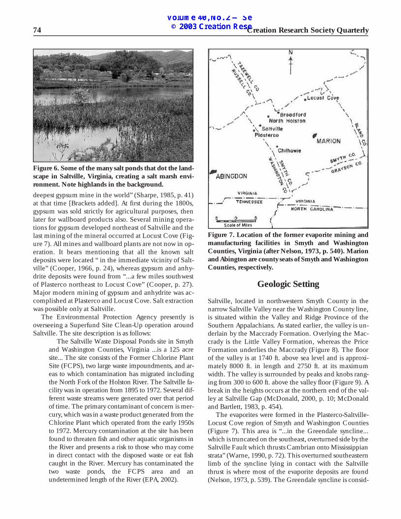
All man u fac tur ing and brine pro duc tion ceased in Salt–ville in the early 1970s. Salty ponds still dot the floor of theval ley (Fig ure 6). The move ment of salt to the sur face“...cre ated the only salt marsh hab i tat in the west ern area of Vir ginia” (Ogle, 1999, p. 2). About 20 per cent of the val ley is cov ered with stand ing wa ter (Mc Don ald, 2000, p. 10).
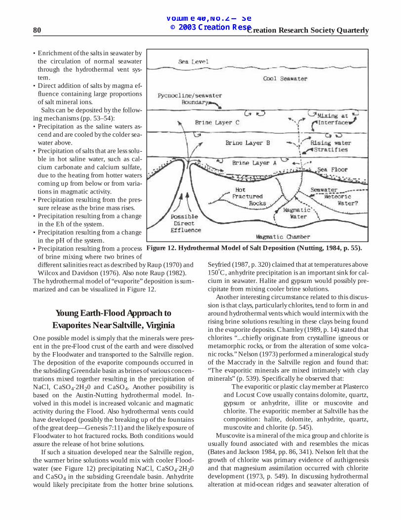
Gyp sum was found in the Maccrady and mined nearPlasterco (Fig ure 7) as early as 1815 (Coo per, 1966, p.29). The Buena Vista Plas ter Co. op er ated mines, quar -ries and a cal cin ing plant in Plasterco in the late 1800s tothe early 1900s. The United States Gyp sum Co. leasedthe Buena Vista fa cil i ties in 1909, and pur chased them in the 1920s (Sharpe, 1985, p. 41). “The No. 6 mine [atPlasterco] was op er ated from 1911 to 1979 and was the
Volume 40, September 2003 73
Fig ure 3. Rep lica of salt fur naces with ket tles in whichbrine so lu tions were evap o rated, Saltville, Vir ginia.
Fig ure 4. Rep lica of walk ing beam brine pump whichwas used to draw brine so lu tions from be low the ground, Saltville, Vir ginia.
Fig ure 5. A por tion of the for mer ae rial tram can be seenbe yond the post of fice in Saltville, Vir ginia.
Glen Wolfrom
deep est gyp sum mine in the world” (Sharpe, 1985, p. 41)at that time [Brack ets added]. At first dur ing the 1800s,gyp sum was sold strictly for ag ri cul tural pur poses, thenlater for wall board prod ucts also. Sev eral min ing op er a -tions for gyp sum de vel oped north east of Saltville and thelast min ing of the min eral oc curred at Lo cust Cove (Fig -ure 7). All mines and wall board plants are not now in op -er a tion. It bears men tion ing that all the known saltde pos its were lo cated “ in the im me di ate vi cin ity of Salt -ville” (Coo per, 1966, p. 24), whereas gyp sum and anhy -drite de pos its were found from “...a few miles south westof Plasterco north east to Lo cust Cove” (Coo per, p. 27).Ma jor mod ern min ing of gyp sum and anhydrite was ac -com plished at Plasterco and Locust Cove. Salt extractionwas possible only at Saltville.
The En vi ron men tal Pro tec tion Agency pres ently isover see ing a Superfund Site Clean-Up op er a tion aroundSaltville. The site de scrip tion is as follows:
The Saltville Waste Dis posal Ponds site in Smythand Wash ing ton Coun ties, Vir ginia ...is a 125 acresite... The site con sists of the For mer Chlo rine PlantSite (FCPS), two large waste im pound ments, and ar -eas to which con tam i na tion has mi grated in clud ingthe North Fork of the Holston River. The Saltville fa -cil ity was in op er a tion from 1895 to 1972. Sev eral dif -fer ent waste streams were gen er ated over that pe riodof time. The pri mary con tam i nant of con cern is mer -cury, which was in a waste prod uct gen er ated from the Chlo rine Plant which op er ated from the early 1950sto 1972. Mer cury con tam i na tion at the site has beenfound to threaten fish and other aquatic or gan isms inthe River and pres ents a risk to those who may comein di rect con tact with the dis posed waste or eat fishcaught in the River. Mer cury has con tam i nated thetwo waste ponds, the FCPS area and anundetermined length of the River (EPA, 2002).
Geologic Setting
Saltville, lo cated in north west ern Smyth County in thenar row Saltville Val ley near the Wash ing ton County line,is sit u ated within the Val ley and Ridge Prov ince of theSouth ern Ap pa la chians. As stated ear lier, the val ley is un -der lain by the Maccrady For ma tion. Over ly ing the Mac -crady is the Lit tle Val ley For ma tion, whereas the PriceFor ma tion un der lies the Maccrady (Fig ure 8). The floorof the val ley is at 1740 ft. above sea level and is ap prox i -mately 8000 ft. in length and 2750 ft. at its max i mumwidth. The val ley is sur rounded by peaks and knobs rang -ing from 300 to 600 ft. above the val ley floor (Fig ure 9). Abreak in the heights oc curs at the north ern end of the val -ley at Saltville Gap (Mc Don ald, 2000, p. 10; McDonaldand Bartlett, 1983, p. 454).
The evaporites were formed in the Plasterco-Saltville-Lo cust Cove re gion of Smyth and Wash ing ton Coun ties(Fig ure 7). This area is “...in the Green dale syncline...which is trun cated on the south east, over turned side by the Saltville Fault which thrusts Cam brian onto Mis sis sip pian strata” (Warne, 1990, p. 72). This over turned south east ernlimb of the syncline ly ing in con tact with the Saltvillethrust is where most of the evaporite de pos its are found(Nel son, 1973, p. 539). The Green dale syncline is con sid -
74 Creation Research Society Quarterly
Fig ure 6. Some of the many salt ponds that dot the land -scape in Saltville, Vir ginia, cre at ing a salt marsh en vi -ron ment. Note high lands in the back ground.
Fig ure 7. Lo ca tion of the for mer evaporite min ing andman u fac tur ing fa cil i ties in Smyth and Wash ing tonCoun ties, Vir ginia (af ter Nel son, 1973, p. 540). Marionand Abington are county seats of Smyth and Wash ing ton Coun ties, re spec tively.
Glen Wolfrom

ered im por tant be cause it con tains the youn gest for ma -tions, the Mis sis sip pian strata (ac cord ing to the geo logictime ta ble),"...oc cur ring in the mid dle of the Val ley be -tween the Blue Ridge and Ap pa la chian Plateaus" (Butts,1973, p. 457).
The Saltville Fault has a strike length of 430 miles fromnorth ern Al a bama to south west ern Vir ginia (House andGray, 1982, p. 833) and strati graphic dis place ment of over16,000 feet (Sharpe, 1985, p. 43). It is con sid ered “...thebest ex am ple of large-scale footwall folds at the end of ama jor Ap pa la chian thrust...” along its trace in south west -ern Vir ginia (Milici, 1970, p. 136). It is con jec tured thatthe fold ing de vel oped prior to thrust ing as Brent (1985, p.82) noted that large syn clines were com pletely formed insouth west Vir ginia be fore north west mov ing thrustsreached the south east ern flanks of the synclines.
Various Proposals onHow the Evaporites Formed
The first re corded ac count con cern ing the or i gin of theevaporite de pos its in the Saltville re gion ap pears to havebeen given by W.B. Rog ers (1836 re printed in 1884). Hesug gested that since the py rite-con tain ing shale is foundin frag ments mixed with gyp sum and clay of the saltwells, the iron py rite (FeS2) was ox i dized pro duc ing sul -fu ric acid which re acted with the sur round ing lime stonepro duc ing cal cium sul fate. Rec og niz ing that salt de pos its oc cur along with gyp sum de pos its, Stevenson (1885) ad -vanced a sim i lar pro posal con cern ing the or i gin of thegyp sum de pos its. The inpouring of wa ter from sul fursprings into a lit to ral lake in the deep Saltville ba sin re -acted with dis solved calcium carbonate in solution,forming gypsum deposits.
Eckel (1903) of fered a model of de po si tion of the inter -bedded salt and gyp sum de pos its by the mech a nism ofevap o ra tion of sea wa ter in a par tially or en tirely en closed
ba sin. Stose (1913, p. 73) con cluded that the gyp sum andsalt minerals were:
...de rived from cal car e ous-ar gil la ceous sed i mentswhich orig i nally con tained dis sem i nated gyp sumand salt pre cip i tated in a par tially inclosed [sic] armof the sea dur ing the de po si tion of the Maccrady for -ma tion, these min er als hav ing been con cen trated inthe same for ma tion by ground wa ters which cir cu -lated along the fault con tact... dis solved the cal ciumcar bon ate from the earthy lime stones, and seg re -gated the gyp sum and salt in gypsiferous and salinebeds by chemical selection.
Withington (1965), ob serv ing that “...lam i nated gyp -sum, typ i cal of bed ded gyp sum de pos its...”(p. 39) hadbeen found in the iso lated gyp sum blocks mined thus far.He as sumed that the salt and cal cium sul fate (likely in theform of anhydrite) were laid down as a por tion of the orig i -nal depositional se quence. The Maccrady near Plastercoand Saltville orig i nally may have con tained bed ded cal -cium sul fate, salt, shale and thin sand stone in an ap prox i -mately 100 feet thick unit. “The Maccrady acted as alu bri cated mass over which the thrust plate glided” (p.40).Dur ing the thrust ing pro cess, the over rid ing mat ter ex -
Volume 40, September 2003 75
Fig ure 8. A geo logic cross sec tion of the evaporite de pos its be tween Plasterco and Saltville (af ter Withington, 1965, p.38).
Fig ure 9. High lands above Saltville Val ley look ing south from the town of Saltville.
Glen Wolfrom

truded the Maccrady in front of it which con cen trated theCaSO4 and salt by plas tic flow, thick en ing the for ma tion.Si mul ta neously, lime stones and other im pu ri ties were in -tro duced into the evaporites by the force of the thrust ingpro cess. Frag ments of the Lit tle Val ley Lime stone and pos -si bly the un der ly ing Price were moved with and into “...the jum bled mass of the Maccrady” (p. 40). Bed ded gyp sumfound at the Plasterco mine (in the up per Maccrady) wasnot dis turbed very much by the thrust ing pro cess as thema jor move ment “...took place east and south east of Plas -terco” (p. 40). Fig ure 8 is a cross sec tion of the evaporitede pos its in relation to his model of how the beds formed inthe Saltville-Plasterco area.
By ron Coo per (1966, p. 14) ob served that:The Maccrady For ma tion in the Plasterco-Salt -
ville-Broad ford-Lo cust Cove belt of out crop showssome of the most re mark able lo cal strati graphic vari a -tions of any for ma tion in the south ern Ap pa la chians.
Coo per (pp. 11, 29) stated that the Green dale synclinewas a depositional syncline where evaporites which in cludeha lite, mi nor blue salt, anhydrite, gyp sum and do lo mite oc -cur mainly in the Maccrady plas tic shale mem ber. All ofthese ma te ri als orig i nally formed as broad lenses or beds butwere sub jected to shear ing, fold ing and cataclasis caus ingcon sid er able dis rup tive flow and re dis tri bu tion in the up perlimb of the syncline. Salt in this limb is mainly found as tec -tonic brec cia (cataclasts). The pres ence of salt brec cias in the limb does not im ply that all of the Saltville salt is tec tonic. Inthe up right lower limb of the syncline, well cut tings from the high pres sure brine fields have shown that some of the salt“...could be from indigenous salt beds” (p. 27).
As for gyp sum and anhydrite in the mine at Plasterco,the min er als are pres ent to gether as “...large lenslike topod-shaped...” bod ies in such a re la tion ship “that the an -hy drite was def i nitely ear lier than the gyp sum.” The gyp -sum from the mines at North Holston was in bed dedde pos its and was com pletely hy drated “...but mixed withanhydrite down dip” (p. 28). The gyp sum at Lo cust Coveis also bed ded but com pletely hy drated (Coo per, 1966, p.28). Later, Nel son (1973, p. 545) noted the pres ence ofsmall amounts of anhydrite in some of the deep est gyp sumlayers at Locust Cove.
Coo per claimed that the en vi ron men tal con di tionsnec es sary for a do lo mite-anhydrite-ha lite depositional se -quence are “...evap o ra tion of ma rine wa ters in a stilled ba -sin re plen ished from time to time by sea wa ter" (p. 29).This evap o ra tion prob a bly oc curred over at least 2000square miles to have enough sea wa ter to form the anhy -drite found in the region.
The spe cial depositional con di tions that musthave ex isted in the Saltville dis trict are note wor thy.Whereas the Maccrady on the north west flank of theGreen dale syncline is gen er ally only about 165 feetthick at most... the thick nesses of plas tic shale andevaporites in the up per Maccrady of the south eastlimb, range up to 1,700 feet, sig ni fies pro found dif -fer en tial sub si dence in the ax ial por tion of theGreen dale syncline and its north east ward ex ten sion,the Lo cust Cove syncline (p. 29).
A geo logic sec tion (Fig ure 10) of Saltville Val ley il lus trates the above ob ser va tion. Coo per con sid ered that this dif fer -en tial downwarping dur ing the lo cal Maccrady de po si tion
76 Creation Research Society Quarterly
Fig ure 10. Geo logic cross sec tion show ing the Green dale Syncline and the Saltville Thrust Fault trace in Saltville Val -ley re gion (af ter Mc Don ald, 2000, p. 11).
Glen Wolfrom

was an “embryotectonic fore run ner” of the syncline. Thusthe synclinal folds were de vel op ing dur ing the Maccradydepositional pro cess. “Nu mer ous rep e ti tions of anhydriteand do lo mite in the red, green and gray shales sug gest cy -cli cal con di tions of evaporite for ma tion... Over turn ing ofthe south east limb of the fold..." (p. 30) caused anhydritebod ies to elon gate into pods. The de pos ited anhydrite was“...hy drated wholly or par tially to gyp sum” (p. 30). Coo -per’s in ter pre ta tion of the ge ol ogy of the Saltville-Plasterco area is shown in Figure 11.
The fact that ...gyp sum bod ies and salt bod ies arenot known to oc cur to gether in the Vir ginia de pos itsmay im ply that the hydration of the anhydrite anddis so lu tion of salt went on si mul ta neously (p. 28).
Coo per (p. 15) con jec tured that Lo cust Cove and theSaltville- Plasterco lo ca tions prob a bly were part of themain evap o rat ing ba sin and pos si bly the Lo cust Cove de -posit could have formed in a sep a rate ba sin “...in which nosalt and only anhydrite and pos si bly some do lo mite werede pos ited by the evap o rat ing waters” (p. 15).
Sharpe (1985, p. 44) stated that “The Maccrady For ma -tion was de pos ited in a mud-rich sabkha en vi ron ment.”
Gyp sum and anhydrite were de pos ited as dia -genetic min er als within the tidal flat sed i ments...Ground wa ter moves by cap il lary ac tion through thesed i ments above the wa ter ta ble. Re charge oc curs bylat eral move ment of sea wa ter through the tidal flatwedge and pe ri odic storm flood ing (Sharpe, p. 45).
Volume 40, September 2003 77
Fig ure 11. Geo logic map of the Saltville-Palsterco re gion (from Coo per, 1966, p. 13).
Glen Wolfrom

Gyp sum and anhydrite were sub jected to al ter ation andde for ma tion af ter de po si tion form ing the “boul der zone.”Lenslike masses of an hy dride and gyp sum “...were de -formed, folded and thick ened by plas tic flow...” when theGreen dale and Lo cust Cove syn clines were formed andthe Saltville thrust was ac tive (Sharpe, p. 46).
A thick bed of gyp sum known as the “footwallseam” oc curs at the top of the Maccrady For ma tionin the No. 6 mine (Sharpe, p. 46).
The seam was up to 50 feet thick and was mined to a depthof 1420 feet where it graded into anhydrite. Sharpe (p. 46)con sid ered that the seam was a shal low subtidal de posit.The seam was not pres ent at the Lo cust Cove Mine.
Warne (1990, p. iii) con jec tured that the thick salt andgyp sum de pos its in the Saltville re gion were the re sult oflo cal syndepositional sub si dence, a change from hu mid toarid cli mate as the North Amer i can Plate drifted north -ward and an eustatic sea-level rise. These evaporite de pos -its could have been thick ened and con cen trated intobou dins by move ment of the Saltville thrust fault withthixotropic clays act ing as prin ci pal lubricants (p. 90).
Ver ti cal tec tonic move ment could have hin dered ma -rine wa ter move ment out of the sub sid ing ba sin whichwould have in creased brine res i dence time so that the wa -ters be came sat u rated with ha lite and anhydrite. The rap -idly sub sid ing Green dale ba sin acted as a deep wa terma rine sa lina at first where bed ded gyp sum, anhydrite andha lite were de pos ited. The ba sin was quickly filled and lev -eled by de po si tion with pri mar ily ha lite in the deep estparts of the ba sin. Sabkha and mud flat de pos its ofevaporites then be came the pri mary mode of pre cip i ta -tion. Siliciclastics flowed into the ba sin dur ing mi nor sea-level fluc tu a tions which re sulted in interbedded shalesand evaporites in the Maccrady (pp. 140–149).
Some Problems with EvaporiteDeposition Models
Many geo logic mod els for the de po si tion of evaporites in -clude the as sump tion of arid or semi-arid cli mate con sid -ered nec es sary to evap o rate sea wa ter. Krumbein (1951)cat a loged the var i ous evaporite de pos its in the UnitedStates ac cord ing to their po si tion in the geo logic col umn.Us ing the geo logic time ta ble, he noted “...that evaporitesoc cur in rocks of ev ery sys tem from Or do vi cian throughTer tiary” (p. 63). Later in the article he stated that:
...there seems no need for call ing upon “gen eral arid -ity” dur ing a geo logic pe riod to ac count for its eva -porites. Rather, the im pli ca tion for his tor i cal ge ol ogy is that tectono-en vi ron men tal con di tions for eva po -rites were of com mon oc cur rence, and that the eva -porites fit into the cli ma tic pic ture of any pe riod asnor mally expected phenomena (p. 80).
Thus, arid or semi-arid con di tions may not be nec es sary toform evaporites. The mod ern geo logic mod els that re quire arid ity to cause evap o ra tion in clude sabkhas, mar ginal saltpans, rel ict seas, desert lakes, mud flats, salt flats, barredbas ins and la goons to name a few. To day, sabkhas are more fre quently sug gested as a mech a nism for cer tain evaporitede pos its that formed in the past. Kend all (1979a, p. 145)observed:
The dogma of the de cade—supratidal (sabkha)evaporites—has be come much too one-sided be -cause there are other evaporite types that clearly areof sub aque ous or i gin. It is prob a bly true that, giventhe cor rect en vi ron men tal con di tions, evaporites can mimic most other sed i ment types.
A sam pling of evaporite for ma tion mod els can be found inthe Ap pen dix. There is no doubt that mi nor evaporite deposits can pres ently form in small amounts by the mech -a nisms noted pre vi ously. It ap pears un likely that the mas -sive evaporite de pos its in the geo logic re cord are the re sultof such mech a nisms. For in stance, con sider the re marks of Aus tin and Humphreys (1990, p. 22) on halite deposition:
Many have as sumed that the ma jor path way forNa+ re moval from to day’s ocean is the de po si tion ofthe min eral ha lite. How ever, the ma jor ha lite de pos -its ac cu mu late cur rently from con cen trated river wa -ter on the con ti nents, not from the ocean. Mod ernma rine sed i men tary de pos its are nearly de void of ha -lite. Re cent ma rine salt flats and coastal la goons occur along the Per sian Gulf, along the Gulf of Cal i -for nia, and on the west coast of Aus tra lia, but theyhave very mea ger de pos its of ha lite. When ha lite isde pos ited in ma rine salt flats and coastal la goons,fresh en ing of the brine after deposition oftenredissolves the halite.
The above ob ser va tions sup port what Smith, Fried manand McLaughlin (1987, p. 826) claimed con cern ing saltde po si tion in a mod ern des ic cat ing saline lake:
The ini tial pur pose of our study was to un der stand better how “pri mary” crys tal li za tion pro cesses in ades ic cat ing sa line lake carry an im print in the spe cies and iso to pic con tent of the hy drated min er als thatcan be trans lated into a paleoclimatic re cord... It isper haps ironic that what we have de ter mined is thatin salt bod ies hav ing this bulk com po si tion, and crys -tal lized in an area with marked sea sons, there is nosuch re cord, be cause the “pri mary” hy drated-min -eral as sem blages never sur vive more than a fewmonths. In de ter min ing this, how ever, we de vel oped a ba sis for pre dict ing that the re cord that will sur viveis the min eral as sem blage ex ist ing af ter post-depo -sitional diagenesis has ceased. This will hap pen onlyaf ter a sa line layer is bur ied to depths where sea sonalchanges cease and near-mean an nual tem per a turesfor the area pre vail, and this is prob a bly a more use ful
78 Creation Research Society Quarterly
Glen Wolfrom

component of paleoclimatic data than the one we set out to determine.
Pres er va tion of “evaporites” may have de pended uponrapid burial at depth to avoid res o lu tion. An other con trol -ling fac tor may have been the for ma tion of evaporites ingreat depths of wa ter un der con di tions not op er at ing pres -ently. Kend all (1979a, p. 145) noted that “...Ar eas of pres -ent day evaporite de po si tion com pa ra ble in size withthose of the past are ab sent.” Con tin u ing in this di rec -tion, Whit comb and Mor ris (1963, p. 412) stated thatpres ent rates of evap o ra tion are too slow to de velop hugesalt de pos its which later tec tonic ac tiv ity formed intodomes. Of ten domes have di am e ters of 1000 feet to twomiles and ex tend down ward sev eral thou sand feet. Evap -o ra tion of stand ing wa ter would re quire a col umn of sea -wa ter 8000 feet deep to produce a 100 feet-deep depositof salt (p. 413).
Nevins (1974, p. 243), in dis cuss ing the Castile eva -porite beds of west Texas and south east New Mex ico, ex -plained that the ra tio of CaSO4 and NaCl in these beds isnot in agree ment with the ra tio of the two com pounds thatwould be ex pected from the evap o ra tion of nor mal sea wa -ter. Nel son (1973, pp. 546, 547), in de scrib ing the salt de -pos its of Saltville noted:
The com po si tion of brines ob tained by dis so lu -tion of the salt de pos its at Saltville is no ta bly de fi -cient in mag ne sium..., and nei ther mag ne sium norpo tas sium bear ing salts have been found. The pro -por tions of car bon ate, sul fate, and chlo ride in thesec tion do not con form with those ex pected by pro -gres sive evap o ra tion of sea wa ter... In com mon withmany salt de pos its, the pro por tion of sul fates is toohigh com pared to chlo ride. In stead, the ba sin musthave been a rel a tively small one con nected to theopen sea in such a man ner that the re sid ual brinescould be fresh ened after halite and anhydrite beganprecipitating.
Are evaporites prop erly la beled? Whitcomb and Mor ris(1963) stated “Mod ern writ ers are grad u ally com ing to theopin ion that even the strat i fied evaporite beds are verylargely the re sult of meta mor phic pro cesses rather thansim ple sed i men ta tion and evap o ra tion” (p. 416). Kend all(1979a) commented:
Lastly but most im por tantly, evaporites are mostsus cep ti ble to ex ten sive post-depositional change.The sol u bil ity of evaporite min er als, the ten dencyfor metastable hy drates to be pre cip i tated, and thesus cep ti bil ity of salts to flowage un der burial con di -tions are fea tures unique to evaporites and have thecom mon re sult of oblit er at ing orig i nal sed i men tarychar ac ter is tics dur ing diagenesis. The pro found ef -fects of these changes means that some evaporites are better con sid ered meta mor phic rocks than sedi -ments (p. 145).
Creationist Models of Evaporite Formation
Whitcomb and Mor ris (1963) spec u lated it was pos si blethat an evaporite bed merely had been trans ported byFloodwater “...from some pre vi ous lo ca tion where it mayhave ex isted since the Cre ation” (p. 412). They sug gestedthat a tec tonic mech a nism, rather than evap o ra tion, maybe more fea si ble to ex plain evaporite de pos its (p. 414). An -other sug ges tion they of fered was the pos si bil ity of sub -aque ous vol ca nic ac tiv ity dur ing the Flood that wouldde velop lo cal ized high tem per a ture con di tions whichcould cause the pro duc tion of evaporite com pounds (p.417). Froede (2000) re in forced the con cept of large-scalesub ma rine vol ca nism oc cur ring in the Flood event. Thuslo cal ized el e vated tem per a tures nec es sary for hy dro ther -mal formation of evaporites could have existed throughout the Deluge.
Nevins (1974, p. 243) noted that evaporites have beenfound at depths of 10,000 feet be low sea level at three lo ca -tions; in the At lan tic Ocean, on the mar gin of the con ti -nent of south west Af rica and in the Med i ter ra nean Sea.Such de pos its could not be the re sult of evap o ra tion andhe quoted Sozansky (1973) who sug gested “...the emer -gence of hot brines from great depths dur ing tec tonicmove ments...” could have caused the pre cip i ta tion of eva -porites. Nevins then dis cussed the brine mix ing ex per i -ments of O. B. Raup (1970, pp. 2246–2259) with the rapidpre cip i ta tion of salt. The mix ing of cer tain con cen tra tionsof brine so lu tions caused salt to pre cip i tate in min utes.Gyp sum can be pre cip i tated rap idly by a sim i lar mech a n -ism (Raup, 1982, pp. 363–367). Nevins pro posed a vol ca -nic or i gin of brines dur ing the Flood when the foun tains of the great deep were re leased by tec tonic forces (p. 243). Ina Cre ation Re search So ci ety study on brine mix ing, Wil -cox and Davidson (1976, pp. 87–89) ob tained re sults thatin di cated less rig or ous con di tions than those used by Raupstill might achieve the pre cip i ta tion of so dium chlo ride.Steve Aus tin (1984, pp. 120–121, 130–133, 223–224) ab -stracted sev eral stud ies on evaporites as well as salt dia pir -ism that per tain to the pos si bil ity of dif fer ent mech a nismsof de po si tion rather than evap o ra tion. Da vid Nutting, un -der the guid ance of Aus tin, de tailed a hy dro ther mal model for the for ma tion of bed ded salt de pos its. For a brief syn op -sis of this trea tise, see Williams (1989). The modelrequires the following circumstances (Nutting, 1984, p.52) in order to be viable:• A pe riod of in tense un der sea vol ca nic or ig ne ous in tru -
sive ac tiv ity.• Wide spread hy dro ther mal vent sys tems through which
much wa ter cir cu lates.• A ba sin for de po si tion of no spe cific wa ter depth al -
though large de pos its re quire large basins.Salts avail able for de po si tion are formed by a com bi na -
tion of two mech a nisms (pp. 52–53):
Volume 40, September 2003 79
Glen Wolfrom
• En rich ment of the salts in sea wa ter by the cir cu la tion of nor mal sea wa terthrough the hy dro ther mal vent sys -tem.
• Di rect ad di tion of salts by magma ef -flu ence con tain ing large pro por tionsof salt min eral ions.Salts can be de pos ited by the fol low -
ing mech a nisms (pp. 53–54):• Pre cip i ta tion as the sa line wa ters as -
cend and are cooled by the colder sea -wa ter above.
• Pre cip i ta tion of salts that are less sol u -ble in hot sa line wa ter, such as cal -cium car bon ate and cal cium sul fate,due to the heat ing from hot ter wa terscom ing up from be low or from vari a -tions in magmatic activity.
• Pre cip i ta tion re sult ing from the pres -sure re lease as the brine mass rises.
• Pre cip i ta tion re sult ing from a changein the Eh of the sys tem.
• Pre cip i ta tion re sult ing from a changein the pH of the sys tem.
• Pre cip i ta tion re sult ing from a pro cessof brine mix ing where two brines ofdif fer ent sa lini ties re act as de scribed by Raup (1970) andWilcox and Davidson (1976). Also note Raup (1982).
The hy dro ther mal model of “evaporite” de po si tion is sum -ma rized and can be vi su al ized in Fig ure 12.
Young Earth-Flood Approach toEvaporites Near Saltville, Virginia
One pos si ble model is sim ply that the min er als were pres -ent in the pre-Flood crust of the earth and were dis solvedby the Floodwater and trans ported to the Saltville re gion.The de po si tion of the evaporite com pounds oc curred inthe sub sid ing Green dale ba sin as brines of var i ous con cen -tra tions mixed to gether re sult ing in the pre cip i ta tion ofNaCl, CaSO4×2H20 and CaSO4. An other pos si bil ity isbased on the Aus tin-Nutting hy dro ther mal model. In -volved in this model is in creased vol ca nic and mag maticac tiv ity dur ing the Flood. Also hy dro ther mal vents couldhave de vel oped (pos si bly the break ing up of the foun tainsof the great deep—Gen e sis 7:11) and the likely ex po sure of Flood water to hot frac tured rocks. Both con di tions wouldassure the release of hot brine solutions.
If such a sit u a tion de vel oped near the Saltville re gion,the warmer brine so lu tions would mix with cooler Flood -water (see Fig ure 12) pre cip i tat ing NaCl, CaSO4×2H20and CaSO4 in the sub sid ing Green dale ba sin. Anhydritewould likely pre cip i tate from the hot ter brine so lu tions.
Seyfried (1987, p. 320) claimed that at tem per a tures above 150ºC, anhydrite pre cip i ta tion is an im por tant sink for cal -cium in sea wa ter. Ha lite and gyp sum would pos si bly pre -cip i tate from mixing cooler brine solutions.
An other in ter est ing cir cum stance re lated to this dis cus -sion is that clays, par tic u larly chlorites, tend to form in andaround hy dro ther mal vents which would in ter mix with the ris ing brine so lu tions re sult ing in these clays be ing foundin the evaporite de pos its. Chamley (1989, p. 14) stated that chlorites “...chiefly orig i nate from crys tal line ig ne ous ormeta mor phic rocks, or from the al ter ation of some vol ca -nic rocks.” Nel son (1973) per formed a min er al og i cal study of the Maccrady in the Saltville re gion and found that:“The evaporitic min er als are mixed in ti mately with claymin er als” (p. 539). Specifically he observed that:
The evaporitic or plas tic clay mem ber at Plasterco and Lo cust Cove usu ally con tains do lo mite, quartz,gyp sum or anhydrite, illite or mus co vite andchlorite. The evaporitic mem ber at Saltville has thecom po si tion: ha lite, do lo mite, anhydrite, quartz,mus co vite and chlorite (p. 545).
Mus co vite is a min eral of the mica group and chlorite is usu ally found as so ci ated with and re sem bles the micas(Bates and Jack son 1984, pp. 86, 341). Nel son felt that thegrowth of chlorite was pri mary ev i dence of authigenesisand that mag ne sium as sim i la tion oc curred with chloritede vel op ment (1973, p. 549). In dis cuss ing hy dro ther malal ter ation at mid-ocean ridges and sea wa ter al ter ation of
80 Creation Research Society Quarterly
Fig ure 12. Hy dro ther mal Model of Salt De po si tion (Nutting, 1984, p. 55).
Glen Wolfrom

ba salt, Seyfried (1987, p. 319) stated that chlorites andsmectites form dur ing ex per i ments on the sea wa ter al ter -ation of ba salt at 150–350ºC (mag ne sium is re moved fromsea wa ter dur ing the re ac tion). Also SiO2 is in volved in thepro duc tion of these clay par ti cles and any unreacted SiO2(quartz) would likely mix with the clays.
Nel son dif fer en ti ated be tween two va ri et ies of chloritespres ent in the evaporites—a de tri tal va ri ety (that pos si blycould have come from ar gil la ceous sed i ments around theevaporitic ma te rial dur ing tec tonic move ment?) and anauthigenic finely crys tal line va ri ety (formed with the eva -porites?). The de tri tal va ri ety broke down into a fri a ble orfrag mented soil when ex posed to weath er ing (ex po sure towa ter) as is typ i cal of most Ap pa la chian clays (p. 554). Theauthigenic “...red and green clays from the evaporitic fa -cies flake and flocculate when in con tact with wa ter,...weath er ing pro duces a wet, co he sive and plas tic claymass...” (p. 554). Thus dur ing weath er ing, the authigenicchlor ites trans form into an ex pand ing clay, smectite(p.554). Chamley (1989, p. 422) noted:
The min er als most fre quently en coun tered in hy -dro ther mal vents and wall-rocks are magnesian spe -cies such as chlorite, talc, ser pen tine, fi brous clays,corrensite, Mg-smectite and nu mer ous non-claymin erals.
Re port ing on an other in ves ti ga tion (p. 379) Chamleyob served, “In the Douala ba sin, Cam er oon, chlorite is sup -posed to re sult from the down ward trans for ma tion of smec -tite in a magnesian en vi ron ment.” He also noted that,“With in creas ing depth both smectite-bentonites and kao -lin ite-bentonites tend to be re placed by typ i cal late-diagenetic clays such as illite-smectite, illite and evenchlorite” (p. 413). Pos si bly the orig i nal clay formed in a hy -dro ther mal or mag matic en vi ron ment was a smectitewhich was trans formed into a chlorite (by the magnesianen vi ron ment and deep burial). Then the chlorite laterweath ered back into smectite? Or pos si bly the plas tic claysare swell ing chlorites or pseudo-chlorites which ex pandlike smectites in wa ter but re sist heat ing like chlorites.“They ap pear to rep re sent an al ter na tion of smectite lay ersand octahedral brucitic sheets” (Chamley, 1989, p. 15).
In any case, the pres ence of chlorite and its diageneticprod uct, smectite, speaks of a hy dro ther mal or mag maticor i gin for the clays in ti mately mixed with the evaporites,sup port ing the hy dro ther mal model of Aus tin andNutting. As a mat ter of fact, Hayden made the fol low ingre mark in 1843 about the Saltville deposits:
The lo cal oc cur rence of a fault, the gen er ally dis -turbed con di tion of the rocks, and the an hy drous nature of the salt, all ar gue the ac tion of heat con tem -po ra ne ously with, or sub se quently to the de po si tionof the salt (pp. 175, 176).
Thus, I pre fer the hy dro ther mal model for the or i gin of the evaporite de pos its in the Saltville re gion.
Af ter de po si tion, the tec tonic ac tion on the evaporitesshould be con sid ered. The lack of strength of the evaporite beds con tain ing clays and shales would act as a zone ofweak ness ren der ing the mass sus cep ti ble to move ment ifsub jected to tec tonic forces. Ad ja cent re cently sub -aqueously-de pos ited lime stones, dolostones, sand stones,etc. likely would be semi-rigid and more com pe tent. AsFloodwater be gan to re cede, the crust of the earth wouldbe sub jected to fold ing, fault ing and up lift as the height ofthe wa ter above the crust was re duced. A new crustal equi -lib rium would be es tab lished with de creas ing wa ter pres -sure dur ing the pe riod of wa ter re ces sion from thecon ti nent. Fault ing and crustal ad just ment likely wouldcause move ment of the evaporitic lay ers, squeez ing themup ward and out ward in the Saltville re gion. Pos si bly theevaporites would be thinned and pinched out north east -ward be yond Lo cust Cove and south west ward be yondPlas terco. The move ment of the Saltville Fault mightcause frag men ta tion of strata ad ja cent to the shift ingevaporite beds. Many of the frag ments would be car riedalong with the Maccrady and if some of the de tri tus was ar -gil la ceous, more clay (detrital variety?) would be forcedinto the evaporitic mass.
Cataclasis would de velop as the mov ing salts likelywould in ter mix form ing “boul ders,” “pods,” or “boudins”par tic u larly in up per lay ers of the evaporitic mass. Thedeeper de pos its of evaporites may have re mained rel a tively un af fected by the tec tonic forces. If af ter up lift the de pos its were ex posed to re ced ing Floodwater cur rents, con sid er -able ero sion and so lu tion of the min er als could take place,scour ing the Maccrady far ther down ward un til all that re -mained near the pres ent lo ca tion of Saltville was a salty,swampy area or a sa line lake in the val ley as the sed i mentsin the heights around the val ley dried and hard ened. Even -tu ally the sed i men tary lay ers around and be low the Mac -crady would harden, sta bi liz ing the strata as tectonicmovement lessened and then ceased.
The mod els of fered are con sid ered ten ta tive and morestudy is nec es sary to re in force or re ject these ideas. Thereare likely other evaporite de pos its that would lead an in ves -ti ga tor to en tirely dif fer ent con clu sions. The tectonismthat oc curred would de stroy or dis turb most of the orig i nalbed ding of the evaporites, mak ing any in ves ti ga tion a diffi -cult undertaking.
Glossary
ar gil la ceous: con tain ing clayauthigenic: formed in place boudin: sau sage-shaped seg ment brucite: hex ag o nal min eral, Mg(OH)2cataclasis: rock de for ma tion by frac ture, crush ing or gran -
u la tion
Volume 40, September 2003 81
Glen Wolfrom

chlorite: a group of platy usu ally green ish clay min er als.Chlorites are as so ci ated with and re sem ble micas.
corrensite: clay min eral with a struc ture that rep re sents the interstratification of chlorite and ver mic u lite struc turesor of chlorite and smectite struc tures
diapirism: pierc ing or rup tur ing of domed or up lifted rocks by mo bile core ma te rial
eustatic: per tain ing to world wide changes of sea-levelevaporites: sed i men tary salts pre cip i tated from aque ous so -
lu tion and con cen trated by evap o ra tionillite: gen eral name for a group of three-layer, mica-like
clay min er alslit to ral: per tain ing to the ben thic en vi ron ment or depth
zone be tween high and low watermag matic: per tain ing to or de rived from magma mus co vite: a min eral of the mica grouppycnocline: a den sity gra di ent; a layer of wa ter in the
ocean char ac ter ized by a rapid change of den sity withdepth
sabkha: a supratidal en vi ron ment of sed i men ta tion formed un der arid to semiarid con di tions on re stricted coastalplains just above nor mal high tide
sa lina: a body of sa line wa ter such as a salt pond, spring orplaya lake
salt pan: a small shal low de pres sion where wa ter ac cu mu -lates and evap o rates leav ing a salt deposit
ser pen tine: a group of rock-form ing min er als with the for -mula (Mg,Fe)3Si205(OH)4
smectite: a group of ex pand ing-lat tice clay min er alstalc: soft, green or gray min eral, Mg3Si4O10(OH)2thixotrophic: change from a gel to a sol when dis turbed, a
prop erty of colloids such as bentonitic clay
Acknowledgments
The gra cious help of the per son nel of the Saltville Pub licLi brary is def i nitely ap pre ci ated. All of the peo ple withwhom I talked in Smyth County about var i ous sub jectscon cern ing the evaporite de pos its, min ing and man u fac -tur ing lo ca tions, etc. were most kind and help ful. CarlFroede, Jr. pre pared the graphics for the fig ures and pro -vided some use ful in for ma tion. Jerry Akridge also aided inthe lit er a ture search. I am in debted to Carl, Jerry and JohnReed for their en cour age ment and sug ges tions to im provethe manu script. I thank the many do nors to the Cre ationRe search So ci ety Re search Fund, in ter est from whichfinanced a portion of these studies.
Appendix
In ter ested read ers may con sult the fol low ing ref er ences for var i ous uniformitarian mod els of evaporite de po si tion:
Dean, Davies and An der son, 1975, pp. 367–372; Ev ans,1970, pp. 1349–1352; Fried man, 1972, pp. 1072–1086;Hardie, 1984, pp. 193–240; Kend all, 1979a, pp. 145–157;1979b, pp. 159–174; Kins man, 1969, pp. 830–840; 1974,pp. 343–348; Pres ley, 1987, pp. 167–190; War ren andKend all, 1985, pp. 1013–1023.
References
CRSQ: Cre ation Re search So ci ety Quar terlyAus tin, S. A. 1984. Ca tas tro phes in earth his tory. ICR
Tech ni cal Mono graph 13. In sti tute for Cre ation Re -search, El Cajon, CA.
Aus tin, S. A. and D. R. Humphreys. 1990. The sea’s miss ingsalt: a di lemma for evo lu tion ists in Walsh, R. E. and C.L. Brooks (ed i tors). Pro ceed ings of the sec ond in ter na -tional con fer ence on creationism July 30–Au gust 4. Vol -ume II—Tech ni cal sym po sium ses sions and ad di tionaltop ics, pp. 17–33. Cre ation Sci ence Fellowship, Pitts -burgh.
Bates, R. L. and J. A. Jack son. 1984. Dic tio nary of geo log i -cal terms (third edi tion) An chor Books, New York.
Brent, W. B. 1985. Rel a tive age of large folds and ma jorthrusts in the Val ley and Ridge of north east ern Ten nes -see and ad ja cent Vir ginia. Geo log i cal So ci ety of Amer icaSouth east ern Sec tion Ab stracts with Pro grams 17(2):82.
Butts, C. 1973. Ge ol ogy of the Ap pa la chian Val ley in Vir -ginia, Part 1: Geo logic text and il lus tra tions. Vir giniaGeo log i cal Sur vey Bul le tin 52 re print. Charlottesville.
Chamley, H. 1989. Clay sedimentology. Springer-Verlag,New York.
Coo per, B. N. 1966. Ge ol ogy of the salt and gyp sum de -pos its in the Saltville area, Smyth and Wash ing tonCoun ties, Vir ginia in Rau, J. L. (ed i tor). Sec ond sym po -sium on salt, Vol ume 1: Ge ol ogy, geo chem is try and min -ing, pp. 11–34. North ern Ohio Geo log i cal Society,Cleveland.
Craig, J. R. 1973. Geo logic eval u a tion of the Saltville area,Smyth County Vir ginia. Saltville Plan ning Com mis sion.
Dean, W. E., G. R. Davies and R. Y. An der son. 1975.Sedimentological sig nif i cance of nod u lar and lam i -nated anhydrite. Ge ol ogy 3:367–372.
Eckel, E. C. 1903. United States Geo log i cal Sur vey Bul le -tin 213 as quoted in Stose, G. W. 1913.
EPA. 2002. Saltville waste dis posal ponds, cur rent site in for -ma tion. http://www.epa.gov/reg3hwmd/super/VA/saltville-waste/pad.htm.
Ev ans, R. 1970. Sed i men ta tion of the Mis sis sip pian evapo -rites of the Maritimes: An al ter nate model. Ca na dianJour nal of Earth Sci ences 7:1349–1352.
Fried man, G. M. 1972. Sig nif i cance of Red Sea in prob -lem of evaporites and basinal lime stone. Amer i can As so -ci a tion of Pe tro leum Ge ol o gists Bul le tin 56:1072–1086.
82 Creation Research Society Quarterly
Glen Wolfrom

Froede, Jr., C. R. 2000. Sub ma rine vol ca nism: Part I—Sub aque ous ba salt erup tions and lava flows CRSQ 37:22–35.
Hardie, L. A. 1984. Evaporites: Ma rine or non-ma rine?Amer i can Jour nal of Sci ence 284:193–240.
Hayden, C. B. 1843. On the rock salt and sa lines ofHolston. Amer i can Jour nal of Sci ence and Arts 44:173–179.
House, W. M. and D. R. Gray. 1982. Dis place ment trans -fer at thrust ter mi na tions in South ern Ap pa la chians-Saltville thrust as ex am ple. Amer i can As so ci a tion of Pe -tro leum Ge ol o gists Bul le tin 66:830–842.
Kend all, A. C. 1979a. Con ti nen tal and supratidal (sabkha) evaporites in Walker, R. G. (ed i tor). Fa cies mod els, pp.145–157. Geoscience re print se ries 1. To ronto.
Kend all, A. C. 1979b. Sub aque ous evaporites in Walker,R. G. (ed i tor). Fa cies mod els, pp. 159–174. Geosciencere print se ries 1. To ronto.
Kins man, D. J. J. 1969. Modes of for ma tion, sed i men taryas so ci a tions, and di ag nos tic fea tures of shal low wa terand supratidal evaporites. Amer i can As so ci a tion of Pe -tro leum Ge ol o gists Bul le tin 53:830–840.
Kins man, D. J. J. 1974. Cal cium sul phate min er als ofevaporite de pos its: Their pri mary min er al ogy in Coo -gan, A. H. (ed i tor). Fourth sym po sium on salt, Vol ume1, pp. 343–348. North ern Ohio Geo log i cal So ci ety.Cleveland.
Krumbein, W. C. 1951. Oc cur rence and lith o logic as so ci -a tion of evaporites in the United States. Jour nal of Sed i -men tary Pe trol ogy 21:63–81.
Mc Don ald, J. N. 2000. An out line of the Pre-Clovis ar -chae ol ogy of SV-2, Saltville, Vir ginia, with spe cial at -ten tion to a bone tool dated 14,510 yr BP. JeffersonianaNum ber 9. Vir ginia Mu seum of Nat u ral His tory, Mar -tins ville.
Mc Don ald, J. N. and C. S. Bart lett, Jr. 1983. An as so ci atedmusk ox skel e ton from Saltville, Vir ginia. Jour nal ofVer te brate Pa le on tol ogy 2:453–470.
Milici, R. C. 1970. The Allegeny struc tural front in Ten -nes see and its re gional tec tonic im pli ca tions. Amer i canJour nal of Sci ence 268:127–141.
Nel son, B. W. 1973. Min er al ogy of the Maccrady For ma -tion near Saltville, Vir ginia. Amer i can Jour nal of Sci -ence 273-A:539–565.
Nevins, S. E. 1974. Re ply to cri tique by Dan iel Wonderly.CRSQ 10:241–244.
Nutting, D. I. 1984. Or i gin of bed ded salt de pos its: A cri -tique of evap o ra tive mod els and de fense of a hy dro ther -mal model. un pub lished Mas ter’s the sis. In sti tute forCre ation Re search, El Cajon, CA.
Ogle, D. W. 1999. Un usual hab i tats and rare spe cies ofsouth west ern Vir ginia. His tor i cal So ci ety of Wash ing -ton County, Vir ginia, Abington.
Pres ley, M. W. 1987. Evo lu tion of Perm ian evaporite ba -sin in Texas Pan han dle. Amer i can As so ci a tion of Pe tro -leum Ge ol o gists Bul le tin 71:167–190.
Raup, O. B. 1970. Brine mix ing: an ad di tional mech a nism for for ma tion of ba sin evaporites. Amer i can As so ci a tionof Pe tro leum Ge ol o gists Bul le tin 54:2246–2259.
Raup, O. B. 1982. Gyp sum pre cip i ta tion by mix ing sea wa -ter brines. Amer i can As so ci a tion of Pe tro leum Ge ol o gists Bul le tin 66:363– 367.
Rog ers, W. B. 1884. A re print of an nual re ports and otherpa pers on ge ol ogy of the Virginias. D. Appleton. NewYork.
Seyfried, Jr., W. E. 1987. Ex per i men tal and the o ret i calcon straints on hy dro ther mal pro cesses at mid-oceanridges. An nual Re view of Earth and Plan e tary Sci ences15:317–335.
Sharpe, R. D. 1985. Ge ol ogy and min ing of gyp sum in Vir -ginia in Glaser, J. D. and J. Ed wards (ed i tors). Pro ceed -ings, twen ti eth fo rum on the ge ol ogy of in dus trialmin er als, May 15–18, 1984: In dus trial min er als of theMid-At lan tic states, pp. 41–49. Mary land Geo log i calSur vey Spe cial Publication No. 2. Baltimore.
Smith, G. I., I. Fried man and R. J. McLaughlin. 1987.Stud ies of Qua ter nary sa line lakes—III: Min eral,chem i cal and iso to pic ev i dence of salt so lu tion andcrys tal li za tion pro cesses in Owens Lake, Cal i for nia,1969–1971. Geochimica et Cosmochimica Acta 51:811–827.
Sozansky, V. I. 1973. Or i gin of salt de pos its in deep wa terbas ins of At lan tic Ocean. Amer i can As so ci a tion of Pe tro -leum Ge ol o gists Bul le tin 57:589–590.
Stevenson, J. J. 1885. Pro ceed ings of the Amer i can Philo -soph i cal So ci ety 22:157–160 as quoted in Stose, G. W.1913.
Stose, G. W. 1913. Ge ol ogy of the salt and gyp sum de pos -its of south west ern Vir ginia, pp. 51–73. Vir ginia Geo -log i cal Sur vey Bul le tin 8. Char lottes ville.
Warne, A. G. 1990. Re gional strati graphic anal y sis of theLower Mis sis sip pian Maccrady For ma tion of the cen tralAp pa la chians. Un pub lished Ph.D. the sis. The Uni ver -sity of North Carolina at Chapel Hill.
War ren, J. K. and C. G. St. C. Kend all 1985. Com par i sonof se quences formed in ma rine sabkha (subaerial) andsa lina (sub aque ous) set tings—mod ern and an cient.Amer i can As so ci a tion of Pe tro leum Ge ol o gists Bul le tin69:1013–1023.
Wat son, T. L. 1909. An nual re port on the min eral pro duc -tion of Vir ginia dur ing the cal en dar year 1908, pp. 119–120. Vir ginia Geo log i cal Sur vey Bul le tin No. 1-A. Char -lottes ville.
Whisonant, R. C. 1996. Ge ol ogy and the Civil War insouth west ern Vir ginia: The Smyth County Salt Works.Vir ginia Min er als 42(3):21–30.
Volume 40, September 2003 83
Glen Wolfrom

Whitcomb, Jr., J. C. and H. M. Mor ris. 1963. The Gen e sisFlood. Pres by te rian and Re formed Pub lish ing. Phil a -del phia.
Wilcox, F. L. and S. T. Davidson. 1976. Ex per i ments onpre cip i ta tion brought about by mix ing brines. CRSQ13:87–89.
Wil liams, E. L. 1989. Or i gin of bed ded salt de pos its(Nutting). CRSQ 26:15–16.
Withington, C. F. 1965. Sug ges tions for pros pect ing forevaporite de pos its in south west ern Vir ginia. Vir giniaMin er als 11:37–41.
84 Creation Research Society Quarterly
Book Review
The Colorado Plateau, A Geologic History by Donald L. Baars University of New Mexico Press, Albuquerque. 2000, 254 pages, $21.95
From a geo log i cal stand point there are few ar eas in NorthAmer ica that are more fas ci nat ing than the Col o rado Pla -teau. Roughly cen tered on the “Four Cor ners Area”where Ar i zona, Col o rado, New Mex ico, and Utah meet,this im mense area pro vides vast stretches of deep can yons,burn ing deserts, and sculpted spires. The scant veg e ta tionand abrupt es carp ments of the area al lows a vi su al iza tionof the to pog ra phy that would be con cealed by densevegetation elsewhere.
A large num ber of books at tempt a thor ough but non-tech ni cal re view of the ge ol ogy of the Col o rado Pla teau,but few re ally suc ceed. This book is a de light ful ex cep tion. While the au thor is a con vinced evo lu tion ist and uniform -itarian, he nev er the less pres ents some re fresh ing in sightsinto the dog ma tism of clas si cal his tor i cal ge ol ogy. As afield ge ol o gist with more than forty years ex pe ri ence onthe Col o rado Pla teau, his skep ti cism of sev eral mod erngeo log i cal interpretations must be taken seriously.
Baars wastes no time in an nounc ing some of his he ret i -cal thoughts in the In tro duc tion. He states, for ex am ple,“We have learned many things about the fun da men talstruc ture of the earth thanks to the re li gious doc trine ofplate tec ton ics, a widely and now al most blindly ac ceptedthe ory that is based on con ti nents skid ding pro mis cu ouslyacross the crust of the earth. Al though this doc trine isbased on sur mised ocean o graphic pro cesses, all geo logicfea tures of the con ti nents must ad here to pre scribed pol -icy, even though many of these in ter pre ta tions make nosense . . . If the real geo logic facts don’t agree with platetec ton ics principles, they are simply ignored.”
The au thor also asks, “What con sti tutes windblown(eolian) sand stone?. . . Where did all the sand come from,any way?” He notes that ex ten sive lit er a ture ex ists on the in -ter nal struc ture of sup pos edly wind-blown sand dunes, but“One can not find a sin gle re li able tech ni cal pa per on what is to be found in side wa ter-de pos ited dune sands . . . So we
end up know ing ev ery thing there is to pos si bly know aboutwindblown sand de pos its, and vir tu ally noth ing aboutwater-laid sand accumulations.”
This is sue is of im mense im por tance to flood ca tastro -phists who tend to view many clas si cal sand stone strata asflood de pos its. If many or most of the sup posed wind-blown, cross-bed ded sand stone strata are in re al ity wa terde pos ited, it would cast many geo log i cal pro cesses of ero -sion, trans por ta tion, and de po si tion in an entirely newlight.
Baars also ex presses con cern about the geo log i cal timeta bles as ap plied to stra tig ra phy. He writes, “An other prob -lem of world wide sig nif i cance that af fects our dis cus sion of the geo log i cal his tory of he Col o rado Pla teau, or any otherprov ince, is that of the time bound aries of he geo logic pe ri -ods.” His spe cial con cern is with the bound aries of thePerm ian Pe riod, which he ob serves have “vac il lated wildly since the Perm ian Pe riod was es tab lished by Sir RoderickMurchison in 1841 . . .”
Young earth creationists will find much of Baars work to be a re fresh ing de par ture from the stan dard evo lu tion arydog ma tism. Fur ther more, it is clear from this work, as wellas from many oth ers, that the Col o rado Pla teau con tains avast goldmine of in for ma tion await ing care ful anal y siswithin the ap pro pri ate interpretive framework.
This work is highly rec om mended to any trav eler of theback coun try of the Col o rado Pla teau. Though writ ten at asemi-pop u lar level, it is very read able for the non-spe cial -ist. In ad di tion, its ex ten sive bib li og ra phy and in dex makes it an ideal start ing point for in-depth stud ies of this high,wide and lonely area.
John R. Meyer, Ph.D., Di rec torVan Andel Cre ation Re searchCen ter, Chino Val ley, [email protected]
Glen Wolfrom