The Euclid Bluestone of Northeastern Ohio: … docs/invertebrate...sedimentology of the unit on the...
12
70 INDIANA GEOLOGICAL SURVEY OCCASIONAL PAPER 67 Abstract Euclid bluestone (the Euclid Member of the Upper De- vonian Bedford Formation) is a dense, well-indurated, very fine grained sandstone that crops out in northeastern Ohio in and near Cleveland. The unit was quarried early in the nineteenth century, even earlier than documented quarry- ing of the more famous bluestones of New York State. Eu- clid bluestone was most famous for its use as flagstone for sidewalks. It was used extensively in the Cleveland area, and was shipped outside of northeastern Ohio to towns and cit- ies between Milwaukee and New York and southward as far as Washington, D.C. Most Euclid bluestone quarries were closed in the first decades of the twentieth century because of the lessening demand for sidewalk stone. Only one quarry, located on the eastern edge of the Cuyahoga Valley in south- ern Cuyahoga County, has produced stone in recent decades. The stone quarried there has been broken to produce blocks suitable for riprap and landscaping. The Euclid at this quarry is quartz-rich, with minor albite (±microcline), muscovite, chlorite (±biotite), and accessory minerals (zircon, apatite, and magnetite), all enclosed in a ferroan-dolomite matrix. Euclid bluestone is a distal Catskill wedge deposit composed of finer material than that of the more proximal New York and Pennsylvania bluestones. Introduction Euclid bluestone is a very fine grained sandstone that has been quarried in northeastern Ohio for most of the last two centuries. It is considered to be an informal unit by the Ohio Geological Survey. The Euclid is the densest of the ma- jor northeastern Ohio sandstones; it was known for its com- pact nature and strength (Bownocker, 1915, p. 69–70; Van Horn, 1931, p. 107–111). Euclid bluestone was especially recommended for use as flagstone. The Euclid historically has been used for elegant sandstone sidewalks that once graced most of the streets of Cleveland and other northeastern Ohio cities (Hannibal and Palermo, 1980). Sidewalks in other cit- ies and towns in the region between New York and Chicago were also paved with Euclid bluestone flagging (Bownocker, 1915, p. 70). In addition, the Euclid bluestone was used for exterior steps, foundations for homes and other structures, tombstones, windowsills, capstones and other cut-stone building trim, fences, laundry tubs, and even billiard tables, as well as for aggregate and crushed stone (Bownocker, 1915, p. 70; Van Horn, 1931, p. 107–111; personal observations of the authors). It has occasionally been used for exterior walls of buildings, including the old Euclid City Hall in Euclid, Ohio. Euclid bluestone was also crushed for use as a com- ponent of concrete, but recently it has been used mainly for riprap along the Lake Erie shore and along stream banks, and as decorative landscape stone. This paper provides a comprehensive review of the quarrying history of the Euclid bluestone, documents the last producing quarry, and comments on the petrology and sedimentology of the unit on the basis of samples from this quarry. Brief comparisons also are made to the classic blue- stones of New York and Pennsylvania. In this paper, the ini- tial letters of both parts of the name of formal rock units, for instance, “Berea Sandstone,” are capitalized, but only the first part of informal rock units, for instance, “Euclid bluestone,” are capitalized. What is the Euclid Bluestone? The Euclid bluestone is a very fine grained sandstone that crops out on the east side of Cleveland, and in areas east and south of Cleveland, and is mainly exposed east of the Cuyahoga River. The Euclid crops out in several Cleveland area parks, including the Euclid Creek and Brecksville reser- vations of the Cleveland Metroparks, and along Doan Brook at the Cleveland/Cleveland Heights border. The lip of one of the largest waterfalls in Cuyahoga County, on Mill Creek in southeast Cleveland, is composed of the Euclid bluestone. Prosser (in Morse and Foerste, 1909, p. 166; see also Prosser, 1912, p. 373) formally named the Euclid bluestone for Eu- clid Creek, where the unit is 26.25 ft (8 m) thick, and was long quarried. The word “bluestone” refers to its reputed color. Mat- thew Read (1879, p. 215), an early Ohio Geological Survey geologist, called it a blue quarry-rock. John Strong Newberry (1873, p. 188), Ohio’s most prominent nineteenth-century geologist, noted that it was the “blue stone” of the Cleveland market. George Merrill (1891, p. 278), the great nineteenth- century building stone expert, called it a “deep blue-gray color.” Prosser (1912, p. 367) described it as a bluish-gray sandstone at its type locality, and Bownocker (1915, p. 68) called it a blue sandstone. However, only one of the samples noted by Van Horn (1931, p. 108) was light bluish gray; an- other was light yellow. The rock’s name is perhaps more col- orful than the rock itself, as the stone has a bluish cast only when it is freshly exposed. To complicate things, the term “bluestone” has long been used for types of rock other than sandstone. “Sandusky blue stone,” for example, is a limestone (Bownocker, 1915, p. 61). Thus the name “bluestone” was, and remains, more of a commercial appellation than an accu- rate descriptive term (Dickinson, 1903, p. 5; Bowles, 1917, The Euclid Bluestone of Northeastern Ohio: Quarrying History, Petrology, and Sedimentology Joseph T. Hannibal, Benjamin A. Scherzer, and David B. Saja The Cleveland Museum of Natural History
Transcript of The Euclid Bluestone of Northeastern Ohio: … docs/invertebrate...sedimentology of the unit on the...

70 indiana geological survey occasional PaPer 67
Abstract
Euclid bluestone (the Euclid Member of the Upper De-vonian Bedford Formation) is a dense, well-indurated, very fine grained sandstone that crops out in northeastern Ohio in and near Cleveland. The unit was quarried early in the nineteenth century, even earlier than documented quarry-ing of the more famous bluestones of New York State. Eu-clid bluestone was most famous for its use as flagstone for sidewalks. It was used extensively in the Cleveland area, and was shipped outside of northeastern Ohio to towns and cit-ies between Milwaukee and New York and southward as far as Washington, D.C. Most Euclid bluestone quarries were closed in the first decades of the twentieth century because of the lessening demand for sidewalk stone. Only one quarry, located on the eastern edge of the Cuyahoga Valley in south-ern Cuyahoga County, has produced stone in recent decades. The stone quarried there has been broken to produce blocks suitable for riprap and landscaping. The Euclid at this quarry is quartz-rich, with minor albite (±microcline), muscovite, chlorite (±biotite), and accessory minerals (zircon, apatite, and magnetite), all enclosed in a ferroan-dolomite matrix. Euclid bluestone is a distal Catskill wedge deposit composed of finer material than that of the more proximal New York and Pennsylvania bluestones.
Introduction
Euclid bluestone is a very fine grained sandstone that has been quarried in northeastern Ohio for most of the last two centuries. It is considered to be an informal unit by the Ohio Geological Survey. The Euclid is the densest of the ma-jor northeastern Ohio sandstones; it was known for its com-pact nature and strength (Bownocker, 1915, p. 69–70; Van Horn, 1931, p. 107–111). Euclid bluestone was especially recommended for use as flagstone. The Euclid historically has been used for elegant sandstone sidewalks that once graced most of the streets of Cleveland and other northeastern Ohio cities (Hannibal and Palermo, 1980). Sidewalks in other cit-ies and towns in the region between New York and Chicago were also paved with Euclid bluestone flagging (Bownocker, 1915, p. 70). In addition, the Euclid bluestone was used for exterior steps, foundations for homes and other structures, tombstones, windowsills, capstones and other cut-stone building trim, fences, laundry tubs, and even billiard tables, as well as for aggregate and crushed stone (Bownocker, 1915, p. 70; Van Horn, 1931, p. 107–111; personal observations of the authors). It has occasionally been used for exterior walls of buildings, including the old Euclid City Hall in Euclid,
Ohio. Euclid bluestone was also crushed for use as a com-ponent of concrete, but recently it has been used mainly for riprap along the Lake Erie shore and along stream banks, and as decorative landscape stone.
This paper provides a comprehensive review of the quarrying history of the Euclid bluestone, documents the last producing quarry, and comments on the petrology and sedimentology of the unit on the basis of samples from this quarry. Brief comparisons also are made to the classic blue-stones of New York and Pennsylvania. In this paper, the ini-tial letters of both parts of the name of formal rock units, for instance, “Berea Sandstone,” are capitalized, but only the first part of informal rock units, for instance, “Euclid bluestone,” are capitalized.
What is the Euclid Bluestone?
The Euclid bluestone is a very fine grained sandstone that crops out on the east side of Cleveland, and in areas east and south of Cleveland, and is mainly exposed east of the Cuyahoga River. The Euclid crops out in several Cleveland area parks, including the Euclid Creek and Brecksville reser-vations of the Cleveland Metroparks, and along Doan Brook at the Cleveland/Cleveland Heights border. The lip of one of the largest waterfalls in Cuyahoga County, on Mill Creek in southeast Cleveland, is composed of the Euclid bluestone. Prosser (in Morse and Foerste, 1909, p. 166; see also Prosser, 1912, p. 373) formally named the Euclid bluestone for Eu-clid Creek, where the unit is 26.25 ft (8 m) thick, and was long quarried.
The word “bluestone” refers to its reputed color. Mat-thew Read (1879, p. 215), an early Ohio Geological Survey geologist, called it a blue quarry-rock. John Strong Newberry (1873, p. 188), Ohio’s most prominent nineteenth-century geologist, noted that it was the “blue stone” of the Cleveland market. George Merrill (1891, p. 278), the great nineteenth-century building stone expert, called it a “deep blue-gray color.” Prosser (1912, p. 367) described it as a bluish-gray sandstone at its type locality, and Bownocker (1915, p. 68) called it a blue sandstone. However, only one of the samples noted by Van Horn (1931, p. 108) was light bluish gray; an-other was light yellow. The rock’s name is perhaps more col-orful than the rock itself, as the stone has a bluish cast only when it is freshly exposed. To complicate things, the term “bluestone” has long been used for types of rock other than sandstone. “Sandusky blue stone,” for example, is a limestone (Bownocker, 1915, p. 61). Thus the name “bluestone” was, and remains, more of a commercial appellation than an accu-rate descriptive term (Dickinson, 1903, p. 5; Bowles, 1917,
The Euclid Bluestone of Northeastern Ohio: Quarrying History, Petrology, and Sedimentology
Joseph T. Hannibal, Benjamin A. Scherzer, and David B. Saja The Cleveland Museum of Natural History
ddechurc
Text Box
Please reference this paper in the following manner: Hannibal, J. T., Scherzer, B. A., and Saja, D. B., 2007, The Euclid Bluestone of northeastern Ohio--Quarrying history, petrology, and sedimentology, in Shaffer, N. R., and DeChurch, D. A., eds., Proceedings of the 40th Forum on the Geology of Industrial Minerals, May 2–7, 2004, Bloomington, Indiana: Indiana Geological Survey Occasional Paper 67, p. 70-81

71Proceedings of the 40th forum on the geology of industrial minerals
Figure 1. Sketch map of Cuyahoga County, Ohio, showing rep-resentative localities where Euclid bluestone has been quarried. The Cuyahoga River and Euclid Creek are shown, as is the pres-ent outline of the city of Cleveland. More than a dozen quarries once dotted Cuyahoga County. Locations shown: 1) Indepen-dence quarry, Independence Township; 2) Boyas quarry, Valley View, Independence Township; 3) Caine quarry, southeast Cleve-land (once part of Newburgh Township); 4) Lake View Cemetery quarry, Cleveland Heights; 5) Rockefeller quarry, Forest Hill Park, Cleveland Heights; 6) Maxwell/Malone quarry, South Euclid (once part of Euclid); 7) Forest City (McFarland) quarry, South Euclid (once part of Euclid). The star indicates the site of the quarry town of Bluestone, South Euclid (once part of Euclid).
p. 94; Albanese and Kelly, 1991, p. 191). One of the best classic definitions of eastern U.S. bluestone is that of Berkey (1908, p. 156), reiterated by Bowles (1939, p. 97–101), who defined the stone as “an indurated arkose sandstone.”
The Ohio Geological Survey now considers the Euclid bluestone to be an informal unit, as did Van Horn (1931), but others have considered it to be the Euclid Member of the Bedford Formation (for example, Pashin and Ettensohn, 1995). It has also been called the Euclid sandstone lentil (Morse and Foerste, 1909, p. 166); the Euclid lentil (Prosser, 1912, p. 373); the Euclid Siltstone Member (for example, de Witt, 1951; Pepper and others, 1954, p. 12); and the Euclid sandstone (Prosser, 1912, p. 370). The unit is Upper Devoni-an (Famennian) in age (Pashin and Ettensohn, 1995), but has been considered to be Mississippian by a number of authors (for example, Pepper and others, 1954).
The Euclid is a discontinuous, lens-shaped layer. When seen at any particular locality, the unit appears to consist of thick horizontal layers, but these layers thin out laterally and become discontinuous. Thus the Euclid is found only in part of the outcrop area of the Bedford Formation.
History of Quarrying
Historically, the three most important rock units quar-ried for building stone in northeastern Ohio were the Euclid bluestone, the Berea Sandstone, and the Sharon Formation. The Berea (Hannibal, 1985; Hannibal and others, 2006), still quarried for dimension stone, is the best known of these. The Sharon was used for dimension stone in the nineteenth century and is used for crushed stone today (Hannibal and Foos, 2003; Hannibal, 2006). Although it was an important dimension stone quarried for most of the nineteenth and twentieth centuries in the Cleveland area, the Euclid is the least studied of these rock units.
Euclid bluestone has been quarried along a northeast- southwest–trending, arcuate outcrop area in and east of Cleveland (fig. 1) (Cushing and others, 1931, pl. 20; Lewis, 1988, fig. 5). It was one of the first stones quarried in the Cleveland region, as the Euclid was the closest available dimension stone both stratigraphically and geographically to the growing town of Cleveland in the early 1800s.
Portions of the Euclid are composed of or weather to thin, flaggy beds (fig. 2) utilized early in the first decades of the nineteenth century. Slabs pried from rock outcrops along streams and elsewhere could be directly used for sidewalk stone after trimming. Indeed, Van Horn (1931, p. 107) not-ed that thin beds were used without sawing into the twentieth century, although to a limited extent. Beds a few inches thick could also be trimmed for use as tablet-style gravestones, in vogue during the early 1800s (Bauer and others, 2002), and as capstones for field- or rough-stone walls. As water power and then steam power were harnessed for cutting stone in the nineteenth century, thicker slabs could be cut using gang (multiple-blade) saws into desired thicknesses, ready for use as sidewalks or steps.
Several quarries in the early 1800s were opened just east and south of what was then the little town of Cleveland. This predates the documented beginnings of the famous bluestone quarries of the state of New York, which began production in the mid-1800s, according to Bowles (1939, p. 97) and Albanese and Kelly (1991, p. 196). The quarries may have opened slightly earlier, however, as Merrill, writing in 1886,
Cleveland
N
81 45’ N41 30’ W
BLUESTONE
0
0 5
5 Miles
Kilometers
76
54
3
21
EuclidCreek
Cuyahoga
River
Figure 2. Photograph (1985) of weathered flaggy beds of Euclid bluestone at Lake View Cemetery.

72 indiana geological survey occasional PaPer 67
noted (1889, p. 454) that the quarries in Ulster County, New York, (the classic early bluestone quarries) were “worked for upwards of forty years.”
Euclid bluestone was quarried in the early 1800s along Doan Brook (a quarry locality noted by Prosser, 1912, p. 361; see also Post, 1930, p. 125), and probably in Cedar Glen and vicinity, near today’s border of Cleveland with the inner-ring suburb of Cleveland Heights. This area was then in the northern part of Newburgh Township, a large township south of Cleveland known simply as Newburgh (also spelled “Newburg”). In this region, township names were commonly used without the epithet “township” (Kilbourn, 1833, p. xv). Thus some of the early quarries, such as those along Doan Brook, were noted as being in “Newburgh” in older refer-ences, but are no longer located in that township because of its subsequent shrinkage and dismemberment.
One of the very first railways in the Cleveland area was the Quarry Railroad operating from 1834 to 1849, which ran from bluestone quarries at the top of Cedar Hill to East 101st Street and then to Cleveland’s Public Square (Post, 1930, map in front of book and p. 124–127). The relatively high position of the bluestone beds in the section facilitat-ed transport via gravity and horse-power on this primitive railway. (A downtown Cleveland stretch of a horse-powered railway is depicted in an 1874 atlas of Cuyahoga County [Lake, 1874]).
In an 1838 cross section, Whittlesey (1838, plate inserted between p. 56 and 57) depicted Kingsbury’s quarry, probably owned by James Kingsbury (1775–1847), on the bluffs just south of the then-small town of Cleveland. This quarry was located in what is now the southeastern part of Cleveland, then part of Newburgh Township. A possible location for Kingsbury’s quarry is along Kingsbury Run, near the intersec-tion of today’s Woodhill and Kinsman Roads, but the Euclid has not been mapped as occurring in this area (see Cushing and others, 1931, pl. 1). Whittlesey (1838, p. 57) described the rock now known as the Euclid near the Kingsbury’s quar-ry as being a 25-ft-thick (7.6-m-thick) layer of “fine-grained, compact, blue sandstone … with ripple marks.” At that time the Euclid remained unnamed. He noted that “[t]his bed fur-nishes building and flagging stone of a good quality, and is extensively quarried for use, and also for exportation. It splits with the greatest precision.”
The heart of Newburgh Township (the “town” of New-burgh on the geological map of Cuyahoga County in New-berry, 1873; not to be confused with the township itself ), now part of southeast Cleveland, was the site of important early quarries. Falls in this area, along Mill Creek, provided water power for mills and industry (Ostrowski, 2001), and the Euclid was quarried at places along the stream (Lake, 1874, p. 87; Prosser, 1912, p. 348–349; Bownocker, 1915, p. 71–72). Quarrying here began very early. In his memoirs, Theodatus Garlick (1869) noted that by 1820 his brother Abel had been making tombstones from a “fine blue sand-stone” that was subsequently used for sidewalks. Abel
Garlick’s 1818 advertisement (reprinted in Butler, 1963, p. 140) notes that his stone was from Dr. Long’s quarry, which, according to Theodatus Garlick (1869), was along Mill Creek where Dr. Long (probably physician David Long) and others had established a stone saw mill “some years be-fore” (that is, before 1820). The 1880 U.S. Census (Table 1) records the largest and best-known quarry at this location, that of W. H. Caine, as opening in 1865. At the time of the census, “Ohio Blue Stone” was quarried and dressed here for shipment by rail, principally to Detroit, Michigan. In the 1880s, insurance maps (Sanborn, 1886) show that the Caine Stone Company used six gang saws at its stone works, located 500 ft (about 152 m) south of Broadway and Miles Street, to cut the stone at their stone works near the Mill Creek quarry. Samples from the Caine quarry were analyzed for crushing tests (see Van Horn, 1931, p. 109) as was the Berea Sandstone from the quarries in Berea, Ohio. The average crushing load Van Horn recorded for the Berea was 9,980 psi, and that of the Euclid was 13,957 psi.
Thick beds of the Euclid along Euclid Creek in what was then Euclid Township (see Newberry 1873, p. 188) but now is South Euclid first drew attention in the 1860s. Sev-eral quarries (Table 1) (Lake, 1874, p. 121; Flaningam, 1934) were opened along or near Euclid Creek. The Euclid was also quarried from about 0.5 to 1 mile (0.8 to 1.6 km) to the west of Euclid Creek along the easternmost branch of Nine Mile Creek. The first such quarry in Euclid Township may have been that of Duncan McFarland, which opened in 1867, ac-cording to Flaningam (1934; see also South Euclid Golden Jubilee Book Committee, 1967, p. 12), along the east bank of Euclid Creek. However, the opening date was reported as 1876 by the U.S. Census (1880).
By the late 1870s, Read (1879, p. 215) was able to report that “at the Newburg, Kingsbury and East Cleveland quarries the deposit is … a serviceable stone for walls, window sills, etc., and for sawing into flagging stone.” He noted that one firm at East Cleveland (almost certainly one of the quarries in old Euclid listed in Table 1) produced about 50,000 cu-bic ft (1,415.8 cubic m) of flagstone per year, and that stone from Newburgh was much used in and outside of Cuyahoga County. Orton (1884, p. 581) described the stone (mistak-enly under the name “Berea grit,” which also was quarried in the region and sometimes used for flagstone) as being ex-tensively quarried at Newburgh and Euclid and used “almost exclusively for paving the sidewalks of Cleveland and of many other northern cities, especially in the state of Michigan.”
The town of Bluestone located in Euclid Township, in what today is South Euclid, became a boomtown of sorts in the 1890s, with five nearby quarries, and a post office, two stores, two saloons, a church, and a temperance hall (Flanin-gam, 1934; South Euclid Golden Jubilee Book Committee, 1967, p. 12). Competing stone companies operated in this area and railway spurs were put in to move the stone to mar-ket. The town appears on the U.S. Geological Survey Euclid, Ohio, 1903 15-minute topographic map (and on plate 20

73Proceedings of the 40th forum on the geology of industrial minerals
in Cushing and others, 1931). Business slowed in the early 1900s, the Bluestone post office closed in 1910, and the blue-stone industry in this area closed down by 1920 (Flaningam, 1934). The appellation “Bluestone” has lived on, however, in the roadway named Bluestone Road, which crosses Nine Mile Creek in one old quarry area and extends to the western edge of what was the Euclid Creek quarry area.
Euclid bluestone was also quarried in Independence and South Park, Ohio, just west of the Cuyahoga River, dur-ing the nineteenth century, beginning at least by 1880 (see Table 1). One quarry was known as Independence quarry (Prosser, 1912, pl. 46A; see also Miller and others, 1979, p. 62–63), and according to Miller and others (1979, p. 63), Theophilus G. Clewell operated another bluestone quarry along Hemlock Road in Independence. Quarries here are in-dicated on maps in Lake (1874, p. 185) and Cushing and others (1931, pl. 20).
The Newburgh and South Euclid quarries were the best known of the Euclid bluestone quarries and were in opera-tion into the twentieth century. Photos of bluestone quar-ries in South Euclid can be found in Ohio Geological Survey (Prosser, 1912, pl. 42) and U.S. Geological Survey (Cushing and others, 1931) publications published in the first decades of the twentieth century. Prosser (1912) recorded measure-ments of the Euclid at one of the Maxville and Rolf quarries (p. 368–369) at Euclid Creek and the nearby Malone Stone Company quarry (p. 372) along Nine Mile Creek. Cushing
and others (1931, pls. 2b, 3) illustrated Euclid bluestone quarries along Euclid Creek. Their quarry photographs re-cord the quarrying techniques used at that time, including drilling and the use of channeling machines to make vertical cuts. The quarries along Euclid Creek were somewhat larg-er operations than the bluestone quarries of New York and Pennsylvania (Bowles, 1939, p. 99). The chief use of stone from the South Euclid quarries was for flagstone.
Euclid bluestone has also been used for the exterior of some structures, including most of the exterior of the old Euclid City Hall, which is located at 605 East 222nd Street in Euclid, Ohio. This building was constructed in 1937 as a Works Progress Administration (WPA) project (Cleveland Press, 1970) but has a cornerstone dated 1938. It may be the largest building faced primarily with Euclid bluestone. The trim of the building, however, is Berea Sandstone. Squire’s Castle, a ruined gatehouse built in the 1890s and now in the North Chagrin Reservation of the Cleveland Metroparks, has a stone marker stating that “much of the castle’s exte-rior was constructed with Euclid bluestone” (see also Paler-mo, 1979, p. 56; and Carey, 2006), but it is fashioned from Berea Sandstone (misidentifying stone types in nongeologi-cal publications and signage is not unusual). The Euclid has also probably been used for parts (“trimmings such as string courses, sills, mullions, columns, capitals, and corbels”) of the historic Healy Building (built in 1877–79; Durkin, 1963, p. 103–109) on the campus of Georgetown University, the
Name Location Year opened Stone type Mode of transportation
Principal market
W. H. Caine Cleveland 1865 Ohio Blue Stone rail Detroit
Forest City Stone Co.1 Euclid(now South Euclid) 1871 Blue Free Stone wagon, rail, and water
Detroit, Milwaukee, Buffalo,
Washington, D.C.
Slawson Meeker & Co. Euclid(now South Euclid) 1872 Blue Free Stone wagon, rail, and water
Detroit, Milwaukee, Buffalo,
Washington, D.C.
Maxwell & Malone Euclid(now South Euclid) 1872 Blue Free Stone wagon, rail, and water
Detroit, Milwaukee, Buffalo,
Washington, D.C.
MacFarland Bros. Euclid(now South Euclid) 18762 Blue Free Stone wagon, rail, and water Detroit
Geissendorfus3 & Sherman Independence 1880 Blue Stone wagon and canal Cleveland
1 Produced sawed stone flagging which was exhibited at the 1878 International Exhibition (U.S. Centennial Commission, 1876).2 Reported as opening in 1867 in Flaningam (1934) and South Euclid Golden Jubilee Book Committee (1967, p. 12).3 Spelling is difficult to read on original.
Table 1. Euclid bluestone quarries in operation in Cuyahoga County between June 1, 1879, and May 31, 1880, from 1880 products of industry reports of the census (U. S. Census, 1850–1880).

74 indiana geological survey occasional PaPer 67
exterior of which was completed in 1879 (Washington Post, 1879, noted as “Euclid, Ohio, stone of a light neutral gray”; and American Architect and Building News, 1880, noted as “bluish gray Ohio freestone”) (Historic American Buildings Survey, after 1933).
Euclid bluestone also was quarried for local uses. In the early part of the twentieth century, John D. Rockefeller—millionaire, robber baron, founder of Standard Oil, and ever the thrifty one—had stone quarried from his country estate, along a branch of Dugway Brook in Cleveland Heights, for small bridges and other structures he had built on his prop-erty, which straddled the Cleveland Heights-East Cleveland boundary. The quarry and quarry area were delineated and described by landscape architect A. D. Taylor (1938, for ex-ample, p. 34, p. 76, map on p. 59, photo on p. 88) in devel-opment plans for a park on land donated by the Rockefeller family. This park is now known as Forest Hill Park. Taylor intended that the quarry locale become a picnic area (1938, p. 76, photo and drawing on p. 88). This quarry has been partly filled in, but its remains still exist in the upper, Cleve-land Heights part of the park near Monticello Blvd. Portions of the quarry walls are still visible.
Euclid bluestone was also quarried (fig. 3) along another branch of Dugway Brook, in the Cleveland Heights section of Lake View Cemetery, a grand garden-style cemetery founded in 1869. The location of this quarry is indicated in the 1874 atlas (Lake, 1874, p. 107) and the 1903 U.S. Geological Sur-vey 15-minute Euclid topographic map. Bluestone from the cemetery quarry was used to construct buildings in the cem-etery (fig. 4), a massive wall on the western (Mayfield Road) side of the cemetery, and steps leading to the top of small hills, as well as other structures. Quarrymen worked with picks, iron bars, and other hand tools, and used dynamite. Little stone was wasted; at least during part of the twentieth century, a stone crusher, positioned on a basal layer of Euclid bluestone flooring the quarry, was used to crush scraps which were then used as foundations for cemetery monuments. The
quarry here was active until the mid-1930s. It has not been filled in, and part of the old quarry floor and quarry walls remain. The quarry is part of geological walks periodically sponsored by the cemetery (see Hannibal, 2007).
Most of the major Euclid bluestone quarries were closed by the late nineteenth and early twentieth centuries owing to lessened demand. Sandstone, especially bluestone, was once so highly desired for sidewalks that city ordinances demanded that sandstone be used. But concrete, a much less expensive material, came into wide use in the twentieth century and most of the old quarries closed over a period of a few decades. The South Euclid Stone and Supply Company, however, contin-ued to operate a quarry into the 1940s (Palermo, 1979, p. 56).
The old historic South Euclid quarries have been filled in, entirely or in part. Only traces remain of the old quar-ries aside from abandoned quarry blocks and a few partially exposed quarry walls. There is little evidence, for example, of the quarry that was once at what is now South Euclid Quar-ry Park. Much of the quarry area along Euclid Creek was changed by the Civilian Conservation Corps in the 1930s, but some effort was made to preserve original quarry stones (Persche, 1939, p. 45). Still, evidence for quarrying along this namesake section along Euclid Creek, in the Euclid Creek Res-ervation of the Cleveland Metroparks, is subtle. A metal loop embedded in a block of bluestone, and pieces of quarried stone strewn about in places are the most readily identifiable remnants of the old quarry operations.
Boyas Quarry: The Last Euclid Quarry
The only substantial Euclid bluestone quarry that has operated in recent decades is the Boyas quarry (fig. 5) (Wolfe, 2002, p. 66, and accompanying Mineral Industries of Ohio map, location number 595), a quarry located on the eastern flank of the Cuyahoga River Valley in Valley View, Indepen-dence Township. The location is very close to the western border of Garfield Heights. The quarry stretches several hundred yards (meters) northwestward from Rockside Road
Figure 3. Photograph of old Euclid bluestone quarry (locality 4 on Figure 1) and quarry workers at Lake View Cemetery. (Photo courtesy of Lake View Cemetery Association Archives.)
Figure 4. Photograph (2001) of Egyptian revival building con-structed of Euclid bluestone at Lake View Cemetery.

75Proceedings of the 40th forum on the geology of industrial minerals
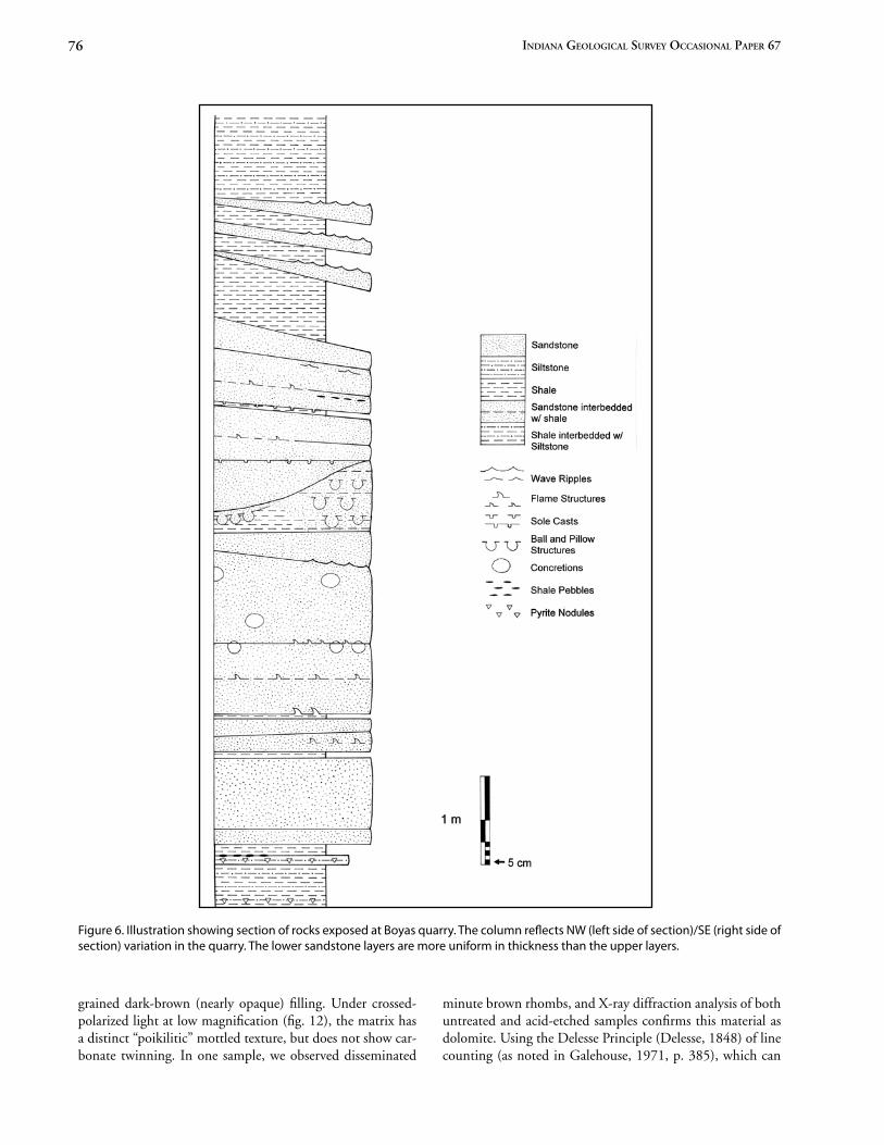
toward I-480. The locality is not far from the classic Granger Road (Highway 17) cut of Pepper and others (1954, fig. 53), and Szmuc (1970, fig. 6), which is now poorly exposed. The Boyas quarry was opened in the 1970s. The Euclid there is about 18 ft (5.5 m) thick (with some lateral variability). The sandstone beds vary in thickness, from about 6.7 in (17 cm) to up to about 3.3 ft (1 m). Thin shale partings commonly separate sandstone beds. The basal sandstone beds retain more or less constant lateral thickness, about 11.5 ft (3.5 m), across the cut face of the quarry (figs. 5–7).
The Euclid at the Boyas quarry exhibits many classic sedimentary structures, including ball-and-pillow structures (fig. 7), flame structures (figs. 8–9), convoluted bedding, and various sole markings including flute casts. It also contains shale pebbles, pyrite nodules, and large, oblate (up to about 16.5 in [42 cm] high by 39 in [98 cm] horizontal diameter), concretionlike structures. Van Horn (1931, p. 108) noted con-cretions in the Euclid at Newburg.) Wave ripples occur spo-radically in the main sandstone sequence and are common in the flaggy beds of sandstone above (fig. 7). These sedimentary features also occur at other sites where the Euclid crops out (see Pashin and Ettensohn, 1995, fig. 46).
The quarrying techniques used at the Boyas quarry are unusual, contrasting with those used in quarrying the Eu-clid bluestone during the early and middle twentieth century. At this quarry, workers first removed the overlying gray and red shales of the Bedford Formation and then used a load-er to scoop up a large iron wrecking ball and drop it onto an exposed layer of bluestone. If properly done, the iron ball (fig. 10) cracked the rock and did not roll. The rock layers broke naturally into large blocks that were easily pulled away from the edge of the outcrop using an excavator. The stone broke into roughly cubic blocks because the Euclid’s horizon-tal bedding and vertical joint sets occur nearly at right angles. Berkey (1908, p. 150) noted similar jointing in New York bluestone. These rough, broken rock faces commonly exhibit plume structures—feather patterns that develop along joint faces.
Stone from the Boyas quarry can be seen at localities all around Cleveland. The stone is used for shore armoring along much of the Cleveland shoreline. It has also been used exten-sively for ornamental stone at places such as the Cleveland Metroparks Zoo.
Composition of the Stone at the Boyas Quarry
Previous Descriptions. Pashin and Ettensohn (1995, p. 16) determined the Bedford-Berea siltstone (that is, the Eu-clid) to be composed of monocrystalline quartz, with some mica and a clay-mica matrix. They found it to be cemented mainly by quartz, with lesser ferroan calcite and framboidal marcasite. The Corps of Engineers (T. Stransky, oral commun., 1981) found samples of the Euclid from the Boyas quarry to be composed of subangular quartz and some lithic particles,
Figure 5. Photograph (2001) of the Bedford Formation, includ-ing Euclid bluestone, exposed in the Boyas quarry (locality 2 on Figure 1). Upper third of the section seen is composed of gray shale; most of remainder is Euclid bluestone. Measuring staff is marked in decimeter increments. The two thick beds of sand-stone are about 3.3 ft (1 m) thick.
all cemented with silica. They also found it to have interstitial calcite and framboidal pyrite.
Analysis. The following description is based on X-ray diffraction and petrographic analyses. The Euclid bluestone from the Boyas quarry is a very fine grained (<125 µ) dolo-mitic micaceous quartz sandstone. Fresh samples typically are nonfissile, dense (2.45–2.75, n = 8), and light-gray in color (Munsell rock-color chart). Thin sections of fresh Euclid re-veal abundant detrital quartz, albite (±microcline), muscovite, chlorite (±biotite), and accessory minerals (zircon, apatite, and magnetite), all enclosed in a ferroan-dolomite matrix (figs. 11–13).
The matrix, in hand sample and plane-polarized light, closely resembles the clay matrix of a classic graywacke. Un-der plane-polarized light the matrix appears as a very fine
76 indiana geological survey occasional PaPer 67
Figure 6. Illustration showing section of rocks exposed at Boyas quarry. The column reflects NW (left side of section)/SE (right side of section) variation in the quarry. The lower sandstone layers are more uniform in thickness than the upper layers.
grained dark-brown (nearly opaque) filling. Under crossed-polarized light at low magnification (fig. 12), the matrix has a distinct “poikilitic” mottled texture, but does not show car-bonate twinning. In one sample, we observed disseminated
minute brown rhombs, and X-ray diffraction analysis of both untreated and acid-etched samples confirms this material as dolomite. Using the Delesse Principle (Delesse, 1848) of line counting (as noted in Galehouse, 1971, p. 385), which can

77Proceedings of the 40th forum on the geology of industrial minerals
be applied to printed photomicrographs of acid-etched thin sections, the dolomite accounts for roughly 25 percent by volume of this rock, clearly placing it in the “wacke” sand-stone classification according to Pettijohn and others (1987, p. 144). Furthermore, this classification scheme does not count the abundant detrital micas as framework grains for determin-ing classification.
Framework grains are dominantly quartz, which are very angular to sub-angular, sub-prismoidal to sub-discoidal (fol-lowing Powers, 1989, sheet 30.1), and range from 60 to 100 microns in length. There is a strong preferred alignment of inequant grains parallel to bedding, resulting in a “sedimenta-ry” fabric that facilitates horizontal cleaving. Similar planes of splitting have been called “reeds” in the New York bluestone area (Dickinson, 1903, p. 7; Bowles, 1917, p. 94–95) and are generally known as “rifts” in the dimension stone indus-try (Merrill, 1891, p. 436). Most quartz grains in the Euclid bluestone are monocrystalline with either unit extinction or weak undulatory extinction. Feldspar grains typically show al-bite-twinning (rarely “tartan” microcline twinning) and have abundant inclusions. The feldspar grains show signs of de-composition. Mica grains, predominantly clear muscovite, lie in the plane of bedding, and are commonly bent around adjacent framework grains, which most likely were pressed into the mica during compaction and burial. Most frame-work grains, when touching, commonly show impinging or embayed contacts. The quartz grains are rarely sutured, and only one grain was observed with an overgrowth.
The angularity of the quartz, the presence of feldspar, and abundant mica grains suggest that this material was not in transit very long. Although not well sorted by composition (namely, it is an immature sandstone according to the termi-nology of Tucker, 2001, p. 20), the grains are uniform in size. Sorting such as this is typical of deep-water graywackes that are carried long distances and deposited far from their source in one swift event such as a low-density turbidity currents or gravity slumps (Shelley, 1985).
Figure 7. Photograph (2001) of Euclid bluestone exposure at Boyas quarry in Valley View. Sandstone beds of various thick-nesses, separated by thin shale partings, can be seen. Vertical and subvertical joints are also present. Also note the ball-and-pillow structures in the layer just a few inches beneath the feet of two geologists.
Figure 8. Photograph (2001) of a large (33.5 by 31 inches [85 by 80 cm]) quarried block of Euclid bluestone at Boyas quarry showing flame structures as seen from below.
Figure 9. Photograph showing flame structure consisting of wa-ter-laden clays injected upwards into the overlying sand. The photo is of a back-lit thin section 1 inch (2.5 cm) in height.
Figure 10. Photograph (2001) showing a large iron ball that was used to break stone layers at Boyas quarry. The ball is about 2.3 ft (about 7 decimeters) in diameter. The broken pieces are Euclid bluestone. The quarry wall is visible in the background.

78 indiana geological survey occasional PaPer 67
Pyrite. Pyrite is common in the Euclid, which has pre-vented its widespread use for building exteriors, unlike the Berea Sandstone, which has been used extensively for the ex-terior of buildings. When exposed to the atmosphere, the py-rite blebs in the Euclid decay, turning black. Iron and sulfur leaches into the surrounding rock, forming a reddish-brown to yellowish spot or streak. John Newberry (1873, p. 188) noted this, writing that the bluestone was a “fine, compact, and serviceable stone, but it contains considerable iron in the condition of sulfide.” Read (1879, p. 215) observed that this stone “requires … careful selection to exclude that containing iron sulfide, which by oxidation will color and disintegrate the stone.” And Merrill (1889, p. 458) noted it to be safe only for “bridge work and foundations or flagging, for which last purpose it is eminently suited.” Such pyrite-related spots can
Figure 11. Photomicrograph in plane-polarized light of typical Euclid bluestone from the Boyas quarry. Patchy carbonate ma-trix is visible surrounding grains, mostly quartz.
Figure 12. Photomicrograph in plane-polarized light of Euclid bluestone from the Boyas quarry. The left side has been etched with hydrochloric acid, removing the carbonate matrix from that side.
Figure 13. Photomicrograph of the Euclid bluestone from the Boyas quarry at higher magnification, showing abundant voids surrounding framework grains in the acid-etched rock.
Etched void space
Quartz Chlorite
be seen on structures made of Euclid bluestone, including sidewalks and the old Euclid City Hall building.
Comparison to Other Bluestones
The well-known bluestones (flagstones) of New York State (Hudson River Valley and south and central New York) and adjacent areas of northern Pennsylvania are Upper Devonian (Frasnian) Catskill wedge deposits (Krajewski and Williams, 1971; Albanese and Kelly, 1991). These deposits, including the Walton and Slide Mountain formations (Frasnian) of New York, are proximal portions of the Catskill wedge. Since at least the time of Julien (1879, p. 372; also quoted in Merrill, 1889, p. 454; 1891, p. 270), the New York flagstones have been classi-fied as graywackes. Recent workers have retained this litho-logic classification with some modifications for Pennsylvania and New York bluestones. Using Krynine’s classification, Kra-jewski and Williams (1971, fig. 33) have classified Pennsylva-nia bluestone as a low-rank graywacke. Albanese and Kelly (1991, p. 192–193), using the Krynine classification, classi-fied New York bluestone as a low-rank graywacke and, in the Pettijohn system, as a sub-graywacke. More recently, Alba-nese and Kelly (1995, p. 26) described the New York blue-stones as “moderately well sorted, fine to very fine sandstone composed of quartz with subordinate rock fragments and feldspar grains in a matrix of detrital and recrystallized clay minerals cemented by quartz with small amounts of calcite.”
Flagstones are chosen because of their ability to resist weathering. They are compact and relatively impermeable (Julien, 1879, p. 372). Traditional bluestones of New York State, which have also been called graywacke, contain chlorite and other minerals that make them less permeable and more durable, what Berkey (1908, p. 154) in his analysis of New York bluestones called incipient metamorphism.
79Proceedings of the 40th forum on the geology of industrial minerals
Krajewski and Williams (1971, p. 152) noted that the resistance of Pennsylvania flagstone was due to “the character and higher percentages of secondary, fibrous clay minerals” when compared to lesser resistance of samples of Tennessee flagstone. Their sodium-sulfate soundness testing (p. 129) showed that permeability was the major factor in the amount of resistance to weathering.
The Euclid is similar in overall composition to the New York bluestones. However, the Euclid differs from these other bluestones in being generally finer-grained and having do-lomitic cement. Sandstones of the southern Appalachians, however, can have ferroan dolomite/ankerite cement (Millik-en, 1998). The interlocking dolomitic cement of the Euclid strengthens the rock and makes it denser, helping to give the Euclid bluestone its durability.
Depositional Environment of the Euclid
The Euclid is part of a generally coarsening-upward se-quence of Upper Devonian (Famennian) rocks (Ohio Shale through Berea Sandstone) that were deposited in a foreland basin to the west of the Acadian Mountains. The deposits are distal Catskill wedge/distal Appalachian Basin deposits. The Euclid was deposited at the beginning of an episode of regional shoaling, which is a relative lowering of sea level, and it was deposited on top of fine-grained muds and silts of the lower part of the Bedford Formation.
The New York and Pennsylvania bluestones (Frasnian) have been interpreted as originating as much shallower, more proximal Catskill-facies rocks, as offshore bars and tidal channel deposits (Krajewski and Williams, 1971; Albanese and Kelly, 1991). The slightly younger Euclid bluestone (Famennian) is a distal Catskill wedge deposit composed of finer material than the more proximal New York and Pennsylvania bluestones.
The Euclid bluestone shows evidence of rapid transport and deposition. Wave ripples and hummocky strata are com-mon sedimentary structures of the Euclid. Both structures are known to be associated with deposition during periods of sig-nificant storming. Other structures also found in the Euclid include current ripples and groove casts, structures common in turbidity currents, as well as flame structures (figs. 8 and 9), which are indicative of rapid loading. Additionally, the Euclid tends to be massive, having thick beds that lack inter-nal sedimentary structures such as graded bedding and cross beds, indicative of quick, punctuated deposition.
Various scenarios have been proposed for deposition of the Euclid bluestone and the underlying and overlying rocks of the Bedford Formation. In a now classic study, Pepper and others (1954, p. 102, fig. 13B, and reiterated by Szmuc, 1970, p. 30) interpreted the Euclid bluestone to be an off-shore barrier-bar complex. Coogan and others (1981, p. 133) interpreted the unit as representing rapidly emplaced distal bars that developed on a slope break. The latest work on the depositional environment of the Euclid is that of Jack Pashin and Frank Ettensohn (1995) who studied it as part of a larger
study of the Bedford Formation and Berea Sandstone. These workers determined (1995, p. 45) that the unit consists of localized, storm-related deposits that accumulated on a shelf margin. Analysis of detrital micas from the Bedford Forma-tion by Aronson and Lewis (1994) and Lux and Wells (1994) identified an Appalachian, Acadian Orogeny, source area.
The angularity of the quartz and the abundance of de-trital mica grains suggest short transit time, possibly along an outer delta slope (Shelley, 1985, p. 25, 249). Although not well sorted compositionally (namely, it is an immature sandstone in the sense of Tucker, 2001, p. 20), the silicate-framework grains are uniform in size, which is typical of deepwater graywackes that were deposited via a low-density turbidity current or gravity-slump mechanism (Shelley, 1985, p. 249; Tucker, 2001, p. 84). That is, the sorting is typical of sands carried long distances and deposited far from their source in one swift event. Convoluted bedding is suggestive of motion, and load casts, ball-and-pillow structures, and flame structures are indicative of rapid loading (Tucker, 2001, p. 35–36).
We interpret the beds in the Euclid to have been de-posited from long-range but swiftly traveling storm events that brought material from the mouth of one or more large rivers that were eroding rising metamorphic terrains to the northeast. This is consistent with the interpretation by Pa-shin and Ettensohn (1995, p. 45). Our interpretation of the Euclid sandstone as a turbidite “wacke” is consistent with classic studies of graywackes as flysch arenites (Crook, 1974). Furthermore, the abundance of syndepositional sedimentary structures—sole marks, flute casts, ripple marks, and convo-lute bedding—seen in outcrops suggests gravity-flow mecha-
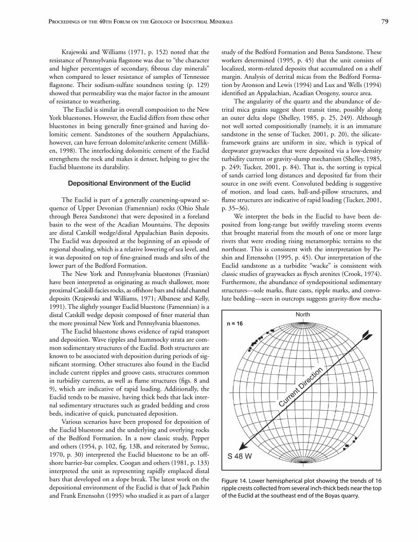
Figure 14. Lower hemispherical plot showing the trends of 16 ripple crests collected from several inch-thick beds near the top of the Euclid at the southeast end of the Boyas quarry.

80 indiana geological survey occasional PaPer 67
nisms such as turbidity currents. Paleocurrent directions from ripple marks at the Boyas quarry indicate that transport was from northeast to southwest (S48W, n = 16) (fig. 14), which is in general agreement with the measurements of Pashin and Ettensohn (1995, fig. 16) in this part of Cuyahoga County. Pashin and Ettensohn, however, show a wide range of direc-tions over the outcrop area of the siltstone and gray shale lithofacies of the Bedford-Berea sequence.
Acknowledgments
We thank the Boyas Company for access to their quarry, Claire Sturm for help in the field, and Greg Petusky for print-ing most of the photos. Benjamin Scherzer’s and Claire Sturm’s work on this project was supported by the Kirtlandia Society Adopt-A-Student Program of the Cleveland Museum of Natu-ral History. Portions of this project used equipment funded by National Science Foundation Award 0216039 (J. B. Keiper, primary investigator). The Department of Geological Scienc-es at Case Western Reserve University provided access to its Phillips X-ray diffraction equipment. The Corps of Engineers and W. Kelly, New York State Museum, and Lynn Conway and others at Georgetown University provided information. M. Hackathorn and K. Farago read over versions of the manu-script. We also thank two anonymous reviewers for their com-ments on the manuscript.
References
Albanese, J. R., and Kelly, W. M., 1991, History, economy, and ge-ology of the bluestone industry in New York State: New York State Geological Association 63rd Annual Meeting Field Trip Guidebook, p. 191–203.
———, 1995, Bluestone–geology and resource identification in the southwestern Catskill Delta of New York State: Geological Soci-ety of America Abstracts with Programs, v. 27, no. 1, p. 26.
American Architect and Building News, 1880, The illustrations–new college building at Georgetown, D. C. Messrs. Smith-Meyer and Pelz, Architects: v. 7, no. 222, March 27.
Aronson, J. L., and Lewis, T. L., 1994, Ages of detrital white mica from Devonian-Pennsylvanian strata of the north central Appa-lachian Basin–dominance of the Acadian Orogen as provenance: Journal of Geology, v. 102, p. 685–696.
Bauer, A., Hannibal, J. T., Hanson, C. B., and Elmore, J. V., 2002, Distribution in time, provenance, and weathering of gravestones in three northeastern Ohio cemeteries: Ohio Journal of Science, v. 102, no. 4, p. 82–96.
Berkey, C. P., 1908, Quality of bluestone in the vicinity of the Asho-kan dam: School of Mines Quarterly, v. 29, p. 149–158.
Bowles, O., 1917, Sandstone quarrying in the United States: U.S. Bureau of Mines Bulletin 124, 143 p.
———, 1939, The stone industries (2nd ed.): New York, McGraw-Hill, 519 p.
Bownocker, J. A., 1915, Building stones of Ohio: Ohio Division of Geological Survey Bulletin 18, 160 p.
Butler, M. M., 1963, A pictorial history of the Western Reserve, 1796 to 1860: Cleveland, Early Settlers Association of the Western Re-serve and the Western Reserve Historical Society, 155 p.
Carey, A., 2006, What’s the deal with … Squire’s Castle: Plain Deal-er, March 20, p. A2.
Cleveland Press, 1970, City Hall is landmark but new one is planned: Cleveland Press Classified Advertising Supplement, June 8, p. 16.
Coogan, A. H., Heimlich, R. A., Malcuit, R. J., Bork, K. B., and Lewis, T. L., 1981, Early Mississippian deltaic sedimentation in cental and northeastern Ohio, in Roberts, T. G., ed., Geological Society of America Cincinnati ‘81 Field Trip Guidebooks, v. 1, Stratigraphy, sedimentology: Falls Church, Va., American Geological Institute, p. 113–152.
Crook, K. A. W., 1974, Lithogenesis and geotectonics–the signifi-cance of compositional variations in flysch, in Dott, R. H., Jr., and Shaver, R. H., Modern and ancient geosynclinal sedimenta-tion: Society of Economic Paleontologists and Mineralogists Spe-cial Publication 19, p. 304–310.
Cushing, H. P., Leverett, F., and Van Horn, F. R., 1931, Geology and Mineral Resources of the Cleveland District, Ohio: U.S. Geologi-cal Survey Bulletin 818, 138 p.
Delesse, A., 1848, Procede mechanique pour determiner la compo-sition des roches: Annales des Mines, v. 13, p. 379–388.
de Witt, W., Jr., 1951, Stratigraphy of the Berea sandstone and associ-ated rocks in northeastern Ohio and northwestern Pennsylva-nia: Bulletin of the Geological Society of America, v. 62, p. 1,347–1,370.
Dickinson, H. T., 1903, Quarries of bluestone and other sandstones in the Upper Devonian of New York State: New York State Mu-seum Bulletin 61, 112 p.
Durkin, J. T., 1963, Georgetown University–the middle years (1840–1900): Washington, D.C., Georgetown University Press, 333 p.
Flaningam, J. S., 1934, Forgotten bluestone–Cleveland’s ghost sub-urb: Cleveland Plain Dealer Magazine Section, September 30, p. 6–7.
Galehouse, J. S., 1971, Point counting, in Carver, R. E., ed., Proce-dures in sedimentary petrology: New York, Wiley, p. 385–425.
Garlick, T., 1869, Unpublished memoranda of his life: Cleveland, Archives of the Western Reserve Historical Society, manuscript.
Hannibal, J. T., 1985, The Berea grit: Western Reserve, v. 11, no. 6, p. 50–53.
———, 2006, Guide to the building stones and cultural geology of Akron: Ohio Division of Geological Survey Guidebook 19, 75 p.
———, 2007, Teaching with tombstones–geology at the cemetery, in Shaffer, N. R., and DeChurch, D. A., Proceedings of the 40th Forum on the Geology of Industrial Minerals: Indiana Geological Survey Occasional Paper 67, p. 82–88.
Hannibal, J. T., and Foos, A. M., 2003, Historical significance of the Sharon Formation in northeast Ohio, in Foos, A., ed., Pennsylva-nian Sharon Formation, past and present–sedimentology, hydroge-ology, and historical and environmental significance–a field guide to Gorge Metro Park, Virginia Kendall Ledges in the Cuyahoga Valley National Park, and other sites in northeast Ohio: Ohio Divi-sion of Geological Survey Guidebook 18, p. 38–47.
Hannibal, J. T., and Palermo, A., 1980, Sidewalk geology: Explorer, v. 22, no. 1, p. 25–30.
Hannibal, J. T., Saja, D. B., Thomas, S. F., and Hubbard, D. K., 2006, Quarrying history and use of Berea Sandstone in northeast-ern Ohio, in Reid, J. C., ed., Proceedings of the 42nd Forum on the Geology of Industrial Minerals, May 7–13, 2006, Asheville, N.C.: North Carolina Geological Survey Information Circular 34, p. 195–214.

81Proceedings of the 40th forum on the geology of industrial minerals
Historic American Buildings Survey, after 1933, Georgetown Uni-versity, Healy Building, photographs, written historical and de-scriptive data: National Park Service, HABS No. DC-248, 41 p.
Julien, A. A., 1879, On the geological action of the humus acids: Proceedings of the American Association of the Advancement of Science, v. 28, p. 311–410.
Kilbourn, J., 1833, The Ohio gazetteer, or topographical dictionary, being a continuation of the work originally compiled by John Kil-bourn (11th ed., revised and enlarged by a citizen of Columbus): Columbus, Ohio, Scott and Wright, 512 p.
Krajewski, S., and Williams, E. G., 1971, Upper Devonian flagstones from northeastern Pennsylvania: Pennsylvania State University Col-lege of Earth and Mineral Sciences, Special Publication 3-71, 185 p. [Krajewski is listed as single author on the title page.]
Lake, D. J., 1874, Atlas of Cuyahoga County, Ohio: Philadelphia, Titus, Simmons and Titus, 205 p. [reprinted, 1976, by Unigraph-ic, Evansville, Ind.].
Lewis, T. L., 1988, Late Devonian and Early Mississippian distal ba-sin-margin sedimentation of northern Ohio: Ohio Journal of Sci-ence, v. 88, no. 1, p. 23–39.
Lux, D. R., and Wells, N. A., 1994, 40Ar/39Ar dating of coarse de-trital muscovites from latest Devonian to Middle Pennsylvanian sandstones of northern Ohio: Geological Society of America Ab-stracts with Programs, v. 26, no. 3, p. 57–58.
Merrill, G. P., 1889, The collection of building and ornamental stones in the U.S. National Museum–a hand-book and catalogue: An-nual Report of the Board of Regents of the Smithsonian Institu-tion … for 1886, Part II, p. 277–648.
———, 1891, Stones for building and decoration: New York, Wiley, 453 p.
Miller, G., Spelman, E., Boyer, K., and Boyer, R., 1979, The story of Independence: Independence, Ohio, Independence Historical Society, 248 p.
Milliken, K. L., 1998, Carbonate diagenesis in non-marine foreland sandstones at the western edge of the Alleghanian overthrust belt, southern Appalachians, in Morad, S., ed., Carbonate cementa-tion in sandstones: International Association of Sedimentologists Special Publication 26, p. 87–105.
Morse, W. F., and Foerste, A. F., 1909, The Waverley formations of east-central Kentucky: Journal of Geology, v. 17, p. 164–177.
Newberry, J. S., 1873, Report on the geology of Cuyahoga County: Report of the Geological Survey of Ohio, v. 1, part 1, Geology, p. 171–200.
Orton, E., 1884, Sandstone: Ohio Geological Survey, v. 5, p. 578–607. Ostrowski, D. F., 2001, A history of the Mill Creek waterfall: Self-
published, 36 p. Palermo, A., 1979, Cuyahoga County’s ghost town: Western Reserve
Magazine, v. 7, no. 1, p. 54–56. Pashin, J. C., and Ettensohn, F. R., 1995, Reevaluation of the Bed-
ford Berea sequence in Ohio and adjacent states–forced regression in a foreland basin: Geological Society of America Special Paper 298, 68 p.
Pepper, J. F., de Witt, W., Jr., and Demarest, D. F., 1954, Geology of the Bedford Shale and Berea Sandstone in the Appalachian Basin: U.S. Geological Survey Professional Paper 259, 111 p.
Persche, R. F., 1939, Report of the Civilian Conservation Corps, Camp Euclid, National Park Service Co-operation: Report of the Board of Park Commissioners of the Cleveland Metropolitan Park District, 1938–1939, p. 43–48.
Pettijohn, F. J., Potter, P. E., and Siever, R., 1987, Sands and sand-stones (2nd ed.): New York, Springer Verlag, 553 p.
Post, C. A., 1930, Doans Corners and the city four miles west: Cleve-land, Caxton Co., 210 p.
Powers, M. C., 1989, Comparison chart for estimating round-ness and sphericity, in Dutro, J. T., Dietrich, R. V., and Foose, R. M., compilers, AGI data sheets for geology in the field, labora-tory, and office: Alexandria, Va., American Geological Institute, sheet 30.1.
Prosser, C. S., 1912, The Devonian and Mississippian formations of northeastern Ohio: Ohio Division of Geological Survey, v. 11, Bulletin 15, p. 323–871. [This bulletin was also published sepa-rately with different pagination.]
Read, M. C., 1879, Geology, in Johnson, C., compiler, History of Cuyahoga County, Ohio, p. 214–220.
Rock-Color Chart Committee, 1995, The Geological Society of Amer-ica rock-color chart, 8th printing: Boulder, Colo., Geological So-ciety of America, 9 p.
Sanborn Map Company, 1886, Insurance maps of Cleveland/New York: Sanborn Map and Publishing Company.
Shelley, R. C., 1985, Ancient sedimentary environments and their sub-facies diagnosis, 3rd ed.: New York, Cornell University Press, 317 p.
South Euclid Golden Jubilee Book Committee, 1967, The proud heri-tage of South Euclid, Ohio: South Euclid, Ohio, 80 p.
Szmuc, E. J., 1970, The Mississippian System, in Banks, P. O., and Feldmann, R. M., eds. Guide to the geology of northeastern Ohio: Cleveland, Northern Ohio Geological Society, p. 23–67.
Taylor, A. D., 1938, Forest Hills Park, a report on the proposed land-scape development–prepared for the City of Cleveland Heights, Ohio, the City of East Cleveland, Ohio: Cleveland, 104 p.
Tucker, M. E., 2001, Sedimentary petrology–an introduction to the origin of sedimentary rocks, 3rd ed.: Boston, Blackwell Scientific Publications, 262 p.
U.S. Census, 1850–1880, Federal nonpopulation census schedules, Ohio: In the custody of the State Library of Ohio, Products of Industry.
U.S. Centennial Commission, 1876, Official catalogue of the In-ternational Exhibition of 1876, part 1: Philadelphia, Centennial Catalogue Co., 464 p.
Van Horn, F. R., 1931, Economic geology, in Cushing, H. P., Lever-ett, F., and Van Horn, F. R., Geology and mineral resources of the Cleveland District, Ohio: U.S. Geological Survey Bulletin 818, p. 104–133.
Washington Post, 1879, Its centennial pile–the new home intended for the Georgetown University–a massive and magnificent struc-ture in course of erection for educational purposes–full descrip-tion of the building, which will be finished in June–notes: April 18, p. 1.
Whittlesey, C., 1838, Mr. Whittlesey’s report, in Second annual re-port on the Geological Survey of the State of Ohio: Columbus, p. 41–71.
Wolfe, M. E., compiler, 2002, 2001 Report on Ohio mineral in-dustries with directories of reporting coal and industrial mineral operators: Ohio Division of Geological Survey, 155 p.