The environmental re '"'earch field ite ''H'orkhein1er In el": Re earch ...
11
The environmental re '"'earch field ite ''H'orkhein1er In el": Re earch program instrumentation and first re ults Le ite de recherche ur l'environn1ent ''Horkheimer In el": Programme de recherche . ' In trun1entation et premiers re ultat BS-I R Cl C1. U I C 11 lnrtlfut fur U aHerbau. l. mw•rW\ of Stuttgart, StuttKart. Fed Rt:p. of German!' H.KOBUS lnsmut fur WaHerbnu, vf Sruugarr, Stultgart, Fed. Rep. of Germany In order to c rry out od and related field expenment under controlled natural cond1tion , an envtronmentul test stle has been set up m July 1987 on the "Horkhetmer Inset", 70 km north of tuttgnn. At pre cnt, the interd1 caphnal) re earch program compnse one groundwater proJeCt, t"o prOJeCt dealing with the un aturat d lone and the sotl, and one environmental databa e prOJect The 2 ha field site exten i\ely compming 24 rnultile\el groundwat r ob'icrv.tuon- and pumptng-well , a large monolithiC ly<itmeter, a meterologtcal tatJOn. a well a numerous tensiometer nd .;uction cup . In order to facilitate the commumcallon and data exchange bet\ een the cooperatmg umvcr:dty in titutes. a dt ·tributed datnba e y tem 1 betng developed Durmg the imtial phase ot the uwe ttgntion , the field . ite ha'> been extensively de cribed m terms of underground tructure, a "ell :. the soil und aqutfer parameters. ·y he inve tigation program IS pre ·ented together "ith fir t re ·ults of the ongoing lie Id expenmcnt . Mf. fin d'etTectuer de· experience· cornbmees ol-eau outerrume · de'> condit1ons naturelle controlees, un sit -te t de recherche ur l'env•ronnernent a ete equipe enjutllet 19 7 sur l'ile "Horkheimer In ·et", ituee a 70 km u nord de tuttgan l'hcure actuellc. le progmmme de recherche tnterdisctplinatre comprend un prOJet sur les eaux outerraine , deu.· projets portant ur I zone non aturee et le. ol am i qu'un projet ur la conslltutton d'un ba ·e de donnee., ur l'environn ment Le ;.,tte expenmentul de 2 hd C\t nhtrumente de exten-;ive et comprcnd 24 puit de et d'ob ervat•on a dllferents ntveaux, un lysimetre il grand dmmetrc. une tntton metcorologtque, tn i que de nombreux ten tometre et bougie:- poreu"e' Dans le but de facthter la communication et l'echange de donnees entre le instttuts de. umver'tte tmphquec . un systcme de ba'>e de donnees a ete deveJoppe Pendant I phase iniuale de· mve ttgat10ns, le a ete decnt de extensive en terme de structure du ol et du ous- ol et de pammctrcs de l'aqutfere. Le programme d'uwesttgattons et le' premiers re ultat de experiences ,e dCroulant sur le terrain sont presentee; ici. Introduction ll b generally accepted that environmental re earch programs require ,m interdisciplinary Thi 1 e ·pecially true for -otl and groundwater quality inve<;tlgations v. here numerous complex chemical, biologi al and hydromechamcal proce- ·e and their mteractiOn' have to be analysed. Revi ion received December 12, 19 9. Open for di cu -.ion tall I·ebruary 28. 1991 JO RNAI OF HYDRAULIC RE EARCH. VOL 2 . 1990. 4 491
Transcript of The environmental re '"'earch field ite ''H'orkhein1er In el": Re earch ...

The environmental re '"'earch field ite ''H'orkhein1er In el": Re earch program instrumentation and first re ults
Le ite de recherche ur l'environn1ent ''Horkheimer In el": Programme de recherche . ' In trun1entation et premiers re ultat
BS-I R Cl
C1. Tl~ U I C 11 lnrtlfut fur U aHerbau. l. mw•rW\ of Stuttgart, StuttKart. Fed Rt:p. of German!'
H.KOBUS lnsmut fur WaHerbnu, Cntverrr(~' vf Sruugarr,
Stultgart, Fed. Rep. of Germany
In order to c rry out od and ground~.tter related field expenment under controlled natural cond1tion , an envtronmentul re~eurch test stle has been set up m July 1987 on the "Horkhetmer Inset", 70 km north of
tuttgnn. At pre cnt, the interd1 caphnal) re earch program compnse one groundwater proJeCt, t"o prOJeCt dealing with the un aturat d lone and the sotl, and one environmental databa e prOJect The 2 ha field site ~:> exten i\ely in~trumented. compming 24 rnultile\el groundwat r ob'icrv.tuon- and pumptng-well , a large monolithiC ly<itmeter, a meterologtcal tatJOn. a well a numerous tensiometer nd .;uction cup . In order to facilitate the commumcallon and data exchange bet\ een the cooperatmg umvcr:dty in titutes. a dt ·tributed datnba e y tem 1 betng developed Durmg the imtial phase ot the uwe ttgntion , the field . ite ha'> been extensively de cribed m terms of underground tructure, a "ell :. the soil und aqutfer parameters. ·y he inve tigation program IS pre ·ented together "ith fir t re ·ults of the ongoing lie Id expenmcnt .
RE..~ Mf. fin d'etTectuer de· experience· cornbmees ol-eau outerrume · dan:~ de'> condit1ons naturelle controlees,
un sit -te t de recherche ur l'env•ronnernent a ete equipe enjutllet 19 7 sur l'ile "Horkheimer In ·et", ituee a 70 km u nord de tuttgan
l'hcure actuellc. le progmmme de recherche tnterdisctplinatre comprend un prOJet sur les eaux outerraine , deu.· projets portant ur I zone non aturee et le. ol am i qu'un projet ur la conslltutton d'un
ba ·e de donnee., ur l'environn ment Le ;.,tte expenmentul de 2 hd C\t nhtrumente de fu~on exten-;ive et comprcnd 24 puit de ~aplage et d'ob ervat•on a dllferents ntveaux, un lysimetre il grand dmmetrc. une tntton metcorologtque, tn i que de nombreux ten tometre et bougie:- poreu"e' Dans le but de facthter la
communication et l'echange de donnees entre le instttuts de. umver'tte tmphquec . un systcme de ba'>e de donnees a ete deveJoppe Pendant I phase iniuale de· mve ttgat10ns, le ~lle a ete decnt de fa~on extensive en terme de structure du ol et du ous- ol et de pammctrcs de l'aqutfere. Le programme d'uwesttgattons et le' premiers re ultat de experiences ,e dCroulant sur le terrain sont presentee; ici.
Introduction
ll b generally accepted that environmental re earch programs require ,m interdisciplinary appror~h.
Thi 1 e ·pecially true for -otl and groundwater quality inve<;tlgations v. here numerous complex chemical, biologi al and hydromechamcal proce- ·e and their mteractiOn' have to be analysed.
Revi ion received December 12, 19 9. Open for di cu -.ion tall I·ebruary 28. 1991
JO RNAI OF HYDRAULIC RE EARCH. VOL 2 . 1990. ~0 4 491

Furthermore, in environmental research programs the problem of choosing the appropriate scale of investigation often arises. Regional field investigations generally provide inadequate or incomplete data sets and are very time consuming, whereas laboratory studies generally fail to reproduce field conditions. Properly designed field experiments under controlled conditions are therefore considered a preferred alternative. Due to the considerable , infrastructure usually involved, these experiments are costly; however they are likely to provide the best possible results in terms of data diversity, data resolution and completeness, as well as data quality. Based on this concept and a feasibility study prepared by the Institut fUr Wasserbau at Stuttgart ·· University· [3], the PWAB (Projekt Wasser-Abfall-Boden) scientific committee decided to support financially the set up of an environmental research field site on the "Horkheimer lnsel'', 70 km north of Stuttgart. Fig. I shows a block diagram of the northern area of the site. The entire site covers an area of about 2 ha, situated between the Neckar canal in the east and the Neckar river in the west. The aquifer is formed by 2 to 5 meters of alluvial sand and gravel and is overlain by silty clays and loam with thicknesses ranging between 4 and 5 meterS. Intercalated mud- and limestones form the underlying aquiclude at depths between 8 and 9 meters below ground surface. The alluvial aquifer is generally unconfined with piezometric levels ranging between 5 and 6 meters below ground. Since July 1987an interdisciplinary research program is conducted at the experimental site, the overall objective of this program being the development and improvement of soil and groundwater protection methods. Participating researchers are hydrogeologists, civil engineers, agri-
PWAB - EnvironmentAl Research Field Site
"Horltheimer Insel,.
~~~ • • . ' ..
FIELD I
<~>-~- 15>·~--~~-- · ----
Fig. 1. The "Horkheimer lnsel" environmental research field site (northern field). Le site de recherche sur l'environnement "Horkheimer lnsel" (champ nord).
JOURNAL DE RECHERCHES HYDRAULIQUES. VOL 28, 1990, NO. 4

cultural engineers, agrobiologists, chemists, and computer scientists. The work is organized in four projects at three universities in Bad en~ WUrttcmberg, each project covering a different aspect of the "Horkheimer lnsel" research program [1]. One project deals with the groundwater contamination assessment and rehabilitation problems encountered in agricultural and industrial areas. Two projects investigate the water quality in the unsaturated zone comparing conventional and low-agrochemicals farming techniques. The last project organises the entire data-administration aspects employing a specially adapted environmental database system.
Projects
Development o.fmeasuring-, investigation-, and monitoring-methodsjorrhedetection and evaluation
l~( groundwater and soil contaminations (lnstitut jiir Wasserbau, Universi(Y of Stuttgart). A prerequisite for soil or groundwater contamination assessment or for contamination risk analyses is the determination of the ~nderground structure, together with the governing underground parameters and their variability. At the "Horkheimer Inset" experimental site a number of difTerent underground investigation and measuring methods are employed in parallel for comparison purposes. They include drilling, surface and borehole geophysics, pumping-tests, tracer-tests, and laboratory measurements. The information redundancy obtained through the parallel application of the methods will help to define practical guidelines for future soil and groundwater contamination studies. These will include recommendations concerning appropriate method combinations, data density and data quality requirements. The first project phase comprised the drilling of24 wells. Four of them are screened in the underlying bedrock formation, the rest being completed as 6" wells in the overlying alluvial aquifer. All wells can be used as pumping and as monitoring wells. Fig. 2 shows their location in the northern (FIELD I) and the southern (FIELD II) part of the experimental site. At present. more than half of the wells have been tested. The resulting transmissivity values range between 2.5 • to-2 and 4.0 • 10·-l m2/s yielding high groundwater flow velocities of up to 10 m/d. It should be noted however, that there is a high vertical variation in the velocity profile. The research program therefore emphasizes a detailed three-dimensional underground investigation within the experimental site. Due to the high aquifer transmissivities, the observed drawdowns are generally small, especially in distant observation wells. Therefore, accurate unsteady-state measurements can only be obtained using automatic data-logging equipment. The system comprises a magnetic-inductive flowmeter and up to 5 pressure transducers with a resolution of better than O.l cm and a maximum sampling rate of one reading per second. Using a portable computer, a preliminary evaluation of the data can be performed directly in the field. Twenty out of the 24 wells were cored from top to bottom. The undisturbed cores have been tested in specially constructed double-wall permcameters with a sample length of 25 cm. Fig. 3 shows some results from the three neighbouring wells P9, PIO. and Pl4. Even though there is a high variability in the measured values, two high permeability zones between 5.80 and 6.00 m and between 6.50 and 6.80 n1eters could be identified in all three wells. Sieve analyses are subsequently performed on all permeaincter samples. In case of notable layering the sample length is reduced down to 10 cm. It should be mentioned that, depending on the calculation method used, the hydraulic conductivities obtained from sieve analyses differ by an order of magnitude from the permeameter measurements.
JOURNAL OF HYDRAULIC RESEARCH. VOL. 28. 1990. NO. 4 493

494
FIELD I
FIELD 11
6 5 50 m
Fig. 2. Groundwater observation wells on the "Hork.heimer lnsel" experimental site.
Puits d'observation des eaux souterraines sur le site experimental "Hork.heimer fnsel".
depth[m) 5,0
6,0
7,0
8.0
Horkheim Permeameter-ktv P9
I t ''''"'I ' -6 -5
I · ·rft.
I .
k1 I .._, __ ..... ..., ........ _ ........ , ' I ... _,
I
P10 P14 -----
' 's· ... ;,, T ' ..... , ' . log(kf I [m/si -4 -3 -2
Fig. 3. Permeameter measurements- wells P9, PIO, and Pl4.
Mesures au moyen de permeametre- puits P9, PlO et Pl4.
JOURNAL DE RECHERCHES HYDRAULIQUES, VOL. 28. 1990, NO. 4

The pt::rmeability profiles obtained from the cores and the pumpingtest results are used for a three dimensional anal)''sis of the hydraulic conductivity variability throughout the experimental site. In the next project phase a number of natural and forced gradient tracer tests will be performed at the "Horkheimer Insel" test site. These tracer tests will be used to determine groundwater flow velocity profiles which will then be compared with the hydraulic conductivity profiles obtained from laboratory measurements. For this purpose, a special multi level sampler, the In-Line-Packer-System (ILPS), was developed to measure vertical concentration profiles using the existing fully screened observation wells [4]. One or more packer modules are inserted into the well and inflated to avoid vertical water circulation within the well. Numerous sampling points as close as 10 cm can be fitted to the elastic packer membrane. The sample inlets arc either connected to a pump or a suction tube. To avoid vertical flow within the gravel pack the sampling points can be operated simultaneously. Fig. 4 shows the ILPS after installation in a fully screened observation well. The final phase of the project includes the development of a three-dimensional groundwater flow and transport model for the test site area. This model will take into account not only the
Seal
Jn-Line-Packer-S}'1tem (rLPS)
- -- - -:... =- ... -... ~.;
•0 0 0 ••
0 0 •
• . o·
-
H;;ll
0 • : • . • : .... . ~ . . ~ . . . . . .
0. 0 •• 0 ••
·• .. . 0 0 . . .. 0
0 . • • •
0 -·~ . ·_.---if-Q::.- ~&;..-
0 ... •. 0 • • 0 : • • _. . ~
Grouadwater level
0 • - J: ---11-+.;:......Jt--....._;...,--Screen
.o:-:o·. 11{~~~~= .~-.··~_:· 0 • • •
• 0 , • o i-r =-~ :::_.:. o . ~ ',.:,.:.!-Aquifer . . .. · • 0 ~ . . • =.: :..:.=: c . . • .. .
Samplioa hlbe --.-. -:-.• ~ . • ·iL·."":±o-lt-:--t='~-~--1:-;:-:..:_::- ~=-:- · o · . .n Gravel pack
• • • • 0 :-.: ::-_.:-: =. ::-:: • 0 .• • . . . 0 •••
•· • · Li :::... -_-~;M- _.11 ---:- • • • .. : .; o r~~U'4r--"'r--~'-.LJ .'. o . . 0. . - .. --
•• • Cl
:::· ..;:: ~-· Samplina pump---<~.,.;._-1-~.~
0
0 0
• • • 0 . . .
. .. ·o .
... ..
Connector module
[lastic membrane (Rub~r)
• ·- -- 0 • •• ·0·
Samplin& point ---·-.... :~~....:...~~0..90 ~.--~-;_: '"~;;::;-~~--;:~,11- :.J-0-"0'+~-.-·: ~ ... : :_: ... ~ .·-~·- Deflatin& tube
•••• 0 • • • • •••
--~i:-:---+1-4-t;.,..-::.; ::_-...:. r- 0 • • • 0 • • lnflatjna fluid . 0 • - - - -- - o · .
. • :.=::-:. -=-.-...: · 1.'·~ :__:...:..;-Denatina pump 0 .• • . ~- 0 =---=-= ~-:. 0 ~0.
=---rJ~-:: ,;..--- .. ·o· . . 0 • • • lT=1 t;;=:'£'ll ••. o ·
Bottom s.eat-----:;~·;ot!fic~..ll~~--==-~- ~ ~~ 1 ~ r-=---M 11il .... ·l· =·~· _;:· _ o . ·o : 0 ~//////..t::: " ·. · 0
• • Bottom plate . . . ... L.:_:,..!:~~~~~::..:...J . ·. " .....
. .
Fig. 4. In-Line-Packer-System (ILPS) installed in a fully screened observation well . Systeme de packer en ligne installe dans un puits ct ·observation a crepine continue.
JOURNAL OF HYDRAULIC RESEARCH, VOl. 18, 1990. NO. 4 495
measured hydrogeological and hydromechanical parameters but also their geostatistical prop
erties. This model will ultimately be coupled with the unsaturated zone models developed by the soil scientists. Together, this will allow a unsaturated-saturated simulation for the fate and transport of the agro-chcmicals applied at the experimental site.
Transport processes and water quality in the unsaturated :one employing conventional and sustainable farming techniques (lnstitures at the University of J/ohcnheim and lnsriwt fiir RaJiochemie,
University t)( Karlsruhe - two proj<>cts). Todays farming requires the use of fertilizers and pesticides. Depending on product mobility, persistence and soil conditions these chemicals may accumulate in the upper soil zone and subsequently percolate to the groundwater surface. Therefore, the environmental aspects of farming, especially the possible threat to groundwater quality, have recently received increased attention. Consequently, a number of agricultural research projects focus on the development and optimization of practical and economical solutions to minimize the application and percolation of agro-chemicals into the underground. For the "Horkhcimer Inset .. field experiment a corn/winter-wheat crop rotation was selected. Two fields are operated in parallel for comparison purposes. In FIELD I standard farming techniques are employed using common quantities of pesticides and fertilizers. In FIELD lllower quantities of agro-chemicals are applied with reduced tillage. Table 1 summarizes the farming techniques employed on the two fields.
Table I. Farming techniques as employed on the conventional and the sustainable field Techniques culturales employees sur le champ convcntionnel et sur le champ a technique alternative
FIELD 1 (conventional agriculture)
1. Area! application of fertilizers and herbicides 2. High amounts of N-fertilizer
(e.g. 200 kg N/ha for corn) 3. Conventional soil tillage
(e.g. with fall ploughing)
FIELD 11 (sustainable agriculture)
l. Row application of fertilizers and herbicides 2. Reduced N·fertilization
(120 kg N/ha for corn) 3. Reduced soil tillage
(no ploughing) 4. Combined mechanical and chemical weed
control 5. Multiple fertilizer applications
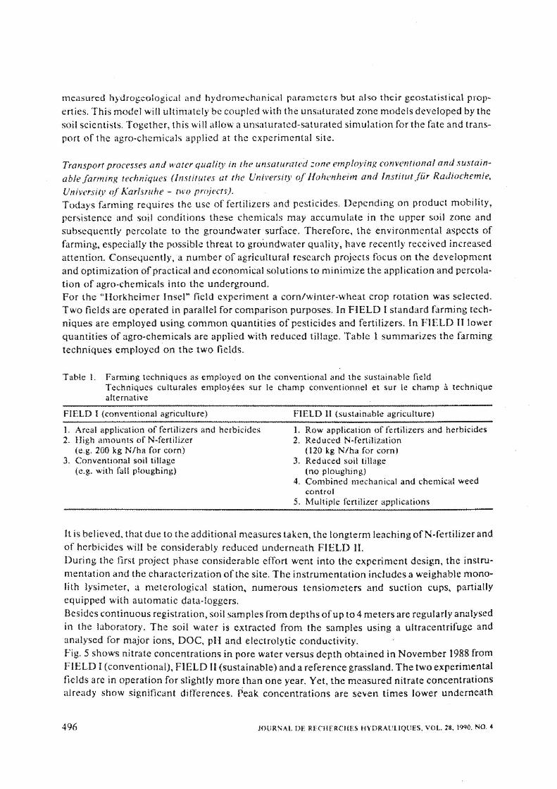
lt is believed. that due to the additional measures taken, the longterm leaching ofN-fertilizer and of herbicides will be considerably reduced underneath FIELD 11. During the first project phase considerable effort went into the experiment design, the instrumentation and the ch:uactcrization of the site. The instrumentation includes a weighable mono· lith lysimcter, a meterological station. numerous tensiometers and suction cups, partially equipped with automatic data-loggers. Besides continuous registration, soil samples from depths of up to 4 meters are regularly analysed in the laboratory. The soil water is extracted from the samples using a ultracentrifuge and analysed for major ions, DOC, pH and electrolytic conductivity. Fig. 5 shows nitrate .concentrations in pore water versus depth obtained in November 1988 from FIELD I (conventional), FIELD 11 (sustainable) and a reference grassland. The two experimental fields are in operation for slightly more than one year. Yet, the measured nitrate concentrations already show significant differences. Peak concentrations are seven times lower underneath
496 JOURNAL DE RECIIE RC liES IIYDRAULIQUES. VOL. 28. 1990, NO. 4

i I I
--v-grassland -e sustainabl-e field
-e- conventional field
Fig. 5. Nitrate concentrations versus depth (November 9, 1988).
Concentrations en nitrate en fonction de la profondeur (9 novembre 1988).
FIELD II. indicating a remarkable imorovement of the soil water quality. This becomes even more promising when considering the corn yields of7600 kg/ha in FIELD I as compared to 7200 kg/ha on FIELD H. Total NOrN as estimated based on the measured soil moisture and concentration profiles and assuming an average soil density of 1500 kg/m3 is shown in Table 2. Considering the entire profile, the values for the sustainable field are 42% lower than for the conventional field. Total N03·N between 100 cm and 400 cm below ground is even 65% lower underneath the sustainable thl\n underneath the conventional field. .
Table 2. Calculated toial NO>~N (November 9. 1988) Total cakule en N-N03 (9 novembre 1988)
FIELD 1 {conventional) FIELD 11 (sustainable) Grassland (no cultivation)
total NOrN
0 to 400 cm {kg/ha]
"190 110 ,60
lOO to 400 cm [kg/ha]
170 60 25
The change of N03-concentrations over time is shown in Fig. 6 for the conventional field. The depth-profiles were obtained during three measuring campaigns in winter 1988/1989. Between November and December the peak -moved downwards by about40 cm. The February profile indicates an increased nitrate input in the uppermost meter together with a general increase in the _ concentrations below 250 cm.
JOURNAL Of HYDRAULIC ltESEARCH. VOL 28, 1990. NO. 4 497

I J t I I l!» . 1J · 1t n!Iat~m/(trQ/IJ
9/IV88
J ' '· a· ·m a 11 11 rirate:-camtatal/ ( r.Q /I)
0 Jl C C I Ill IJI lC ,....~atkl\ I ( l!IJ I H
VtJ89 Fig. 6. Nitrate concentration depth-profiles underneath FlELD 1 (November 9. 1988, December 22, 1988,
and February 1, 1989). Profil des concentrations en nitrate sur le CHAMP I (9 novembre 1988, 22 decembre 1988 et 1 fehrier 19R9).
Further interpretation has to consider not only the water movement but also nitrification~denitri· fication processes. Fig. 7 shows the anion distribution depth-profiles in November 198& as measured underneath all three test sites. It is seen that the high nitrate concentrations at a depth .of200 cm underneath the conventional field are replaced by an increased bicarbonate conce.ntra~ tion underneath the sustainable field and an increased bicarbonate and sulfate concentration underneath the grassland. The increased bicarbonate and sulfate concentrations give strong evidcmce to significant denitriftcation underneath the grassland arid the sustainable field. Similar differences as observed for nitrate are expected ·for the pesticide concentrations. However, regular sampling and analysis is more time consuming .and more expensive. The
. '
required laboratory capacitie~ have recently been installed atthe University ofHohenheim and are expected .to be operational by mid 1989. The next project phase comprises the installation of a second large lysimeter on the sustainable field (FIELD ll). and an extension to the tensiometer and suction cups instrumentation network. Parallel to the field work, a number of mathematical models for the simulation of crop growth, unsaturated flow. as well as nitrate and pesticide transport are being developed.
498 JOURNAL DE RECHERCHES HYDRAULJQU£S. VOL; 28. 1990, NO. 4

IIIlll Chlooo 0 tC03 ~ Sulfat
GNtrat
0 ~0 40 60 80 ~
0 20 40 60 80 t
grassland sustainable field conventional field
Fig. 7. Anion distribution depth-profiles for FIELD I. U and grassland (November 9, 1989).
Profit de la distribu(ion en anions pour les (:HAMPS I. 11 et enherbe (9 novembre 1989).
Development of a distributed database system dedicated to environmental data requirements (lnstitut for lrifor'matik; Uni,,ersity. of Sruugart) A· complex interdisciplinary ' research prpgram requires good communication· facilities. Oral communication isusually well organized; however, the data-administration and data-exchange is often neglected. Experience shows. that after the completion of a project either part of or sometimes even the entire raw data is lost. It was therefore decided to employ a distributed data . storage, administration and retrieval system for the .. Hotkheimer Inset" field site. . This system should be flexible enough to allow for possible future data structure changes. It should also guarantee longterm data-security and data-consistency.Thedistributed database system is designed to provide full access to all raw data measured in the field and the laboratory, as well as to the processed and interpreted data. In the first phase of the project, the required hard· and software had to be insta11ed at the participating institutes. The UNIX workstations are connected via local and wide area networks, providing easy and reliable access to all sites. A commercially available SQL (Structured Querly language) based relational Database Management System (DBMS) is installed at each node of the network. This commercial system is being extended considerably in order to fulfill the special
JOURNAL OF HYDRAULIC RESEARCH, VOL. ll. 1990, NO. 4 . 499

data requirements of an environmental research project [2]. Some major differences between environmental and commercial data are summarized as follows: l. Any single measurement is related to a specific time, a specific location and a specific measuring
device. The data does not age and is altered only in case of measurement errors. 2. Environmental data are measured as discrete values of a continuous process. In the DBMS
only these discrete values are stored. Therefore, appropriate time and space interpolation procedures have to be provided to allow continuous data queries.
3. Time-dependent environmental data cannot be reconstructed in case of data loss. Therefore, special data-security and backup procedures have to be employed.
To allow network wide data access without overloading the time-shared university and public networks a data replication concept is employed. Each node holds original data, i.e. data which is administered at that specific node and so called replicated data. Original data can be entered and modified at one site only but can be copied to other sites where it becomes replicated data. To guarantee network wide data integrity. the DBMS maintains a list of all data-sets together with the access rights for each node, i.e. an extended data-dictionary. Fig. 8 shows the data flow during replication update, which is performed on the base of the so called separated log files.
separated log file
interpreter
home site
l cl1ock I
I
I
network.
L-i ,:=~~-
---+ control flow -+ data flow
replica sjte
separated log file
generator
Fig . .8. Data flow during replication update.
Transfert de donnees durant le processus de duplication avec mise a jour ("replication update,.).
The next project phase comprises the network wide implementation and support of the distributed database system, including the tools presently under development. Furthermore, it is anticipated to extend the database concept to include an interface to a commercial Geographical Information System (GIS) which will be used for the processing and graphical display (maps) of space related data.
500 JOURNAL DE Rf.CHERCHES HYDRAUUQUES, VOL. 28, 1990. NO. 4

Acknowledgements ·
The presented research program is conducted by an interdisciplinary group of more than a dozen scientists from various university institutes. The authors wish to thank the responsible project managers B. E. Allison, S. H. Eberle, G. Kahnt, R. R. van der Ploeg and A. Reuter for their contributions to this overview paper.
References I Bibliographie
1. Kosus, H., Das PWAB-Testfeld Wasser und Boden, Berichtsband zum l. Statuskolloquium des PWAB Projekt Wasser-Abfali-Boden, Kernforschungszentrum Karlsruhe, 1988. ·
2. NEUGEBAUER, L., Database-Support for a Long-Term Environmental Research Project, (submitted for publication).
3. TEurscH, G. and PTAK, T., Vorstudie zur Oberprufung der Realisierungsmoglichkeiten fUr ein Demonstrationsprojekt Wasser und Boden, Wissenschaftlicher Bericht HWV 076, Institut fUr Wasserbau. UniversiHit Stuttgart, 1987.
4. TEUTSCH, G. and PTAK, T., The In-Line-Packer-System: A Modular Multilevel Sampler for collecting undisturbed Groundwater Samples; Proceedings IAHR, Intern. Symposium on Contaminant Transport in Groundwater, Stuttgart, 1989. ·
JOURNAL OF HYDRAULIC RESEARCH, VOL. 28, 1990, NO. 4 501