
The Dispute between Malaysia and Indonesia over the ND6...
24
Malaysia 171 VIII JEAIL 1 (2015) Areej Torla, ∗ Salma Yusof ∗∗ & Mohd Hisham Mohd Kamal ∗∗∗ Malaysia has asserted sovereign rights over the ND6 and ND7 sea blocks, which partially overlap with the Ambalat and East Ambalat sea blocks. Indonesia has also asserted sovereign rights over there. This article argues the validity of Malaysia’s claim over the ND6 and ND7 sea blocks by virtue of the Pulau Ligitan dan Pulau Sipadan case in which the International Court of Justice found that the 4°10′ N parallel mentioned in the 1891 Convention between Great Britain and the Netherlands Defining Boundaries in Borneo terminated on the east coast of Sebatik and did not extend seawards. This article finds that Malaysia may use the Sipadan and Ligitan Islands as a basis to assert sovereign rights over the ND6 and ND7 sea blocks. The authors also highlights several other documents including a 1954 British declaration and bilateral treaties between Malaysia and Indonesia. Keywords Malaysia-Indonesia dispute, maritime boundary, sovereign rights, Celebes Sea, Continental Shelf, Ambalat dispute. The Dispute between Malaysia and Indonesia over the ND6 and ND7 Sea Blocks: A Malaysian Perspective ∗ Assistant Professor at International Islamic University Malaysia (“IIUM”). LL.B./MCL (IIUM), Ph.D (Brunel). ORCID: http://orcid.org/0000-0001-9269-5775. The author may be contacted at: [email protected]/Address: Ahmad Ibrahim Kulliyyah of Laws, International Islamic University Malaysia, P.O. Box 10, 50728 Kuala Lumpur, Malaysia. ∗∗ Senior Lecturer at National Defence University of Malaysia. LL.B./MCL/Ph.D (IIUM). ORCID: http://orcid.org/0000- 0001-9973-9873. The author may be contacted at [email protected]/Address: Faculty of Defence Studies and Management, National Defence University of Malaysia, Sungai Besi Camp, 57000 Kuala Lumpur, Malaysia. ∗∗ Associate Professor at IIUM. LL.B./Ph.D. (IIUM), LL.M (Hull). ORCID: http://orcid.org/0000-0003-1320-4718. The author may be contacted at [email protected] / Address: Ahmad Ibrahim Kulliyyah of Laws, International Islamic University Malaysia, P.O. Box 10, 50728 Kuala Lumpur, Malaysia. DOI: http://dx.doi.org/10.14330/jeail.2015.8.1.08 REGIONAL FOCUS & CONTROVERSIES
Transcript of The Dispute between Malaysia and Indonesia over the ND6...

Malaysia 171VIII JEAIL 1 (2015)
Areej Torla,∗ Salma Yusof∗∗& Mohd Hisham Mohd Kamal∗∗∗
Malaysia has asserted sovereign rights over the ND6 and ND7 sea blocks, which partially overlap with the Ambalat and East Ambalat sea blocks. Indonesia has also asserted sovereign rights over there. This article argues the validity of Malaysia’s claim over the ND6 and ND7 sea blocks by virtue of the Pulau Ligitan dan Pulau Sipadan case in which the International Court of Justice found that the 4°10′ N parallel mentioned in the 1891 Convention between Great Britain and the Netherlands Defining Boundaries in Borneo terminated on the east coast of Sebatik and did not extend seawards. This article finds that Malaysia may use the Sipadan and Ligitan Islands as a basis to assert sovereign rights over the ND6 and ND7 sea blocks. The authors also highlights several other documents including a 1954 British declaration and bilateral treaties between Malaysia and Indonesia.
KeywordsMalaysia-Indonesia dispute, maritime boundary, sovereign rights, Celebes Sea, Continental Shelf, Ambalat dispute.
The Dispute between Malaysia and Indonesia over the ND6 and ND7 Sea Blocks: A Malaysian Perspective
∗ Assistant Professor at International Islamic University Malaysia (“IIUM”). LL.B./MCL (IIUM), Ph.D (Brunel). ORCID: http://orcid.org/0000-0001-9269-5775. The author may be contacted at: [email protected]/Address: Ahmad Ibrahim Kulliyyah of Laws, International Islamic University Malaysia, P.O. Box 10, 50728 Kuala Lumpur, Malaysia.
∗∗ Senior Lecturer at National Defence University of Malaysia. LL.B./MCL/Ph.D (IIUM). ORCID: http://orcid.org/0000-0001-9973-9873. The author may be contacted at [email protected]/Address: Faculty of Defence Studies and Management, National Defence University of Malaysia, Sungai Besi Camp, 57000 Kuala Lumpur, Malaysia.
∗∗ Associate Professor at IIUM. LL.B./Ph.D. (IIUM), LL.M (Hull). ORCID: http://orcid.org/0000-0003-1320-4718. The author may be contacted at [email protected] / Address: Ahmad Ibrahim Kulliyyah of Laws, International Islamic University Malaysia, P.O. Box 10, 50728 Kuala Lumpur, Malaysia.DOI: http://dx.doi.org/10.14330/jeail.2015.8.1.08
REGIONAL FOCUS & CONTROVERSIES

1. Introduction
Two or more States may have competing claims over a land or maritime territory where each of the States assert sovereign rights over the territory in question. In such situations, the dispute between the States can be resolved by negotiation or adjudication. Maritime disputes occur when overlapping claims exist on a specific maritime area. Such dispute has arisen between Malaysia and Indonesia in parts of the Celebes Sea off the east coast of Borneo.
Malaysia has asserted its sovereign right over two sea blocks near the state of Sabah, and Kalimantan, the Indonesian portion of the island of Borneo. The Malaysian government refers to the sea blocks as ND6 and ND7, the coordinates of which are not accessible. Malaysia initially asserted sovereign rights over the ND6 and ND7 sea blocks in the “1979 New Map Showing the Territorial Waters and Continental Shelf Boundaries of Malaysia” [Peta Baru Menunjukkan Sempadan Perairandan Plantar Benua Malaysia 1979].
Meanwhile, the Indonesian government asserts sovereign rights over two sea blocks it refers to as Ambalat and East Ambalat. The coordinates of Ambalat are 2° 34’7” - 3° 47′50″N, 118° 15’21” - 118° 51′15″E.
A large portion of the ND6 sea block overlaps with the sea blocks of Ambalat and East Ambalat, while portions of the ND7-sea block overlap with East Ambalat. As a result, competing and overlapping claims have been made by the two States concerning the sea blocks. However, it should be also noted here that there are parts of the sea blocks claimed by the Malaysian government and the sea blocks claimed by the Indonesian government that do not overlap. The present article argues that Malaysia has a valid claim over the ND6 and ND7 sea blocks by virtue of the decision of the International Court of Justice (“ICJ”) in the Sovereignty over Pulau Ligitan and Pulau Sipadan (Indonesia v. Malaysia) case. It is also further submitted that Indonesia cannot assert sovereign rights based on historical arguments because the evidence presented regarding such a claim is not conclusive.
This paper is composed of four parts including the Introduction and Conclusion. Part two will begin with an examination of historical evidence, including two boundary treaties concluded between Great Britain and the Netherlands; and a British declaration which drew the continental shelf boundaries of North Borneo (the former name of Sabah). It will also examine post-colonial evidence, including two treaties between Malaysia and Indonesia that precede the 1979 New Map in which Malaysia initially asserts rights over the ND6 and ND7 sea blocks. Thereafter, Part
172 Torla, Yusof, & Kamal

Malaysia 173VIII JEAIL 1 (2015)
three will analyze the impact of the oil concession awards, which have become a point of contention by the Indonesian government. The article will also consider the effects of the ICJ decision in the Pulau Ligitan and Pulau Sipadan case on the drawing of baselines by Indonesia and Malaysia. The examination will determine that the Malaysian government may draw baselines using the two islands as base points, the result of which is that the ND6 sea block and at least a large portion of the ND7 sea block fall within Malaysian maritime territory.
For the positive and scientific research, the authors have adopted the following methods. Several contemporary works have sought to address the issues concerning overlapping claims over the sea blocks by the Malaysian and Indonesian governments. I Made Andi Arsana1 and Resistensia Kesumawardhani2 argue that the Indonesian claims regarding the Ambalat and East Ambalat sea blocks are supported. Meanwhile, Clive Schofield and Ian Storey3 examine the most likely arguments to be put forward by the parties to the disputes. Muhamad Sayuti4 suggests a joint development plan to resolve the ND6 and ND7 sea blocks dispute, instead of belonging solely to Malaysia. The absence of previous academic material on the legitimacy of Malaysian claims over the ND6 and ND7 sea blocks provides the basis for the present work. Nevertheless, the available literature has also assisted the present study.
In addition to the aforementioned, interviews with certain relevant government agencies5 were conducted in order to present a clearer position of the Malaysian government on the sea blocks. Some of the information received from the interviews, however, is not allowed to be published. Furthermore, certain government agencies do not provide information concerning the dispute over the ND6 and ND7 sea
1 I Made Andi Arsana, Ambalat: A Spatial Perspective, GeoPolitical Boundaries, Apr. 9, 2005, available at https://geoboundaries.wordpress.com/2005/04/09/ambalat-a-spatial-perspective1 (last visited on May, 10, 2015). See also I Made Andi Arsana, Ambalat Dispute Settlement with Maritime Delimitation: Geospatial Study and Jurisprudence [Penyelesaian Sengketa Ambalat dengan Delimitasi Maritim: Kajian Geospasial dan Yuridis] <available only in Indonesian> 1 Jurnal ilmiah Fakultas ilmu sosial dan ilmu Politik 45-58 (2010).
2 Resistensia Kesumawardhani, Dispute between Indonesia –Malaysia over Ambalat Block, 23 Yuridika 1-19 (2012).
3 C. Schofield & I. Storey, Energy Security and Southeast Asia: The Impact on Maritime Boundary and Territorial Disputes, 4 harv. asia Q. 36-46 (2005).
4 Muhamad Sayuti Hassan Yahya, Joint Development: Prospects of Dispute Resolution in Case ND6 and ND7 [Pembangunan Bersama (Joint Development): Prospek Penyelesaian Pertikaian di dalamKes ND6 dan ND7] 2 Perkem ProceedinG V 182-93 (2010). <available only in Malay>
5 Many thanks go to Mr. Mohd Helmy Ahmad, Chief Assistant Secretary, Maritime Security and Sovereignty Division, National Security Council of Malaysia; Captain Wan Baderul Hisan Wan Muda (RMN), Senior Lecturer, Faculty of Defence Science and Technology, UPNM; and Prof. B.A. Hamzah at the Faculty of Defence Studies and Management, UPNM.

174 Torla, Yusof, & Kamal
blocks to researchers and the public. The lack of access to information from the Malaysian government concerning the dispute over the ND6 and ND7 sea blocks is the sole limitation of the present research.
2. Historical Evidence concerning Claims over Land and Maritime Territories relating to the Dispute
The historical evidence presented outlines relevant documents and events during the colonial period and after the Malaysian independence in 1957. The evidence is presented in chronological order.
A. Colonial Evidence
A discussion of the overlapping claims over the ND6 and ND7 sea blocks by Malaysia and the claims over the Ambalat and East Ambalat sea blocks by Indonesia, must include a survey of the colonial history of Great Britain and the Netherlands over Borneo Island. After Malaya got independence in 1957, the Federation of Malaysia was constituted with Malaya, Singapore, North Borneo and Sarawak in 1963. Then, Malaysia was recognized as the successor State to Great Britain over territories in and around Malaysia.6 In the meantime, after the independence of Indonesia in 1945, Indonesia was recognized as the successor State to the Netherlands over territories in and around present day Indonesia. Based on the principle of uti possidetis juris, Malaysia and Indonesia possess sovereignty over areas claimed by their respective colonial powers.
According to Resistensia Kesumawardhani, the Indonesian claim over the Ambalat and East Ambalat sea blocks is based solely on the 1891 Convention between Great Britain and the Netherlands Defining Boundaries in Borneo (hereinafter 1891 Convention).7 The 1891 Convention is concerned with the land boundary between the Netherlands and North Borneo. It indicated the demarcation line that ends on the easternmost point of Sebatik Island.8 The 1891 Convention did not, however, include the sea and islands eastward of Sebatik Island. Thus, the
6 Arsana, supra note 1. 7 Supra note 2, at 2. 8 nik anuar nik mahmud, siPadan and liGitan islands: BoundarY and sovereiGntY issues [Pulau siPadan dan
Pulau liGitan: isu semPadan dan kedaulatan] 50 (2003). <available only in Malay >

Malaysia 175VIII JEAIL 1 (2015)
1891 Convention did not consider the issue of sovereignty over the Ambalat and East Ambalat sea blocks, just as it did not consider the issue of sovereignty over the islands of Ligitan and Sipadan.
The 1891 Convention divided East Borneo into two parts: the northern part, which belonged to Great Britain; and the southern part, which belonged to the Netherlands.9 Article I of the 1891 Convention provides that the boundary “shall start from 4°10′ N latitude on the east coast of Borneo.” However, Article IV provides: “From 4°10′ North latitude on the east coast the boundary, line shall be continued eastward along that parallel, across the Island of Sebattik [sic]: that portion of the island situated to the north of the parallel shall belong unreservedly to the British North Borneo Company, and the portion south of that parallel to the Netherland.”
In the Pulau Ligitan and Pulau Sipadan case,10 the ICJ observed that the 1891 Convention did not expressly stipulate that the 4°10′N parallel constituted beyond the east coast of Sebatik Island, the line of demarcation separating the islands under British sovereignty from those under Dutch sovereignty.11 The Court determined that the object and purpose of the 1891 Convention were to delimitate the boundaries of the parties’ possessions within the island of Borneo itself; nothing in the Convention suggested that the parties intended to delimit the boundary to the East of the islands of Borneo and Sebatik or to attribute sovereignty over any other islands.12 Hence, the Court found that the 1891 Convention could not be interpreted as establishing an allocation line determining sovereignty over the islands of Borneo and Sebatik out to sea, to the east of Sebatik Island.13 Noting that the effectivités relied on by Malaysia were diverse in character and included legislative, administrative and quasi-judicial acts, the Court decided that sovereignty over the islands of Ligitan and Sipadan to be in favor of Malaysia.14
Another document is the the Agreement relating to the Boundary between the State of North Borneo and the Netherlands Possessions in Borneo (hereinafter 1915 Agreement). It does not extend seawards from the east coast of Sebatik Island, contrary to the argument made by the Indonesian government, but is concerned about the boundary-line between the State of British North Borneo and the
9 r. haller-trost, the contested maritime and territorial Boundaries oF malaYsia: an international law PersPective 228-38 (1998).
10 Sovereignty over Pulau Ligitan and Pulau Sipadan (Indon./Malay.), Judgment, 2002 I.C.J. 625 (Dec. 17). 11 Id. ¶ 42. 12 Id. ¶ 51. 13 Id. ¶ 52. 14 Id. ¶ 148-9.

176 Torla, Yusof, & Kamal
Netherlands possessions on the Borneo Island, from the west coast of the island of Sebatik and running inland across Borneo.15 The agreement was heavily relied upon by Malaysia in the Pulau Ligitan and Pulau Sipadan case.16 In its judgment, the ICJ agreed with Malaysia, that, when read as a whole, the 1915 Agreement indicates that the 4°10′N parallel mentioned in the 1891 Convention terminated on the east coast of Sebatik and did not extend seawards.17
The ICJ decision clearly indicates that the 1891 Convention and the 1915 Agreement did not consider issues relating to the islands of Ligitan and Sipadan. Logically, it also follows that these treaties did not encompass the sea eastward of Sebatik Island.
Another piece of colonial evidence is the North Borneo (Alteration of Boundaries) Order in Council of 1954, issued by Great Britain. It established the continental shelf boundaries of North Borneo based on straight baselines, which included the eastern end of Sebatik Island, as well as the islands of Sipadan and Ligitan, within its continental shelf boundaries.18 When North Borneo joined the Federation of Malaysia in 1963, its territorial sea was much the same as described in the 1954 British Declaration. The North Borneo waters were determined as shown in the following map.
15 Id. ¶ 71. 16 Sovereignty over Pulau Ligitan and Pulau Sipadan, (Indon./Malay.), Counter-Memorial of Malaysia, 2000 I.C.J. 625
(Aug. 17). 17 Supra note 10, ¶ 71. 18 Asri Salleh, Dispute Resolution through Third Party Mediation: Malaysia and Indonesia, 15 intellectual discourse
151 (2007). See also supra note 8, at 79-80.

Figure 1: Map of North Borneo as depicted in the North Borneo (Alteration of Boundaries) Order in Council (1954)19
The 1954 British Declaration included the islands of Ligitan and Sipadan as parts of North Borneo. This Declaration was not protested by either Indonesia or the Philippines.20 Thus, evidence of acquiescence by Indonesia, which had gained independence in 1945, exists in relation to the claims made regarding the continental shelf boundaries.
Another relevant historical fact is that when Indonesia announced its Archipelagic Concept on February 18, 1960, Great Britain did not recognize the Indonesian territorial sea as being valid under international law as part of the territorial seas because it was claimed overlapped with North Borneo waters later declared in 1954.21 Although Malaysia later recognized the archipelagic concept, such general recognition does not supplant the earlier specific non-recognition.
19 Supra note 8 at 81. 20 Id. at 79-80. See also Salleh, supra note 18, at 162 (n. 22). 21 Supra note 8, at 80-85.
VIII JEAIL 1 (2015) Malaysia 177

B. Post-Colonial Evidence
After independence, Malaysia entered into two bilateral treaties with Indonesia relevant to this discussion: the 1969 Indonesia-Malaysia Continental Shelf Boundary Agreement establishes boundaries in the Straits of Malacca, and the South China Sea off the East Coast of West Malaysia and off the Coast of Sarawak, a Malaysian State in Borneo. Although a number of Indonesian islands are located between West Malaysia and Sarawak, but Indonesia agreed that Malaysia could use straight lines in this area. If a “strict equidistant line” using the normal baselines of Malaysia had been used, “Indonesia would have gained about 1000 square nautical miles of continental shelf.”22 Similarly, Indonesia also accepted the Malaysian use of straight baselines in the 1971 Malaysia-Indonesia Territorial Sea Agreement.23 Haller-Trost claims that Indonesian acceptance of the Malaysian use of straight baselines was a “consideration from Indonesia to Malaysia for the latter’s support of the regime of archipelagic water” during negotiations at the third United Nations Conference on the Law of the Sea.24 In regards to this argument, it should be noted that the support given by Malaysia was also conditional upon the provision of adequate guarantees and safeguards to protect existing rights and other legitimate interests of Malaysia.25
The Malaysian claim over the ND6 and ND7 sea blocks is based on the 1979 New Map. The map depicts the Malaysian maritime boundary running in a southeast direction in the Celebes Sea from the easternmost point of Sebatik Island, thus including the ND6 and ND7 sea blocks within the territorial jurisdiction of Malaysia.
22 V. Prescott, Indonesia’s Maritime Claims and Outstanding Delimitation Problems, 3 iBru BoundarY & securitY Bull. 94-5 (1996).
23 Id. 24 While certain countries, such as Australia, Japan, the Netherlands, New Zealand and the US, protested against the
archipelagic baseline system of Indonesia, Malaysia was among the first countries to support the Indonesian maritime claims. See haller-trost, supra note 9, at 36.
25 B. Hamzah et al., The Maritime Boundaries of Malaysia and Indonesia in the Malacca Strait: An Appraisal, 6 aJmoa 208 (2014).
178 Torla, Yusof, & Kamal
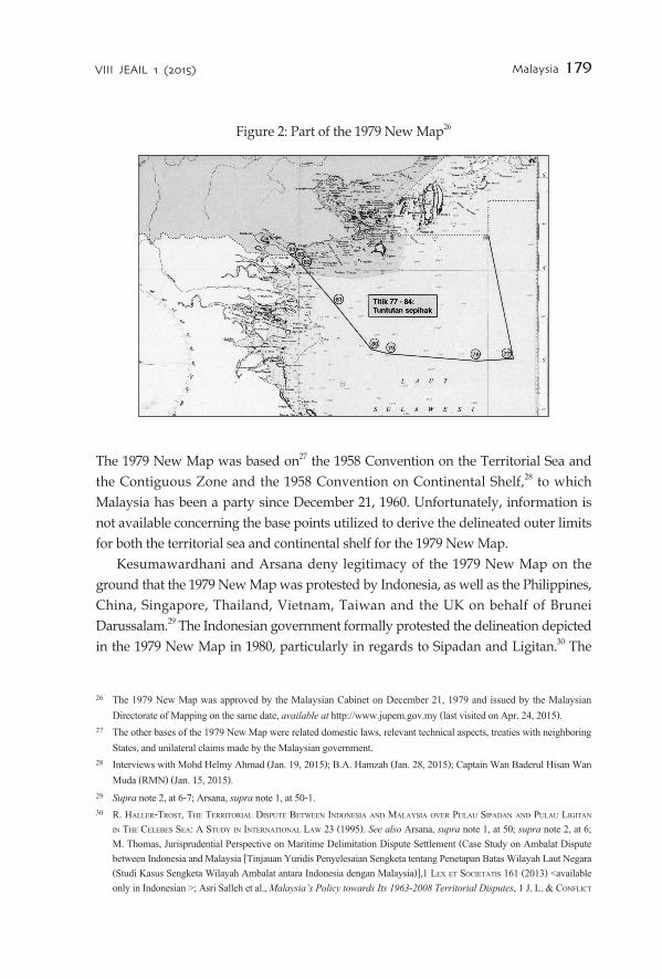
Figure 2: Part of the 1979 New Map26
The 1979 New Map was based on27 the 1958 Convention on the Territorial Sea and the Contiguous Zone and the 1958 Convention on Continental Shelf,28 to which Malaysia has been a party since December 21, 1960. Unfortunately, information is not available concerning the base points utilized to derive the delineated outer limits for both the territorial sea and continental shelf for the 1979 New Map.
Kesumawardhani and Arsana deny legitimacy of the 1979 New Map on the ground that the 1979 New Map was protested by Indonesia, as well as the Philippines, China, Singapore, Thailand, Vietnam, Taiwan and the UK on behalf of Brunei Darussalam.29 The Indonesian government formally protested the delineation depicted in the 1979 New Map in 1980, particularly in regards to Sipadan and Ligitan.30 The
26 The 1979 New Map was approved by the Malaysian Cabinet on December 21, 1979 and issued by the Malaysian Directorate of Mapping on the same date, available at http://www.jupem.gov.my (last visited on Apr. 24, 2015).
27 The other bases of the 1979 New Map were related domestic laws, relevant technical aspects, treaties with neighboring States, and unilateral claims made by the Malaysian government.
28 Interviews with Mohd Helmy Ahmad (Jan. 19, 2015); B.A. Hamzah (Jan. 28, 2015); Captain Wan Baderul Hisan Wan Muda (RMN) (Jan. 15, 2015).
29 Supra note 2, at 6-7; Arsana, supra note 1, at 50-1. 30 r. haller-trost, the territorial disPute Between indonesia and malaYsia over Pulau siPadan and Pulau liGitan
in the celeBes sea: a studY in international law 23 (1995). See also Arsana, supra note 1, at 50; supra note 2, at 6; M. Thomas, Jurisprudential Perspective on Maritime Delimitation Dispute Settlement (Case Study on Ambalat Dispute between Indonesia and Malaysia [Tinjauan Yuridis Penyelesaian Sengketa tentang Penetapan Batas Wilayah Laut Negara (Studi Kasus Sengketa Wilayah Ambalat antara Indonesia dengan Malaysia)],1 lex et societatis 161 (2013) <available only in Indonesian >; Asri Salleh et al., Malaysia’s Policy towards Its 1963-2008 Territorial Disputes, 1 J. l. & conFlict
VIII JEAIL 1 (2015) Malaysia 179

180 Torla, Yusof, & Kamal
1979 New Map is a unilateral creation marking excessive claims.31 Furthermore, Kesumawardhani argues that since the 1979 New Map has not been submitted to the UN Secretary-General pursuant to Article 47(9) of the United Nations Convention on the Law of the Sea (“UNCLOS”),32 the 1979 New Map is not legitimate.33
Indonesia did not protest the 1954 British Declaration, which included the islands of Ligitan and Sipadan as parts of North Borneo. If Indonesia had protested the 1954 British Declaration, the 1979 New Map might not have been drawn. In the absence of an Indonesian protest to the 1954 British Declaration, Malaysia redrew its continental shelf based on the 1958 Convention on Continental Shelf.
In addition, the Indonesian protest note of 1980 was regarding just the islands of Sipadan and Ligitan34 and not in any reference to any sea block. Following the ICJ decision that the two islands belong to Malaysia, Indonesia can no longer rely on the protest note of 1980 to argue against the 1979 New Map. Furthermore, since the protest note of 1980 did not contain references to any sea blocks, the Indonesian protest note of 1980 does not indicate a protest against Malaysian claims with respect to the ND6 and ND7 sea blocks.
C. Basis of the Dispute: Resource Rights
The dispute between Malaysia and Indonesia in the Celebes Sea is not a case of a dispute over sovereignty, but over sovereign rights to explore and exploit natural resources.
1. Oil ConcessionsAlongside historical evidence, Indonesia asserts sovereign rights over the Ambalat and East Ambalat sea blocks because of evidence of oil concessions. Malaysia and Indonesia began to grant oil prospecting licenses in waters off the east coast of Borneo in the 1960s.35 Indonesia claims that Malaysia recognized and respected
resol. 108 (2009); supra note 8, at 83; Mohamad Rodzi et al., Reconciliation of Malaysia-Indonesia Relationship in the South East Asia Regional Context, [Rekonsiliasi Hubungan Malaysia-Indonesia dalam Konteks Regionalisme Asia Tenggara],40 Jebat: malaYsian J. historY, Pol. & strateGY 183-4 (2013). <available only in Malay>
31 Arsana, supra note 1, at 50-1; supra note 2, at 6-7. 32 Malaysia has been a party to the UNCLOS since October 14, 1996 and Indonesia, since February 3, 1986. See
Chronological lists of ratifications of, accessions and successions to the UNCLOS and related agreements, available at http://www.un.org/Depts/los (last visited on Apr. 25, 2015).
33 Supra note 2, at 7. 34 Supra note 2, at 6-7; Arsana, supra note 1, at 50-1. 35 Supra note 10, ¶ 31.

Malaysia 181VIII JEAIL 1 (2015)
the 4°10′ N latitude parallel as forming the separation line between the respective maritime zones of both countries. Indonesia argues that recognition of such a line is evident from the granting of oil concession by Malaysia to Teiseki in 1968, where the southern limit of the concession virtually coincides with that parallel.36 Indonesia maintains that she acted in similar fashion when granting a concession to Japex/Total up to the 4°10′ N line. The limits, however, did not actually coincide with the line, but were fixed at 30” to either side of the aforementioned parallel. It is apparent from the limits of the oil concessions granted that both parties37 were merely taking precautions not to encroach into the ‘grey area’ where competing claims existed. Hence, it cannot be said that there was acquiescence on the part of Malaysia in regards to the 4°10′ N line representing a maritime boundary.
2. The 2005 DisputeThe dispute over the sea blocks flared up on February 16, 2005 when Petronas, a Malaysian State-owned oil company, granted an oil exploration concession to Shell, a British-Dutch multinational petroleum company, in the same areas where Indonesia claimed to have awarded oil concessions to the ENI and Unocal oil companies in 1999 and 2004, respectively. Subsequently, Malaysia sent protest notes on the encroachment by Indonesia into the disputed areas.38 Indonesia also claimed to have sent protests against Malaysia, but the latter denied receiving any official protest notes on the issue.39 Malaysia insisted that the concession awards were made on the basis that the areas were within Malaysian territory.
D. General Observation Regarding the Historical Evidence
If the Indonesian claim over the Ambalat and East Ambalat sea blocks is based solely on the 1891 Convention as Kesumawardhani explains, the Indonesian evidence is not strong. The ICJ determined that the 1891 Convention could not be interpreted as establishing an allocation line determining sovereignty over the islands of Borneo
36 Id. ¶ 78. 37 Id. ¶ 79. 38 Malaysia Sends Protest Note over Indon Naval Ship Intrusion, the sun dailY, Mar. 7, 2005, available at http://www.
thesundaily.com.my (last visited on Apr. 25, 2015). 39 Dharmender Singh, Ambalat Issue: No Official Protest from Indonesia, the star online, June 15, 2009, available at
http://www.thestar.com.my/story/?file=%2F2009%2F6%2F15%2Fnation%2F20090615195209&sec=nation; Areas in Sulawesi within Malaysia’s Border, the star, Mar. 2, 2005, available at http://www.thestar.com.my/Story/?file=%2F2005%2F3%2F3%2Fnation%2F10314851&sec=nat (all last visited on Apr. 25, 2015).

182 Torla, Yusof, & Kamal
and Sebatik out to sea, to the east of Sebatik Island.40 The Court also held that, when read as a whole the 1915 Agreement indicated that the 4°10′ N parallel mentioned in the 1891 Convention terminated on the east coast of Sebatik Island and did not extend seawards.41
Another relevant piece of historical evidence is the 1954 British Declaration, which included the islands of Sipadan and Ligitan as parts of North Borneo. It was not protested by Indonesia. The 1954 British Declaration preceded the 1979 New Map in which Malaysia asserted sovereign rights over the ND6 and ND7 sea blocks. If Indonesia had protested the 1954 British Declaration, the 1979 New Map might not have been drawn the way it was. Furthermore, the Indonesian protest note of 1980 against the 1979 New Map was in relation to the islands of Sipadan and Ligitan; it did not indicate a protest against Malaysian claims with respect to the ND6 and ND7 sea blocks.
Finally, the southern limit of an oil concession granted by Malaysia coincided with the 4°10′ N parallel does not indicate that Malaysia acquiesced to the parallel forming a maritime boundary. The limit was simply the result of caution being exercised by Malaysia in relation to the disputed maritime territory.
3. Maritime Boundaries and the Dispute between Indonesia and Malaysia
The establishment of the location of the baselines of a coastal State is a necessary “prerequisite in defining the limits of its zones of maritime jurisdiction” as it is an essential to “determine the points from which the specified breadth of such zones are measured.”42 The determination of baselines will “fix the outer edge of the State’s internal waters” and accordingly allow the “mechanical determination of the outer edge” of each of the maritime zones including the territorial sea, the exclusive economic zone (“EEZ”) and the continental shelf.43
40 Supra note 10. 41 Id. 42 S. Bateman & C. Schofield, State Practice Regarding Straight Baselines in East Asia –Legal, Technical and Political
Issues in Changing Environment, Difficulties in Implementing the Provisions of UNCLOS Proc., Monaco, Oct. 16-17, 2008, available at http://www.gmat.unsw.edu.au/ABLOS08Folder/Session7-Paper 1-Bateman.pdf (last visited on Apr. 25, 2015).
43 E. Jamine, Maritime Boundaries Delimitation, Management and Dispute Resolution: Delimitation of The Mozambique Maritime Boundaries with Neighbouring States (including The Extended Continental Shelf) and The Management if

A. Baselines
The UNCLOS provides the rules for drawing baseline in Articles 5 and 7. Article 5 stipulates that the normal baseline of a coastal State is “the low-water line44 along the coast as marked on large-scale charts officially recognized by the coastal State.”45 Under Article 7(1), only a State which has a “coastline deeply indented and cut into” or which has a fringe of islands along its coast in its immediate vicinity can draw straight baselines.46 The concept of straight baselines was first legitimized in 1951 in the Anglo-Norwegian Fisheries case47 and later codified and developed in the 1958 Convention on the Territorial Sea and the Contiguous Zone.48
At present, Malaysian baselines are governed by the Baselines of Maritime Zone Act of 2006 and the Territorial Sea Act of 2012. Section 5(1) of the 2006 Act provides that the baselines for the purpose of determining the maritime zones of Malaysia can be established according to “the low-water line along the coast as marked on large-scale charts; the seaward low-water line of a reef as shown by the appropriate symbol on charts; or the low-water line on a low-tide elevation that is situated wholly or partly at a distance not exceeding the breadth of the territorial sea from the mainland or an island.” However, sub-section (2) further provides that the method of straight baselines interpreted as “geodesics joining the consecutive geographical coordinates of base points so declared” may be employed for determining the maritime zones of Malaysia. Therefore, despite the provision for the general application of normal baselines, straight baselines may be utilized if deemed necessary. Considering the geographic nature of the coast of Sabah, the method of straight baselines is employed.
The Malaysian baseline illustrated in the 1979 Map has been subject to numerous protests and disagreements by neighboring States. Kesumawardhani argues against the use of straight baselines in the 1979 New Map on the grounds that Malaysia is not an archipelagic State. Only such States are entitled to use straight baselines in
Ocean Issues 14 (2007), available at http://www.un.org/depts/los/nippon/unnff_programme_home/fellows_pages/fellows_papers/jamine_0607_mozambique.pdf (last visited on Feb. 21, 2015).
44 The low water line is defined as the “intersection of the plane of low water with the shore. The line along the coast, or beach, to which the sea recedes at low water.” See un oFFice For ocean aFFairs and the law oF the sea, Baselines: an examination oF the relevant Provisions oF the united nations convention on the law oF the sea 58 (1989).
45 Convention on the Territorial Sea and Contiguous Zone, art. 3. 46 Id. art. 4(1). 47 Anglo-Norwegian Fisheries (U.K. v. Nor.), Judgment, 1951 I.C.J. 116 (Dec. 18). 48 Of the four conventions that were concluded following the First United Nations Conference on the Law of the Sea in
1958, the Convention on the Territorial Sea and the Contiguous Zone is of direct relevance to baselines.
VIII JEAIL 1 (2015) Malaysia 183

accordance with Article 47 of the UNCLOS.49
The 1979 New Map was not the first one Malaysia utilized ‘straight baselines.’ It has been mentioned above that the 1954 British Declaration, the 1969 Continental Shelf Boundary Agreement, and the 1971 Territorial Sea Agreement also employed straight lines with the acquiescence or consent from the Indonesian government.
Drawing straight baselines is the practice of most coastal States in East Asia. They include China,50 Japan,51 South Korea,52 Vietnam53 and Brunei Darussalam,54 the latter of which is located between Sabah and Sarawak. Sabah is located between Indonesia and the Philippines, which opted to use straight archipelagic baselines in 1960 and 1961, respectively.55 The use of straight baselines in the 1979 New Map was a means by which Malaysia could place itself on an equal footing with Indonesia and the Philippines. Otherwise, Malaysia would be in a disadvantageous position. It should also be noted that the drawing of the 1979 New Map took into consideration relevant islands and other maritime features of Malaysia, Indonesia and the Philippines.56
While Kesumawardhani argues that the 1979 New Map is not legitimate on the ground that it has not been submitted to the UN Secretary General pursuant to Article 47(9) of the UNCLOS,57 Malaysia does not claim to be an archipelagic State.
49 Supra note 2, at 14. 50 The People's Republic of China declared straight baselines along parts of its coast on May 15, 1996. See Hyunsoo Kim,
China’s Basepoints and Baselines under the United Nations Convention on the Law of the Sea: A Critical Analysis, 6. J. east asia & int’l l. 138 & 140 (2013).
51 Japan utilized straight baselines in the Law to Partially Amend the Law on the Territorial Sea (Law No. 73 of 1996), which entered into force on July 20, 1996.
52 South Korea utilized straight baselines in the 1977 Territorial Sea and Contiguous Zone Act, Law No. 4986 (amended in 1995).
53 The Socialist Republic of Vietnam claimed straight baselines in the Statement on the Territorial Sea, the Contiguous Zone, the Exclusive Economic Zone, and the Continental Shelf of Vietnam, which was declared on May 12, 1977. For details, see Hong Thao Nguyen, Vietnam’s Position on the Sovereignty over the Paracels & Spratlys: Its Maritime Claims, 5. J. east asia & int’l l. 196 (2012).
54 Territorial Waters Enactment, 1982 of Brunei Darussalam appears to enable the establishment of straight baselines. 55 Indonesia first utilized straight archipelagic baselines in Article 1(2) of the Act concerning Indonesian Waters (Act No.
4), which was declared on February 18, 1960. The current baselines are established by Government Regulation 38 of 2002 (modified by Government Regulation No 37 of 2008). Meanwhile, the Philippines also utilized straight baselines in Act to Define the Baselines of the Territorial Sea of the Philippines (Republic Act No. 3046), which was enacted on June 17, 1961 (amended on Sept. 18, 1968 by Republic Act 5446). For details on the domestic legislation of the Philippines, see L. Bautista, The Philippine Claim to Bajo de Masinloc in the Context of the South China Sea Dispute, 6, J. east asia & int’l L. 505 (2013).
56 Interviews with Mohd Helmy Ahmad (Jan. 19, 2015) and Captain Wan Baderul Hisan Wan Muda (RMN), (Jan. 15, 2015).
57 Supra note 32.
184 Torla, Yusof, & Kamal

VIII JEAIL 1 (2015) Malaysia 185
Furthermore, non-observation of Article 47(9) does not render a map illegitimate. Similarly, non-observation of Article 16(2) by a coastal State will not render its map illegitimate, either. Nevertheless, it is advisable for Malaysia to deposit a copy of its list of geographical co-ordinates with the UN Secretary-General.
B. Maritime Boundary Delimitation
Under the UNCLOS, the guiding principles on the delimitation of boundaries in overlapping EEZ and continental shelf claims are set out in Articles 74(1) and 83(1), respectively. They stipulate that boundaries are to be delimited by agreement on the basis of international law in order to reach an equitable solution. No predominance is given to any one method of delimitation under the aforementioned provisions. What remain as the guiding principle is that the end result of a maritime delimitation agreement must be equitable.
The applicable principle is therefore left to both Malaysia and Indonesia to decide. What is important is that the principle invoked should provide an equitable result for both parties. Based on the current jurisprudence, developed through the decisions of the courts and tribunals, the unified consensus on the method of maritime boundary delimitation involves drawing a provisional equidistance line during the initial stages of negotiation, which can be either preserved or adjusted later based upon the existence of relevant circumstances in the disputed area.58
In the present case, the final point of the land border in Sebatik Island (4°10′ N latitude) should become the initial point of the maritime border. The principal issue concerns identifying the starting point of maritime boundary from the end point of the land boundary in Sebatik Island, i.e., whether the boundary should be a straight line parallel to the 4°10′ N line as claimed by Indonesia; or be drawn south ward as depicted by the Malaysian government in the 1979 New Map. While Arsana shares the same view concerning the final point of the land border in Sebatik Island as the initial point of the maritime border, the authors would further clarify that that the argument should not be construed as indicating that the maritime border should be a straight line following 4°10′ N latitude because the maritime border must be
58 See, e.g., Territorial and Maritime Dispute (Nicar. v. Colom.), Judgment, 2012, I.C.J. 624 (Nov. 19), available at http://www.icj-cij.org/docket/index.php?p1=3&p2=3&case=124; Dispute concerning Delimitation of the Maritime Boundary between Bangladesh and Myanmar in the Bay of Bengal (Bangl. v. Myan.), Judgment, 2012, I.T.L.O.S. (Mar. 14), available at https://www.itlos.org/cases/list-of-cases/case-no-16; Territorial and Maritime Dispute between Nicaragua and Honduras in the Caribbean Sea (Nicar. v. Hond.), Judgment, 2007, I.C.J. 659 (Oct. 8), available at http://www.icj-cij.org/docket/?p1=3&p2=3&code=nh&case=120&k=14; Arbitration between Guyana and Suriname (Guy. v. Surin.), Award, 2007, Arbitral Tribunal (Sept. 17), available at http://www.pca-cpa.org/showpage.asp?pag_id=1147 (all last visited on Apr. 25, 2015).

drawn in such a manner as to divide the maritime area of the Celebes Sea justly.59
As far as the ND6 and ND7 sea blocks are concerned, the negotiation between both States is still on-going.60 No agreement has, as of yet, been reached regarding how the overlapping claims should be resolved. The latest negotiation meeting was held on October 26, 2013 in Malaysia.61 Unfortunately, the detailed report of the negotiation is not publicized as of March 2015. Since it was a scheduled negotiation, which inevitably included various issues other than the unresolved boundary dispute, it is expected to take more time before a final agreement can be reached.
1. Sipadan and Ligitan Award as a Basis for Claim Before the ICJ decided on the Pulau Ligitan and Pulau Sipadan case, which favored the Malaysian position, both islands had been used by Indonesia as base points. Since Indonesia applies the archipelagic baseline system, the effect of drawing baselines using the two islands was that the Ambalat and East Ambalat sea blocks fell within the internal waters of Indonesia. The Indonesian government has reconfigured its base points and baselines since the decision. As of 2009, Indonesian base points reflected that the islands of Sipadan and Ligitan are part of Malaysia,62 considering that these islands were no longer used as base points by Indonesia. As a result, the Ambalat and East Ambalat sea blocks are no longer within the internal waters of Indonesia, but fall within Indonesian EEZ and continental shelf zones.
Conversely, following the decision by the ICJ in the Pulau Ligitan and Pulau Sipadan case, Malaysia may now use both islands as a basis for the claim of sovereign rights over ND6 and ND7. As an island, in the sense of Article 121 of the UNCLOS, Sipadan is able to legitimately claim maritime zones, including territorial seas, EEZ and continental shelf.
In the Bangladesh v. Myanmar judgment,63 the International Tribunal for the Law of the Sea (“ITLOS”) clearly distinguished the effect of islands on the delimitation of territorial seas from that of islands on the delimitation of the EEZ and continental shelf. The Tribunal decided to give full effect to St. Martin’s Island in the delimitation of the territorial sea, while rejecting the argument put forward by the Myanmar government that the equidistant line between the Myanmar mainland and St. Martin’s Island should be adjusted closer to St. Martin’s Island due to the size of the
59 Arsana, supra note 1, at 53. 60 Interview with Mr. Mohd Helmy Ahmad (Jan. 19, 2015). 61 Id. 62 Government Regulation of the Republic of Indonesia No. 37 (2008). 63 Maritime Boundary between Bangladesh and Myanmar, supra note 58.
186 Torla, Yusof, & Kamal

island and the geographic location of St. Martin’s Island, which is in close proximity to the Myanmar mainland.64
In that case, Bangladeshi sovereignty over St. Martin’s Island and maritime territory located off the coast of Myanmar was given full effect by the ITLOS. The Tribunal acknowledged that less than full effect was usually given to islands which were “insignificant maritime features.”65 The ITLOS cited the example of Qit’at Jaradah in the case of Qatar v. Bahrain, which was “a very small island, uninhabited and without any vegetation.”66 In comparison, St. Martin’s Island is 8 square kilometres in size and has a population of about 7,000 people.67 Since St. Martin’s Island is an island pursuant to Article 121(1) of the UNCLOS, however the Tribunal accorded it a 12 nautical miles (nm) territorial sea. It can be deduced from this case that the sovereignty attached to the territorial sea was much more fundamental to the integrity of a State as a whole than the rights exercised in the EEZ and continental shelf zone. Thus, an island is entitled to a territorial sea even when the island had been ignored or given partial effect in the delimitation of the EEZ and continental shelf.
If applying the approach of the ITLOS in the Bangladesh/Myanmar case to the present case, Sipadan generates a territorial sea extending 12 nm from its baselines. This would place ND6 within the territorial sea. Nonetheless, Indonesia may assert that the area overlaps with the territorial sea generated from Karang Unarang, the new base point adopted. Accordingly, the next issue to be considered is whether Karang Unarang should be ignored for the purpose of delimitation of the territorial sea, which would result in the ND6 sea block being located within the territorial sea of Sipadan without any overlap of the territorial sea of Indonesia and wholly falling within the territory of Malaysia.
2. Karang Unarang as a New Base Point for IndonesiaFollowing the Ligitan and Sipadan case, Indonesia chose to use Karang (Batuan) Unarang, located at 04°00’38”N 118°04’58”E,68 as a new base point for baseline
64 Id. ¶ 152. 65 Id. ¶ 151. 66 Id. See also Case concerning Maritime Delimitation and Territorial Questions between Qatar and Bahrain (Qatar v.
Bahr.), Judgment, 2001 I.C.J. 40, ¶ 219 (Mar. 16), available at http://www.icj-cij.org/docket/index.php?sum=441&p1=3&p2=3&case=87&p3=5 (last visited on May 7, 2015).
67 Id. ¶ 143. 68 See A list of the geographical coordinates of the points utilized for the Indonesian archipelagic baselines based on the
Government Regulation of the Republic of Indonesia No. 38 (2002) and as amended by the Government Regulation of the Republic of Indonesia No. 37 (2008), available at http://www.un.org/depts/los/LEGISLATIONANDTREATIES/
VIII JEAIL 1 (2015) Malaysia 187

188 Torla, Yusof, & Kamal
calculations. Since this feature is only visible during low tide, it is submitted that this feature is a mere rocky mass or a low-tide elevation at most 30 cm during low tide, it is incapable of sustaining human habitation in the sense of Article 121 of the UNCLOS. The revised Indonesian baseline is drawn from Sebatik Island (base point No. TD.036B) to Charring Unarang (TD.037) for 12.22nm; and from Karang Unarang to Maratua Island (TD.039) for 110.27nm.
Figure 3: The Amended Baselines of Indonesia69
�
Figure 3 shows the amended baselines of Indonesia following the Pulau Ligitan and Pulau Sipadan case. Karang Unarang is located slightly within the ND6 block, as shown in Figure 4. The use of Karang Unarang is an important element of the Indonesian claim over the Ambalat and East Ambalat sea blocks because the EEZ and continental shelf zones generated from Karang Unarang overlap with the EEZ and continental shelf zones generated from the island of Sipadan.
PDFFILES/DEPOSIT/idn_mzn67_2009.pdf (last visited on Apr. 25, 2015).69 Id.

Figure 4: The Territorial Sea generated from Karang Unarang and Sipadan
As such, the customary equidistance principle should be invoked to delimit the area. According to the UNCLOS, a low-tide elevation can be used as a base point.70 However, when applying the equidistance principle, Karang Unarang should arguably be ignored for the purpose of delimiting the maritime boundary for the following reasons. First, the size of Karang Unarang is considerably smaller than the island of Sipadan. The former is a mere rock or low-tide elevation incapable of sustaining human habitation and economic life. At the low water line, the highest the rock could reach is a mere 30cm during the low tide. In the case of Qatar/Bahrain, the ICJ disregarded low-tide elevations as the ground of drawing the equidistant line. Second, the ND6 sea block was plotted by Malaysia based on the 1979 New Map and years prior to the amendment of the Indonesian baselines in 2009. Thereby, the sea block was known to Indonesia, which should have consulted Malaysia prior to the amendment of the Indonesian baselines utilizing Karang Unarang as a base point. Third, in any case, Sipadan, as an island, is entitled to a 12 nm territorial sea as established in the Bangladesh/Myanmar judgment.71 In comparison, Karang Unarang, an insignificant maritime feature, would be accorded less than full effect as laid down in Qatar/Bahrain72 and Bangladesh/Myanmar.
70 UNCLOS art. 13. 71 Maritime Boundary between Bangladesh and Myanmar, supra note 58. 72 Maritime Delimitation and Territorial Questions between Qatar and Bahrain, supra note 66.
VIII JEAIL 1 (2015) Malaysia 189

Maritime Delimitation in the Black Sea between Romania and Ukraine case73 concerned the delimitation of the continental shelf and the EEZ by a single maritime boundary between Romania and Ukraine in the northwestern part of the Black Sea. One of the issues relevant to the delimitation was the presence of Serpents’ Island,74 which was part of the territory of Ukraine. Serpents’ Island is located 20nm from the Danube delta between the two States; it is merely 0.17 square kilometers at high tide with a circumference of 2,000 meters.75 The ICJ held that Serpents’ Island should be disregarded in the drawing of the provisional equidistant line due to the considerable distance between the island and the mainland coast.76 To that end, the Court stated that utilizing the island as a base point in drawing the equidistant line would constitute a “refashioning of geography.”77 In addition to the massive distance between the island and the mainland coast, another reason can be implied from the decision of the ICJas it has been noted that the Court may have disregarded the island as a base point due to its small size.78 Comparing the situation concerning Serpents’ Island to the present case, Karang Unarang is also significantly smaller in size than Serpents’ Island since it is a low-tide elevation which only reaches 30 cm. The size and nature of Karang Unarang are valid reasons to disregard the feature when drawing the equidistant line.
Comparing Karang Unarang to Sipadan, the latter is an island in the sense of the UNCLOS. Thus, it is submitted that Karang Unarang should be ignored for the purpose of delimiting the maritime boundary. Consequently, the territorial sea of Indonesia would be generated from the outermost point of the Indonesian mainland, as illustrated in Figure 5 below.
73 Case Concerning Maritime Delimitation in the Black Sea (Rom. v. Ukr.), Judgment, 2009 I.C.J. 61 (Feb. 3), available at http://www.icj-cij.org/docket/index.php?p1=3&p2=2&PHPSESSID=fcccb763fd140d1d3dadd47cbb59ee2b&case=132&code=ru&p3=4 (last visited on May 7, 2015).
74 Id. ¶ 14. 75 Id. ¶ 16. 76 Id. ¶ 149. 77 Id. 78 A. Elferink, Maritime Delimitation in the Black Sea (Romania v Ukraine): A Commentary, The Hague Justice Portal
(2009), available at http://www.haguejusticeportal.net/Docs/Commentaries%20PDF/Oude%20Elferink%20-%20Black%20Sea.pdf (last visited on May 7, 2015).
190 Torla, Yusof, & Kamal

Figure 5: Territorial Sea generated from Indonesia’s outermost point on mainland Borneo ignoring Karang Unarang as a base point
Figure 5 demonstrates that ignoring Karang Unarang and using the outermost point on the east coast of the Kalimantan mainland as a base point would result in an equidistant line that is consistent with the line drawn in the 1979 New Map of Malaysia. Therefore, it can be deduced that the 1979 New Map was drawn following the equidistance principle and correctly ignores the tiny low-tide elevation known as Karang Unarang. Hence, the ND6 sea block is wholly situated within Malaysian territory, with no overlapping claim able to be asserted by Indonesia.
3. Ligitan Island and ND7Another noticeable point concerns the island of Ligitan, which was also recognized as being a sovereign possession of Malaysia. Ligitan is an island lying 21 nm from mainland Borneo that is permanently above sea level; with low-lying vegetation, trees, and mainly sand.79 Looking at the description of Ligitan and applying the cases previously mentioned in regards to the island of Sipadan, Ligitan would also constitute an island in the sense of Article 121 of the UNCLOS. As a result, maritime zones are also generated from the island of Ligitan.
The geographical description of the area, as illustrated in Figure 6, provides no indication of any maritime features belonging to Indonesia south and southeast of
79 Supra note 10, ¶13.
VIII JEAIL 1 (2015) Malaysia 191

192 Torla, Yusof, & Kamal
the island of Ligitan except for Pulau Maratua, which lies 113 nm south of Ligitan. It is worthy to note that the ND7 sea block claimed by Malaysia is also located south of Ligitan. Figure 6 shows the 200 nm limit generated from the island of Ligitan (Malaysia) and the 200nm limit generated from Maratua Island (Indonesia). An apparent overlap exists between the continental shelf generated from the two respective islands, and the ND7 sea block falling within the Indonesian continental shelf zone. After applying the equidistance principle, however, the equidistant line would determine a boundary that is more or less consistent with the 1979 New Map of Malaysia. The result of drawing the equidistant line is that the whole or at least large portion of the ND7 sea block, falls within Malaysian maritime territory.
Figure 6: The Line in Orange shows the 200 nm limit of Ligitan, while the Green Line shows the 200 nm of Maratua Island
From the observation made above, it is emphasized that Malaysia has sovereign rights over the ND6 and ND7 sea blocks as depicted in the 1979 New Map based on the following two important findings. First, the status of Sipadan and Ligitan as islands under the UNCLOS would place the sea blocks within Malaysian waters. Second, after applying the equidistance principle, the equidistant line would also place the ND6 and ND7 sea blocks within Malaysian territory after Karang Unarang is disregarded as a base point.
ORANGE
GREEN

Malaysia 193VIII JEAIL 1 (2015)
4. Conclusion
The historical evidence put forward on behalf of Indonesia is not conclusive. Indonesia once attempted to argue, albeit unsuccessfully, that the 1891 Convention provided a basis for territorial claims over the islands of Ligitan and Sipadan. Reliance on the same Convention to claim the Ambalat and East Ambalat sea blocks will likely be unsuccessful, either. The 1891 Convention did not consider islands and the maritime territory east of Sebatik Island and Borneo. This is also supported by the subsequent 1915 Agreement.
If Indonesia had protested the 1954 British Declaration, Malaysia might have negotiated with Indonesia before drawing the 1979 New Map. The Indonesian protest note of 1980 against the 1979 New Map did not indicate a protest against Malaysian claims with respect to the ND6 and ND7 sea blocks.
Straight baselines in the 1979 New Map were legitimately drawn under international law. Indonesia had acquiesced to the employment by Malaysia of straight baselines in the 1954 British Declaration, the 1969 Continental Shelf Boundary Agreement, and the 1971 Territorial Sea Agreement. In addition to Malaysia, other East Asian States also employ straight baseline systems. Thus, the 1979 New Map correctly depicts both the ND6 and ND7 sea blocks as being within the Malaysian waters.
Alongside the 1979 New Map, the application of the customary equidistance principle also results in a similar finding. As a legal consequence of the decision by the ICJ in the Pulau Ligitan and Pulau Sipadan case, Malaysia may now use both islands as a basis to assert sovereign rights over the ND6 and ND7 sea blocks. Even if the 1979 New Map is ignored, applying the equidistance principle to delimit the maritime boundary would also result in a maritime boundary similar to the 1979 New Map. However, the tiny low-tide elevation known as Karang Unarang should not be utilized by Indonesia as a base point based upon existing decisions of international judicial bodies. As a consequence, the ND6 sea block will be wholly situated within Malaysian waters, having no overlapping claim. Indonesia is not entitled to it. Similarly, an equidistant line drawn taking into account the island of Ligitan (Malaysia) and the Maratua Island (Indonesia) would place most, if not all, of the ND7 sea block within Malaysian maritime territory.


