
The Development of Online Disaster Information System ...
12
Institute of Advanced Engineering and Science w w w . i a e s j o u r n a l . c o m International Journal of Informatics and Communication Technology (IJ-ICT) Vol.3, No.1, February 2014, pp. 47~58 ISSN: 2252-8776 47 Journal homepage: http://iaesjournal.com/online/index.php/IJICT The Development of Online Disaster Information System Using Location Based Service (LBS) Technology Nasaruddin *,** , YudhaNurdin ** , Roslidar ** *Master of Electrical Engineering Programme, Syiah Kuala University ** Departement of Electrical Engineering, Syiah Kuala University Article Info ABSTRACT Article history: Received Jan 12 th , 2013 Revised Jul 25 th , 2013 Accepted Nov 28 th , 2013 Indonesia is geographically located in the disaster vulnerable area and frequently hit by various disasters such as earthquake, flood, etc. So that Indonesian people aware that the disaster information system is very crucial. Thus, the development of information and communication technology application is needed for disaster management. For this purpose, this paper proposes on the development of online disaster information system based on location based service (LBS) technology by using short message service (SMS) gateway and global positioning system (GPS). Then, the web-based prototype of online disaster information system is designed and developed as the media to provide information of location and situation of the disaster area. Furthermore, a user interface is also designed and developed to transmit input data as the location information using manual SMS and automatically using smartphone based on SMS/GPS. The research method used in this research is a spiral method that begins with conceptual design, prototype development, application test, and evaluation. The results of this research are the web-based information system and the implemented user interface application for Android smartphone (we called it ASIKonLBS). The online mapping of input data from smartphone to the web-based system has been tested. It shows that the disaster location information can be mapped to Google Maps timely and accurately that can be accessed using the Internet connection. The evaluation to mapping delay time shows that it is lower than the refresh time of the web-based system. Therefore, the proposed online system can be categorized as a real-time system. Keyword: ASIKonLBS Online system Disaster SMS gateway GPS Copyright © 2014 Institute of Advanced Engineering and Science. All rights reserved. Corresponding Author: Nasaruddin, Master of Electrical Engineering Programme, Syiah Kuala University, Jln. Syech Abdurrauf, Darussalam, Banda Aceh 23111, Indonesia. Email: [email protected] 1. INTRODUCTION Nowadays, the planning and development of information and communication technology (ICT) in disaster management are mainly focused on the government disaster agencies and donor institutions sides without involving public and community. On the other hand, almost all members of society have used ICT devices in their daily activities such as smartphone, tablet, etc. This fact has motivated the development of ICT application for disaster that applying new method of communicating, coordinating, and sharing information among the disaster victim, society, and the formal disaster agencies. A prompt disaster management is one of the challenges in disaster management including quick response, evacuation plan, and logistic distribution in saving humanity from natural hazards [1]. In fact that the number of disaster agency staffs is very limited during the disaster so that it is not enough in giving assistant to the victims. To solve
Transcript of The Development of Online Disaster Information System ...

Institute of Advanced Engineering and Science
w w w . i a e s j o u r n a l . c o m
International Journal of Informatics and Communication Technology (IJ-ICT)
Vol.3, No.1, February 2014, pp. 47~58
ISSN: 2252-8776 47
Journal homepage: http://iaesjournal.com/online/index.php/IJICT
The Development of Online Disaster Information System Using
Location Based Service (LBS) Technology
Nasaruddin*,**
, YudhaNurdin**
, Roslidar**
*Master of Electrical Engineering Programme, Syiah Kuala University
** Departement of Electrical Engineering, Syiah Kuala University
Article Info ABSTRACT
Article history:
Received Jan 12th
, 2013
Revised Jul 25th
, 2013
Accepted Nov 28th
, 2013
Indonesia is geographically located in the disaster vulnerable area and
frequently hit by various disasters such as earthquake, flood, etc. So that
Indonesian people aware that the disaster information system is very crucial.
Thus, the development of information and communication technology
application is needed for disaster management. For this purpose, this paper
proposes on the development of online disaster information system based on
location based service (LBS) technology by using short message service
(SMS) gateway and global positioning system (GPS). Then, the web-based
prototype of online disaster information system is designed and developed as
the media to provide information of location and situation of the disaster
area. Furthermore, a user interface is also designed and developed to transmit
input data as the location information using manual SMS and automatically
using smartphone based on SMS/GPS. The research method used in this
research is a spiral method that begins with conceptual design, prototype
development, application test, and evaluation. The results of this research are
the web-based information system and the implemented user interface
application for Android smartphone (we called it ASIKonLBS). The online
mapping of input data from smartphone to the web-based system has been
tested. It shows that the disaster location information can be mapped to
Google Maps timely and accurately that can be accessed using the Internet
connection. The evaluation to mapping delay time shows that it is lower than
the refresh time of the web-based system. Therefore, the proposed online
system can be categorized as a real-time system.
Keyword:
ASIKonLBS
Online system
Disaster
SMS gateway
GPS
Copyright © 2014 Institute of Advanced Engineering and Science.
All rights reserved.
Corresponding Author:
Nasaruddin,
Master of Electrical Engineering Programme,
Syiah Kuala University,
Jln. Syech Abdurrauf, Darussalam, Banda Aceh 23111, Indonesia.
Email: [email protected]
1. INTRODUCTION
Nowadays, the planning and development of information and communication technology (ICT) in
disaster management are mainly focused on the government disaster agencies and donor institutions sides
without involving public and community. On the other hand, almost all members of society have used ICT
devices in their daily activities such as smartphone, tablet, etc. This fact has motivated the development of
ICT application for disaster that applying new method of communicating, coordinating, and sharing
information among the disaster victim, society, and the formal disaster agencies. A prompt disaster
management is one of the challenges in disaster management including quick response, evacuation plan, and
logistic distribution in saving humanity from natural hazards [1]. In fact that the number of disaster agency
staffs is very limited during the disaster so that it is not enough in giving assistant to the victims. To solve

ISSN:2252-8776
IJ-ICT Vol. 3, No. 1, February 2014 : 47 – 58
48
this problem, the role of community is needed as well as the ICT support to facilitate the communication in
community using smartphone. Smartphone has been equipped with many sophisticated features such as high
resolution camera, GPS, video, sensor, and longlife battery to accommodate these features. Smartphone has
also been connected to the internet to enable web accessing, data collecting, and information sharing among
the involved component in disaster management. These features are provided in a timely and efficiently
disaster management application.
The most important information when disaster hit an area is the location coordinate. Thus, the
implementation of LBS technology is very crucial in building and developing the innovative ICT for disaster
management as it provides feature and service based on location (geolocation) [2]. Supporting by wireless
communication technology that provided a timely mobile communication with many features and services,
LBS technology has two approaches [3]. First, the location data is processed on a server and the result is sent
to mobile equipment. Second, location data is determined for an application based on the mobile equipment
to be used directly. It will be very useful to overcome the disaster, where the information of the location is a
key factor in disaster management.
During the emergency response and post-disaster, some problems arise such as slow aid, uneven logistic
distribution, not enough volunteers, uninformed location for donors, critical displacement, and demanding
coordination among the disaster management agencies because of lack information about location and
situation of the disaster. This problem arises as the information about location is not available online during
the disaster and post-disaster. Disaster information system for the pre-disaster stage is available, for example
the information system of disaster risk management in [4, 5]. During the response stage, some of disaster
emergency management applications have been introduced in [6-9]. However, all of the applications have to
be supported by robust infrastructure of information and communication network that make it difficult to be
implemented in Indonesia. Another information system that has been available during the rehabilitation and
reconstruction is SAHANA [10]. Based on the fact mentioned above, the location and situation information
of the disaster is needed to be delivered to disaster agencies and community using an easy, quick and
accurate access. Therefore, this paper proposes the development of online disaster information system based
on LBS technology.
In this research, LBS technology is applied based on the availability of Short Message Service (SMS) and
Global Positioning System (GPS) on the smartphone [6, 11-13]. SMS and GPS services are very effective
and economic to be reconstructed after the disaster. Moreover, there are so many users of cellular phone that
will be increased in amount and will spread to remote villages. Thus, the SMS gateway and mobile GPS [14]
will be simply to be implemented in the proposed smartphone application to help transmitting textual and
spatial information to online web-based system. Sending information to the system can be done anywhere
and anytime by the registered member (authorized user). The received information from the smartphone
application (we called it web ASIKonLBS) will be saved in database and forwarded on online application by
mapping it to Google Maps service on the web system. Hopefully, ASIKonLBS application and web-based
system will give benefits in analyzing and responding the disaster to help community and government
dealing with the circumstances after the disaster especially in making quick response to assist the disaster
victims.
2. RESEARCH METHOD
The research method applied here is a spiral method as shown in Figure 1. In the system application
development, there are four stages which are concept development, application design, building and testing,
and evaluation.
Concept Design
DevelopmentEvaluation
Final Version of Application
Starting PointUser Interface Design
Testing and Evaluation Application Prototype
Application Development

IJ-ICT ISSN: 2252-8776
The Development of Online Disaster Information System Using Location Based Service (Nasaruddin)
49
Figure 1. Research method
Start
Error Message
Input Data
Online Information System Standby
Member
Database
Message Format Verification
Online Disaster Map/Location
End
Yes
Yes
No
No
Figure 2. Flowchart of the application development
Based on the spiral method, the initial step is developing the online disaster information application
concept where the disaster agency, society, and the victim at the location are able to send information by the
proposed user interface to the developed web-based system. The design is started by designing the input data
that will be sent manually using mobile phone by informing the coordinate of the disaster location or using
smartphone by automating the GPS on a user interface. On the second step, to enable the information
transmission, a user interface is designed based on LBS technology for several platforms of smartphone
facilitated with GPS that is called ASIKonLBS. After designing the ASIKonLBS, the prototype of the web-
based application is built following the steps shown in Figure 2. The message sent by ASIKonLBS will be
validated based on the member status of the web-based system. If the message is sent by the member, then
the information is saved in the database inbox of the system server. Then, the system will check the format of
the input data about the disaster location sent by the application. If the format is compatible, then the
information will be mapped to the online website system using Google Maps to enable the information to be
accessed through the internet.
3. DESIGN OF APPLICATION
3.1. The Concept of Application System
The concept of online disaster information system can be seen in Figure 3. The application is started with
identification of the disaster location such as fire, flood, landslide, etc. It follows by the information sent by
the community at the disaster location using cellular phone facilitated with GPS to track the coordinate of the
location. The information that is compatible with the format of ASIKonLBS application will be send to
global system for mobile communications (GSM) network through base transceiver station (BTS) which is
then forwarded to global system for mobile communications center (GSMC). Using SMS gateway, the
information is transferred to the web system server. This information is stored in the database server of the
system and will be disseminated to the user via web-based system and the map of Google Maps. The users
(disaster agency staffs) who are outside the disaster location can access the web-based system to find out the
situation especially the location of the disaster.

ISSN:2252-8776
IJ-ICT Vol. 3, No. 1, February 2014 : 47 – 58
50
Figure 3. Conceptual model of online disaster information system
Transmitting information of the disaster location for ASIKonLBS is restricted to the member that has
been registered to the application. The expected member that has to register to the web-based system is the
staff from disaster bureaus such as Search and Rescue (SAR), Indonesian Red Cross (PMI), hospitals, and
disaster management practioners. The purpose is to avoid fake information coming to the ASIKonLBS
system. The main focus is how to verify the received information as fast as possible before posting it to the
system in order to approach real time information. The information of location and situation are very crucial
for the community when the disaster strike the area. This information helps in building the preparedness and
endurance of the community. The communication technology is very helpful in preparing the readiness in
facing emergency situation. ASIKonLBS can be disseminated for early information in emergency
countermeasure and mobilize aid after the disaster. The user of ASIKonLBS can access information using
website that will be designed with the main feature of information of disaster location applying Google Map
and open layers, disaster report, and the newest disaster mapped online.
3.2. User and Technical Requirements
Based on the concept of online disaster information system, as shown in Figure 3, the technical
requirement in terms of hardware and software of the system can be identified as shown in Table 1. In
accordance with some experiences of the user needs on ICT based disaster application, the following are the
general facts for the proposed system:
- Data of disaster location are provided timely and accurately - Data of disaster location are accessable by the public as soon as possible - The disaster location can be monitored by the related agencies
Table 1. Hardware and software requirements
Hardware Software
Server Web server
Modem GSM Now SMS Gateway Mobile GPS PHP
Smartphone MySQL
SIM card Apache Dreamweaver
Google Maps API
Open Layers

IJ-ICT ISSN: 2252-8776
The Development of Online Disaster Information System Using Location Based Service (Nasaruddin)
51
Table 2.Disaster code and icon [15]
Code Disaster Icon
101 Fire
102 Tsunami
103 Flood
104 Landslide
105 Earthquake
106 Drought
107 Storm
108 Tidal Wave
109 Volcanoe
Figure 4. Example of input data format to ASIKonLBS [15]
Input data to ASIKonLBS can be sent only by registered member that is already registered in the system
database to ensure that the received information is valid and from a trusted sender such as the member from
the disaster agency staffs such as Local Disaster Agency, SAR, PMI, etc. To simplify the input data
transmission, some of disaster types that have hit and have potentially hit Aceh Province are created in the
specific codes and given in icon as nationally approved. The disaster codes and icons are listed in Table 2.
The example of input data format for ASIKonLBS is described in Figure 4. This format is easy and simple to
be applied in LBS technology as smartphone has been facilitated with GPS technology. In this way, the
coordinate can be automatically retrieved by the smartphone.
The format of input data to ASIKonLBS application is determined based on the following parameters:
INFO is the keyword to send the information using LBS technology through SMS gateway. This
keyword is also used to enable the auto respons of the application by stated “Thank you, your
information will soon be processed”. If the sent format is wrong, then the system will take the
autorespons as follows “Wrong Format, Please type INFO [space] Disaster code [space] Longitude
[space] Latitude”.
Disaster code represents types of the disaster that have hit Aceh Province. These codes are listed in
Table 2. The disaster code will be published on the system website and will be socialized to the member
of the application.
Longitude (X) is the point of coordinate that specifies the east and west position of earth as depicted in
Figure 4.
Latitude (Y) is the position point of coordinate of the imagenary line used to determine the location of
the Earth’s equator, as depicted in Figure 4.

ISSN:2252-8776
IJ-ICT Vol. 3, No. 1, February 2014 : 47 – 58
52
3.3 Information and Communication Infrastructure
Figure 5. Information and communication infrastructue of online disaster information system
In implementing the online disaster information system, it is important to consider the infrastructure
of the information and communication as shown in Figure 5. This infrastructure has to be supported by the
cellular communication network as described in Figure 3. If the network conection is not available during the
disaster, then victims, community and disaster officials at the area can send the information using the
proposed user interface via satellite network. Furthermore, the internet connection is needed in transmitting
the information to the online information system that implemented at the local disaster and goverment
agencies. Internet connection is part of the social communication and media in giving the access of
information to the community efficiently. Local disaster management agencies as the main responsible
parties will give first response in providing aid to the victim. However, with the limited staffs at the agencies,
community support is needed to assist the victim. Furthermore, aid from outside disaster area is very
significant to minimize the total victim and damage caused by the disaster. Hence, all components at the
disaster area can share information about the location and situation to the disaster management agencies and
government. The community, victims, and staffs of disaster management agencies at the disaster location are
able to send information in text message following the designed format using the proposed application of
smartphone with LBS technology. During the emergency situation, textual information can be sent through
satellite and wireless communication network even though the BTS at the area is down. Then the information
is sent to the online disaster information system as the information dessemination mediator to the parties
outside the disaster area using internet connection.
3.4. User interface for application
A user interface has been designed using phonegap with prototype design as shown in Figure 6.
Currently, the prototype have been developed using Android Development Tool (ADT) and consist of 2
languages; Indonesian and English. In the prototype, user can send the information about disaster type, event
time, longitude and latitude. The information that sent via SMS than received by the web-based system and
shared to public via Internet. ASIKonLBS is developed to help the smartphone users sending information
about the disaster that occurs around them. As it can be seen from the prototype that it guides the user to
fulfill required information to enable it to be sent via SMS. Furthermore, ASIKonLBS can take geospatial
information automatically by taking the coordinate information from smartphone GPS. The dropdown
features gave the user to choose what kind of disaster type that occurs. Finally, the information then sent
through SMS by using a phone number that is provided by application. Figure 7 shows a screenshot of
information sent through SMS using a smartphone-based Android.
INTERNET
DISASTER
OFFICIALS
DISASTER
VICTIMS
COMMUNITY
Online
Information
System
Local Disaster Agencies
+
NGO
Government
Agencies
DISASTER AREA

IJ-ICT ISSN: 2252-8776
The Development of Online Disaster Information System Using Location Based Service (Nasaruddin)
53
Figure 6. Design of prototype for user interface
Figure 7. Main menu of the implemented ASIKonLBS based on Android

ISSN:2252-8776
IJ-ICT Vol. 3, No. 1, February 2014 : 47 – 58
54
Figure 8. Features of ASIKonLBS based on Android
In the current state, the application that been build is using Android Development Tool (ADT) that only
works for Android platform smartphone. For the future user interface, we will use phonegap framework
because it can be applied to the multi platform of smartphone without using the different programming
languages. In the phonegap, the programming is in HTML5, CSS3 and Javascript. By using phonegap build,
the application is bundled by phonegap builder into the application with different smartphone platform. The
bundle at the phonegap supports any smartphone type such as iOS Apple, Android, Windows Mobile,
Symbian, BlackBerry, WebOS LG andBada (OS on Samsung). User interface with the data input format for
ASIKonLBS to enable sending information to the web application as shown in Figures 6-8. Currently, this
application has been implemented based on Android as displayed in Figure 7. It is designed as simple as
possible so that the information can be sent as soon as possible when disaster occurs. To obtain, the location
of user or disaster, the application uses the GPS sensor to find its location automatically. The implemented
application has been evaluated as presented in Table 3, where the parameters work properly in the testing of
the application features as shown in Figure 8. The two types of the prototype that been build are ASIKonLBS
in Bahasa Indonesia and ASIKonLBS in English.
Table 3. ASIKonLBS evaluation
No EvaluationParameters Remarks Result
1 Main menu display Able to display disaster type, GPS
coordinate and send SMS
Success
2 Disaster type Able to display disaster type that
should be selected for reporting to
the web-based application
It has successfully be
mapped to the google maps
on the web application with
appropriate icon of the
disaster type
3 Coordinate GPS sensor has ability to detect
and find the location coordinate
automatically
Valid
4 Send SMS Send SMS menu is able to send the
information to the web-based
application successfully
Success
IJ-ICT ISSN: 2252-8776
The Development of Online Disaster Information System Using Location Based Service (Nasaruddin)
55
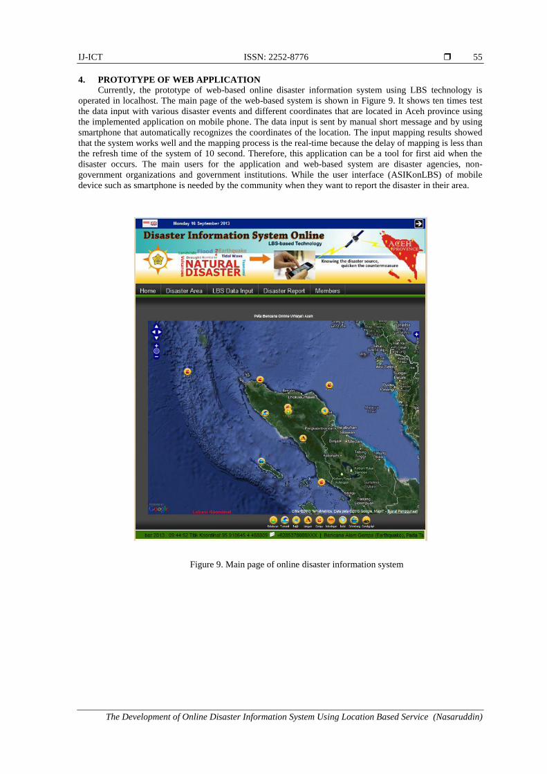
4. PROTOTYPE OF WEB APPLICATION
Currently, the prototype of web-based online disaster information system using LBS technology is
operated in localhost. The main page of the web-based system is shown in Figure 9. It shows ten times test
the data input with various disaster events and different coordinates that are located in Aceh province using
the implemented application on mobile phone. The data input is sent by manual short message and by using
smartphone that automatically recognizes the coordinates of the location. The input mapping results showed
that the system works well and the mapping process is the real-time because the delay of mapping is less than
the refresh time of the system of 10 second. Therefore, this application can be a tool for first aid when the
disaster occurs. The main users for the application and web-based system are disaster agencies, non-
government organizations and government institutions. While the user interface (ASIKonLBS) of mobile
device such as smartphone is needed by the community when they want to report the disaster in their area.
Figure 9. Main page of online disaster information system

ISSN:2252-8776
IJ-ICT Vol. 3, No. 1, February 2014 : 47 – 58
56
Figure 10. Location and type of disaster information on web application
Table 4. Delay of online mapping into web application
Disaster
Code Longitude Latitude
Transmit
Time
Receive
Time
Mapping Delay
(second)
102 95.910645 4.488809 09.44.50 09.44.59 9
104 97.207031 3.634036 09.49.42 09.49.52 10
108 95.789795 2.855263 09.54.05 09.54.12 7
103 97.943115 4.565474 09.59.49 09.59.56 7
105 96.687000 4.698000 10.22.17 10.22.25 8
105 93.257953 5.913881 11.38.45 11.38.54 9
105 98.097954 5.443883 11.53.34 11.53.42 8
105 95.737954 5.643883 11.56.28 11.56.36 8
105 97.827954 2.143883 12.01.05 12.01.15 10
101 96.697951 4.543884 12.05.02 12.05.09 7
Average delay 8.3 s
Besides the online information mapping that sent by the member of system, textual information related
to the disaster report can be displayed at the web of system by clicking the icon of the disaster on the web.
Then, the tooltip will appear as shown in Figure 10, where this tool tip shows the information of disaster
type, sender identity, and coordinate of disaster area in terms of its longitude and latitude. Thus, disaster
agencies can check the validation of information and situation at the area. Furthermore, google street maps
are also available on the web that can be used to retrieve the location easily. This feature will be usefulfor the
decision maker; here is the government, to give a quick response on the disaster aid.
The effectiveness of online mapping from user interface ASIKonLBS to the web-based system can be
evaluated by measuring the delay time of transmit time and receive time. Online mapping time has been

IJ-ICT ISSN: 2252-8776
The Development of Online Disaster Information System Using Location Based Service (Nasaruddin)
57
evaluated by ten deliveries via sms manual and through implemented application-based smartphone with
various coordinates and types of disaster. The detail of disaster type, coordinate, transmit time and receive
time can be seen in the Table 4. The mapping delay are counted and analyzed to find the performance of the
web-based system. The delay here is the time required by the information from sender to be mapped on the
web application as a recipient. The results showed that the average delay of information delivery through a
user's applications and time of location mapping to the web system was 8.3 second. The average delay is still
below refresh time of system by 10 second, so the proposed online disaster information system can be
categorized as a real-time information system.
5. CONCLUSION
This paper has described the design and development of online disaster information system based on
LBS technology where it consists of user interface application (ASIKonLBS) and web-based system for
online mapping of the disaster location on Google map. ASIKonLBS is an application where the information
of disaster location with the specific input data format can be detected automatically using GPS sensor on
smartphone and then sent to the web-based system via SMS gateway and wireless network. While the web-
based system is a system that provides the information of the disaster event on the web, especially the
disaster location and map. The web-based system is needed by the people who are located outside of the
disaster area and has responsibility to help the victim quickly such as local disaster agencies and government.
In this research, ASIKonLBS has been designed with a simple input data format and has been implemented
on the real application for Android based smartphone. Furthermore, the web-based system prototype has also
been designed and implemented on the localhost that can be connected to internet for online mapping of the
disaster information from ASIKonLBS. Both ASIKonLBS and web-based system have been evaluated in
which the results showed that the user application and web system can be operated properly. The web-based
system is timely proceeded and mapped the received information from ASIKonLBS on the Google Maps.
Moreover, the online mapping delay has been analyzed by sending ten location coordinates with various
disaster types on ASIKonLBS. The result showed that the average delay time is lower than the refresh time
of the web-based system. Therefore, the proposed system can be categorized as a real-time information
system. Considering the phenomenon and the frequency of the disaster hit Indonesia especially Aceh, this
application and web-based systemare very useful for emergency response and reconstruction stage.
ACKNOWLEDGEMENTS
This paper is part of research that is funded by Hibah Penelitian Strategis Nasional (Stranas), Indonesian
Directorate General of Higher Eduction (DIKTI), in the 2013-2014.
REFERENCES [1] Nasaruddin, Munadi K, Dirhamsyah M, Yuliansyah D. A Web-based Geographical Information System for Aceh
Natural Hazards. Telkomnika. 2011. 9(1); 89-98.
[2] Open Geospatial Consortium (OGC). GeoSMS Standard for Emergency and Disaster Management.
[3] Kupper A. Location-based Services: Fundamentals and Operation. John Wiley & Sons Ltd: Chichester, West
Sussex. 2005.
[4] Nasaruddin, Munadi K, Dirhamsyah M. Design of Disaster Risk Management Information System in Aceh
Province. Proc. of 5th AIWEST-DR 2010. Banda Aceh. 2010.
[5] Nasaruddin. Interactive Map-based Information System for Disaster Risk Reduction in Aceh. Proc. 6th AIWEST
2011-SCSTW4. 2011.
[6] Aloudat A, Michael K, Yan J. Location-Based Services in Emergency Management from Government to Citizens:
Global Case Studies. Research online. 2007. 1-8.
[7] Meissner A, Wang Z. MIKoBOS – A Mobile Information and Communication System for Emergency Response.
Proc. of 3rd International ISCRAM Conference. USA. 2006.
[8] Ma Y, Kalashnikov V, Haiharan R, Mehrotra S, Venkatasubramanian N, Ashish N, Lickfett J. On-Demand
Information Portals for Disaster Situations. Proc. of IEEE ISI. 2007.
[9] Jo MH, Jo YW, Shin DH. Advanced Real-time Disaster Information Mapping Technique by Integrating UBGI
(Ubiquitous Geographic Information). Proc. of the International Achieves of the Photogrammetry, Remote Sensing
and spatial Information Sciences. Beijing. 2008. 37(Part B8); 463-466.
[10] Careem M, De Silva C, De Silva R, Raschid L. Sahana: Overview of Disaster Management System. Proc. of the
International conference on information and automation. Srilanka. 2006. 1-6.
[11] Chang SE, Hsieh YJ, Lee TR, Lia CK, Wang ST. A User Study on the Adoption of Location Based Services.
APWeb/WAIM Ws, LNCS 4537, Springer-Verlag: Heidelberg, Germany. 2007. 276-286.

ISSN:2252-8776
IJ-ICT Vol. 3, No. 1, February 2014 : 47 – 58
58
[12] Lohan E, Rusu-Casandra A, Cramariuc O, Marghescu I, Cramariuc B. End-User Attitudes towards Location-Based
Services and Future Mobile Wireless Devices: The Students’ Perspective. Journal of Information. 2011. 2; 426-
454.
[13] Martire F, Bartolomeo G, Trubiani C, Salsano S. Location Based Services Architecture for Simple Mobile services.
Technical Report, Information Society Tecnologies. 2008.
[14] Azyat A, Raissouni N, Acchab NB, Lahraouna M, Chahboun A. Mobile Geographic Information System Platform
(MGISP): A GPS Information Collection System. International Journal of Information and Network Security
(IJINS). 2012. 1(2); 140-151.
[15] Nasaruddin, Nurdin Y, Roslidar, Dirhamsyah M. Konseptual Desain Aplikasi Sistem Informasi Kebencanaan
Online Berbasis Teknologi LBS (ASIK on LBS). Proc. Seminar Nasional Forum Teknik Elektro Indonesia
(FORTEI). Padang. 2013.
BIBLIOGRAPHY OF AUTHORS
Nasaruddin was born in Aceh, Indonesia, on April 2, 1974. He received the B.Eng.
degree in Electrical Engineering from Sepuluh Nopember Institute of Technology,
Surabaya, Indonesia in 1997. Then he received M. Eng and D. Eng in Physical
Electronics and Informatics, Graduate School of Engineering, Osaka City University,
Japan, in 2006 and 2009, respectively. He is a lecturer at electrical Engineering
Department, Syiah Kuala University. He is also head of master of electrical engineering
programme; graduate school of Syiah Kuala University. He has published several papers
in international journals and accredited national journals. His research interests include
digital communications, information theory, optical communications and ICT
applications for disaster. He is a member of IEEE and IAES.
Yudha Nurdin was born in Bangkok, Thailand, grew up in Banda Aceh, Indonesia, and
studied electrical engineering at Bandung Institute of Technology (ITB) in Bandung,
Indonesia. After graduate, he finished his Master degree in electrical engineering at ITB
with major in Information Technology. At present, he is a lecturer and researcher at
Syiah Kuala University (UNSYIAH) in Banda Aceh, Indonesia. He has also conducted
several researches with Tsunami and Disaster Mitigation Research Center (TDMRC), a
research center that focuses on disaster mitigation. His research interests are agent-based
modeling, simulation and programming.
Roslidar was born in Banda Aceh, Indonesia, on July 19, 1978. In 2002, she received
her bachelor degree at Electrical Engineering Department of Syiah Kuala University at
the same place where then she become a lecturer. She graduated from
Telecommunication Engineering of University of Arkansas for her Master degree in
2009.


