The Crane operational catchment - Crane Valley … · The Crane operational catchment Thames River...
32
1 The Crane operational catchment Thames River Basin Management Plan consultation support pack Nov 2014 This pack is to help those with an interest in the Crane operational catchment to respond to the 2014/15 consultation on the draft updated Thames River Basin Management Plan. It should be read alongside the official consultation documents and the London catchment summary, and does not seek to duplicate the explanation or information they contain. Access the consultation online at http://www.gov.uk/government/consultations/update-to-the-draft- river-basin-management-plans Alternatively you can request a hard copy of the reports and response forms by contacting our enquiries team on 03708 506 506 or [email protected]
Transcript of The Crane operational catchment - Crane Valley … · The Crane operational catchment Thames River...

1
The Crane operational catchment Thames River Basin Management Plan consultation support pack Nov 2014
This pack is to help those with an interest in the Crane operational
catchment to respond to the 2014/15 consultation on the draft
updated Thames River Basin Management Plan.
It should be read alongside the official consultation documents and
the London catchment summary, and does not seek to duplicate
the explanation or information they contain.
Access the consultation online at
http://www.gov.uk/government/consultations/update-to-the-draft-
river-basin-management-plans
Alternatively you can request a hard copy of the reports and
response forms by contacting our enquiries team on 03708 506 506

2
3
List of Contents
Changes to water bodies – information to support consultation question 1
Cycle 1 water bodies
Cycle 2 water bodies
Proposed changes to designated uses of heavily modified and artificial
water bodies
Long-term objectives for 2021 – information to support consultation question 2
Catchment Data Explorer – information to support consultation question 3
Measures – information to support consultation questions 4 and 6
Catchment-wide measures for all water bodies
Measures for the Crane GB106039023030
Measures for the Yeading Brook GB106039023051
Measures for the Port Lane Brook GB106039023450
Measures for the Duke of Northumberland’s River at Heathrow*
GB806100108
*includes measures for the Duke of Northumberland’s River at
Twickenham and the Longford River – these rivers are not currently on
the proposed cycle 2 water body network but were included in the cost-
benefit analysis
Measures for Kempton Park East Reservoir GB30642614
Cost benefit analysis final appraisal report – information to support consultation
question 5
4
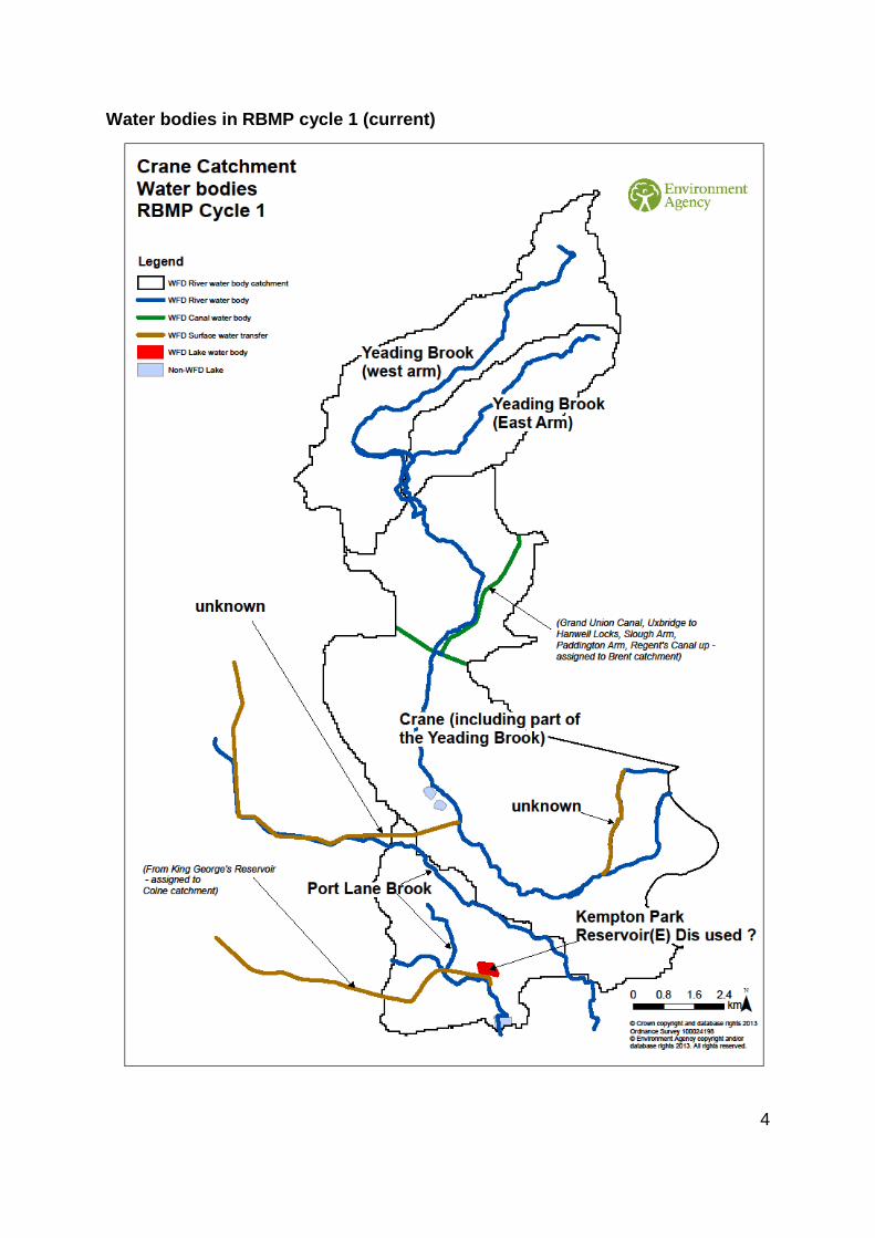
Water bodies in RBMP cycle 1 (current)
5
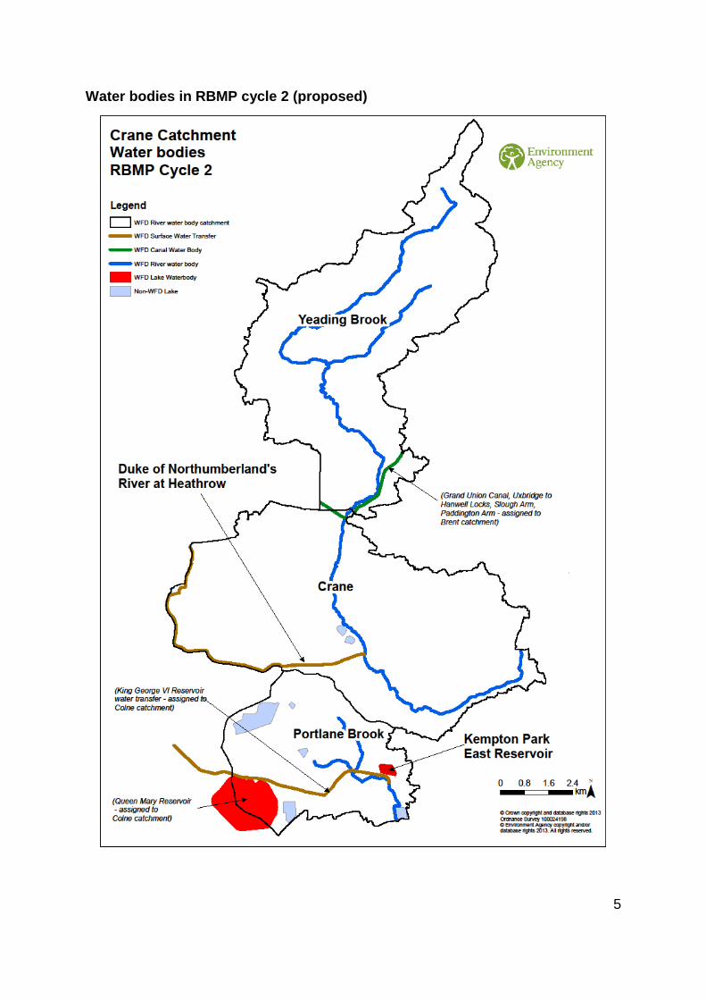
Water bodies in RBMP cycle 2 (proposed)

6
Long-term objectives for 2021
We are proposing long term objectives of good ecological status by 2021 for the Crane water
body, and good ecological potential by 2021 for the other water bodies.

7
Catchment Data Explorer
Information about the status of water bodies in the Crane operational catchment can be found
doing a classification search on Catchment Data Explorer at
http://environment.data.gov.uk/catchment-planning/OperationalCatchment/senet79/ .
8
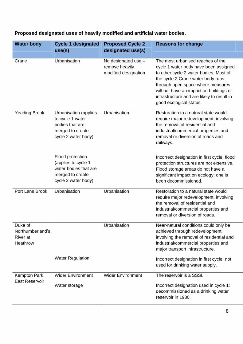
Proposed designated uses of heavily modified and artificial water bodies.
Water body Cycle 1 designated
use(s)
Proposed Cycle 2
designated use(s)
Reasons for change
Crane Urbanisation No designated use –
remove heavily
modified designation
The most urbanised reaches of the
cycle 1 water body have been assigned
to other cycle 2 water bodies. Most of
the cycle 2 Crane water body runs
through open space where measures
will not have an impact on buildings or
infrastructure and are likely to result in
good ecological status.
Yeading Brook
Urbanisation (applies
to cycle 1 water
bodies that are
merged to create
cycle 2 water body)
Flood protection
(applies to cycle 1
water bodies that are
merged to create
cycle 2 water body)
Urbanisation Restoration to a natural state would
require major redevelopment, involving
the removal of residential and
industrial/commercial properties and
removal or diversion of roads and
railways.
Incorrect designation in first cycle: flood
protection structures are not extensive.
Flood storage areas do not have a
significant impact on ecology; one is
been decommissioned.
Port Lane Brook Urbanisation Urbanisation Restoration to a natural state would
require major redevelopment, involving
the removal of residential and
industrial/commercial properties and
removal or diversion of roads.
Duke of
Northumberland’s
River at
Heathrow
Water Regulation
Urbanisation Near-natural conditions could only be
achieved through redevelopment
involving the removal of residential and
industrial/commercial properties and
major transport infrastructure.
Incorrect designation in first cycle: not
used for drinking water supply.
Kempton Park
East Reservoir
Wider Environment
Water storage
Wider Environment
The reservoir is a SSSI.
Incorrect designation used in cycle 1:
decommissioned as a drinking water
reservoir in 1980.
9
Measures
Measures are on 4 different scales:
Catchment-wide measures (listed on the next page) – applicable to all water bodies in the
Crane catchment.
Water body wide measures (listed for each water body) – applicable throughout the water
body and/or its catchment area.
Reach measures (mapped for each water body) – measures for specific lengths of river.
Note that the colours used are to distinguish neighbouring or overlapping measures and
have no other significance.
Point measures (mapped for each water body) – measures for specific locations centred
on a single point represented by a dot on the map.

10
Catchment-wide measures – measures for all water bodies in the
Crane catchment
2041 Only Rain in Rivers - Be a Solution to Water Pollution' pollution awareness campaign
throughout the Crane catchment to raise awareness and elicit behaviour change about
misconnections, blockages, and other sources of domestic pollution.
2282 Ongoing, co-ordinated programme for the control and management of Himalayan
Balsam in a catchment-wide strategy as a contribution to national Invasive Species Action
Plan
2283 Slow the spread of high impact invasive non-native species by adopting good
biosecurity practice and by promoting campaigns such as, “Check, Clean, Dry” and “Be
Plantwise” to local stakeholders who take part in water sports, boating, angling and other
activities in or near water.
2286 Continue to improve knowledge of species distributions and improve public
awareness of new and established Invasive Non-native Species through co-ordinated
catchment-wide monitoring, surveys and mapping.
2572 Ongoing, co-ordinated programme for the control and management of giant hogweed
in a catchment-wide strategy as a contribution to national Invasive Species Action Plan.
2575 Ongoing, co-ordinated programme for the control and management of Japanese
knotweed in a catchment-wide strategy as a contribution to national Invasive Species
Action Plan.
2589 Promote Local Action Groups in the Crane catchment to engage the support of the
third sector in controlling invasive non-native species and in promoting key messages.
11
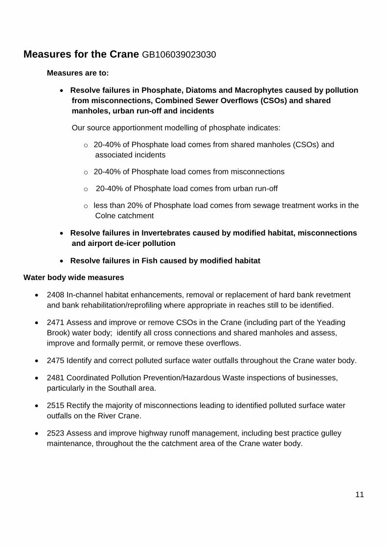
Measures for the Crane GB106039023030
Measures are to:
Resolve failures in Phosphate, Diatoms and Macrophytes caused by pollution
from misconnections, Combined Sewer Overflows (CSOs) and shared
manholes, urban run-off and incidents
Our source apportionment modelling of phosphate indicates:
o 20-40% of Phosphate load comes from shared manholes (CSOs) and
associated incidents
o 20-40% of Phosphate load comes from misconnections
o 20-40% of Phosphate load comes from urban run-off
o less than 20% of Phosphate load comes from sewage treatment works in the
Colne catchment
Resolve failures in Invertebrates caused by modified habitat, misconnections
and airport de-icer pollution
Resolve failures in Fish caused by modified habitat
Water body wide measures
2408 In-channel habitat enhancements, removal or replacement of hard bank revetment
and bank rehabilitation/reprofiling where appropriate in reaches still to be identified.
2471 Assess and improve or remove CSOs in the Crane (including part of the Yeading
Brook) water body; identify all cross connections and shared manholes and assess,
improve and formally permit, or remove these overflows.
2475 Identify and correct polluted surface water outfalls throughout the Crane water body.
2481 Coordinated Pollution Prevention/Hazardous Waste inspections of businesses,
particularly in the Southall area.
2515 Rectify the majority of misconnections leading to identified polluted surface water
outfalls on the River Crane.
2523 Assess and improve highway runoff management, including best practice gulley
maintenance, throughout the the catchment area of the Crane water body.

12

13
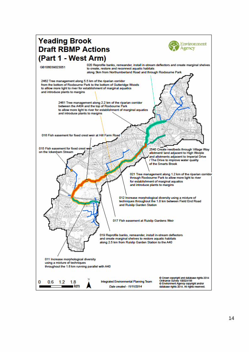
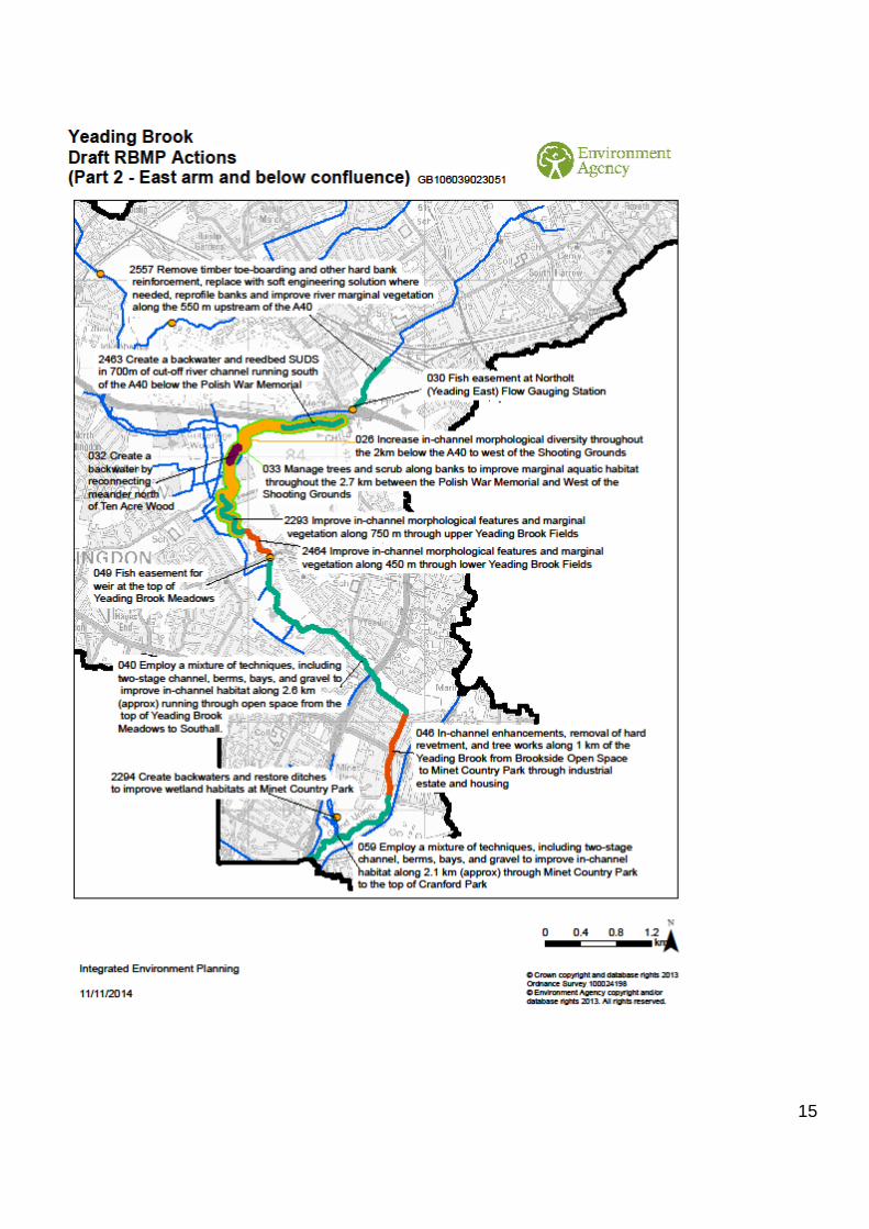
Measures for the Yeading Brook GB106039023051
Measures are to:
Put mitigation measures in place
Resolve failures in Invertebrates caused by pollution from misconnections and
urban run-off
Water body wide measures
Note: water body wide measures were identified for the two separate cycle 1 water bodies which
we are now proposing to combine in cycle 2. We propose that otherwise identical actions listed
below for both cycle 1 water bodies should be combined into single actions for the cycle 2 water
body.
008 Educate riparian landowners along whole watercourse on sensitive management in
response to changes to vegetation, hydrology and sediment supply as a result of
urbanisation.
009 Enhance channel bed within all railway and road culverts downstream of the A404.
023 Educate riparian landowners along whole watercourse on sensitive management in
response to changes to vegetation, hydrology and sediment supply as a result of
urbanisation.
024 Enhance channel bed within all railway and road culverts downstream of Victoria Retail
Park.
2473 Identify and correct polluted surface water outfalls throughout the Yeading Brook
West water body.
2474 Identify and correct polluted surface water outfalls throughout the Yeading Brook East
water body.
2516 Rectify the majority of misconnections leading to identified polluted surface water
outfalls on the Yeading Brook East.
2517 Rectify the majority of misconnections leading to identified polluted surface water
outfalls on the Yeading Brook West.
2524 Assess and improve highway runoff management, including best practice gulley
maintenance, throughout the the catchment area of the Yeading Brook East water body.
2525 Assess and improve highway runoff management, including best practice gulley
maintenance, throughout the the catchment area of the Yeading Brook West water body.
14
15
16
Measures for the Port Lane Brook GB106039023450
Measures are to:
Put mitigation measures in place
Resolve failures in Phosphate and Invertebrates caused by pollution from
misconnections and urban run-off; and in Phosphate caused by Combined
Sewer Overflows (CSOs) and industry
Our source apportionment modelling of phosphate indicates:
o Urban run-off and misconnections are a major source of the Phosphate
load
o Combined Sewer Overflows (CSOs) and shared manholes are a minor
source of the Phosphate load
o Industry is a minor source of the Phosphate load
Water body wide measures
2316 Enhance marginal and in-channel habitats wherever possible along the Port Lane
Brook and Felthamhill Brook.
2476 Identify and correct polluted surface water outfalls throughout the Port Lane Brook
water body.
2480 Co-ordinated Pollution Prevention/Hazardous Waste inspections of businesses,
particularly in the Bedfont and Hanworth areas.
2518 Rectify the majority of misconnections leading to identified polluted surface water
outfalls on the Port Lane Brook.
2526 Assess and improve highway runoff management, including best practice gulley
maintenance, throughout the the catchment area of the Port Lane Brook water body.
17
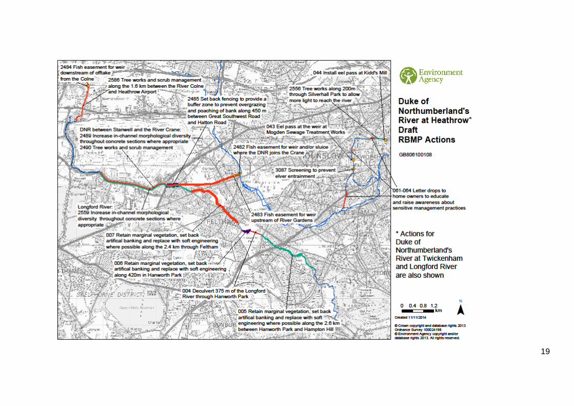
Measures for the Duke of Northumberland’s River at Heathrow GB806100108
Measures are to:
Put mitigation measures in place
Water body wide measures
2486 Educate riparian landowners along whole watercourse on sensitive management in
response to changes to vegetation, hydrology and sediment supply as a result of
urbanisation.
2487 Enhance channel bed within the six road culverts (total length 284m) passing beneath
the major roads around the perimeter of Heathrow Airport.
2488 Remove timber toe-boarding and realign/reprofile banks in appropriate locations still
to be identified.
Measures for the Duke of Northumberland’s River at Twickenham
Note: this water body is not currently proposed as a cycle 2 water body, but actions have been
identified for it as part of the cost benefit analysis and are listed here.
Measures are to:
Put mitigation measures in place
Water body wide measures
2571 Ongoing, co-ordinated programme for the control and management of Floating
pennywort (Hydrocotyle ranunculoides) on the Duke of Northumberland’s River as a
contribution to the national Invasive Species Action Plan.
307 Remove toe-boarding and realign/reprofile banks in appropriate locations still to be
identified.
308 Retain and enhance the vegetation within the river channel and riparian zones.
312 Educate riparian landowners along whole watercourse on sensitive management in
response to changes to vegetation, hydrology and sediment supply as a result of
urbanisation.

18
Measures for the Longford River
Note: this water body is not currently proposed as a cycle 2 water body, but actions have been
identified for it as part of the cost benefit analysis and are listed here.
Measures are to:
Put mitigation measures in place
Water body wide measure
2558 Enhance channel bed within the four road culverts (total length 250m) passing
beneath the major roads around the perimeter of Heathrow Airport.
19
20
Measures for Kempton Park East Reservoir GB306426140
Measures have not been identified for this water body, as we consider it to be at good ecological
potential.
21
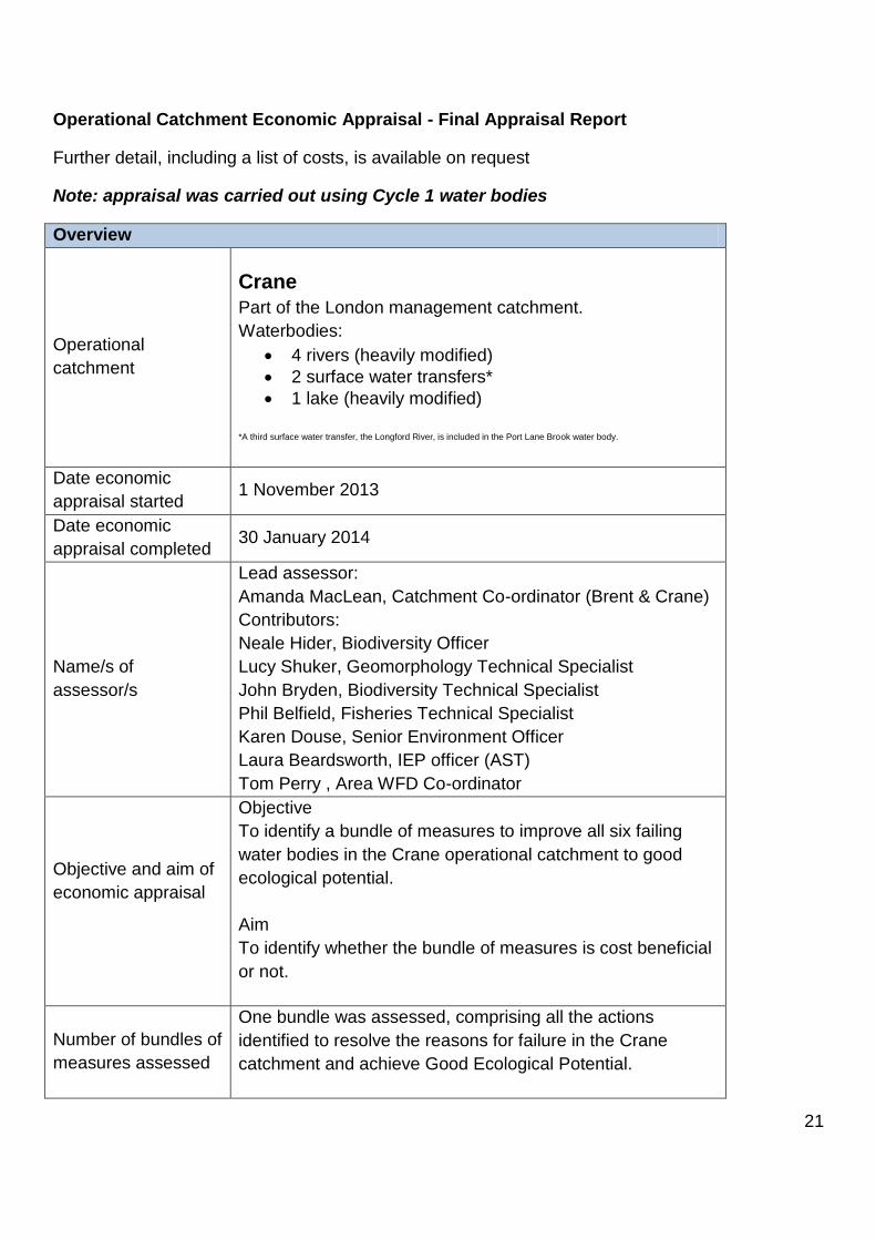
Operational Catchment Economic Appraisal - Final Appraisal Report
Further detail, including a list of costs, is available on request
Note: appraisal was carried out using Cycle 1 water bodies
Overview
Operational
catchment
Crane
Part of the London management catchment.
Waterbodies:
4 rivers (heavily modified)
2 surface water transfers*
1 lake (heavily modified) *A third surface water transfer, the Longford River, is included in the Port Lane Brook water body.
Date economic
appraisal started 1 November 2013
Date economic
appraisal completed 30 January 2014
Name/s of
assessor/s
Lead assessor:
Amanda MacLean, Catchment Co-ordinator (Brent & Crane)
Contributors:
Neale Hider, Biodiversity Officer
Lucy Shuker, Geomorphology Technical Specialist
John Bryden, Biodiversity Technical Specialist
Phil Belfield, Fisheries Technical Specialist
Karen Douse, Senior Environment Officer
Laura Beardsworth, IEP officer (AST)
Tom Perry , Area WFD Co-ordinator
Objective and aim of
economic appraisal
Objective
To identify a bundle of measures to improve all six failing
water bodies in the Crane operational catchment to good
ecological potential.
Aim
To identify whether the bundle of measures is cost beneficial
or not.
Number of bundles of
measures assessed
One bundle was assessed, comprising all the actions
identified to resolve the reasons for failure in the Crane
catchment and achieve Good Ecological Potential.
22
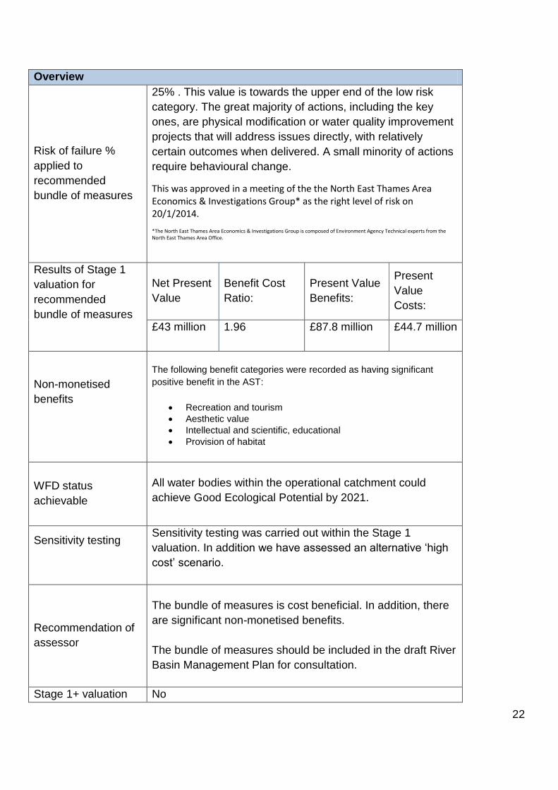
Overview
Risk of failure %
applied to
recommended
bundle of measures
25% . This value is towards the upper end of the low risk
category. The great majority of actions, including the key
ones, are physical modification or water quality improvement
projects that will address issues directly, with relatively
certain outcomes when delivered. A small minority of actions
require behavioural change.
This was approved in a meeting of the the North East Thames Area Economics & Investigations Group* as the right level of risk on 20/1/2014.
*The North East Thames Area Economics & Investigations Group is composed of Environment Agency Technical experts from the North East Thames Area Office.
Results of Stage 1
valuation for
recommended
bundle of measures
Net Present
Value
Benefit Cost
Ratio:
Present Value
Benefits:
Present
Value
Costs:
£43 million 1.96 £87.8 million £44.7 million
Non-monetised
benefits
The following benefit categories were recorded as having significant
positive benefit in the AST:
Recreation and tourism
Aesthetic value
Intellectual and scientific, educational
Provision of habitat
WFD status
achievable
All water bodies within the operational catchment could
achieve Good Ecological Potential by 2021.
Sensitivity testing
Sensitivity testing was carried out within the Stage 1
valuation. In addition we have assessed an alternative ‘high
cost’ scenario.
Recommendation of
assessor
The bundle of measures is cost beneficial. In addition, there
are significant non-monetised benefits.
The bundle of measures should be included in the draft River
Basin Management Plan for consultation.
Stage 1+ valuation No

23
Overview
required?
WAG section 5
QA undertaken
An informal QA was undertaken by NE area staff in January
2014, however no formal QA has been completed.
Detail
Bundle/s of measures
The main types of measures included in the bundle are to deliver three of the seven key
objectives in The Crane Valley - a Water Framework Directive Catchment Plan produced by the
Crane Valley Partnership:
1. River rich and diverse in habitats and native wildlife - creating and enhancing wetland habitats throughout the river corridor; reducing shading of the river channel; an ongoing, catchment wide programme for the control and management of Giant hogweed, Japanese knotweed, Himalayan balsam and floating pennywort
2. Clean, clear water- reducing pollution from diffuse and point sources (primarily sewer overflows, domestic pollution, and urban drainage)
3. A natural looking and functioning river with sustainable flow- removing or modifying man-made structures; improving connectivity by removing or bypassing barriers to fish passage; improved water level management; realignment and reprofiling
Relevant actions from the Crane Catchment Plan are incorporated alongside others identified by
Environment Agency staff.
Measures which address no deterioration were removed from the cost benefit analysis of the
bundle of measures (as per guidance) before economic appraisal was carried out. The benefits
and effects on the wider environment are recorded in the Appraisal Summary Table.
Measures have been chosen primarily to address the impacts of significant water management
issues causing failures under the Water Framework Directive. Where possible, climate resilient
measures have been chosen. However it is considered unlikely that the measures will be
sufficient to address all impacts of climate change and we will be assessing the likely gaps before
the publication of the final River Basin Management Plans.
Reference: Measures, Bundles and Costs sheet (see below)
Costs
Costs used
Total costs for the Crane cost benefit analysis for CAPEX (Capital
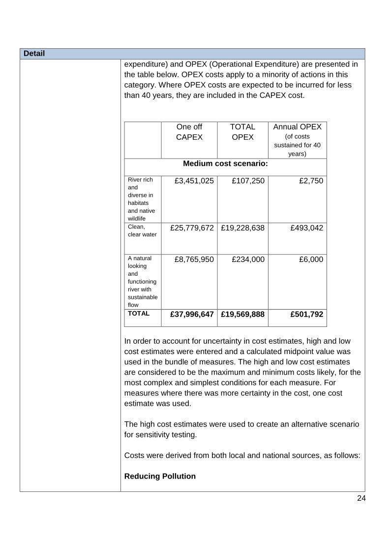
24
Detail
expenditure) and OPEX (Operational Expenditure) are presented in
the table below. OPEX costs apply to a minority of actions in this
category. Where OPEX costs are expected to be incurred for less
than 40 years, they are included in the CAPEX cost.
One off
CAPEX
TOTAL
OPEX
Annual OPEX (of costs
sustained for 40
years)
Medium cost scenario:
River rich
and
diverse in
habitats
and native
wildlife
£3,451,025 £107,250 £2,750
Clean,
clear water
£25,779,672 £19,228,638 £493,042
A natural
looking
and
functioning
river with
sustainable
flow
£8,765,950 £234,000 £6,000
TOTAL £37,996,647 £19,569,888 £501,792
In order to account for uncertainty in cost estimates, high and low
cost estimates were entered and a calculated midpoint value was
used in the bundle of measures. The high and low cost estimates
are considered to be the maximum and minimum costs likely, for the
most complex and simplest conditions for each measure. For
measures where there was more certainty in the cost, one cost
estimate was used.
The high cost estimates were used to create an alternative scenario
for sensitivity testing.
Costs were derived from both local and national sources, as follows:
Reducing Pollution
25
Detail
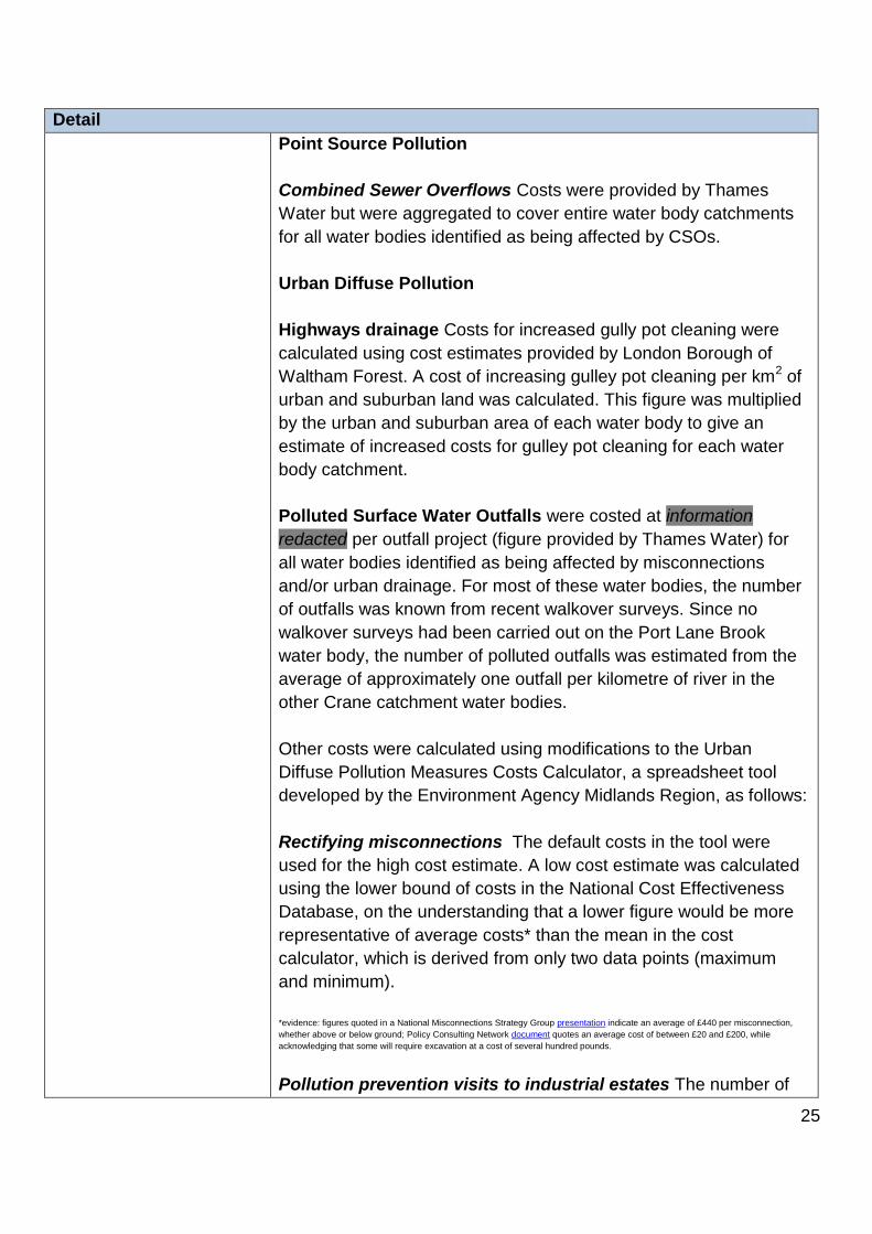
Point Source Pollution
Combined Sewer Overflows Costs were provided by Thames
Water but were aggregated to cover entire water body catchments
for all water bodies identified as being affected by CSOs.
Urban Diffuse Pollution
Highways drainage Costs for increased gully pot cleaning were
calculated using cost estimates provided by London Borough of
Waltham Forest. A cost of increasing gulley pot cleaning per km2 of
urban and suburban land was calculated. This figure was multiplied
by the urban and suburban area of each water body to give an
estimate of increased costs for gulley pot cleaning for each water
body catchment.
Polluted Surface Water Outfalls were costed at information
redacted per outfall project (figure provided by Thames Water) for
all water bodies identified as being affected by misconnections
and/or urban drainage. For most of these water bodies, the number
of outfalls was known from recent walkover surveys. Since no
walkover surveys had been carried out on the Port Lane Brook
water body, the number of polluted outfalls was estimated from the
average of approximately one outfall per kilometre of river in the
other Crane catchment water bodies.
Other costs were calculated using modifications to the Urban
Diffuse Pollution Measures Costs Calculator, a spreadsheet tool
developed by the Environment Agency Midlands Region, as follows:
Rectifying misconnections The default costs in the tool were
used for the high cost estimate. A low cost estimate was calculated
using the lower bound of costs in the National Cost Effectiveness
Database, on the understanding that a lower figure would be more
representative of average costs* than the mean in the cost
calculator, which is derived from only two data points (maximum
and minimum).
*evidence: figures quoted in a National Misconnections Strategy Group presentation indicate an average of £440 per misconnection,
whether above or below ground; Policy Consulting Network document quotes an average cost of between £20 and £200, while
acknowledging that some will require excavation at a cost of several hundred pounds.
Pollution prevention visits to industrial estates The number of
26
Detail
small and large industrial estates was counted using aerial
photography.
Awareness campaigns for the general public The default costs in
the tool were used as the high cost estimate. The low cost estimate
was based on an enhanced version of a current pilot campaign.
More accurate population figures for the catchment area of each
water body were obtained using data from the 2011 census.
Annual savings were included for awareness campaigns, based on
the results of the Anglian Water Keep it Clear campaign, where
blockages and associated costs were cut by 75%. Applied to
Thames Water’s current costs of £12 million per annum on
blockages covering 9 million customers, this gave an estimated
saving of £1 per dwelling.
Making Rivers More Natural
Project costs were used in cases where they were available (e.g.
London Rivers Action Plan; quotes from contractors). However, for
the majority of measures, area staff (Fisheries, Biodiversity,
Planning & Strategic Overview, and Catchment Coordinators)
estimated high and low costs using expert judgement, supported by
a list of recent projects in North East Thames and a list of cost
estimates for river restoration works from Halcrow (2008). The
National Cost-Effectiveness Database was used to supply costs in
cases where there was uncertainty concerning the type or extent of
works required.
Tackling Problem Invasive Species
The Biodiversity Technical Specialist used expert judgement to
estimate costs per km for a ten-year programme of invasive species
management for key invasive species. These costs were applied to
the length of river currently affected, as estimated by a Biodiversity
Officer with extensive knowledge of the catchment.
27
Detail
Willingness to pay
Value used
Central (default)
The communities living within the Crane catchment range from the
relatively deprived to the more affluent. Extensive reaches of the
River Crane and its tributaries are in open space and are used for
recreation, so a central willingness to pay value is a good
representation of the average.
NWEBS baseline
The NWEBS baseline was determined using the agreed comparative WFD status approach.
The 2013 classification was used to predict 2015 baseline status because it uses the most
complete set of sample data and best reflects the current ecological status of water bodies in the
Crane catchment between 2013 and 2015 .
There were a number of cases where better local information was available, where data for
relevant elements was not available, or where expert judgement indicated that the suggested
baseline was not representative of the situation in the water body. In these cases, the suggested
baseline was modified to better reflect the current NWEBS condition of the water body.
Km /km2or m3 of benefits
In most cases, the entire length/area of the water body was Actions to reduce pollution and tackle
invasive species will happen on a whole water body basis. Specific measures that have been
identified to improve physical habitat cover lengths the equivalent of the river line used as the
basis of the calculations. In the cases of the Yeading Brook (east arm) and the Port Lane Brook,
measures that have been identified to improve physical habitat do not cover the full length of the
water body so only a percentage of the water body was considered to be improved.
Where there are substantial culverts that cannot realistically be removed, the length of river
benefited was reduced proportionally for Flow and Safety.
Benefit lengths were decided by expert judgement. Decisions were made collectively during
meetings involving Neale Hider, Lucy Shuker, Laura Beardsworth, Amanda MacLean and Tom
Perry.
Adjustments to benefit lengths
Correcting for duplication of water body lengths
The Duke of Northumberland's River at Mogden (GB806100095) is a surface water transfer

28
Detail
water body in its own right, but is also included in the Crane (including part of the Yeading Brook)
(GB106039023030) water body river line. To avoid double counting benefits along this reach,
2.93 km of benefits (equivalent to the length of the Duke of Northumberland's River at Mogden)
were subtracted from the Crane water body.
Benefits from improvements to water bodies outside the Crane catchment
Improvements to water quality in the Colne catchment (in particular phosphate stripping at
sewage treatment works) are expected to provide some benefits to the Crane (), both branches
of the Duke of Northumberland's River (), and the Longford River.
In order to distribute these benefits in a straightforward and simple manner between the two
catchments it was decided to transfer the benefit lengths for Clarity and Plants from the Crane
operational catchment to the Colne operational catchment. This is based on the principle that
Clarity and Plants are the categories most impacted by actions to improve water quality in the
Colne catchment. We estimate that the benefits to plants from physical modification measures
will be roughly equal to the benefits to fish and invertebrates from water quality measures, so the
overall transfer of benefits between the two catchments should be reasonably accurate.
The methodology and reasoning for the transfer of benefit lengths to the Colne operational
catchment is described in Appendix A.
Once these adjustments are made, the total percentages of river length improved by the
recommended bundle of measures in the Crane operational catchment are, for each NWEBS
element:
Clarity 82%
Fish 90%
Invertebrates 67%
Plants 49%
Flow 54%
Safety 65%
Sensitivity testing WAG section 7
Sensitivity test results are as follows:

29
Detail
Baseline Whole life costs x 5 Whole life costs x 2 Whole life costs x 0.8
Change in one off costs for
BCR to approximate to 1.0
Bundle ref Bundle name BCR 1.96 0.392367387 0.98 2.45 1.105096831
1 Crane midpoint costs NPV £ 43034837.34 -135934532 -1707505.00 51983305.81 2x
50% decrease in km
benefited Using low WTP value Using central WTP value Using high WTP value Risk of failure is 0% Risk of failure is 25% Risk of failure is 50%
1.01 1.62 1.96 2.30 2.62 1.96 1.31
603867.66 27891158.10 43034837.34 58178516.58 72293897.23 43034837.34 13775777.44
This assessment passes all of the sensitivity tests except for Whole Life Costs x 2, which
resulted in a BCR of just below 1. However, this is considered to be an unrealistic scenario. Our
own high-cost scenario passed the cost benefit analysis with a BCR of 1.65. The majority of
costs in the high-cost scenario are either provided by the water company, or uncertainty has
already been built into the costings in assigning a maximum likely cost. Therefore doubling these
figures is not considered to be realistic.
Appraisal Summary Table WAG section 3 and 5
The AST records the following benefits as having significant positive benefit:
Recreation and tourism
Aesthetic value
Intellectual and scientific, educational
Provision of habitat
The following benefit categories were recorded as having minor positive benefit in the AST:
Fresh water
Existence Values
Social relations
Much of the benefit recorded in the above categories is not monetised in the calculated NWEBS
benefits for the catchment. This means that the overall benefit for the catchment is likely to be
higher than estimated in the Present Value Benefits figures shown above.
None of the benefit categories recorded an overall negative impact as a result of the proposed
measures. However, potential minor negative impacts were identified in the case of:
Heritage - Minor adverse impacts on the substantial cultural heritage of the Crane were identified as possible, but avoidable. Impacts can be prevented or mitigated for by designing proposals so that they will not damage the cultural heritage (e.g. by installing a
30
Detail
fish pass around a historic mill structure, thus avoiding change to the historic structure itself).
Water for non-consumptive use - Minor adverse impacts of weir removal could limit the opportunities for future hydropower schemes. However, any scheme would be small-scale and there is currently no hydropower in the Crane catchment. Improved flow in the lower Crane should have a positive impact on the potential for hydropower that would balance out these negative impacts.
These minor negative impacts should not affect objectives.
Engagement operational instruction (450_13) section 2
Internal
The Crane Catchment Coordinator (Amanda MacLean) held a series of meetings and
discussions with members of the following teams:
Costing measures – Biodiversity (Neale Hider, John Bryden), Geomorphology (Lucy Shuker), Fisheries (Phil Belfield, Planning & Strategic Overview (Anna Parr), Integrated Environment Planning (Tom Perry), Karen Douse (Land & Water)
NWEBS benefits – Biodiversity (Neale Hider), Geomorphology (Lucy Shuker), Integrated Environment Planning (Laura Beardsworth, Tom Perry)
AST - Integrated Environment Planning (Laura Beardsworth)
External
Measures incorporate WFD-related actions from the The Crane Valley - a Water Framework
Directive Catchment Plan produced by the Crane Valley Partnership.
A summary of the process was discussed informally with several key members of the Crane
Valley Partnership, including the catchment host. Partnership members have been invited to hear
further details on the process and results in February 2014.
Any other supporting information such as key uncertainties, other rules of thumb used
and key assumptions made
Nominally the base year for the financial numbers in all CBAs Nationally is 2012 based on the
NWEBS values. Consequently all other financial numbers should be either inflated or deflated to
their 2012 level. However due to the overall uncertainties around costs, savings and other
financial benefits we have not applied an inflation or deflation factor. It is thought to try and use
RPI/CPI to adjust costs to a 2012 base level would suggest a level of accuracy to the financial
numbers we do not have. It is assumed the use of cost ranges and the standard national
sensitivity testing will help to assure a BCR outcome fit for the purpose of a high level
assessment.
31
Detail
COSTS
The costs are mostly derived from local costs (based on data from local projects, studies
and experience of area staff); in some cases they were derived from the National Cost
Effectiveness Database and taken as provided there.
Capital costs are placed in the first year of the assessment (2015/16) unless we have
evidence of where capital costs will be spent over the time horizon.
We assume operational costs will occur in the first year after capital costs 2016/17 and will
continue for the remaining time horizon. Operational costs that occur for shorter period of
time are included in capital costs.
Water Companies’ costs for water quality measures are placed in line with the schedule
provided by them.
Urban Diffuse Pollution actions were costed using the National Urban Diffuse Pollution
Calculator, with modifications as described above under 'Costs'.
BENEFITS
It is assumed benefits start two years after capital expenditure (so in most cases 2017/18)
and will continue for the remaining time horizon unless we have local or national evidence.
As a rule NWEBS baselines and status changes are selected in accordance with National
recommendations in the FAQ. However local evidence and expertise was used to
override these rules of thumb when required.
We do not include any financial cost savings or additional financial benefits unless we
have local or national evidence.
32
Appendix A
The methodology and reasoning for transferring benefit lengths to the Colne operational catchment is described
below.
Duke of Northumberland’s River at Heathrow (water body ID: GB806100108)
The whole length of this river will benefit from water quality improvements in the Colne.
Longford River (included in Port Lane Brook water body ID: GB106039023450)
The whole length of this river will benefit from water quality improvements in the Colne.
River Crane downstream of Duke of Northumberland’s River at Heathrow; Duke of Northumberland’s River at
Mogden (lower section of Crane (including part of the Yeading Brook) water body ID: GB106039023030; water body
ID: GB806100095)
SAGIS modelling found that 43% of the phosphate in the Crane was derived from sewage treatment works in the
Colne. We therefore need to apportion 43% of the benefits to the Colne catchment. The easiest way to do this is to
apportion the length improved between the two catchments. The Crane, downstream of the Duke of Northumberland’s
River at Heathrow, is 10km, so 43% is 4.3km. The Mogden reach of the Duke of Northumberland’s River is 2.93km, so
43% is 1.26km. We have therefore apportioned 4.3km of benefits from the Crane and 1.26km of benefits from the
Duke of Northumberland’s River to the Colne.