The Confederate Retreat - SCHS...
8
Originally published in El Defensor Chieftain newspaper, Saturday, March 3, 2012. © 2012 by Paul Harden. Article may be cited with proper credit to author. Article is not to be reproduced in whole or placed on the internet without author’s permission. Copyright: By Paul Harden For El Defensor Chieftain [email protected] This year marks the 150th anniversary of the Civil War in New Mexico. Last month's article discussed the campaign, the Battle at Valverde, and the Confederate occupation of Socorro. Following the Battle at Glorieta Pass, the Confederate's forced return to Texas, on foot, became one of the longest retreats in U.S. Military history. After Valverde After the Battle of Valverde, on February 21, 1862, Gen. Henry Hopkins Sibley moved his Confederate army north. Hoping to confiscate supplies along the way to feed his army, they entered Albuquerque and Santa Fe, only to find most federal supplies had either been removed or destroyed. On March 26, Gen. Edward Canby departed Fort Craig with a Union force of about 2,500 men to intercept the Texans. The New Mexico Volunteers remained behind to protect Fort Craig. On the same day, an advanced guard of Confederate soldiers departed Santa Fe for Fort Union. With the Union army 150 miles away, their travel was far removed from the enemy. While resting at a water stop near Glorieta Pass, the rebels were totally surprised as a volley of canon fire and grapeshot began to gun down the men. These were the guns of the Colorado Volunteers. Leaving Denver, the Coloradans marched over 400 miles through deep snows and frigid cold weather to offer aid to New Mexico. The two armies arrived in Glorietta Pass at the same time. The battle was on. Both armies called for reinforcements; the main Battle of Glorieta was fought on March 28 with the Confederate army seemingly gaining the upper hand. A detachment of Coloradans, led by Maj. John Chivington, was sent to attack from the rear. Enroute, his men discovered, and destroyed, the entire Confederate supply train near the entrance to Apache Canyon, and ran off their horses. The Texan Retreat The loss of the supply wagons and most of their horses decimated the Confederate Army, bringing the New Mexico campaign to an abrupt end. With no food for his army, Sibley's Brigade had no choice except to begin a long and arduous 800- mile retreat back to Texas. Most of the men were on foot. The Confederate Retreat The Confederate Retreat Photo by Paul Harden (reenactment photo) On April 17, 1862, the Sibley Brigade camped on the Rio Puerco near the Rio Grande. That night, they abandoned the camp and began their retreat through the mountains around Socorro to escape Union forces, leaving nearly everything behind.
Transcript of The Confederate Retreat - SCHS...

Originally published in El Defensor Chieftain newspaper, Saturday, March 3, 2012.
© 2012 by Paul Harden. Article may be cited with proper credit to author. Article is not to be reproduced in whole or placed on the internet without author’s permission.
Copyright:
By Paul HardenFor El Defensor [email protected]
This year marks the 150th anniversary of the Civil War in New Mexico. Last month's article discussed the campaign, the Battle at Valverde, and the Confederate occupation of Socorro. Following the Battle at Glorieta Pass, the Confederate's forced return to Texas, on foot, became one of the longest retreats in U.S. Military history.
After ValverdeAfter the Battle of Valverde, on February 21,
1862, Gen. Henry Hopkins Sibley moved his Confederate army north. Hoping to confiscate supplies along the way to feed his army, they entered Albuquerque and Santa Fe, only to find most federal supplies had either been removed or destroyed.
On March 26, Gen. Edward Canby departed Fort Craig with a Union force of about 2,500 men to intercept the Texans. The New Mexico Volunteers remained behind to protect Fort Craig.On the same day, an advanced guard of Confederate soldiers departed Santa Fe for Fort Union. With the Union army 150 miles away, their travel was far removed from the enemy. While resting at a water stop near Glorieta Pass, the rebels were totally surprised as a volley of canon fire and grapeshot began to gun down the men.
These were the guns of the Colorado
Volunteers. Leaving Denver, the Coloradans marched over 400 miles through deep snows and frigid cold weather to offer aid to New Mexico. The two armies arrived in Glorietta Pass at the same time. The battle was on.
Both armies called for reinforcements; the main Battle of Glorieta was fought on March 28 with the Confederate army seemingly gaining the upper hand. A detachment of Coloradans, led by Maj. John Chivington, was sent to attack from the rear. Enroute, his men discovered, and destroyed, the entire Confederate supply train near the entrance to Apache Canyon, and ran off their horses.
The Texan RetreatThe loss of the supply wagons and most of their
horses decimated the Confederate Army, bringing the New Mexico campaign to an abrupt end. With no food for his army, Sibley's Brigade had no choice except to begin a long and arduous 800-mile retreat back to Texas. Most of the men were on foot.
The Confederate RetreatThe Confederate Retreat
Photo by Paul Harden (reenactment photo)On April 17, 1862, the Sibley Brigade camped on the Rio Puerco near the Rio Grande. That night, they abandoned the camp and began their retreat through the mountains around Socorro to escape Union forces, leaving nearly everything behind.
By April 15, the brigade reached Los Lunas. One of the Confederate soldiers was 22 year old Alfred Peticolas, a private in the 4th Regiment of Texas Volunteers, Company C. He kept a daily diary of the campaign, published in the book “Rebels on the Rio Grande” by the late Don Alberts. This book still serves as an irreplaceable eye-witness account of the New Mexico campaign – and the Texan retreat from a Confederate soldier's point of view.
On April 16, Peticolas described their departure from Los Lunas: “The dust and sand has been extremely distressing all day as it blows over us in clouds and almost blinds us as we struggle along through the heavy sand.”
The command traveled through the New Mexico dust storm with virtually no visibility to camp near the village of Jarales, south of Belen. The wind and dust blew all night long.
The next morning, April 17, Peticolas recorded their shocking discovery: “We discovered that confounded cavalry of the enemy right opposite to us on the other side of the river this morning, and later we found that the whole force of the enemy had gained on us during the night.” With no visibility in the dust storm, the two armies had camped nearly next to each other!
Peticolas fully understood the predicament when he penned, “The novel spectacle was here exposed of two hostile armies marching side by side down on opposite sides of the same river and in full view of each other. ... I judged them to be between 2000 and 2500 men and a splendid train of about 100 wagons. ... We know that [Col. Christopher] Carson has 600 mexicans at Craig.
–
We are about 1500 or 1800 strong, and think we can get through to our supplies in the lower country.
Peticolas is referring to the last of the command's provisions Col. William Steele's remaining supply wagons at Mesilla. If they can just travel the 200 miles to Mesilla, the men might have a bed roll to sleep in and enjoy full rations once again.
The command marched 15 miles that day and camped in a flat meadow between the Rio Grande and a small stream with flowing water. This stream was the Rio Puerco. Their campsite was located just east of where today's I-25 crosses the Rio Puerco with a commanding view of Ladron peak to the west.
Sibley did not shake Canby's forces. Canby camped opposite the Rio Puerco camp on the east bank of the Rio Grande, near the village of Contreras, in full view of the Texans. Furthermore, Sibley's spies discovered an additional 2,000 soldiers the Colorado Volunteers camped several miles up the river.
Peticolas expressed his fears, and likely that of many of the Texans, when he wrote, “And now our position begins to be quite critical, and the object of the enemy begins to be apparent. They intend to surround us and hem us in our every side and compel us to surrender, and we are in a fix: 6000 in the rear, 2000 on our flank, and 600 in a strong fort in front, and but one way to get out ...”
Citing 6,000 men in their rear was an exaggeration, though Sibley's command was now clearly outnumbered by the enemy. The Texans
–
––
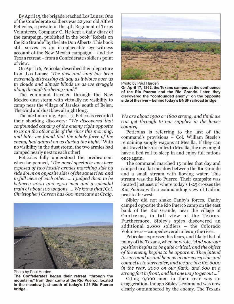
Photo by Paul HardenThe Confederates began their retreat “through the mountains” from their camp at the Rio Puerco, located in the meadow just south of today’s I-25 Rio Puerco bridge.
Photo by Paul HardenOn April 17, 1862, the Texans camped at the confluence of the Rio Puerco and the Rio Grande. Later, they discovered the “confounded enemy” on the opposite side of the river – behind today’s BNSF railroad bridge.

were also wrong in assuming Canby was about to launch an attack to demand their surrender.
Canby is marching down the Rio Grande with nearly 4,000 mouths to feed every day with a limited supply train. Demanding the surrender of the Texans was not an option. Canby could not afford to feed another 1,800 men. He just simply wanted to keep them moving out of New Mexico.
Council of War Sibley did not know Canby's plan. From his view point, he saw a well supplied superior enemy force compared to his own poorly provisioned army of demoralized men. About sundown, Gen. Sibley called a Council of War with his senior officers to decide what to do. Peticolas got it right. They were nearly surrounded by the enemy. Boxed in to the north, east and south; there was only one way out ? to the west. Unfortunately, to the west lie the looming Ladron peak, the Magdalena and San Mateo Mountains, and no trails for their wagons or artillery.
During the Battle at Valverde, Capt. Bethel Coopwood was sick with smallpox at Mesilla. After recovering, Coopwood took a circuitous route through the San Mateo mountains to join the command at Albuquerque.
Recalling how Coopwood had bypassed Fort Craig a month earlier, Sibley summoned the captain to his tent. Coopwood described his route to the Council of War, though expressed his uncertainty as to how suitable it would be for the wagons and artillery. They reasoned if Coopwood made it from Mesilla to Albuquerque without detection, they could return to Mesilla by following the same route in reverse.
The Council of War issued their orders to the men. About 7 p.m., the entire force departed the Rio Puerco camp under the cloak of darkness to try Coopwood's route through the mountains. The men took only what they could carry and headed for the towering nighttime silhouette of Ladron Peak. Nearly everything else, tents, cookware, and wagons, were discarded at the Rio Puerco.
Coopwood's Route through the Mountains“After some trouble we all got fairly started
and marched till two o'clock [in the morning] up a gradual slope over rough uneven ground and then down a canion [sic] till we reached the hilly cedar country of the mountains,” described Peticolas.
Their route passed through today's Sevilleta National Wildlife Refuge, as shown on the accompanying map. They camped “in the canion” of the waterless Tio Lino arroyo, north of the Rio Salado. This campsite was found by the author under an historical permit in 1989.
In all, the retreating men marched 29 miles that day, half of it in the pitch dark. They must have been utterly exhausted as they made their dry camp, with no water, at 2 o'clock in the cold morning.
Meanwhile, back at the Rio Puerco, the sick and

Photo by Paul HardenTraveling along the Rio Salado, the brigade found the meager flow of water so salty, it was unfit to drink. The water disappears under the surface, forming pockets of quick sand in places.
Photo by Paul HardenAfter an all-night march, the Texans finally found water and camped on the Rio Salado at Silver Creek – behind the Polvadera mountains. Here, they waited all day for Col. Green and the last of the supply wagons to arrive.
Photo by Paul HardenWhen the Texans departed the Rio Puerco camp, they left behind just about everything they couldn’t carry. Broken dishes, earthenware, and even whiskey bottles can still be found today – if you know where to look.
injured men left behind kept the fires burning all night, giving the illusion of a brisk camp. And, it worked. The nighttime departure of Sibley's Brigade went unnoticed by the Union forces on the other side of the river. The following morning, the abandoned camp and 1,800 missing enemy soldiers must have been quite a sight.
At the Tio Lino camp, the exhausted Texans were informed they would get breakfast about four miles ahead where there was water. The command broke camp, and as Peticolas noted, the four miles became eight, adding, “We then came to salt water sink and camped for the remainder of the day ...”
The men had marched down the Tio Lino arroyo, then west along the Rio Salado to Silver
Creek. It is located about 11 miles west from today's I-25 Rio Salado bridge, a bit behind the Polvadera mountains.
Even today, a trickle of water flows almost constantly through the Rio Salado around Silver Creek. It pops out of the sand and flows for a half-mile, then disappears back into the sand to reappear again some distance later. It is a very salty water, almost unfit to drink, as noted by Peticolas, “This water we found extremely unpalatable and salty, and the coffee made from it was hardly fit to drink atall, and as we had nothing but coffee and bread, we had pretty hard fare.”
Along the Rio SaladoOn April 19, the command continued west along the Rio Salado. For several miles, it winds through a narrow rock canyon, somewhat like a miniature Grand Canyon. It gives the appearance of being the most desolate place on Earth. And to the Texans, it was.
After five or six miles, they found a spring near the confluence of La Jencia gulch and the Rio Salado to moisten their parched lips. Men on horseback scouted ahead to find the best route. They reported the Rio Salado was impassable about a mile ahead due to a rock filled narrow passage. This is “The Box,” as shown on most modern maps.
The decision was made to follow the fairly large arroyo leading to the south: La Jencia gulch. Back on the trail, they journeyed down the sandy canyon another five or six miles. At this point, there is a fork in La Jencia, one to the south with –

Photos by Paul HardenA few miles north of the old Water Canyon Lodge on U.S. 60 lies the secluded green trees of La Jencia springs on today’s La Jencia Ranch. Some of the Confederates found this hidden water hole on their way toward Magdalena.
Photo by Paul HardenSibley’s Brigade struggled for miles with their wagons and artillery along the narrow and sandy bottom of La Jencia gulch.
a slight flow of water, and the other to the southwest that is dry and dusty, but more suitable for the wagons.At this point, military order was falling apart. Peticolas noted, “every man for himself, upon the way,” and later, “No order was observed, no company staid together.” It appears the bulk of the command continued up the dry fork of the canyon with the wagons and artillery.
Some of the men took the left branch, following the trickle of water. After several miles, the deep canyon eventually led to a substantial spring. Artifacts, including two canon balls, have been found at this spring near today's La Jencia Ranch.
Peticolas remained with the wagons and artillery, as he wrote, “When we got to the point where you must leave the canion, the hill was extremely steep and high. (Col.) Scurry got down from his horse, called for volunteers to help the
artillery up the hill. ... Then away, away, southwest across a vast plain, the way picked by our pilot (Capt. Coopwood) led.”
This described perfectly the men emerging from La Jencia near the Ligon Ranch and marching across the Water Canyon plains towards today's Magdalena. It is also known that in hauling the artillery out of the canyon, one of the canons suffered a broken axle. It was buried to conceal it from the enemy, but later found by a ranch hand in the 1930s. It remains in a private collection in Socorro.
While the men suffered on the trail with little water or food, a select few seemed to be traveling in relative comfort. Peticolas remarked, “We have quite a number of women along, the wives and daughters of Mexican citizens who have thought it most prudent for them to leave because of their southern principles. Another soldier, Private W.
Photo by Paul HardenHoping for quick travel along the Rio Salado, scouts found “The Box” – a narrowing of the canyon filled with house-sized boulders. This obstruction forced the command down La Jencia gulch instead.
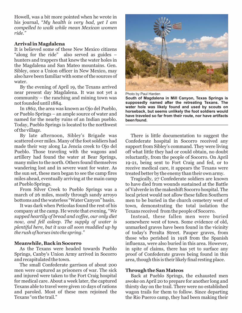
Photo by Paul HardenSouth of Magdalena in Mill Canyon, Texas Springs is supposedly named after the retreating Texans. The water hole was likely found and used by scouts on horseback, but seems unlikely the foot soldiers would have traveled so far from their route, nor have artifacts been found.
Howell, was a bit more pointed when he wrote in his journal, “My health is very bad, yet I am compelled to walk while mean Mexican women ride.”
Arrival in MagdalenaIt is believed some of these New Mexico citizens “along for the ride” also served as guides – hunters and trappers that knew the water holes in the Magdalena and San Mateo mountains. Gen. Sibley, once a Union officer in New Mexico, may also have been familiar with some of the sources of water.
By the evening of April 19, the Texans arrived near present day Magdalena. It was not yet a community the ranching and mining town was not founded until 1884.
In 1862, the area was known as Ojo del Pueblo, or Pueblo Springs an ample source of water and named for the nearby ruins of an Indian pueblo. Today, Pueblo Springs is located to the northwest of the village.
By late afternoon, Sibley's Brigade was scattered over miles. Many of the foot soldiers had made their way along La Jencia creek to Ojo del Pueblo. Those traveling with the wagons and artillery had found the water at Bear Springs, many miles to the north. Others found themselves wandering lost and in severe want for water. As the sun set, these men began to see the camp fires miles ahead, eventually arriving at the main camp at Pueblo Springs.
From Silver Creek to Pueblo Springs was a march of 26 miles, mostly through sandy arroyo bottoms and the waterless “Water Canyon” basin.
It was dark when Peticolas found the rest of his company at the camp. He wrote that evening, “We supped heartily of bread and coffee, our only diet now, and fell asleep. The supply of water is plentiful here, but it was all soon muddied up by the rush of horses into the spring.”
Meanwhile, Back in SocorroAs the Texans were headed towards Pueblo
Springs, Canby's Union Army arrived in Socorro and recapitulated the town.
The small Confederate garrison of about 200 men were captured as prisoners of war. The sick and injured were taken to the Fort Craig hospital for medical care. About a week later, the captured Texans able to travel were given 10 days of rations and paroled. Most of these men rejoined the Texans “on the trail.”
–
–
There is little documentation to suggest the Confederate hospital in Socorro received any support from Sibley's command. They were living off what little they had or could obtain, no doubt reluctantly, from the people of Socorro. On April 19-21, being sent to Fort Craig and fed, or to receive medical care, it appears the Texans were treated better by the enemy than their own army.
Tragically, 27 Confederate soldiers are known to have died from wounds sustained at the Battle of Valverde in the makeshift Socorro hospital. The local priest would not allow these fallen Southern men to be buried in the church cemetery west of town, demonstrating the total isolation the Texans received from the people of Socorro.
Instead, these fallen men were buried somewhere west of town. Some evidence of old, unmarked graves have been found in the vicinity of today's Peralta Street. Pauper graves, from those who perished in 1918 from the Spanish influenza, were also buried in this area. However, in spite of claims, there has yet to surface any proof of Confederate graves being found in this area, though this is their likely final resting place.
Through the San MateosBack at Pueblo Springs, the exhausted men
awoke on April 20 to prepare for another long and thirsty day on the trail. There were no established wagon trails for them to follow. Since departing the Rio Puerco camp, they had been making their
own road through the mountains where few men had been before, and certainly not an army of some 1,800 men.
From Pueblo Springs, according to Peticolas, “We started about 9 a.m. this morning and traveled 15 miles over a rolling country to the next water ... our road lay over a broad stretch of rolling country, destitute of timber but affording a pretty good road.”
Peticolas and the Texans headed south, roughly following the route of today's NM-107. They camped “at the next water” of Alameda Springs, located in the Magdalena mountains. The small canyon shielded their campfires from being seen at Fort Craig less than 20 miles away.
The next morning, the command crossed the valley to the protection of the San Mateo mountains. For hours, Fort Craig was clearly visible in the distance. The wagons and artillery traveled slowly, careful not to raise dust and alert the troops at the enemy fort of their presence. Once in the mountains, travel remained slow as they hauled their wagons and canons up one hill then over another.
Water was finally found at Turkey Springs, where they camped for the night. Some of the men crossed a ridge into a meadow of grass, today called The Park, to graze the draft animals.
Once again deep in a canyon, their campfires were well shielded from the prying eyes at Fort Craig. So far, their plan to evade detection by the enemy was working.
The next day, the command continued up steep ridges and down into small canyons. It was punishing on the men and animals pulling the
wagons and canons. Peticolas' company was given one of the canons to get through the mountains. He recorded on April 22, “We traveled some 5 or 6 miles, helping our gun up the worst hills, when we suddenly came on to a vast canion running directly across our direction and seemingly impassible.”
This was East Red Canyon. After spending hours getting the guns across the deep ravine, the men continued another 10 miles before finding water at Nogalita Springs, near the head of Nogal Canyon.
Peticolas closed his diary that evening with, “Oh, the water, the good water!! Here we camped as we did last night, with no guard, and our artillery 1/2 mile from the water.”
On April 23, the grueling march through the San Mateos continued. The only water they found that day was the small water hole at Peñasco Springs. They marched and marched, and as Peticolas described it, “till late at night and found no water, and so we made a dry camp with nothing to eat or drink, and slept all night.”
Capt. Coopwood went exploring in the middle of the night for water, returning to camp with the good news. The command took to the march to Coopwood's water four miles away at the crack of dawn.
“We reached it about 9 o'clock and found it to be a small rapid stream of water in the valley of an immense canion, 800 or 1000 feet deep. … We
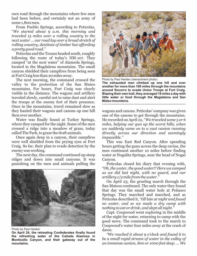
Photo by Paul Harden (reenactment photo)The exhausted men climbed up one hill and over another for more than 100 miles through the mountains around Socorro to evade Union Troops at Fort Craig. Blazing their own trail, they averaged 18 miles a day with little water or food through the Magdalena and San Mateo mountains.
Photo by Paul HardenOn April 24, the retreating Confederates finally found the refreshing water of the Cañada Alamosa in Monticello Canyon, and their gateway out of the mountains.
laid over on this creek, which is called the Hondo.” Peticolas was describing the long awaited water of the Ca ada Alamosa – today's Monticello Canyon.
His misidentification as the Hondo river has made many historians believe that Sibley's command was no longer being led by native scouts.
After resting by the flowing stream, the men were ordered to wrestle the artillery out of the canyon before sunset. Once this was done, they made camp. They could now see the Rio Grande and the Fra Cristobal mountains to the east.
As the sun rose the next day, the partially rejuvenated men set off following the Canada Alamosa towards the Rio Grande. They were finally free of the mountains with the enemy force at Fort Craig far in the rear. They camped on the Cuchillo Negro creek, near present day Truth or Consequences.
Though their travel was now along the river with an established road, the men still suffered for want of food. They pushed to the south in the hopes of reaching Mesilla, where Col. Steele's supply wagons would hopefully feed them.
On April 27, ten days after departing the Rio Puerco, Peticolas finally reported, “[We met] the provision train Steele had started up to us. We ate for breakfast this morning a rib or two of an old broke-down work ox we had along, without salt. ... We all ate heartily of bread and coffee, but got nothing else brought up.”
With the above description, it makes one wonder exactly what supplies were in Steele's wagons. Obviously, little food. Still, it was a feast compared to the past ten days through the mountains.
Peticolas also sadly reminisced with “Yesterday two men were left on the road, too sick to be moved. We also left two in the mountains near Craig. There were thrown out of the wagons by Major Brownrigg and one out of the end of Sibley's wagon. Sibley is heartily despised by every man in the brigade for his want of feeling, poor generalship, and cowardice.”
Another soldier, Theophilus Noel, wrote in his memoirs regarding Sibley, “The only thing I ever regretted was that the drunken individual who was the cause of all our misfortune was also kept from starving ...”
It is known several of the retreating men perished on the trail through the mountains.
ñ
End of a JourneyThe remnants of Sibley's Brigade remained
around Mesilla and Ft. Bliss regaining their strength. Upon learning of the approach of Gen. James Carleton's “California Column” of some 2,300 soldiers, the Texans departed the El Paso region in June. They arrived in San Antonio, Texas in several waves throughout August and September – with the majority of their prized canons intact.
And thus ended one of the most tortuous retreats of an American army over 800 miles, mostly on foot, from Glorieta to San Antonio. These men continued on fighting for the Confederacy, with some loosing their lives, in the Louisiana campaigns.
These were brave young men loyal to the Southern cause. Their failure in New Mexico was not due to any lack of desire by these men, but due to poor leadership, a series of misfortunes, and being desperate for food and supplies for the majority of the campaign. As one participant summed it up, “We were starved out of New Mexico ? not run out.”
Some of the references used in this article:“Rebels on the Rio Grande; the Civil War Journal of A.B. Peticolas” by Don Alberts; “Autobiography and Reminiscences of Theophilus Noel,” by Theophilus Noel (4th TMV, Co. A); “Turmoil in New Mexico” by William Keleher; “Colorado Volunteers in New Mexico” by Ovando Hollister; “The Confederate Army of New Mexico” by Martin Hardwick Hall; the Official Records of the War of the Rebellion; and field work by the author.
–


![ENY4Y^ZYUZ - Houston LGBT History.org · ncpqml?jgrw md rfc ucci 9kuwm7kk cuuj' %[oxoyotmak]gxynox\kkq&cwoykgtjw 4xxoxygty 4wy7owkiyuwluwynk4j[uigyk?nuyuh^16wg\luwj5gwyut rdeouaag9](https://static.fdocuments.net/doc/165x107/5accd3bd7f8b9a73128d45ac/eny4yzyuz-houston-lgbt-md-rfc-ucci-9kuwm7kk-cuuj-oxoyotmakgxynoxkkqcwoykgtjw.jpg)