The Colorado River Basin: An Overview - Colorado … and as the origin of the Green River in the...
8
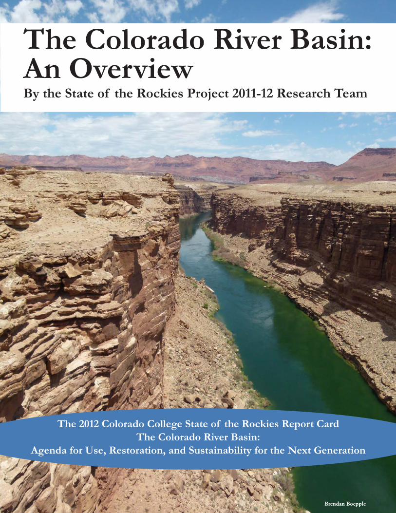
The Colorado River Basin: An Overview By the State of the Rockies Project 2011-12 Research Team Brendan Boepple The 2012 Colorado College State of the Rockies Report Card The Colorado River Basin: Agenda for Use, Restoration, and Sustainability for the Next Generation
Transcript of The Colorado River Basin: An Overview - Colorado … and as the origin of the Green River in the...
The Colorado River Basin: An OverviewBy the State of the Rockies Project 2011-12 Research Team
Brendan Boepple
The 2012 Colorado College State of the Rockies Report CardThe Colorado River Basin:
Agenda for Use, Restoration, and Sustainability for the Next Generation
The 2012 State of the Rockies Report Card Basin Overview 25
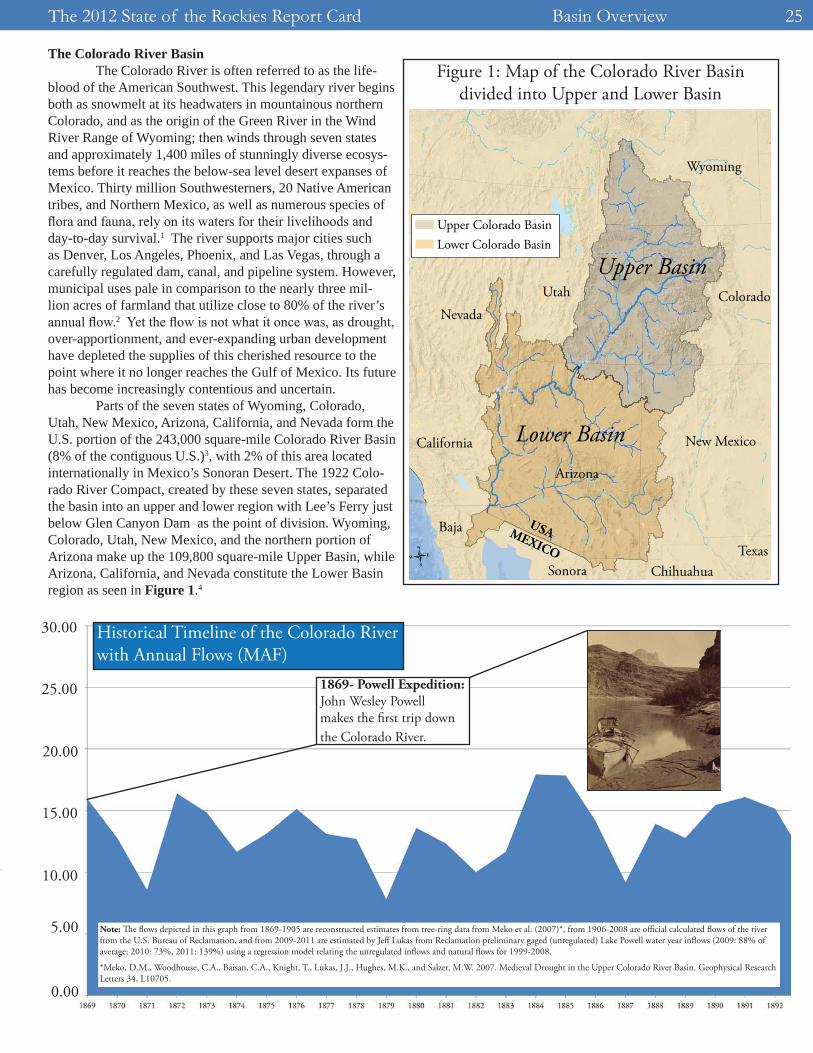
The Colorado River Basin The Colorado River is often referred to as the life-blood of the American Southwest. This legendary river begins both as snowmelt at its headwaters in mountainous northern Colorado, and as the origin of the Green River in the Wind River Range of Wyoming; then winds through seven states and approximately 1,400 miles of stunningly diverse ecosys-tems before it reaches the below-sea level desert expanses of Mexico. Thirty million Southwesterners, 20 Native American tribes, and Northern Mexico, as well as numerous species of flora and fauna, rely on its waters for their livelihoods and day-to-day survival.1 The river supports major cities such as Denver, Los Angeles, Phoenix, and Las Vegas, through a carefully regulated dam, canal, and pipeline system. However, municipal uses pale in comparison to the nearly three mil-lion acres of farmland that utilize close to 80% of the river’s annual flow.2 Yet the flow is not what it once was, as drought, over-apportionment, and ever-expanding urban development have depleted the supplies of this cherished resource to the point where it no longer reaches the Gulf of Mexico. Its future has become increasingly contentious and uncertain. Parts of the seven states of Wyoming, Colorado, Utah, New Mexico, Arizona, California, and Nevada form the U.S. portion of the 243,000 square-mile Colorado River Basin (8% of the contiguous U.S.)3, with 2% of this area located internationally in Mexico’s Sonoran Desert. The 1922 Colo-rado River Compact, created by these seven states, separated the basin into an upper and lower region with Lee’s Ferry just below Glen Canyon Dam as the point of division. Wyoming, Colorado, Utah, New Mexico, and the northern portion of Arizona make up the 109,800 square-mile Upper Basin, while Arizona, California, and Nevada constitute the Lower Basin region as seen in Figure 1.4
0.00
5.00
10.00
15.00
20.00
25.00
30.00
1869- Powell Expedition: John Wesley Powell makes the �rst trip down the Colorado River.
Historical Timeline of the Colorado River with Annual Flows (MAF)
Note: �e �ows depicted in this graph from 1869-1905 are reconstructed estimates from tree-ring data from Meko et al. (2007)*, from 1906-2008 are o�cial calculated �ows of the river from the U.S. Bureau of Reclamation, and from 2009-2011 are estimated by Je� Lukas from Reclamation preliminary gaged (unregulated) Lake Powell water year in�ows (2009: 88% of average; 2010: 73%, 2011: 139%) using a regression model relating the unregulated in�ows and natural �ows for 1999-2008.
*Meko, D.M., Woodhouse, C.A., Baisan, C.A., Knight, T., Lukas, J.J., Hughes, M.K., and Salzer, M.W. 2007. Medieval Drought in the Upper Colorado River Basin. Geophysical Research Letters 34, L10705.
Figure 1: Map of the Colorado River Basin divided into Upper and Lower Basin
-
Upper Basin
Lower Basin
USAMEXICO
Upper Colorado BasinLower Colorado Basin
Wyoming
Colorado
New Mexico
Arizona
UtahNevada
California
TexasChihuahuaSonora
Baja
Basin Overview The 2012 State of the Rockies Report Card26
Laws and Apportionment The Colorado River Basin is ruled by a compilation of decrees, rights, court decisions, and laws that together are referred to as the “Law of the River.” The keystone of these “commandments” is the 1922 Colorado River Compact, an interstate agreement created by the seven basin states with provisions for general water allotments, including a 7.5 mil-lion acre feet (maf) annual delivery requirement from the Up-per to the Lower Basin.6 The 1928 Boulder Canyon Project Act (along with the 1963 Supreme Court decision in Arizona v. California) divided the Lower Basin’s 7.5 maf—with an extra one maf in wet years—between Arizona, California, and Nevada.7 The 1948 Upper Colorado River Basin Com-pact divided the Upper Basin’s average allotment of 7.5 maf among the five states.8 States allocate their individual shares of the waters of the Colorado River and ultimately have the highest authority after the Secretary of the Interior. The Sec-retary of the Interior is often called the “water master” of the Colorado River, as he/she has the final ruling on nearly every conflict, be it the definition of “beneficial use” or the creation of shortage guidelines.9
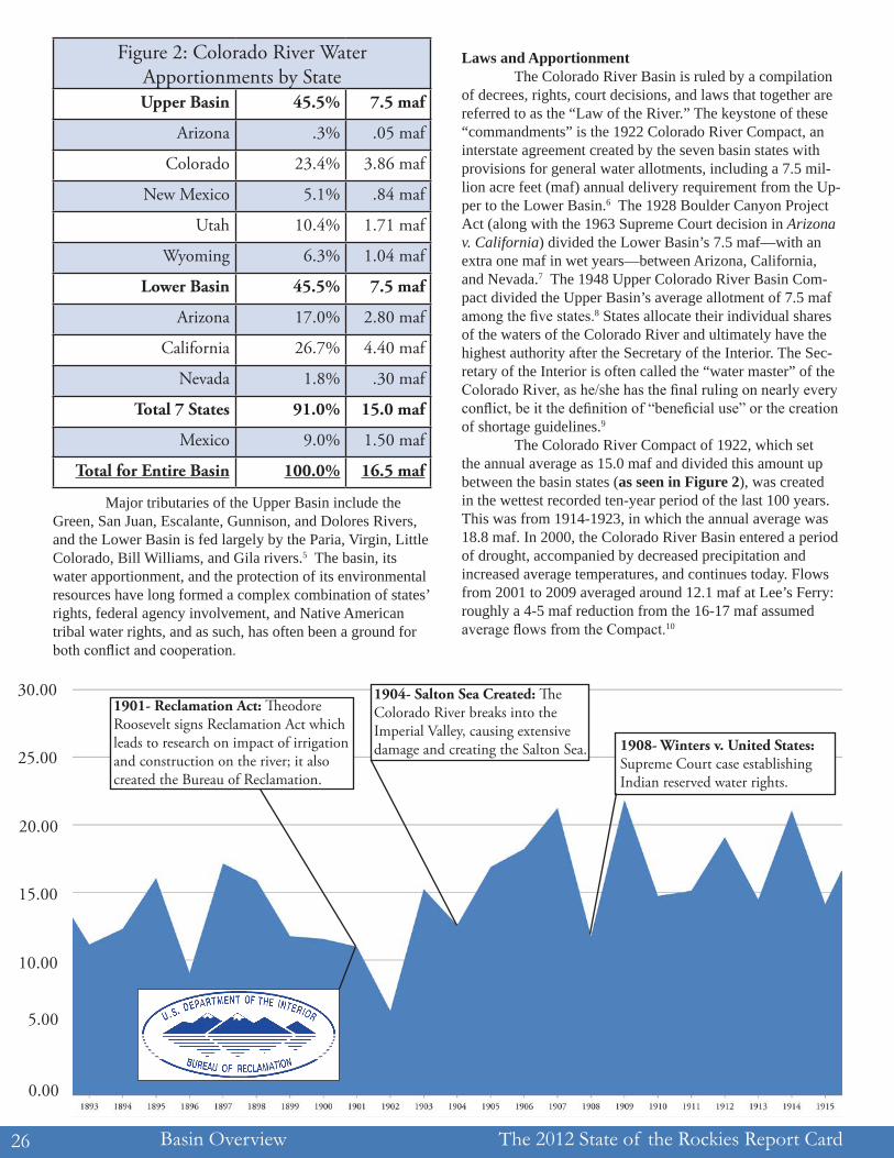
The Colorado River Compact of 1922, which set the annual average as 15.0 maf and divided this amount up between the basin states (as seen in Figure 2), was created in the wettest recorded ten-year period of the last 100 years. This was from 1914-1923, in which the annual average was 18.8 maf. In 2000, the Colorado River Basin entered a period of drought, accompanied by decreased precipitation and increased average temperatures, and continues today. Flows from 2001 to 2009 averaged around 12.1 maf at Lee’s Ferry: roughly a 4-5 maf reduction from the 16-17 maf assumed average flows from the Compact.10
Figure 2: Colorado River Water Apportionments by StateUpper Basin 45.5% 7.5 maf
Arizona .3% .05 maf
Colorado 23.4% 3.86 maf
New Mexico 5.1% .84 maf
Utah 10.4% 1.71 maf
Wyoming 6.3% 1.04 maf
Lower Basin 45.5% 7.5 maf
Arizona 17.0% 2.80 maf
California 26.7% 4.40 maf
Nevada 1.8% .30 maf
Total 7 States 91.0% 15.0 maf
Mexico 9.0% 1.50 maf
Total for Entire Basin 100.0% 16.5 maf
Major tributaries of the Upper Basin include the Green, San Juan, Escalante, Gunnison, and Dolores Rivers, and the Lower Basin is fed largely by the Paria, Virgin, Little Colorado, Bill Williams, and Gila rivers.5 The basin, its water apportionment, and the protection of its environmental resources have long formed a complex combination of states’ rights, federal agency involvement, and Native American tribal water rights, and as such, has often been a ground for both conflict and cooperation.
0.00
5.00
10.00
15.00
20.00
25.00
30.001901- Reclamation Act: �eodore Roosevelt signs Reclamation Act which leads to research on impact of irrigation and construction on the river; it also created the Bureau of Reclamation.
1904- Salton Sea Created: �e Colorado River breaks into the Imperial Valley, causing extensive damage and creating the Salton Sea. 1908- Winters v. United States:
Supreme Court case establishing Indian reserved water rights.
The 2012 State of the Rockies Report Card Basin Overview 27
Federal, State, Native American, and Mexican Involvement
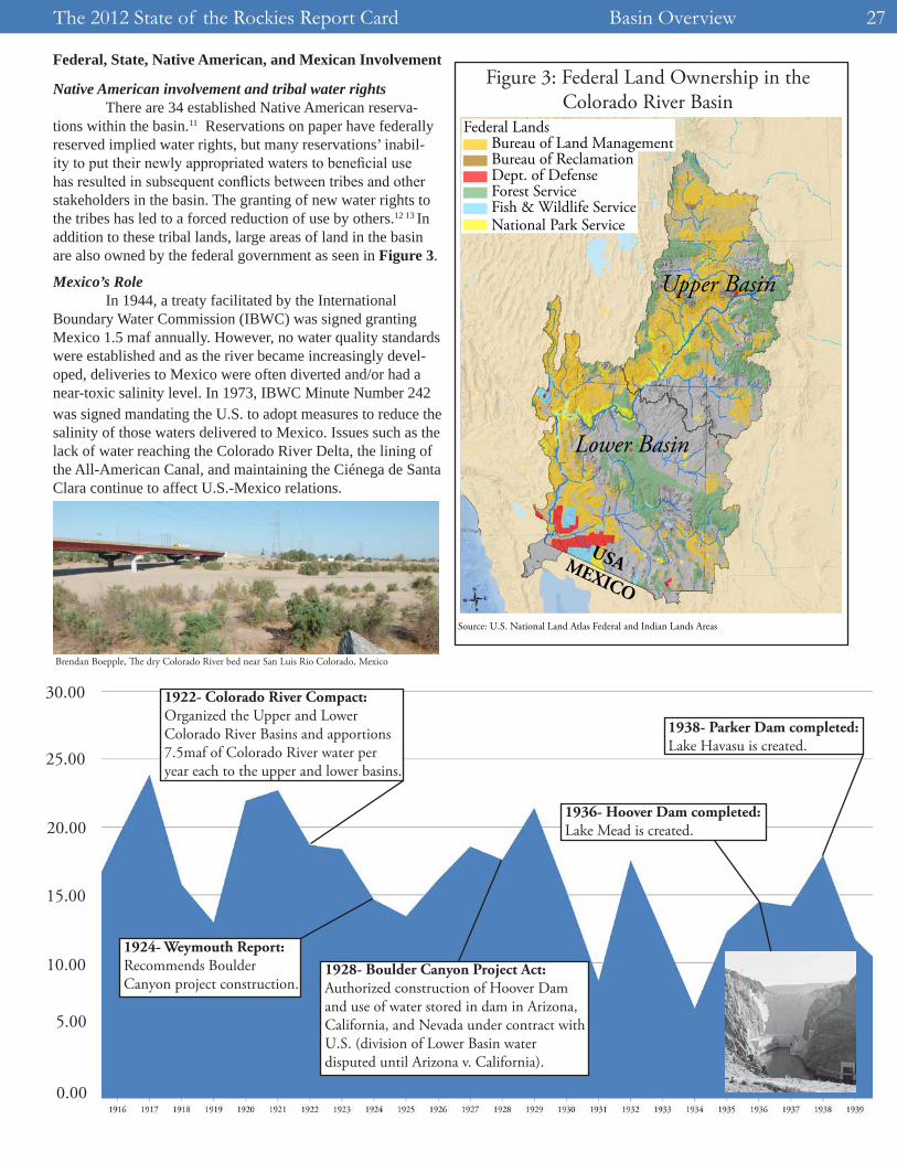
Native American involvement and tribal water rights There are 34 established Native American reserva-tions within the basin.11 Reservations on paper have federally reserved implied water rights, but many reservations’ inabil-ity to put their newly appropriated waters to beneficial use has resulted in subsequent conflicts between tribes and other stakeholders in the basin. The granting of new water rights to the tribes has led to a forced reduction of use by others.12 13 In addition to these tribal lands, large areas of land in the basin are also owned by the federal government as seen in Figure 3.
Mexico’s Role In 1944, a treaty facilitated by the International Boundary Water Commission (IBWC) was signed granting Mexico 1.5 maf annually. However, no water quality standards were established and as the river became increasingly devel-oped, deliveries to Mexico were often diverted and/or had a near-toxic salinity level. In 1973, IBWC Minute Number 242 was signed mandating the U.S. to adopt measures to reduce the salinity of those waters delivered to Mexico. Issues such as the lack of water reaching the Colorado River Delta, the lining of the All-American Canal, and maintaining the Ciénega de Santa Clara continue to affect U.S.-Mexico relations.
-
Federal LandsBureau of Land ManagementBureau of ReclamationDept. of DefenseForest ServiceFish & Wildlife ServiceNational Park Service
Upper Basin
Lower Basin
USAMEXICO
Figure 3: Federal Land Ownership in the Colorado River Basin
Brendan Boepple, The dry Colorado River bed near San Luis Rio Colorado, Mexico
0.00
5.00
10.00
15.00
20.00
25.00
30.00 1922- Colorado River Compact: Organized the Upper and Lower Colorado River Basins and apportions 7.5maf of Colorado River water per year each to the upper and lower basins.
1924- Weymouth Report: Recommends Boulder Canyon project construction.
1928- Boulder Canyon Project Act: Authorized construction of Hoover Dam and use of water stored in dam in Arizona, California, and Nevada under contract with U.S. (division of Lower Basin water disputed until Arizona v. California).
1936- Hoover Dam completed: Lake Mead is created.
1938- Parker Dam completed: Lake Havasu is created.
Source: U.S. National Land Atlas Federal and Indian Lands Areas
Basin Overview The 2012 State of the Rockies Report Card28
Uses of the Colorado River Nearly all water in the Colorado River has been put to “beneficial use” both inside and outside of the basin. Hu-man beneficial use does not generally include instream flows (leaving water in the river for environmental purposes), and has largely meant use for agriculture, municipal and indus-trial purposes, and recreation. Forty-five percent of Colorado River water is diverted out of the basin for both agricultural, municipal, and industrial use; many cities such as Denver, Los Angeles, and Salt Lake City already rely heavily on trans-basin diversions which disrupt surrounding ecosystems.14
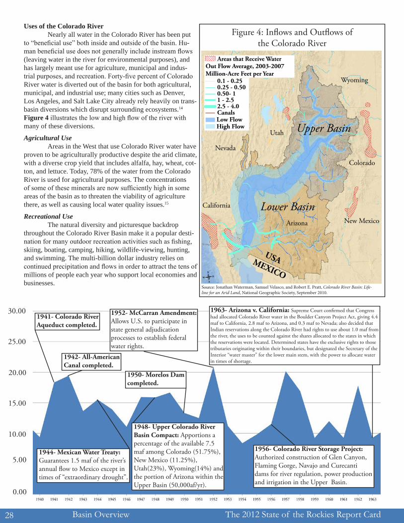
Figure 4 illustrates the low and high flow of the river with many of these diversions.
Agricultural Use Areas in the West that use Colorado River water have proven to be agriculturally productive despite the arid climate, with a diverse crop yield that includes alfalfa, hay, wheat, cot-ton, and lettuce. Today, 78% of the water from the Colorado River is used for agricultural purposes. The concentrations of some of these minerals are now sufficiently high in some areas of the basin as to threaten the viability of agriculture there, as well as causing local water quality issues.15
Recreational Use The natural diversity and picturesque backdrop throughout the Colorado River Basin make it a popular desti-nation for many outdoor recreation activities such as fishing, skiing, boating, camping, hiking, wildlife-viewing, hunting, and swimming. The multi-billion dollar industry relies on continued precipitation and flows in order to attract the tens of millions of people each year who support local economies and businesses.
Figure 4: Inflows and Outflows of the Colorado River
0.00
5.00
10.00
15.00
20.00
25.00
30.001941- Colorado River Aqueduct completed.
1942- All-American Canal completed.
1944- Mexican Water Treaty: Guarantees 1.5 maf of the river’s annual �ow to Mexico except in times of “extraordinary drought”.
1948- Upper Colorado River Basin Compact: Apportions a percentage of the available 7.5 maf among Colorado (51.75%), New Mexico (11.25%), Utah(23%), Wyoming(14%) and the portion of Arizona within the Upper Basin (50,000af/yr).
1950- Morelos Dam completed.
1952- McCarran Amendment: Allows U.S. to participate in state general adjudication processes to establish federal water rights.
1956- Colorado River Storage Project: Authorized construction of Glen Canyon, Flaming Gorge, Navajo and Curecanti dams for river regulation, power production and irrigation in the Upper Basin.
1963- Arizona v. California: Supreme Court con�rmed that Congress had allocated Colorado River water in the Boulder Canyon Project Act, giving 4.4 maf to California, 2.8 maf to Arizona, and 0.3 maf to Nevada; also decided that Indian reservations along the Colorado River had rights to use about 1.0 maf from the river, the uses to be counted against the shares allocated to the states in which the reservations were located. Determined states have the exclusive rights to those tributaries originating within their boundaries, but designated the Secretary of the Interior “water master” for the lower main stem, with the power to allocate water in times of shortage.
Wyoming
Utah
Nevada
California
New MexicoArizona
Colorado
-
Out Flow Average, 2003-2007Million-Acre Feet per Year
0.1 - 0.250.25 - 0.500.50- 11 - 2.52.5 - 4.0CanalsLow FlowHigh Flow
Areas that Receive Water
Upper Basin
Lower Basin
USAMEXICOSource: Jonathan Waterman, Samuel Velasco, and Robert E. Pratt, Colorado River Basin: Life-line for an Arid Land, National Geographic Society, September 2010.
The 2012 State of the Rockies Report Card Basin Overview 29
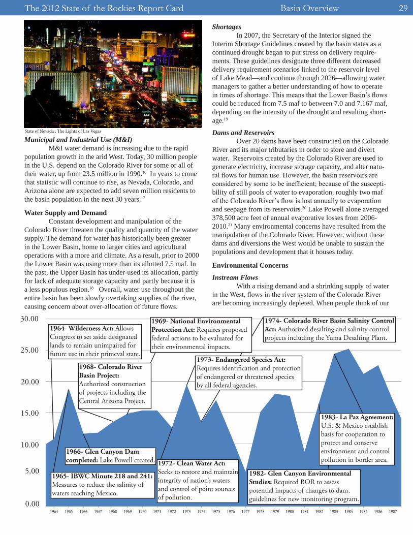
Municipal and Industrial Use (M&I) M&I water demand is increasing due to the rapid population growth in the arid West. Today, 30 million people in the U.S. depend on the Colorado River for some or all of their water, up from 23.5 million in 1990.16 In years to come that statistic will continue to rise, as Nevada, Colorado, and Arizona alone are expected to add seven million residents to the basin population in the next 30 years.17
Water Supply and Demand Constant development and manipulation of the Colorado River threaten the quality and quantity of the water supply. The demand for water has historically been greater in the Lower Basin, home to larger cities and agricultural operations with a more arid climate. As a result, prior to 2000 the Lower Basin was using more than its allotted 7.5 maf. In the past, the Upper Basin has under-used its allocation, partly for lack of adequate storage capacity and partly because it is a less populous region.18 Overall, water use throughout the entire basin has been slowly overtaking supplies of the river, causing concern about over-allocation of future flows.
Shortages In 2007, the Secretary of the Interior signed the Interim Shortage Guidelines created by the basin states as a continued drought began to put stress on delivery require-ments. These guidelines designate three different decreased delivery requirement scenarios linked to the reservoir levelof Lake Mead—and continue through 2026—allowing water managers to gather a better understanding of how to operate in times of shortage. This means that the Lower Basin’s flows could be reduced from 7.5 maf to between 7.0 and 7.167 maf, depending on the intensity of the drought and resulting short-age.19
Dams and Reservoirs Over 20 dams have been constructed on the Colorado River and its major tributaries in order to store and divert water. Reservoirs created by the Colorado River are used to generate electricity, increase storage capacity, and alter natu-ral flows for human use. However, the basin reservoirs are considered by some to be inefficient; because of the suscepti-bility of still pools of water to evaporation, roughly two maf of the Colorado River’s flow is lost annually to evaporation and seepage from its reservoirs.20 Lake Powell alone averaged 378,500 acre feet of annual evaporative losses from 2006-2010.21 Many environmental concerns have resulted from the manipulation of the Colorado River. However, without these dams and diversions the West would be unable to sustain the populations and development that it houses today.
Environmental Concerns
Instream Flows With a rising demand and a shrinking supply of water in the West, flows in the river system of the Colorado River are becoming increasingly depleted. When people think of our
State of Nevada , The Lights of Las Vegas
0.00
5.00
10.00
15.00
20.00
25.00
30.001964- Wilderness Act: Allows Congress to set aside designated lands to remain unimpaired for future use in their primeval state.
1966- Glen Canyon Dam completed: Lake Powell created.
1965- IBWC Minute 218 and 241: Measures to reduce the salinity of waters reaching Mexico.
1968- Colorado River Basin Project: Authorized construction of projects including the Central Arizona Project.
1969- National Environmental Protection Act: Requires proposed federal actions to be evaluated for their environmental impacts.
1972- Clean Water Act: Seeks to restore and maintain integrity of nation’s waters and control of point sources of pollution.
1973- Endangered Species Act: Requires identi�cation and protection of endangered or threatened species by all federal agencies.
1974- Colorado River Basin Salinity Control Act: Authorized desalting and salinity control projects including the Yuma Desalting Plant.
1982- Glen Canyon Environmental Studies: Required BOR to assess potential impacts of changes to dam, guidelines for new monitoring program.
1983- La Paz Agreement: U.S. & Mexico establish basis for cooperation to protect and conserve environment and control pollution in border area.
Basin Overview The 2012 State of the Rockies Report Card30
dwindling water supply, the immediate concern is usually re-stricted to the threat that it could have on human consumptive needs. Because the 1922 Colorado River Compact designated water rights strictly in terms of human use, no water was ever legally reserved for the health of the stream. Through later legislation and management guidelines, however, stakeholders have begun to acknowledge the environmental and economic threats that will arise if environmental flows are not protected.
Water Quality Contamination from agricultural and urban run-off, toxic leaching from mines, and the disruption of nutrient and sediment flow caused by dams are just a few examples of how current use and manipulation of the Colorado River can threaten ecosystems along the river through the deterioration of water quality.
Sediment Historically, the flow of sediment in the free flowing Colorado River facilitated the construction of natural sand-bars that served as the foundation for a diverse makeup of fish and wildlife. Many species evolved so that they could thrive in the sediment-rich environment of the free flowing river, a condition that no longer exists, as the construction of dams in the Colorado River Basin has disrupted the natural flow of sediment downstream.22 Dams cause sediment to build up in the reservoirs, thus also decreasing the storage capacity and making the dam system less efficient for water storage and electricity generation.23
Salinity In 1974, the Colorado River Basin Salinity Control Act was passed in an effort to control the salinity of the water being delivered to the Lower Basin and Mexico.24 Today, increased salinity levels are a major water quality concern
that threatens agricultural, municipal, and industrial users as well as the river’s fish and wildlife populations. The Colo-rado River’s salt content comes from a variety of sources; agriculture alone accounts for 37% of the river’s salt. Natural sources such as stream flow, reservoir storage, climatic condi-tions, and natural runoff account for about 50% of the river’s salt.25 Currently, $306-312 million per year are spent on salin-ity control, and the Bureau of Reclamation estimates that by the year 2025 that number will increase to $471 million per year if no additional projects are put in place.26
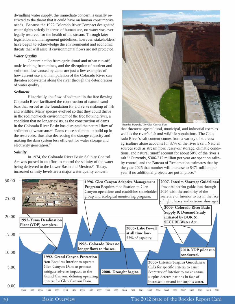
Brendan Boepple, The Glen Canyon Dam
0.00
5.00
10.00
15.00
20.00
25.00
30.00
1992- Grand Canyon Protection Act: Requires Interior to operate Glen Canyon Dam to protect/mitigate adverse impacts to the Grand Canyon, de�ning operating criteria for Glen Canyon Dam.
1992- Yuma Desalination Plant (YDP) complete.
1996- Glen Canyon Adaptive Management Program: Requires modi�cation to Glen Canyon operations and establishes stakeholder group and ecological monitoring program.
1998- Colorado River no longer �ows to the sea.
2000- Drought begins.
2003- Interim Surplus Guidelines: Calls for speci�c criteria to assist Secretary of Interior to make annual surplus determinations in face of increased demand for surplus water.
2005- Lake Powell at all time low- 33% of capacity.
2007- Interim Shortage Guidelines: Provides interim guidelines through 2026 with the authority of the Secretary of Interior to act in the face of light, heavy and extreme shortages.
2009- Colorado River Basin Supply & Demand Study initiated by BOR & SECURE Water Act.
2010- YDP pilot run conducted.
The 2012 State of the Rockies Report Card Basin Overview 31
Invasive and Endangered Species Five percent of the Colorado River’s native fauna are already extinct and 32% are currently endangered. Of the 14 native fish in the Colorado River, four species are currently endangered. They are threatened by stream flow regulation, habitat modification, poor water quality, and competition with nonnative species. If they are not addressed, these problems will continue to worsen due to a decrease in essential re-sources and increased interspecies competition. In addition to the ecological importance of species and habitat preservation, there are also legal requirements such as the Threatened and Endangered Species Act that mandate conservation.
Past, Present, and Future Climate The climate of the Colorado River Basin has long been defined by high variability in both precipitation and temperature, but the constant nature of the system is a cold and humid climate in the relatively small headwaters regions where snowpack contributes to streamflow, but a semi-arid and arid climate throughout the rest of the basin. The average temperature in the basin is expected to increase; The SE-CURE Water Report noted a 2.16°F (1.2°C) increase in basin-wide temperatures in the 20th century. The Lower Basin alone saw a 3.06°F (1.7°C) increase, due to the dryer and hotter climate of the lower states. Findings also predict a 6-7°F (3.3-3.9°C) increase in Upper Basin average temperatures over the course of the 21st century, coupled with a 5-6°F (2.8-3.3°C) increase in Lower Basin temperatures over the same period.27
Impacts on Water Supply Nearly all studies agree that the temperature increas-es predicted for a changing climate have a large probability of further reducing the water supply of the Colorado River. The Bureau of Reclamation has projected future changes in aver-age annual runoff using an ensemble of 112 climate model runs; the ensemble mean is an 8.5% decrease by 2050. The climatic explanation for this flow reduction lies in a dimin-ished accumulation of high elevation snow during the cool season due to higher average temperatures, which translates into a smaller snowpack and less snowmelt to sustain runoff during the warm season.28 Expected changes in precipitation in the range of a 2.1% increase and a 1.6% decrease in the up-per and lower basins, respectively, may also impact the supply of the river.
Impacts on Ecosystems Increases in temperature will create additional stress on already sensitive fisheries, creating both ecological and economic strain in the region. A warmer climate also pro-vides an optimal habitat for some invasive species, which will continue to threaten native flora and fauna. The hotter temperatures will likely be accompanied by increased wildfire potential and subsequent habitat destruction.29
Conclusion These issues are individually complex, and their relationships with one another are not fully understood. If ef-forts are not made to reach a careful balance between supply, demand, and competing uses, however, the negative impacts
of each issue will become amplified, leading to drastic changes in the state of the Colorado River. While most matters of the river are currently in the hands of powerful stakeholders and politicians, what happens in the next decade largely dictates the future of the river for the next generation and beyond. It is time for the younger generation to become informed, involved, and engaged in making clear its desires, expectations, and solutions for the future of the Colorado River, before it is too late.
1Jonathan Waterman, Samuel Velasco, and Robert E. Pratt, Colorado River Basin: Lifeline for an Arid Land, National Geographic Society, September 2010, http://maps.nationalgeographic.com/maps/print-collection/colorado-basin1-map.html.2Dale Pontius and SWCA, Inc. Environmental Consultants, “Colorado River Basin Study: Final Report,” Report to the Western Water Policy Review Advisory Commission, 1997, 13.3Jonathan Waterman, Samuel Velasco, and Robert E. Pratt, Colorado River Basin: Lifeline for an Arid Land, http://maps.nationalgeographic.com/maps/print-collection/colorado-basin1-map.html.4Dale Pontius and SWCA, Inc. Environmental Consultants, “Colorado River Basin Study: Final Report,” 2.5Ibid., 5.6Ibid.7Colorado River Compact, 1922. Art. III Sec. (b). 8Dale Pontius and SWCA, Inc. Environmental Consultants, “Colorado River Basin Study: Final Report,” 15.9Ibid., 21.10Douglas Kenney, “An Introduction to Key Facts and Issues Regarding the Allocation and Use of the Colorado River” (conference primer for Hard Times on the Colorado River: Growth, Drought, and the Future of the Compact, Natural Resources Law Center, University of Colorado at Boulder, June 8-10, 2005), p. 9. 11Dale Pontius and SWCA, Inc. Environmental Consultants, “Colorado River Basin Study: Final Report,” 30.12Congressional Budget Office, Water Use Conflicts in the West: Implications of Reforming the Bureau of Reclamation’s Water Supply Policies, accessed January 24, 2012, http://www.cbo.gov/doc.cfm?index=46&type=0&sequence=3#N_7_ .13Jonathan Waterman, Samuel Velasco, and Robert E. Pratt, Colorado River Basin: Lifeline for an Arid Land, http://maps.nationalgeographic.com/maps/print-collection/colorado-basin1-map.html.14Western Resource Advocates, “Smart Water: A Comparative Study of Urban Water Use Ef-ficiency Across the Southwest,” December 2003, p. 9.15Jonathan Waterman, Samuel Velasco, and Robert E. Pratt, Colorado River Basin: Lifeline for an Arid Land, http://maps.nationalgeographic.com/maps/print-collection/colorado-basin1-map.html.16Michael J. Cohen, “Municipal Deliveries of Colorado River Basin Water,” Pacific Institute, June 2011, p. 36.17Western Resource Advocates, “Smart Water: A Comparative Study of Urban Water Use Ef-ficiency Across the Southwest,” p. 9.18US Bureau of Reclamation, “2. Basin Report: Colorado.” In SECURE Water Act Section 9503(c): Reclamation Climate Change and Water, Report to Congress, 2011, 17-40. 19Dale Pontius and SWCA, Inc. Environmental Consultants, “Colorado River Basin Study: Final Report,” 22.20US Bureau of Reclamation, “Colorado River System Consumptive Uses and Losses Report 1996-2000,” accessed August 10, 2011, http://www.usbr.gov/uc/library/envdocs/reports/crs/pdfs/crs962000.pdf 21US Bureau of Reclamation, “Colorado River System Consumptive Uses and Losses Report 2006-2010,” accessed July 13, 2011, http://www.usbr.gov/uc/library/envdocs/reports/crs/pdfs/cul2006-2010prov.pdf.22Glen Canyon Dam Adaptive Management Program, “Sediment and River Sand Bars in the Grand Canyon,” accessed June 26, 2011, http://www.gcdamp.gov/keyresc/sediment.html.23International Rivers, “Sedimentation Problems with Dams,” accessed June 26, 2011, http://www.internationalrivers.org/node/1476.24US Bureau of Reclamation, “Colorado River Basin Salinity Control Act,” accessed June 26, 2011, http://www.usbr.gov/uc/progact/salinity/.25US Bureau of Reclamation, “Quality of Water: Colorado River Basin Progress Report No. 22,” 2005, p. 13. 26Ibid., p. 23.27US Bureau of Reclamation, “2. Basin Report: Colorado,” p. 17-40. 28Ibid.29Ibid.