The Coast: Beaches and Shoreline Processes Coastal region constantly changes Coastal region...
32
The Coast: The Coast: Beaches and Shoreline Beaches and Shoreline Processes Processes Coastal region constantly changes Coastal region constantly changes Primarily due to waves Primarily due to waves Erosion Erosion Deposition Deposition Many people live in coastal Many people live in coastal regions regions 80% of people in U.S. live within 80% of people in U.S. live within easy access of coast easy access of coast
-
Upload
harriet-curtis -
Category
Documents
-
view
217 -
download
0
Transcript of The Coast: Beaches and Shoreline Processes Coastal region constantly changes Coastal region...

The Coast: The Coast: Beaches and Shoreline Beaches and Shoreline
ProcessesProcesses
Coastal region constantly changesCoastal region constantly changesPrimarily due to wavesPrimarily due to waves
ErosionErosionDepositionDeposition
Many people live in coastal regionsMany people live in coastal regions80% of people in U.S. live within easy 80% of people in U.S. live within easy access of coastaccess of coast

Coastal regionsCoastal regions
CoastCoast = extends inland from shore as far as ocean-related features can = extends inland from shore as far as ocean-related features can be foundbe foundCoastlineCoastline = marks boundary between shore and coast = marks boundary between shore and coast
BeachBeach = deposit of sediment along the shore area (active coastal area); = deposit of sediment along the shore area (active coastal area); consists of wave-worked sediment that moves along the wave-cut bench consists of wave-worked sediment that moves along the wave-cut bench (flat, wave-eroded surface)(flat, wave-eroded surface)
Beach faceBeach face = wet, sloping surface between = wet, sloping surface between bermberm and shoreline (aka and shoreline (aka “low tide terrace”)“low tide terrace”)BermBerm = dry, gently sloping region at the foot of cliffs or dunes = dry, gently sloping region at the foot of cliffs or dunes
ShoreShore = between low tide line and the highest elevation on land that is = between low tide line and the highest elevation on land that is affected by storm waves (coastline)affected by storm waves (coastline)ShorelineShoreline = water’s edge; migrates with tides = water’s edge; migrates with tides
foreshoreforeshore = between low tide line and high tide line = between low tide line and high tide line backshorebackshore = above high tide line (covered with water only during = above high tide line (covered with water only during storms)storms)
NearshoreNearshore = between low tide line and low tide breaker line; above = between low tide line and low tide breaker line; above wave basewave base
longshore bar/longshore troughlongshore bar/longshore troughOffshoreOffshore = deeper water; below wave base = deeper water; below wave base
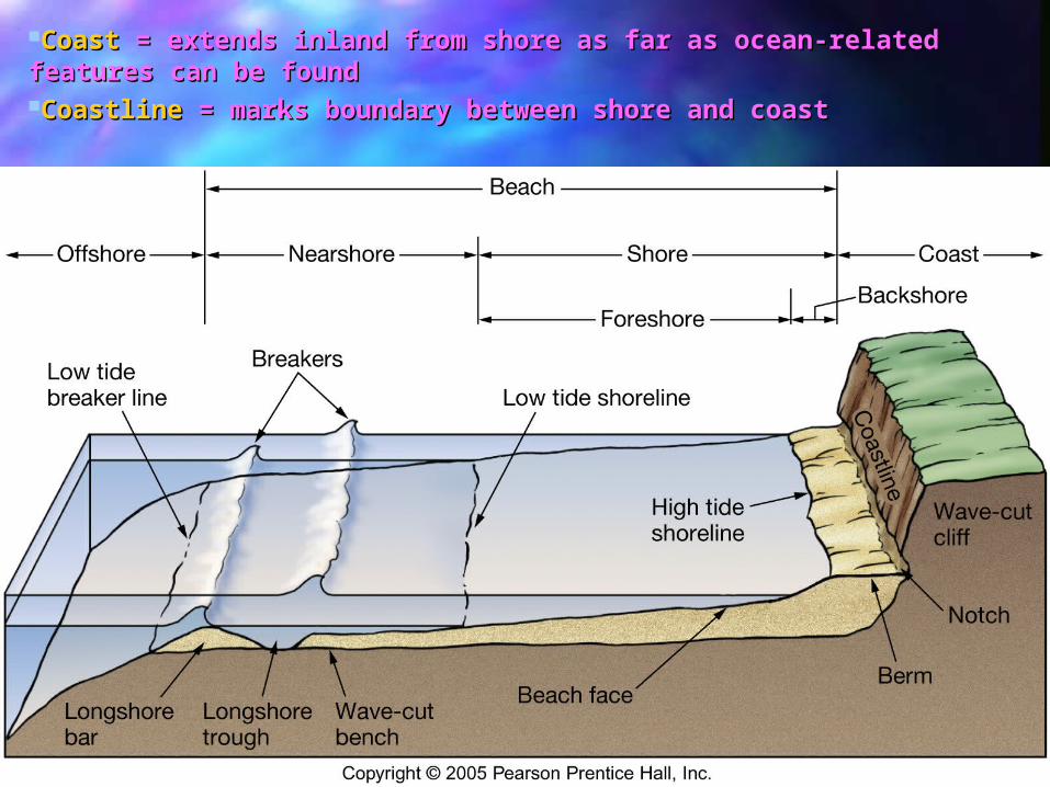
CoastCoast = extends inland from shore as far as ocean-related = extends inland from shore as far as ocean-related features can be foundfeatures can be foundCoastlineCoastline = marks boundary between shore and coast = marks boundary between shore and coast

BeachBeach = deposit of sediment along the shore area (active = deposit of sediment along the shore area (active coastal area); consists of wave-worked sediment that moves coastal area); consists of wave-worked sediment that moves along the wave-cut bench (flat, wave-eroded surface)along the wave-cut bench (flat, wave-eroded surface)
Beach faceBeach face = wet, sloping surface between = wet, sloping surface between bermberm and and shoreline (aka “low tide terrace”)shoreline (aka “low tide terrace”)BermBerm = dry, gently sloping region at the foot of cliffs or = dry, gently sloping region at the foot of cliffs or dunesdunes

ShoreShore = between low tide line and the highest elevation on land = between low tide line and the highest elevation on land that is affected by storm waves (coastline)that is affected by storm waves (coastline)ShorelineShoreline = water’s edge; migrates with tides = water’s edge; migrates with tides
foreshoreforeshore = between low tide line and high tide line (aka = between low tide line and high tide line (aka “intertidal” or “littoral” zone)“intertidal” or “littoral” zone) backshorebackshore = above high tide line (covered with water only = above high tide line (covered with water only during storms)during storms)
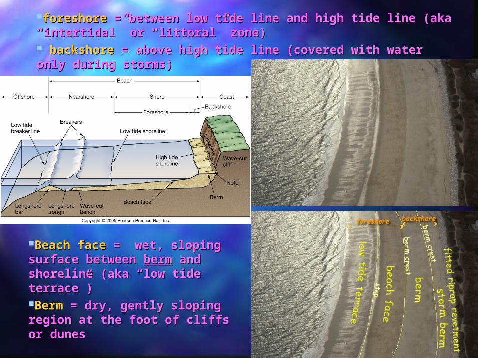
foreshoreforeshore = between low tide line and high tide line (aka = between low tide line and high tide line (aka “intertidal” or “littoral” zone)“intertidal” or “littoral” zone) backshorebackshore = above high tide line (covered with water only = above high tide line (covered with water only during storms)during storms)
Beach faceBeach face = wet, sloping = wet, sloping surface between surface between bermberm and and shoreline (aka “low tide shoreline (aka “low tide terrace”)terrace”)BermBerm = dry, gently sloping = dry, gently sloping region at the foot of cliffs or region at the foot of cliffs or dunesdunes

NearshoreNearshore = between low tide line and low tide breaker line; = between low tide line and low tide breaker line; above wave baseabove wave base
longshore bar, longshore troughlongshore bar, longshore troughOffshoreOffshore = deeper water; below wave base; beyond breakers = deeper water; below wave base; beyond breakers

Locally available materialLocally available materialMay be coarse or fine:May be coarse or fine:
Boulders, cobbles from local cliffsBoulders, cobbles from local cliffsSand, mud from riversSand, mud from rivers
Significant biologic material at tropical beachesSignificant biologic material at tropical beachesExample, Coral reef material, shell fragmentsExample, Coral reef material, shell fragments
LithologicLithologic = eroded from cliffs or deposited by rivers; volcanic = eroded from cliffs or deposited by rivers; volcanic materialmaterial
Gravel, sand, silt, clayGravel, sand, silt, clayBiogenicBiogenic = shell fragments; coral debris = shell fragments; coral debris
Beach material is in transit along the shorelineBeach material is in transit along the shoreline
Beach CompositionBeach Composition

Perpendicular to shoreline (toward and away)Perpendicular to shoreline (toward and away)Swash (brings in sand) and backwash (takes sand Swash (brings in sand) and backwash (takes sand away)away)
Parallel to shoreline (up-coast or down-coastParallel to shoreline (up-coast or down-coastLongshore current (moves sand along beach)Longshore current (moves sand along beach)
Sand movement along Sand movement along beachbeach
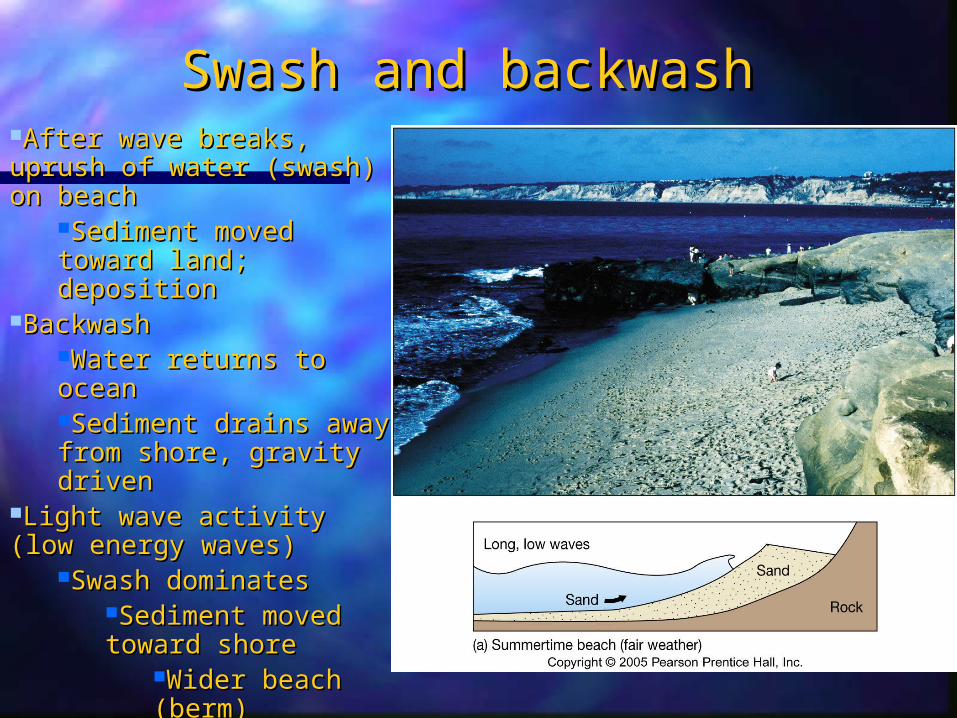
Swash and backwashSwash and backwashAfter wave breaks, uprush After wave breaks, uprush of water (swash) on beachof water (swash) on beach
Sediment moved Sediment moved toward land; depositiontoward land; deposition
BackwashBackwashWater returns to oceanWater returns to oceanSediment drains away Sediment drains away from shore, gravity from shore, gravity drivendriven
Light wave activity (low Light wave activity (low energy waves)energy waves)
Swash dominatesSwash dominatesSediment moved Sediment moved toward shoretoward shore
Wider beach Wider beach (berm)(berm)
Fair weather: Summertime Fair weather: Summertime beachbeach

Swash and backwashSwash and backwash
Heavy wave activityHeavy wave activityHigh energy wavesHigh energy wavesBackwash dominatesBackwash dominatesSediment moved away Sediment moved away from shore; erosionfrom shore; erosionNarrower beachNarrower beach
Sand forms offshore sand Sand forms offshore sand barsbarsStormy weatherStormy weatherWintertime beachWintertime beach

Wave Activity andWave Activity andBeach CharacteristicsBeach Characteristics

A-Long-the-Shore MotionA-Long-the-Shore MotionMillions of tons of sediment moved Millions of tons of sediment moved yearlyyearlyDirection of transport changes due to Direction of transport changes due to wave approachwave approachIn general, sediment is transported In general, sediment is transported southwardsouthward along Atlantic and Pacific along Atlantic and Pacific coasts of U.S.coasts of U.S.
Longshore current = zig-zag Longshore current = zig-zag movement of watermovement of water
4 km/hr (2.5 mph)4 km/hr (2.5 mph)Faster if:Faster if:
Steeper beachSteeper beachHigher angle of Higher angle of incidence of wavesincidence of wavesGreater wave heightsGreater wave heights
Longshore drift (longshore Longshore drift (longshore transport) = zig-zag transport) = zig-zag movement of sediment due to movement of sediment due to longshore currentlongshore current
Net movement = Net movement = downcurrentdowncurrentOnly within surf zone Only within surf zone (beach), where waves (beach), where waves touch bottom and refract touch bottom and refract (d <L/2)(d <L/2)

Shoreline FeaturesShoreline Features
Erosional ShoresErosional ShoresWell-developed cliffsWell-developed cliffsTectonic upliftTectonic uplift
Pacific coastPacific coast
Depositional ShoresDepositional ShoresSand deposits and Sand deposits and offshore barrier offshore barrier islandsislandsSlow subsidenceSlow subsidence
SE Atlantic SE Atlantic coastcoastGulf coastGulf coast

Erosional ShoresErosional Shores
Wave-cut sea cliffsWave-cut sea cliffs
Wave-cut benchWave-cut bench
Headlands/covesHeadlands/coves
Sea cavesSea caves
Sea arches/sea stacksSea arches/sea stacks
Marine terracesMarine terraces
BlowholesBlowholes
Wave erosion increases withWave erosion increases withMore shore exposed to open oceanMore shore exposed to open oceanSmaller tidal rangeSmaller tidal rangeWeaker bedrockWeaker bedrock

Erosional Erosional ShoresShores
View of the marine terrace just south of Goat Rock. View of the marine terrace just south of Goat Rock. "Perched on the top of the terrace is a large rock, "Perched on the top of the terrace is a large rock, floating like a ship on the level surface." Below the floating like a ship on the level surface." Below the terrace, a modern-day wave cut platform and sea stacks terrace, a modern-day wave cut platform and sea stacks are being formed by the pounding surf. Photo copyright are being formed by the pounding surf. Photo copyright Barrie Rokeach 2001Barrie Rokeach 2001
Wave-cut sea cliffsWave-cut sea cliffs
Wave-cut benchWave-cut bench
Headlands/covesHeadlands/coves
Sea arches/sea Sea arches/sea stacksstacks
Marine terracesMarine terraces

Depositional ShoresDepositional Shores
BeachBeachSpitSpitBay barrier/bay-mouth Bay barrier/bay-mouth barbarTomboloTomboloBarrier islandBarrier island
Long, narrow offshore Long, narrow offshore deposits parallel to shoredeposits parallel to shoreMost developed due to Most developed due to rise of sea level about rise of sea level about 18,000 years ago18,000 years agoCommon along East and Common along East and Gulf coasts of U.S.Gulf coasts of U.S.Protect mainland from Protect mainland from high wave activityhigh wave activity
DeltaDeltaBeach compartmentsBeach compartments
Primarily deposited by longshore driftPrimarily deposited by longshore drift

Depositional ShoresDepositional Shores

Barrier IslandsBarrier IslandsDefense against rising sea level Defense against rising sea level and high-energy storm wavesand high-energy storm waves
a)a) NC Outer NC Outer BanksBanks
b)b) South TX South TX coast coast (Padre (Padre Island, etc.)Island, etc.)
c)c) Tom’s Tom’s River, NJRiver, NJ
Many developed during global Many developed during global rise in sea level associated with rise in sea level associated with the last Ice Age ~18,000 years the last Ice Age ~18,000 years ago.ago.

Barrier IslandsBarrier Islands
ocean beach (summer vs. winter)ocean beach (summer vs. winter)
dunes (wind; stabilized by grasses; protect lagoon during storms)dunes (wind; stabilized by grasses; protect lagoon during storms)
barrier flat (sand blown further during storms; bio-succession)barrier flat (sand blown further during storms; bio-succession)
high salt marsh (to high spring-tide line)high salt marsh (to high spring-tide line)
low salt marsh (mean sea level to high neap-tide line; bio-productive)low salt marsh (mean sea level to high neap-tide line; bio-productive)
lagoonlagoon
New marshland created by overwash; island migratesNew marshland created by overwash; island migrates

DeltasDeltasStream empties into oceanStream empties into ocean
Fan-shaped deposit of sedimentFan-shaped deposit of sediment
Distributary channelsDistributary channels
MS River delta, Nile River deltaMS River delta, Nile River delta
SAC-San Joaquin River deltaSAC-San Joaquin River delta

Sacramento-San Joaquin River Sacramento-San Joaquin River DeltaDelta

Beach CompartmentsBeach Compartments3 components:3 components:
riversrivers & coastal erosion = & coastal erosion = sourcesource of sediment to of sediment to beachesbeaches
beachbeach = sand in motion due to = sand in motion due to longshore transportlongshore transport
submarine canyonssubmarine canyons = = sinksink where sediment drains away where sediment drains away from beachfrom beach
Upstream = narrow, rocky beachUpstream = narrow, rocky beachDownstream = wide, sandy beachDownstream = wide, sandy beach
Beach StarvationBeach Starvation
Human activities alter balance Human activities alter balance of natural system in beach of natural system in beach compartments, e.g., dams compartments, e.g., dams deprives beach of source deprives beach of source material.material.
Characteristic of depositional shores.Characteristic of depositional shores.

ShorelinesShorelinesEmerging shorelines = land rises or sea level dropsEmerging shorelines = land rises or sea level drops
marine terraces (exposed wave-cut benches), ancient sea cliffsmarine terraces (exposed wave-cut benches), ancient sea cliffs
stranded beach depositsstranded beach deposits
Submerging shorelines = land subsides or sea level risesSubmerging shorelines = land subsides or sea level rises
drowned beachesdrowned beaches
submerged dune topographysubmerged dune topography
drowned river valleysdrowned river valleys

Sea Level ChangesSea Level Changes
Sea level dropped globally by about 120 m (400 ft) as the last glacial Sea level dropped globally by about 120 m (400 ft) as the last glacial advance removed water from the oceans and transferred it to glaciers on advance removed water from the oceans and transferred it to glaciers on land. About 18,000 years ago, sea level began to rise as the glaciers land. About 18,000 years ago, sea level began to rise as the glaciers melted and water returned to the seas.melted and water returned to the seas.
Tectonic movementsTectonic movementsuplift or subsidenceuplift or subsidencee.g., Pacific coaste.g., Pacific coast
Isostatic adjustmentIsostatic adjustmentsubsidence or reboundsubsidence or rebounde.g., Hudson Bay, Gulf of e.g., Hudson Bay, Gulf of Bothnia (900 ft)Bothnia (900 ft)
Eustatic changesEustatic changesseawater volume or ocean seawater volume or ocean capacitycapacitye.g., seafloor spreading e.g., seafloor spreading rates, ice agesrates, ice ages

Euastatic Sea Level ChangesEuastatic Sea Level Changes
Measured relative sea level Measured relative sea level rise at NYC.rise at NYC.
Tide-gauge data from NYC Tide-gauge data from NYC show in increase in sea show in increase in sea
level of 40 cm (16 in) since level of 40 cm (16 in) since 1850. While some of this 1850. While some of this
rise is due to local effects, rise is due to local effects, most is due to thermal most is due to thermal
expansion of warmer expansion of warmer ocean water and the ocean water and the
retreat of small ice caps retreat of small ice caps and glaciers.and glaciers.

Factors affecting U.S. coastsFactors affecting U.S. coasts
Map shows coastal bedrock type, mean spring-tide range, degree of Map shows coastal bedrock type, mean spring-tide range, degree of exposure, and average direction of longshore drift. Map also shows average exposure, and average direction of longshore drift. Map also shows average rate of erosion (-) or deposition (+) between 1979 and 1983 in m/yr.rate of erosion (-) or deposition (+) between 1979 and 1983 in m/yr.

Atlantic Atlantic CoastCoast
In general, a submerging coastline In general, a submerging coastline with erosion dominant (avg. 0.8 m/yr with erosion dominant (avg. 0.8 m/yr or 2.6 ft/yr).or 2.6 ft/yr).
BUT:BUT:Open exposure to storm waves; Open exposure to storm waves; barrier islands protect some areas.barrier islands protect some areas.
Tide ranges from <1 m (Florida) to >2 Tide ranges from <1 m (Florida) to >2 m (Maine).m (Maine).
Bedrock varies; affects shoreline Bedrock varies; affects shoreline features.features.
Glacial features from NY northward Glacial features from NY northward and rising sea level since Ice Age; and rising sea level since Ice Age; rebound in Maine.rebound in Maine.

Pacific Pacific CoastCoast In general, an emerging coastline; In general, an emerging coastline;
avg. erosion (0.005 m/yr).avg. erosion (0.005 m/yr).
Open exposure to storm waves.Open exposure to storm waves.
Tectonic uplift.Tectonic uplift.
Tide ranges between 1-2 mTide ranges between 1-2 m
Bedrock mostly sedimentary; easy to Bedrock mostly sedimentary; easy to erode.erode.
Beach starvation.Beach starvation.

Hard Hard StabilizationStabilization
Groins/groin fields - perpendicular to Groins/groin fields - perpendicular to shorelineshorelineJetties - perpendicular to shoreline to protect Jetties - perpendicular to shoreline to protect harborharborBreakwaters - parallel shorelineBreakwaters - parallel shorelineSeawalls - landward of bermSeawalls - landward of berm

Hard Hard StabilizationStabilization
19311949

Seawalls and Seawalls and beachesbeaches
When a seawall is build along a beach to When a seawall is build along a beach to protect property:protect property:
a)a) A large storm can remove the beach A large storm can remove the beach from the seaward side of the wall and from the seaward side of the wall and steepen its seaward slope.steepen its seaward slope.
b)b) Eventually the wall is undermined and Eventually the wall is undermined and falls into the sea.falls into the sea.
c)c) The property is lost. . .The property is lost. . .
d)d) . . .as the oversteepened beach slope . . .as the oversteepened beach slope advances landward in its effort to advances landward in its effort to reestablish a natural slope angle.reestablish a natural slope angle.
Replenishment (beach nourishment)Replenishment (beach nourishment)RelocationRelocation