The Burgess Community Bicycle and Pedestrian Plan
45
Horry County Bicycle and Pedestrian Plan 1 Horry County Planning and Zoning Department The Burgess Community Bicycle and Pedestrian Plan
-
Upload
truongtuyen -
Category
Documents
-
view
220 -
download
4
Transcript of The Burgess Community Bicycle and Pedestrian Plan

HorryCountyBicycleandPedestrianPlan
1
Horry County Planning and Zoning Department
TheBurgessCommunityBicycleandPedestrianPlan

Horry County Bicycle and Pedestrian Plan 2015
INTRODUCTIONLocated on the coastal plain of northeastern SouthCarolina, Horry County has experienced significantgrowth over the past four decades. The Burgesscommunity is an unincorporated area in HorryCounty, located on the southern boundary betweenHorryandGeorgetowncounties. Thecommunity isapproximately28squaremilesinareaandisflankedonthewestbytheWaccamawRiverandtheeastbyUSHighway17Bypass.Thenorthernboundaryisanamalgamationofpropertieswithnocleardelineation,separate from neighboring Socastee. A communitymapisavailableintheMapssectionofthisPlan.TheBurgessCommunityhasexperiencedsignificantpopulationgrowthoverthelastdecades.Since1990,the population of Burgess has increased by 633%.According to the 2010 Census, the BurgessCommunityhas apopulationof24,923persons. In2000, thepopulation inBurgesswas12,103,and in1990itwasonly3,396.Thetotalpopulationincreasebetween 1990 and 2010 for Burgess was 21,527people.InMay of 2012, Horry County Council adopted theBurgessAreaPlan. Areaplansaredesignedtogivemembers of the community the opportunity todiscuss the direction that growth and developmentshould take in their area. Area plans also allowcitizenstomakerecommendationstoCountyCouncil
on how questions regarding development in theircommunityshouldbeapproached.Areaplanscanbeused to cover elements of the Horry CountyComprehensivePlaningreaterdetail.Theycanalsoaddress issues that community members feel areimportant which are not discussed in theComprehensivePlan.SeveralrecommendationsestablishedintheBurgessArea Plan identified the community’s desire toincrease pedestrian and bicycle infrastructure.Several implementation strategies were developedandarelistedbelow: Encouragetheconstructionofsidewalksandbike
pathsalongnewlyconstructedroadways. Identify and enhance important pedestrian
routes. Identifygapsintheexistingsidewalknetworkand
wherereasonable,fillthegaps. Includepedestrian level traffic signalingdevices
andhigh‐visibilitycrosswalksatallintersectionsfrequentedbypedestriantraffic.
Developbicycleroutesconnectinggreenandopenspaces, commercial areas, schools, communitycenters, parks and other Burgess Areadestinations.
Itistheintentofthisdocumenttoestablishaplanforpedestrian and cycle infrastructure in the BurgessCommunityasenvisionedintheAreaPlan.
The Burgess C
omm
unity
danfordj
Text Box
B-1

Horry County Bicycle and Pedestrian Plan 2015
EXISTINGCONDITIONSThe existing conditions, as determined throughcommunitymeetings, community surveys, planningstudies, and on site analysis, indicate Burgess is acommunitythatwouldbenefitfromacomprehensivecycle and pedestrian network. The ExistingConditionsbelowsetthestageforRecommendationslaterinthisPlan.A. RoadNetworkExpansionVehicularvolumeandcongestionarecurrentlybeingaddressed through theRiding on a Penny (RIDE II)localoptionsalestax.Specifically,thecommunitywillhave access to Highway 31via an interchange withHighway707.Thisprojectwillbring6‐lanesofreliefto citizens on the south end looking to access theregional transportation network. Getting to thebeach,GardenCity, SurfsideBeach, andcommercialareas along Highway 17 Bypass and Highway 17BusinesswillbeeasieroncethegradeseparationatHolmestown Road and Highway 17 Bypass iscomplete.ThewideningofHighway707toa5‐lanecrosssectionwithsidewalkswillhaveamajorimpactthroughout the community once complete. Theseprojects are a significant investment in thetransportation system that will ease congestion,reinforce traffic safety, increase land values, andimprove quality of life for citizens of the Burgesscommunity.
B. LimitedchoicesforcyclistandpedestrianThe challenge of a multi‐modal transportationnetworkwillpersistabsentthisPlan,astheonlynon‐vehicular infrastructure included in the above roadprojects are sidewalks along the entirety of theHighway 707 corridor. The sidewalks will beconstructedonbothsidesofHighway707,addingintotalover15.5miles(totalofbothsidesofHighway707measured from the county line to intersectionwithBigBlockRoad)ofsidewalk. Currentsidewalkinfrastructure is limited to neighborhoods mostly,althoughcommunitysidewalksexistinPrinceCreekasaresultoftheMasterPlanforthatcommunity.Amajority of Burgess citizens have access to atransportation network dominated by theautomobile.C. PhysicalImpedimentsDuring the Fall 2014 semester, students at CoastalCarolinaUniversity(CCU)enrolledinanIntroductionto Planning course gathered data on existingconditions in the Burgess Community. Roadsevaluated included Bay, Freewoods, Holmestown,Longwood, McDowell Shortcut, Salem, Scipio andTournament. Additionally, thestudents inventoriedconditions around the schools in Burgess. Theinventory indicates pedestrian and cyclinginfrastructure faces an endemic problem; roads inBurgess are lined by ditches in close proximity totravellanes. Theseditchesareanimportantpartof
The Burgess C
omm
unity
danfordj
Text Box
B-2

Horry County Bicycle and Pedestrian Plan 2015
regional infrastructure in that they conveystormwater.
However,theypresentamajorchallengeintermsofconstructingsidewalks,cyclelanes,ormulti‐purposepaths throughoutBurgess. Asignificantcomponentof construction costs for any multi‐modal projectutilizingexistingright‐of‐wayinBurgessisaresultofaddressingtheseroadsideditches.Inmanyinstancesthese ditcheswill require closure, that is, theywillneedtobepiped.Fillmaterialandpipes,alongwithre‐gradingroadshoulders,accountfor,insomecases,halfoftheoverallprojectcostsidentifiedinthisPlan.Cost will be a significant challenge to overcome
movingforwardastheprojectshereindonothaveadedicatedfundingmechanism.D. SafetyTheCCUstudentreportdetailedtheissueofsafety,orthe perceived lack thereof. The studentsmet withadministrationatthe4schoolsinBurgess(St.JamesHigh,St.JamesMiddle,St.JamesElementary,BurgessElementary). The report notes that St. JamesElementaryandMiddlearebothpartnersistheSouthCarolina Safe Routes to School program. However,administration at these two campuses are againstimprovements to pedestrian and cyclinginfrastructureduetosafetyconcerns.Currenttrafficconditions at these campuses during peak travelhours(drop‐offandpick‐up)arehectic.Safetyisthefirst priority when planning for and developing amulti‐modaltransportationsystem.Crosswalksandpedestrian signals are part of the improvementsherein, and separation frommotorized travel laneshasbeentakenintoaccounttoeasesafetyconcerns.E. CommunityTopicalSurveyMultiplecommunitymeetingswereheldintheearlymonthsoftheplanningprocess. AttheMarch2015meeting of the Greater Burgess CommunityAssociation, residentsweregivenanopportunity tocompleteatopicalsurvey.Thesurveywasavailable
Figure1:CCUStudentscapturingfielddata
The Burgess C
omm
unity
danfordj
Text Box
B-3

Horry County Bicycle and Pedestrian Plan 2015
inpersonatthemeetingandonlinefortwoweeks.Atopical surveyasks a seriesofquestionsona giventopic; in this case bicycle and pedestrianimprovementsaswellasgeneralquestionsaboutthecommunity. Almost 290 responses were receivedduringthistime,andamajorityofrespondentswerein favor of pedestrian and cycling infrastructure.Many respondents currently engage in pedestrianand/or cycling activities for a number of reasons,most notably for exercise and recreation. Manyrespondentsfeel it isextremelyimportanttodesignforsafetyandconvenience.Respondentsweregivenan opportunity to rank the need for cycle andpedestrianfacilitiesalongroadsintheircommunity,andthereisgeneralagreementthatitisimportanttoprovide cycling and pedestrian infrastructure inBurgess (47% responded it was extremely
important).Over80%ofrespondentsindicatedtheywouldpaysomeadditionaltaxtosupportpedestrianandcyclinginfrastructureinBurgess.F. CommunityVisualSurveyDuring the community meeting in March 2015,attendeeswerepresentedwithaVisualSurvey.Thisis a useful tool that displays random photos of avariety of trails, sidewalks, cycle lanes and multi‐purpose paths from other communities in quicksuccession.Respondentshaveashortamountoftime(5seconds)toviewindividualphotosandrankthemonascaleof1(leastpreferred)to5(preferred).
7thHighestRankedPicture
Figure3:Multi‐purposepathexampleusedinVisualSurvey
Figure 2: Topical Survey Results
The Burgess C
omm
unity
danfordj
Text Box
B-4

Horry County Bicycle and Pedestrian Plan 2015
Urban,suburbanandrurallandscapeswereincluded.Infrastructure in various stages of themaintenancecyclewereshown. Forexample, somepictureshadpeoplewalking along the side of the road (with nosidewalk)andotherswith sidewalksbutnopeople.In all, the survey was meant to capture “1stimpressions”.The respondents prefermulti‐purposepathswith adedicatedright‐of‐way. Theyalsofavorstreetsthatclearly designate areas for cyclists and pedestriansthrough signage, pavement markings, physicalseparationfromautomobiletraffic,andlandscaping.
#1RankedPicture
Interestingly, thesurveyalso foundthatdilapidatedinfrastructure isworsethanno infrastructureatall,meaning long term maintenance is important torespondents.G. OpportunityfornaturetrailsInAugust2015,ameetingwasheldwithlargetractowners at the request of the Board of the GreaterBurgess Community Association. The intent of themeetingwas todetermine the feasibilityofutilizingprivatepropertytodevelopacommunitytrailsystem.Large tracts of currently inaccessible andenvironmentallysensitivelandformthebasisforthecreationofanaturetrailsysteminBurgess,thedetailsofwhichareincludedinthemapsherein.Whilemanyagreed a nature trail system is a good idea, theyvoicedconcernaboutcost,maintenance, safety,andcreatingaccessinareasthatareecologicallysensitive.Furtherlimitingoptionsforarobusttrailsystemareindividualpropertyownerswhoarenotinterestedingivingthecountyaneasementorright‐of‐wayacrosstheir property. Nonetheless, opportunities exist tocreate some trails in the community. Three trailsystemshavebeenenvisionedinthisPlan;thePrinceCreekTrail,theCollinsCreekTrail,andtheSocasteeParkConnector.
Figure4:Multi‐purposepathexampleusedinVisualSurvey
The Burgess C
omm
unity
danfordj
Text Box
B-5

Horry County Bicycle and Pedestrian Plan 2015
H. CommunitydrivenSWOTAnalysisDuring theGreaterBurgess CommunityAssociationmeetingheldinlateApril2015,residentsparticipatedin a SWOT (Strengths, Weaknesses, Opportunities,Threats)Analysis. ASWOTAnalysissheds lightnotonlyonthepositiveelementsofacommunity,butalsoon the negatives that, if not addressed, will haveserious and lasting consequences to a community.Burgess faces weaknesses in its current cycle andpedestrian infrastructure such as a lack ofinterconnectivity, as well as future threats likefunding todevelop interconnectivity. However, thecommunity also has strengths like an active andengaged community association today, andopportunitiessuchasplannedsidewalksonHighway707inthefuturethatwillsupportthegrowthofcycleandpedestrianinfrastructure.RECOMMENDATIONSThisplanrecommendsacomprehensivenetworkinBurgessbasedontheexistingconditionsasdetailedabove. During the planning process, Horry Countystaffengagedthecommunityinprojectformulation.This included mapping exercises, open forums,education and constant feedback on the projectsidentifiedherein.Thiswasaprojectbasedplanningexercisewherethecommunityprovidedguidanceonthelocationandtypeofinfrastructuredesired.Roads
inneedofinfrastructurewereidentifiedandthetypeof preferred infrastructure (sidewalk vs. multi‐purpose path) was vetted. Additionally, thecommunity requested a study of potential naturetrails throughout the community. Thosemaps andpreferredroutesareincludedherein.Challenges to a comprehensive network have beenestablished. Overcoming funding, environmentalconstraints, narrow rights‐of‐way, and safety willrequire a coordinated effort and long termcommitmenttothisPlan.ImplementationofthePlanhinges on continued community involvement andcounty attentiveness to the projects and potentialfunding mechanisms. By no means does this Plansolve the challenges ahead. County leadership,countystaff,andthecitizensofBurgesswillneedtoworktogethertoovercomethechallenges.Thetablesbelowarealloftheprojectsproposedforthe Burgess community. The general Bicycle andPedestrianPlanincludestheseprojectsintheHorryCountyBikeandPedestrianProjectRankingMatrix.Further information on the ranking criteria isincludedtherein.
The Burgess C
omm
unity
danfordj
Text Box
B-6

Horry County Bicycle and Pedestrian Plan 2015
The Burgess C
omm
unity
danfordj
Text Box
B-7

Horry County Bicycle and Pedestrian Plan 2015
The Burgess C
omm
unity
danfordj
Text Box
B-8

Horry County Bicycle and Pedestrian Plan 2015
Project DescriptionTotal Project Cost
(estimate)Project Length (appx.
feet)$/Linear Foot
Bay Road Phase I5' sidewalk on the north side of Bay Road from Highway 707 to Grand Oak Boulevard.
$391,000 4,490 $87
Bay Road Phase II 5' sidewalk from Grand Oak Boulevard to Enterprise Landing on the north side of Bay Road, transitioning to the south side of Bay Road at the intersection of Henry Middleton Boulevard.
$548,000 7,920 $69
Big Block Road5' sidewalk on the south side of Big Block Road between Highway 707 and Highway 544.
$408,000 4,050 $101
Blackmoor Trail8' elevated boardwalk from Prince Creek Trail Phase II to the cul‐de‐sac terminus of Somersby Drive around the perimeter of Blackmoor Golf Course.
$4,881,000 9,500 $513
Burgess Elementary Spur
10' multi‐purpose path on the north side of the school entrance road connecting Scipio Lane to the front entrance of Burgess Elementary.
$268,000 2,950 $91
Collins Creek Trail10' multi‐purpose path utilizing a portion of Old Murrells Inlet Road, terminating at the sidewalk on Highway 707. A trailhead and parking area is proposed next to TPC Boulevard.
$469,000 4,880 $96
Enterprise Road Phase I
5' sidewalk on the east side of Enterprise Road. $261,000 2,500 $104
Enterprise Road Phase II
5' sidewalk from Enterprise Phase I to Socastee Park utilizing Butler Road. The sidewalk terminates at the RC track.
$726,000 8,300 $88
Freewoods Road Phase I
5' sidewalk on the east side of Freewoods Road from Bay Road to Carolina Woods Drive. 5 ' concrete sidewalk on the south side of Bay Road from Baywood Circle to Freewoods Road.
$922,000 10,560 $87
Freewoods Road Phase II
5' sidewalk on the west side of Freewoods Road from Carolina Woods Drive to Red Cedar Avenue.
$370,000 3,625 $102
The Burgess C
omm
unity The B
urgess Com
munity
danfordj
Text Box
B-9
Horry County Bicycle and Pedestrian Plan 2015
Project DescriptionTotal Project Cost
(estimate)Project Length (appx.
feet)$/Linear Foot
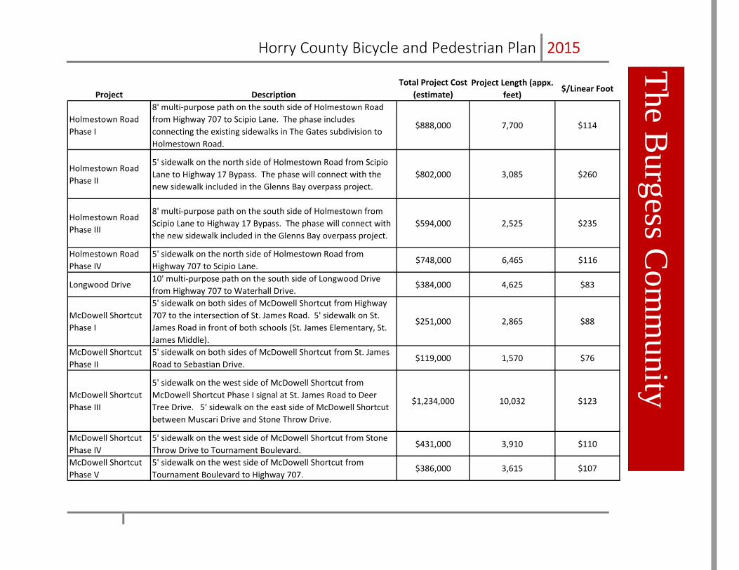
Holmestown Road Phase I
8' multi‐purpose path on the south side of Holmestown Road from Highway 707 to Scipio Lane. The phase includes connecting the existing sidewalks in The Gates subdivision to Holmestown Road.
$888,000 7,700 $114
Holmestown Road Phase II
5' sidewalk on the north side of Holmestown Road from Scipio Lane to Highway 17 Bypass. The phase will connect with the new sidewalk included in the Glenns Bay overpass project.
$802,000 3,085 $260
Holmestown Road Phase III
8' multi‐purpose path on the south side of Holmestown from Scipio Lane to Highway 17 Bypass. The phase will connect with the new sidewalk included in the Glenns Bay overpass project.
$594,000 2,525 $235
Holmestown Road Phase IV
5' sidewalk on the north side of Holmestown Road from Highway 707 to Scipio Lane.
$748,000 6,465 $116
Longwood Drive10' multi‐purpose path on the south side of Longwood Drive from Highway 707 to Waterhall Drive.
$384,000 4,625 $83
McDowell Shortcut Phase I
5' sidewalk on both sides of McDowell Shortcut from Highway 707 to the intersection of St. James Road. 5' sidewalk on St. James Road in front of both schools (St. James Elementary, St. James Middle).
$251,000 2,865 $88
McDowell Shortcut Phase II
5' sidewalk on both sides of McDowell Shortcut from St. James Road to Sebastian Drive.
$119,000 1,570 $76
McDowell Shortcut Phase III
5' sidewalk on the west side of McDowell Shortcut from McDowell Shortcut Phase I signal at St. James Road to Deer Tree Drive. 5' sidewalk on the east side of McDowell Shortcut between Muscari Drive and Stone Throw Drive.
$1,234,000 10,032 $123
McDowell Shortcut Phase IV
5' sidewalk on the west side of McDowell Shortcut from Stone Throw Drive to Tournament Boulevard.
$431,000 3,910 $110
McDowell Shortcut Phase V
5' sidewalk on the west side of McDowell Shortcut from Tournament Boulevard to Highway 707.
$386,000 3,615 $107
The Burgess C
omm
unity
danfordj
Text Box
B-10

Horry County Bicycle and Pedestrian Plan 2015
Project DescriptionTotal Project Cost
(estimate)Project Length (appx.
feet)$/Linear Foot
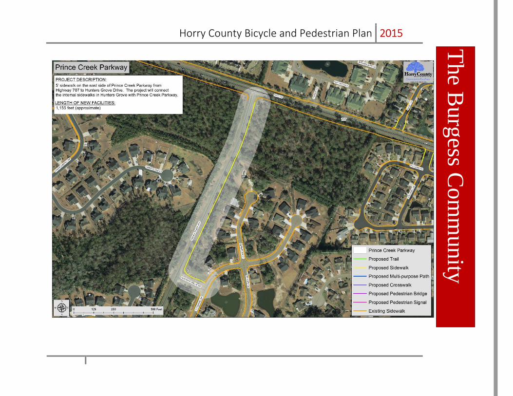
Prince Creek Parkway
5' sidewalk on the east side of Prince Creek Parkway from Highway 707 to Hunters Grove Drive. The project will connect the internal sidewalks in Hunters Grove with Prince Creek Parkway.
$107,000 1,155 $93
Prince Creek Trail Phase I
8' multi‐purpose path and elevated boardwalk throughout wooded areas on the western edge of Prince Creek. The project includes a parking area and trailhead at the current terminus of West Creek Drive, and a trailhead at the terminus of Wilderness Lane multi‐purpose path with a connection to Prince Creek Trail Phase II. Completion of the existing sidewalk on West Creek Drive that converts to a 8' multi‐purpose path extending to the current terminus of West Creek Drive.
$1,333,000 7,920 $168
Prince Creek Trail Phase II
8' multi‐purpose path and elevated boardwalk throughout wooded areas on the western edge of Prince Creek. Trailheads at Blackmoor Golf Course 10th fairway and the amenity center at Prince Creek Park. Public parking will not be available at either trailhead.
$1,779,000 7,026 $253
Salem Road
5' sidewalk on the north side of Salem Road from Freewoods Road to Highway 707. The project includes a 5' sidewalk on the south side of Salem Road from the St. James High School entrance to Highway 707.
$597,000 5,280 $113
Scipio Lane Phase I
10' multi‐purpose path on the east side of Scipio Lane from Holmestown Road to the South Strand Recreation Center. The project will connect to the existing trail system at South Strand Recreation Center.
$188,000 3,380 $56
Scipio Lane Phase II (Big Block)
10' multi‐purpose path that will coincide with the extension of Scipio Lane, which could potentially connect to Big Block Road or South Strand Commons and Highway 544.
$668,000 8,550 $78
The Burgess C
omm
unity
danfordj
Text Box
B-11
Horry County Bicycle and Pedestrian Plan 2015
Project DescriptionTotal Project Cost
(estimate)Project Length (appx.
feet)$/Linear Foot
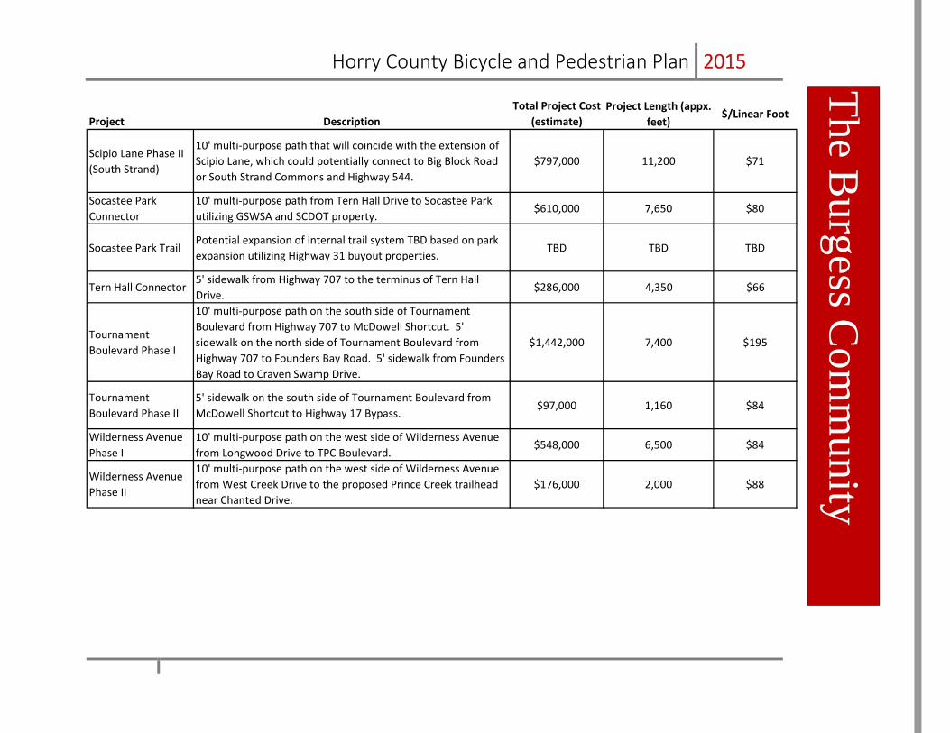
Scipio Lane Phase II (South Strand)
10' multi‐purpose path that will coincide with the extension of Scipio Lane, which could potentially connect to Big Block Road or South Strand Commons and Highway 544.
$797,000 11,200 $71
Socastee Park Connector
10' multi‐purpose path from Tern Hall Drive to Socastee Park utilizing GSWSA and SCDOT property.
$610,000 7,650 $80
Socastee Park TrailPotential expansion of internal trail system TBD based on park expansion utilizing Highway 31 buyout properties.
TBD TBD TBD
Tern Hall Connector5' sidewalk from Highway 707 to the terminus of Tern Hall Drive.
$286,000 4,350 $66
Tournament Boulevard Phase I
10' multi‐purpose path on the south side of Tournament Boulevard from Highway 707 to McDowell Shortcut. 5' sidewalk on the north side of Tournament Boulevard from Highway 707 to Founders Bay Road. 5' sidewalk from Founders Bay Road to Craven Swamp Drive.
$1,442,000 7,400 $195
Tournament Boulevard Phase II
5' sidewalk on the south side of Tournament Boulevard from McDowell Shortcut to Highway 17 Bypass.
$97,000 1,160 $84
Wilderness Avenue Phase I
10' multi‐purpose path on the west side of Wilderness Avenue from Longwood Drive to TPC Boulevard.
$548,000 6,500 $84
Wilderness Avenue Phase II
10' multi‐purpose path on the west side of Wilderness Avenue from West Creek Drive to the proposed Prince Creek trailhead near Chanted Drive.
$176,000 2,000 $88
The Burgess C
omm
unity
danfordj
Text Box
B-12

Horry County Bicycle and Pedestrian Plan 2015
The Burgess C
omm
unity
danfordj
Text Box
B-13

Horry County Bicycle and Pedestrian Plan 2015
The Burgess C
omm
unity
danfordj
Text Box
B-14

Horry County Bicycle and Pedestrian Plan 2015
The Burgess C
omm
unity
danfordj
Text Box
B-15

Horry County Bicycle and Pedestrian Plan 2015
The Burgess C
omm
unity
danfordj
Text Box
B-16

Horry County Bicycle and Pedestrian Plan 2015
The Burgess C
omm
unity
danfordj
Text Box
B-17

Horry County Bicycle and Pedestrian Plan 2015
The Burgess C
omm
unity
danfordj
Text Box
B-18

Horry County Bicycle and Pedestrian Plan 2015
The Burgess C
omm
unity
danfordj
Text Box
B-19

Horry County Bicycle and Pedestrian Plan 2015
The Burgess C
omm
unity The B
urgess Com
munity
danfordj
Text Box
B-20

Horry County Bicycle and Pedestrian Plan 2015
The Burgess C
omm
unity The B
urgess Com
munity
danfordj
Text Box
B-21

Horry County Bicycle and Pedestrian Plan 2015
The Burgess C
omm
unity The B
urgess Com
munity
danfordj
Text Box
B-22

Horry County Bicycle and Pedestrian Plan 2015
The Burgess C
omm
unity
danfordj
Text Box
B-23

Horry County Bicycle and Pedestrian Plan 2015
The Burgess C
omm
unity The B
urgess Com
munity
danfordj
Text Box
B-24

Horry County Bicycle and Pedestrian Plan 2015
The Burgess C
omm
unity The B
urgess Com
munity
danfordj
Text Box
B-25

Horry County Bicycle and Pedestrian Plan 2015
The Burgess C
omm
unity
danfordj
Text Box
B-26

Horry County Bicycle and Pedestrian Plan 2015
The Burgess C
omm
unity
danfordj
Text Box
B-27

Horry County Bicycle and Pedestrian Plan 2015
The Burgess C
omm
unity
danfordj
Text Box
B-28

Horry County Bicycle and Pedestrian Plan 2015
The Burgess C
omm
unity
danfordj
Text Box
B-29

Horry County Bicycle and Pedestrian Plan 2015
The Burgess C
omm
unity
danfordj
Text Box
B-30

Horry County Bicycle and Pedestrian Plan 2015
The Burgess C
omm
unity
danfordj
Text Box
B-31

Horry County Bicycle and Pedestrian Plan 2015
The Burgess C
omm
unity
danfordj
Text Box
B-32
Horry County Bicycle and Pedestrian Plan 2015
The Burgess C
omm
unity
danfordj
Text Box
B-33

Horry County Bicycle and Pedestrian Plan 2015
The Burgess C
omm
unity
danfordj
Text Box
B-34

Horry County Bicycle and Pedestrian Plan 2015
The Burgess C
omm
unity
danfordj
Text Box
B-35

Horry County Bicycle and Pedestrian Plan 2015
The Burgess C
omm
unity
danfordj
Text Box
B-36

Horry County Bicycle and Pedestrian Plan 2015
The Burgess C
omm
unity
danfordj
Text Box
B-37

Horry County Bicycle and Pedestrian Plan 2015
The Burgess C
omm
unity
danfordj
Text Box
B-38

Horry County Bicycle and Pedestrian Plan 2015
The Burgess C
omm
unity
danfordj
Text Box
B-39

Horry County Bicycle and Pedestrian Plan 2015
The Burgess C
omm
unity
danfordj
Text Box
B-40

Horry County Bicycle and Pedestrian Plan 2015
The Burgess C
omm
unity
danfordj
Text Box
B-41

Horry County Bicycle and Pedestrian Plan 2015
The Burgess C
omm
unity
danfordj
Text Box
B-42

Horry County Bicycle and Pedestrian Plan 2015
The Burgess C
omm
unity
danfordj
Text Box
B-43

Horry County Bicycle and Pedestrian Plan 2015
The Burgess C
omm
unity
danfordj
Text Box
B-44