
The Bida Basin in north-central Nigeria: sedimentology and ... · 3Department of Geology, Ahmadu...
13
Journal of Petroleum and Gas Exploration Research Vol. 1(1) pp. 001-013, September, 2011 Available online http://www.interesjournals.org/JPGER Copyright © 2011 International Research Journals Review The Bida Basin in north-central Nigeria: sedimentology and petroleum geology N. G. Obaje* 1 , M. K. Musa 1 , A. N. Odoma 2 , and H. Hamza 3 1 Department of Geology and Geography, Ibrahim Badamasi Babangida University, Lapai, Niger State, Nigeria. 2 Department of Earth Sciences, Kogi State University, Anyigba, Kogi State, Nigeria. 3 Department of Geology, Ahmadu Bello University, Zaria, Kaduna State, Nigeria. Accepted 28 July 2011. The sedimentary succession in the Bida Basin, central Nigeria, has the potential to include an active petroleum system with the generation, migration and accumulation of hydrocarbons in commercial quantities. Hydrocarbon seepages have been reported in the basin around Pategi/Muregi on the River Niger in Niger State and around Ahoko near Lokoja in Kogi State. Field sedimentological evaluation in four localities, namely, Lokoja, Agbaja, Ahoko, and Abaji, indicates braided - fluvial depositional facies for the Lokoja Formation; fluvial - flood plain–marine (shelf) facies for the Patti Formation and marginal marine–fluvial channels for the Agbaja Formation. Geochemical investigations show that potential source rocks in the Bida Basin are gas-prone. Potential reservoir units occur in the fluvial sandstones of the Lokoja Formation and in the shelf and flood plain sandstones of the Patti Formation. The shales and claystones of the Patti and Agbaja Formations may provide regional seals. Different trap configurations are possible in the basin, ranging from traps within uplifted blocks, traps in drapes and/or compacted structures over deep horsts to stratigraphic traps along flanks of uplifted blocks. Cross-sections indicate that the area around Bida, and to the south of Bida around Pategi, Muregi, Baro, Agbaja, Ahoko, Abaji, Gada Biyu, are particularly prospective. Keyword: Hydrocarbon, Bida basin, sedimentology, inland basins, Nigeria INTRODUCTION The Bida Basin, also known as the Mid-Niger or Nupe Basin, is located in west-central Nigeria (Figure. 1) Nigeria’s current proven petroleum reserves are about 38 billion barrels of oil and about 190 trillion standard cubic feet of gas and derive solely from the Niger Delta on- and offshore (Obaje, 2009). Exploration campaigns in the inland basins have been undertaken with the aim of expanding the national exploration and production base and adding to the proven reserves. Inland basins in Nigeria comprise the Anambra and Dahomey Basins in the south, the Lower, Middle and Upper Benue Trough, the Chad (Bornu) Basin in the NE, the Bida Basin, and the Sokoto Basin in the NW. Exploration of the inland basins have not been commercially successful to-date, principally because of the lack of knowledge of their geology and also because of their distance from the *Corresponding author Email: [email protected]. existing infrastructure. For these reasons, many international companies have turned their focus away from the onshore to frontier deep-water and ultra deep- water offshore. The inland basins of Nigeria constitute one set of a series of Cretaceous and later rift basins in Central and West Africa whose origin is related to the opening of the South Atlantic (Figure. 2) Commercial hydrocarbon accumulations have recently been discovered in Chad, Niger and Sudan within this rift trend. In SW Chad, development of the Doba discovery (with estimated reserves of about 1 billion barrels) has resulted in the construction of a 1070 km long pipeline to the Atlantic coast (Mohamed et al., 1999). In the Sudan, “giant” fields (including Unity 1 and 2, Kaikang and Heglig) have been discovered in the Muglad Basin (Mohamed et al., 1999). These discoveries have encouraged geological, geochemical and geophysical studies in the Nigerian inland basins. This paper attempts to evaluate the sedimentological characteristics of the deposits in the
Transcript of The Bida Basin in north-central Nigeria: sedimentology and ... · 3Department of Geology, Ahmadu...
Journal of Petroleum and Gas Exploration Research Vol. 1(1) pp. 001-013, September, 2011 Available online http://www.interesjournals.org/JPGER Copyright © 2011 International Research Journals
Review
The Bida Basin in north-central Nigeria: sedimentology and petroleum geology
N. G. Obaje*1, M. K. Musa1, A. N. Odoma2, and H. Hamza3
1Department of Geology and Geography, Ibrahim Badamasi Babangida University, Lapai, Niger State, Nigeria.
2Department of Earth Sciences, Kogi State University, Anyigba, Kogi State, Nigeria. 3Department of Geology, Ahmadu Bello University, Zaria, Kaduna State, Nigeria.
Accepted 28 July 2011.
The sedimentary succession in the Bida Basin, central Nigeria, has the potential to include an active petroleum system with the generation, migration and accumulation of hydrocarbons in commercial quantities. Hydrocarbon seepages have been reported in the basin around Pategi/Muregi on the River Niger in Niger State and around Ahoko near Lokoja in Kogi State. Field sedimentological evaluation in four localities, namely, Lokoja, Agbaja, Ahoko, and Abaji, indicates braided - fluvial depositional facies for the Lokoja Formation; fluvial - flood plain–marine (shelf) facies for the Patti Formation and marginal marine–fluvial channels for the Agbaja Formation. Geochemical investigations show that potential source rocks in the Bida Basin are gas-prone. Potential reservoir units occur in the fluvial sandstones of the Lokoja Formation and in the shelf and flood plain sandstones of the Patti Formation. The shales and claystones of the Patti and Agbaja Formations may provide regional seals. Different trap configurations are possible in the basin, ranging from traps within uplifted blocks, traps in drapes and/or compacted structures over deep horsts to stratigraphic traps along flanks of uplifted blocks. Cross-sections indicate that the area around Bida, and to the south of Bida around Pategi, Muregi, Baro, Agbaja, Ahoko, Abaji, Gada Biyu, are particularly prospective. Keyword: Hydrocarbon, Bida basin, sedimentology, inland basins, Nigeria
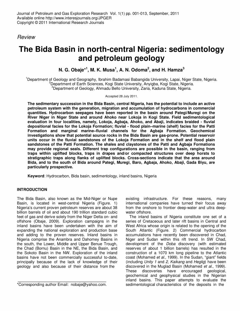
INTRODUCTION The Bida Basin, also known as the Mid-Niger or Nupe Basin, is located in west-central Nigeria (Figure. 1) Nigeria’s current proven petroleum reserves are about 38 billion barrels of oil and about 190 trillion standard cubic feet of gas and derive solely from the Niger Delta on- and offshore (Obaje, 2009). Exploration campaigns in the inland basins have been undertaken with the aim of expanding the national exploration and production base and adding to the proven reserves. Inland basins in Nigeria comprise the Anambra and Dahomey Basins in the south, the Lower, Middle and Upper Benue Trough, the Chad (Bornu) Basin in the NE, the Bida Basin, and the Sokoto Basin in the NW. Exploration of the inland basins have not been commercially successful to-date, principally because of the lack of knowledge of their geology and also because of their distance from the *Corresponding author Email: [email protected].
existing infrastructure. For these reasons, many international companies have turned their focus away from the onshore to frontier deep-water and ultra deep-water offshore.
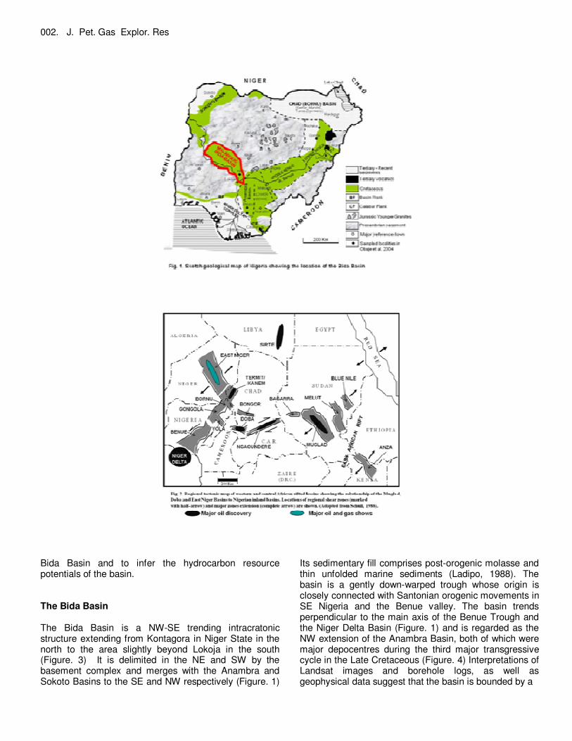
The inland basins of Nigeria constitute one set of a series of Cretaceous and later rift basins in Central and West Africa whose origin is related to the opening of the South Atlantic (Figure. 2) Commercial hydrocarbon accumulations have recently been discovered in Chad, Niger and Sudan within this rift trend. In SW Chad, development of the Doba discovery (with estimated reserves of about 1 billion barrels) has resulted in the construction of a 1070 km long pipeline to the Atlantic coast (Mohamed et al., 1999). In the Sudan, “giant” fields (including Unity 1 and 2, Kaikang and Heglig) have been discovered in the Muglad Basin (Mohamed et al., 1999). These discoveries have encouraged geological, geochemical and geophysical studies in the Nigerian inland basins. This paper attempts to evaluate the sedimentological characteristics of the deposits in the
002. J. Pet. Gas Explor. Res
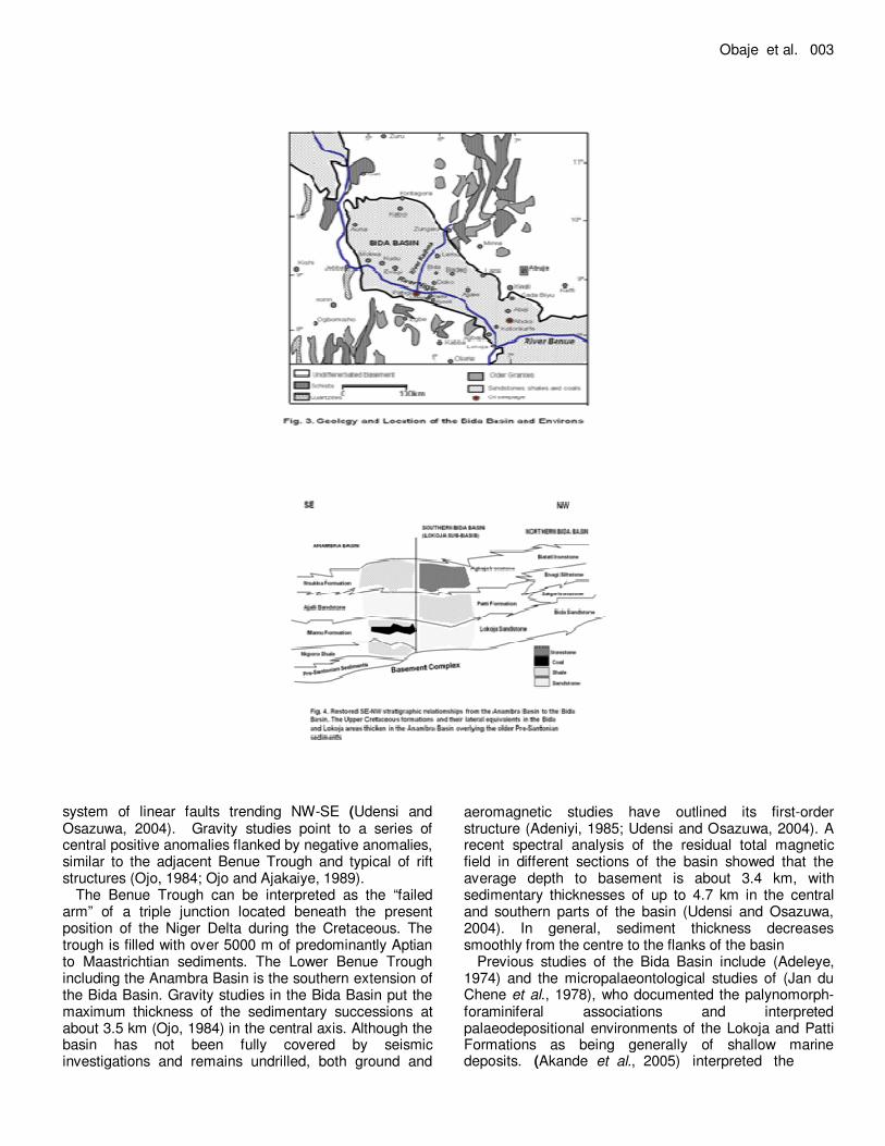
Bida Basin and to infer the hydrocarbon resource potentials of the basin. The Bida Basin The Bida Basin is a NW-SE trending intracratonic structure extending from Kontagora in Niger State in the north to the area slightly beyond Lokoja in the south (Figure. 3) It is delimited in the NE and SW by the basement complex and merges with the Anambra and Sokoto Basins to the SE and NW respectively (Figure. 1)
Its sedimentary fill comprises post-orogenic molasse and thin unfolded marine sediments (Ladipo, 1988). The basin is a gently down-warped trough whose origin is closely connected with Santonian orogenic movements in SE Nigeria and the Benue valley. The basin trends perpendicular to the main axis of the Benue Trough and the Niger Delta Basin (Figure. 1) and is regarded as the NW extension of the Anambra Basin, both of which were major depocentres during the third major transgressive cycle in the Late Cretaceous (Figure. 4) Interpretations of Landsat images and borehole logs, as well as geophysical data suggest that the basin is bounded by a
Obaje et al. 003
system of linear faults trending NW-SE (Udensi and Osazuwa, 2004). Gravity studies point to a series of central positive anomalies flanked by negative anomalies, similar to the adjacent Benue Trough and typical of rift structures (Ojo, 1984; Ojo and Ajakaiye, 1989).
The Benue Trough can be interpreted as the “failed arm” of a triple junction located beneath the present position of the Niger Delta during the Cretaceous. The trough is filled with over 5000 m of predominantly Aptian to Maastrichtian sediments. The Lower Benue Trough including the Anambra Basin is the southern extension of the Bida Basin. Gravity studies in the Bida Basin put the maximum thickness of the sedimentary successions at about 3.5 km (Ojo, 1984) in the central axis. Although the basin has not been fully covered by seismic investigations and remains undrilled, both ground and
aeromagnetic studies have outlined its first-order structure (Adeniyi, 1985; Udensi and Osazuwa, 2004). A recent spectral analysis of the residual total magnetic field in different sections of the basin showed that the average depth to basement is about 3.4 km, with sedimentary thicknesses of up to 4.7 km in the central and southern parts of the basin (Udensi and Osazuwa, 2004). In general, sediment thickness decreases smoothly from the centre to the flanks of the basin
Previous studies of the Bida Basin include (Adeleye, 1974) and the micropalaeontological studies of (Jan du Chene et al., 1978), who documented the palynomorph-foraminiferal associations and interpreted palaeodepositional environments of the Lokoja and Patti Formations as being generally of shallow marine deposits. (Akande et al., 2005) interpreted the
004. J. Pet. Gas Explor. Res
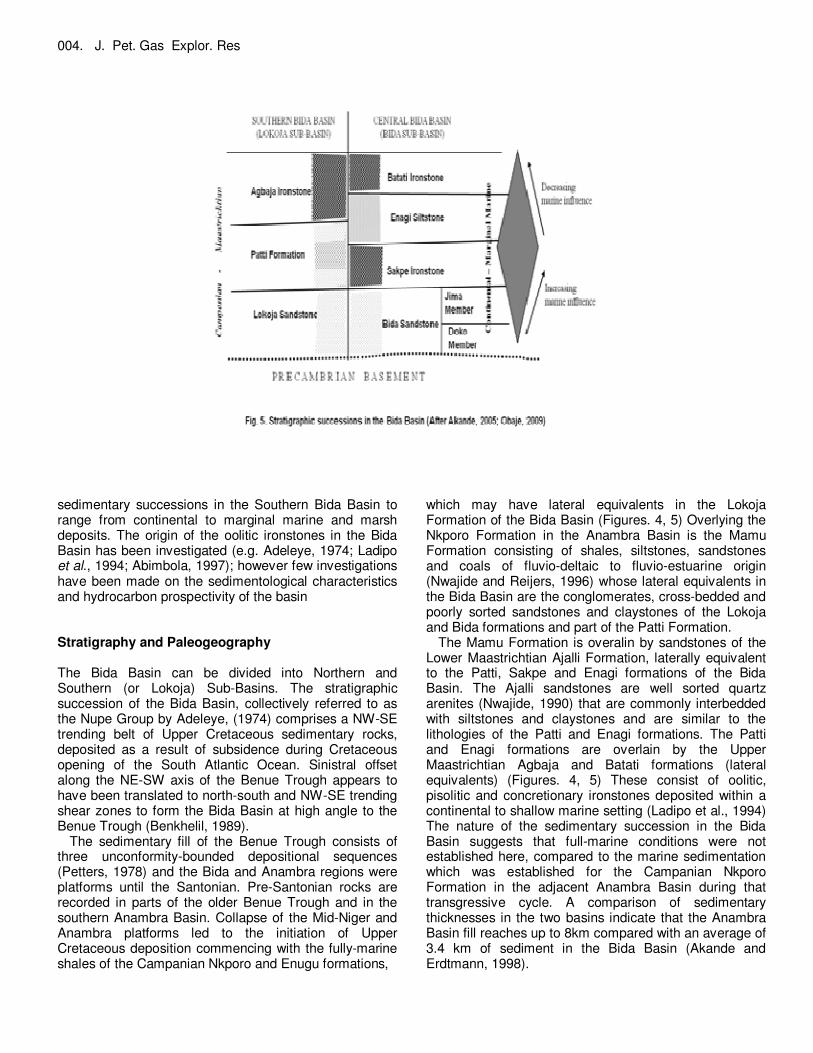
sedimentary successions in the Southern Bida Basin to range from continental to marginal marine and marsh deposits. The origin of the oolitic ironstones in the Bida Basin has been investigated (e.g. Adeleye, 1974; Ladipo et al., 1994; Abimbola, 1997); however few investigations have been made on the sedimentological characteristics and hydrocarbon prospectivity of the basin Stratigraphy and Paleogeography The Bida Basin can be divided into Northern and Southern (or Lokoja) Sub-Basins. The stratigraphic succession of the Bida Basin, collectively referred to as the Nupe Group by Adeleye, (1974) comprises a NW-SE trending belt of Upper Cretaceous sedimentary rocks, deposited as a result of subsidence during Cretaceous opening of the South Atlantic Ocean. Sinistral offset along the NE-SW axis of the Benue Trough appears to have been translated to north-south and NW-SE trending shear zones to form the Bida Basin at high angle to the Benue Trough (Benkhelil, 1989).
The sedimentary fill of the Benue Trough consists of three unconformity-bounded depositional sequences (Petters, 1978) and the Bida and Anambra regions were platforms until the Santonian. Pre-Santonian rocks are recorded in parts of the older Benue Trough and in the southern Anambra Basin. Collapse of the Mid-Niger and Anambra platforms led to the initiation of Upper Cretaceous deposition commencing with the fully-marine shales of the Campanian Nkporo and Enugu formations,
which may have lateral equivalents in the Lokoja Formation of the Bida Basin (Figures. 4, 5) Overlying the Nkporo Formation in the Anambra Basin is the Mamu Formation consisting of shales, siltstones, sandstones and coals of fluvio-deltaic to fluvio-estuarine origin (Nwajide and Reijers, 1996) whose lateral equivalents in the Bida Basin are the conglomerates, cross-bedded and poorly sorted sandstones and claystones of the Lokoja and Bida formations and part of the Patti Formation.
The Mamu Formation is overalin by sandstones of the Lower Maastrichtian Ajalli Formation, laterally equivalent to the Patti, Sakpe and Enagi formations of the Bida Basin. The Ajalli sandstones are well sorted quartz arenites (Nwajide, 1990) that are commonly interbedded with siltstones and claystones and are similar to the lithologies of the Patti and Enagi formations. The Patti and Enagi formations are overlain by the Upper Maastrichtian Agbaja and Batati formations (lateral equivalents) (Figures. 4, 5) These consist of oolitic, pisolitic and concretionary ironstones deposited within a continental to shallow marine setting (Ladipo et al., 1994) The nature of the sedimentary succession in the Bida Basin suggests that full-marine conditions were not established here, compared to the marine sedimentation which was established for the Campanian Nkporo Formation in the adjacent Anambra Basin during that transgressive cycle. A comparison of sedimentary thicknesses in the two basins indicate that the Anambra Basin fill reaches up to 8km compared with an average of 3.4 km of sediment in the Bida Basin (Akande and Erdtmann, 1998).
Obaje et al. 005
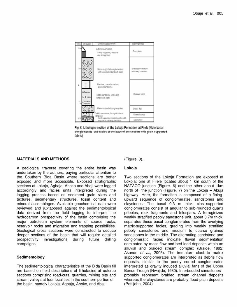
MATERIALS AND METHODS A geological traverse covering the entire basin was undertaken by the authors, paying particular attention to the Southern Bida Basin where sections are better exposed and more accessible. Exposed stratigraphic sections at Lokoja, Agbaja, Ahoko and Abaji were logged accordingly and facies units interpreted during the logging process based on sediment grain sizes and textures, sedimentary structures, fossil content and mineral assemblages. Available geochemical data were reviewed and juxtaposed against the sedimentological data derived from the field logging to interpret the hydrocarbon prospectivity of the basin comprising the major petroleum system elements of source rocks, reservoir rocks and migration and trapping possibilities. Geological cross sections were constructed to deduce deeper sections of the basin that will require detailed prospectivity investigations during future drilling campaigns. Sedimentology The sedimentological characteristics of the Bida Basin fill are based on field descriptions of lithofacies at outcrop sections comprising road-cuts, quarries, mining pits and stream valleys at four localities in the southern portion of the basin, namely Lokoja, Agbaja, Ahoko, and Abaji
(Figure. 3). Lokoja Two sections of the Lokoja Formation are exposed at Lokoja; one at Filele located about 1 km south of the NATACO junction (Figure. 6) and the other about 1km north of the junction (Figure. 7) on the Lokoja – Abuja highway. Here, the formaiton is composed of a fining-upward sequence of conglomerates, sandstones and claystones. The basal 0.3 m thick, clast-supported conglomerates consist of angular to sub-rounded quartz pebbles, rock fragments and feldspars. A ferruginized weakly stratified pebbly sandstone unit, about 0.7m thick, separates these basal conglomerates from the overlying matrix-supported facies, grading into weakly stratified pebbly sandstones and medium to coarse grained sandstones in the middle. The alternating sandstone and conglomeratic facies indicate fluvial sedimentation dominated by mass flow and bed-load deposits within an alluvial and braided stream complex (Braide, 1992; Akande et al., 2006). The immature clast to matrix supported conglomerates are interpreted as debris flow deposits, similar to the poorly sorted conglomerates interpreted as gravity induced alluvial fans of the Upper Benue Trough (Nwajide, 1980). Interbedded sandstones probably represent braided stream channel deposits whereas the claystones are probably flood plain deposits (Pettijohn, 2004)

006. J. Pet. Gas Explor. Res
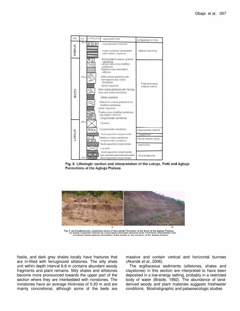
Agbaja From the base to the top of the Agbaja Plateau, a section about 74m thick is exposed comprising the conglomeratic and sandstone facies of the Lokoja Formation, overlying siltstones, fine-grained sandstones and claystones of the Patti Formation and the ironstones of Agbaja Formation (Figures. 8, 9) At the base is a matrix-supported, ferruginized conglomerate. This conglomerate consists of boulders, cobbles and pebble-sized clasts of varying degree of roundness, ranging from angular to well rounded with strong evidence of reworking. This grades upward into massive bedded, coarse- to medium-grained sandstones. This cycle is repeated towards the middle of this section. Some of the conglomeratic units show graded bedding and reach thicknesses of up to about 40m, and represent the Patti Formation at this location. The well-sorted sandstone units are friable, displaying herringbone cross-stratifications, hummocks, small- and large-scale planar cross-beddings and are bioturbated. The units are interbedded with massive claystones, and wavy to parallel laminated siltstones along depositional strike, interbedded with fine- to coarse-grained sandstones. Interbedded claystones are silty, kaolinitic, massive and in places sandy. Oolithic ironstones of the Agbaja Formation overlie this succession, and pass sharply into concretional ironstones. The concretions range in diameter from 5 cm to 50 cm.
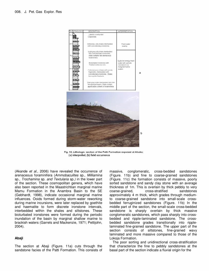
The alternating conglomerates and sandstones of the Lokoja Formation in the lower part of the section reflect continental deposition influenced largely by alluvial and braided stream processes (Akande et al., 2006). The massive matrix-supported conglomerate corresponds to a debris flow in an alluvial fan setting. The conglomeratic unit with graded bedding is interpreted as an abandoned channel deposit. Herringbone cross-stratification, bioturbation and wave ripples associated with the sandstones of the Patti Formation indicate shallow-marine conditions and tidal channels (Pettijohn, 2004) The textural and mineralogical maturity of the sandstones suggest long-distance transportation and marine reworking (Garrels and Mackenzie, 1971) Ahoko In the outcrop section at Ahoko, 49 km from Lokoja on the Lokoja – Abuja expressway (Figure. 10) the argillaceous units of the Patti Formation are well exposed. The approximately 26 m thick section here consists predominantly of shales and siltstones which are rhythmically interbedded with concretional to massive, bioturbated ironstones. At the basal part of the section is a prominent shale bed with an average thickness of 0.5 m. Shales are dark to light grey, carbonaceous and
Obaje et al. 007
fissile, and dark grey shales locally have fractures that are in-filled with ferruginized siltstones. The silty shale unit within depth interval 6-8 m contains abundant woody fragments and plant remains. Silty shales and siltstones become more pronounced towards the upper part of the section where they are interbedded with ironstones. The ironstones have an average thickness of 0.20 m and are mainly concretional, although some of the beds are
massive and contain vertical and horizontal burrows (Akande et al., 2006).
The argillaceous sediments (siltstones, shales and claystones) in this section are interpreted to have been deposited in a low-energy setting, probably in a restricted body of water (Braide, 1992). The abundance of land-derived woody and plant materials suggests freshwater conditions. Biostratigraphic and palaeoecologic studies
008. J. Pet. Gas Explor. Res
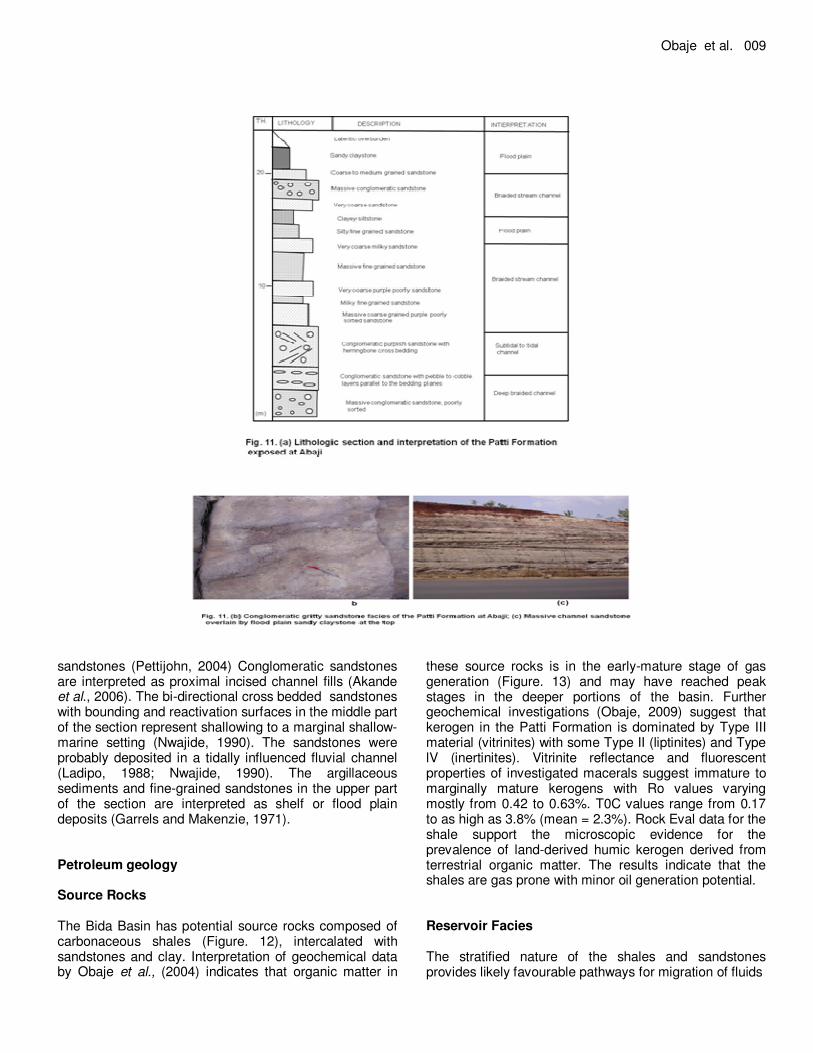
(Akande et al., 2006) have revealed the occurrence of arenaceous foraminifera (Ammobaculites sp., Milliamina sp., Trochamina sp. and Textularia sp.) in the lower part of the section. These cosmopolitan genera, which have also been reported in the Maastrichtian marginal marine Mamu Formation in the Anambra Basin to the SE (Gebhardt, 1998), indicate occasional marginal marine influences. Ooids formed during storm-water reworking during marine incursions, were later replaced by goethite and haematite to form discrete ironstone intervals, interbedded within the shales and siltstones. These bioturbated ironstones were formed during the periodic inundation of the basin by marginal shallow marine to brackish waters (Garrels and Mackenzie, 1971; Pettijohn, 2004). Abaji The section at Abaji (Figure. 11a) cuts through the sandstone facies of the Patti Formation. This consists of
massive, conglomeratic, cross-bedded sandstones (Figure. 11b) and fine to coarse-grained sandstones (Figure. 11c) the formation consists of massive, poorly sorted sandstone and sandy clay stone with an average thickness of 1m. This is overlain by thick pebbly to very coarse-grained, cross-stratified sandstones approximately 4 m thick, which grades through medium- to coarse-grained sandstone into small-scale cross-bedded ferruginized sandstones (Figure. 11b) In the middle part of the section, the small-scale cross-bedded sandstone is sharply overlain by thick massive conglomeratic sandstones, which pass sharply into cross-bedded and ripple-laminated sandstone. The cross-bedded sandstone grades transitionally into ripple-laminated fine-grained sandstone. The upper part of the section consists of siltstones, fine-grained wavy laminated and more massive compared to those of the Lokoja Formation.
The poor sorting and unidirectional cross-stratification that characterize the fine to pebbly sandstones at the basal part of the section indicate a fluvial origin for the
Obaje et al. 009
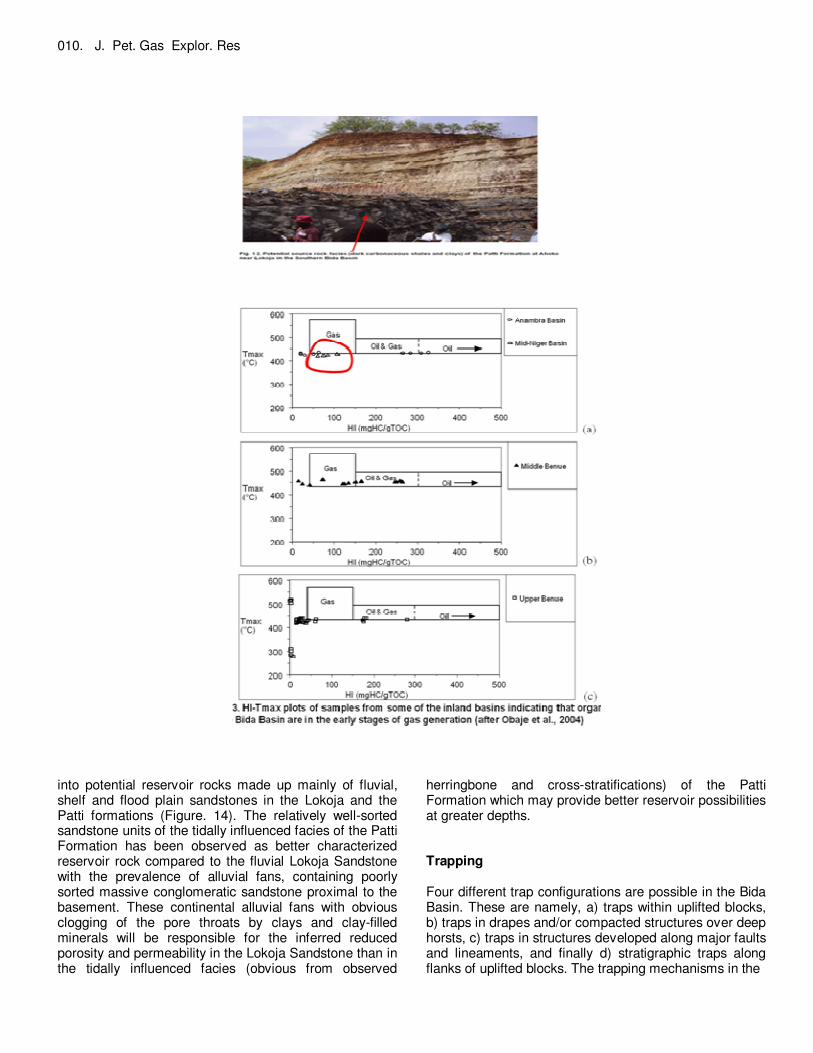
sandstones (Pettijohn, 2004) Conglomeratic sandstones are interpreted as proximal incised channel fills (Akande et al., 2006). The bi-directional cross bedded sandstones with bounding and reactivation surfaces in the middle part of the section represent shallowing to a marginal shallow-marine setting (Nwajide, 1990). The sandstones were probably deposited in a tidally influenced fluvial channel (Ladipo, 1988; Nwajide, 1990). The argillaceous sediments and fine-grained sandstones in the upper part of the section are interpreted as shelf or flood plain deposits (Garrels and Makenzie, 1971). Petroleum geology Source Rocks The Bida Basin has potential source rocks composed of carbonaceous shales (Figure. 12), intercalated with sandstones and clay. Interpretation of geochemical data by Obaje et al., (2004) indicates that organic matter in
these source rocks is in the early-mature stage of gas generation (Figure. 13) and may have reached peak stages in the deeper portions of the basin. Further geochemical investigations (Obaje, 2009) suggest that kerogen in the Patti Formation is dominated by Type III material (vitrinites) with some Type II (liptinites) and Type lV (inertinites). Vitrinite reflectance and fluorescent properties of investigated macerals suggest immature to marginally mature kerogens with Ro values varying mostly from 0.42 to 0.63%. T0C values range from 0.17 to as high as 3.8% (mean = 2.3%). Rock Eval data for the shale support the microscopic evidence for the prevalence of land-derived humic kerogen derived from terrestrial organic matter. The results indicate that the shales are gas prone with minor oil generation potential. Reservoir Facies The stratified nature of the shales and sandstones provides likely favourable pathways for migration of fluids
010. J. Pet. Gas Explor. Res
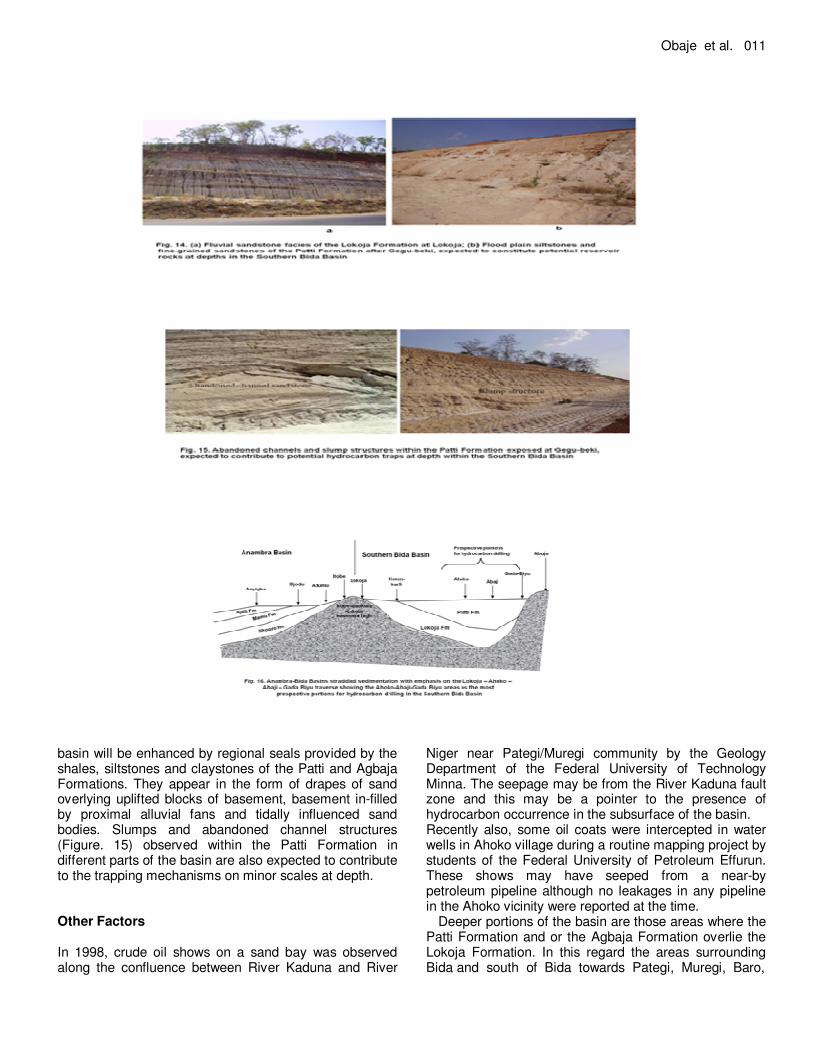
into potential reservoir rocks made up mainly of fluvial, shelf and flood plain sandstones in the Lokoja and the Patti formations (Figure. 14). The relatively well-sorted sandstone units of the tidally influenced facies of the Patti Formation has been observed as better characterized reservoir rock compared to the fluvial Lokoja Sandstone with the prevalence of alluvial fans, containing poorly sorted massive conglomeratic sandstone proximal to the basement. These continental alluvial fans with obvious clogging of the pore throats by clays and clay-filled minerals will be responsible for the inferred reduced porosity and permeability in the Lokoja Sandstone than in the tidally influenced facies (obvious from observed
herringbone and cross-stratifications) of the Patti Formation which may provide better reservoir possibilities at greater depths. Trapping Four different trap configurations are possible in the Bida Basin. These are namely, a) traps within uplifted blocks, b) traps in drapes and/or compacted structures over deep horsts, c) traps in structures developed along major faults and lineaments, and finally d) stratigraphic traps along flanks of uplifted blocks. The trapping mechanisms in the
Obaje et al. 011
basin will be enhanced by regional seals provided by the shales, siltstones and claystones of the Patti and Agbaja Formations. They appear in the form of drapes of sand overlying uplifted blocks of basement, basement in-filled by proximal alluvial fans and tidally influenced sand bodies. Slumps and abandoned channel structures (Figure. 15) observed within the Patti Formation in different parts of the basin are also expected to contribute to the trapping mechanisms on minor scales at depth. Other Factors In 1998, crude oil shows on a sand bay was observed along the confluence between River Kaduna and River
Niger near Pategi/Muregi community by the Geology Department of the Federal University of Technology Minna. The seepage may be from the River Kaduna fault zone and this may be a pointer to the presence of hydrocarbon occurrence in the subsurface of the basin. Recently also, some oil coats were intercepted in water wells in Ahoko village during a routine mapping project by students of the Federal University of Petroleum Effurun. These shows may have seeped from a near-by petroleum pipeline although no leakages in any pipeline in the Ahoko vicinity were reported at the time.
Deeper portions of the basin are those areas where the Patti Formation and or the Agbaja Formation overlie the Lokoja Formation. In this regard the areas surrounding Bida and south of Bida towards Pategi, Muregi, Baro,
012. J. Pet. Gas Explor. Res Agbaja, Ahoko, Abaji, Gada Biyu are possibly the most prospective for exploration drilling. In a traverse from Lokoja to Gada Biyu on the Lokoja-Abuja expressway, the localities towards Ahoko through Abaji to Gada Biyu have been identified as most prospective for hydrocarbon exploratory drilling campaigns (Figure. 16). Shaly units of the Patti and Agbaja formations would provide regional seals for any trapped hydrocarbons in the southern portion of the basin. CONCLUSIONS A major constraint to onshore exploration in Nigeria is the lack of knowledge of the subsurface geology of the inland basins, as only a very few exploration wells have been drilled. Another limiting factor has been an overdependence on geophysics at the expense of other geological studies such as geochemistry and sedimentology. It is also necessary to apply appropriate analogues to the inland basins, whose stratigraphy and sedimentology is distinct from that of the better-studied Niger Delta Basin.
Field sedimentological evaluations show that the basal parts of the Lokoja Formation were deposited in braided stream environments characterized by debris flow, mass flow and bed-load deposits, while the middle and upper parts were deposited in fluvial channel environments. The basal portions of the Patti Formation are characterized by fluvial channel facies, the middle portions correspond to flood plain deposits while the upper portions are interpreted as shallow marine deposits. Marine influences in the upper Patti Formation persisted into the lower Agbaja Formation with the remaining upper portions indicating channel deposits of fluvial origin.
Geochemical investigations have shown that potential source rocks in the Bida Basin are gas-prone. Potential reservoir rocks in the Bida Basin include fluvial sandstones in the Lokoja Formation, and well-sorted shelf and flood plain sandstones in the Patti Formation. The shales and claystones of the Patti and Agbaja formations may provide regional seals in the Southern Bida Basin. Different trap configurations are possible in the basin. The presence of unconformities, slump structures and abandoned channels are further indications of potential hydrocarbon traps in the deeper subsurface sections of the basin. ACKNOWLEDGEMENTS The field guide on the Bida Basin provided by Professor S. O. Akande and his team at the University of Ilorin for the NAPE 2006 excursion assisted greatly in the interpretation of the sedimentological features of the Bida
Basin. A grant by the Raw Materials Research and Development Council (Abuja) to the first author for the study of Nigerian coal resources enabled him to make traverses through the Southern Bida Basin to access the Okaba and Ogboyaga coal deposits in the northern Anambra Basin. This grant is therefore gratefully acknowledged. REFERENCES Abimbola FA, (1997). Petrographic and paragenetic studies of the
Agbaja Ironstone Formation, Nupe Basin, Nigeria. J. Afr. Earth Sci. 25:169–181.
Adeleye DR, (1974). Sedimentology of the fluvial Bida Sandstones (Cretaceous) Nigeria. Sedimentary Geology 12:1-24.
Adeniyi JO, (1985). Ground total magnetic intensity in parts of the Nupe Basin and the adjacent basement complex, Niger State, Nigeria. Nigerian J. Appl. Sci. 3: 67–78.
Akande SO, Erdtmann, BD (1998). Burial metamorphism (thermal maturation) in Cretaceous sediments of the Southern Benue Trough and Anambra Basin, Nigeria. AAPG Bull, 82:1191–1206.
Akande SO, Ojo OJ, Erdtmann BD, Hetenyi M (2005). Paleoenvironments, organic petrology and Rock-Eval studies on source rock facies of the Lower Maastrichtian Patti Formation, southern Bida Basin, Nigeria. J. Afri. Earth Sci. 41:394-406.
Akande SO, Ojo OJ, Adekeye OA, Ladipo KO, (2006). A Geological Field Duide to the Southern Bida Basin. Nigerian Association of Petroleum Explorationists (NAPE), 24th Annual Conference and Exhibition, Abuja, pp 21.
Benkhelil J, (1989). The origin and evolution of the Cretaceous Benue Trough, Nigeria. J. Afr. Earth Sci. 8:251–282.
Braide SP (1992). Syntectonic fluvial sedimentation in the central Bida Basin. J. Mining and Geol. 28:55–64.
Garrels RM, Mackenzie FT (1971). Evolution of Sedimentary Rocks. Norton, New York, pp 397.
Gebhardt H (1998). Benthic foraminifera from the Maastrichtian Lower Mamu Formation near Leru (Southern Nigeria): paleoecology and paleogeographic significance. J. Foraminiferal Res. 28:76–89.
Jan Du Chene RE, Klasz IDE, Archibong EE (1979). Biostratigraphic study of the borehole Ojo-1, SW Nigeria, with special emphasis on the Cretaceous microflora. Revue de Micropalaeontologie, 21:123-139.
Ladipo KO (1988). Paleogeography, sedimentation and tectonics of the Upper Cretaceous Anambra Basin, south-eastern Nigeria. J. Afr. Earth Sci. 7:865–871.
Ladipo KO, Akande SO, Mucke A (1994). Genesis of ironstones from the Mid-Niger sedimentary basin: evidence from sedimentological, ore microscopic and geochemical studies. J. Mining and Geol. 30: 161-168.
Mohamed AY, Pearson MJ, Ashcroft WA, Illiffe JE, Whiteman AJ (1999). Modelling petroleum generation in the Southern Muglad rift basin, Sudan. AAPG Bull. 83:1943-1964.
Nwajide CS (1990). Sedimentation and paleogeography of the Central Benue Trough, Nigeria. In: Ofoegbu, C. O. (Ed.), The Benue Trough Structure and Evolution. Vieweg, Braunschweig, pp19-38.
Nwajide CS, Reijers TJA (1996). Sequence architecture in outcrops: examples from the Anambra Basin, Nigeria. Nigerian Association of
Petroleum Explorationists Bulletin, 11: 23–33. Obaje NG, Wehner H, Scheeder G, Abubakar MB. Jauro A (2004).
Hydrocarbon prospectivity of Nigeria’s inland basins: from the viewpoint of organic geochemistry and organic petrology. AAPG Bull., 87:325–353. Obaje NG (2009). Geology and Mineral Resources of Nigeria. Springer,
Heidelberg, pp 221. Ojo SB (1984). Middle Niger Basin revisited: magnetic constraints on
gravity interpretations. Abstract, 20th Conference of the Nigeria Mining and Geosciences Society, Nsukka, pp 52–53.
Ojo SB, Ajakaiye DE (1989). Preliminary interpretation of gravity measurements in the Mid-Niger Basin area, Nigeria. In: Kogbe, C.A.

(Ed.), Geology of Nigeria. 2nd edition, Elizabethan Publishers, Lagos,
pp 347–358. Petters SW (1978). Middle Cretaceous paleoenvironments and
biostratigraphy of the Benue Trough, Nigeria. Geol. Soc. Amer. Bull.,
89:151–154. Pettijohn JF (2004). Sedimentary Rocks, 3
rd Edition. CBS Publishers
and Distributors, New Delhi, pp 628.
Obaje et al. 013 Udensi EE, Osazuwa IB (2004). Spectral determination of depths to
magnetic rocks under the Nupe Basin, Nigeria. Nigerian Association of Petroleum Explorationists (NAPE) Bull., 17:22–27.