The Atlantic Coastal Pine Barrens is a disjunct ecoregion€¦ · Land Cover Trends Ecoregion...
4
Land Cover Trends Ecoregion Description The Atlantic Coastal PineBarrens is a disjunctecoregion coveringapproximately 6,200square miles of the coastal plain of New Jersey, Long Island in NewYork,and CapeCod, Martha'sVineyard, and Nantucket in Massachusetts, as well as nearby islands. Hydrology,soils,fire regimes, and vegetation combine to distinguish this ecoregion from neighboring ecoregions. The region hasa wide varietyof ecologicalsystems, including cedarswamps, meadows, stunted pitch pine andoak forests, sphagnum bogs, heathlands, coastal salt ponds, dune systems, andthe Nation's only maritimegrasslands onMartha's VineyardandLong Island. Rainfall averages about 48 inchesper year, but the soil is sandy, extremely porous, and drains veryquickly. Soils and waterin the ecoregion are generally very acidic, which limits naturally occurring flora, fauna, and suitable agricultural crops. Acid-tol- erantshrubs, such as those of the heath family (blueberries, laurels, staggerbush), arecommon. Agricultural activity in many areas is limited to acid-loving crops, such asblueberries and cranberries, although partsof the ecoregion with richersoils support fruits, vegetables, and other crops. Aquatic faunamust also be acid-tolerant, resulting in relatively few species of freshwater fish and amphibians. The Atlantic Coastal Pine Barrens. The areas in color represent land cover types for the Atlantic Coastal Pine Barrens ecoregion. The nine 20- hy 2O-km sample sites for the land Cover Trends project are shown in yellow. Historically, fire is the majordisturbance factorinfluencing vegetation composition in the ecoregion. In its natural state, the landscape is swept by frequent fires,giving the advantage to species ableto cope, such as pitch pine, scrub oak,heath shrubs, and bracken fern. Parts of the ecoregion represent some of the best preserved habi- tat in the Eastern United States, but others are among the most highly developed lands in the country. The western half of Long Island, as well as much of the Jersey Shore and Cape Cod, is very densely populated and developed. Historical land Use and land Cover Early land useandland cover change wasbased largely on natural resource extraction, especially on the useof vasttimber resources. Rot-resistant white cedar was in high demand for shingling, ship building,and otheruses. Pitchpine provided a source of strong, dense, high-qualitywood for flooring, furniture,construction, and fuel, andthe pine's resinwas widely usedfor naval stores. The enormous demand for wood,coupled with uncontrollable forestfires, drastically changed the landscape of the regionfrom its prehistoric form (Berger and Sinton, 1985, 117). Early in the 19th century, a booming iron industry began. The New JerseyPine Barrens were rich with "bog iron," natural deposits of iron-rich material. Clam and oyster shells from the shoreline were harvested to provide lime required for smelting, and the vast forestlands provided the fuel. However, the produc- tion of bog iron ended by the 1860s,because higher grade iron and coal deposits discovered in Pennsylvania and elsewhere were much more efficient to exploit. u.s. Depar1ment of the Interior U.S.Geological Survey USGS Fact Sheet FS-092-03 July 2003 (1) Printedon recycled paper
Transcript of The Atlantic Coastal Pine Barrens is a disjunct ecoregion€¦ · Land Cover Trends Ecoregion...
Land Cover Trends
Ecoregion DescriptionThe Atlantic Coastal Pine Barrens is a disjunct ecoregioncovering approximately 6,200 square miles of the coastal plainof New Jersey, Long Island in New York, and Cape Cod,Martha's Vineyard, and Nantucket in Massachusetts, as well asnearby islands. Hydrology, soils, fire regimes, and vegetationcombine to distinguish this ecoregion from neighboringecoregions. The region has a wide variety of ecological systems,including cedar swamps, meadows, stunted pitch pine and oakforests, sphagnum bogs, heathlands, coastal salt ponds, dunesystems, and the Nation's only maritime grasslands on Martha'sVineyard and Long Island.
Rainfall averages about 48 inches per year, but the soil is sandy,extremely porous, and drains very quickly. Soils and water inthe ecoregion are generally very acidic, which limits naturallyoccurring flora, fauna, and suitable agricultural crops. Acid-tol-erant shrubs, such as those of the heath family (blueberries,laurels, staggerbush), are common. Agricultural activity in manyareas is limited to acid-loving crops, such as blueberries andcranberries, although parts of the ecoregion with richer soilssupport fruits, vegetables, and other crops. Aquatic fauna mustalso be acid-tolerant, resulting in relatively few species offreshwater fish and amphibians.
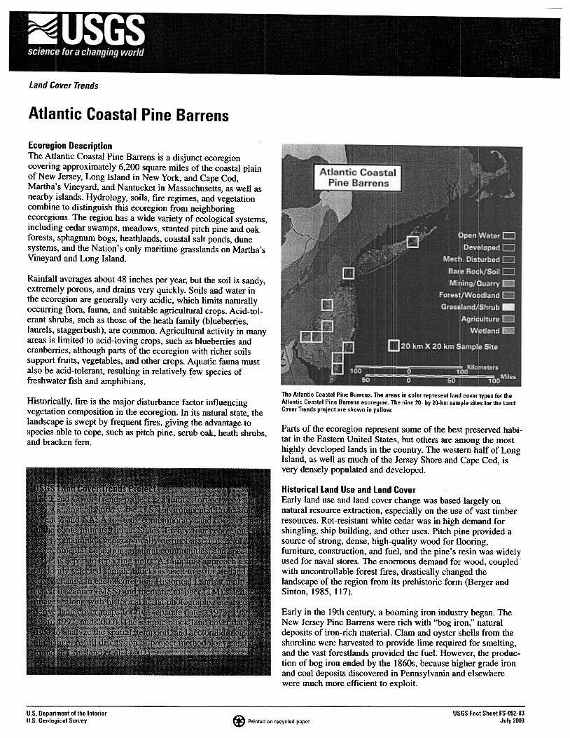
The Atlantic Coastal Pine Barrens. The areas in color represent land cover types for theAtlantic Coastal Pine Barrens ecoregion. The nine 20- hy 2O-km sample sites for the landCover Trends project are shown in yellow.
Historically, fire is the major disturbance factor influencingvegetation composition in the ecoregion. In its natural state, thelandscape is swept by frequent fires, giving the advantage tospecies able to cope, such as pitch pine, scrub oak, heath shrubs,and bracken fern.
Parts of the ecoregion represent some of the best preserved habi-tat in the Eastern United States, but others are among the mosthighly developed lands in the country. The western half of LongIsland, as well as much of the Jersey Shore and Cape Cod, isvery densely populated and developed.
Historical land Use and land CoverEarly land use and land cover change was based largely onnatural resource extraction, especially on the use of vast timberresources. Rot-resistant white cedar was in high demand forshingling, ship building, and other uses. Pitch pine provided asource of strong, dense, high-quality wood for flooring,furniture, construction, and fuel, and the pine's resin was widelyused for naval stores. The enormous demand for wood, coupledwith uncontrollable forest fires, drastically changed thelandscape of the region from its prehistoric form (Berger andSinton, 1985, 117).
Early in the 19th century, a booming iron industry began. TheNew Jersey Pine Barrens were rich with "bog iron," naturaldeposits of iron-rich material. Clam and oyster shells from theshoreline were harvested to provide lime required for smelting,and the vast forestlands provided the fuel. However, the produc-tion of bog iron ended by the 1860s, because higher grade ironand coal deposits discovered in Pennsylvania and elsewherewere much more efficient to exploit.
u.s. Depar1ment of the InteriorU.S. Geological Survey
USGS Fact Sheet FS-092-03July 2003(1) Printed on recycled paper
Glass industries also took advantage of the natural resources ofthe Pine Barrens. The quality of the sands, the abundance oftrees for fuel, and the proximity of large urban markets mademuch of the area ideal for the production of glass products.Twenty glass industries were established by 1800 in the NewJersey Pine Barrens alone, but all had closed by 1870.
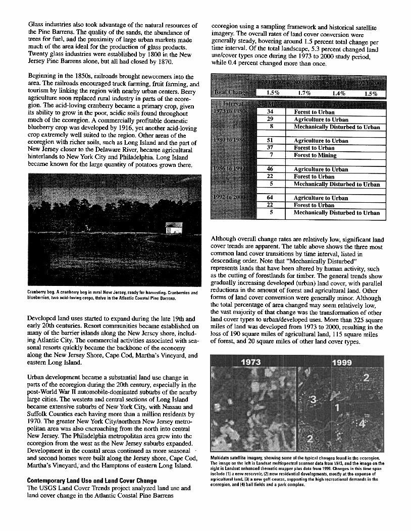
ecoregion using a sampling framework and historical satelliteimagery. The overall rates of land cover conversion weregenerally steady, hovering around 1.5 percent total change pertime interval. Of the total landscape, 5.3 percent changed landuse/cover types once during the 1973 to 2000 study period,while 0.4 percent changed more than once.
Beginning in the l850s, railroads brought newcomers into thearea. The railroads encouraged truck farming, fruit fanning, andtourism by linking the region with nearby urban centers. Berryagriculture soon replaced rural industry in parts of the ecore-gion. The acid-loving cranberry became a primary crop, givenits ability to grow in the poor, acidic soils found throughoutmuch of the ecoregion. A commercially profitable domesticblueberry crop was developed by 1916, yet another acid-lovingcrop extremely well suited to the region. Other areas of theecoregion with richer soils, such as Long Island and the part ofNew Jersey closer to the Delaware River, became agriculturalhinterlands to New York City and Philadelphia. Long Islandbecame known for the large quantity of potatoes grown there.
Although overall change rates are relatively low, significant landcover trends are apparent. The table above shows the three mostcommon land cover transitions by time interval, listed indescending order. Note that "Mechanically Disturbed"represents lands that have been altered by human activity, suchas the cutting of forestlands for timber. The general trends showgradually increasing developed (urban) land cover, with parallelreductions in the amount of forest and agricultural land. Otherforms of land cover conversion were generally minor. Althoughthe total percentage of area changed may seem relatively low,the vast majority of that change was the transformation of otherland cover types to urban/developed uses. More than 325 squaremiles of land was developed from 1973 to 2000, resulting in theloss of 190 square miles of agricultural land, 115 square milesof forest, and 20 square miles of other land cover types.
Cranberry bog. A cranberry bog in rural New Jersey, ready for harvesting. Cranberries andblueberries, two acid-loving crops, thrive in the Atlantic Coastal Pine Barrens.
Developed land uses started to expand during the late 19th andearly 20th centuries. Resort communities became established onmany of the barrier islands along the New Jersey shore, includ-ing Atlantic City. The commercial activities associated with sea-sonal resorts quickly became the backbone of the economyalong the New Jersey Shore, Cape Cod, Martha's Vineyard, andeastern Long Island.
Urban development became a substantial land use change inparts of the ecoregion during the 20th century, especially in thepost-World War II automobile-dominated suburbs of the nearbylarge cities. The westehI and central sections of Long Islandbecame extensive suburbs of New York City, with Nassau andSuffolk Counties each having more than a million residents by1970. The greater New York City/northern New Jersey metro-politan area was also encroaching from the north into centralNew Jersey. The Philadelphia metropolitan area grew into theecoregion from the west as the New Jersey suburbs expanded.Development in the coastal areas continued as more seasonal .and second homes were built along the Jersey shore, Cape Cod,Martha's Vineyard, and the Hamptons of eastern Long Island.
Multidate satellite imagery, showing some of the typical changes found in the ecoregion.The image on the left is landsat multispectral scanner data from 1973. and the image on theright is landsat enhanced thematic mapper plus data from 1999. Changes in this time spaninclude (1) a new reservoir, (2) new residential developments, mostly at the expense ofagriculluralland, (3) a new golf courSE'. supporting the high recreational demands in theecoregion, and (4) ball fields and a park complex.
Contemporary land Use and land Cover ChangeThe USGS Land Cover Trends project analyzed land use andland cover change in the Atlantic Coastal Pine Barrens
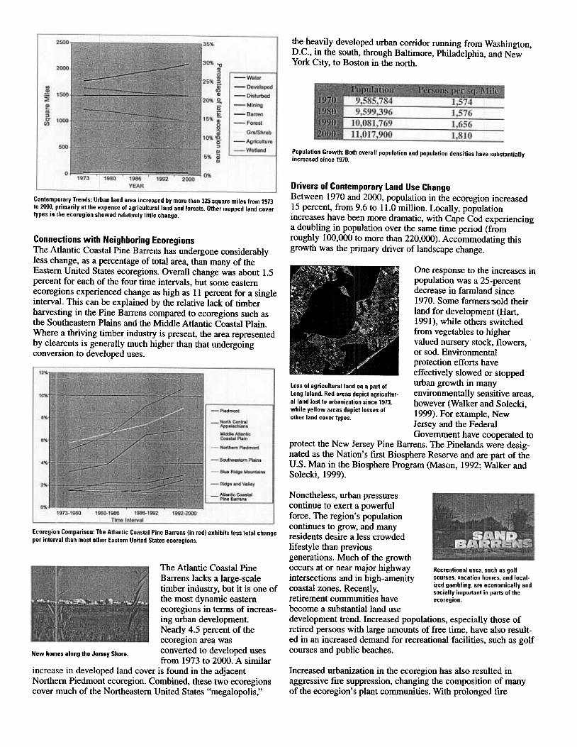
the heavily developed urban corridor running from Washington,D.C., in the south, through Baltimore, Philadelphia, and NewYork City, to Boston in the north.
Population Growth: Both overall population and population densities have substantiallyincreased since 1970.
Drivers of Contemporary land Use ChangeBetween 1970 and 2000, population in the ecoregion increased15 percent, from 9.6 to 11.0 million. Locally, populationincreases have been more dramatic, with Cape Cod experiencinga doubling in population over the same time period (fromroughly 100,000 to more than 220,000). Accommodating thisgrowth was the primary driver of landscape change.
Contemporary Trends: Urban land area increased by more than 325 square miles from 1973to 2000, Ilrimarily at the expense of agricultural land and forests. Other mapped land covertypes in the ecoregion showed relatively little change.
Connections with Neighboring EcoregionsThe Atlantic Coastal Pine Barrens has undergone considerablyless change, as a percentage of total area, than many of theEastern United States ecoregions. Overall change was about 1.5percent for each of the four time intervals, but some easternecoregions experienced change as high as 11 percent for a singleinterval. This can be explained by the relative lack of timberharvesting in the Pine Barrens compared to ecoregions such asthe Southeastern Plains and the Middle Atlantic Coastal Plain.Where a thriving timber industry is present, the area representedby clearcuts is generally much higher than that undergoingconversion to developed uses.
One response to the increases inpopulation was a 25-percentdecrease in farmland since1970. Some farmers .sold theirland for development (Hart,1991), while others switchedfrom vegetables to highervalued nursery stock, flowers,or sod. Environmentalprotection efforts haveeffectively slowed or stopped
Loss of agricultural land on a part of urb~ growth in man~ .Long Island. Red areas depict agricultur- enVIronmentally sensItive areas,alland lost to urbanization since 1973. however (Walker and Solecki,while yellow areas depict losses of 1999). For example Newother land cover types. J d F d '
alersey an the e erGovernment have cooperated to
protect the New Jersey Pine Barrens. The Pinelands were desig-nated as the Nation's first Biosphere Reserve and are part of theU.S. Man in the Biosphere Program (Mason, 1992; Walker andSolecki, 1999).
Ecoregiorl Comparison: The Atlantic Coastal Pine Barrens (in red) exhibits less total changeper interlral than most other Eastern United States ecoregions.
Nonetheless, urban pressurescontinue to exert a powerfulforce. The region's populationcontinues to grow, and manyresidents desire a less crowdedlifestyle than previousgenerations. Much of the growthoccurs at or near major highway Recreational uses, such as golfintersections and in high-amenity courses, vacation homes, and local-
ized gambling, are economically andcoastal zones. Recently, socially important in parts of the
retirement communities have ecoregion.
become a substantial land usedevelopment trend. Increased populations, especially those ofretired persons with large amounts of free time, have also result-ed in an increased demand for recreational facilities, such as golfcourses and public beaches.
The Atlantic Coastal PineBarrens lacks a large-scaletimber industry, but it is one ofthe most dynamic easternecoregions in terms of increas-ing urban development.Nearly 4.5 percent of theecoregion area was
N h I th J Sh converted to developed usesew ornes a ong e ersey ore.1from 1973 to 2000. A sirni ar
increase in developed land cover is found in the adjacentNorthern Piedmont ecoregion. Combined, these two ecoregionscover much of the Northeastern United States "megalopolis,"
Increased urbanization in the ecoregion has also resulted inaggressive fire suppression, changing the composition of manyof the ecoregion's plant communities. With prolonged fire
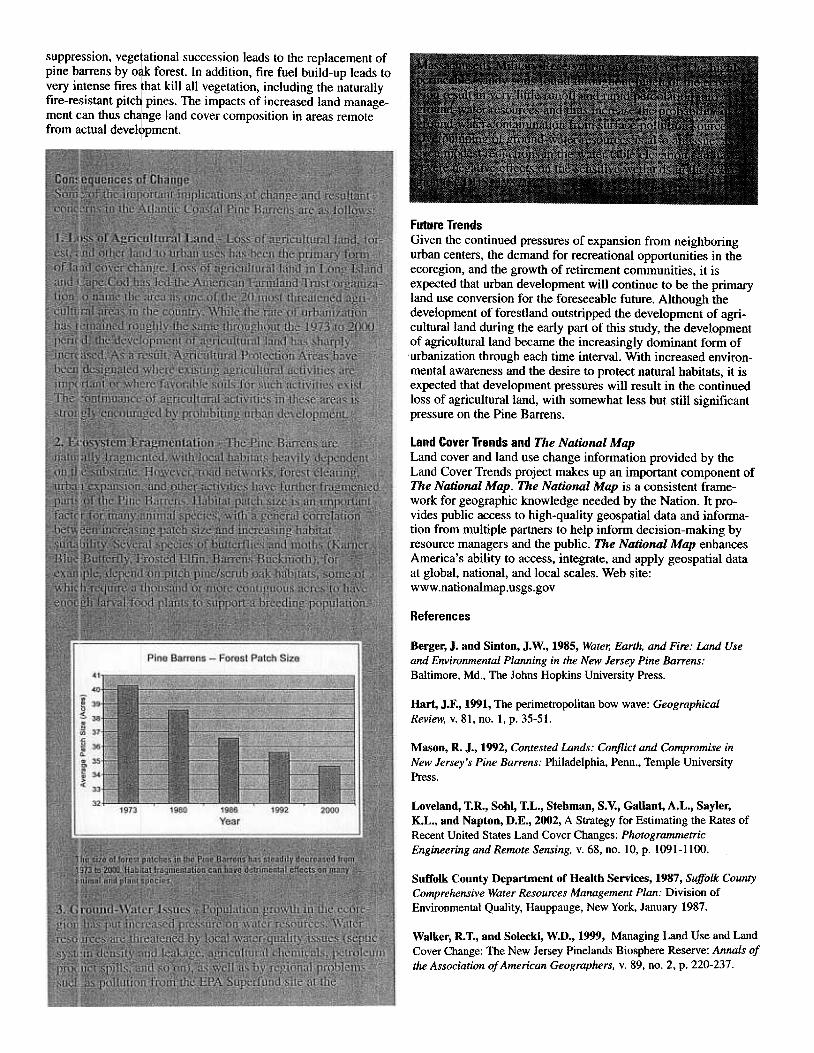
suppression, vege ational succession leads to the replacement ofpine barrens by 0 forest. In addition, fire fuel build-up leads tovery intense fires hat kill all vegetation, including the naturallyfire-resistant pitc pines. The impacts of increased land manage-ment can thus ch nge land cover composition in areas remotefrom actual devel pment.
Future TrendsGiven the continued pressures of expansion from neighboringurban centers, the demand for recreational opportunities in theecoregion, and the growth of retirement communities, it isexpected that urban development will continue to be the primaryland use conversion for the foreseeable future. Although thedevelopment of forestland outstripped the development of agri-cultural land during the early part of this study, the developmentof agricultural land became the increasingly dominant form of.urbanization through each time interval. With increased environ-mental awareness and the desire to protect natural habitats, it isexpected that development pressures will result in the continuedloss of agricultural land, with somewhat less but still significantpressure on the Pine Barrens.
land Cover Trends and The National MapLand cover and land use change infonnation provided by theLand Cover Trends project makes up an important component ofThe National Map. The National Map is a consistent frame-work for geographic knowledge needed by the Nation. It pro-vides public access to high-quality geospatial data and infonna-tion from multiple partners to help infonn decision-making byresource managers and the public. The National Map enhancesAmerica's ability to access, integrate, and apply geospatial dataat global, national, and local scales. Web site:www.nationalmap.usgs.gov
References
Berger, J. and Sinton, J. W., 1985, Wate1; Earth, and Fire: Land Useand Environmental Planning in the New Jersey Pine Barrens:Baltimore, Md., The Johns Hopkins University Press.
Hart, J.F., 1991, The perimetropolitan bow wave: GeographicalReview, v. 81, no. 1, p. 35-51.
Mason, R. J., 1992, Contested Lands: Conflict and Compromise inNew Jersey's Pine Barrens: Philadelphia, Penn., Temple UniversityPress.
Loveland, T.R., Sohl, T.L., Stehman, S. V., Gallant, A.L., Sayler,K.L., and Napton, D.E., 2002, A Strategy for Estimating the Rates ofRecent United States Land Cover Changes: PhotogrammetricEngineering and Remote Sensing, v. 68, no. 10, p. 1091-1100.
Suffolk County Department of Health Services, 1987, Suffolk CountyComprehensive Water Resources Management Plan: Division ofEnvironmental Quality, Hauppauge, New York, January 1987.
Walker, R.T., and Solecki, W.D., 1999, Managing Land Use and LandCover Change: The New Jersey Pinelands Biosphere Reserve: Annals ofthe Association of American Geographers, v. 89, no. 2, p. 220-237.