The Aqueduct of the Roman Town Salona – Croatia · PDF fileFigure 1 . Position of Salona...
10
The Aqueduct of the Roman Town Salona – Croatia K. Marasović*, J. Margeta*, S. Perojević*, M. Katić**, D. Bojanić* * University of Split, Faculty of Civil Engineering Architecture and Geodesy 21000 Split, Matice Hrvatske 15, Croatia (E-mail: [email protected]; [email protected]; [email protected]; [email protected]) ** Ministry of culture Republic of Croatia, Conservation Department in Trogir, 20220 Trogir, Gradska 41/2, Croatia (E-mail: [email protected]) Abstract This paper presents a study of The Aqueduct of Salona (capital of the Roman province Dalmatia) built in the 1st century BC. The aqueduct once transported water from the Jadro river spring, situated approximately 3 km east from the city. Even though it was built for the city of 15 ha in size, two centuries later it succeeded in managing the supply and demand of water for the city of 73 ha. In the 7th century Salona was destroyed by the Avars and Slavs, consequently aqueduct ceased to function. Due to intensive exploitation of marlstone and uncontrolled urbanization in the 20th century, some of the aqueduct sections were destroyed. The research of Salona and its aqueduct started as early as the mid-19th century, however, the aqueduct and its route have never been systematically explored until 2014/2015. This paper provides the results and findings of the latest research including the following: the route of the aqueduct, its longitudinal profile, capacity and typical cross-sections, and the method of construction in different terrain conditions. The channel was built in the usual manner in accordance with the practice of Roman builders, using local materials. Keywords Roman Aqueduct, Salona, Jadro river, reconstruction HISTORICAL OVERVIEW The ruins of the ancient city of Salona, the largest Roman city on the east Adriatic coast, are located 5 kilometers north of the city of Split, in the area of the town Solin (Figure 1). The city was built in a very convenient place: in the middle of the Adriatic coast, in a well-protected part of the Kaštela Bay, at the mouth of the river Jadro surrounded by large fertile fields. It is only 4 kilometers far from the passage to the inland and 3 kilometers far from the Jadro river spring, characterized by good water quality, large capacity and favorable elevation in relation to Salona. The earliest traces of human presence in Salona area date back to the late Bronze Age (Šuta, 2012). During the Iron Age the Jadro river mouth with the isle Vranjic was an important port and the point of contact of indigenous Illyrian tribe Delmatae with Mediterranean world. Delmatian fortified settlements were located on elevated positions around the port (Katić, 2010).
-
Upload
vuongkhuong -
Category
Documents
-
view
216 -
download
1
Transcript of The Aqueduct of the Roman Town Salona – Croatia · PDF fileFigure 1 . Position of Salona...
The Aqueduct of the Roman Town Salona – Croatia K. Marasović*, J. Margeta*, S. Perojević*, M. Katić**, D. Bojanić* * University of Split, Faculty of Civil Engineering Architecture and Geodesy 21000 Split, Matice Hrvatske 15, Croatia (E-mail: [email protected]; [email protected]; [email protected]; [email protected]) ** Ministry of culture Republic of Croatia, Conservation Department in Trogir, 20220 Trogir, Gradska 41/2, Croatia (E-mail: [email protected]) Abstract This paper presents a study of The Aqueduct of Salona (capital of the Roman province Dalmatia) built in the 1st century BC. The aqueduct once transported water from the Jadro river spring, situated approximately 3 km east from the city. Even though it was built for the city of 15 ha in size, two centuries later it succeeded in managing the supply and demand of water for the city of 73 ha. In the 7th century Salona was destroyed by the Avars and Slavs, consequently aqueduct ceased to function. Due to intensive exploitation of marlstone and uncontrolled urbanization in the 20th century, some of the aqueduct sections were destroyed. The research of Salona and its aqueduct started as early as the mid-19th century, however, the aqueduct and its route have never been systematically explored until 2014/2015. This paper provides the results and findings of the latest research including the following: the route of the aqueduct, its longitudinal profile, capacity and typical cross-sections, and the method of construction in different terrain conditions. The channel was built in the usual manner in accordance with the practice of Roman builders, using local materials. Keywords Roman Aqueduct, Salona, Jadro river, reconstruction
HISTORICAL OVERVIEW The ruins of the ancient city of Salona, the largest Roman city on the east Adriatic coast, are located 5 kilometers north of the city of Split, in the area of the town Solin (Figure 1). The city was built in a very convenient place: in the middle of the Adriatic coast, in a well-protected part of the Kaštela Bay, at the mouth of the river Jadro surrounded by large fertile fields. It is only 4 kilometers far from the passage to the inland and 3 kilometers far from the Jadro river spring, characterized by good water quality, large capacity and favorable elevation in relation to Salona. The earliest traces of human presence in Salona area date back to the late Bronze Age (Šuta, 2012). During the Iron Age the Jadro river mouth with the isle Vranjic was an important port and the point of contact of indigenous Illyrian tribe Delmatae with Mediterranean world. Delmatian fortified settlements were located on elevated positions around the port (Katić, 2010).

Figure 1. Position of Salona in the middle of east Adriatic coast The earliest mention of Salona, in written records, dates back 119 BC, when the consul Lucius Caecilius Metellus with his army spent the winter there after taking Siscia. The oldest nucleus of the city, the so-called "Urbs Quadrata", was located to west of the mouth of the river Jadro and had a trapezium shaped plan of 15 ha. As the capital of the Roman province Dalmatia, Salona underwent a significant development after 9 AD when the Romans finally defeated the last Delmatian uprising after which the pacification of Illyricum started. The city gradually spread to the east and west of the old nucleus forming the large suburbs which were surrounded by defensive walls and towers in the 2nd century, during the invasion of Quadi and Marcomanni. The area of the city within the walls expanded to 73 ha. In subsequent centuries the size of the city did not change, but in the 6th century, due to new enemy penetration from the north, the city walls were reinforced and the new towers were built (Figure 2). In the 7th century the city was destroyed by Avars and Slavs, the population fled to the islands and some of them settled inside the safe walls of nearby Diocletian's Palace, laying the foundations of the medieval town of Split. Salona was never reconstructed again. As the capital, Salona was the administrative center of great Dalmatia - in that time 7.5 time bigger than today. During the rule of Augustus and Tiberius, a regional road network was built, starting from Salona. The economy was based on agriculture and farming, but also on fishing, crafts and maritime affairs. The Dalmatian inland (present-day Bosnia and Herzegovina) was known for its richness in iron, lead and silver which were exported through Salona port. According to some assumptions, at its peak Salona had 60,000 inhabitants.
Figure 2. Map of Salona (Authors)
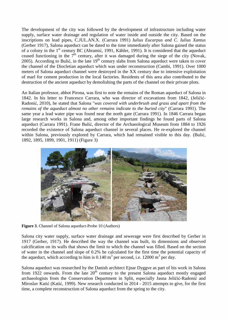
The development of the city was followed by the development of infrastructure including water supply, surface water drainage and regulation of water inside and outside the city. Based on the inscriptions on lead pipes, C.JUL.AN.X. (Carrara 1991) Iulius Eucarpus and C. Iulius Xantus (Gerber 1917), Salona aqueduct can be dated to the time immediately after Salona gained the status of a colony in the 1st century BC (Abramić, 1991, Kähler, 1991). It is considered that the aqueduct ceased functioning in the 7th century, after it was damaged during the siege of the city (Novak, 2005). According to Bulić, in the late 19th century slabs from Salona aqueduct were taken to cover the channel of the Diocletian aqueduct which was under reconstruction (Cambi, 1991). Over 1000 meters of Salona aqueduct channel were destroyed in the XX century due to intensive exploitation of marl for cement production in the local factories. Residents of this area also contributed to the destruction of the ancient aqueduct by demolishing the parts of the channel on their private plots. An Italian professor, abbot Pirona, was first to note the remains of the Roman aqueduct of Salona in 1842. In his letter to Francesco Carrara, who was director of excavations from 1842, (Jeličić-Radonić, 2010), he stated that Salona "was covered with underbrush and grass and apart from the remains of the aqueduct almost no other remains indicate to the buried city" (Carrara 1991). The same year a lead water pipe was found near the north gate (Carrara 1991). In 1846 Carrara began large research works in Salona and, among other important findings he found parts of Salona aqueduct (Carrara 1991). Frane Bulić, director of the Archaeological Museum from 1884 to 1926 recorded the existence of Salona aqueduct channel in several places. He re-explored the channel within Salona, previously explored by Carrara, which had remained visible to this day. (Bulić, 1892, 1895, 1899, 1901, 1911) (Figure 3)
Figure 3. Channel of Salona aqueduct-Probe 10 (Authors)
Salona city water supply, surface water drainage and sewerage were first described by Gerber in 1917 (Gerber, 1917). He described the way the channel was built, its dimensions and observed calcification on its walls that shows the limit to which the channel was filled. Based on the section of water in the channel and slope of 0.2% he calculated for the first time the potential capacity of the aqueduct, which according to him is 0.140 m3 per second, i.e. 12000 m3 per day. Salona aqueduct was researched by the Danish architect Ejnar Dyggve as part of his work in Salona from 1922 onwards. From the late 20th century to the present Salona aqueduct mostly engaged archaeologists from the Conservation Department in Split, especially Jasna Jeličić-Radonić and Miroslav Katić (Katić, 1999). New research conducted in 2014 - 2015 attempts to give, for the first time, a complete reconstruction of Salona aqueduct from the spring to the city.
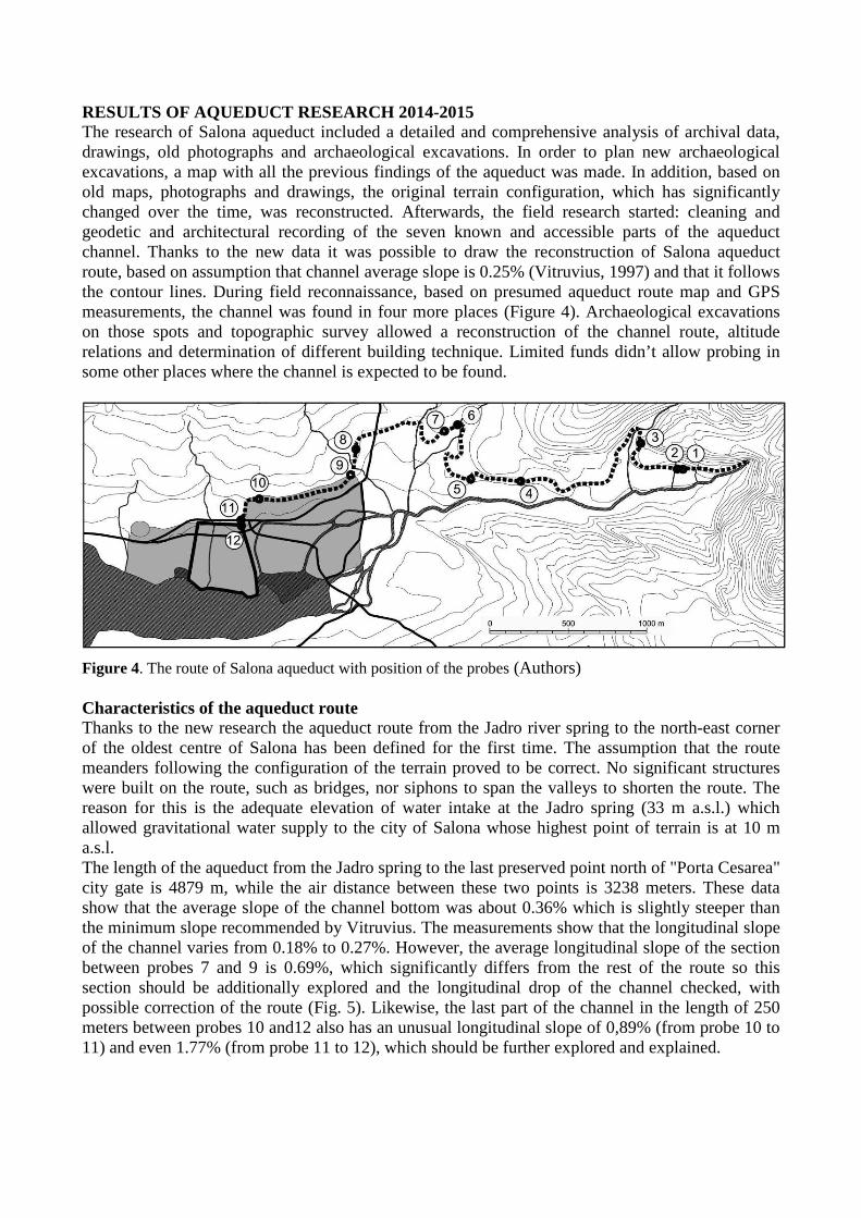
RESULTS OF AQUEDUCT RESEARCH 2014-2015 The research of Salona aqueduct included a detailed and comprehensive analysis of archival data, drawings, old photographs and archaeological excavations. In order to plan new archaeological excavations, a map with all the previous findings of the aqueduct was made. In addition, based on old maps, photographs and drawings, the original terrain configuration, which has significantly changed over the time, was reconstructed. Afterwards, the field research started: cleaning and geodetic and architectural recording of the seven known and accessible parts of the aqueduct channel. Thanks to the new data it was possible to draw the reconstruction of Salona aqueduct route, based on assumption that channel average slope is 0.25% (Vitruvius, 1997) and that it follows the contour lines. During field reconnaissance, based on presumed aqueduct route map and GPS measurements, the channel was found in four more places (Figure 4). Archaeological excavations on those spots and topographic survey allowed a reconstruction of the channel route, altitude relations and determination of different building technique. Limited funds didn’t allow probing in some other places where the channel is expected to be found.
Figure 4. The route of Salona aqueduct with position of the probes (Authors) Characteristics of the aqueduct route Thanks to the new research the aqueduct route from the Jadro river spring to the north-east corner of the oldest centre of Salona has been defined for the first time. The assumption that the route meanders following the configuration of the terrain proved to be correct. No significant structures were built on the route, such as bridges, nor siphons to span the valleys to shorten the route. The reason for this is the adequate elevation of water intake at the Jadro spring (33 m a.s.l.) which allowed gravitational water supply to the city of Salona whose highest point of terrain is at 10 m a.s.l. The length of the aqueduct from the Jadro spring to the last preserved point north of "Porta Cesarea" city gate is 4879 m, while the air distance between these two points is 3238 meters. These data show that the average slope of the channel bottom was about 0.36% which is slightly steeper than the minimum slope recommended by Vitruvius. The measurements show that the longitudinal slope of the channel varies from 0.18% to 0.27%. However, the average longitudinal slope of the section between probes 7 and 9 is 0.69%, which significantly differs from the rest of the route so this section should be additionally explored and the longitudinal drop of the channel checked, with possible correction of the route (Fig. 5). Likewise, the last part of the channel in the length of 250 meters between probes 10 and12 also has an unusual longitudinal slope of 0,89% (from probe 10 to 11) and even 1.77% (from probe 11 to 12), which should be further explored and explained.
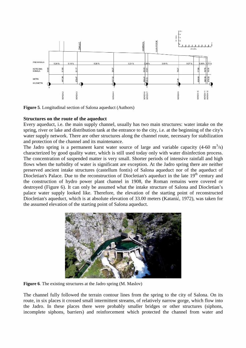
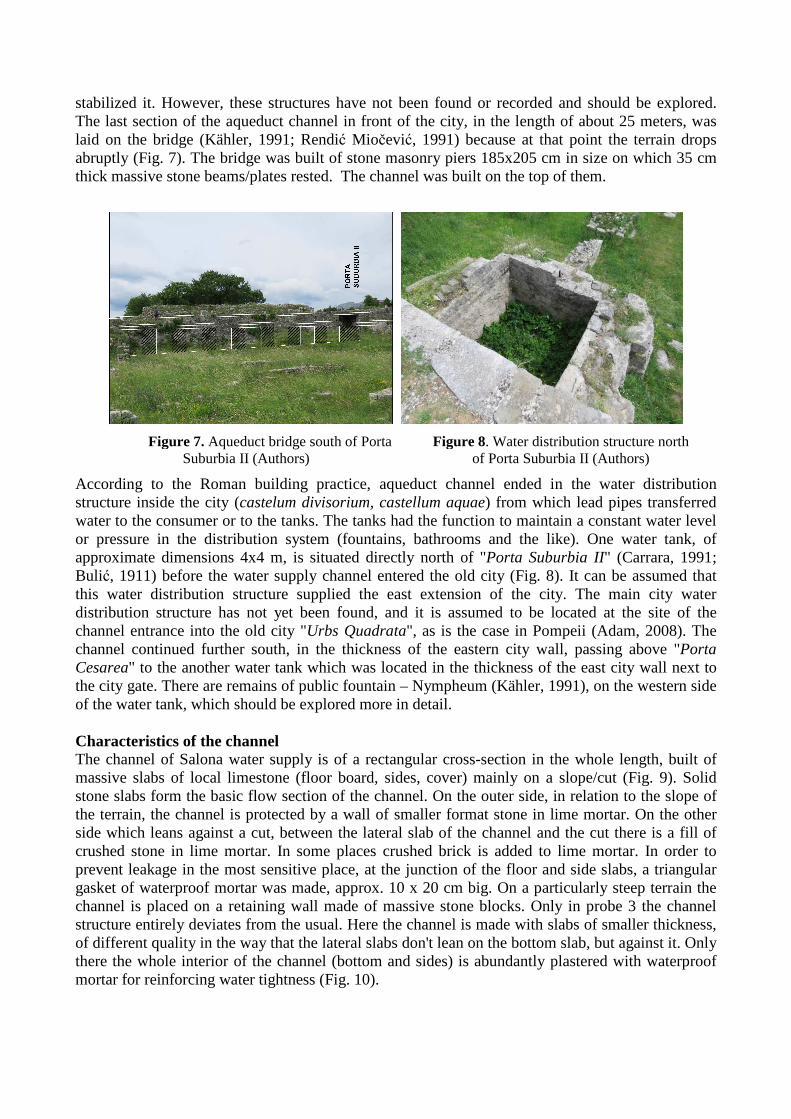
Figure 5. Longitudinal section of Salona aqueduct (Authors) Structures on the route of the aqueduct Every aqueduct, i.e. the main supply channel, usually has two main structures: water intake on the spring, river or lake and distribution tank at the entrance to the city, i.e. at the beginning of the city's water supply network. There are other structures along the channel route, necessary for stabilization and protection of the channel and its maintenance. The Jadro spring is a permanent karst water source of large and variable capacity (4-60 m3/s) characterized by good quality water, which is still used today only with water disinfection process. The concentration of suspended matter is very small. Shorter periods of intensive rainfall and high flows when the turbidity of water is significant are exception. At the Jadro spring there are neither preserved ancient intake structures (castellum fontis) of Salona aqueduct nor of the aqueduct of Diocletian's Palace. Due to the reconstruction of Diocletian's aqueduct in the late 19th century and the construction of hydro power plant channel in 1908, the Roman remains were covered or destroyed (Figure 6). It can only be assumed what the intake structure of Salona and Diocletian’s palace water supply looked like. Therefore, the elevation of the starting point of reconstructed Diocletian's aqueduct, which is at absolute elevation of 33.00 meters (Katanić, 1972), was taken for the assumed elevation of the starting point of Salona aqueduct.
Figure 6. The existing structures at the Jadro spring (M. Maslov)
The channel fully followed the terrain contour lines from the spring to the city of Salona. On its route, in six places it crossed small intermittent streams, of relatively narrow gorge, which flow into the Jadro. In these places there were probably smaller bridges or other structures (siphons, incomplete siphons, barriers) and reinforcement which protected the channel from water and
stabilized it. However, these structures have not been found or recorded and should be explored. The last section of the aqueduct channel in front of the city, in the length of about 25 meters, was laid on the bridge (Kähler, 1991; Rendić Miočević, 1991) because at that point the terrain drops abruptly (Fig. 7). The bridge was built of stone masonry piers 185x205 cm in size on which 35 cm thick massive stone beams/plates rested. The channel was built on the top of them.
Figure 7. Aqueduct bridge south of Porta
Suburbia II (Authors) Figure 8. Water distribution structure north
of Porta Suburbia II (Authors)
According to the Roman building practice, aqueduct channel ended in the water distribution structure inside the city (castelum divisorium, castellum aquae) from which lead pipes transferred water to the consumer or to the tanks. The tanks had the function to maintain a constant water level or pressure in the distribution system (fountains, bathrooms and the like). One water tank, of approximate dimensions 4x4 m, is situated directly north of "Porta Suburbia II" (Carrara, 1991; Bulić, 1911) before the water supply channel entered the old city (Fig. 8). It can be assumed that this water distribution structure supplied the east extension of the city. The main city water distribution structure has not yet been found, and it is assumed to be located at the site of the channel entrance into the old city "Urbs Quadrata", as is the case in Pompeii (Adam, 2008). The channel continued further south, in the thickness of the eastern city wall, passing above "Porta Cesarea" to the another water tank which was located in the thickness of the east city wall next to the city gate. There are remains of public fountain – Nympheum (Kähler, 1991), on the western side of the water tank, which should be explored more in detail. Characteristics of the channel The channel of Salona water supply is of a rectangular cross-section in the whole length, built of massive slabs of local limestone (floor board, sides, cover) mainly on a slope/cut (Fig. 9). Solid stone slabs form the basic flow section of the channel. On the outer side, in relation to the slope of the terrain, the channel is protected by a wall of smaller format stone in lime mortar. On the other side which leans against a cut, between the lateral slab of the channel and the cut there is a fill of crushed stone in lime mortar. In some places crushed brick is added to lime mortar. In order to prevent leakage in the most sensitive place, at the junction of the floor and side slabs, a triangular gasket of waterproof mortar was made, approx. 10 x 20 cm big. On a particularly steep terrain the channel is placed on a retaining wall made of massive stone blocks. Only in probe 3 the channel structure entirely deviates from the usual. Here the channel is made with slabs of smaller thickness, of different quality in the way that the lateral slabs don't lean on the bottom slab, but against it. Only there the whole interior of the channel (bottom and sides) is abundantly plastered with waterproof mortar for reinforcing water tightness (Fig. 10).
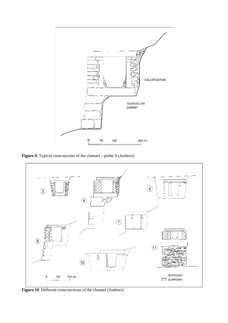
Figure 9. Typical cross-section of the channel – probe 9 (Authors)
Figure 10. Different cross-sections of the channel (Authors)
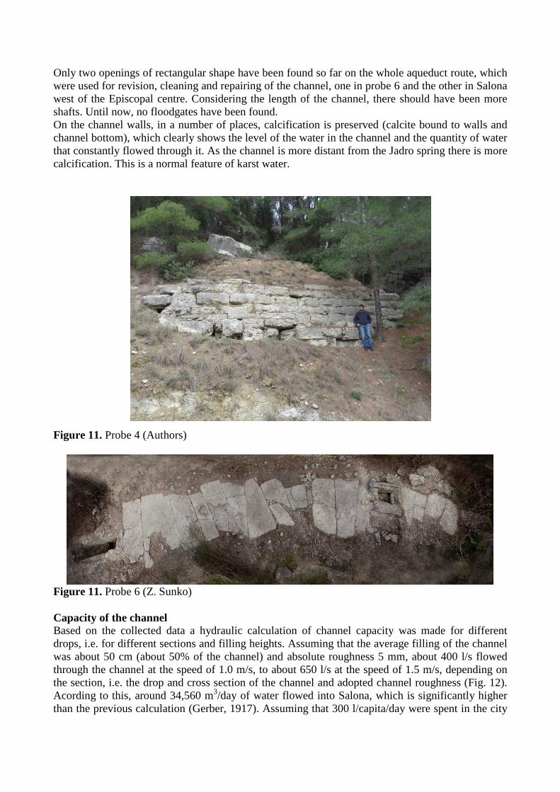
Only two openings of rectangular shape have been found so far on the whole aqueduct route, which were used for revision, cleaning and repairing of the channel, one in probe 6 and the other in Salona west of the Episcopal centre. Considering the length of the channel, there should have been more shafts. Until now, no floodgates have been found. On the channel walls, in a number of places, calcification is preserved (calcite bound to walls and channel bottom), which clearly shows the level of the water in the channel and the quantity of water that constantly flowed through it. As the channel is more distant from the Jadro spring there is more calcification. This is a normal feature of karst water.
Figure 11. Probe 4 (Authors)
Figure 11. Probe 6 (Z. Sunko) Capacity of the channel Based on the collected data a hydraulic calculation of channel capacity was made for different drops, i.e. for different sections and filling heights. Assuming that the average filling of the channel was about 50 cm (about 50% of the channel) and absolute roughness 5 mm, about 400 l/s flowed through the channel at the speed of 1.0 m/s, to about 650 l/s at the speed of 1.5 m/s, depending on the section, i.e. the drop and cross section of the channel and adopted channel roughness (Fig. 12). Acording to this, around 34,560 m3/day of water flowed into Salona, which is significantly higher than the previous calculation (Gerber, 1917). Assuming that 300 l/capita/day were spent in the city
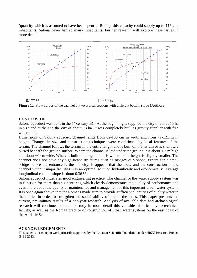
(quantity which is assumed to have been spent in Rome), this capacity could supply up to 115,200 inhabitants. Salona never had so many inhabitants. Further research will explore these issues in more detail.
I = 0.177 % I=0.69 % Figure 12. Flow curves of the channel at two typical sections with different bottom slope (Authors) CONCLUSION Salona aqueduct was built in the 1st century BC. At the beginning it supplied the city of about 15 ha in size and at the end the city of about 73 ha. It was completely built as gravity supplier with free water table. Dimensions of Salona aqueduct channel range from 62-100 cm in width and from 72-121cm in height. Changes in size and construction techniques were conditioned by local features of the terrain. The channel follows the terrain in the entire length and is built on the terrain or is shallowly buried beneath the ground surface. Where the channel is laid under the ground it is about 1.2 m high and about 60 cm wide. Where is built on the ground it is wider and its height is slightly smaller. The channel does not have any significant structures such as bridges or siphons, except for a small bridge before the entrance to the old city. It appears that the route and the construction of the channel without major facilities was an optimal solution hydraulically and economically. Average longitudinal channel slope is about 0.36 %. Salona aqueduct illustrates good engineering practice. The channel or the water supply system was in function for more than six centuries, which clearly demonstrates the quality of performance and even more about the quality of maintenance and management of this important urban water system. It is once again shown that the Romans made sure to provide sufficient quantities of quality water to their cities in order to strengthen the sustainability of life in the cities. This paper presents the current, preliminary results of a one-year research. Analysis of available data and archaeological research will continue in order to study in more detail this valuable historical hydro-technical facility, as well as the Roman practice of construction of urban water systems on the east coast of the Adriatic Sea. ACKNOWLEDGEMENTS This paper is based upon work primarily supported by the Croatian Scientific Foundation under HRZZ Research Project IP-11-2013.
0.0
0.1
0.2
0.3
0.4
0.5
0.6
0.7
0.8
0.9
1.0
0.0
0.2
0.4
0.6
0.8
1.0
1.2
1.4
1.6
1.8
2.0
0 200 400 600 800 1000Q (l/s)
y (m)
FLOW CURVE
VELOCITIES
v (m/s)Io=0.17741%b=0.79 (m)k=5 (mm)
0.0
0.1
0.2
0.3
0.4
0.5
0.6
0.7
0.8
0.9
1.0
0.0
0.3
0.6
0.9
1.2
1.5
1.8
2.1
2.4
2.7
3.0
0 200 400 600 800 1000 1200 1400 1600Q (l/s)
y (m)
FLOW CURVE
VELOCITIES
v (m/s)SALONAS AQUEDUCT
SECTION 6FROM CHAINAGE 3+048.53 TO 4+004.36
For y=0.57 (m)Q=774 (l/s)
For y=1.00 (m)Q=1528(l/s)
REFERENCES Abramić M. 1991 O povijesti Salone, Antička Salona, ed. N. Cambi, Split 1991, 39-46.
Adam J-P. 2008, Le castellum aquae de Pompéi, étude architecturale, Revue archéologique 2008/1 (n° 45), Paris, 37-72.
Bulić F. 1892, Ritrovamenti risguardanti la topografia urbana dell' antica Salona, Bullettino di archeologia e storia dalmata, XV, Split, 53-54.
Bulić F. 1895, Ritrovamenti risguardanti la topografia urbana dell' antica Salona, Bullettino di archeologia e storia dalmata, XVIII, Split, 78.
Bulić F. 1899, Ritrovamenti risguardanti la topografia urbana dell' antica Salona, XXII, Split, 244.
Bulić F. 1901, Ritrovamenti antici nella campagna di Clissa, Bullettino di archeologia e storia dalmata, XXIV, Split, 176.
Bulić F. 1911, Trovamenti riguardanti l'acquedotto urbano di Salona, Bullettino di archeologia e storia dalmata, XXXIV, Split, 66-68.
Cambi N. 1991, Predgovor, Antička Salona, ed. N. Cambi, Split, 7-36..
Carrara F. 1991, Topografija i iskapanja Salone, Antička Salona, ed. N. Cambi, Split 1991, 99-192.
Gerber E W. 1917, Forschungen in Salona I, Wien.
Jeličić-Radonić J., Pereža D. 2010, Topografija antičke Salone (II), Istraživači Salone u XIX. stoljeću, Tusculum 3, Solin, 167-203
Kähler H. 1991, Porta Cesarea u Saloni, Antička Salona, ed. N. Cambi, Split, 205-240.
Katanić N., Gojković M. 1972, Građa za proučavanje starih kamenih mostova i akvedukata u Hrvatskoj, Beograd-Zagreb.
Katić M. 1999, Salonitanski vodovod, Dioklecijanov akvedukt, ed. J. Belamarić, Split., str 58-63
Katić M. 2010, Prethistorijske gradine solinskoga i kliškoga područja, Tusculum 3, Solin, 7-19
Novak G. 2005, Povijest Splita, Split.
Rendić Miočević D. 1991, Salona „Quadrata“, Salonitanski oppidum (Caes., B.C. III 9) u svjetlu novih istraživanja, Antička Salona, Split, 47-
Šuta I. 2012, Topografija kasnorepublikanske Salone u kontekstu novih nalaza iz Bencunuša, Tusculum 5, Solin, 154
Vitruvius Pollio M. 1997, De archtitectura libri decem, Preveo Matija Lopac, Zagreb.