
Imagine that you are an African American living in Macon County, Alabama during the Depression…
AWRCOralandPosterPresentations
Page 1 2017 Alabama Water Resources Conference
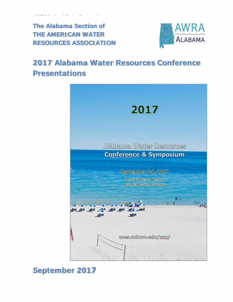
The Alabama Section of THE AMERICAN WATER RESOURCES ASSOCIATION
2017 Alabama Water Resources Conference Presentations
September 2017

AWRCOralandPosterPresentations
Page 2 2017 Alabama Water Resources Conference
Alabama Section of the American Water Resources Association Symposium Program
Wednesday, September 6, 2017
Theme: Effective Water Resources Communication
Registration Open – (Lobby)
Welcome & Introduction – (Salons E‐H) Kenneth Odom, PE, PhD, Southern Company, AWRA President
Overview of Symposium Eve Brantley, PhD, Alabama Cooperative Extension System, President Elect, AWRA
Influencing Positive Change Barry Fagan, PE/PLS, ENV SP, CPMSM CPESC, Volkert, Inc.
Building Blocks for a Community Watershed Jonika Smith, Jefferson County Dept. of Public Health’s Watershed Protection Program, Education and Outreach
NETWORKING BREAK
Commercials, Songs and Everybody’s an Expert: Thoughts on the communication of science Matt Waters, PhD, Auburn University
Getting Stakeholders to the Table and Keeping Them Engaged Sabra Sutton, CH2M
A Picture is Worth More Than a Thousand Words: Communication through art
Wrap Up and Adjournment Kenneth Odom, PE, PhD, Southern Company, AWRA President
2017 AWRC Sponsors
Alabama A&M University Alabama Cooperative System, SerPIE Program
Samford University Masters of Science in Environmental Management
Alabama Coal Association Hargrove Environmental & Constructors
Alabama Power Company Normandeau Associates
Alabama Pulp and Paper Council Ott Hydromet and Hydrolab
Amec Foster Wheeler PowerSouth Energy
Balch & Bingham, LLP
CH2M Trutta Environmental Solutions
Drummond Company UA SafeState
Eureka Water Probes Flexamat
Kleinschmidt – Energy & Water Resource Consultants
University of Alabama Research and Economic Development Water Policy and Law Institute

AWRCOralandPosterPresentations
2017 Alabama Water Resources Conference Page 3
AWRC Conference Program Session Topics and Presenters
Thursday, September 7, 2017
Ballroom D – Session One: Watershed Management
Have the local government entities involved in water resources management evolved over the period 1990 to the present day? Have their changing roles influenced the development of water policy in the state? Mary Wallace Pitts, University of Alabama
Growing and Maintaining a Vibrant Watershed Group in North Central Alabama Kevin Jenne, Watershed Coordinator, Choccolocco Creek Watershed
Implementation Assessment for Water Resource Availability, Protection, and Utilization for the Choctawhatchee, Pea and Yellow Rivers Watersheds Barbara Gibson, Choctawhatchee, Pea and Yellow Rivers Watershed Management Authority
What Difference Does a Year Make? The influence of drought periods on low flow statistics and water quality trends Lynn Sisk, TTL, Inc.
Ballroom E – Session One: Aquatic Ecology/Biology
Quantification of Functional Marker Genes for Denitrifying Microbial Populations in the Chandeleur Islands Impacted by the 2010 Gulf of Mexico Oil Spill Nikaela Flournoy, University of Alabama
Non‐Lethal Estimation of Proximate Body Composition of Channel Catfish Using Bioelectrical Impedance Analysis Julie Sharp, University of Alabama
Estimating Nitrogen Removal Services of Eastern Oyster in Mobile Bay, Alabama Quan Lai, Auburn University
Macroinvertebrate Community Response to Drought Years in Regulated and Unregulated Reaches of the Tallapoosa River, Alabama Kristie Ouellette, Alabama Cooperative Fish and Wildlife Research Unit
Ballroom F‐H – Session One: Water Quantity
Limits to Water Entrepreneurship and How to Overcome Them: A case analysis Craig Armstrong, University of Alabama
EPA’s Water Conservation & Efficiency Best Practices (formerly Region 4’s Water Efficiency Guidelines) Rosemary (Hall) Calli, Aquatic Ecotoxicologist, EPA Region 4
Updating Low‐Flow Frequency and Flow‐Duration Statistics in Alabama Toby Feaster, U.S. Geological Survey
Hydrologic Classification of Alabama Rivers Based on Cluster Analysis of Dimensionless Signatures Sarah Praskievicz, University of Alabama

AWRCOralandPosterPresentations
Page 4 2017 Alabama Water Resources Conference
Ballroom D – Session Two: Water Policy/Law
Aftermath: Water policy implications of Florida v. Georgia Bennett Bearden, Water Policy and Law Institute, University of Alabama
Multi‐Decadal Decline of Alabama Streamflow Glenn Tootle, University of Alabama
A Paleohydroclimate Perspective on Alabama Water Policy Matthew Therrell, University of Alabama
Bridging Water Policy and Aquatic Species Conservation: What we have learned from a two‐inch fish Patrick O'Neil, Geological Survey of Alabama
Ballroom E – Session Two: Drought/Climate Issues
Past and Future Predicted Effects of Sea Level Rise and Human Activities on Habitats and Shorelines in Coastal Alabama’s Weeks Bay Watershed Scott Jackson, Ecology and Environment, Inc.
Land‐Atmosphere Coupling and Soil Moisture Memory Contribute to Long‐Term Agricultural Drought Sanjiv Kumar, Auburn University
Development of Bivariate and Multivariate Coastal Drought Index: A comprehensive drought assessment tool for coastal areas, bays and estuaries Subhasis Mitra, Auburn University
Medium Range Forecasting of Reference Evapotranspiration in Continental U.S. Using Numerical Weather Predictions Hanoi Medina, Auburn University
Ballroom F‐H – Session Two: Weeks Bay Session
Creating a Clean Water Future for the Weeks Bay Watershed Roberta Swann, Mobile Bay National Estuary Program
Weeks Bay Watershed Hydrologic and Water Quality Modeling Latif Kalin, Auburn University
Weeks Bay Watershed Management Plan: Overview of watershed conditions and water quality John Carlton, Double J Farms
Ecosystem Review and Analysis for the Weeks Bay Watershed Management Plan Tim Thibaut, Barry A. Vittor & Associates, Inc.
Management Recommendations for the Weeks Bay Watershed Management Plan Michael Eubanks, Thompson Engineering, Inc.
AWRCOralandPosterPresentations
2017 Alabama Water Resources Conference Page 5
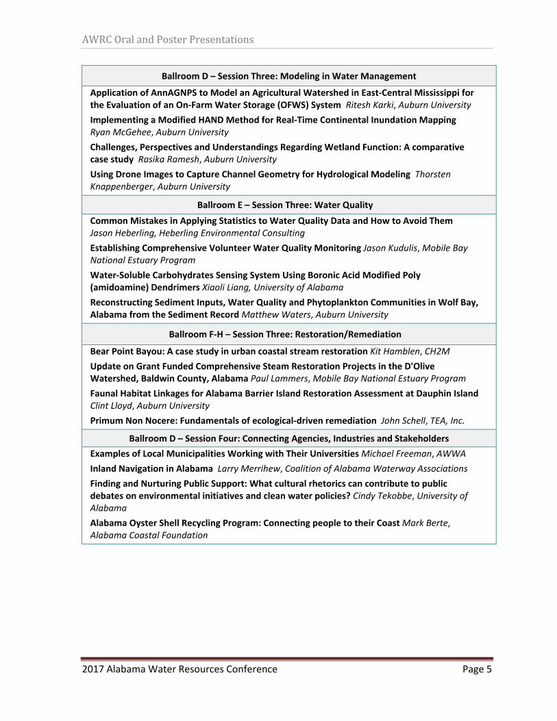
Ballroom D – Session Three: Modeling in Water Management
Application of AnnAGNPS to Model an Agricultural Watershed in East‐Central Mississippi for the Evaluation of an On‐Farm Water Storage (OFWS) System Ritesh Karki, Auburn University
Implementing a Modified HAND Method for Real‐Time Continental Inundation Mapping Ryan McGehee, Auburn University
Challenges, Perspectives and Understandings Regarding Wetland Function: A comparative case study Rasika Ramesh, Auburn University
Using Drone Images to Capture Channel Geometry for Hydrological Modeling Thorsten Knappenberger, Auburn University
Ballroom E – Session Three: Water Quality
Common Mistakes in Applying Statistics to Water Quality Data and How to Avoid Them Jason Heberling, Heberling Environmental Consulting
Establishing Comprehensive Volunteer Water Quality Monitoring Jason Kudulis, Mobile Bay National Estuary Program
Water‐Soluble Carbohydrates Sensing System Using Boronic Acid Modified Poly (amidoamine) Dendrimers Xiaoli Liang, University of Alabama
Reconstructing Sediment Inputs, Water Quality and Phytoplankton Communities in Wolf Bay, Alabama from the Sediment Record Matthew Waters, Auburn University
Ballroom F‐H – Session Three: Restoration/Remediation
Bear Point Bayou: A case study in urban coastal stream restoration Kit Hamblen, CH2M
Update on Grant Funded Comprehensive Steam Restoration Projects in the D'Olive Watershed, Baldwin County, Alabama Paul Lammers, Mobile Bay National Estuary Program
Faunal Habitat Linkages for Alabama Barrier Island Restoration Assessment at Dauphin Island Clint Lloyd, Auburn University
Primum Non Nocere: Fundamentals of ecological‐driven remediation John Schell, TEA, Inc.
Ballroom D – Session Four: Connecting Agencies, Industries and Stakeholders
Examples of Local Municipalities Working with Their Universities Michael Freeman, AWWA
Inland Navigation in Alabama Larry Merrihew, Coalition of Alabama Waterway Associations
Finding and Nurturing Public Support: What cultural rhetorics can contribute to public debates on environmental initiatives and clean water policies? Cindy Tekobbe, University of Alabama
Alabama Oyster Shell Recycling Program: Connecting people to their Coast Mark Berte, Alabama Coastal Foundation
AWRCOralandPosterPresentations
Page 6 2017 Alabama Water Resources Conference
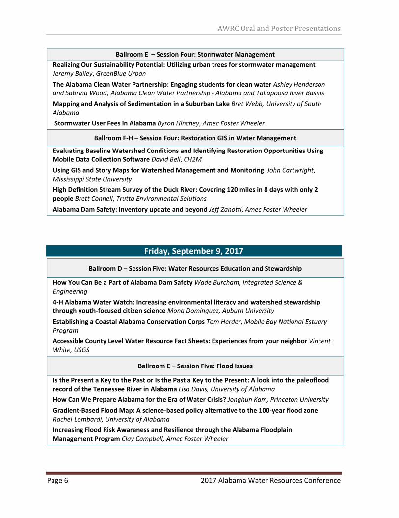
Ballroom E – Session Four: Stormwater Management
Realizing Our Sustainability Potential: Utilizing urban trees for stormwater management Jeremy Bailey, GreenBlue Urban
The Alabama Clean Water Partnership: Engaging students for clean water Ashley Henderson and Sabrina Wood, Alabama Clean Water Partnership ‐ Alabama and Tallapoosa River Basins
Mapping and Analysis of Sedimentation in a Suburban Lake Bret Webb, University of South Alabama
Stormwater User Fees in Alabama Byron Hinchey, Amec Foster Wheeler
Ballroom F‐H – Session Four: Restoration GIS in Water Management
Evaluating Baseline Watershed Conditions and Identifying Restoration Opportunities Using Mobile Data Collection Software David Bell, CH2M
Using GIS and Story Maps for Watershed Management and Monitoring John Cartwright, Mississippi State University
High Definition Stream Survey of the Duck River: Covering 120 miles in 8 days with only 2 people Brett Connell, Trutta Environmental Solutions
Alabama Dam Safety: Inventory update and beyond Jeff Zanotti, Amec Foster Wheeler
Friday, September 9, 2017
Ballroom D – Session Five: Water Resources Education and Stewardship
How You Can Be a Part of Alabama Dam Safety Wade Burcham, Integrated Science & Engineering
4‐H Alabama Water Watch: Increasing environmental literacy and watershed stewardship through youth‐focused citizen science Mona Dominguez, Auburn University
Establishing a Coastal Alabama Conservation Corps Tom Herder, Mobile Bay National Estuary Program
Accessible County Level Water Resource Fact Sheets: Experiences from your neighbor Vincent White, USGS
Ballroom E – Session Five: Flood Issues
Is the Present a Key to the Past or Is the Past a Key to the Present: A look into the paleoflood record of the Tennessee River in Alabama Lisa Davis, University of Alabama
How Can We Prepare Alabama for the Era of Water Crisis? Jonghun Kam, Princeton University
Gradient‐Based Flood Map: A science‐based policy alternative to the 100‐year flood zone Rachel Lombardi, University of Alabama
Increasing Flood Risk Awareness and Resilience through the Alabama Floodplain Management Program Clay Campbell, Amec Foster Wheeler
AWRCOralandPosterPresentations
2017 Alabama Water Resources Conference Page 7
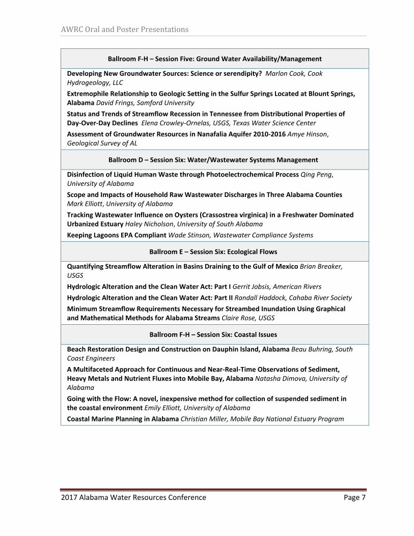
Ballroom F‐H – Session Five: Ground Water Availability/Management
Developing New Groundwater Sources: Science or serendipity? Marlon Cook, Cook Hydrogeology, LLC
Extremophile Relationship to Geologic Setting in the Sulfur Springs Located at Blount Springs, Alabama David Frings, Samford University
Status and Trends of Streamflow Recession in Tennessee from Distributional Properties of Day‐Over‐Day Declines Elena Crowley‐Ornelas, USGS, Texas Water Science Center
Assessment of Groundwater Resources in Nanafalia Aquifer 2010‐2016 Amye Hinson, Geological Survey of AL
Ballroom D – Session Six: Water/Wastewater Systems Management
Disinfection of Liquid Human Waste through Photoelectrochemical Process Qing Peng, University of Alabama
Scope and Impacts of Household Raw Wastewater Discharges in Three Alabama Counties Mark Elliott, University of Alabama
Tracking Wastewater Influence on Oysters (Crassostrea virginica) in a Freshwater Dominated Urbanized Estuary Haley Nicholson, University of South Alabama
Keeping Lagoons EPA Compliant Wade Stinson, Wastewater Compliance Systems
Ballroom E – Session Six: Ecological Flows
Quantifying Streamflow Alteration in Basins Draining to the Gulf of Mexico Brian Breaker, USGS
Hydrologic Alteration and the Clean Water Act: Part I Gerrit Jobsis, American Rivers
Hydrologic Alteration and the Clean Water Act: Part II Randall Haddock, Cahaba River Society
Minimum Streamflow Requirements Necessary for Streambed Inundation Using Graphical and Mathematical Methods for Alabama Streams Claire Rose, USGS
Ballroom F‐H – Session Six: Coastal Issues
Beach Restoration Design and Construction on Dauphin Island, Alabama Beau Buhring, South Coast Engineers
A Multifaceted Approach for Continuous and Near‐Real‐Time Observations of Sediment, Heavy Metals and Nutrient Fluxes into Mobile Bay, Alabama Natasha Dimova, University of Alabama
Going with the Flow: A novel, inexpensive method for collection of suspended sediment in the coastal environment Emily Elliott, University of Alabama
Coastal Marine Planning in Alabama Christian Miller, Mobile Bay National Estuary Program
AWRCOralandPosterPresentations
Page 8 2017 Alabama Water Resources Conference
Abstracts (alphabetical order by author’s last name)
Oral Presentations
Limitstowaterentrepreneurshipandhowtoovercomethem:AcaseanalysisCraigArmstrong,PaulDrnevic,LouisMarino,JeffreyMartin&TheresaWelbourne,UniversityofAlabamaTheSoutheasternUnitedStates’waterwaysandaquiferssupporttensofmillionsoflivesandarecrucialtotheeconomiesofthisregion.Waterwaysandaquiferssupportshipping,industry,agriculture,andrecreationaluses.Intheseways,waterisaneconomicallyvaluablecommodity,yetwaterissomehowtreateddifferentlybecauseitisbothaprivategoodandapublicgood.Apersonwhoconsumesprivategoods,suchasfood,shelter,andclothing,limitstheavailabilityofthatgoodtoothers.Apublicgood,suchasastatepark,isacommoditythateveryoneshares.Waterisauniquecommoditybecauseitbothaprivateandpublicgood.Forexample,youcanenjoytheviewofthelake(apublicgood)thatprovidesdrinkingwatertoyourmunicipalityorhelprunyourfactory(privategood).Asaprivategood,thepriceofwatervariesdependingonwhoisusingit.Thepriceofresidentialuseofwaterservices(drinkingwater,sewage,andstormwatermanagement)foraround7,500gallonsamonthrangesinpricefrom$10to$60.That’s90,000gallonsayearfor$720forresidentialuse.Incontrast,commercially‐intensivewateruserssuchaselectricutilities,mining,andpulpandpaperprocessing,mayuseontheorderoftensofmillionsofgallonsayearforapermitfeeofafewthousandUSdollars.Likepreciousmineralsandoil,waterisacommoditythatisinfactscarcebut,unlikepreciousmineralsandoil,ispricedasacommoditythatisabundant.Thepriceofwaterasaprivategoodisessentiallyfree.Insummary,wateriscrucialtotheeconomicwell‐beingoftheSoutheasternUnitedStates,hasthecharacteristicsofbeingbothapublicorprivategooddependingonhowitisusedandwhoisusingit,andispricedasthoughitwereanabundantresourcewhenitisinfactscarce.Thesefactorsposesubstantialbarrierstoentrepreneurswhowanttocreatenewtechnologiestotreatandconservewater.Whopaysforthetechnologythatimproveswaterusagebyshippingcompaniesorrecreationalboaters?Whataretheincentivesforindustriestoinvestinnewtechnologiesforwaterconservationandtreatmentifwaterissoinexpensiveasaprivategood?Thisstudydrawsfromacaseanalysisofanentrepreneurwhosuccessfullyidentifiedanichemarketforintroducingawaterconservationproductandisnowattemptingtoexpandhisbusiness.Thekeydimensionsofthisanalysisdrawfromresearchframeworksfortheentrepreneurialprocess:howtoidentifypromisingopportunities,howtocreateauniquevalueproposition,howtoidentifyandenternichemarkets,andhowtoexpandintolargermarketsandapplicationsfortheproductorservice.Framingthesequestionswithinthecontextof“waterentrepreneurship”illuminateswhywehaven’tseengrowthincommerciallyviableinnovationsinwatermanagement.Forexample,anentrepreneurorresearchscientistmayhavedevelopedtheconceptforauniquelyvaluableproductorserviceforwatermanagement,butmaynotbeabletoidentifyanaddressable
AWRCOralandPosterPresentations
2017 Alabama Water Resources Conference Page 9
market.Entrepreneurswhodofindaddressablemarketsmaystillfacelimitationstogrowthdependingonthescalabilityoftheproductorserviceintonew,largermarkets.Wefocusonspecifictacticsentrepreneursandscientistscanusetoidentifyandsuccessfullyexploitopportunitiestointroduceuniquelyvaluableproductsorservicesinwatermanagement.Ouranswerstothesequestionsprovideinsightsforentrepreneurs,watermanagementprofessionals,andpolicymakers.RealizingOurSustainabilityPotential:UtilizingUrbanTreesforStormwaterManagementJeremyBailey,GreenBlueUrbanUsingurbantreesasgreeninfrastructureforourcitiesisarguablythemostsustainablestormwatermanagementsolutionavailable.Drainageproblemsarisingfromincreasinglevelsofurbanizationhaveexacerbatedthelimitationsofconventionalsurface‐waterdrainagemeasures.Thepossibilitiestherearetoturnstormwaterrunofffromahindrancetoanopportunityarelimitless.Streettreescanbeessentialcomponentstothemanagementofstormwaterinurbanareas.Liketheirwoodlandforestequivalents,urbantreesdirectprecipitationintothegroundthroughtrunkflowandabsorbrainfallthroughtheirroots–makingthemaninvaluablesustainabilityassetintheurbanenvironment.Traditionaldrainagesystemsforsurfacewaterrunoffhavebeendesignedtotransferrainwaterfromwhereithasfallentoeitherasoak‐awayorawatercourseasrapidlyaspossible.Thismethodincreasestherisksofflooding,environmentaldamage,andurbandiffusepollution;sincerunoffwaterusuallycarriescontaminantsincludingoils,heavymetals,pesticides,fertilizers,chemicalsandotherurbanmatter.Specificallydesignedurbantreepitsystemscaneffectivelyandsustainablymitigatethesechallengesandsignificantlyreducethevelocityandflowrateofsurfacewaterrunoffinurbanareas,contributingtowardsmeetingtherequireddischargerates,whilefilteringoutharmfulpollutantsandcontaminantscarriedinsurfacewater.ThispresentationusesGreenBlueUrban’s25yearsoffieldexperience,inconjunctionwithworld‐renownedresearcherssuchastheUniversityofAbertayDundeeandE2DesignLabs,toexaminetheopportunitiesavailableforintegratingstormwatermanagementintourbantreeplantingfortrulysustainableurbanlandscapes.
AWRCOralandPosterPresentations
Page 10 2017 Alabama Water Resources Conference
Aftermath:WaterPolicyImplicationsofFloridav.GeorgiaBennettBearden,WilliamAndreen,&NathanielBroadhurst,TheUniversityofAlabama.In2013,FloridafiledamotionintheU.S.SupremeCourtforleavetofileacomplaintseekinganequitableapportionmentoftheACFbasin.Floridav.Georgia,No.142Orig.(filedSept.25,2013).FloridasoughttocapGeorgia’soveralldepletivewateruses.Alabamawasnotnamedinthelawsuit.TheCourtgrantedFlorida’smotioninNovember2014andappointedRalphLancaster,aPortland,Maineattorney,asSpecialMaster.Inearly2015,GeorgiamovedtodismissthecaseforfailuretojointheUnitedStatesasaparty.GeorgiaarguedthattheUnitedStateshadtobejoinedasapartybecauseFloridacouldnotbegrantedcompletereliefunlesstheUnitedStates,astheoperatorofanumberofdamsintheACFbasin,wasboundbythefinaljudgment.TheSpecialMasterdeniedGeorgia’smotion.TheSpecialMastercontinuallyurgedthepartiestosettlethecase,butnegotiationswereprotracted.Accordingly,hesetatrialdateinthecaseforOctober31,2016.Afterfiveweeksoftrial,concludingonDecember1,2016,theSpecialMasteragainimploredbothsidestonegotiateasettlement.CaseManagementOrderNo.22,January3,2017,Doc.634,specificallyrequiredFloridaandGeorgiatomeetandconferaboutsettlementandtoconsider,interalia,asolutionthatmightinvolvepossibleimportationofwater,viaaninterbasintransfer(IBT)fromoutsidetheACFBasin.Thenegotiations,however,provedfruitless.OnFebruary14,2017Georgiaclaimedamajorvictoryinthislong‐runninglegaldisputewhentheSpecialMasterissuedhis70‐pagereporttotheUnitedStatesSupremeCourt,whichconcludedthatFloridahadfailedtoprovethatnewlimitsonGeorgia’swaterconsumptionwouldprovideFloridawiththereliefthatithadsought.TheReportoftheSpecialMasterinFloridav.GeorgiaraisessomeinterestingwaterpolicyissuesforAlabama.IfAlabamaeverendsupinanoriginalactionagainstGeorgiaoranotherstateoverwaterissues,areviewofSupremeCourtprecedentsuggeststhathavinggooddataonwateravailability,use(withdrawals),andfuturedemand,isimportanttowinningthosecases(Coloradov.NewMexico,467U.S310(1984)).AnothermoreindirecttakeawayfromtheReportisthedangerposedbyunrestrainedagriculturalirrigation.InGeorgia’swaterwithdrawalpermittingsystem,farmersweremadelargelyexemptfromtheregulationsimposedonotherconsumptiveusers,andthisclearlyhashadasignificantimpactonflowsintheFlintRiver—especiallyduringdroughtconditions.Further,analogieshavebeendrawnbetweenthesensitiveMobileBayecosystemsandthoseinApalachicolaBay,aswellassimilaritiesinthetwoareas’seafoodindustries.Thus,itisnotoutofthequestiontobeginplanningnowinordertoavoidasimilarfateforMobileBaythathasdevastatedApalachicola’saquaticlifeandeconomicbase.TheaftermathofFloridav.GeorgiafurtherhighlightstheneedforAlabamatodevelopacomprehensivestatewatermanagementframework.
AWRCOralandPosterPresentations
2017 Alabama Water Resources Conference Page 11
EvaluatingBaselineWatershedConditionsandIdentifyingRestorationOpportunitiesUsingMobileDataCollectionSoftwareDavidBell,CH2MSinceSeptember2014,TheNatureConservancy(TNC)‐MississippiChapterhasimplementedaninnovativeconservationprogramknownastheCoastalStreamsandHabitatInitiative.WorkinginpartnershipwiththeMississippiDepartmentofEnvironmentalQuality(MDEQ)andthePascagoulaRiverAudubonCenter,TNCdevelopedanapproachtoaddressimpairedwatershedconditionsfromincreasedurbanization,reducedriparianbuffers,streambankerosionandsedimentationandwaterqualityimpairments.TNC’seffortsincludecoordinatingwithlocalstakeholders,developmentofConservationActionPlans(CAPs),engaginginstreamstewardship,collectingbaselinemonitoringdataanddevelopingdetaileddesignsforfuturewatershedimprovementprojectswithinninesmallcoastalstreamsinallthreecoastalcounties(Hancock,Harrison,andJackson).TheworkwasfundedbytheNationalFishandWildlifeFoundation’sGulfEnvironmentalBenefitFund,utilizingfundsfromtheDeepwaterHorizonoilspillof2010.In2016,aspartofthebaselinemonitoringprogram,sixcoastalwatershedswereidentifiedforanalysisofexistingconditionsaswellasthepotentialtodevelopfuturestreamrestorationorwatershedimprovementprojects.Thosewatershedsinclude,WattsBayou,MagnoliaBayou,CoffeeCreek,OysterBayou,RhodesBayouandChicotBayou.Toaccomplishtheprojectgoals,CH2MwascontractedtoconductdesktopanalysisusingArcGISsoftwareaswellasperformmobilefielddatacollectionusingthecloud‐basedArcGISCollectorapplication.OveraperiodofthreeweeksinAugustthefieldteamsassessedover40milesofstreambankandmarshedge,evaluatingriparianbuffers,erosion,presenceofinvasivespecies,conditionofstormwaterinfrastructure,sedimentdeposition,aswellascollectinginsituwaterqualitymeasurements.ThispresentationwillsummarizetheresultsofthewatershedassessmentaswelldiscussthemethodsandnumerousadvantagesofusingGISsoftwareinconjunctionwithacloud‐basedmobiledatacollectionapplicationduringfieldwork.
AWRCOralandPosterPresentations
Page 12 2017 Alabama Water Resources Conference
ALOysterShellRecyclingProgram:ConnectingpeopletotheirCoastMarkBerte,AlabamaCoastalFoundationTheAlabamaCoastalFoundation,whichwillcelebrateits25thAnniversarynextyear,improvesandprotectsAlabama'scoastalenvironmentthroughcooperation,educationandparticipation.Lastyear,ACFestablishedtheAlabamaOysterShellRecyclingProgramfromagrantfromtheNationalFishandWildlifeFoundation'sGulfCoastConservationGrantsProgram.ParticipantsinthissessionwilllearnaboutthegenesisoftheAOSRProgram,theprocessusedtoeducaterestaurants,howtheAOSRimplementationplanwasdevelopedandexecuted,aswellasthecurrentstatusofcollection/stewardshipefforts.[PRESENTATIONREVIEWERNOTE:AsofJune19,theProgramisfivemonthsaheadofschedulewithover2.7millionshellscollectedsincetheprogramstartedwhichtranslatestoabout6.8acresofreefortheweightofover56elephants.]Simplyput,theAOSRProgramcollectsoystershellsfromlocalrestaurantsthatusetoconsiderthemastrash.Instead,thatimportantnaturalresourceiscollectedthreetimesaweekfromparticipatingrestaurantsandtakentoasitewheretheycancureforsixmonths.ThoseshellsarethenputbackintoAlabamawaterwheretheycanhelpnewoystersgrowbecausethoseshellsarethepreferredhabitatofoysterbabies(larvae)tosettleonasjuveniles(spat)toformnewreefs.Inadditiontofoodvalueandbeingimportanttoourlocaleconomy,oystersprovidemanyotherecosystemservices,suchas:‐Improvingwaterquality:Anadultoystercanfilter12gallonsofwaterperday.‐Providinghabitat:Oysterreefsprovidehabitatforothershellfish,fish,shrimp,crabs,birdsandotheranimals.‐Limitingerosion:Oysterreefsarenaturalbreakwatersthatprotectshorelines.ThisAlabamaOysterShellRecyclingProgramisbeingledbytheAlabamaCoastalFoundationwhichusesaninclusiveenvironmentalstewardshipapproach.Toensurethesuccessofthisproject,ACFhascreatedanAdvisoryCommitteeofrestaurantowners,managersandchefsinadditiontorepresentativesfromtheAlabamaDepartmentofConservationandNaturalResources,TheNatureConservancy,Mississippi‐AlabamaSeaGrantConsortiumandtheMobileBayOysterGardeningProgram.TheAOSRProgramisembeddedintoallofACF'seducationandstewardshipprogramsandthepositiveimpactofthisnewprogramistakingplacenowandwillcontinuetogrowinthefuture.
AWRCOralandPosterPresentations
2017 Alabama Water Resources Conference Page 13
QuantifyingstreamflowalterationinbasinsdrainingtotheGulfofMexicoBrianBreaker,U.S.GeologicalSurveyAlterationofthehydrologicregimeoftributariestotheGulfofMexicohasbeenidentifiedasacrucialcomponentaffectingthehealthofestuariesintheGulfofMexico.Hydrologicalterationcanoccurasaresultofseveralanthropogenicactivitiesincludingimpoundment,surface‐waterwithdrawalandreturn,changestothelandscapeofwatersheds(e.g.urbanizationandagriculturalactivities),channelization,anddiversion.Theseactivitiescanaffectcharacteristicsoftheflowregimeofastreamincludingthemagnitude,frequency,duration,timing,andrateofchangeofstreamflow(OldenandPoff,2003).In2017,theU.S.GeologicalSurveybeganananalysisofhydrologicalterationofstreamsflowingtotheGulfofMexicofromthefiveGulfStates(Alabama,Florida,Louisiana,Mississippi,andTexas)toquantifytheextentofhydrologicalterationandcreateatooltoassistwaterresourcemanagersinmeasuringthepotentialimpactstothehealthofestuariesintheGulfofMexicowhenevaluatingdifferentsurface‐waterusescenarios.Hydrologicalterationwillbequantifiedthroughoutthestudyareausingmachine‐learningalgorithms(i.e.models).Thesemodelswilluseexistingstreamflowrecordsforabout1400streamgageslocatedincurrent(altered)andreference(unaltered)basins,andwillprovidethetoolsnecessarytoestimateanalteredandunalteredvalueforagivenstreamflowcharacteristicatgagedandungagedlocations.Whencomplete,thisanalysiswillsupportrestorationeffortsbyidentifyingandprioritizingthemostandleastalteredstreamsthroughouttheregion.Spatialpatternsandtrendsinstreamflowcharacteristicswillberelatedtoestuaryhealth.Informationfromthemodelswillalsobeusedtoconductnetwork‐optimizationanalysistoidentifyprioritylocationsfornewstreamgageinstallation.Inaddition,anonline‐mappingtoolwillbecreatedtoprovideinformationonspatialandtemporalpatternsofhydrologicalteration.OldenandPoff,2003,Redundancyandthechoiceofhydrologicindicesforcharacterizingstreamflowregimes,RiverRes.Applic.19:101‐121
AWRCOralandPosterPresentations
Page 14 2017 Alabama Water Resources Conference
BeachRestorationDesignandConstructiononDauphinIsland,AlabamaBeauBuhring,SouthCoastEngineersThebeachesofDauphinIslandhavebeenrapidlyerodingforyears,someasmuchas700feetinrecentdecades,threateningavaluablemaritimeforestandfreshwaterlakehabitatinanAudubonBirdSanctuary.TheEastEndBeachandBarrierIslandRestorationProjectwasconstructedbetweenOctober2015andMarch2016toprotectandpreservethishabitat,restoreerodingbeachesanddunes,providestormprotectiontootheruplandresources,andenhanceanexistingrecreationalbeach.Itwasthefirstmajorengineeredbeachrestorationprojectintheisland'shistory.The0.92milelongprojectinvolvedthedredgingandplacementofabout320,000cubicyardsofgoodqualitysandonthesoutheasternDauphinIslandbeaches.Sandfortherestorationproject,sourcedfromaborrowsite4.5milesoffshore,wasidentifiedafteranexhaustivesandsearchandanalyzedforcompatibilitywiththenativebeach.Constructionincludedtherehabilitationofeightrockgroinsintothreenew,nearshore,segmentedbreakwaterstohelpretainsand.Theprojectincreasedthewidthoftherestoredbeachesbyabout200feetonaverageandpermanentlyaddedsandtoDauphinIsland’sEastEndbeaches.ThisuniquerestorationprojectwasnamedoneofAmerica’sBestRestoredBeachesin2017bytheAmericanShoreandBeachPreservationAssociation(ASBPA).Thispresentationwilldescribethecoastalengineeringdesignandanalysisthatmadethisprojectasuccess,includingnavigationofachallengingpermittingprocess,theactualconstructionphase,andnewlyavailablemonitoringdataoneyearafterconstruction.HowyoucanbeapartofAlabamaDamSafetyWadeBurcham,IntegratedScience&EngineeringTherearemanyagingdamsacrossthecountry,andAlabamahasitsfairshare.Someofthesedamshavelongsincebeenforgotten‐thisdespitetheirpotentialtocauseseveredamage,andinmanycases,lossoflife.AsAlabamaWaterResourceProfessionals,wearesometimesbydefaulttaskedwithbeingthevoiceforthepublicregardingDamSafety.Thispresentationaimstoequipparticipantswithhelpfulinformationforcommunicatingrisktothosewhomayhavealackofawareness,ormayevenbeindifferenttothesubject.Informationaboutpastdamfailures,pastattemptsatastatedamsafetyprogram,aswellascurrenteffortsthatareunderwaywillbepresented.ComelearnaboutnewresourcesonhowyoucanbefurtherequippedinregardstoDamSafety,andhelpbuildavenuestoraisepublicawarenessofthiscriticaltopic.
AWRCOralandPosterPresentations
2017 Alabama Water Resources Conference Page 15
IncreasingFloodRiskAwarenessandResiliencethroughtheAlabamaFloodplainManagementProgramClayCampbell,AmecFosterWheeler&WandaErvin,ADECAOfficeofWaterResourcesOverthelast15plusyears,theAlabamaOfficeofWaterResources(OWR)hasupdatedtheFederalEmergencyManagementAgency(FEMA)FloodInsuranceRateMaps(FIRM)forall67countiesinAlabama.AsoneofFEMA’sCooperatingTechnicalPartners(CTP),OWRcontinuestoupdatefloodmapsunderFEMA’sRiskMapping,Assessment,andPlanning(RiskMAP)program.Inrecentyears,morefocushasbeenplacedonstrengtheningcommunityengagement,betteringcommunication,andimprovingtheunderstandingoffloodriskamonglocalstakeholders.TheOWRapproachistotailorthefederalguidelinestoenhancestateandlocalfloodriskmanagementandmitigationinitiatives.OWRhasdevelopedaseriesoftoolsandtrainingsthatgobeyonddiscussingtraditionalfloodplainmapstohelpcommunitiesbetterrecognizetheirfloodrisksandeducatelocalstakeholdersonhowtobestinvestinsustainablemitigationactions.Toassistwithcommunityengagementandoutreach,OWRhasdevelopedawebsitethatprovidesanaudienceofcommunityofficials,propertyowners,andotherstakeholderstheabilitytoviewanddownloadpreliminaryandeffectivefloodinformation.Thewebsitecurrentlycontainsregulatoryandnon‐regulatoryproductsdevelopedduringeachRiskMAPproject,includingFIRMs,ChangesSinceLastFIRM(CSLF),depthandprobabilitygrids,andpotentialflooddamages.Futureplansforthewebsiteincludetheoptiontodownloadnewlyeffectivehydraulicmodels.Thiswebsiteprovidesamoreefficientmeansofreviewingpreliminarydataandretrievingeffectivedataaswellasdeterminingareasforpotentialmitigationactions.OWRhascompletedseveralwatershedRiskMAPprojectsandhavemanyothersunderway.ForeachRiskMAPproject,datahasbeenorwillbemadeavailableonthenewwebsite.However,OWRalsoprovidesothertoolsandtrainingonasuiteofrisk‐basedproductsthatcanbeutilizedbycommunitiestomitigatefloodriskandincreasefloodriskawarenessandresilience.Thesetrainingsincludethewell‐receivedRiskMAPToolsTraining,anin‐persontutorialforlocalstakeholdersontheRiskMAPdatabase,aswellasotherproducts,thatalsoaimtoassisttheminidentifyingfloodriskchangeandareasofmitigationinterestwithintheircommunity.OWRalsohostsaYouTubechannelthatcontainspre‐recordedtutorialsonmanyoftheRiskMAPproducts.OWRaimstoaddmoretutorialsinthefuture.EachofthesetrainingsandtutorialsaremeanttoincreasetheabilityofaCommunityOfficialtocommunicatefloodriskandencourageactionstoreducerisktolifeandproperty.ThegoalofthispresentationistodemonstrateOWR’scommitmenttotakingactiontoreducefloodriskinAlabamabyprovidingcommunityofficialsandotherstakeholderswithmultipleresourcesbeyondtraditionalfloodriskproductstohelpthemincreasefloodriskawarenessandresilienceatthelocallevel.
AWRCOralandPosterPresentations
Page 16 2017 Alabama Water Resources Conference
WeeksBayWatershedManagementPlan‐OverviewofWatershedConditionsandWaterQualityJohnCarlton,DoubleJFarms;MikeEubanks&EmeryBaya,ThompsonEngineeringOneofthetasksinpreparationoftheWeeksBayWatershedManagementPlan(WBWMP)wastoassesswatershedconditions,withparticularemphasisonwaterquality.Section3.0oftheplanprovidesadetailedreviewofthewaterqualityprogramsandwaterqualitystandardsapplicableintheWeeksBaywatershed,andpresentsavailablewaterqualitydata.Becauseofthesizeofthewatershedandbudgetaryconstraints,collectionofnewwaterqualitydatawasnotpartoftheproject.Over40scientificreportsorsourcesofdatarelatingtowaterqualitywereidentified,themorecomprehensiveonesbeingusedtoprovideanassessmentofwatershedconditions.Additionally,theSoilandWaterAssessmentTool(SWAT)modelwasdevelopedandcalibratedforbothFishandMagnoliaRiversandutilizedtoestimatecurrentandfuturesedimentandnutrientloadingsfromapproximately235subwatershedsandover2,000HydrologicalResponseUnits.(Dr.KalinwithAuburnUniversityperformedthistaskandwillpresentitseparately.)TheentireWeeksBaywatershediscomprisedoffour12‐digitHydrologicUnitCodes(HUCs)draininganareaapproximately27mileslongand12mileswide,orroughly130,000acres.EachofthefourHUC‐12watershedsarediscussedseparatelyintheWBWMP.ThelowerreachesareintheGulfCoastFlatwoodsecoregionandtheupperriverineportionsareintheSouthernPinePlainecoregionwithagriculturallanduses,includingsilviculture,predominatingthelandscape.Theclimateishumidsubtropicalwithabundantrainfall(~67in/yr)andtheareaisfrequentlyinfluencedbytropicalcyclones.AssessingwaterqualitywascomplicatedbybothtoolittledataandtoomuchdataandthedatasourcesarediscussedinthePlan.Generally,thebayandmainstemofeachriverappeartobemeetingtheADEMwaterqualitystandardsmostofthetime,withwaterqualityinFishRiverbeingratedbyAlabamaDepartmentofEnvironmentalManagement(ADEM)asGOODandMagnoliaRiverbeingratedasFAIRasrecentlyas2011.However,thereare4segmentslistedonthe2016ADEM303(d)listasimpairedduetofishconsumptionadvisoriesrelatedtomercury(FishRiver,CowpenCreek,PolecatCreekandMagnoliaRiver)andonesegmentlistedasimpairedduetoorganicenrichment(BakerBranch).Thesourceofmercuryisthoughttobeatmosphericdepositionandthesourceoforganicenrichmentisthoughttobecattlegrazingoperations.Itisalsoevidentthatpathogenlevelsfrequentlydonotconformtothewaterqualitystandards,particularlyfollowingrainfalleventsandtheADEMpathogenTotalMaximumDailyLoad(TMDL)callsfora68%loadreductionfromnon‐pointsourcesintheFishRiverwatershed.Todate,effortstoidentifythesourceofpathogensbytype(human,wildlife,orlivestock)andlocationhavebeeninconclusive.Waterqualityissuesrelatedtopathogens,dissolvedoxygen,sediment,turbidityandnutrientloading(nitrogenandphosphorus)arealsoevidentinthedatareviewedforanumberoftributariesthroughouttheWatershed.Althoughoccasionalwaterqualityissueswerereportedformostalltributariesthathavebeensampled,themostprominentwaterqualityimpactshavebeendocumentedinCornBranch,PensacolaBranch,BakerBranch,CowpenCreek,WaterholeBranchandTurkeyBranch(lower)inFishRiverwatershed,andWeeks
AWRCOralandPosterPresentations
2017 Alabama Water Resources Conference Page 17
CreekandanunnamedtributaryintheMagnoliaRiverwatershed.Theimpactsappeartobeassociatedwithbothincreasingurbandevelopmentaroundtheperimeterofthewatershedandpervasivehistoricalandon‐goingagriculturalactivities.AlthoughclassifiedbyADEMasanOutstandingNationalResourceWater,WeeksBayproperisconsideredbyallaccountstobeeutrophic,withhighnutrientloadsfromFishandMagnoliaRiversfrequentlytriggeringincreasedalgalactivityandassociatedlowdissolvedoxygenlevels.BecausetheBayisshallow,theselowdissolvedoxygenandstratificationeventsareusuallyshort‐lived,beingovercomebywindaction.UsingGISandStoryMapsforWatershedManagementandMonitoringJohnCartwright,MississippiStateUniversity
AcollaborativeeffortatMississippiStateUniversityhasproducedtheCatalpaCreekWatershedRestorationandProtectionProject.Theeffortinvolvesover30facultyandadministratorsfromMSUand10staffmembersfromfouragencies.DuringthefirsttwoyearsoftheprojectacomprehensiveWatershedResourceManagementPlanandanImplementationPlanforPhase1oftheprojectweredeveloped.AninitialeffortofPhase1involvescharacterizingthewatershed.Multipleresearchershavebeeninvolvedingatheringexistingdata,collectingnewdata,andformulatinghydrologicandhydraulicmodelsforthewatershed.Asameansoftransferringthisinformationbetweencollaborators,stakeholders,andothersassociatedwiththeeffortwehaveimplementedEsri’sStoryMaps.StoryMaps(builtuponArcGISOnlineresources)areinteractive,web‐basedapplicationsthatcombinegeographicinformationwithtextandmultimediacontent.UtilizationofStoryMapsimprovesdataaccessibilityacrossmultipleplatforms,improvingdatamanagementandinformationtransfer.BybringingStoryMapsintothisprojectwearebuildingafoundationthatwillprovideaseamlesstransitionfromresearchtoeducationandoutreachasthisprojectcontinuestodevelopacrossmultiplephases.
HighDefinitionStreamSurveyoftheDuckRiver,covering120milesin8dayswithonly2people.BrettConnell,TruttaEnvironmentalSolutionsTheHighDefinitionStreamSurveyoftheDuckRiverisourlongestsurveytodateandcovered120continuousmilesin8dayswithonly2people.TheTennesseeDept.ofEnvironmentandConservation,TennesseeValleyAuthority,ColumbiaPowerandWater,andtheSouthCentralTennesseeDevelopmentDistricthaveallfundeddifferentportionsofthesurveyandisanexampleofhowpartnershipscanlowerthecostofsurveysandincreasestheamountofdataforeveryoneinvolved.TheHighDefinitionStreamSurvey(HDSS)approachwascreatedtorapidlygathercontinuousgeo‐referenceddatainasinglepassforabroadrangeofstreamandstreambankconditionsbyintegratingGPS,video,depth,waterqualityandothersensors.ResultsfromHDSSdatacanbeusedtodeterminetheextentanddistributionofinstreamhabitat,locateareasthatcontributetopoorstreamconditions,definethegeomorphicconditionfor
AWRCOralandPosterPresentations
Page 18 2017 Alabama Water Resources Conference
thestream,identifyinfrastructureimpacts,documentrestorationresultsandprovideapowerful“virtualtour”experience.DevelopingNewGroundwaterSources:ScienceorSerendipity?MarlonCook,CookHydrogeology,LLCTherearelotsofsimilaritiesbetweenexploringforoilandgasandexploringforgroundwater.Inbothcasesthedesiredfluidexistsbecauseofacombinationofvariousnaturalprocesses,includingclimate,geography,geology,andchemistry.Discoveryofbothfluidsinthesubsurfacehasalonghistoryinvolvingvaryingdegreesofscientificknowledgeandserendipity.Itisoftensaidthattheexplorationistwilltakeluckoverscienceanytime.However,aseconomicquantitiesofthesevaluableresourcesbecomemorescarce,goodscienceplaysaneverincreasingrole.ThispapersummarizesfourexamplesinvolvingexplorationforpublicgroundwatersuppliesinfourdistincthydrogeologicalprovincesofAlabama.StatusandTrendsofStreamflowRecessioninTennesseefromDistributionalPropertiesofDay‐Over‐DayDeclinesElenaCrowley‐Ornelas,RodneyKnight,&WilliamAsquithU.S.GeologicalSurvey,Statisticalpropertiesofstreamflowrecessionprovideevidenceofhydrologicprocessessuchasgroundwaterandsurface‐waterinteractions.Bingham(1982,1986)soughtregionaldefinitionofgeneralizedconnectivitybetweensurface‐waterandgroundwaterbycalculatingapersistentstreamflowrecessionslopeduringwinterlowflowsandthenrelatingtherecessionslopestosurficialgeology.TherecessionslopevalueisoftenreferredtoastheBingham"geologicfactor”orG‐factor.TherecessionslopedeterminedbyBingham’sprocesswassomewhatsubjectivebecauseitwashanddrawnbasedonthevisualinspectionofthestreamhydrograph.TheG‐factorwasderivedthroughahands‐ongraphicalmethodforselectedpeakflowsovera20‐yeartimeperiodfromU.S.GeologicalSurvey(USGS)streamgagesinTennesseeandAlabama.Astreamflowrecessioncurve,plottedonsemi‐loggraphpaper,wascreatedbystartingatpeakdischargeafteraprecipitationeventuntilthelinenearedasymptoticwiththex‐axis.Thenumberofdays(x‐axis)requiredforstreamflowtodecreaseonelogcycle(y‐axis)wastheindexofstreamflowrecessionforeachstation,ortheG‐Factorexpressedindaysperlogcycledeclineinflow.BoundariesforG‐factorsweredeterminedusingstreamflowhydrographsandsurficialgeology.Basin‐weightedvaluesoftheG‐Factorhavebeenshownstatisticallysignificantinstatisticalregionalizationofvariousaspectsoftheflowregime(Bingham,1982,1986;Knightandothers,2012)inAlabamaandTennessee.AlthoughG‐factorvalueshavebeenuseful,thesubjectivityandtime‐consumingmanualmethodoftheapproachhasmadeitproblematictocalculateG‐factorsfornewerrecordsanddifferentregions.TheUSGShasdevelopedanautomatedprocessthatcalculatesG‐factorsandhasappliedthismethodtomorethan300streamgagesandmorethan4milliondaysofstreamflowatstreamsinorborderingTennessee.ResultsfromtheautomatedprocesswillbecomparedtotheoriginalG‐Factorestimatestoassesswhetherthisnewmethodiscapturingthesamehydrologic
AWRCOralandPosterPresentations
2017 Alabama Water Resources Conference Page 19
processinformation.Additionally,graphicsandmapsdepictingstatusandtrendsinstreamflowandassociationswithBingham'soriginalwork,willprovideadditionalspatialanalysisofpertinenthydrogeologiccharacteristicsinthestudyarea.DevelopinganautomatedprocessusingexistingdatatocalculatetheGfactorwillmakeitpossibletoestimatethefactorforlargerareasaswellasfordiscretetimeperiods.Thisnewapproach,ifsuccessful,willprovideatooltoevaluatetheextentofconnectivitybetweensurface‐waterandgroundwaterinabasin;theinfluenceofgroundwaterwithdrawalsonbaseflow;andcouldbeanearlyindicatorofpotentialdroughteffects.Bingham,RH.1986.“RegionalizationofLow‐FlowCharacteristicsofTennesseeStreams.”Water‐ResourcesInvestigationsReport.http://pubs.er.usgs.gov/publication/wri854191.Bingham,RoyH.1982.“Low‐FlowCharacteristicsofAlabamaStreams.”WaterSupplyPaper.http://pubs.er.usgs.gov/publication/wsp2083.Knight,RodneyR.,W.ScottGain,andWilliamJ.Wolfe.2012.“ModellingEcologicalFlowRegime:AnExamplefromtheTennesseeandCumberlandRiverBasins.”Ecohydrology5(5):613–27.doi:10.1002/eco.246.Isthepresentakeytothepastoristhepastakeytothepresent:alookintothepaleofloodrecordoftheTennesseeRiverinAlabamaLisaDavis,ChristopherStewart&NatashaDimova,UniversityofAlabama;GaryStinchcomb&RachelLombardi,MurrayStateUniversity;&StevenForman,BaylorUniversity,Despitesignificantadvancesinmeteorologicalandhydrologicalforecastinginthelast50years,catastrophicfloodsconstituteoneofthemostgloballypersistentnaturalhazards.Theyear1931marksthelasttimetheU.S.didnotexperienceasingleflood‐relatedfatality.Atleast10flood‐relateddeathsoccurperyearintheU.S.Limitationsintheinstrumentedflowrecordsofriverspartlycontributestothisproblem.Instrumenteddischargerecordsrarelyspanmorethan100years,meaningtheyaretooshorttocapturelargefloods,whichtendtooccurlessfrequently.Instrumentedflowrecordsonlyspanthetimeofhumanoccupation,whichmakesunderstandingvariabilityoffloodsrelatedtoclimatevariabilityusingtheserecordsmorechallenging.Becauseoftheselimitations,waterresearchersandmanagersareincreasinglyturningtonaturalarchivesoffloodfrequencyandmagnitudeinformation,suchasdendrochronologyandsedimentarydepositsfromfloodsthatarepreservedinthelandscape,inadditiontotheinstrumentedrecord.Paleofloodhydrologyfocusesoncollectingandanalyzingphysicalevidenceofpastfloodsthatoccurredbeforetheinstrumentedrecordforfloodriskassessmentandunderstandingenvironmentalchange.FederalagenciesworkinginthesouthwesternU.S.,includingtheU.S.GeologicalSurveyandU.S.BureauofReclamation,haveusedpaleofloodhydrologytoassessfloodriskfordams,powerplants,andpublicspacesfordecades.DespiteitslongstandingandwidespreadapplicationinotherregionsoftheU.S.,paleofloodanalysesarerarelyusedtoinformfloodfrequencyandriskassessmentinriversoftheeasternU.S.Newfederalguidelines(USGSBulletin17C:GuidelinesforDeterminingFloodFlowFrequency)recommendincorporatingpaleoflooddatainfloodfrequencyestimations,makingincreasedapplicationandunderstandingofpaleofloodanalyses
AWRCOralandPosterPresentations
Page 20 2017 Alabama Water Resources Conference
imperative.OurpresentationwilldemonstratesomeofthebasicprinciplesofpaleohydrologicresearchandpresentpreliminaryfindingsofapaleofloodrecordwearedevelopingforthemiddleTennesseeRiver(inthevicinityofGuntersvilleandHuntsville,AL),aspartofabroaderefforttodeveloppaleoflooddataforfloodfrequencyanalysesfortheTennesseeRiver.4‐HALWaterWatch:IncreasingEnvironmentalLiteracyandWatershedStewardshipthroughYouth‐FocusedCitizenScienceMonaDominguez,4‐HALWaterWatch&SergioRuizCórdova,AWWThepurposeofthispresentationistointroducetheaudiencetotheYouth‐FocusedCitizenScienceProgram,4‐HAlabamaWaterWatch(4‐HAWW),todiscussoutcomesofarecentlycompleted4‐HAWWProjectfundedbytheUSEPA,todemonstratehow4‐HAWWcanbeincorporatedintowatershedstewardshipefforts,andtoexplainhowinterestedyouthandeducatorscangetinvolvedwithorsupporttheprogram.The4‐HAWWProgramwasdevelopedthroughapartnershipofAlabamaWaterWatch(AWW)andAlabama4‐H.In2015,4‐HAWWreceivedfundingfromtheEPAforatwo‐yearprojectwiththegoalofbuildingcapacitywithintheAlabamaCooperativeExtensionSystem4‐HAlabamaWaterWatchProgramtoprovideeducatorsincludingteachers,volunteers,and4‐Hagentswiththetraining,materials,andsupportneededtoincreaseenvironmentalliteracyforyouth(ages9–18)inAlabama.Theprojectcontributestothelong‐termgoalof4‐HAWWwhichtoengageyouthinwatershedstewardshipintheirlocalcommunitiesandultimatelymakeinformedandresponsibledecisionsabouttheenvironment.Thethreemajorprojectobjectivesimplementedtoachievethisgoalwere:1)Completedevelopmentofa4‐HAWWcurriculumthatwillguideeducatorsastheyprovidestudentswithhands‐oncitizenscienceexperiencesfocusedonconductingwaterchemistryanalysisandbiomonitoringintheirlocalwaterbodies,includingthedevelopmentofanonlinewatermonitoringCitizenScienceDataSimulation.2)Trainapproximately100educatorstoutilizethecurriculumatworkshopsfacilitatedinpartnershipwithenvironmentalcentersthroughoutthestate,and3)Supportparticipatingeducatorsastheyimplementthecurriculumbyhelpingthemaccessmonitoringmaterials,managingthedatabasethatstoreswaterdata,andmanagingthewebsitewherethedatasimulationandwaterdataisaccessed.Asaresultoftheproject,anewnine‐module300‐pagecurriculumExploringOurLivingStreams:AnIntroductiontoWatershedStewardship,StreamBiomonitoringandWaterChemistryMonitoring(EOLS)wasdevelopedandprinted,over100educatorsweretrainedandcertifiedtoimplementEOLSwithstudents,andstreambiomonitoringsuppliesandwaterchemistrymonitoringkitsweredistributedto4‐HCountyOfficesforcheck‐outbyparticipatingeducatorsandstudents.Duringtheprojectperiod,around3,000studentshavebeenreachedby4‐HAWW.StudentsexposedtoEOLShaveincreasedknowledgeandunderstandingofthewaterenvironment,pollution,andwatershedstewardship.Studentswhobecomemonitorsgainskillsrelatedtotestingwateranddataentry,analysis,andinterpretation.4‐HAWWisbeingsuccessfullyimplementedinavarietysettingsthatincludetheformalclassroom,specialtyclubsduringorafterschool,andevenchurchgroups.WatershedManagementPlansaddressingimpaired
AWRCOralandPosterPresentations
2017 Alabama Water Resources Conference Page 21
waterbodies(fundedbySection319Grants),haveincorporated4‐HAWWasaneducationalactivitythatcanalsoproducevaluablewaterdatausedtoevaluateprojectprogress.Participantswilllearnhowtheycanbecomepartoftheprogramandincorporate4‐HAWWintotheirwatershedstewardshipprojects.ScopeandimpactsofhouseholdrawwastewaterdischargesinthreeAlabamacountiesMarkElliott,ParnabDas,ErdoganAytekin,YuehanLu,UniversityofAlabama;KevinWhite,UniversityofSouthAlabama;&RobertJones,DowntoEarth,Inc,A2005studyofBibbCounty,Alabama,showedthat15%ofhouseholdsnotconnectedtosewerdirectlydischargedrawsewageand35%hadsepticsystemsthatwerefailing(WhiteandJones,2006).DiscoveryofthisreportfromBibbCountyandconversationswithlocalstakeholdersledourteamtostudythescopeoftheprobleminnearbyAlabamacounties.Therefore,twonearbycounties,HaleandWilcoxcounties,withhighratesofpoverty(26.6%and39.2%,respectively)andlargelyimpermeableclaysoilswerechosen.Thestudyusestwomainmethods(1)site‐by‐siteinspectionsofarandomsampleofunseweredruralcommunitiesand(2)watersampleanalysisfromimpactedstreams.Siteinspectionandwatersamplingdataindicateveryhighratesofstraightpipedischargeandsubstantialimpactsofwaterqualityinlocalstreamsandtributaries.InWilcoxCounty,approximately60%ofsurveyedunseweredhouseholdshadavisiblestraightpipesurfacedischargeofrawwastewaterandonly7%ofhouseholdshadapermittedonsitewastewatertreatmentsystem.Fortheremaining33%,inspectioncouldnotdeterminewhetherthedischargewasaboveorbelowgroundbuttherewasnoevidenceofasepticsystemdrainfieldoramoundsystem(oftenthisindicatesthatastraightpipeisburiedanddischargestoahidden,overgrownarea).Thisrateofstraightpipedischargewouldconservativelyamounttoover500,000gallonsperdayofrawsewagedischargedtothegroundinWilcoxCountyalone.InHaleCounty,siteinspectionsrevealedfewerhouseholdswithvisiblestraightpipes(6%)andmorewithpermittedsystems(35%).However,59%ofunseweredhouseholdshadanunknowndischargeandwereunpermitted;manyofthesewerelikelyburiedstraightpipeswithahiddensurfacedischarge.WatersampleanalysisonBigPrairieCreekupstreamanddownstreamofthetownofNewbernindicatessubstantialrunoffofrawwastewaterintosurfacewater.Forexample,samplescollectedpost‐droughtinNovember2016yieldedover100,000E.coliper100mLandapreliminaryprinciplecomponentanalysisofmultiplewaterqualityparametersindicatedthatBigPrairieCreekconsistedofover5%sewagebyvolumefollowingthedrought.Althoughwehavenotinvestigatedhumanhealthimpacts,thereistroublingevidenceofpossiblehealthimpactsassociatedwithonsitewastewaterfailure.Themostrecentsurveyofsoil‐transmittedhelminths(worms)inAlabamawasover20yearsagoinWilcoxCounty;itrevealedthat33%ofchildrenwerepositiveforoneormorehelminths(Badham,1993).Afollowupstudyisbeingplannedbytheauthorofthe1993report.FurtherinvestigationofhealthimpactsfromwastewaterareneededthroughouttheBlackBelt.Thispresentationwilladdressthescope,impactsandpossiblesolutionstoonsitewastewaterfailuresinruralAlabama.
AWRCOralandPosterPresentations
Page 22 2017 Alabama Water Resources Conference
Goingwiththeflow‐Anovel,inexpensivemethodforcollectionofsuspendedsedimentinthecoastalenvironmentEmilyElliott&MarkElliott,UniversityofAlabama;ElaineMonbureau,GlennWalters,AntonioRodriguez&BrentMcKee,UniversityofNorthCarolina.Identifyingthesourceandabundanceofsuspendedsedimenttransportedwithintidalcreeksisessentialforstudyingtheconnectivitybetweencoastalenvironments(i.e.,coastalwatershedsandestuaries).Thefine‐grainedsuspendedsedimentload(SSL)makesupasubstantialportionofthetotalsedimentcarriedwithinthecoastalenvironmentandefficientsamplingoftheSSLiscriticaltoourunderstandingofnutrientandcontaminanttransport,anthropogenicinfluence,andtheeffectsofclimate.Unfortunately,traditionalmethodsofsamplingtheSSL,includinginstantaneousmeasurementsandautomaticsamplers,canbelaborintensive,expensiveandoftenyieldinsufficientmassforcomprehensivegeochemicalanalysis.Withinthecoastalenvironment,especiallyestuaries,thisissueisevenmorepronouncedduetobi‐directionaltidalflow.Thisstudyteststheefficacyofamodifiedtimeintegratedmasssedimentsampler(TIMS)designforimplementationwithinthetidalenvironmentunderbi‐directionalflowconditions.OurnewTIMSdesignutilizesan‘L’shapedoutflowtubetopreventback‐flowduringreverseflowconditions.Thesesamplersareinexpensivetofabricate(<$300),requireverylittlemaintenance,andwhendeployedinmirroredpairs,cancollectsedimentuniquelyineachdirectionoftidalflow.Laboratoryanalysiswasconductedtocharacterizetheflowandsedimenttrappingefficiencyofthesampler,whichindicatedthebi‐directionalTIMScaptureupto96%ofincomingparticlesacrossarangeofflowvelocities(0.3to0.6cms‐1).ThemodifiedTIMSdesignwasalsotestedinthefieldattwodistinctsamplinglocationswithinthetidalzone.Single‐timepointsuspendedsedimentsampleswerecollectedathighandlowtideandcomparedtotime‐integratedsuspendedsedimentsamplescollectedbythebi‐directionalTIMSoverthesamefour‐dayperiod.Particle‐sizecompositionfromthebi‐directionalTIMSwererepresentativeofthearrayofsingletimepointsamples,butyieldedgreatermass,representativeofflowandsedimentconcentrationconditionsatthesitethroughoutthedeploymentperiod.Thisworkprovestheefficacyofthemodifiedbi‐directionalTIMSdesign,offeringanoveltoolforcollectionofsuspendedsedimentinthetidally‐dominatedportionofthewatershed.ImplementationofthesedeviceswithintheAlabamacoastalwatershedcouldprovideasimple,inexpensivetoolforthecharacterizationofthesuspendedsedimentloadwithinthesystem.
AWRCOralandPosterPresentations
2017 Alabama Water Resources Conference Page 23
ManagementRecommendationsfortheWeeksBayWatershedManagementPlanMichaelEubanks;ThompsonEngineering,Inc.AnumberofwaterqualityandwaterquantityissueshavebeendocumentedwithintheWeeksBayWatershed(WBW)overthepastseveraldecades.Populationgrowthandurbandevelopment,aswellassomeoftheagriculturalpracticeshavecontinuedtointensifyproblemsintheWatershed.TheWatershedincludesallorportionsofninemunicipalities(Fairhope,Daphne,SpanishFort,Loxley,Robertsdale,Silverhill,Summerdale,Foley,andMagnoliaSprings)andassociatedunincorporatedareasofBaldwinCounty,leadingtoacomplexregulatoryenvironment.Bysuccessfullyaddressingtheco‐relatedproblemsidentifiedwithpopulationgrowth,urbandevelopment,andsomeagriculturalpracticeswithintheWeeksBayWatershed,thelong‐termhealthofthestreamcourses,WeeksBayandMobileBaywillbeenhanced.ManagementRecommendationsoftheWMPincludeorganizationalinitiatives,agriculturalinitiatives,waterqualityimprovementinitiatives,wetlands/riparianbufferinitiatives,andshoreline/sealevelriseinitiatives:1.EstablishaWatershedManagementPlanImplementationTeamAWMPImplementationTeammustbeidentifiedtocarryforwardtheworknecessarytoprioritizesitespecificprojects,workwiththevariousinter‐governmentalentitieswithinthewatershed,andlocatethenecessaryfunding.2.DevelopInter‐GovernmentalCounty/MunicipalWaterManagementMechanismThisrecommendationwouldbetofosterinter‐governmentalcooperation.Aninter‐governmentalcoordinationmechanismwouldhelpaddressplanningandzoningmattersacrosstheentirewatershed.3.AddressStormwaterManagementandFloodingBaldwinCountyandthemunicipalitiesareencouragedtoregularlyrunfloodpredictionmodels,addacountyGISlayeronwhichmunicipalitiescanlisthighpotentialdevelopmentprojects,conductaninventoryandassessmentofstormwaterdetentionsystems.4.SustainWatershedHydrologybyPromotingLowImpactDevelopment(LID)andGreenInfrastructure(GI)UrbanizationwithintheWatershedcanminimizeadverseimpactsbyadoptingmeasurestosustainthewatershed’shydrologybyuseofLowImpactDevelopment(LID)andGreenInfrastructure(GI).5.EncourageIncreasedAgriculturalBMPsExamplesofagriculturalBMPsthatshouldbeencouragedwithintheWatershedinclude:1)Livestockexclusionfromwetlands/streams;2)Increaseduseofcovercrops;3)Improvednutrientmanagement;and4)Identify/Remediatehighlivestockareaswheremanurerunoffisapathogensource.6.AddressWatershedWaterQualityIssuesRecommendationsdealingwithwaterqualityissuesthathavebeenidentifiedthroughtheWMPprocessinclude:•Identifyinstreamerosional“hotspots”andprioritizeandimplementstreamrestoration.•RefineSWATmodelresultstoidentifyandmap“criticalsourceareas”(CSAs)atthehydrologicresponseunit(HRU)level•Conductadetailedturbiditysourcesurveyintributarieswithfrequentlyelevatedturbiditylevelsanddevelopdetailedplanstoreduce,minimizeoreliminatethesources.•Conductdetailedpathogensourcetrackingandidentificationtodevelopdetailedplanstoremediatepathogensources.•Developapathogen/flowrelationshiptosupportdevelopmentofapublicadvisorysystem.•DevelopaninventoryofseptictanksthatpredatetheexistingADPHinventoryanddesignandimplementanefforttofixleakingsystems.•Identifyandassesspotentialwaterqualityimpactsassociatedwithbiosolidsandanimal
AWRCOralandPosterPresentations
Page 24 2017 Alabama Water Resources Conference
manureapplicationsites.•Assessimpactsofturffarmsforrunofftimingandvolume,andpollutantloadingstostreams.7.AddressEnvironment/HabitatIssuesPoorconditionwetlandandriparianbuffersinthewatershedareassociatedmostlywithagriculturalandpasturelands.Identifyrestorationeffortsinpriorityareas.Pursuestrategicacquisitionforhighpriorityhabitats.8.AddressCoastalErosionandSeaLevelRiseIssuesIdentifyspecificsites,attheparcellevelinthelowerreachesofthewatershed,thatarecandidatesforconstructionoflivingshorelineorothershorelineprotection/restorationmeasures.Suitablesiteswouldtypicallyconsistofareasthatcurrentlyare(oranticipatedinthefuture)exhibitingerosionorhabitatloss.PromoteprogramstoimprovestakeholderawarenessofSLRissuesM.9.DevelopAppropriateMonitoringandAdaptiveManagementMechanismsthemonitoringprogramshouldtrackthenumberofmanagementmeasuresthatareimplementedineachHUC12watershedandthedegreetowhichtheyareimplemented.10.ContinueStakeholderandGeneralPublicOutreachandEducationCommunityoutreachandpubliceducationabouttheWeeksBayWatershedhasbeenandwillcontinuetobeextremelyimportanttoaddressconserving,protecting,andrestoringthisWatershed.UpdatingLow‐FlowFrequencyandFlow‐DurationStatisticsinAlabamaTobyFeaster,U.S.GeologicalSurveyAlabamawater‐resourcemanagersneedup‐to‐datelow‐flowstatisticsforplanning,management,andpermittingdecisionstohelpensureadequatewaterforconsumptiveuse,water‐qualitystandards,recreation,andaquatichabitatprotection.Low‐flowstatisticsforAlabamahavenotbeensystematicallyupdatedinover20years,aperiodthatincludes2ofthe10driestyearsoftotalannualprecipitationhaveoccurredsince1895.Assuch,theU.S.GeologicalSurveybegananinvestigationin2014toupdatelow‐flowfrequencyanddailydurationstatisticsat210continuous‐recordstreamgagingstations(stations)includingbothregulatedandunregulatedAlabamastreams.Dependingonthelengthofrecordavailable,annualminimum1‐and7‐dayaverageflowswithrecurrenceintervalsof2,5,10,20,and50yearswerecomputedbyusingavailabledatathroughMarch2014.Additionally,dailyflowdurationsforthe5‐,10‐,25‐,50‐,75‐,90‐,and95‐percentprobabilitiesofexceedancewerecomputed.Theinvestigationincludes87Alabamastationsforwhich7Q10estimateswerepreviouslypublished(1994)(dailymeanflowdatathroughclimateyear1989wereusedforthepreviousanalysis),andforwhichadditionaldatawerecollected.Forthosestations,apercentagechangebetweenthepreviousandcurrent7Q10valueswascomputed.Thepercentagechangerangedfrom–61to108percentwithameandifferenceof–0.2andamediandifferenceof0.0.Ofthe87stations,42hadanegativepercentagechange,38hadapositivepercentagechange,and7hadazeropercentagechange.ThisinvestigationwasjointlyfundedthroughtheUSGSCooperativeWaterProgramandthefollowingnon‐Federalpartners:AlabamaPower;AlabamaFarmersFederation;AlabamaAssociationofConservationDistricts;AlabamaAssociationofResourceConservationandDevelopmentCouncils;AlabamaDepartmentofAgricultureandIndustries;AlabamaDepartmentofConservationandNaturalResources—Divisionof
AWRCOralandPosterPresentations
2017 Alabama Water Resources Conference Page 25
WildlifeandFreshwaterFisheries;AlabamaDepartmentofEconomicandCommunityAffairs—OfficeofWaterResourcesDivision;Choctawhatchee,PeaandYellowRiversWatershedManagementAuthority;GeologicalSurveyofAlabama;andtheUniversityofAlabama—WaterPolicyandLawInstitute.TheresultsfromthisinvestigationwillbedocumentedinaU.S.GeologicalSurveyScientificInvestigationsReportandthelow‐flowandflow‐durationstatisticsalsowillbeavailableonlinethroughtheU.S.GeologicalSurveyStreamStatsapplication.QuantificationofFunctionalMarkerGenesforDenitrifyingMicrobialPopulationsintheChandeleurIslandsImpactedbythe2010GulfofMexicoOilSpillNikaelaFlournoy,CaitlinTaylor,PatriceCrawford,&PatriciaSobecky,UniversityofAlabama;CorianneTatariw&BehzhadMortazavi,DauphinIslandSeaLabEstuarine,coastal,andbarrierislandecosystemsprovidecommunitiesprotectionbyreducingstormsurges,dissipatingwaveenergy,andeconomicallythroughservicessuchasfisheries,tourism,watercatchmentandwaterquality.Astheseecosystemsaredeterioratingandthreatenedinthiscentury,theservicesprovidedtohumansarebeingvaluedmonetarilytocommunicatetheirimportance;i.e.,propertyvaluesonaGeorgiabarrierislandincreasedwithanadditionalmeterofbeachwidth,anacreofLouisianawetlandreducingwastewatertreatmentcostsforacompanybyasmuchas$34,000.Eventssuchasthe2010GulfofMexicooilspill,thelargestmarinespillinhistory,actascatalyststoacceleratethedeteriorationandfurtherthelossofthesevitalecosystemservices.The2010BPspillimpactedtheChandeleurIslands,achainoflow‐elevationbarrierislandsinLouisianawaterslocatedfortymilessouthofGulfport,MS.Theislandchainvegetation;i.e.,Avicenniagerminans(blackmangrove)andnativeSpartinaalterniflora(saltmarshcordgrass)washeavilydamagedasaresultoftheoilspill.Asoilwasdepositeddifferentially(i.e.,nonetoheavy),itwasimportanttoinvestigatethemicrobiologyofoil‐impactedareasasmarshvegetationisdirectlylinkedtomicrobe‐drivenecosystemservicessuchasdenitrification,anitrogen(N)cyclepathway.Theobjectivesofthisstudyweretocharacterize:i)thebiodiversityofthemicroorganisms;ii)quantifydenitrifyingmicrobialpopulationsusingfunctionalmarkergenes;andiii)measureratesofdenitrificationduringaone‐yearperiod.Fiveeco‐functionalmarkergenesselectedtorepresentdenitrificationwereinvestigated;(1)narGfornitratereductase(subunitG);(2)nirSfornitritereductase;(3)norBfornitricoxidereductase;(4)nosZfornitrousoxidereductase;and(5)nrfA,thecytochromec552terminalreductaseoftheformate‐dependentpathwayfornitritereductiontoammonia.Threedifferentmarshsiteswereselectedforstudybaseduponestimatedamountsofprioroiling/oilcoverage.ThehighestratesofdenitrificationwereinSeptemberwhilethelowestrateswereobservedinFebruary.ThehighestnirSabundancewasdetectedfortwoofthethreesites(Site1and2)inSeptemberwhileSite3exhibitedthehighestabundanceinNovember.Similarly,thehighestabundancesobservedfornorBandnosZvariedbysiteandbymonth.Duringthecourseofsamplingoversevenmonthsin2016and2017,weatheredoilwasdetectedinsomeofthemarshsedimentcoresandwaschemicallytypedtoMacondooil.Ecosystemservicessuchasdenitrification,carriedoutonlybymicrobes,acttoremovenitrogenouswastesexportedfromfreshwatersystems
AWRCOralandPosterPresentations
Page 26 2017 Alabama Water Resources Conference
tomarinesystems.StudiessuchasthisonearedesignedtocharacterizethebarrierislandmicrobialbiodiversityandNcycleprocessessoastobetterunderstandthelong‐termeffectsdisturbancessuchasthe2010oilspillposetoanecosystemservicethatcontributestomaintainingmarinewaterquality.Thisisespeciallyimportantinlightofthefactthatweatheredoilcontinuestobeobservedsevenyearspostspill.ExamplesofLocalMunicipalitiesWorkingWithTheirUniversitiesMichaelFreeman,AlabamaWaterWatchAssociationInthispresentationIwilldemonstratetwoexamplesofcollaborativeworkbetweenauniversityandthelocalwaterworks/municipalityandhowitcanhelpbothentitieswithpermitting,testing,outreachandeducationwithintheMS4processandbeyond.IwillalsotouchonhowtheseexamplescanbereplicatedthroughouttheStateofAlabama.ExtremophileRelationshiptoGeologicSettingintheSulfurSpringsLocatedatBlountSprings,AlabamaDavidFrings&DavidJohnson,SamfordUniversityThegeologicsettingofthesulfurspringslocatedatBlountSprings,Alabamacreatesanextremeenvironmentthatsupportsavarietyofuniquebacterialmatsandmarco‐invertebrates.Theseextremophilesappeartometabolizethesulfurthatisproducedfromtheironpyrite(FeS2)foundintheChattanoogaShalewhichformstheconfininglayerfortheunderlyinglimestoneaquifer.TheprimarystructureatthespringsisageologicwindowinthesouthwesternendoftheSequatchieanticlinethatexposeslimestoneoftheRedMountainFormation.ThelimestoneaquifersuppliesmineralrichwaterfromaseriesoffourspringsthatcontainhighlevelsofSulphur.DNAanalysisshowsthattheBlountSpringsbacteriaaresimilartothosethathavebeenfoundincavesystemsinNewMexico(LeachiguillaCave)andnorthernWyoming(LowerCaneCave)thatmetabolizeSulphur,resultinginthereleaseofhydrogensulfideasabyproduct.Thehydrogensulfidehasbeenshowntoformsulfuricacid(H2SO4)inthesewesterncaveswhichchemicallyweathersthelimestones.SimilarprocessesmaybeatworkintheseSulphurspringsthatarelocatedinBlountCounty,Alabama.
AWRCOralandPosterPresentations
2017 Alabama Water Resources Conference Page 27
ImplementationAssessmentforWaterResourceAvailability,Protection,andUtilizationfortheChoctawhatchee,PeaandYellowRiversWatershedsBarbaraGibson,Choctawhatchee,PeaandYellowRiversWatershedManagementAuthorityTheChoctawhatchee,PeaandYellowRiversWatershedManagementAuthoritycommissionedtheGeologicalSurveyofAlabamatoconductanassessmentofwaterresourcesinthewatershedsofsoutheastAlabamawhichcouldbeutilizedbyallwateruserstodeterminecurrentwateravailabilityandtoplanfuturewaterdevelopment.Theassessmentincludedsubsurfacegeologicandstratigraphicdatacollectedbyselectedwellswhichmaybeusedtodeterminethedepthofeachaquiferinthewatersheds;thegeneralwater‐bearingcharacteristicsofindividualgeologicunits;andthecorrelationoflikegeologicunitspenetratedbywellsthroughoutthewatersheds.Futuregroundwateravailabilitywasdeterminedbyanalyzingwaterquality,groundwaterrechargerates,andprojectedgroundwaterdemand.Futuredemandwaspredictedbasedonpopulation,industrialandagriculturalgrowthprojectionsforthenext50years.Extensivesurfacewaterqualityinformationwasobtainedandevaluatedinadditiontolow‐flowandmaximum‐flowinformation.Biologicalassessmentswereperformedforallmajorsub‐watersheds.Thisassessmentwasdesignedtosupplypertinentinformationnecessaryforappropriateauthoritiestoevaluatetheirpresentwatersourceandtoimplementplansforfuturewater‐sourcedevelopmentifneeded.HydrologicAlterationandtheCleanWaterAct:PartIIRandallHaddock,CahabaRiverSocietyHydrologicAlterationandtheCleanWaterAct:PartIITheCleanWaterActcallsonustoprotectthephysical,chemical,andbiologicalintegrityofournations’waters.Thereisagrowingrecognitionthatchangesinstreamflowregimes,or“hydrologicalterations”,aredirectlycausingsomestreamstofailtosupporttheirdesignateduses.Here,wewouldfollow‐upadiscussiononEPA’srecentclarificationabouthowstatescouldmorefullymonitor,assess,andidentifywatersimpairedduetohydrologicalterationwithanurbanwatershedexampleofhydrologicalteration,includingadescriptionofstatisticalevidenceforhydrologicalterationinAlabama’sCahabaRiverbasin.UsingacombinationofinformationfromEPA‐approvedsiltationandhabitatalterationTMDLsforShadesCreekandfortheCahabaRiverwatershedandresultsfromananalysisusingTheNatureConservancy’s‘IndicatorsofHydrologicalAlteration’protocol,wewilldescribehowtheexcessivesiltationandhabitatalterationalreadydocumentedintheCahabaRiverwatershedmaypredominantlybeduetohydrologicalteration.ThisconclusionshouldhelpguidemanagementdecisionstomosteffectivelyaddressthegoalsofthesetwoSiltationandHabitatAlterationTMDLs.ThisperspectivecouldalsoaideMS4sindesigningmoreeffectiveprogramstomeettheirNPDESrequirements.ThisinformationwillbesubmittedtoADEMinthehopetheywillclassifytheCahabaRiverasHydrologicallyImpairedfromitsheadwaterstoCentrevilleintheApril2018305(b)reporttoEPA.
AWRCOralandPosterPresentations
Page 28 2017 Alabama Water Resources Conference
EPA’sWaterConservation&EfficiencyBestPractices(formerlyRegion4’sWaterEfficiencyGuidelines)RosemaryHallCalli,EPARegion4Akeyfunctionofawaterutilityistoensurethatithasadequatesupplytoprovidewaterservicestoitsdomestic,commercial,andindustrialcustomers.Becausepopulationcontinuestogrownationally,andatfasterratesinsomepartsofthecountry,utilitiesoftenneedtoconsiderwhetheritisappropriatetodevelopadditionalsupplies.Suchsuppliesmaybeprovidedbygreaterwithdrawalsfromsurfacewaterorgroundwater,constructionofreservoirs,orconstructionofdesalinationorwaterreclamationfacilities.Anyofthesetypesofprojectscarriesacost.Aswaterutilitiesconsideroptions,itmakessensetoensurethattheyareeffectivelymanagingthewaterresourcesalreadyundertheircontrol.Moreefficientuseofwatermayavoidimpactstoaquaticresources,providegreaterecosystemprotection,and/orfreeupthewatersavedtoserveadditionalneeds.InDecember2016,EPAreleasedBestPracticestoConsiderWhenEvaluatingWaterConservationandEfficiencyasanAlternativeforWaterSupplyExpansion(EPA‐810‐B‐16‐005)tohelpwaterutilitiesandfederalandstategovernmentscarryoutassessmentsofthepotentialforfuturewaterconservationandefficiencysavingstoavoidorminimizetheneedfornewwatersupplydevelopment.Thedocumentcanalsobeusedbyautilityorathirdpartytoconductassessmentsofhowtheutilityismanagingitswaterresourcesfromatechnical,financial,andmanagerialperspective.Thedocumentconsistsofsixmajorpractices,withsuggestedmetricstoguideevaluationsofprogress.Nosinglemetricisintendedtoserveasastand‐alonetest.Instead,thecombinedinformationonwaterconservationandefficiencyimplementation,withemphasisonplannedmeasures,caninformreviewsofaproject’spurposeandneed,andanalysisofalternatives.•Thefirstpracticeinvolvesconductingawateraudit.TheAWWAFreeWaterAuditSoftware©availablefromtheAmericanWaterWorksAssociation(AWWA)isusedtocompleteawaterbalanceandproduceperformanceindicatorsforhowwellthebasicsofthewatersystemareunderstood,includinghowmuchofthewaterdistributedisauthorized,metered,and/orbilled.•Next,becauseleakagerepresentsthelargestreallossesformostsystems;thesecondpracticefocusesonassessingandaddressingwaterlossminimizationthroughleakagecontrol.Metricsfocusonmeasuresofleakagetailoredtosystemcharacteristics,identifyinganeconomiclevelofloss,andmeasures(inplaceandplanned)toassessandcontrolwaterloss.•Meteringofwater,thethirdpractice,allowsforaccurateaccountingofwaterdistributed,andcanhelpidentifyunseensourcesofleakageandprioritizeabatementmeasures.Whenmeteredusageiscommunicatedtocustomers,italsohelpsinformandincentivizehowendusesaremanaged.•Thefourthpracticeisanexaminationofwaterratestructure.Chargesforwatershouldreflectthefulllong‐rangecosts(i.e.,forward‐looking,nothistorical)ofoperatingandmaintainingawaterutility,aswellasthescarcityandvalueoftheresource.Theratestructureshouldalsoencourageandrewardconservationandefficientuse.•Enduserwaterconservationandefficiencyanalysis,thefifthpractice,beginswithcharacterizingthesystemintermsofcustomertypesanddemand(e.g.,singlefamilyresidential,multifamilyresidential,commercial,institutional,industrial).Thisthenallowsfor
AWRCOralandPosterPresentations
2017 Alabama Water Resources Conference Page 29
identificationofdemanddriversanddemandreductionopportunitiesthroughtargetedprogramsandincentivesforendusers.•Thefinalpracticeisawrittenplanwhichincludesdefinitiveandmeasurablegoalsforoptimizingsystemperformanceandensuringefficientwateruse,withtimelinesforimplementation.Footnote:TheBestPracticeswereinitiatedasanupdateoftheEPARegion4GuidelinesonWaterEfficiencyMeasuresforWaterSupplyProjectsintheSoutheast,specificallyforCleanWaterActSection404projectreview.TheBestPracticesdocument(#EPA‐810‐B‐16‐005)wasreleasedDecember2016asanationaldocumentbroadlyapplicabletowaterprogramsandutilityneeds.BearPointBayou–ACaseStudyinUrbanCoastalStreamRestorationKitHamblen,CH2MTheBearPointBayouStreamRestorationProjectsiteislocatedontheUniversityofSouthMississippi(USM)GulfCoastcampus,northofUSHighway90inLongBeach,Mississippi.ThestreamrestorationprojectwasidentifiedasapartofTheNatureConservancy’sCoastalStreamsandHabitatInitiativeforMississippi,whichisfundedbytheNationalFishandWildlifeFoundation’sGulfEnvironmentalBenefitFund.Throughthisproject,andothersbeingperformedaspartofthisInitiative,TheNatureConservancy(TNC)seekstoconservekeycoastalstreamsinMississippibycreatingrestorationopportunitiesthatbenefitthecommunityandnaturalenvironment.TheobjectiveoftheBearPointBayouStreamRestorationProjectwastodesignandconstructastreamrestorationprojectwiththegoalsofenhancingandrestoringaquaticandriparianhabitatsalongBearPointBayou;andmanagingerosionratesandimprovingstreambankintegritythroughbankgrading,bankstabilizationpractices,andinstreamstructureplacement.In2016,CH2MworkedcloselywithTNCtodeveloptheBearPointBayouStreamRestorationProjectforapproximately2,400linearfeetoferodingstreamchannelwithdegradedhabitatconditions.ThispresentationwillhighlightthechallengesofimplementingurbanstreamrestorationprojectsintheSouthernCoastalPlainecoregion.
AWRCOralandPosterPresentations
Page 30 2017 Alabama Water Resources Conference
CommonMistakesinApplyingStatisticstoWaterQualityData–andHowtoAvoidThemJasonHeberling,HeberlingEnvironmentalConsulting(HEC)Alltoooftenstatisticalmethodsusedinwaterqualityanalysesmakeassumptionsthatmaynotapplytothedatasetscollected.Commonlyusedmethodsofstatisticalanalysis(suchasANOVAandt‐tests)areparametricandaremorepowerfulwhenthedatafitsanormaldistribution.However,waterandwastewaterdatagenerallydoesnotmatchanormaldistribution.Non‐parametricstatisticalmethodsareoftenmoreusefulfortheseanalyses.Inaddition,waterqualitydatasetsareoftenskewedbyoutliersandnon‐detects.Forwaterqualitydata,outliersandnon‐detectsrepresentrelevantdatapointsandshouldnotbediscardedinanattempttoproduceanormaldistribution.Oftensuchactionresultsinfalseconclusionsandincertaincircumstances,arbitrarilydiscardingdataisillegal.Aspecialemphasisshouldbegiventoanalysesbasedondatadistributionandcharacteristicssuchas:normality,rangeofvariances,andpopulationsize.Themethodsandapproachesdescribedandappliedareselectedaccordingtoinformationgatheredfromthetechnicalliterature,casestudies,andpilotstudies.TheAlabamaCleanWaterPartnership‐EngagingStudentsforCleanWaterAshleyHenderson&SabrinaWood,AlabamaCleanWaterPartnershipTheAlabamaCleanWaterPartnershipcontinuesitssuccessfulengagementofstudentsthroughseveralprogramsintheAlabamaandTallapoosaRiverBasins.TheseprogramsincludetheBluePlanetDefendersEnvironmentalClubatelementaryschoolsandastormdrainmarkingcampaignsatacommunitycollege.TheAlabamaCleanWaterPartnershipalongwithMS4Partner‐theCityofMontgomery,MontgomeryCleanCityCommission,MontgomeryPublicSchoolsandtheAlabamaPulpandPaperCouncilhavedevelopedasix‐monthenvironmentalclubtoengagestudentsinunderservedareasofMontgomery.Theclubmeetsforonehouramonthandincludesallfifth‐gradestudentsattheschoolofchoice.Eachmonthahands‐onactivityteachesstudentsaboutwaterandwatershedsthroughvariousactivities.Thefinalclubmeetingincludesafieldtriptoalocalenvironmentalparkornaturecenter.Afterthreesuccessfulyearsatfourdifferentschools,theACWPhasengagedapproximately250studentsinwatershededucationinalongtermmeaningfulway.Detailsoftheprogramandobstaclestosuccesswillbepresentedalongwithwaystobecomeinvolvedorreplicatethisactivity.TheACWPpartneredwithCentralAlabamaCommunityCollegeintheTallapoosabasintomarkstormdrainsoncampuseducatingstudents,faculty,staffandvisitorsaboutstormwaterissues.Whilepartneringwiththelocalcollege,theACWPsharedstormwatereducationtoallstudentstoencourageparticipationinthecampaign.CentralAlabamaCommunityCollegestudentssubmittedbeautifulartworktobepaintedonstormdrainsthroughoutthecampus.Thisprojecttargetedyoungadults,whichtendstobeadifficultagegrouptoeducate.DetailsoftheprojectandhowtoreplicateorpartnerwiththeACWPwillbepresented.
AWRCOralandPosterPresentations
2017 Alabama Water Resources Conference Page 31
EstablishingaCoastalAlabamaConservationCorpsTomHerder,MobileBayNationalEstuaryProgramCommunityengagementplayedakeyroleinthedevelopmentoftheThreeMileCreekWatershedManagementPlan,includingadaptationplanninginlow‐lying,economically‐challenged,traditionally‐underservedcommunitiesfacingfrequentfloodingeventsandincreasedthreatsrelatedtoclimatechange.ParticipantsintheMLKAvenueLeadershipAcademy,cosponsoredbytheMobileBayNationalEstuaryProgram(MBNEP)andtheMartinLutherKingJr.AvenueRedevelopmentCorporation(MLKARC),participantsworkingtoimprovecommunityconditionidentifiedaneedforthearea’syoungadultstobecomemoreconnectedtotheenvironmentalassets.Theyproposedseekingopportunitiestocombinelocalenvironmentaleducationwithemploymentopportunities,andtheideaofaCoastalAlabamaConservationCorpswasborn.Inearly2016,MBNEPandMLKARCpartneredtoprepareagrantproposaltoestablishaCorpstoputyoung,at‐risk,urbanadultstoworkimplementingTMCWMPrecommendations.Withoutaclearpathtoaworkablebudget,proposalsubmissionwasabandoned.InApril,theNationalFishandWildlifeFoundation’sDevelopingtheNextGenerationofConservationistsprovidedanotherfundingopportunity.MBNEPandMLKARCpartneredwiththeStudentConservationAssociation(SCA),with60yearsofoverseeingandfundingsimilarinitiativesand$100Kinnon‐federalmatch,andagrantproposalfor$250KwassubmittedinJuneandawardedinAugustforasix‐monthsessionofCoastalAlabamaConservationCorps.MLKARCassumedrecruitingandscreeningten18to26‐year‐olds,publicinvolvementresponsibilities,andprovisionofspaceforCorpsoperations.SCAhandledorganizationalinfrastructure,safetytraining,payrollandbenefits,andprovisionoftwo,trainedSCAteamleaderstosuperviseCorpsmembers.MBNEPprovidedlocalprogramoversight,professionaltrainingoversight,funding,andgrantadministrationaswellasworkscheduledevelopment.Localmatchingcontributionsincluded$25KeachfromAlabamaPowerandtheCramptonTrust,$5KfromMobileMayorSandyStimpson,and$2.5KeachfromCountyCommissionerMerceriaLudgoodandCityCouncilmenLevonManzieandFredRichardson.ProgramobjectivesincludedprovidingtrainingandenvironmentalmanagementemploymenttotenCorpsmemberstoapplymarketablerestorationtechniquestoimplementsmaller‐scaledprojectsrecommendedintheThreeMileCreekWatershedManagementPlan.Projectoutcomeswereaimedatimprovingenvironmentalstewardshipandcommunityownershipamongminority,low‐income,youngadults;providingtrainingandaccesstoemploymentinanexpandingGulfrestorationeconomy;andincreasinglocalownershipofenvironmentalassetsofTMCthroughhands‐onimplementationofresourcerestorationandmanagementactivitiestoimprovewaterqualityandhabitatcondition.TeamleadersarrivedinleasedSCAtrucksinJanuary,2017,foundhousing,andoccupiedastorefrontonBroadStreetprovidedbyMLKARC.SixcanoesandatrailerweresecuredforpaddlingintowoodedwetlandssurroundingthehistoriclowerstreamwayofThreeMileCreekandOneMileCreek.ScreenedCorpsmembersreportedonFebruary3foranine‐day,intensivetrainingsessioninnorthcentralFlorida.Stayinginon‐sitedormitorieswithteamleaders,theyundertooktrainingandreceivedcertificationinchainsaws,prescribedfire,wildernessandbasicfirstaidandCPR,andcanoeing.TheCACCwenttoworkonFebruary13.ACorpsworkweektypically
AWRCOralandPosterPresentations
Page 32 2017 Alabama Water Resources Conference
includesfiveeight‐hourdaysimplementingrestorationmeasures,primarilycontrolanderadicationofinvasivenuisancespeciesfromhabitat‐richwoodedwetlands,improvingdrainageinflood‐proneneighborhoods,plantingnativeplantsasacomponentofrestorationprojects,andsupplementingCityandCountyeffortstomanageenvironmentalissuesrelatedtourbanforestry.Eachweekincludesfourworkdaysandoneinadvancedtraining;learningaboutcoastalresourcemanagement,professionalandcommunicationskills,andenvironmentalissuesanddevelopingspeakingskillstocarrythemessageofsoundenvironmentalstewardshiptoMobileCountyPublicSchoolssixthgradeclassesthroughacurriculum‐appropriateWatersheds101presentation.Memberswerepaid$10perhourwithhealthbenefitsandattheconclusionoftheirtermwillbeeligibleforeducationalfinancialassistancethroughtheAmeriCorpsVistaprogram.OurfirststabatanurbanConservationCorpsinlowerAlabamapresentedunforeseenchallengesandrewards.Corpsmembersdemonstratedthefeasibilityofusingrelativelyinexperiencedyoungadults,willingtoworkinextremeenvironmentswearingsnakebootsoutofnecessity,toimplementWMPmeasures.TheirsuccessatpublicpresentationstoMobilePublicSchoolSystemsixthgradersprovidingacrediblemessageofgoodenvironmentalstewardship,surprisedandsatisfiedfunders,teachers,students,andthepresentersthemselves.Thefruitsoftheirambitionfromthis“launchingpad”intohighereducationandtheworkforceremaintobedetermined,butthosewhooversawandcommittedtimeandresourcestotheprogramwererewardedwithincreasedconfidenceintheabilitiesandpotentialoftheCorpsmemberswhocameonboardtoimprovethemselves,theircommunities,andtheirenvironment.StormwaterUserFeesinAlabamaByronHinchey,AmecFosterWheelerStormwaterutilities,orstormwateruserfees,havebeenusedasadedicatedfundingsourceforstormwatermanagementprogramssincethe1970’s.Morethan4,000stormwaterutilitiesareoperationaltoday,butwehavebeenslowtoembracetheconceptinthe“deepsouth”.StormwaterutilitiesareprevalentintheborderstatesofFlorida,Georgia,andTennessee.InAlabama,theLegislatureatlonglastpassedstate‐enablinglegislationin2014.However,thelegislationwasunusuallyprescriptiveinhowuserfeesmustbebilledandsetveryrestrictivelimitationsontheamountthateachpropertycouldbebilled.Weexaminetheconceptofstormwaterutilities,theuseofstormwaterutilitiesintheSoutheast,andtheopportunity,orlackthereof,tousethisfundingmechanismtosuccessfullyaddressourlocalstormwatermanagementneedsinAlabama.
AWRCOralandPosterPresentations
2017 Alabama Water Resources Conference Page 33
AssessmentofGroundwaterResourcesinNanafaliaAquifer2010‐2016AmyeHinson,GeologicalSurveyofAlabamaTheGeologicalSurveyofAlabama(GSA)withsupportoftheGovernor’sofficeandtheLegislaturerecentlycompletedanassessmentofAlabama’sgroundwaterresourcesinsupportofwaterpolicydevelopmentforthestate.Thepurposeoftheassessmentwastogeneratespatialdatabasedonhydrogeologiccharacteristicsandinformationfromwaterwellsthatmaybeusedforfuturegroundwatersourceplanninganddevelopmentaswellasfortheimprovementofpoliciesaffectingthemanagement,conservation,andprotectionofgroundwaterresources.TheNanafaliaaquiferisaveryproductiveaquiferintheCoastalPlaininAlabamaandisusedbymanypublicwatersuppliersinsoutheastAlabama.Datafortheassessmentwascollectedfrom2010through2016toclassifycurrentgroundwaterresourcesintheNanafaliaAquiferinAlabama,withthegoalto(1)acquireandpopulateanacceptablegroundwaterwellinformationdatabase(Risk‐BasedDataManagementSystem[RBDMS],(2)conductanextensivefieldsurveyofwellstomeasurewaterlevelsforuseinproducingup‐to‐datepotentiometricsurfacemaps,(3)analyzegeophysicallogstocreategeologiccrosssectionsandgeologicstructuremapstophysicallydefinethedepthofgeologicformationtops,determineaquiferthicknessanddepth,determinethegeologiccompositionofwater‐bearingstrata,andtoindexwellstoaquifers,and(4)createlarge‐scaleplatesdepictinggeologiccrosssections,formationstructure,isopachmaps,andpotentiometricsurfaceinformation.Extensiveanalysisofgeophysicalinformationanddataresultedintheproductionofgeologiccrosssections,anetpotentialproductiveinterval(NPPI)map,apotentiometricsurfacemap,ageologicstructuremap,agroundwaterproductionimpactmap,andgroundwaterrechargeestimatesfortheNanafaliaaquiferinAlabama.PastandFuturePredictedEffectsofSeaLevelRiseandHumanActivitiesonHabitatsandShorelinesinCoastalAlabama’sWeeksBayWatershedScottJackson,EcologyandEnvironment,Inc.Althoughtherearemanypotentialimpactsassociatedwithclimatechange,someofthemostpronouncedandeasilyobserved,arethoserelatedtosealevelrise(SLR).Whilemuchuncertaintystillexistsovertheratesatwhichsealevelisexpectedtoriseinthenearfuture,apparenteffectsofsealevelriseoverthelast50‐60yearsarebeingobservedalreadyinsomeportionsofAlabama’scoastalwatersheds.ObservedandpredictedfuturechangestocoastalhabitatsandshorelineswereanalyzedaspartoftheMobileBayNationalEstuaryProgram’s(MBNEP)WatershedManagementPlan(WMP)fortheWeeksBaywatershedinBaldwinCounty,Alabama.Theanalysisindicatesthatthesehabitatsandshorelinesinthewatershedhavebeen,andwilllikelycontinuetobeimpactedbybothhumanactivitiesandprocessesrelatedtoclimatechange,suchasSLR.Inordertoassesschangestoshorelinesinthewatershedovertime,aerialphotographsfrom1955werecomparedwithaerialphotographsfrom2015.OneofthemostnotableobservationswaslandlossofemergentislandslocatednearthemouthsoftheFishandMagnoliaRivers.Someoftheseareasexperiencehighlevelsofboattrafficandresultingwake,whichcanleadtoshorelineerosionoftheislands.Additional
AWRCOralandPosterPresentations
Page 34 2017 Alabama Water Resources Conference
factorsrelatedtothesizeoftheseislandsincludetheoccurrenceoffloodeventsandtropicalsystems,whichcancauseincreasedflowandvelocityleadingtogreaterpotentialforbankerosion.TheothermostobviousshorelinechangeisthewideningofmultiplesmalltributariesofboththeFishandMagnoliaRivers,whichdonotappeartobeaffectedbyboatwake.Theseparticularcoastalstreamsaregenerallyveryshort,runthroughmarsh,andhaveverysmallwatersheds.Theyaretypicallynotwideordeepenoughtobenavigablebymotorizedboats.Assuch,erosionduetoboatwakeismostlikelynottheprimarycauseoftheobservedwidening.RecordeddatafromtheNationalOceanicandAtmosphericAdministration’s(NOAA’s)nearestlong‐termtidalgaugelocatedatDauphinIsland,(approximately17milessouthwestfromthemouthofWeeksBay),showsthatmeanrelativesealevelhasrisen0.165meters(6.5inches)intheMobileBayareasincethegaugewasinstalledin1966.Suchariseinmeanrelativesealevelcouldexplainwhythesmallerstreams,whichexperiencelittletonoriskoferosionfromboatwakeandnosignificantupstreamlandusechangesintheirmicro‐scalewatersheds,havewidenedtosuchanextentinarelativelyshortperiodoftime.NOAAandtheU.S.ArmyCorpsofEngineers(USACE)havepredictedthatsealevelattheDauphinIslandstationwilllikelyrisesomewherebetween0.34and2.15meters(1to7feet),bytheyear2100.Iftherateofsealevelrisesacceleratessignificantly,coastalenvironmentsmaynotbeabletorespondaccordinglyandwilldecreaseinsizeorbesubmerged.Aslocalsealevelsincrease,somemarshesmaymigrateintoneighboringlow‐lyingareas,whileothersectionsofmarshwillbelosttoopenwaterorconverttoanintertidalmudflat.Inundevelopedorlessdevelopedcoastalareas,ecosystemsaremorelikelytobeabletoshiftupwardandlandwardwiththerisingwaterlevels.PredictedeffectsofvariousSLRscenariosonfuturehabitatdistributionintheWeeksBaywatershedwereanalyzedusingoutputgeneratedbytheGulfCoastPrairieLandscapeConservationCooperative(GCPLCC)fromtheSeaLevelAffectingMarshesModel(SLAMM).TheSLRscenarioschosenforanalysisoftheWeeksBayWatershedwere0.5,1.0,and2.0metersofrelativemeanSLRintheareafromtheinitialyear(2002)totheyear2100.InallthreeSLRscenarios,thelargestproportionofhabitatpredictedtohaveanetreductioninacreage(viaconversiontoanotherhabitattypeortypes)wasthe“Swamp”category,whichconstitutedgreaterthan50percentoftotallossinallscenarios;andthe“RegularlyFloodedMarsh”categoryconsistentlyshowedthelargestgains.However,astheSLRscenariowasincreased,thiscategory’sproportionoftotalhabitatgaineddecreasedasadditionalhabitatcategories,suchas“TransitionalFreshMarsh,”“EstuarineOpenWater,”and“FloodedForest,”begantoincrease.
AWRCOralandPosterPresentations
2017 Alabama Water Resources Conference Page 35
GrowingandMaintainingaVibrantWatershedGroupinNorthCentralAlabamaKevinJenne,ChoccoloccoCreekWatershed;JohnLoper&ThomasLoper,TheLoperGroup;AlanFowler,GeosyntecConsultants,Inc.&MichaelPrice,GenesisProject,Inc.TheChoccoloccoCreekWatershedisarelativelynewwatershedgroupformedin2011toprotectthewatersofChoccoloccoCreeklocatedinnortheastAlabama.ChoccoloccoCreekflowsforapproximately65milesfromitsheadwatersintheTalladegaNationalForestsoutheasttoitsconfluencewiththeCoosaRiverandreceivesinputsfromasurroundingdrainagebasinthatisapproximately500squaremilesinsize.TheupperhalfofChoccoloccoCreekislargelysurroundedbyundevelopedforestlands,andthelowerportionisborderedbyacombinationofactiveagriculturallandsandmanagedforestlands.MultipletributariesprovidesurfacewaterflowtoChoccoloccoCreekwithseveralofthesefeedingthelowerhalfofthecreek.Oneofthesetributaries,SnowCreek,flowsforapproximatelysixmilesthroughhighlydevelopedurbanandindustrializedareasbeforeenteringChoccoloccoCreeknearitsmidpoint.InadditiontotheurbanandindustrialinputsfromSnowCreek,thelowerportionofChoccoloccoCreekisthereceivingwatersforseveralpermitteddischarges,includingtwowastewatertreatmentplantsandtwoindustrialpointsources.TheagriculturallandsborderingmuchoflowerChoccoloccoCreekarealsopotentialsourcesfornonpointpollutants,includingnutrients.ThispresentationwillfocusonactivitiesthatarebeingconductedtogrowandmaintaintheChoccoloccoCreekWatershedrecognizingthatwithoutdiligentefforts,theinitialenthusiasmandinterestinawatershedgroupcanwaneasmembershipandvolunteersdiscoverthatdespitethebenefits,it’shardwork.Thepresentationwilladdressimportantfactorsforgrowingandmaintainingwatershedgroupsincludingcommunication,organization,andfundraising.Communicationisaninfluentialfactorformaintaininggroupmomentum,andtherearemultipletoolsavailabletodaythatcanbeapplied.Evenwiththesetools,themessagingmustbeconsistentanddesignedtohighlightspecificgroupeventsandsuccesses.Thesesuccesses,nomatterhowsmall,mustbecelebratedwidelyusingtherangeofavailablecommunicationtools.Whilemanywatershedgroupsbeginasalooseaffiliationofindividualsand/ororganizationsboundbyacommongoalofprotectingand/orrestoringawatershedorwaterbody,themostsuccessfulgroupshavebecomeincreasinglymoreorganizedovertime.Thisincludesdevelopingaformalstructurewithdefinedrolesandresponsibilitiesandoftenincludesgoverningboardsand/oraboardofdirectors.ThepresentationwillprovideanoverviewastowheretheChoccoloccoCreekWatershedisonthisjourneyanddescribeupcomingplans.Finally,fundingiscentraltothesuccessofanyorganization,includingwatershedgroups.Itisimportanttorecognizethatdespitehowmuchvolunteerlaboragroupmaybeabletomuster,fundingwillberequiredtosupportprojects.Thepresentationwilldescribehowfundingforthiswatershedgroupisbeingsecuredfromacombinationofsourcesincludingmemberships,specialeventsandgrants.
AWRCOralandPosterPresentations
Page 36 2017 Alabama Water Resources Conference
HydrologicAlterationandtheCleanWaterAct:PartIGerritJobsis,AmericanRivers;&RandyHaddock,CahabaRiverSocietyChangesinnaturalstreamflowor“hydrologicalteration”candirectlyaffectthephysical,chemicalandbiologicalwaterqualityofstreams,lakesandwetlands.TheresultscanhavesignificanteffectsondesignatedusesprotectedbytheCleanWaterActincludingaquaticlife,recreation,culturalresourcesanddrinkingwater.Theidentificationofwatersnotmeetingtheirdesignatedusesduetohydrologicalterationcansupporteffortstoaddressexistingimpairmentsandavoidnewhydrologicalterations.In2015,EPAissuednationalguidancetostateandtribalwaterqualityagenciesthatclarifiestreatmentofhydrologicallyalteredwatersundertheCleanWaterActandencouragestheagenciestomorefullymonitor,assess,andidentifywatersimpairedduetohydrologicalteration.ThesewatersshouldbereportedtoEPAandultimatelyCongressunderCategory4CofStateIntegratedReports,alsoknownas305(b)reports.Thisworkshopwillprovideanopportunitytolearnabouttheeffectsofhydrologicalteration,EPA’sguidancetostatesandtribes,andapproachesforworkingwithwaterqualityagenciestoidentifyandlisthydrologicallyimpairedwatersinthebiennialreportstheyarerequiredtosubmittoEPA.ExamplesofstreamsinAlabamathatshouldbeclassifiedashydrologicallyimpairedwillalsobeprovided.WeeksBayWatershedHydrologicandWaterQualityModelingLatifKalin,AuburnUniversityTheMobileBayNationalEstuaryProgram(MBNEP)istryingtodevelopwatershedmanagementplansforallHUC‐12watershedsaroundtheMobileBay.ThispaperpresentsthewatershedmodelingeffortsandtheresultsfortheFishRiverandMagnoliaRiverwatersheds,whichconstitutethetwomainfreshwaterresourcestotheWeeksBay,asub‐estuaryofMobileBay.Thepresentedwatershedmodelingeffortispartofthe“FishRiverandMagnoliaRiverWatershedManagementPlan”project.TheSoilWaterAssessmentTool(SWAT)modelwassuccessfullyappliedtotheFishandMagnoliaRiverwatersheds.AlthoughbothwatershedsarepartoftheWeeksBayWatershedsystem,therearedifferencesintheirlanduse/cover(LULC),soilandtopography.Therefore,separatemodelsweredevelopedforeachwatershed.The2011USDANationalAgriculturalStatisticsServicecroplayerwasusedastherepresentativeLULClayerduringmodelcalibrationandvalidationforflow,sediment,nitrogen,andphosphorous.Initially,manualcalibrationwasusedtohavephysicallymeaningfulparameterranges.AtthenextstepSWAT‐CUP(SWATCalibrationandUncertaintyProcedures)wasusedtofinetunethoseparametersusingauto‐calibrationfeatures.Thecalibration/validationperiodwas2005to2015.Modelperformancesingeneralwereverygoodduringbothcalibrationandvalidationperiods.ThecalibratedmodelwasrunwiththesameLULCusingdailyclimatedatafrom1986to2015togenerate30year‐longmodeloutputs.These30‐yearmodeloutputsrevealedthattheannualaverageTSSloadingsfromtheoutletsoftheHUC‐12levelUpper,MiddleandLowerFishRiverwatershedsare0.52,0.56and0.48t/ha,respectively.TheannualTSSloadto
AWRCOralandPosterPresentations
2017 Alabama Water Resources Conference Page 37
theWeeksBayfromtheFishRiverwatershedisestimatedtobe19,361tons.TheTSSloadingfromtheMagnoliaRiverwatershedtotheWeeksBayis1,371tons,or0.14t/ha.ItisclearthatFishRiverwatershedisthedominantsedimentprovidertotheBay.Further,FishRiverwatershedismoresusceptibletoerosionthantheMagnoliaRiverwatershed.Topographylikelyplaysthebiggerroleinthis,asFishRiverwatershedhasasteeperterrain.TheTNloadingsfromtheoutletsofeachHUC‐12levelunitsare9.36,10.52,10.96and14.33kg/ha,respectively,fortheUpperFish,MiddleFish,LowerFishandMagnoliaRiverwatersheds.TheNorthtoSouthincreaseinTNloadingsisassociatedwiththeincreaseinAgriculturalland.ThesamenumbersforTPare1.24,1.41,1.60,1.42kg/ha,respectively.Again,thereisthegeneralincreasingtrendfromNorthtoSouth.Notsurprisingly,theTSS,TNandTPloadsarenotgeneratedevenlythroughoutthewatersheds.Asamatteroffact,only10‐14%ofthetotalwatershedareaintheFishRiverwatershedisresponsiblefor50%oftheTSS,TN,andTPloadsgeneratedfromthewholewatershed.IntheMagnoliaRiverwatershedthispercentagevariesbetween19%and24%.WealsolookedatthepastandfutureLULCimpactsonflowandwaterquality.Forthatpurpose,SWATmodelwasrunwiththe1992LULCaswellastwopotentialfutureLULCscenariosrepresenting2040(highgrowthandmediumgrowthscenarios).Thesameclimatedatafrom1986to2015wereused.Averageannualflowsdidnotvarymuch,althoughlowandhighflowsareexpectedtoexhibitdifferences.RegardingTSSloading,thereisanapparentincreaseinTSSloadingtothebaymovingfrom1992LULCtofutureLULC.Thehighgrowthscenarioisexpectedtohavethelargerincreaseinsedimentloading.TNhadadifferenttrend.ModelresultsshowthatTNloadingswerehigherunderthe1992LULCcomparedto2011.FutureincreaseinresidentiallandsinbothwatershedsareexpectedtoleadtoincreaseinTNloads.TPloads,ontheotherhand,appeartobelowestunderthe1992LULC,andfuturegrowthisexpectedtoeithernotchangeorcausereductioninTPloadingstothebay.HowcanweprepareAlabamafortheeraofwatercrisis?JonghunKam,PrincetonUniversityAlabamaisnowfacinganeraofwatercrisisbecauseofmorefrequentwater‐relatedextremeevents.Inrecentyears,droughtsandfloodscametogetherorclosetoeachother(e.g.,2016–17SoutheasternU.S.Droughtand2017TropicalStormCindy)andcausedsevereagriculturalandeconomiclosses.Inthisera,waterresourcesmanagementformultiplehazardsbecomesmorechallenging.Tohelpbuildtheresilienceofthecommunitytodroughtsandfloods,asub‐seasonaltoseasonal(S2S)forecastingsystemisdeveloped,integratingtheNOAANationalWaterCenter(NWC)ensemblehydrologicforecastingandNorthAmericanMulti‐ModelEnsemble(NMME)seasonalforecasting.Forthesub‐seasonalforecasting,theNOAANWChydrologicensembleforecastingiscustomizedtosupportfloodresponseandpreparednessplanningatthestateandcitylevels.Fortheseasonalforecasting,theNMMEseasonalforecastingisutilizedinsimulatingofflinealandsurfacehydrologicmodel,theVariableInfiltrationCapacity(VIC)andderivingmultipledroughtindicesatthestatelevel,includingStandardPrecipitation/StreamflowIndex,andSoilMoisturePercentile.The
AWRCOralandPosterPresentations
Page 38 2017 Alabama Water Resources Conference
proposedS2Sforecastingsystemwillbeoperatedweeklyandmonthlyforthepurposesofrespondingtofloodsanddroughts,respectively,viaaweb‐basedinterface.Eventually,itwillhelpbuildtheresilienceofthecommunitytodroughtsandfloods.ApplicationofAnnAGNPStomodelanagriculturalwatershedinEast‐CentralMississippifortheevaluationofanon‐farmwaterstorage(OFWS)systemRiteshKarki,AuburnUniversity;MaryLoveM.Tagert,JoelO.Paz,MississippiStateUniversity;&RonaldL.Bingner,USDA‐ARSNationalSedimentationLaboratory,Oxford,MSAnnualizedAgriculturalNon‐PointSourcePollutantModel(AnnAGNPS)isawatershed‐scale,continuoussimulation,physicalmodelthathasbeenwidelyusedtosimulaterunoff,nutrients,sediment,andpesticidesinagriculturalwatersheds.ThisstudyappliedAnnAGNPStosimulaterunoff,nutrients(totalNitrogenandtotalPhosphorus),andsedimentfroma30.3hectareagriculturalwatershedinEast‐CentralMississippi.AnnAGNPSwasalsousedtoevaluateanOn‐FarmWaterStorage(OFWS)systemasaBestManagementPractice(BMP)fornutrientandsedimentloadingcontrolfromagriculturalfieldswithinthiswatershedandasasourceofwaterforirrigation.AnR2of0.85andNash‐SutcliffeCoefficientofEfficiency(E)of0.82indailyrunoffestimationshowedthatthemodelcanadequatelysimulaterunofffromagriculturalwatershedsinEast‐CentralMississippi.Inaddition,anR2of0.88andEof0.67forevent‐basedsedimentestimationandanR2of0.74andEof0.54formonthlyphosphorusestimationalsoshowedthatthemodelcansatisfactorilysimulatesedimentandphosphorus.However,withanR2ofonly0.15andEof‐0.107,themodelwasunabletosimulatenitrogenatamonthlyscale,likelybecauseofthelackofsitespecificandaccurateinputdata.TheevaluationoftheOFWSsystemshowedthatthesystemwasabletocapture220,000m3ofrunofffromthemonitoredwatershedthatcanbestoredandusedforirrigation.AnnAGNPSestimatedthattheOFWSsystemalsocaptured46tonsofsedimentand558kgofphosphorusduringthemonitoringperiod(September2014toMarch2016),preventingdownstreamnutrientandsedimentpollution.UsingDroneImagestoCaptureChannelGeometryforHydrologicalModelingThorstenKnappenberger&EveBrantley,AuburnUniversityHydrologicalmodelsareimportanttoolsinstreamrestorationchanneldesignandmonitoring.Streamchanneldesignsmayincludehydrologicalmodelswiththegoaltominimizeshearstressandriskoffatalerosionandprojectfailure.AfterimpairedstreamsandreachesarerestoredthechannelgeometryistypicallyacquiredthroughanintensiveGPSsurvey.Basedonthesurvey,hydrologicalmodelsareprocessedandtheas‐builtchannelgeometryiscomparedtotheplannedengineeringdesign.SuchGPSsurveysaretimeconsumingandonlycapturesinglepointsina3Dlandscape.Analternativeistouseunmannedaerialvehicles,ordrones,tocaptureaerialimagesand
AWRCOralandPosterPresentations
2017 Alabama Water Resources Conference Page 39
processtheminto3Dsurfacesthatthencanbeusedinhydrologicalmodels.Weidentified3restorationprojectsintheD’Olivewatershedanddeveloped3Dsurfacemodelsforeachofthe3restorationsites.WeusedanInspire1(DJI,Shenzhen,China)UAVtocapturetheaerialimagesandprocessedtheminto3DsurfacemodelsusingPix4D(Pix4DInc,SanFrancisco,CA).ShearstresswasthenmodeledbasedonGPSsurveydataandbasedonUAV3Dsurfacemodels.GPSsurveypointsanddataderivedfromthe3Dsurfacemodelscorrelatedwellwithcorrelationcoefficientsofr=0.98.In‐streamchannellocationswerecapturedmoreaccuratelywiththeGPSsurveywhilethe3Dsurfacemodelsresultinhighresolutiondataonthebanks.Fromourresults,UAVdroneimagescannotreplaceGPSsurveys.However,ahybridofbothapproachesleadstohighestsurfacequality.Criticalpoints,especiallyinthechannelwherethewatersurfaceobscurestheUAVimages,stillhavetobeacquiredviaGPS.HighresolutionaerialimagescanalsobecreatedfromtheUAVimages.Thoseaerialimageshelphydrologicalmodelerstounderstandtheas‐builtconditionswithouthavingtovisittheconstructionsite.FutureworkwillassessthesuitabilityofUAVtechnologytomonitorrestorationsitesovertimecapturingchannelevolutionandvegetation.Inthisstudy,onlyRGBimageswereprocessed.However,futuredatawillalsoincludemulti‐spectralimages.Withthesedata,itwillbepossibletoassessvegetationgrowthandhealth.Thisprovidesausefultooltoidentifyandreplantareasoflowvegetationsurvival.EstablishingComprehensiveVolunteerWaterQualityMonitoringJasonKudulis,MobileBayNationalEstuaryProgramIncoastalAlabamacomprehensivewatershedmanagementplanningisinfullswing.Inall,thirtyonewatershedsaretargetedtogetaplan,trulyamassiveandhistoricundertakingforcoastalAlabamawaterresources.ToguideplanningeffortstheEPAidentifiesninekeyelementsforinclusion,oneofwhichisamonitoringcomponent.Monitoringisvitaltounderstandingtheoverallhealthofawatershed.Itcanbeusedtoevaluatethesuccessorfailureofimplementedplanningstrategiesordeterminewhereadditionalfocusisneeded.Oftencitizendrivenvolunteermonitoringprogramsareestablishedtomeetthiscriticalneed.However,organizing,funding,andretainingvolunteermonitorstobuildalongstandingprogramcanbeachallenge.ToaddresstheseobstaclesandensuresupportofbothexistingandfuturevolunteerprogramstheCommunityActionCommittee(CAC)oftheMobileBayNationalEstuaryProgramhasidentifiedcitizenmonitoringasapriorityandtakenstepstoallocatesubstantialresourcesincludinghiringamonitoringcoordinator.Usingpartnerships,technologyandAlabamaWaterWatch’sEPAapproveddatacollectionmethodstheCAChasfashionedaframeworktogetnewmonitoringprogramsoperationalandoutfittedforsuccess.Additionally,theCACservesasahubforplace‐basedgrassrootsorganizationsandmonitoringentitiestostrengthentheirindividualgroupeffortsandfosteraunifiedvolunteermonitoringcommunitytoadvocateforwaterqualityandwisestewardship.Todate,thevolunteermonitoringprogrammodelhasledtothecreationofnewvolunteermonitoringprogramsintheFowlRiverWatershedandtheBonSecour/SkunkBayou/OysterBayComplex.
AWRCOralandPosterPresentations
Page 40 2017 Alabama Water Resources Conference
Land‐atmospherecouplingandsoilmoisturememorycontributetolong‐termagriculturaldroughtSanjivKumar,AuburnUniversity;MatthewNewman,NOAAESRLPSD,NCAR;BenLivneh,CUBoulder;DavidLawrence&DanicaLombardozzi,NCARWeassessedthecontributionofland‐atmospherecouplingandsoilmoisturememoryonlong‐termagriculturaldroughtsintheUS.Weperformedanensembleofclimatemodelsimulationstostudysoilmoisturedynamicsundertwoatmosphericforcingscenarios:activeandmutedland‐atmospherecouplingstrengths.Land‐atmospherecouplingcontributestoa9%increaseand31%decreaseinthedecorrelationtimescaleofsoilmoistureanomaliesintheUSGreatPlainsandtheSouthwest,respectively.Thesedifferencesinsoilmoisturememoryaredirectlyrelatedtothelengthandseverityofmodeldrought.Consequently,long‐termdroughtsare10%longerand3%moresevereintheGreatPlains,and14%shorterand20%lesssevereintheSouthwest.AnanalysisofCoupledModelIntercomparsionProjectphase5datashowfourfolduncertaintyinsoilmoisturememoryacrossmodelsthatstronglyaffectsimulatedlong‐termdroughtsandpotentiallyattributabletothedifferencesinsoilwaterstoragecapacityacrossmodels.EstimatingnitrogenremovalservicesofeasternoysterinMobileBay,AlabamaQuanLai&ZhangYaoqi,AuburnUniversity;EliseIrwin,U.S.GeologicalSurveyEstimatingandvaluatingservicesofanecosystemisoftendemandingwhenthereisaneedtojustifyarestorationdecisionandtocalculatetherecoveryofpostdollarinvestment.Ecologicalrestorationisofteninitiatedasameanstoceaseorreversethetrendofdegradedecosystemandspecieslosscausedbyhuman‐inducedimpacts.Easternoystershavebeenacknowledgedfortheirimportantcontributiontohumanwell‐beingbyprovidinggoodsandservicessuchasprotectingshorelinesfromwaveaction,removingexcessnutrients,increasinglightpenetrationandprovidingshelterandfoodforfish,crustaceansandinvertebrates.However,impactsfromoverharvest,diseaseandpoorwaterqualityhavecausedsubstantialdeclinesofoysterreefsglobally.Inthisstudy,weestimatednitrogenremovalservicesprovidedbyoysterreefsinMobileBay,Alabama.Theoysterreefswereestimatedtoremoveover32,000kgofNitrogenperyearthroughdenitrification,andgreaterthan16,000kgofNitrogenperyearthroughtheburialofbiodepositsintosediments.Almost10,000kgofNitrogencanberemovedperyearfromoysterharvestintheMobileBay,alone.ByusingthecostofremovingnitrogenfromanAlabamasewagewatertreatmentplant,weestimatedtheeconomicbenefitofthenitrogenremovalserviceswasupwardsof$235,000ayear.Thesefindingsprovideadditionaleconomicbenefitstotheoverallestimationofoysterreef’secosystemservicesinAlabama.TheseresultscanbeusedbydecisionmakersorthepublictoestimatetheeconomicreturnofoysterhabitatrestorationinvestmentsinAlabamawaters.
AWRCOralandPosterPresentations
2017 Alabama Water Resources Conference Page 41
UpdateonGrantFundedComprehensiveSteamRestorationProjectsintheD'OliveWatershed,BaldwinCounty,AlabamaPaulLammers,MobileBayNationalEstuaryProgramTheMobileBayNationalEstuaryProgramsecuredNationalFishandWildlifeFoundationandAlabamaDepartmentofEnvironmentalManagement319grantfundingtocomprehensivelyrestoredegradedstreamsandwetlandstoreducesedimentationintoD'OliveandMobilebays.TheD'OliveCreekWatershedManagementPlan(2010)describedfactorsunderlyingexcessiveerosionandsedimentation,identifiedmostcritically‐degradedstreamreaches,andrecommendedimmediaterestorationmeasurestopreventfuturedegradation,reducesedimentsources,andpreventfuturedegradation.Thewatershed'sthreeprincipaltributaries(alongwithtwounnamedtributaries)areincludedontheState's303(d)listofImpairedWatersduetoexcessivesedimentandhabitatalteration.StreamrestorationalongtheEasternShoreofBaldwinCountyisnotatrivialpursuit.Withsignificanttopographicalrelief,layersoferodiblesandandclay,anaverageoffiveandahalffeetofhardrainfallingannually,andhardenedurbanlandscape,thisarearepresents"theperfectstorm"ofstormwaterimpacts,includingfloodingandflashiness,streambankerosion,wetlandsdegradation,andsedimentation.AlreadybenefittingfromsedimentloadinganalysesprovidedbytheGeologicalSurveyofAlabama,MBNEPsecuredtheservicesofanationally‐recognizedstreamrestorationexperttoguidethedesign,engineering,andmanagementofprojectsbeingimplementedsimultaneously.LocalengineeringcontractorsalsosoughtinputfromconsultantstodesignrestorationstrategiescapableofwithstandingenormoussheerstressestowhichthecoastalstreamsofsouthAlabamaarefrequentlysubjected.Witheightof11projectsnearingcompletionandthreemoreprojectsadvancingthroughdesignphases,MBNEPwillprovideanupdateandsharesolutionsdevelopedtothechallengesencounteredinimplementingthesteamrestorationprojects.Water‐solublecarbohydratessensingsystemusingboronicacidmodifiedpoly(amidoamine)dendrimersXiaoliLiang&MarcoBonizzoni,TheUniversityofAlabamaBodiesofwateroftencontainsharmfulcompoundslikeorganophosphorusfromindustrialfarmingandmetaboliteslikecarbohydratesfrombacteriaandplankton.Monitoringthesecomponentsisessentialtocontrolwaterquality.Majorchallengestosenseanalytesinwaterincludeshighcost,lowsensitivity,complexityoftheappropriatematerials,andinconvenientconstructionofthefunctionaldevices.Therefore,developingsimpleanalyticalmethodsusingmaterialsthatarecommerciallyavailableoreasytopreparewithgoodwatersolubilityandhighsensitivityisurgent.Ourgroupdevelopedaqueousanalyticalsensingsystemsforcarbohydrates.Phenylboronicacidscanbeusedasreceptorsinchemicalsensorsforcarbohydrates.However,theirbindingaffinityandsolubilityareusuallypoorinwater.Weimprovedtheseparametersbycovalentlyconnectingboronicacidmoietiestothesurfaceofacommercialavailablepolymer:third‐generationpoly(amido)amine(PAMAM)dendrimers,toformawater‐solublePAMAM‐boronicacidreceptor(PAMAMba).We
AWRCOralandPosterPresentations
Page 42 2017 Alabama Water Resources Conference
firstmonitoredtheinteractionofthismodifiedboronicacidreceptorwithcarbohydrate‐likestructuredyessuchas4–methylesculetinandalizarinRedSviaabsorbanceandfluorescencespectroscopy.WethenstudiedtheinteractionofthePAMAMbareceptorwithcarbohydratesbysettingupanindicatordisplacementassaybasedonthoseresults.Additionofmonosaccharides(e.g.fructose,glucose,galactose,ribose)anddisaccharides(e.g.lactose,maltose,sucrose,trehalose)tothe[PAMAMba●(dye)n]complexesallowedustostudythecarbohydratescomplexationtoPAMAMbabyfollowingthedisplacementofthebounddyes.Wedemonstratedtheuseofthesepolymer‐basedsensorsinamultivariatearraysensingplatformforthediscriminationofcarbohydratesinwaterasaproofofprincipletowardstheirbroaderapplicabilityinphysiologicallyandenvironmentallyrelevantconditions.Thiswillallowustogenerateapatterningsystemthatcanbeusedtosensedifferenttypesofcarbohydratesandothercarbohydrate‐likestructuresinwater.Thesesensingeffortswillbeveryhelpfultomonitorbacterialcontaminationofsurfaceanddeepwatersbytrackingthewell‐knowncarbohydratemetabolitesofthesespecies.FaunalHabitatLinkagesforAlabamaBarrierIslandRestorationAssessmentatDauphinIslandClintLloyd,AlabamaCooperativeFishandWildlifeResearchUnit,&EliseIrwin,USGS.DauphinIslandisastrategicallysignificantbarrierislandalongthenorthernGulfofMexico,servingastheonlybarrierislandprovidingprotectiontomuchofthestateofAlabama’scoastalnaturalresources.TheislandhassustainedimpactsfrombothstormsandtherecentDeepwaterHorizonoilspill,warrantingevaluationofrestorationoptions.ThisworkwillidentifythemostbeneficialandeffectiverestorationactivitiesforDauphinIslandthat,ifimplemented,wouldensurelong‐termsustainabilityandresiliencyofthestateofAlabama’sonlybarrierisland,itshabitats,thelivingcoastalandmarineresourcesitsupports,aswellasestuarineconditionsinMississippiSoundandtheextensivecoastalwetlandstothenorth.Wehaveidentifiedmultipleobjectivesassociatedwithlong‐termsustainabilityandresiliencyofDauphinIsland.Toevaluatetheinfluenceofrestorationalternativesonconservationvalueswearedevelopingadecisiontoolforthedecisionmaker(AlabamaDepartmentofConservationandNaturalResources)thatwillconstituteatransparentassessmentofthetradeoffsamongtherestorationstrategies.Afundamentalobjectiveofthisprojectistomaximizecostalmarineresources,particularlyforthefaunathatinhabittheislandandthespecifichabitattypesthatthesespeciesutilize.TeammembersworkedtogethertoelicitfaunalexpertiseanddevelopedalistofspeciesthatutilizeDauphinIsland.Thislistwasusedtoestimateandrankgenerallinkagesofspeciestohabitats.Therankingswerethenusedinnonmetricmulti‐dimensionalscaling(NMDS)ordinationtoidentifysimilaritiesamongfaunalspeciesbasedonestimatedhabitatusage.Thesehabitatgroupingswillbeusedalongsidegeospatialmodelscurrentlybeingdevelopedtohelpquantifychangesinhabitatasaresultofasuiteofrestorationalternatives.Throughconceptualandpredictiveecologicalmodeling,reducinguncertaintycanultimatelyilluminatehow
AWRCOralandPosterPresentations
2017 Alabama Water Resources Conference Page 43
theserestorationalternativescontributetothelong‐termsustainabilityofDauphinIslandasabarrierisland.Gradient‐basedFloodMap:AScience‐BasedPolicyAlternativetothe100‐yearFloodZoneRachelLombardi,UniversityofAlabamaThe100‐yearfloodismostcommonlyusedinfloodriskdiscoursebecauseofthefloodinsuranceratemaps(FIRM)createdbytheNationalFloodInsuranceProgram(NFIP).Itiswidelysupportedbyliteraturethat100‐yearfloodsandassociatedfloodmapscreatemoreconfusionforthepublicthantheyeffectivelycommunicaterisk.With30–40%offloodinsuranceclaimsoccurringoutsideofthe100‐yearfloodzone,floodpolicyneedstobeupdatedtoaholisticrepresentationoffloodhazards.Thispaperproposesascience‐drivenpolicyalternativeto100‐yearfloodmapscalledgradient‐basedfloodriskmapswhichdepictthefloodinundationofallremotefloodannualexceedanceprobabilities(0.01orsmaller)giventheavailablehydrologicdataforaregion.Akeyfactorindevelopingaccuratemapsofremoteprobabilityfloodhazardistheinclusionofhistoricandpaleoflooddatainthefloodfrequencycurve.Paleofloodsarereconstructedusingsedimentologicalevidenceleftbyfloodstoreconstructactualextremeeventsthathaveoccurredinariver’sgeologichistory.Theinclusionofpaleofloodandhistoricdatacanextendfloodrecordsthousandsofyearswhichallowhydrologisttodetermineremoteprobabilityfloodswithoutextrapolationbeyondavailabledata.Theimpactofusingallavailablehydrologicdataonfloodmapsandthefeasibilityofgradient‐basedmaparedemonstratedwithcasestudiesofseveralU.S.communitieswhichhavehistoricallyexperiencedextremefloods.Thesecasestudiesshowthekeybenefitofthegradient‐basedfloodmapisvisualcommunicationofaholisticviewoffloodhazardandallowspropertyownerstomakemoreinformeddecisionsregardingfloodrisk.ImplementingaModifiedHANDMethodforReal‐TimeContinentalInundationMappingRyanMcGehee,AuburnUniversityThemodifiedHeightAbovetheNearestDrainage(HAND)methodisaterrainanalysismethodthatcanprovidecomputationallyefficientfloodinundationapproximations.Wearedemonstratingthecompletemethodologyandprovidingourprogresstodateonanationalimplementationofthemethod.WeexpecttofindsignificantimprovementsinourabilitytoapproximateamorediverserangeofhydrologiccasesthantheoriginalHANDmethodwhilestillbeingabletodrawonitsstrengths.Ultimately,themodifiedHANDmethodhasrevolutionarypotentialforthefieldofwaterpredictionand—withoptimization—couldbeabreakthroughtechnologyforfloodforecastingandfloodinundationmapping.
AWRCOralandPosterPresentations
Page 44 2017 Alabama Water Resources Conference
MediumrangeforecastingofreferenceevapotranspirationincontinentalU.S.usingnumericalweatherpredictionsHanoiMedina,AuburnUniversityForecastingevapotranspirationisoneofthefundamentalissuesinwaterresourcesandirrigationmanagement.Numericalweatherprediction(NWP)forecastscanbeusedasmodelinputsforpredictingmediumrange(1‐10days)referenceevapotranspiration(ETo).ThisworkcomparestheperformanceofrawandbiascorrectedmediumrangeETopredictionsovernineclimateregionsinthecontinentalU.S.,usingdailyperturbedNWPforecasts,issuedbetweenMayandAugust,from2014to2016.TheNWPare:theEuropeanCentreforMedium‐RangeWeatherForecasts(ECMWF),theNationalCentersforEnvironmentalPrediction(NCEP)GlobalForecastSystem(GFS),andtheUnitedKingdomMeteorologicalOffice(UKMO).Thestudyalsopondersifthecombinationofsingle‐modelensembleswithoverallsimilarlevelsofskillleadstoamoreskillfulmulti‐modelensemble.EToestimatesbasedonquality‐controlledU.S.RegionalClimateReferenceNetworkmeasurements,andcomputedwiththeFAO56PenmanMonteithequation,areadoptedasbaseline.TheresultshowsthattheECMWFhasthebestperformance,followedbyUKMOandGFS.ThesimplecombinationoftheECMWFandUKMOprovidedjustslight,butyetsignificant,improvementsinmostperformancestatisticswithrespecttothebestmodel.ErrorsintheincomingsolarradiationforecastsarefoundtohavearelativelyhighdetrimentalimpactontheoverallETouncertainty.Fromapracticalperspective,ourstudyofmedium‐rangeEToforecastsprovideusefulinformationforwatermanagers,farmers,andirrigationsystemoperators.InlandNavigationinAlabamaLarryMerrihew,CoalitionofAlabamaWaterwayAssociationsWarriorTombigbeeThispresentationexaminesthevalueoftheinlandriversystemsofAlabamaandtheroleoftheAssociationsthatmonitorandpromotethisresource.TheriversystemsofAlabamaenhancetheeconomicandenvironmentalprofilesoftheState,andhavehelpedchangepublicandpoliticalopinionsregardingtheimportanceofthenavigableriversbyinvolvingthepeopleinthediscussionsabouttheriversystems.Thepresentationwillalsoexaminefactorsaffectingtheriversfromlocal,State,andNationalentities.
AWRCOralandPosterPresentations
2017 Alabama Water Resources Conference Page 45
CoastalMarinePlanninginAlabamaChristianMiller,MobileBayNationalEstuaryProgramCoastalMarinePlanning(CMP)isacomprehensive,adaptive,andecosystem‐basedspatialplanningprocessthatanalyzescurrentandanticipatedusesofcoastalareasandthemarineenvironmenttoreduceenvironmentalimpactsandconflictsamongusers.TheAlabamaDepartmentofConservationandNaturalResources(ADCNR),viaagrantfromtheNationalOceanicandAtmosphericAdministration‐OfficeforCoastalManagement,providedagranttotheMobileBayNationalEstuaryProgram(MBNEP)todevelopandinitiateCMPintheStateofAlabama.Theplanningeffortoccurredinfivephases,beginninginMarchof2012withthegoalofimprovingthecoordinationoflandandwaterusesalongtheGulfCoast:I.EstablishaSteeringCommittee,gatherdata,andidentifygaps(FY2012).II.Setvisionandshort‐andlong‐termgoalsandobjectives;gatherdata;andidentifygaps(FY2013)III.Expandnetworkofstakeholders,prioritizeandmapusesandresources,begintoaddressgoalsandobjectives;andgatherdata(FY2014)IV.Developdecisionsupporttoolandgatherdata(FY2015)V.Implementbetaversionofdecisionsupporttool,continuestakeholderinput/education,andimplementCMP(FY2016)ToguideCMPinAlabamaaCMPSteeringCommitteewasestablishedandfirstmetinMarch,2012.TheareaapprovedbytheSteeringCommitteesettheCMPareaasthatwhichfallsatandbelowthecontinuous10‐footcontourinBaldwinandMobilecounties,Alabama,andadjoiningwaterbottomsextending200milesoffshoreintofederalwaters.TheSteeringCommitteeidentifiedthefollowinggoalsandobjectivesforCMPinAlabama:•Ensuresustainabilityofecosystemservices.•Minimizeimpactsofcoastalactivitiesontheenvironment.•Preserveeconomicviabilityofportactivities.•ProtecttheinterestsoftheStateofAlabama.•Coordinateamongagenciesinfutureactivitiesthatposeconflictsofinterest.•DevelopabaselineofmarineusesthroughoutcoastalAlabama,andmonitorovertime.Inordertoachievethesegoals,thecommitteedevelopedthefollowingobjectives:1.InventoryexistingdatasetsthatcaninformCMP.2.DefinethegeographicareaforCMP.3.Identifyimportanthabitats,resources,andusesthatwouldbenefitfromimprovedmanagementandcoordination.4.DevelopastrategyforengagingthecommunityinCMP.TheinitiationofCMPinAlabamapresentedmanychallenges,andcontinuedengagementwithstakeholders,includingtheAlabamaWorkingWaterfrontsCoalition,willbenecessarytocontinuetoadvanceCMPinAlabama.TheperceptionofpotentialregulationoflandsandwaterisachallengeincoastalAlabama,andparticipantswerecarefultorefertothiseffortas“marineplanning”insteadofothercommonly‐usedtermsincluding“marinespatialplanning”or“coastalzoning”whichelicitconnotationsofaregulatorymethodology.TheState’sapproachtoinitiatingCMPinAlabamawasfromaplanningeffortonly.Byallowingstakeholderstovisualizepotentialconflictsofusesonamap,thefocusshiftedawayfromdiscussionsofregulationtoamoresubstantivediscussion,whichincludedpotentialuseconflicts,dataaccuracy,anddatatypesandsources.Assuch,thisinitialapproachofmappingdatafortheexpressedpurposeofmarineplanningandunderstandingwhereconflictsofusesmayarisemightalsohelptosolicitmoreacceptabilityforfutureCMPeffortsinAlabama.
AWRCOralandPosterPresentations
Page 46 2017 Alabama Water Resources Conference
DevelopmentofBivariateandMultivariateCoastalDroughtIndex‐AcomprehensiveDroughtAssessmentToolforCoastalAreas,BaysandEstuariesSubhasisMitra&PuneetSrivastava,AuburnUniversityDroughtsincoastalareashasecologicalimpacts,affectssocio‐economicdynamicsandpublichealth.Theinteractionoffreshwater‐saltwaterinterfaceplaysanimportantroleintheeconomicandsocialdynamicsalongthecoastandestuaries.Inthisstudy,wedevelopabivariateandmultivariatedroughtindexthatcanquantifyandindicatedroughtconditionsincoastal,baysandestuariesbyincorporatingthemeteorological,hydrological,andsocio‐economicdroughtsvariables.Thebivariatecoastaldroughtindex(BDI)wasdevelopedusingthecopulatheorywhichincludedstreamflowandsalinitylevelsatthebayareas.Further,theentropyweightedEuclideandistancemethodwasusedtodevelopthemultivariatecoastaldrought(MDI)indexusingprecipitation,salinityandstreamflowdatasets.BoththeBDIandMDIwereabletocapturethemajordroughteventsoccurringintheregion(2000,2007and2011‐2012).AnalysisshowedthatboththeBDIandMDIwasabletoindicatedroughtsconditionsaccuratelybasedonmultiplevariableswhichpreviouslydevelopedunivariatedroughtindexfailedtodoforthecoastalareas.MDIwasabletodetectdroughtearlierthanBDIduetotheincorporationofprecipitation.CorrelationanalysisshowedthatboththeBDIandMDIwashighlycorrelatedwiththestandardizedunivariatedroughtindices.OneofthebetterfeaturesoftheMDIwasthatitwasabletocapturethedynamicsandtrendsofthevariablesinvolvedandthuswasabetterindicatorofdroughtsinthecoastalregions.ThecoastaldroughtindicesdevelopedinthestudycanbeusedbytheNationalIntegratedDroughtInformationSystem(NIDIS)asdroughtindicatorsatcoastalregionsalongthecoastalregions,estuariesandbaysintheUS.Trackingwastewaterinfluenceonoysters(Crassostreavirginica)inafreshwaterdominatedurbanizedestuaryHaleyNicholson,DauphinIslandSeaLab/UniversityofSouthAlabama,Infreshwaterdominatedsystems,majorwastewatersourcestourbanizedestuariescanincludewastewatertreatmentplants(WTP)andriverinedischargethatcanleadtooysterssettlinginwastewateraffectedareas,potentiallyaffectingtheabilitytoharvestadults.Todefinetherelativeinfluenceofdifferentwastewatersourcesonlarvaloysters,wemeasuredoystersettlementratesandtimingintheMobileBay/MississippiSound(MB/MS)systemrelativetoWTPandriverinesources.Wetracedwastewaterinfluencebymeasuringnutrients(NO3,NO2,NH4,TDN)inpotentialwastewatersourcesandNandCstableisotope(SI)ratiosandindicatormicroorganisms(fecalcoliforms,E.coli,male‐specificcoliphage)inWTP,riverineinputsources,andoysters.OysterspatsettlementoccurredonlyathighersalinitysitesinMSwithfewspatcollectedatfresherMBsites,withpeaksettlementinmid‐summer.WTPandriverineinputsourceshaddistinctnutrient,SI,andindicatormicroorganismsignaturesthatcouldbetracedtogrow‐outlocations.Tissueswere1.2to2‰enrichedcomparedtosuspendedparticlesinthewaterandshowedwastewaterinfluenceinnorthernMB
AWRCOralandPosterPresentations
2017 Alabama Water Resources Conference Page 47
nearamajorrivermouthandWTPoutfall.Similarly,nutrientsandindicatormicroorganismswerehighestinnorthernMB,withNO3concentrationshighestneartherivermouth,anddecreaseddownbay.IndicatormicroorganismsremainedatbackgroundlevelsinMSexceptduringraineventswhenmicroorganismsinwatersamplesincreased30‐60X.Overall,theriver,ratherthanWTP,wasthemainsourceofindicatormicroorganismsandnutrientstothissystem.Thecombinationofdecreasedanthropogenicwasteinput,dilution,nutrientuptake,andmicrobialdecaydownbaymayhavecontributedtolimitwastewaterinfluenceatoystersettlementlocations.Currently,oystersinthissystemsettleinareaslessaffectedbywastewater,butthatmaybevulnerabletofutureurbanizationandassociatedchangesinfreshwaterflowandwastewaterinputs.BridgingWaterPolicyandAquaticSpeciesConservation:WhatWeHaveLearnedFromaTwo‐InchFishPatrickO'Neil&AnneWynn,GeologicalSurveyofAlabama;JeffPowell&JenniferGrunewald,U.S.FishandWildlifeServiceTheTrispotDarterisararefishfoundonlyinafewtributariesoftheupperCoosaRiversysteminAlabama,Georgia,andTennessee.OriginallydescribedfromAlabamacollectionsmadeinthelate1940s,thespecieshadnotbeenfoundinAlabamaforover50yearsuntilitsrediscoveryin2008.Itoccupiesavarietyofstreamsizesbutspawnsinephemeralheadwaterchannels.Recentstudiesofitsspawninghabitatrevealedintricaterelationshipsbetweenthelocaldistributionandsurvivalofthisspeciestogroundwaterhydrogeology,climate,soils,landcover,andlandmanagement.Thisspeciesreproducesinseasonallywetheadwaterchannelswhereflowissustainedthroughthewinterandspringbyrechargefromsaturatedsoilsandshallowaquifers.Additionally,theTrispotDarterundertakesaHerculeanspawningmigrationbymovingupstreamthroughwaterfalls,streamblockages,andshallowpoolstoeventuallyreachitsspawningground.PoliciesaffectingwaterquantityandwaterqualityinAlabamaaredirectlyrelatedtotheviabilityofthisspeciesinseveralways.Maintaininggroundwaterconnectionswithspawningareasduringthebreedingseasoniscriticaltoprovidingaminimumflowforreproductionandgrowth;maintainingsustainableinstreamflowsinthenonbreedingstreamsisnecessaryforlong‐termsurvival;assessmentandimprovementofinstreamflowbarrierssuchasroadcrossingsandculvertsthatinhibitupstreammigrationmovementsisneeded;andtheuseandimprovementofbestmanagementpracticesforagriculture,forestry,andexpandingurbanareaswithintherangeoftheTrispotDarterisimportantformaintainingwaterquality.
AWRCOralandPosterPresentations
Page 48 2017 Alabama Water Resources Conference
MacroinvertebrateCommunityResponsetoDroughtYearsinRegulatedandUnregulatedReachesoftheTallapoosaRiver,AlabamaKristieOuellette,ElyKosnicki,TomHess,&ClintLloyd,AlabamaCooperativeFishandWildlifeResearchUnit;&EliseIrwin,U.S.GeologicalSurveyHydropeakingisacommonpracticeforhydroelectricfacilities,eventhoughitiswellknowntoreducedownstreamriverinecommunitycomplexity.Theextremefluctuationsinriverstage,flowandtemperatureasaresultofhydropeakinggreatlyaltersthenaturalflowvariationandcreatesstressfulenvironmentalconditionsfortheaquaticcommunitiesdownstreamoftheimpoundment,especiallynativespeciesthatthriveinnaturalflowconditions.R.L.HarrisDamisahydropowerfacilitylocatedintheupper‐centralTallapoosaRiverbasinthathasbeenthesubjectofanadaptiveflowmanagementprojectsince2005.Macroinvertebrateshavebeencollectedsinceprojectinceptioninspringandfallseasonstoinvestigateeffectsoncommunitiesthataresubjecttobothriverregulationandnaturalvariationinhydrology.Asubsamplefromeachyearwasrandomlyselectedandmacroinvertebrateswereidentifiedtothelowestpossibletaxonlevel.Non‐metricmultidimensionalscaling(NMDS)wasusedtoordinatesamplesoverWisconsindoublestandardizationofsquarerootabundancemacroinvertebratespaceusingBray‐CurtisSimilarityIndex.Selectedmetricsofrichness,functionalfeedinggroups,andhabitwereanalyzedusingANOVA.Themacroinvertebratecommunitiesdifferbetweentheregulatedandunregulatedportionsoftheriver,andtheseresultsareconsistentthroughallyearsanalyzedthusfar.Overall,regulatedreachessupportfewerpredatorsandscrapers,andmorenon‐insecttaxa,gatherers,andmulti‐voltineswimmers.Ourresultssupportanincreaseincommunitycomplexityinallreachesduringdroughtyears,althoughthiscouldalsobearesultofincreaseddetectionprobabilityduetodroughtconditions.Macroinvertebratecommunitycompositionofregulatedreachesmostresembledthoseofunregulatedreachesduringthedroughtyears.Thisispotentiallyaresultoffewerreleasesduringdroughtyears,whichissupportedbythepresenceofsensitivespeciesclosertothedamaswellasanincreaseinshreddersandcase‐buildersduringthedroughtyears.Whilereachandwateryearexplainsomeofthevariationinmacroinvertebratecommunities,itishighlyimportanttoconsiderthelegacyeffectofpreviouswateryearswhenproposingflowplansbasedoncurrentwaterconditions.DisinfectionofLiquidHumanWastethroughPhotoelectrochemicalProcessQingPeng,UniversityofAlabama;&JeffreyGlass,DukeUniversitySustainablemethodsthatcandisinfectliquidhumanwaste(LHW)intoreusablewaterbeforedischargingintotheenvironmentareurgentlyneededtoaddresswaterandenergychallenges.Photoelectrochemical(PEC)processesareapromisingmethodtoaddressthischallengebyutilizinginexhaustiblesolarenergytoreclaimwaterfromLHWandgenerate/storeenergy.IwillpresentthepreliminarydatashowingPECprocessasaviableprocesstoreclaimLHW.ThepossibilityofgeneratingchlorineoxidativespeciesthroughPECwithLHWastheelectrolytefordisinfectionwillbe
AWRCOralandPosterPresentations
2017 Alabama Water Resources Conference Page 49
shown.Theeffectofthesupportingelectrolyte,lightscattering/absorption,andbiofoulingofthePECelectrodesurfaceonthedisinfectionprocesswillbediscussed.OurresultsshowthepromiseofthePECstrategyforreclaimingwaterfromLHW,alongwithchallengestobeovercomeforpracticalimplementationofthismethod.HydrologicclassificationofAlabamariversbasedonclusteranalysisofdimensionlesssignaturesSarahPraskievicz&CehongLuo,UniversityofAlabamaClassificationofriversisusefulforavarietyofpurposes,suchasgeneratingandtestinghypothesesaboutwatershedcontrolsonhydrology,predictinghydrologicvariablesforungagedrivers,andsettinggoalsforriverconservationandmanagement.Manyexistingriverclassificationsystemsaretop‐down(basedonaprioriclassdefinitions)andsometimesarbitrary.Inthisresearch,wepresentabottom‐up(basedonmachinelearning)riverclassificationdesignedtoinvestigatetheunderlyingphysicalprocessesgoverningrivers’hydrologicregimes.TheclassificationwasdevelopedfortheentirestateofAlabama,basedon248UnitedStatesGeologicalSurvey(USGS)streamgagesthatmetcriteriaforlengthandcompletenessofrecords.Fivedimensionlesshydrologicsignatureswerederivedforeachgage:slopeoftheflowdurationcurve(indicatorofflowvariability),baseflowindex(ratioofbaseflowtoaveragestreamflow),risinglimbdensity(numberofrisinglimbsperunittime),runoffratio(ratiooflong‐termaveragestreamflowtolong‐termaverageprecipitation),andstreamflowelasticity(sensitivityofstreamflowtoprecipitation).WeusedaBayesianclusteringalgorithmtoclassifythegages,basedonthefivehydrologicsignatures,intodistincthydrologicregimes.Wethenusedclassificationandregressiontrees(CART)topredicteachgagedriver’smembershipindifferenthydrologicregimesbasedonclimaticandwatershedvariables.Usingexistinggeospatialdata,weappliedtheCARTanalysistoclassifyungagedstreamsinAlabama,withtheNationalHydrographyDatasetPlus(NHDPlus)catchment(averagearea3km2)astheunitofclassification.TheresultsoftheclassificationcanbeusedformeetingmanagementandconservationobjectivesinAlabama,suchasdevelopingstatewidestandardsforenvironmentalinstreamflows,andtheclassificationmethodologycanalsobeextendednationwide.Suchhydrologicclassificationapproachesarepromisingforcontributingtoprocess‐basedunderstandingofriversystems,byfocusingonthephysicalcontrolsthatarecommonacrossdifferentriversratherthanonwhatmakeseachriverunique.
AWRCOralandPosterPresentations
Page 50 2017 Alabama Water Resources Conference
Challenges,perspectivesandunderstandingsregardingwetlandfunction–acomparativecasestudyRasikaRamesh,LatifKalin,MehdiRezaeianzadeh,&ChrisAnderson,AuburnUniversity;MohamedHantush,USEPARapidcoastaldevelopmenthasledtoloss/alterationofwetlands,streams,andheadwaterareasthatbuffercoastalwaterwaysfrompollution.Headwaterstreamsareparticularlyvulnerabletoalterationanddisappearanceasaresultofurbanexpansionandagriculture.Thisstudyaimstoassessfunctioningofheadwaterslopewetlands:groundwater‐fedforestedwetlandsthatoccurinheadwaterareasoffirstorderstreamsandareabundantintheAlabama‐MississippiCoastalPlain.However,headwaterwetlandsarelessstudied,especiallyintheGulfCoastalPlain.Toaddressthisknowledgegap,threeheadwaterwetlandsalongagradientofurbanmodificationinBaldwinCounty,ALwerechosenforthisstudy.Modelingthissystempresentsuniquechallengespertinenttoalowgradientcoastalplainsystemincludinghighwatertables,significantgroundwaterinteractionsanddealingwithverysmallwatersheds(beingheadwaterareas).ModelssuchastheSoilandWatershedAssessmentTool(SWAT)andWetQual(watershedandwetlandscalemodelsrespectively)wereusedtoconductamodelingbasedinquiryintothefunctioningofthesewetlands.Theresultsofthisstudyreinforcetheinfluenceofresidencetimeinwetlandnutrientmitigation.TheseinsightswerecontrastedwiththatderivedfromasimilarmodelingbasedinquiryofasmallrestoredwetlandinadominantlyagriculturalwatershedwhoserunoffflowstoanestuaryinChesapeakeBayinMaryland.Thisstudyissignificantfortworeasons:(1)itexpandsourunderstandingofthediversityofnutrientmitigationabilityamongdifferentkindsofwetlands(2)itexpoundsonthemanychallengesthathavetobemetinordertomodelsuchcomplexsystems.MinimumstreamflowrequirementsnecessaryforstreambedinundationusinggraphicalandmathematicalmethodsforAlabamastreamsClaireRose,RodneyKnight,PatrickO'Neil,&ScottGain,U.S.GeologicalSurveyofAlabamaWateriscriticaltothesurvivalofaquaticbiota;however,littlehasbeendonetoquantifytheminimumwaterdepthinastreamthatcanstillprovideadequatehabitatforthesupportofaquaticbiologicalcommunities.Muchresearchinthisfieldhasfocusedeitheronconnectionsbetweenvariousstreamflowmeasuresandaquatichabitatorlinkagesbetweenhabitatandthebiologicalhealthofariver.Thereislittlephysicalevidencethatinstreamflowstandardsbasedonindicessuchasthe7Q10,developedwithregardtowasteassimilation,areminimallyprotectivetoaquaticbiota.Aquaticresourcemanagementwouldbenefitfromabettertoolforunderstandingtheinteractionsbetweenstreamflow,channelmorphology,andstreambedinconnectiontobiologicalhealthtoestablishscientifically‐defensibleflowrequirements.Inparticular,understandingminimumflowsneededtofullyinundatestreambedswouldprovideanempiricalbasisforecologicallymeaningfulinstreamflowstandards.TheUSGS,in
AWRCOralandPosterPresentations
2017 Alabama Water Resources Conference Page 51
cooperationwiththeGeologicalSurveyofAlabama,evaluatedstreamflow,channelmorphology,andhabitatavailabilityat36streamgagesitesinfourphysiographicregionsofAlabamaforthepurposeofdevelopingamathematicalapproachtotargetarangeofstreamflowsthatcorrespondtothemaximumbedinundationthreshold.Theobjectiveofthatanalysiswastodetermine(1)ifstreamflowandchannelgeometrycouldbelinkedinadiscerniblemanner,and(2)thepotentialtodevelopregionaltoolsforpredictingcritical‐flowthresholds.Visualandmathematicalmethodswereappliedtothe36sitesindividuallytodeterminethestreamflownecessaryforminimallyinundatingthestreambedateachsite.Thenumberofsiteswasexpandedbytwo‐foldtostrengthentherobustnessofthedataset.Thepurposeoftheexpansionwastoincreasestatisticalsignificanceindeterminingstreamflowcorrespondencewithregionalandphysiographiccharacteristics.Specifically,siteswerelocatedastoallowforstrongerevaluationforregionalizationofthemethodaccordingtophysiographicregionandgeologicunittypeandpotentialpredictionofstreamflownecessaryforinundatingthestreambed.Theanalysisincludeddailyvaluestreamflowtimeseries,streamflowmeasurementdata(cross‐sectiondata),gameandnon‐gamefishcommunitydata,availablehabitatdata,andstreamcross‐sectionalsurveys.Thisinvestigationwillbeusedtoanswerquestionsregardingmaximizedphysicalhabitatatlowflow,predictingstreamflowbyregion,geology,andotherphysiographicboundaries,andtodeterminecorrelationbetweenthehealthoftheaquaticbiotaandstreamflownecessaryforinundatingthestreambed.PrimumNonNocere–FundamentalsofEcological‐DrivenRemediationJohnSchell,TEA,Inc.,JohnLoper&ThomasLoper,TheLoperGroup,Inc.,MichaelPrice,GenesisProject,Inc.,AlanFowler,GeosyntecConsultants,Inc.Thedecisiontoremediateahazardouswastesiteisbasedinpartonperceivedriskstoecologicalreceptors.Benchmarksadornedinahighlevelofuncertaintybegeterrorsindecisionmaking.Similarly,overstatingtheprecisionofblunttoolsusedinassessingecologicalrisksprovidesdecisionmakerswithafalsesenseofconfidenceinconclusionsreachedthroughthisassessmentprocess.Theresultcansometimesbeunnecessaryremediationandafutileattemptatrestoration‐anattempttoputthingsbackthewayhumansperceivetheyshouldbe.Understandingthechallengesintryingtotrulyrestorewhatnaturehasbuiltoverlongperiodsoftime,decisionmakersneedtobeconfidentthatthereisrealsubstantialecologicalharmpriorto“curing”theharmwithintrusiveremediation.Wehavelearnedfromdecadesofexperiencethatremediationofsedimentsitesisnotalwaysazero‐sumgame:thebenefitsfromremediationequal(orexceed)thedestructionincurredfromtheremedialaction.Thisiscertainlynottrueintheshorttermandnumerouscasestudiesillustrateitisnottrueinthelongterm.Asscientists,weneedtoconsiderallthedataestablishedbytherelevantconstellationofbenchmarksandimproveourabilitytodeterminewhenaneffectsthresholdhastrulybeenbreachedandinjuryhasoccurred.Animportant,andoftenoverlookedcomponentisunderstanding,andwherepossiblequantifying,theconsequenceofintrusive“remedies”.Someoftherelevantconsequencesinclude
AWRCOralandPosterPresentations
Page 52 2017 Alabama Water Resources Conference
habitatdestruction,communitydisruption(wildlifeandhuman),impactstoculturalgeographyandthepotentiallossofspeciesthatarethreatened,endangeredorclassifiedasextinct.Webster’sdefinesaremedyas“amedicine,application,ortreatmentthatrelievesorcuresadiseaseorinjury;somethingthatcorrectsorcounteracts.”Doesanintrusiveremedialactioninanaquaticenvironmentrelieveorcorrectanecologicalinjury?Theanswerrequiresatwo‐stepprocess:first,establishthereisaninjury;andsecond,haveconfidencethatthe“remedy”willcorrectorcounteractthecauseoftheinjury.Theevidencerequiredtoestablishaninjuryconstitutesa“HealthCheckList”andincludesinformationonhabitat(aquatic,riparian,terrestrial),chemistry(pH,conductivity,pollutants),andthebenthicpiscineavianandmammaliancommunities(structure,dominance).Theentiretyofthedatasetneedstobeconsideredinthedecision‐makingprocess,withanunderstandingandappreciationfortheuncertaintiesandvariabilityinherentinthedifferentassessmenttools.TheAnnistonPCBSiteprovidesacasestudyfortheapplicationofasystematicapproachtodetermineharmorinjuryandtheneedforinvasiveaction.Dataareavailableonchemicalconcentrationsinsediment,waterandbiota,aswellashabitatqualityandstructureofthebenthicandpiscinecommunities.Thesedatawillbediscussedintermsoftheneedforremediationandthedifficultiesinachievingacceptablerestorationoftheecosystemshouldintrusiveremediationoccur.Non‐LethalEstimationofProximateBodyCompositionofChannelCatfishUsingBioelectricalImpedanceAnalysisJulieSharp,AlabamaCooperativeFishandWildlifeResearchUnit,AuburnUniversity,EliseIrwin,U.S.GeologicalSurvey,AuburnUniversityAssessmentofbodycompositionservesasanaccuratemeasureoffishcondition.Fatcontentisknowntobeareliableindicatorbecauseanimalswithmorestoredfat,orenergy,aremorecapableofsuccessfulreproductionandsurvival.Physiologicalandbiochemicaltechniquesareusedtomeasurecompositionbutrequiretimeandfiscalresourcesforlaboratoryanalysis,eliminatinguseforrareandendangeredspeciesorlong‐termmonitoring.Alternatively,bioelectricalimpedanceanalysis(BIA)isanon‐lethaltechniqueusedtoestimatebodycomposition,suchasfat,protein,andwater,frommeasurementsofresistanceandreactance.Whilemodelshavebeendevelopedforonlyafewspeciesoffish,developmentofaBIAmodelforChannelCatfish,Ictaluruspunctatus,isdesirablebecauseofthespecies’economicimportanceandneedstomeasureconditioninthefield.AccurateBIArequiresinitialmodeldevelopmentwhichwasaccomplishedbycorrelatingreactanceandresistanceto%DW.Speciesspecificrelationsbetween%DWandproximatecompositionestimateswereestablishedwithsimpleconversionequations.Theinfluenceofelectrodelocationonimpedancemeasurementswasassessedtodeterminewhichresultinthemostaccuratebodycompositionpredictions.Lastly,theeffectoftemperaturewasanalyzedtodevelopcorrectionequationswhichwilllendthemodelstouseinthefield.
AWRCOralandPosterPresentations
2017 Alabama Water Resources Conference Page 53
WhatDifferenceDoesaYearMake?TheInfluenceofDroughtPeriodsonLowFlowStatisticsandWaterQualityTrendsLynnSisk,TTL,Inc.DroughtsinrecentyearshavehaddramaticimpactsontheamountofwaterflowinginriversandstreamsinAlabama.Areviewofmeasuredstreamflowrevealshowtheserelativelyshorttermdroughtshavechangedtheestimatedseven‐day,ten‐yearlowflow(7Q10)forstreamswithdifferingnumbersofyearsofmeasuredflow.Forstreamswithlongerperiodsofrecord,asingleyearofdroughtmayhavelessimpactontheestimatedannual7Q10thanitsimpactonastreamwithfeweryearsofmeasuredflow.However,theseverityofthedroughtalsoplaysaroleindetermininghowaseasonalorannualdroughtmayinfluencetheestimated7Q10forastream.Inthissameway,droughtperiodscaninfluencetheestimationofwaterqualitytrendsinriversandstreamsandskewestimatesofannualpollutantloadingsandwaterqualityinstreams.ThispresentationwillexaminehowpastdroughtsinAlabamahaveinfluencedestimatesof7Q10streamflowandwaterquality.KeepingLagoonsEPACompliantWadeStinson,WastewaterComplianceSystemsThemostcommonmethodfortreatingdomesticwastewaterinsmallcommunitiesiswastewatertreatmentlagoon.Asthepopulationintheruralareascontinuestoincrease,andasdischargestandardsbecomeincreasinglystringent,thechallengeofremovingcontaminantsfromwastewaterhasbecomeincreasinglyimportant.Asaresult,theselagoonsystemsthatdonotmeetdischargerequirementsaregenerallyreplacedwithexpensivemechanicaltreatmentplants.Whatalternativesareavailableforcommunitieswithlagoonsfacingeverincreasingdischargeregulations?Thispresentationexploresvaryinginnovationsthatcanbeappliedtoatypicallagoonsystemtomaintaincompliancefornextonetotwopermitrenewingcycle,includecleaning,circulation,screening,optimizeexistingaeration,fixedfilmtechnologies,curtains,coversanddisinfection.CreatingaCleanWaterFuturefortheWeeksBayWatershedRobertaSwann,&ChristianMiller,MobileBayNationalEstuaryProgram.AnumberofwaterqualityandwaterquantityissueshavebeendocumentedwithintheWeeksBayWatershed(WBW)overthepastseveraldecades.Populationgrowthandurbandevelopment,aswellassomeoftheagriculturalpractices,havecontinuedtointensifyproblemsintheWatershed’sfourprincipalHydrologicUnitCode(HUC12)subwatersheds:UpperFishRiver,MiddleFishRiver,LowerFishRiver,andMagnoliaRiver.Since1998,anumberofstreamsegmentsintheWBWhavebeenplacedonAlabama’s303(d)listduetoavarietyofpollutantsofconcern.TheWBWisalargearea(approximately130,000acres),containingalargenetworkofstreams(approximately362miles)withincentralBaldwinCounty.TheWatershedincludesallorportionsof
AWRCOralandPosterPresentations
Page 54 2017 Alabama Water Resources Conference
ninemunicipalities(Fairhope,Daphne,SpanishFort,Loxley,Robertsdale,Silverhill,Summerdale,Foley,andMagnoliaSprings)andassociatedunincorporatedareasofBaldwinCounty.Increasedvolumeandvelocityofstormwaterrunoff,aswellassomeagriculturalpractices,haveexacerbatedconcernsoverwaterqualitydegradation,e.g.,bacterialpollution,nutrientoverenrichment,sedimentation,andfloodingwithintheWatershed.Torespondtotheseconcerns,theMobileBayNationalEstuaryProgram(MBNEP)andtheBaldwinCountySoilandWaterConservationDistrict(BCSWCD)facilitatedeffortstoaddressissuesintheWeeksBayWatershed.ThisinvolvedawardofacontractinJanuary2016toThompsonEngineering,Inc.(Thompson),alongwithsub‐consultantsEcologyandEnvironment,Inc.(E&E),BarryA.VittorandAssociates,Inc.(BVA),BobHigginsandAssociates,Hand‐ArendallLLC,andLatifKalinforpreparationofacomprehensiveWeeksBayWatershedManagementPlan(WMP).DevelopmentoftheWMP,madepossiblethroughfundingbytheNationalFishandWildlifeFoundation’sGulfEnvironmentalBenefitFund,hasbeenguidedbythegoals,objectives,andexpectationscontainedintheMBNEP’s2013–2018ComprehensiveConservationManagementPlan(CCMP).Thisplanningprocess,guidedbytheMBNEPandwatershedstakeholders,chartsaconceptualcourseforimprovingandprotectingthethingspeoplemostvalueaboutlivingalongtheAlabamacoast(waterquality,fish,environmentalhealthandresilience,access,cultureandheritage,shorelines).InadditiontomeetingrequirementsforwatershedplanningspecifiedbyEPA’s“NineKeyElements”,thefocusinpreparationoftheWMPhasbeentoprovideastrategytoconserveorrestorethosehabitattypesthataremoststressed:freshwaterwetlands;streams,riversandriparianbuffers;andintertidalmarshesandflats.TheoverallgoalistohelpWeeksBayWatershedstakeholdersdevelopaplanthatrecommendsspecificandtangiblemanagementmeasurestoprotect,conserve,andpreservetheuniquequalitiesoftheareaandrecognizeandencouragestewardshipoftheWatershed’sresourcesinacooperativeway.WeeksBayisrecognizedthroughdesignationasaNationalEstuarineResearchReserve(NERR)since1986andasanOutstandingNationalResourceWater(ONRW),oneofonlythreewithintheStateofAlabamasince1992.TheMagnoliaRiverisrecognizedasanOutstandingAlabamaWater(OAW)sincereceivingthatdesignationin2009.EarlyinthewatershedmanagementplanningprocessitbecameveryobvioustotheThompsonteamthattwovaluableentitiesexistwithinthiswatershedandshouldbespecificallyrecognized–theWeeksBayNationalEstuarineResearchReserveandtheWeeksBayFoundation.ThisWMPoutlinesaholisticapproachtoaddresstheissuesandconcernsidentifiedforthelandandwaterareasoftheWBW.ThepurposeofthisWMPistoguidewatershedresourcemanagers,policymakers,communityorganizations,andcitizenstoprotectthechemical,biological,andculturalintegrityoftheWBW,andspecificallyitswatersandhabitatssupportinghealthypopulationsoffish,shellfish,andwildlifeandprovidingrecreationinandonthesewatersofcoastalAlabama.Toaccomplishthesebroadgoals,thisWMPidentifiesarangeofmeasuresthatcanbeappliedtomoreefficientlymanageurbandevelopmentandagriculturalpracticeswithintheWBW.Bysuccessfullyaddressingtheco‐relatedproblemsidentifiedwithpopulationgrowth,urbandevelopment,andsomeagriculturalpracticeswithintheWBW,thelong‐termhealthofthestreamcourses,WeeksBayandMobileBaywillbeenhanced.PreparationoftheWMPwas
AWRCOralandPosterPresentations
2017 Alabama Water Resources Conference Page 55
accomplishedthroughacollaborativeeffortthatwasguidedbytheThompsonteamandtheStakeholdersWorkingGroup(SWG).Thefocusofthisteamwastoelicitstrongstakeholderparticipation.TheSWGincludesabout25representativesfromthecities,thecounty,stateandfederalagencies,homeowners,agriculturalinterests,developers,andengineers.TheSWGcontinuedtomeetbimonthlywiththeThompsonEngineeringteamthroughoutthedevelopmentprocess,havingatotalof10meetingsoverthecourseoftheWMPdevelopment.Findingandnurturingpublicsupport:whatculturalrhetoricscancontributetopublicdebatesonenvironmentalinitiativesandcleanwaterpoliciesCindyTekobbe,TheUniversityofAlabama.AnynumberofpublicpollsandopinionstudiestellusthatAmericansarepoliticallyandculturallypolarized.APew2014studyoftheopinionsof10,000peopledemonstratesthatcitizensarebyandlargefrustratedwiththeirgovernmentsandhavelittletrustforgovernment‐sponsoredinitiatives.Butitalsodemonstrateswhatmostpeoplecouldtellyoufromtheirexperienceatthefamilyholidaydinnertable–peoplearemorelikelytobelieveorsupportnotionsthatmatchtheirpreconceivedopinionsandvalues.Thismistrustandentrenchedideologycanmakeachallengeoffindingbroadsupportforevencommon‐sensepublicpolicy.Whilerhetoricasadisciplineismostcommonlyrecognizedastheartofpersuasion,itisalsotheartofunderstandinghowpeopleengageinknowledge‐makingpractices.Inordertopersuadeanaudience,thewriterorspeakermustcrafta“knowing”intheaudiencethatthespeaker’spositionisonetheytooshouldtakeup.Aspeakercraftsthisknowingbyconstructingfortheaudience:definitions,proofs,andpassion.Forexample,topersuadeanaudiencetovoteforabondinitiativetoimprovethequalityofwaterinlocalwaterways,thespeakermightmakeamoralargument.Thespeakercouldthenconstructaknowingthatcleanwaterisamoralchoicebyemphasizingthenecessityofsafedrinkingwaterandbyignitingpassionatebeliefsthatchildrenshouldhavesafewater.However,giventhepoliticalpolarizationinpublicdiscourse,amistrustofpublicspeakers,andatendencytoonlysupportideasthatalignwithpreconceivednotions,thetriedandtruerhetoricalpracticesofpersuasivespeakingandwritingmaybelesseffectivethantheyhavebeeninthepast.Alternatively,thedisciplineofculturalrhetoricsapproachesknowledge‐makingthroughthesharingofpersonalstories.Culturalrhetoricianspositionthestorytellersoffirst‐handandlivedexperiencesasprimaryknowledge‐makers,ratherthanrelyingonthetraditionalpersuasivepublicspeakertobetheconveyerofknowledgetoareceptiveaudience.Aculturalrhetoricianworkinginwaterpolicymightapproachgainingsupportforalocalcleanwaterbondinitiativebyinvitingspeakerstosharetheirchildhoodstoriesofdrinkingcleanwaterfromlocalspringsorsafelyswimminginlocalrivers.Speakersmightsharestoriesoftheimportanceofalocalcreektotheirfamilywhohaslivednearitsbanksforgenerations.Theexchangeoftheselivedexperiencescanhelpconstructapubliclyheldmemoryofthesignificanceofawaterwaytothecommunity,orhumanizetheissueofcleanlocalwaterbymakingthepolicyinitiativerelatabletotheeverydaylivesofcommunitymembers.Inthispresentation,thespeakerwillbrieflydefineanddescribethefieldandpracticesof
AWRCOralandPosterPresentations
Page 56 2017 Alabama Water Resources Conference
culturalrhetorics.Then,thespeakerwilldiscusssomeofthewaterqualityissuesintheirowncommunity.Next,theywillshareafewexamplesoflocalcommunity‐basedwatercleanupandwaterqualitypreservationinitiatives.Finally,thespeakerwillproposestrategiesforimplementingculturalrhetoricstogarnerorexpandcommunitysupportforwaterqualityinitiatives.APaleohydroclimatePerspectiveonAlabamaWaterPolicyMatthewTherrell,GlennTootle,BennetBearden,EmilyElliot,UniversityofAlabama,ThehistoricsocioeconomicdamagecausedbyhydroclimateextremessuchasdroughtandfloodingiswelldocumentedintheSoutheasternU.S.andrecenteventssuchasfloodinginLouisianaandtheCarolinasanddroughtandwildfireinthesouthernAppalachianshighlightthesignificantandongoinghazardposedbyhydroclimatevariabilitytothenaturalandbuiltenvironment.Determiningthelong‐termnaturalvariabilityofstreamflowaswellasthefrequencyandmagnitudeofextremehydrologiceventsisimportantnotonlyintermsofthoughtfullymanagingthewaterresourcesofthestatebutalsointermsofprovidingcontextforunderstandinghazardstolife,propertyandinfrastructure,andecologicalimpacts.ThepaleorecordofhydroclimateislimitedintheSoutheastingeneralandparticularlysoinAlabama.Howevertheavailablerecordsclearlyshowthattheobservedrecordofhydroclimate(e.g.,streamflow)doesnotadequatelyrepresenttherangeofnaturalvariabilityandthereforeanywaterresourcepolicythatdoesnottakethepaleorecordintoaccountwillnotstandthetestoftime.WaterresourcemanagersintheSoutheastshouldheedthelessonsoftheWesternstatesandnotonlypromotethedevelopmentofpaleorecordsintheregionbutalsousethesevaluablearchivestoinformandguidewaterpolicy.EcosystemreviewandanalysisfortheweeksbaywatershedmanagementplanTimThibaut,BarryA.Vittor&Associates,Inc.TheBaldwinCountyWetlandAdvancedIdentificationMap(ADID,2005)wasthegroundbasefortheassessmentofWeeksBayWatershedwetlands.TheADIDmapwasmodifiedthroughremotesensingtechniques,usingexistingspatialdatasetsandArcGIS.ThedatasetsincludedMBNEP/ADCNRStateLandsDivisiontruecolororthoimagery(2015),NAIPtruecolororthoimagery(2015),BaldwinCounty1‐ftLiDARcontourdata(2002),NRCSGradysoilsdata,andNationalHydrologyDataset(NHD)flowlines.Atotalof278fieldcheckpointswerevisitedinJanuary2017tocorroboratewetlandlocationsandidentifyareaswherewetlandswereadded,eliminated,oradjustedinthebasemap.ThemodifiedADIDmaphas12,367acresofwetlands,with89.7%inthepalustrineshrub/forestedcategory.Theecologicalconditionofwetlandsandriparianbufferswasinvestigatedthroughlandscapescaleassessment,usingthemodifiedADIDmap,NHDflowlines,andtheNationalLandCoverDataset(2011).Theproportionofnatural
AWRCOralandPosterPresentations
2017 Alabama Water Resources Conference Page 57
(forested)landcoverwithina300‐ftuplandbufferwasusedtopredictthequalityofadjacentwetlands.Forriparianbuffers,natural(wetlandsanduplandforest)coverwithina100‐ft‐widecorridorborderingbothsidesofstudyareaditches,streams,andriverswasassessed.Non‐naturallandcovercategoriesincludebarrenland,hay/pasture,cultivatedcrops,developed‐openspace,andlow‐medium‐highintensitydeveloped.Wetlandandriparianbufferswereassessedforeachofthe169NHDcatchmentscomprisingthewatershed.Catchmentswithnaturallandcovercomprisingbetween100and75%oftheirtotalbufferacreagewerescoredasgoodquality,74to51%asfairquality,and50%orlessaspoorquality.WetlandbuffersintheUpperFishRiverHUC12aremostlyingoodcondition.MiddleFishRiverhas43%ofitscatchmentswithfairconditionwetlandbuffers,aroundonethirdingoodconditionandnearly25%inpoorcondition.TheLowerFishRiverHUC12hasamajorityofcatchmentswithwetlandbuffersingoodcondition,butmostofthetotalbufferacreageisonlyinfaircondition.WetlandbuffersintheMagnoliaRiverHUC12aremostlyinpoorcondition,including51%ofthecatchmentsand58%ofthetotalbufferacreage.RiparianbuffersinUpperFishRiverhavethehighestproportionofcatchmentsingoodcondition(76%),followedbyMiddleFishRiver(66%),LowerFishRiver(55%),andMagnoliaRiver(50%).MostoftheriparianbufferacreageintheMagnoliaRiverHUC12isinpoorcondition,duetonarrowornon‐existentbuffersalongdrainagewaysandditchesthattraverseagriculturalland.Bufferrestorationopportunitiesintheselocationsshouldbeanalyzedpriortoimplementation,toavoidinadvertentcreationofnutrientloadingsources.Poorconditionwetlandandriparianbuffersarepresenttosomeextentattheuppermarginsofallfoursub‐watersheds.Ingeneral,themainstemofFishRiverhasintactwetlandandriparianbuffers.Futuredevelopmentinthewatershedshouldproceedwithaheightenedawarenessofthevalueofmaintainingtheseareasinanaturalstate.Prioritiesforacquisitionandconservationinthewatershedincludetidalwetlands.Tidalmarshsystemsareconsideredhighqualityhabitatduetotheirlevelofecosystemservicesprovision,includinghabitatforfisheriesandspeciesofhighconservationconcern.Totalestuarineemergentacreageinthewatershedis507acres,withthesesystemslocatedinthelowerreachesoftheFishRiverHUC12,whichincludesmostofWeeksBay,andthelowerMagnoliaRiverHUC12.Thetotalareaoftidalmarsheswithinexistingconservationeasementsis176acres.AlabamaNaturalHeritageProgram(ALNHP)dataincludesswitchgrasstidalfringeattwolocationsontheMagnoliaRiver.ThiscommunitytypeisconsideredahabitatofextremerarityinAlabama(S1).Tidalpondcypress,alsoanS1habitat,hasdocumentedoccurrencesintheareaoflowerEslavaBranchandnearWeeksCreek.TheALNHPdataalsoincludeanareaofstreamsidewhite‐cedarswamp(S1)intheUpperFishRiverHUC12,associatedwithTurkeyBranchnearHighway90.Longleafpine‐turkeyoakwoodland(S2)occursnearFishRiverintheMiddleFishRiverHUC12,southofCR48.Theserarehabitatsshouldbeinvestigatedtoverifytheiroccurrenceanddocumenttheirextentandecologicalcondition,priortoconsiderationofestablishingconservationeasementsfortheirprotection.Invasiveexoticplantsarewidespreadinthewatershed.Establishingapublic‐privatecollaborationprogramformanagementofinvasiveexoticfloraandfauna,andforinventoryingimportanthabitatsandspeciesonprivatelands,wouldbeofsignificantvalueforlong‐termconservationandmanagement.
AWRCOralandPosterPresentations
Page 58 2017 Alabama Water Resources Conference
Multi‐decadalDeclineofAlabamaStreamflowGlennTootle,MattTherrell,BennettBearden,EmilyElliott,Jonhun,Kam,UniversityofAlabamaUnprecedentedpopulationgrowthcombinedwithenvironmentalandenergydemandshaveledtowaterconflictintheSoutheasternUnitedStates.ThestatesofFlorida,GeorgiaandAlabamahaverecentlyengagedinlitigationonminimumin‐streamflowstomaintainecosystems,fisheriesandenergydemandswhilesatisfyingagrowingthirstinmetropolitanAtlanta.AstudyofSoutheasternUnitedStates(Alabama,Florida,Georgia,Louisiana,Mississippi,NorthCarolina,SouthCarolinaandTennessee)streamflowidentifiedadecliningpatternofflowoverthepast~25yearswithincreaseddryperiodsbeingobservedinthelastdecade.Whenevaluatingcalendaryearstreamflowfor(56)unimpairedstreamflowstations,arobustperiodofstreamflowinthe1970’swasfollowedbyaconsistentdeclineinstreamflowfrom~1990topresent.Inevaluating20‐year,10‐yearand5‐yeartimeperiodsofannualstreamflowvolume,thepastdecaderevealshistoriclowsforeachoftheseperiods.PotentialclimaticdriverswhichcouldbeassociatedwiththisdeclinewereexaminedwithaparticularfocusonstreamflowgagesinandadjacenttotheStateofAlabama.
Havethelocalgovernmententitiesinvolvedinwaterresourcesmanagementevolvedovertheperiod1990tothepresentday?Havetheirchangingrolesinfluencedthedevelopmentofwaterpolicyinthestate?MaryWallace‐Pitts,UniversityofAlabamaTheneedforanintegratedwaterpolicyinAlabamahaslongbeenrecognized‐theAWRSCreportof1990(i)identifieddeficienciesrelatedtoplanningandmanagementandconcludedthe“actionsmustbetakenimmediatelytodevelopaframeworkformanagingwaterresources”.Almost25yearslatertheAlabamaWaterAgenciesWorkingGroup(AWAWG)recognizedtheimportanceofnaturalhydrologicboundariesandrecommendedthatfuturemanagementshouldbebased,atleastinpart,ontheirlocation(ii).However,todaylittledataexiststoinformdecisionmakerswithrespecttoselectionoftheappropriatelocalgovernanceentityorentitiestoimplementthewaterpoliciesbeingdevelopedforthestate(iii).Theliteratureisclearwithrespecttotheneedforanappropriateframeworkwithinwhichtoimplementsuccessfulpolicies.AccordingtoPeters(iv)anappropriateframeworkensuresthatthatthe“rightsandassets”ofallstakeholderscanbeprotectedwhilealsoprotectingpublicassetsforthelong‐term.Thisframeworkshouldalsoincludethenecessarypolitical/legalandinstitutionalstructures.ToaddressthisdeficiencytheAWAWGcreatedaLocal/RegionalFocusAreaPanel(v)(FAP)chargedwithrecommendinga“structureandstrategy”forplanningandimplementation,withaviewtodeterminingtheappropriateinstitutionalframework.Thisresearchisdesignedtocomparetheentitiesinexistencein1990andtheirrolewiththosepresenttoday.Throughananalysisofinstitutionalevolutionthroughtimeandacomparisonwithotherlocal,regionalandnationalframeworksanappropriateframeworkforAlabamawillbeproposed.Endnotes:iAlabamaWaterResourcesStudyCommission(AWRSC),1990,Waterfora
AWRCOralandPosterPresentations
2017 Alabama Water Resources Conference Page 59
QualityofLifeiiAlabamaWaterAgenciesWorkingGroup(AWAWG),2014,MappingtheFutureofAlabamaWaterResourcesManagement:PolicyOptionsandRecommendationsiiiPitts,2016,AWRAConferenceProceedings2016,WhatistheAppropriateInstitutionalFrameworkfortheImplementationofWaterPolicyinAlabama?http://www.aaes.auburn.edu/wrc/wpcontent/uploads/sites/108/2016/09/Wallace_2016ALWRA.pdfivPeters,Doerte;2009PoliciesandLegalFramework;http://www.sswm.info/vAWAWG,2014,MappingtheFutureofAlabamaWaterResourcesManagement:PolicyOptionsandRecommendations
Reconstructingsedimentinputs,waterqualityandphytoplanktoncommunitiesinWolfBay,AlabamafromthesedimentrecordMatthewWaters,AlexMetz,&BenWebster,AuburnUniversityTheconnectivitybetweeninlandwatersystemsandcoastalenvironmentsoccursinbayswheresaltandfreshwatersaremixedformingadynamicenvironment.Giventhelargeinfluxofmaterials,waterqualityisofconcerninbaysystems,however,theseareascanbeextremelyproductiveandprovidesuitablehabitatforeconomicgainsuchasfisheriesandaquaculture.Whilemodelsandmonitoringeffortscanserveimportantroles,historicdataisgenerallylackingandisneededtobetterunderstandnaturalconditionsaswellaschangestotheecosystemfromhistoricperturbations.Paleolimnologicaltoolscanbeappliedtosedimentcorescollectedinbayareastoprovidehistoricinfluxesofmaterialsaswellaschangestotheprimaryproducercommunity.Here,wereportontheanalysisofa1.3msedimentcorefromWolfBay,Alabama.Thecoreincludedtwodistinctsectionscomprisedofmodernorganicsediments(0to0.5m)overashellhashlayer(0.6‐1.3m)representingahistoricperiodofoysterbeds.Resultsfrompaleolimnologicalmeasurementsincludingnutrients(C,N,P),photosyntheticpigmentsandorganicmattershowtwodistinctecologicalstatesinthebay’shistory.Driversofecosystemchangearebelievedtobelinkedtohumandisturbanceinupstreamandlocalwatersheds.
MappingandAnalysisofSedimentationinaSuburbanLakeBretWebb,UniversityofSouthAlabamaThispresentationwilldescribetheresultsofmappingandanalysisofnearly60yearsofsedimentaccumulationinasuburban,man‐madelake.ComprehensivemappingoflakebedelevationswasperformedintheartificialimpoundmentoftheLakeForestsubdivisionduringMayandJuneof2016.Nearly90%oftheprecipitationthatfallswithintheD'OliveCreekWatershedflowsthroughthisrecreationalamenitylakepriortoreachingMobileBay.Thegoalofthismappingwastodeterminehowmuchsedimenthadaccumulatedinthelakesinceitwascreated,bywayofadam,intheearly1970sandwheretheaccumulationhadmostlyoccurred.Additionally,someshallowsedimentcoreswereobtainedfromcreekdeltaswithinthelakeandwereanalyzedforgrainsizeandcomposition.Duetolimitedaccesstothewaterbody,anovelmethodwasrequired
AWRCOralandPosterPresentations
Page 60 2017 Alabama Water Resources Conference
toperformthelakesurvey:ahigh‐resolutionADCPwasmountedtoakayak,whichaffordedeasyaccesstoveryshallowanddenselyvegetatedwater.SpotelevationsonlandandinveryshallowwaterwereobtainedviawalkingsurveysusingRTKGNSSreceivers.Over12,000discreteelevationmeasurementswereobtainedduringthestudy.Thesepresent‐dayelevationswerecomparedtoa1958topographicsurvey,whichwaspainstakinglydigitizedforthepurposeofperformingacomparativeanalysisoflakebedelevations.Theresultsofthecomparativeanalysisrevealedthatover300,000cubicyardsofsedimenthadaccumulatedover78%ofthelakeareasinceconstructionofthedam.Also,thelakesurfaceareadecreasedbyapproximatelyone‐third,from61to43acres,overthatsameperiodoftime.Asaresult,thelakehaslostsomewherebetween45%and60%ofitsfloodstorage(belowthecrestofthedamspillway),thoughitsconstructionwasnotforfloodmitigation.Thesedimentgrainsizeanalysisrevealedthattheupper12into16inofsedimentarecoarse,well‐sortedsandshavingatextureandcolorsimilartowhatisfoundalongwhatremainsofMobileBay'ssandyshorelines.Asaresultofthesedimentimpoundmentupstreamofthedam,thoseshorelineshavebeendeprivedofoneoftheironlyremainingsourcesofbayshorelinematerials:creekflooddeposits.Theresultsofthisstudyarebeingconsideredinongoingrestorationandenhancementfeasibilitystudiesofthelake,includingthepotentialtorelocateandreusesomeoftheaccumulatedsediments.
AccessibleCountyLevelWaterResourceFactSheets:ExperiencesfromYourNeighborVincentWhite,U.S.GeologicalSurveyAccessiblewater‐resourcesdataandanalysisareessentialforthepropermanagementofacommunity’swaterresources.Knowledgeofwateravailability,quality,developmentpotential,andtheimpactofdevelopmentisnecessaryforwater‐resourcesplanningandprotection.Water‐resourcesinformationforLouisianaandmanyotherstatesarepresentedinavarietyoftechnicalreports,eachwithaparticulargeographicalscopeandtopicalfocus.Informationinthesereportsoftenincludesthewholestateoramulti‐countyarea.Basicinformationonsurfacewater,groundwater,andwaterqualityinasinglecountyofinterestoftenhastobegleanedfromseveralreports,manyofwhichmaybeinlimitedcirculationanddifficulttolocate.Manystake‐holdersanddecision‐makersareoftennotinapositionwithrespecttoresourcesandtime‐requiredtoresearchandsynthesizetheavailableliterature.Furthermore,difficultiesinacquiringandanalyzingdatarunsthespreadfromanapparentoractualabsenceofinformationforacountytoaninformationoverloadinducedbyreportsconductedusingdifferentterminologyinslightlydifferentstudyareasindifferentdecades.Concisesummariesareneededtoprovidetheinformationneededtomakedecisionsaboutcurrentandfuturedevelopmentwhichmeetstheneedsoflocalstakeholdersofallsegmentsandavoidstheexcessesofunder‐informationandover‐information.TheWaterResourcesofLouisianaParishesprojectisabout70percentfinishedachievingthisgoalwiththepublicationofanonlineandhard‐copyfactsheetforeachofLouisiana’s64parishes(equivalenttoacounty).These64publications,whicharegenerally6pagesinlength,providesummariesofgroundwaterandsurface‐wateravailability,waterquality,currentandhistoricalwaterusage,andanextensive
AWRCOralandPosterPresentations
2017 Alabama Water Resources Conference Page 61
listofreferencesforreaderslookingformorein‐depthtreatmentsofthetopic.Adjunctivebeneficiariesofthisprojectincludescientistsunfamiliarwithalocalareaandsocial‐environmentaljustice.Scientistswillbeprovidedatooltoquicklygainageneralpictureofthestateofaffairsinregardstowaterresourcesinaparticularareaaswellasanalreadypreparedlistofreferencesforfurtherstudy.Asecondbenefitoftheprojectistheadvancementofenvironmentaljustice.AccordingtoEPA:“EnvironmentalJusticeisthefairtreatmentandmeaningfulinvolvementofallpeopleregardlessofrace,color,nationalorigin,orincomewithrespecttothedevelopment,implementation,andenforcementofenvironmentallaws,regulations,andpolicies...Itwillbeachievedwheneveryoneenjoysthesamedegreeofprotectionfromenvironmentalandhealthhazardsandequalaccesstothedecision‐makingprocesstohaveahealthyenvironmentinwhichtolive,learn,andwork.”Scienceisessentialforsounddecisionmakingandhigh‐qualityunbiasedscienceingeneralisexpensive.Communitiesonthelowerendofthesocioeconomicspectrummaynothaveasmanyscientificresourcesavailableduetoalackofinterestortheinabilitytopayforit.USGSWaterResourcesfactsheetsprovideatleastacertainlevelofaccessibleandfreeknowledgeforeverycommunity–regardlessofdemographicoreconomicfactors–atparish‐scaleresolutionfortheentirestate.
AlabamaDamSafety:InventoryUpdateandBeyondJeffZanotti,AmecFosterWheeler;WardellEdwards,AlabamaOfficeofWaterResourcesAlabamaistheonlystateinthenationwithoutaDamSafetyProgram.ThispotentiallylimitsAlabamaregardingtheconditionsandlocationsofthestate’sagingdaminfrastructure.In2008,Alabama’sOfficeofWaterResources(OWR)begancreatingastatewideinventoryofdamsbyusingGeographicInformationSystem(GIS)analyticaltoolsanddatasetstobothlocateandestimatehazardpotential.Throughyearlygoalsandlessonslearnedalongthewaythestatewideinventoryforall67countieswascompletedthisyear.Thisinventoryisapositivestepforwardinestablishingabasetomakeinformeddecisionsregardingdamsafety.TheendgoaloftheinventoryistosupplementtheNationalInventoryofDams(NID)andmaintainastatewidedatabasethatcanbeutilizedbyourstateandlocalgovernmentsforemergencymanagementandmitigationpurposes.TheproficiencyoftheGISapplicationsallowedustolocatenewdamsaswellasidentifyspatialinaccuraciesofthecurrentNIDdatabase.Withall67countiesofAlabamanowanalyzed,astatewidedatabasehasbeencompiledforassessment,mapping,andplanning.Thepotentialhazardclassificationswerebasedonacombinationofvolume,height,anddownstreamidentifiablehazards.ThispresentationwilldemonstratethewaysGIScanbeusedtocommunicatedamriskandhazardmitigation.Thecompilationofstatistics,facts,andhazardassessmentsgleamedfromtheuseofthisdatabase,willgoalongwayindiscussionsonthestateandlocallevelforthenextstepsinsecuringoveralldamsafetyforthestate’scitizens,property,andwell‐being.
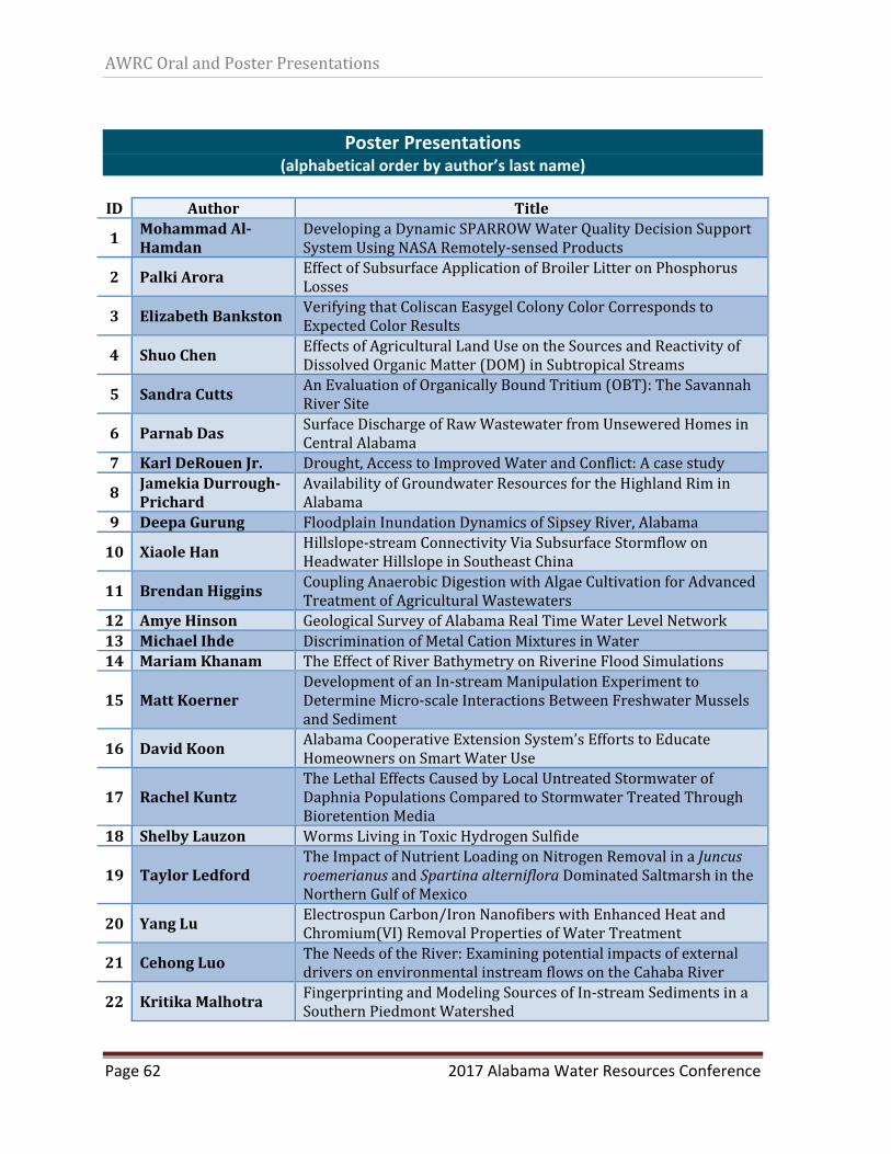
AWRCOralandPosterPresentations
Page 62 2017 Alabama Water Resources Conference
Poster Presentations
(alphabetical order by author’s last name)
ID Author Title
1MohammadAl‐Hamdan
DevelopingaDynamicSPARROWWaterQualityDecisionSupportSystemUsingNASARemotely‐sensedProducts
2 PalkiArora EffectofSubsurfaceApplicationofBroilerLitteronPhosphorusLosses
3 ElizabethBankstonVerifyingthatColiscanEasygelColonyColorCorrespondstoExpectedColorResults
4 ShuoChen EffectsofAgriculturalLandUseontheSourcesandReactivityofDissolvedOrganicMatter(DOM)inSubtropicalStreams
5 SandraCuttsAnEvaluationofOrganicallyBoundTritium(OBT):TheSavannahRiverSite
6 ParnabDas SurfaceDischargeofRawWastewaterfromUnseweredHomesinCentralAlabama
7 KarlDeRouenJr. Drought,AccesstoImprovedWaterandConflict:Acasestudy
8 JamekiaDurrough‐Prichard
AvailabilityofGroundwaterResourcesfortheHighlandRiminAlabama
9 DeepaGurung FloodplainInundationDynamicsofSipseyRiver,Alabama
10 XiaoleHanHillslope‐streamConnectivityViaSubsurfaceStormflowonHeadwaterHillslopeinSoutheastChina
11 BrendanHiggins CouplingAnaerobicDigestionwithAlgaeCultivationforAdvancedTreatmentofAgriculturalWastewaters
12 AmyeHinson GeologicalSurveyofAlabamaRealTimeWaterLevelNetwork13 MichaelIhde DiscriminationofMetalCationMixturesinWater14 MariamKhanam TheEffectofRiverBathymetryonRiverineFloodSimulations
15 MattKoernerDevelopmentofanIn‐streamManipulationExperimenttoDetermineMicro‐scaleInteractionsBetweenFreshwaterMusselsandSediment
16 DavidKoonAlabamaCooperativeExtensionSystem’sEffortstoEducateHomeownersonSmartWaterUse
17 RachelKuntzTheLethalEffectsCausedbyLocalUntreatedStormwaterofDaphniaPopulationsComparedtoStormwaterTreatedThroughBioretentionMedia
18 ShelbyLauzon WormsLivinginToxicHydrogenSulfide
19 TaylorLedfordTheImpactofNutrientLoadingonNitrogenRemovalinaJuncusroemerianusandSpartinaalternifloraDominatedSaltmarshintheNorthernGulfofMexico
20 YangLu ElectrospunCarbon/IronNanofiberswithEnhancedHeatandChromium(VI)RemovalPropertiesofWaterTreatment
21 CehongLuoTheNeedsoftheRiver:ExaminingpotentialimpactsofexternaldriversonenvironmentalinstreamflowsontheCahabaRiver
22 KritikaMalhotra FingerprintingandModelingSourcesofIn‐streamSedimentsinaSouthernPiedmontWatershed
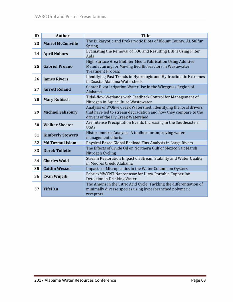
AWRCOralandPosterPresentations
2017 Alabama Water Resources Conference Page 63
ID Author Title
23 MarielMcConville TheEukaryoticandProkaryoticBiotaofBlountCounty,ALSulfurSpring
24 AprilNaborsEvaluatingtheRemovalofTOCandResultingDBP’sUsingFilterAids
25 GabrielProanoHighSurfaceAreaBiofilterMediaFabricationUsingAdditiveManufacturingforMovingBedBioreactorsinWastewaterTreatmentProcess
26 JamesRiversIdentifyingPastTrendsinHydrologicandHydroclimaticExtremesinCoastalAlabamaWatersheds
27 JarrettRoland CenterPivotIrrigationWaterUseintheWiregrassRegionofAlabama
28 MaryRubischTidal‐flowWetlandswithFeedbackControlforManagementofNitrogeninAquacultureWastewater
29 MichaelSalisburyAnalysisofD’OliveCreekWatershed:IdentifyingthelocaldriversthathaveledtostreamdegradationandhowtheycomparetothedriversoftheFlyCreekWatershed
30 WalkerSkeeterAreIntensePrecipitationEventsIncreasingintheSoutheasternUSA?
31 KimberlyStowers HistoriometricAnalysis:Atoolboxforimprovingwatermanagementefforts
32 MdTazmulIslam PhysicalBasedGlobalBedloadFluxAnalysisinLargeRivers
33 DerekTollette TheEffectsofCrudeOilonNorthernGulfofMexicoSaltMarshNitrogenCycling
34 CharlesWaid StreamRestorationImpactonStreamStabilityandWaterQualityinMooresCreek,Alabama
35 CaitlinWessel ImpactsofMicroplasticsintheWaterColumnonOysters
36 EvanWujcik Fabric/MWCNTNanosensorforUltra‐PortableCopperIonDetectioninDrinkingWater
37 YifeiXuTheAnionsintheCitricAcidCycle:Tacklingthedifferentiationofminimallydiversespeciesusinghyperbranchedpolymericreceptors
AWRCOralandPosterPresentations
Page 64 2017 Alabama Water Resources Conference
Forfurtherinformation,pleaseseetheconferencewebsite:
http://aaes.auburn.edu/wrc/extension‐outreach/awrc‐conference/


