THE A agash - maine.gov · Waterway, your plans should include contingencies for windy days, which...
1
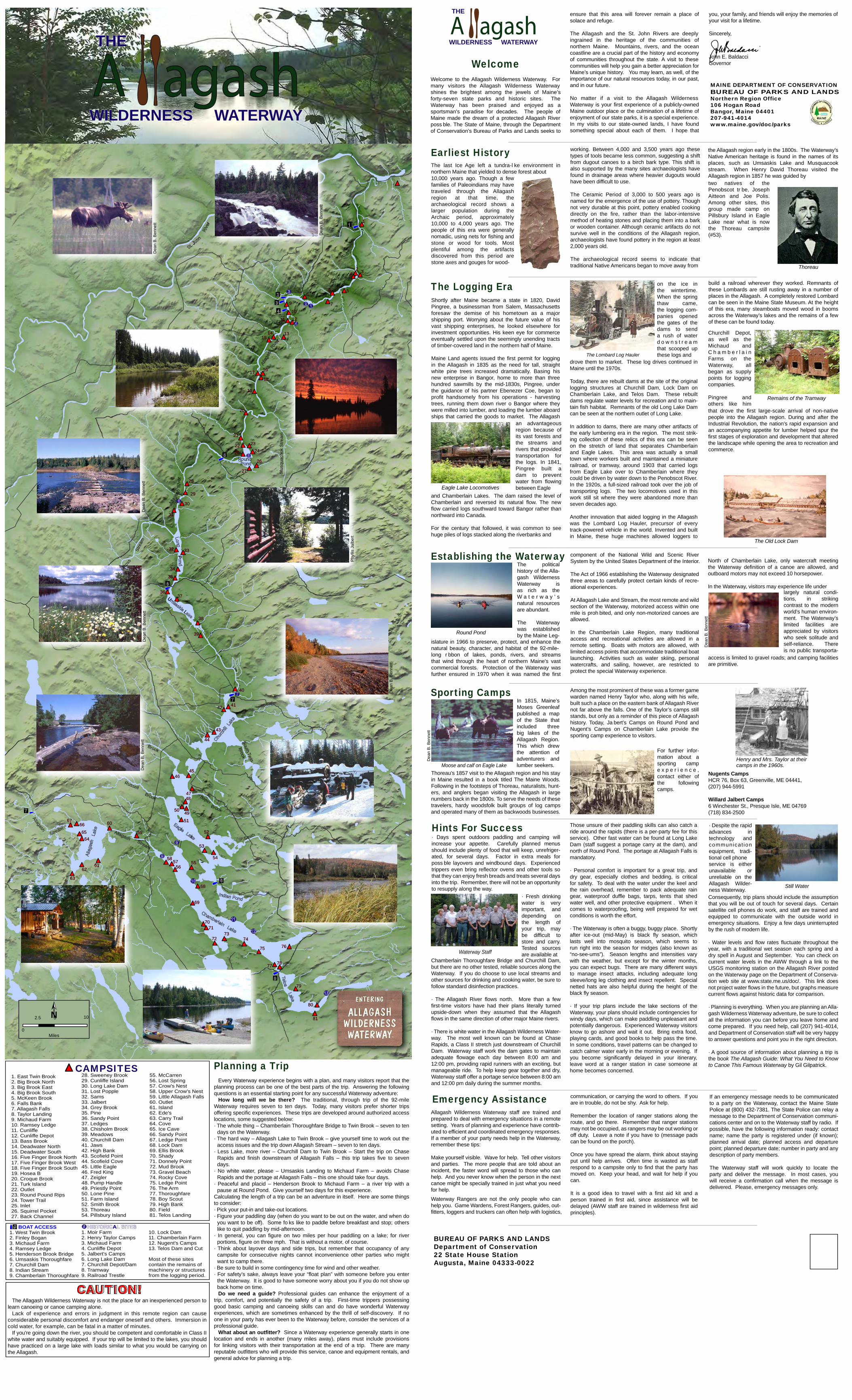
0 N Miles 5 2.5 1 1 2 2 3 3 4 4 5 5 6 6 7 7 8 8 9 9 10 10 1 1 1 1 12 12 13 13 14 14 15 15 16 16 17 17 18 18 19 19 20 20 21 21 22 22 23 23 24 24 25 25 26 26 27 27 28 28 29 29 30 30 31 31 32 32 33 33 34 34 35 35 36 36 37 37 38 38 39 39 40 40 42 42 41 41 45 45 46 46 44 44 43 43 47 47 48 48 49 49 50 50 51 51 52 52 54 54 53 53 55 55 56 56 58 58 59 59 57 57 60 60 61 61 62 62 63 63 64 64 65 65 66 66 67 67 69 69 68 68 70 70 71 71 72 72 73 73 74 74 75 75 76 76 77 77 78 78 79 79 80 80 81 81 A agash WILDERNESS WATERWAY THE Thoreau A agash WILDERNESS W A TERW A Y THE 10 MAINE DEPARTMENT OF CONSERVATION BUREAU OF PARKS AND LANDS Northern Region Office 106 Hogan Road Bangor, Maine 04401 207-941-4014 www.maine.gov/doc/parks Ross Stream Musquacook Stream Brook Brook Russell Allagash Stream South Brook Soper Allagash Stream Smith Brook T win Brook l k U L P l l r J r The last Ice Age left a tundra-l ke environment in northern Maine that yielded to dense forest about Earliest History Shortly after Maine became a state in 1820, David Pingree, a businessman from Salem, Massachusetts foresaw the demise of his hometown as a major shipping port. Worrying about the future value of his vast shipping enterprises, he looked elsewhere for investment opportunities. His keen eye for commerce eventually settled upon the seemingly unending tracts of timber-covered land in the northern half of Maine. Maine Land agents issued the first permit for logging in the Allagash in 1835 as the need for tall, straight white pine trees increased dramatically. Basing his new enterprise in Bangor, home to more than three hundred sawmills by the mid-1830s, Pingree, under the guidance of his partner Ebenezer Coe, began to profit handsomely from his operations - harvesting trees, running them down river o Bangor where they were milled into lumber, and loading the lumber aboard ships that carried the goods to market. The Allagash on the ice in the wintertime. When the spring thaw came, the logging com- panies opened the gates of the dams to send a rush of water downstream that scooped up these logs and The Logging Era The political history of the Alla- gash Wilderness Waterway is as rich as the Waterway’s natural resources are abundant. The Waterway was established by the Maine Leg- Establishing the Waterway Those unsure of their paddling skills can also catch a ride around the rapids (there is a per-party fee for this service). Other fast water can be found at Long Lake Dam (staff suggest a portage carry at the dam), and north of Round Pond. The portage at Allagash Falls is mandatory. · Personal comfort is important for a great trip, and dry gear, especially clothes and bedding, is critical for safety. To deal with the water under the keel and the rain overhead, remember to pack adequate rain gear, waterproof duffle bags, tarps, tents that shed water well, and other protective equipment . When it comes to waterproofing, being well prepared for wet conditions is worth the effort. · The Waterway is often a buggy, buggy place. Shortly after ice-out (mid-May) is black fly season, which lasts well into mosquito season, which seems to run right into the season for midges (also known as “no-see-ums”). Season lengths and intensities vary with the weather, but except for the winter months, you can expect bugs. There are many different ways to manage insect attacks, including adequate long sleeve/long leg clothing and insect repellent. Special netted hats are also helpful during the height of the black fly season. · If your trip plans include the lake sections of the Waterway, your plans should include contingencies for windy days, which can make paddling unpleasant and potentially dangerous. Experienced Waterway visitors know to go ashore and wait it out. Bring extra food, playing cards, and good books to help pass the time. In some conditions, travel patterns can be changed to catch calmer water early in the morning or evening. If you become significantly delayed in your itinerary, leave word at a ranger station in case someone at home becomes concerned. Hints For Success Allagash Wilderness Waterway staff are trained and prepared to deal with emergency situations in a remote setting. Years of planning and experience have contrib- uted to efficient and coordinated emergency responses. If a member of your party needs help in the Waterway, remember these tips: Make yourself visible. Wave for help. Tell other visitors and parties. The more people that are told about an incident, the faster word will spread to those who can help. And you never know when the person in the next canoe might be specially trained in just what you need for help. Waterway Rangers are not the only people who can help you. Game Wardens, Forest Rangers, guides, out- fitters, loggers and truckers can often help with logistics, communication, or carrying the word to others. If you are in trouble, do not be shy. Ask for help. Remember the location of ranger stations along the route, and go there. Remember that ranger stations may not be occupied, as rangers may be out working or off duty. Leave a note if you have to (message pads can be found on the porch). Once you have spread the alarm, think about staying put until help arrives. Often time is wasted as staff respond to a campsite only to find that the party has moved on. Keep your head, and wait for help if you can. It is a good idea to travel with a first aid kit and a person trained in first aid, since assistance will be delayed (AWW staff are trained in wilderness first aid principles). Emergency Assistance The Lombard Log Hauler BOAT ACCESS 1. West Twin Brook 2. Finley Bogan 3. Michaud Farm 4. Ramsey Ledge 5. Henderson Brook Bridge 6. Umsaskis Thoroughfare 7. Churchill Dam 8. Indian Stream 9. Chamberlain Thoroughfare 1. East Twin Brook 2. Big Brook North 3. Big Brook East 4. Big Brook South 5. McKeen Brook 6. Falls Bank 7. Allagash Falls 8. Taylor Landing 9. Michaud Farm 10. Ramsey Ledge 11. Cunliffe 12. Cunliffe Depot 13. Bass Brook 14. Deadwater North 15. Deadwater South 16. Five Finger Brook North 17. Five Finger Brook West 18. Five Finger Brook South 19. Hosea B 20. Croque Brook 21. Turk Island 22. Outlet 23. Round Pound Rips 24. Tower Trail 25. Inlet 26. Squirrel Pocket 27. Back Channel CAMPSITES CAUTION! The Allagash Wilderness Waterway is not the place for an inexperienced person to learn canoeing or canoe camping alone. Lack of experience and errors in judgment in this remote region can cause considerable personal discomfort and endanger oneself and others. Immersion in cold water, for example, can be fatal in a matter of minutes. If you're going down the river, you should be competent and comfortable in Class II white water and suitably equipped. If your trip will be limited to the lakes, you should have practiced on a large lake with loads similar to what you would be carrying on the Allagash. build a railroad wherever they worked. Remnants of these Lombards are still rusting away in a number of places in the Allagash. A completely restored Lombard can be seen in the Maine State Museum. At the height of this era, many steamboats moved wood in booms across the Waterway’s lakes and the remains of a few of these can be found today. If an emergency message needs to be communicated to a party on the Waterway, contact the Maine State Police at (800) 432-7381. The State Police can relay a message to the Department of Conservation communi- cations center and on to the Waterway staff by radio. If possible, have the following information ready: contact name; name the party is registered under (if known); planned arrival date; planned access and departure point; planned departure date; number in party and any description of party members. The Waterway staff will work quickly to locate the party and deliver the message. In most cases, you will receive a confirmation call when the message is delivered. Please, emergency messages only. 28. Sweeney Brook 29. Cunliffe Island 30. Long Lake Dam 31. Lost Popple 32. Sams 33. Jalbert 34. Grey Brook 35. Pine 36. Sandy Point 37. Ledges 38. Chisholm Brook 39. Meadows 40. Churchill Dam 41. Jaws 42. High Bank 43. Scofield Point 44. Scofield Cove 45. Little Eagle 46. Fred King 47. Zeigler 48. Pump Handle 49. Priestly Point 50. Lone Pine 51. Farm Island 52. Smith Brook 53. Thoreau 54. Pillsbury Island 55. McCarren 56. Lost Spring 57. Crow's Nest 58. Upper Crow's Nest 59. Little Allagash Falls 60. Outlet 61. Island 62. Ede's 63. Carry Trail 64. Cove 65. Ice Cave 66. Sandy Point 67. Ledge Point 68. Lock Dam 69. Ellis Brook 70. Shady 71. Donnely Point 72. Mud Brook 73. Gravel Beach 74. Rocky Cove 75. Ledge Point 76. The Arm 77. Thoroughfare 78. Boy Scout 79. High Bank 80. Field 81. Telos Landing A 1. Moir Farm 2. Henry Taylor Camps 3. Michaud Farm 4. Cunliffe Depot 5. Jalbert's Camps 6. Long Lake Dam 7. Churchill Depot/Dam 8. Tramway 9. Railroad Trestle 10. Lock Dam 11. Chamberlain Farm 12. Nugent's Camps 13. Telos Dam and Cut Most of these sites contain the remains of machinery or structures from the logging period. Planning a Trip Every Waterway experience begins with a plan, and many visitors report that the planning process can be one of the best parts of the trip. Answering the following questions is an essential starting point for any successful Waterway adventure: How long will we be there? The traditional, through trip of the 92-mile Waterway requires seven to ten days. Today, many visitors prefer shorter trips offering specific experiences. These trips are developed around authorized access locations, some suggested below: · The whole thing – Chamberlain Thoroughfare Bridge to Twin Brook – seven to ten days on the Waterway. · The hard way – Allagash Lake to Twin Brook – give yourself time to work out the access issues and the trip down Allagash Stream – seven to ten days. · Less Lake, more river – Churchill Dam to Twin Brook – Start the trip on Chase Rapids and finish downstream of Allagash Falls – this trip takes five to seven days. · No white water, please – Umsaskis Landing to Michaud Farm – avoids Chase Rapids and the portage at Allagash Falls – this one should take four days. · Peaceful and placid – Henderson Brook to Michaud Farm – a river trip with a pause at Round Pond. Give yourself two days for this experience. Calculating the length of a trip can be an adventure in itself. Here are some things to consider: · Pick your put-in and take-out locations. · Figure your paddling day (when do you want to be out on the water, and when do you want to be off). Some fo ks like to paddle before breakfast and stop; others like to quit paddling by mid-afternoon. · In general, you can figure on two miles per hour paddling on a lake; for river portions, figure on three mph. That is without a motor, of course. · Think about layover days and side trips, but remember that occupancy of any campsite for consecutive nights cannot inconvenience other parties who might want to camp there. · Be sure to build in some contingency time for wind and other weather. · For safety’s sake, always leave your “float plan” with someone before you enter the Waterway. It is good to have someone worry about you if you do not show up back home on time. Do we need a guide? Professional guides can enhance the enjoyment of a trip, comfort, and potentially the safety of a trip. First-time trippers possessing good basic camping and canoeing skills can and do have wonderful Waterway experiences, which are sometimes enhanced by the thrill of self-discovery. If no one in your party has ever been to the Waterway before, consider the services of a professional guide. What about an outfitter? Since a Waterway experience generally starts in one location and ends in another (many miles away), plans must include provisions for linking visitors with their transportation at the end of a trip. There are many reputable outfitters who will provide this service, canoe and equipment rentals, and general advice for planning a trip. Welcome Remains of the Tramway The Old Lock Dam islature in 1966 to preserve, protect, and enhance the natural beauty, character, and habitat of the 92-mile- long r bbon of lakes, ponds, rivers, and streams that wind through the heart of northern Maine's vast commercial forests. Protection of the Waterway was further ensured in 1970 when it was named the first component of the National Wild and Scenic River System by the United States Department of the Interior. The Act of 1966 establishing the Waterway designated three areas to carefully protect certain kinds of recre- ational experiences. At Allagash Lake and Stream, the most remote and wild section of the Waterway, motorized access within one mile is proh bited, and only non-motorized canoes are allowed. In the Chamberlain Lake Region, many traditional access and recreational activities are allowed in a remote setting. Boats with motors are allowed, with limited access points that accommodate traditional boat launching. Activities such as water skiing, personal watercrafts, and sailing, however, are restricted to protect the special Waterway experience. North of Chamberlain Lake, only watercraft meeting the Waterway definition of a canoe are allowed, and outboard motors may not exceed 10 horsepower. In the Waterway, visitors may experience life under access is limited to gravel roads; and camping facilities are primitive. drove them to market. These log drives continued in Maine until the 1970s. Today, there are rebuilt dams at the site of the original logging structures at Churchill Dam, Lock Dam on Chamberlain Lake, and Telos Dam. These rebuilt dams regulate water levels for recreation and to main- tain fish habitat. Remnants of the old Long Lake Dam can be seen at the northern outlet of Long Lake. In addition to dams, there are many other artifacts of the early lumbering era in the region. The most strik- ing collection of these relics of this era can be seen on the stretch of land that separates Chamberlain and Eagle Lakes. This area was actually a small town where workers built and maintained a miniature railroad, or tramway, around 1903 that carried logs from Eagle Lake over to Chamberlain where they could be driven by water down to the Penobscot River. In the 1920s, a full-sized railroad took over the job of transporting logs. The two locomotives used in this work still sit where they were abandoned more than seven decades ago. Another innovation that aided logging in the Allagash was the Lombard Log Hauler, precursor of every track-powered vehicle in the world. Invented and built in Maine, these huge machines allowed loggers to Eagle Lake Locomotives · Fresh drinking water is very important, and depending on the length of your trip, may be difficult to store and carry. Tested sources are available at Chamberlain Thoroughfare Bridge and Churchill Dam, but there are no other tested, reliable sources along the Waterway. If you do choose to use local streams and other sources for drinking and cooking water, be sure to follow standard disinfection practices. · The Allagash River flows north. More than a few first-time visitors have had their plans literally turned upside-down when they assumed that the Allagash flows in the same direction of other major Maine rivers. · There is white water in the Allagash Wilderness Water- way. The most well known can be found at Chase Rapids, a Class II stretch just downstream of Churchill Dam. Waterway staff work the dam gates to maintain adequate flowage each day between 8:00 am and 12:00 pm, providing rapid runners with an exciting, but manageable ride. To help keep gear together and dry, Waterway staff offer a portage service between 8:00 am and 12:00 pm daily during the summer months. and Chamberlain Lakes. The dam raised the level of Chamberlain and reversed its natural flow. The new flow carried logs southward toward Bangor rather than northward into Canada. For the century that followed, it was common to see huge piles of logs stacked along the riverbanks and Churchill Depot, as well as the Michaud and Chamberlain Farms on the Waterway, all began as supply points for logging companies. Pingree and others like him 10,000 years ago. Though a few families of Paleoindians may have traveled through the Allagash region at that time, the archaeological record shows a larger population during the Archaic period, approximately 10,000 to 4,000 years ago. The people of this era were generally nomadic, using nets for fishing and stone or wood for tools. Most plentiful among the artifacts discovered from this period are stone axes and gouges for wood- working. Between 4,000 and 3,500 years ago these types of tools became less common, suggesting a shift from dugout canoes to a birch bark type. This shift is also supported by the many sites archaeologists have found in drainage areas where heavier dugouts would have been difficult to use. The Ceramic Period of 3,000 to 500 years ago is named for the emergence of the use of pottery. Though not very durable at this point, pottery enabled cooking directly on the fire, rather than the labor-intensive method of heating stones and placing them into a bark or wooden container. Although ceramic artifacts do not survive well in the conditions of the Allagash region, archaeologists have found pottery in the region at least 2,000 years old. The archaeological record seems to indicate that traditional Native Americans began to move away from the Allagash region early in the 1800s. The Waterway’s Native American heritage is found in the names of its places, such as Umsaskis Lake and Musquacook stream. When Henry David Thoreau visited the Allagash region in 1857 he was guided by an advantageous region because of its vast forests and the streams and rivers that provided transportation for the logs. In 1841, Pingree built a dam to prevent water from flowing between Eagle largely natural condi- tions, in striking contrast to the modern world’s human environ- ment. The Waterway’s limited facilities are appreciated by visitors who seek solitude and self-reliance. There is no public transporta- In 1815, Maine’s Moses Greenleaf published a map of the State that included three big lakes of the Allagash Region. This which drew the attention of adventurers and lumber seekers. Sporting Camps Thoreau’s 1857 visit to the Allagash region and his stay in Maine resulted in a book titled The Maine Woods. Following in the footsteps of Thoreau, naturalists, hunt- ers, and anglers began visiting the Allagash in large numbers back in the 1800s. To serve the needs of these travelers, hardy woodsfolk built groups of log camps and operated many of them as backwoods businesses. Among the most prominent of these was a former game warden named Henry Taylor who, along with his wife, built such a place on the eastern bank of Allagash River not far above the falls. One of the Taylor’s camps still stands, but only as a reminder of this piece of Allagash history. Today, Jabert’s Camps on Round Pond and Nugent’s Camps on Chamberlain Lake provide the sporting camp experience to visitors. · Despite the rapid advances in technology and communication equipment, tradi- tional cell phone service is either unavailable or unreliable on the Allagash Wilder- ness Waterway. For further infor- mation about a sporting camp experience, contact either of the following camps. two natives of the Penobscot tr be, Joseph Aitteon and Joe Polis. Among other sites, this group made camp on Pillsbury Island in Eagle Lake near what is now the Thoreau campsite (#53). Waterway Staff · Days spent outdoors paddling and camping will increase your appetite. Carefully planned menus should include plenty of food that will keep, unrefriger- ated, for several days. Factor in extra meals for poss ble layovers and windbound days. Experienced trippers even bring reflector ovens and other tools so that they can enjoy fresh breads and treats several days into the trip. Remember, there will not be an opportunity to resupply along the way. Nugents Camps HCR 76, Box 63, Greenville, ME 04441, (207) 944-5991 Willard Jalbert Camps 6 Winchester St., Presque Isle, ME 04769 (718) 834-2500 Henry and Mrs. Taylor at their camps in the 1960s. that drove the first large-scale arrival of non-native people into the Allagash region. During and after the Industrial Revolution, the nation’s rapid expansion and an accompanying appetite for lumber helped spur the first stages of exploration and development that altered the landscape while opening the area to recreation and commerce. Round Pond Moose and calf on Eagle Lake Still Water Consequently, trip plans should include the assumption that you will be out of touch for several days. Certain satellite cell phones do work, and staff are trained and equipped to communicate with the outside world in emergency situations. Enjoy a few days uninterrupted by the rush of modern life. · Water levels and flow rates fluctuate throughout the year, with a traditional wet season each spring and a dry spell in August and September. You can check on current water levels in the AWW through a link to the USGS monitoring station on the Allagash River posted on the Waterway page on the Department of Conserva- tion web site at www.state.me.us/doc/. This link does not project water flows in the future, but graphs measure current flows against historic data for comparison. · Planning is everything. When you are planning an Alla- gash Wilderness Waterway adventure, be sure to collect all the information you can before you leave home and come prepared. If you need help, call (207) 941-4014, and Department of Conservation staff will be very happy to answer questions and point you in the right direction. · A good source of information about planning a trip is the book The Allagash Guide: What You Need to Know to Canoe This Famous Waterway by Gil Gilpatrick. BUREAU OF PARKS AND LANDS Department of Conservation 22 State House Station Augusta, Maine 04333-0022 Welcome to the Allagash Wilderness Waterway. For many visitors the Allagash Wilderness Waterway shines the brightest among the jewels of Maine’s forty-seven state parks and historic sites. The Waterway has been praised and enjoyed as a sportsman's paradise for decades. The people of Maine made the dream of a protected Allagash River poss ble. The State of Maine, through the Department of Conservation’s Bureau of Parks and Lands seeks to ensure that this area will forever remain a place of solace and refuge. The Allagash and the St. John Rivers are deeply ingrained in the heritage of the communities of northern Maine. Mountains, rivers, and the ocean coastline are a crucial part of the history and economy of communities throughout the state. A visit to these communities will help you gain a better appreciation for Maine’s unique history. You may learn, as well, of the importance of our natural resources today, in our past, and in our future. No matter if a visit to the Allagash Wilderness Waterway is your first experience of a publicly-owned Maine outdoor place or the culmination of a lifetime of enjoyment of our state parks, it is a special experience. In my visits to our state-owned lands, I have found something special about each of them. I hope that you, your family, and friends will enjoy the memories of your visit for a lifetime. Sincerely, John E. Baldacci Governor Dean B. Bennett Dean B. Bennett Dean B. Bennett Dean B. Bennett Phyllis Jalbert Dean B. Bennett Dean B. Bennett Dean B. Bennett Dean B. Bennett
Transcript of THE A agash - maine.gov · Waterway, your plans should include contingencies for windy days, which...
0
N
Miles
52.5
1 1
2 2 3 3 4 4
5 5 6 6
7 7
8 8
9 9
10 10
1 1 1 1 12 12
13 13 14 14 15 15
16 16 17 17 18 18
19 19
20 20
21 21
22 22 23 23 24 24 25 25
26 26
27 27
28 28
29 29
30 30
31 31
32 32 33 33
34 34
35 35
36 36 37 37
38 38
39 39
40 40
42 42 41 41
45 45 46 46
44 44
43 43
47 47 48 48
49 49 50 50
51 51
52 52
54 54
53 53
55 55 56 56
58 58
59 59
57 57
60 60
61 61 62 62
63 63
64 64 65 65
66 66 67 67
69 69
68 68
70 70 71 71
72 72 73 73
74 74
75 75 76 76
77 77 78 78
79 79
80 80
81 81
A agash WILDERNESS WATERWAY
THE
Thoreau
A agash WILDERNESS W A TE R W A Y
THE
10
MAINE DEPARTMENT OF CONSERVATION BUREAU OF PARKS AND LANDS Northern Region Office 106 Hogan Road Bangor, Maine 04401 207-941-4014 www.maine.gov/doc/parks
Ross
Stre
am
Mus
quac
ook
Stre
am
Brook
Brook
Russell
Allagash
Stream
South
Brook
Soper
Allagash Stream
Smith Brook
T wi n
Brook
l k
U
L
P
l
l
r
J
r
The last Ice Age left a tundra-l ke environment in northern Maine that yielded to dense forest about
Earliest History
Shortly after Maine became a state in 1820, David Pingree, a businessman from Salem, Massachusetts foresaw the demise of his hometown as a major shipping port. Worrying about the future value of his vast shipping enterprises, he looked elsewhere for investment opportunities. His keen eye for commerce eventually settled upon the seemingly unending tracts of timber-covered land in the northern half of Maine.
Maine Land agents issued the first permit for logging in the Allagash in 1835 as the need for tall, straight white pine trees increased dramatically. Basing his new enterprise in Bangor, home to more than three hundred sawmills by the mid-1830s, Pingree, under the guidance of his partner Ebenezer Coe, began to profit handsomely from his operations - harvesting trees, running them down river o Bangor where they were milled into lumber, and loading the lumber aboard ships that carried the goods to market. The Allagash
on the ice in the wintertime. When the spring thaw came, the logging com-panies opened the gates of the dams to send a rush of water d o w n s t r e a m that scooped up these logs and
The Logging Era
The political history of the Alla-gash Wilderness Waterway is as rich as the W a t e r w a y ’ s natural resources are abundant.
The Waterway was established by the Maine Leg-
Establishing the Waterway
Those unsure of their paddling skills can also catch a ride around the rapids (there is a per-party fee for this service). Other fast water can be found at Long Lake Dam (staff suggest a portage carry at the dam), and north of Round Pond. The portage at Allagash Falls is mandatory.
· Personal comfort is important for a great trip, and dry gear, especially clothes and bedding, is critical for safety. To deal with the water under the keel and the rain overhead, remember to pack adequate rain gear, waterproof duffle bags, tarps, tents that shed water well, and other protective equipment . When it comes to waterproofing, being well prepared for wet conditions is worth the effort.
· The Waterway is often a buggy, buggy place. Shortly after ice-out (mid-May) is black fly season, which lasts well into mosquito season, which seems to run right into the season for midges (also known as “no-see-ums”). Season lengths and intensities vary with the weather, but except for the winter months, you can expect bugs. There are many different ways to manage insect attacks, including adequate long sleeve/long leg clothing and insect repellent. Special netted hats are also helpful during the height of the black fly season.
· If your trip plans include the lake sections of the Waterway, your plans should include contingencies for windy days, which can make paddling unpleasant and potentially dangerous. Experienced Waterway visitors know to go ashore and wait it out. Bring extra food, playing cards, and good books to help pass the time. In some conditions, travel patterns can be changed to catch calmer water early in the morning or evening. If you become significantly delayed in your itinerary, leave word at a ranger station in case someone at home becomes concerned.
Hints For Success
Allagash Wilderness Waterway staff are trained and prepared to deal with emergency situations in a remote setting. Years of planning and experience have contrib-uted to efficient and coordinated emergency responses. If a member of your party needs help in the Waterway, remember these tips:
Make yourself visible. Wave for help. Tell other visitors and parties. The more people that are told about an incident, the faster word will spread to those who can help. And you never know when the person in the next canoe might be specially trained in just what you need for help.
Waterway Rangers are not the only people who can help you. Game Wardens, Forest Rangers, guides, out-fitters, loggers and truckers can often help with logistics,
communication, or carrying the word to others. If you are in trouble, do not be shy. Ask for help.
Remember the location of ranger stations along the route, and go there. Remember that ranger stations may not be occupied, as rangers may be out working or off duty. Leave a note if you have to (message pads can be found on the porch).
Once you have spread the alarm, think about staying put until help arrives. Often time is wasted as staff respond to a campsite only to find that the party has moved on. Keep your head, and wait for help if you can.
It is a good idea to travel with a first aid kit and a person trained in first aid, since assistance will be delayed (AWW staff are trained in wilderness first aid principles).
Emergency Assistance
The Lombard Log Hauler
BOAT ACCESS 1. West Twin Brook 2. Finley Bogan 3. Michaud Farm 4. Ramsey Ledge 5. Henderson Brook Bridge 6. Umsaskis Thoroughfare 7. Churchill Dam 8. Indian Stream 9. Chamberlain Thoroughfare
1. East Twin Brook 2. Big Brook North 3. Big Brook East 4. Big Brook South 5. McKeen Brook 6. Falls Bank 7. Allagash Falls 8. Taylor Landing 9. Michaud Farm 10. Ramsey Ledge 11. Cunliffe 12. Cunliffe Depot 13. Bass Brook 14. Deadwater North 15. Deadwater South 16. Five Finger Brook North 17. Five Finger Brook West 18. Five Finger Brook South 19. Hosea B 20. Croque Brook 21. Turk Island 22. Outlet 23. Round Pound Rips 24. Tower Trail 25. Inlet 26. Squirrel Pocket 27. Back Channel
CAMPSITES
CAUTION! The Allagash Wilderness Waterway is not the place for an inexperienced person to
learn canoeing or canoe camping alone. Lack of experience and errors in judgment in this remote region can cause
considerable personal discomfort and endanger oneself and others. Immersion in cold water, for example, can be fatal in a matter of minutes.
If you're going down the river, you should be competent and comfortable in Class II white water and suitably equipped. If your trip will be limited to the lakes, you should have practiced on a large lake with loads similar to what you would be carrying on the Allagash.
build a railroad wherever they worked. Remnants of these Lombards are still rusting away in a number of places in the Allagash. A completely restored Lombard can be seen in the Maine State Museum. At the height of this era, many steamboats moved wood in booms across the Waterway’s lakes and the remains of a few of these can be found today.
If an emergency message needs to be communicated to a party on the Waterway, contact the Maine State Police at (800) 432-7381. The State Police can relay a message to the Department of Conservation communi-cations center and on to the Waterway staff by radio. If possible, have the following information ready: contact name; name the party is registered under (if known); planned arrival date; planned access and departure point; planned departure date; number in party and any description of party members.
The Waterway staff will work quickly to locate the party and deliver the message. In most cases, you will receive a confirmation call when the message is delivered. Please, emergency messages only.
28. Sweeney Brook 29. Cunliffe Island 30. Long Lake Dam 31. Lost Popple 32. Sams 33. Jalbert 34. Grey Brook 35. Pine 36. Sandy Point 37. Ledges 38. Chisholm Brook 39. Meadows 40. Churchill Dam 41. Jaws 42. High Bank 43. Scofield Point 44. Scofield Cove 45. Little Eagle 46. Fred King 47. Zeigler 48. Pump Handle 49. Priestly Point 50. Lone Pine 51. Farm Island 52. Smith Brook 53. Thoreau 54. Pillsbury Island
55. McCarren 56. Lost Spring 57. Crow's Nest 58. Upper Crow's Nest 59. Little Allagash Falls 60. Outlet 61. Island 62. Ede's 63. Carry Trail 64. Cove 65. Ice Cave 66. Sandy Point 67. Ledge Point 68. Lock Dam 69. Ellis Brook 70. Shady 71. Donnely Point 72. Mud Brook 73. Gravel Beach 74. Rocky Cove 75. Ledge Point 76. The Arm 77. Thoroughfare 78. Boy Scout 79. High Bank 80. Field 81. Telos Landing
A 1. Moir Farm 2. Henry Taylor Camps 3. Michaud Farm 4. Cunliffe Depot 5. Jalbert's Camps 6. Long Lake Dam 7. Churchill Depot/Dam 8. Tramway 9. Railroad Trestle
10. Lock Dam 11. Chamberlain Farm 12. Nugent's Camps 13. Telos Dam and Cut Most of these sites contain the remains of machinery or structures from the logging period.
Planning a TripEvery Waterway experience begins with a plan, and many visitors report that the
planning process can be one of the best parts of the trip. Answering the following questions is an essential starting point for any successful Waterway adventure:
How long will we be there? The traditional, through trip of the 92-mile Waterway requires seven to ten days. Today, many visitors prefer shorter trips offering specific experiences. These trips are developed around authorized access locations, some suggested below:· The whole thing – Chamberlain Thoroughfare Bridge to Twin Brook – seven to ten
days on the Waterway.· The hard way – Allagash Lake to Twin Brook – give yourself time to work out the
access issues and the trip down Allagash Stream – seven to ten days.· Less Lake, more river – Churchill Dam to Twin Brook – Start the trip on Chase
Rapids and finish downstream of Allagash Falls – this trip takes five to seven days.
· No white water, please – Umsaskis Landing to Michaud Farm – avoids Chase Rapids and the portage at Allagash Falls – this one should take four days.
· Peaceful and placid – Henderson Brook to Michaud Farm – a river trip with a pause at Round Pond. Give yourself two days for this experience.
Calculating the length of a trip can be an adventure in itself. Here are some things to consider:· Pick your put-in and take-out locations.· Figure your paddling day (when do you want to be out on the water, and when do
you want to be off). Some fo ks like to paddle before breakfast and stop; others like to quit paddling by mid-afternoon.
· In general, you can figure on two miles per hour paddling on a lake; for river portions, figure on three mph. That is without a motor, of course.
· Think about layover days and side trips, but remember that occupancy of any campsite for consecutive nights cannot inconvenience other parties who might want to camp there.
· Be sure to build in some contingency time for wind and other weather.· For safety’s sake, always leave your “float plan” with someone before you enter
the Waterway. It is good to have someone worry about you if you do not show up back home on time.Do we need a guide? Professional guides can enhance the enjoyment of a
trip, comfort, and potentially the safety of a trip. First-time trippers possessing good basic camping and canoeing skills can and do have wonderful Waterway experiences, which are sometimes enhanced by the thrill of self-discovery. If no one in your party has ever been to the Waterway before, consider the services of a professional guide.
What about an outfitter? Since a Waterway experience generally starts in one location and ends in another (many miles away), plans must include provisions for linking visitors with their transportation at the end of a trip. There are many reputable outfitters who will provide this service, canoe and equipment rentals, and general advice for planning a trip.
Welcome
Remains of the Tramway
The Old Lock Dam
islature in 1966 to preserve, protect, and enhance the natural beauty, character, and habitat of the 92-mile-long r bbon of lakes, ponds, rivers, and streams that wind through the heart of northern Maine's vast commercial forests. Protection of the Waterway was further ensured in 1970 when it was named the first
component of the National Wild and Scenic River System by the United States Department of the Interior.
The Act of 1966 establishing the Waterway designated three areas to carefully protect certain kinds of recre-ational experiences.
At Allagash Lake and Stream, the most remote and wild section of the Waterway, motorized access within one mile is proh bited, and only non-motorized canoes are allowed.
In the Chamberlain Lake Region, many traditional access and recreational activities are allowed in a remote setting. Boats with motors are allowed, with limited access points that accommodate traditional boat launching. Activities such as water skiing, personal watercrafts, and sailing, however, are restricted to protect the special Waterway experience.
North of Chamberlain Lake, only watercraft meeting the Waterway definition of a canoe are allowed, and outboard motors may not exceed 10 horsepower.
In the Waterway, visitors may experience life under
access is limited to gravel roads; and camping facilities are primitive.
drove them to market. These log drives continued in Maine until the 1970s.
Today, there are rebuilt dams at the site of the original logging structures at Churchill Dam, Lock Dam on Chamberlain Lake, and Telos Dam. These rebuilt dams regulate water levels for recreation and to main-tain fish habitat. Remnants of the old Long Lake Dam can be seen at the northern outlet of Long Lake.
In addition to dams, there are many other artifacts of the early lumbering era in the region. The most strik-ing collection of these relics of this era can be seen on the stretch of land that separates Chamberlain and Eagle Lakes. This area was actually a small town where workers built and maintained a miniature railroad, or tramway, around 1903 that carried logs from Eagle Lake over to Chamberlain where they could be driven by water down to the Penobscot River. In the 1920s, a full-sized railroad took over the job of transporting logs. The two locomotives used in this work still sit where they were abandoned more than seven decades ago.
Another innovation that aided logging in the Allagash was the Lombard Log Hauler, precursor of every track-powered vehicle in the world. Invented and built in Maine, these huge machines allowed loggers to
Eagle Lake Locomotives
· Fresh drinking water is very important, and depending on the length of your trip, may be difficult to store and carry. Tested sources are available at
Chamberlain Thoroughfare Bridge and Churchill Dam, but there are no other tested, reliable sources along the Waterway. If you do choose to use local streams and other sources for drinking and cooking water, be sure to follow standard disinfection practices.
· The Allagash River flows north. More than a few first-time visitors have had their plans literally turned upside-down when they assumed that the Allagash flows in the same direction of other major Maine rivers.
· There is white water in the Allagash Wilderness Water-way. The most well known can be found at Chase Rapids, a Class II stretch just downstream of Churchill Dam. Waterway staff work the dam gates to maintain adequate flowage each day between 8:00 am and 12:00 pm, providing rapid runners with an exciting, but manageable ride. To help keep gear together and dry, Waterway staff offer a portage service between 8:00 am and 12:00 pm daily during the summer months.
and Chamberlain Lakes. The dam raised the level of Chamberlain and reversed its natural flow. The new flow carried logs southward toward Bangor rather than northward into Canada.
For the century that followed, it was common to see huge piles of logs stacked along the riverbanks and
Churchill Depot, as well as the Michaud and C h a m b e r l a i n Farms on the Waterway, all began as supply points for logging companies.
Pingree and others like him
10,000 years ago. Though a few families of Paleoindians may have traveled through the Allagash region at that time, the archaeological record shows a larger population during the Archaic period, approximately 10,000 to 4,000 years ago. The people of this era were generally nomadic, using nets for fishing and stone or wood for tools. Most plentiful among the artifacts discovered from this period are stone axes and gouges for wood-
working. Between 4,000 and 3,500 years ago these types of tools became less common, suggesting a shift from dugout canoes to a birch bark type. This shift is also supported by the many sites archaeologists have found in drainage areas where heavier dugouts would have been difficult to use. The Ceramic Period of 3,000 to 500 years ago is named for the emergence of the use of pottery. Though not very durable at this point, pottery enabled cooking directly on the fire, rather than the labor-intensive method of heating stones and placing them into a bark or wooden container. Although ceramic artifacts do not survive well in the conditions of the Allagash region, archaeologists have found pottery in the region at least 2,000 years old.
The archaeological record seems to indicate that traditional Native Americans began to move away from
the Allagash region early in the 1800s. The Waterway’s Native American heritage is found in the names of its places, such as Umsaskis Lake and Musquacook stream. When Henry David Thoreau visited the Allagash region in 1857 he was guided by
an advantageous region because of its vast forests and the streams and rivers that provided transportation for the logs. In 1841, Pingree built a dam to prevent water from flowing between Eagle
largely natural condi-tions, in striking contrast to the modern world’s human environ-ment. The Waterway’s limited facilities are appreciated by visitors who seek solitude and self-reliance. There is no public transporta-
In 1815, Maine’s Moses Greenleaf published a map of the State that included three big lakes of the Allagash Region. This which drew the attention of adventurers and lumber seekers.
Sporting Camps
Thoreau’s 1857 visit to the Allagash region and his stay in Maine resulted in a book titled The Maine Woods. Following in the footsteps of Thoreau, naturalists, hunt-ers, and anglers began visiting the Allagash in large numbers back in the 1800s. To serve the needs of these travelers, hardy woodsfolk built groups of log camps and operated many of them as backwoods businesses.
Among the most prominent of these was a former game warden named Henry Taylor who, along with his wife, built such a place on the eastern bank of Allagash River not far above the falls. One of the Taylor’s camps still stands, but only as a reminder of this piece of Allagash history. Today, Ja bert’s Camps on Round Pond and Nugent’s Camps on Chamberlain Lake provide the sporting camp experience to visitors.
· Despite the rapid advances in technology and communicat ion equipment, tradi-tional cell phone service is either unavailable or unreliable on the Allagash Wilder-ness Waterway.
For further infor-mation about a sporting camp e x p e r i e n c e , contact either of the following camps.
two natives of the Penobscot tr be, Joseph Aitteon and Joe Polis. Among other sites, this group made camp on Pillsbury Island in Eagle Lake near what is now the Thoreau campsite (#53).
Waterway Staff
· Days spent outdoors paddling and camping will increase your appetite. Carefully planned menus should include plenty of food that will keep, unrefriger-ated, for several days. Factor in extra meals for poss ble layovers and windbound days. Experienced trippers even bring reflector ovens and other tools so that they can enjoy fresh breads and treats several days into the trip. Remember, there will not be an opportunity to resupply along the way.
Nugents Camps HCR 76, Box 63, Greenville, ME 04441, (207) 944-5991 Willard Jalbert Camps 6 Winchester St., Presque Isle, ME 04769 (718) 834-2500
Henry and Mrs. Taylor at their camps in the 1960s.
that drove the first large-scale arrival of non-native people into the Allagash region. During and after the Industrial Revolution, the nation’s rapid expansion and an accompanying appetite for lumber helped spur the first stages of exploration and development that altered the landscape while opening the area to recreation and commerce.
Round Pond
Moose and calf on Eagle Lake
Still Water
Consequently, trip plans should include the assumption that you will be out of touch for several days. Certain satellite cell phones do work, and staff are trained and equipped to communicate with the outside world in emergency situations. Enjoy a few days uninterrupted by the rush of modern life.
· Water levels and flow rates fluctuate throughout the year, with a traditional wet season each spring and a dry spell in August and September. You can check on current water levels in the AWW through a link to the USGS monitoring station on the Allagash River posted on the Waterway page on the Department of Conserva-tion web site at www.state.me.us/doc/. This link does not project water flows in the future, but graphs measure current flows against historic data for comparison.
· Planning is everything. When you are planning an Alla-gash Wilderness Waterway adventure, be sure to collect all the information you can before you leave home and come prepared. If you need help, call (207) 941-4014, and Department of Conservation staff will be very happy to answer questions and point you in the right direction.
· A good source of information about planning a trip is the book The Allagash Guide: What You Need to Know to Canoe This Famous Waterway by Gil Gilpatrick.
BUREAU OF PARKS AND LANDS Department of Conservation 22 State House Station Augusta, Maine 04333-0022
Welcome to the Allagash Wilderness Waterway. For many visitors the Allagash Wilderness Waterway shines the brightest among the jewels of Maine’s forty-seven state parks and historic sites. The Waterway has been praised and enjoyed as a sportsman's paradise for decades. The people of Maine made the dream of a protected Allagash River poss ble. The State of Maine, through the Department of Conservation’s Bureau of Parks and Lands seeks to
ensure that this area will forever remain a place of solace and refuge. The Allagash and the St. John Rivers are deeply ingrained in the heritage of the communities of northern Maine. Mountains, rivers, and the ocean coastline are a crucial part of the history and economy of communities throughout the state. A visit to these communities will help you gain a better appreciation for Maine’s unique history. You may learn, as well, of the importance of our natural resources today, in our past, and in our future. No matter if a visit to the Allagash Wilderness Waterway is your first experience of a publicly-owned Maine outdoor place or the culmination of a lifetime of enjoyment of our state parks, it is a special experience. In my visits to our state-owned lands, I have found something special about each of them. I hope that
you, your family, and friends will enjoy the memories of your visit for a lifetime. Sincerely,
John E. Baldacci Governor
Dea
n B.
Ben
nett
Dea
n B.
Ben
nett
Dea
n B.
Ben
nett
Dea
n B.
Ben
nett
Phyl
lis J
albe
rt
Dea
n B.
Ben
nett
Dea
n B.
Ben
nett
Dea
n B.
Ben
nett
Dea
n B.
Ben
nett