TEXAS COASTALour coastal communities, including the Coastal Texas Study with the U.S. Army Corps of...
36
George P. Bush, Commissioner Texas General Land Office EXECUTIVE SUMMARY – MARCH 2017 TEXAS COASTAL RESILIENCY MASTER PLAN
Transcript of TEXAS COASTALour coastal communities, including the Coastal Texas Study with the U.S. Army Corps of...

George P. Bush, CommissionerTexas General Land Office
E X E C U T I V E S U M M A R Y – M A R C H 2 0 1 7
T E X A S COA STA L R E S I L I E N C Y M A S T E R P L A N

Texas General Land Officeb Executive Summary – Texas Coastal Resiliency Master Plan
Plan Overview
Cover photographs, clockwise from top:
Whooping Cranes on the Matagorda Island Unit of the Aransas National Wildlife Refuge.
Port of Galveston.
View of Seawall Boulevard on Galveston Island.
Recreational fishing boat in Port Aransas Ship Channel.

Texas General Land Office c Executive Summary – Texas Coastal Resiliency Master Plan
Plan Overview
Message from the CommissionerAs the Commissioner of the Texas General Land Office, I am committed to making sure that this state does all it can to protect the people, economy and natural resources of the Texas coast. A region that is vitally important to not just this state, but the entire nation. The Texas coast is home to the Gulf Intracoastal Waterway, the nation’s third busiest inland waterway15, 25 percent of the nation’s refining capacity26, four of the 15 busiest ports in the country23, most of the nation’s strategic petroleum reserves24, numerous strategic military deployment and distribution installations, and a vital tourism industry. This economic activity is supported by beach and dune systems, wetlands and other coastal natural resources that serve as natural barriers to protect against storm surge and coastal flooding. However, 65 percent of the Texas Gulf shoreline is eroding at an average rate of more than 2 feet per year, and in some areas much more rapidly, which is leaving our homes, businesses and the state’s entire coastline vulnerable.22
The Texas Coastal Resiliency Master Plan (Plan) is an important step to provide a framework for community, economic, ecologic and infrastructure protection from coastal hazards. This framework consists of recommended projects to enhance and protect the coast, and resiliency strategies that will require partner coordination to implement. In addition to this Plan, the General Land Office is conducting several separate studies to help protect our coastal communities, including the Coastal Texas Study with the U.S. Army Corps of Engineers that will determine the feasibility of constructing storm risk mitigation and large-scale environmental restoration projects for the entire Texas coast.
The need for the Texas Coastal Resiliency Master Plan and these other coastal studies has never been greater, and the commitment to the coast has never been stronger in this state. The Plan will help us mitigate impacts on our coast and to our communities.
George P. Bush, Commissioner, Texas General Land Office
South Padre Island beach access point.

Inner harbor of the Port of Corpus Christi.

Texas General Land Office 1 Executive Summary – Texas Coastal Resiliency Master Plan
Plan Overview
As a powerful economic engine and an invaluable environmental treasure, the Texas coast is vital to the success of the state and the nation. Its beautiful natural resources such as beaches, dunes, wetlands, oyster reefs and rookery islands — providing more than just recreational opportunities — play a critical role in protecting coastal communities from storm surge and flooding. Our coastal resources also contribute to the state and national economies by safeguarding and supporting industries such as petroleum refining, petrochemical, chemical and plastics manufacturing, waterborne commerce through the expansive network of Texas ports, commercial and recreational fishing, and tourism.
The Texas coast, however, is vulnerable to coastal hazards, and is placing people, economic assets and communities at risk. The hazards include aging infrastructure along major navigation channels, erosion of large swaths of Gulf and bay shorelines, continual degradation of water quality to coastal estuaries, and potential flooding and surge damages from the next big storm. Past storms, such as Hurricane Ike and Hurricane Dolly, were environmentally and economically damaging to the Texas coast, and portions of the coast are still recovering.4
In June 2012, Houston and Galveston were identified as the fifth most vulnerable of U.S. cities to hurricanes because of their low-lying coastal location, large population and critical economic infrastructure.6 This ranking should come as no surprise, given that the entire nation felt Hurricane Ike’s rippling economic impacts. Due to the closure of the ports of Houston and Galveston, as well as the Houston Ship Channel, gas prices skyrocketed in the Midwest and the South.2 There was also an interruption of supply chains for consumer goods, such as food, beverages and clothes, as nearly 150 tankers, container ships and cargo vessels waited offshore in the days following Hurricane Ike’s landfall until the port could be re-opened.8 These local and national effects clearly emphasize the need for coastal protection and the urgency to create resilient natural and built environments along the Texas coast. They highlight the need for innovative planning to restore, improve and revitalize communities in advance of impacts, not only from coastal storms, but also from the persistent issues that threaten the vitality and productivity of the region.
Coastal planning is essential to articulate the importance of the coast and acquire the much needed funding to implement appropriate solutions. The Texas Coastal Resiliency Master Plan (Plan) highlights the value of the coast and the hazards that endanger the environment and the economy of the coastal communities. The Plan also provides a list of projects and strategies to address those problems – ensuring that the Texas coast is more resilient today, and for generations to come.
The Importance of the Texas Coast and the Need for a Coastal Plan
Flooding in Kemah after Hurricane Ike, 2008.
Port O’Connor after Hurricane Claudette, 2003.

Texas General Land Office2 Executive Summary – Texas Coastal Resiliency Master Plan
Plan Overview
The GLO’s Vision for a Resilient Texas CoastCoastal protection is a priority of Texas Land Commissioner, George P. Bush. As the steward of state-owned lands, the Texas General Land Office (GLO) is responsible for management of the Texas coastline from tidally influenced streams and riverbeds, and out to 10.3 miles into the Gulf of Mexico. In alignment with the GLO’s mission to restore, enhance and protect the state’s coastal natural resources while fostering economic growth, Commissioner Bush directed the development of the Texas Coastal Resiliency Master Plan to help coastal communities become more resilient and less vulnerable to coastal storms and hazards.
The Plan embraces the GLO’s vision for a resilient coast that supports and sustains a strong economy and healthy environment for all who live, work, play or otherwise benefit from coastal resources and the natural and built environment along the Texas coast, now and in the future.
The Texas Coastal Resiliency Master Plan also is a coordinative vehicle that complements various coastal planning and coastal management initiatives of other entities at the federal, state and local levels. The Plan will actively guide the GLO in the execution of its responsibilities and provide Texas coastal communities with a set of scientifically sound, feasible and cost-effective coastal protection and restoration projects to advance coastal resiliency. This planning process is not a one-time undertaking. The Plan will continuously evolve along with the concerns and needs of the coast and its residents to ensure that recurrent and up-to-date coastal management is provided to the coastal communities.
The Texas Coastal Resiliency Master Plan
Planning GoalsWithin the planning framework are three goals and associated objectives that collectively yield recommended projects to achieve a resilient coast.• Goal 1: The GLO will use the Plan to direct its
authority to restore, enhance and protect the Texas coast.
• Goal 2: Maintain ongoing communication with the Technical Advisory Committee, resource agencies and stakeholders throughout Plan development and implementation to garner support for the Plan.
• Goal 3: Develop an adaptable plan that accommodates changing coastal conditions and their impacts on the coastal environment and the infrastructure protected by this natural first line of defense.
Planning ScopeThe scope of the Plan is focused on nature-based projects to enhance coastal resiliency. For the purposes of the Plan, resiliency is defined as the ability of coastal systems and infrastructure to withstand – and rebound from – natural and human-induced disturbances. When a coastal community is resilient, significant adverse impacts from such disturbances are reduced or eliminated, and the community can rebound more effectively in those instances where negative impacts cannot be avoided. A resilient natural system can better protect the built environment by absorbing or mitigating impacts from disturbances, and return more quickly to a stable state.
The Plan also highlights the environmental and economic characterization of the Texas coast to showcase the invaluable contributions the coast provides to local communities, the state and the nation.
View of Corpus Christi from Bayside Park in Portland.
Port Aransas shoreline.

Texas General Land Office 3 Executive Summary – Texas Coastal Resiliency Master Plan
Plan Overview
CAMERON
WILLACY
KENEDY
KLEBERG
NUECES
SAN PATRICIO
REFUGIO
VICTORIA
JACKSONMATAGORDA
BRAZORIA
GALVESTON
HARRISCHAMBERS
JEFFERSON
ORANGE
CAMERON
WILLACY
KENEDY
KLEBERG
NUECES
SAN PATRICIO
REFUGIO
ARANSAS
VICTORIA
JACKSONMATAGORDA
BRAZORIA
GALVESTON
HARRISCHAMBERS
JEFFERSON
ORANGE
Galveston
Freeport
Galveston
Houston
Freeport
Port Arthur
CALHOUN
Galveston Bay
Port LavacaPort Lavaca
Matagorda Bay Matagorda Bay
San Antonio Bay
Ba�n Bay
Corpus Christi BayCorpus Christi Bay
Copano Bay
Port IsabelPort Isabel
Laguna MadreLaguna Madre
Region 1
Region 2
Region 3
Region 4
Corpus ChristiCorpus Christi
CAMERON
WILLACY
KENEDY
KLEBERG
NUECES
SAN PATRICIO
REFUGIO
VICTORIA
JACKSONMATAGORDA
BRAZORIA
GALVESTON
HARRISCHAMBERS
JEFFERSON
ORANGE
CAMERON
WILLACY
KENEDY
KLEBERG
NUECES
SAN PATRICIO
REFUGIO
ARANSAS
VICTORIA
JACKSONMATAGORDA
BRAZORIA
GALVESTON
HARRISCHAMBERS
JEFFERSON
ORANGE
Galveston
Freeport
Galveston
Houston
Freeport
Port Arthur
CALHOUN
Galveston Bay
Port LavacaPort Lavaca
Matagorda Bay Matagorda Bay
San Antonio Bay
Ba�n Bay
Corpus Christi BayCorpus Christi Bay
Copano Bay
Port IsabelPort Isabel
Laguna MadreLaguna Madre
Region 1
Region 2
Region 3
Region 4
Corpus ChristiCorpus Christi
Coastal Issues of ConcernA component of the Texas Coastal Resiliency Master Plan is the identification and evaluation of the natural and human-induced disturbances, which are referred to as Issues of Concern (IOCs) in the Plan. The IOCs are listed below and are described in more detail on pages 8-10:• Altered, Degraded or Lost Habitat• Gulf Beach Erosion and Dune Degradation• Bay Shoreline Erosion• Existing and Future Coastal Storm Surge Damage• Coastal Flood Damage• Impacts on Water Quality and Quantity• Impacts on Coastal Resources• Abandoned or Derelict Vessels, Structures and Debris
The Plan recognizes that the issues affecting the Texas coast are relentless, and the consequences of inaction are profound. The coastal Issues of Concern will not resolve themselves, and if left unaddressed, will continue to have adverse impacts on infrastructure, natural resources, economic activities, and the health and safety of residents.
Planning AreaThe planning area of the Texas Coastal Resiliency Master Plan is the Texas Coastal Zone Boundary from the Texas Coastal Management Program, which is the area the GLO is required to regulate through state and federal laws. This area is immense — making up one-tenth of the state’s total land area and including over 6 million residents, representing nearly 25 percent of the state’s total population.18 Because the Texas coastal zone is ecologically diverse, for the purposes of this planning effort, the coast is broken up into four regions to provide a more focused assessment of the needs in these coastal areas. All or portions of the following counties are included in these four regions:
• Region 1 - Brazoria, Chambers, Galveston, Harris, Jefferson and Orange;
• Region 2 - Calhoun, Jackson, Matagorda and Victoria;• Region 3 - Aransas, Kleberg, Nueces, Refugio and San
Patricio; and• Region 4 - Cameron, Kenedy and Willacy.

Texas General Land Office4 Executive Summary – Texas Coastal Resiliency Master Plan
Plan Overview
Planning TeamTo assist with the development of the Plan, the GLO partnered with contractors and an academic institution for engineering services, data analysis and mapping, and facilitation of education and outreach activities.
To gather information on the specific Issues of Concern affecting the Texas coast and to evaluate potential solutions to address these challenges, the GLO formed a Technical Advisory Committee (TAC), a group of coastal experts from state and federal agencies, universities, local governments, non-profits, engineering firms, port representatives, and regional trusts, foundations and partnerships. The TAC members are an integral component of the development of the Plan who serve as subject matter experts on a regional and statewide level, and provide input and technical guidance throughout the entire planning process. A complete listing of the TAC member affiliations is included in the Acknowledgments section of the Plan.
Technical Advisory Committee (TAC) Members:• State & federal agencies• Universities• Local governments• Non-profits• Engineering firms• Port representatives• Regional trusts,
foundations & partnerships
Technical Advisory Committee and local officials meeting in Houston.
Aerial view of Port Aransas and Harbor Island.

Texas General Land Office 5 Executive Summary – Texas Coastal Resiliency Master Plan
Plan Overview
The Planning ProcessThe planning framework began by compiling an initial list of over 900 coastal projects through a comprehensive literature review of past and current coastal planning documents and databases, as well as through stakeholder consultation. The first screening process removed projects that did not have sufficient information or were duplications.
Concurrently, while the project lists were assembled and screened, Issues of Concern were identified as they relate to coastal resiliency. Identification of the Issues of Concern were derived from an understanding of the Pressures exerted on the coastal system (such as tropical storms, hurricanes, depletion of freshwater inflows, sediment deficits, infrastructure and development) that stem from social, economic and natural Drivers. The TAC evaluated the level of concern for all Issues of Concern, in terms of coastal resiliency, within each of the four coastal regions that were divided into 68 subregions and primarily defined by watershed extents. Included in the 68 subregions are four Gulf-facing beach and dune subregions created to examine the Pressures facing the barrier island and peninsula beach and dune systems. High levels of concern imply the need for project solutions to address the IOCs in the specified areas.
A second project screening identified the environmental benefits and physical capabilities of the projects to address the Issues of Concern, which reduced the list of candidate projects to 177. During a series of regional meetings, the 177 projects were subjected to additional evaluation by the TAC, who assessed each project based on how the project addressed the IOCs within that area, the feasibility of executing the project and whether the project was a priority for coastal resiliency. The TAC also were asked to provide additional gap projects that could address the Issues of Concern and were not included in the 177 projects they evaluated at the meetings. The TAC submitted and evaluated 61 gap projects.
Following the TAC’s assessment of initial and gap projects, an additional technical analysis was conducted, which considered project costs, economic benefits, physical and risk impacts, environmental impacts and sediment availability. This technical assessment in conjunction with TAC input, resulted in the designation of Tier 1 projects (high priority) and Tier 2 and Tier 3 projects. Only Tier 1 projects are listed in the Plan and the Executive Summary. Tier 2 and Tier 3 projects are recorded in the Plan’s appendix and will be further considered in future iterations of the Plan.
DevelopPlanning
Framework
Identify Projects
for Evaluation
1st Screening 2nd Screening
DevelopIssues of Concern
Project Screening
Develop Project
Evaluation Criteria &
Methodology
Further Define
Projects
Prepare First
Iteration Resiliency Strategies
Analyze Existing Data
& Information• Project Lists• Technical
References• Ongoing &
Completed Studies
TAC Assessment of Issues of
Concern
TAC Project
Evaluation & Gap
Projects Submitted
TAC Gap ProjectAnalysis
TAC & Local Official Review of Projects and
Resiliency Strategies
Additional Technical Analysis of Projects• Physical Systems• Cost/Benefits• Environmental
Impacts• Feasibility
Identify Next Steps• Gap Analysis• Ongoing TAC Review• Enhance First
Iteration Resiliency Strategies
Plan2017
BeginPlanMarch2016
NextSteps
The Planning Process

Texas General Land Office6 Executive Summary – Texas Coastal Resiliency Master Plan
Plan Overview
Resiliency StrategiesPost-TAC project analysis revealed that across the regions there were common project types, due to the common Issues of Concern identified regionwide. Similar project types, addressing similar Issues of Concern, were grouped into Resiliency Strategies to provide multiple lines of defense solutions. The Resiliency Strategies also are intended to provide a system-wide approach within each coastal region to maximize the benefits of the projects when they are implemented collectively. Each Tier 1 project included in the Plan is assigned to the Resiliency Strategy that best describes its focus, recognizing that any given project may have secondary benefits that relate to other Resiliency Strategies. The Resiliency Strategies are as follows:
• Restoration of Beaches and Dunes – Provides renourishment of sediment to beach and dune complexes to address erosion, shoreline loss and limited sediment supply.
• Bay Shoreline Stabilization and Estuarine Wetland Restoration (Living Shorelines) – Addresses shoreline erosion problems within bay and estuarine systems and will provide shoreline stabilization through combined shoreline protection and habitat creation projects (e.g., living shorelines).
• Stabilizing the Texas Gulf Intracoastal Waterway (GIWW) – Addresses critical shoreline erosion, habitat loss and environmental degradation problems along the GIWW or other navigation channels.
• Freshwater Wetlands and Coastal Uplands Conservation – Conserves and protects ecologically significant freshwater wetlands and coastal uplands through various land acquisition, conservation and restoration projects.
• Delta and Lagoon Restoration – Mitigates hydrologic and water quality impairments within major delta and lagoon systems along the coast.
• Oyster Reef Creation and Restoration – Provides for the identification and restoration or re-establishment of productive oyster reefs.
• Rookery Island Creation and Restoration – Provides for the identification and restoration or re-establishment of rookery island nesting habitats to support colonial waterbird populations.
• Plans, Policies and Programs – Establishes a framework to address coastal resiliency priorities through legislative and administrative changes and coastal program enhancements.
Restorationof Beaches
& Dunes
Bay ShorelineStabilization& Estuarine
WetlandRestoration
Stabilizingthe Texas
GIWW
FreshwaterWetlands &
Coastal UplandsConservation
Delta &Lagoon
Restoration
Oyster ReefCreation &Restoration
RookeryIsland
Creation &Restoration
Plans,Policies
& Programs
ResiliencyStrategies

Texas General Land Office 7 Executive Summary – Texas Coastal Resiliency Master Plan
Plan Overview
Plan Implementation and Next StepsThe Texas Coastal Resiliency Master Plan will be used by the General Land Office to guide and enhance the various coastal programs it manages, with the goal of protecting, restoring and enhancing the Texas coast through an efficient and cost-effective approach to achieve a resilient coast. The Plan also can be used by coastal communities to highlight the Issues of Concern in their region, and to solicit action to fund the coastal projects that can make their communities more resilient and less vulnerable to the next big storm.
The GLO utilizes an adaptive approach in the development of the Plan, recognizing that it is a living document to be updated and amended based on evolving issues, needs and societal preferences. This ability to adapt will ensure that the Plan will provide a long-term framework to protect the environment and economic assets from the Issues of Concern that threaten the communities along the Texas coast.
Future iterations of the Plan will reflect a greater depth and breadth of analysis as the planning process matures, and as additional data and analytical techniques are developed. Subsequent planning is also expected to include additional emphasis on life cycle and phasing aspects of recommended projects, an enhanced focus on storm surge defense and flood risk reduction, restoration of water quality, and community development and revitalization to achieve a more robust and resilient coast.
Bird and wetlands near development in Rockport.
Leonabelle Turnbull Birding Center in Port Aransas.

Texas General Land Office8 Executive Summary – Texas Coastal Resiliency Master Plan
Plan Overview
Coastal Issues of ConcernThe Issues of Concern represent the problems introduced by the dominant Drivers and Pressures facing the Texas coast. Addressing these IOCs is the primary goal when evaluating methods to improve coastal resiliency. Project solutions that can mitigate or eliminate the IOCs in a feasible and cost effective manner are considered the most resilient solutions for the coast. Identifying where specific IOCs exist and the severity to which they impact Texas’ environments at the time of this study, provided the basis to analyze projects for inclusion in the Plan. The Resiliency Strategy Framework diagram, shown below, displays the Drivers, Pressures and Issues of Concern that influence the current conditions of the coast, and provide the foundation for project selection and Resiliency Strategy development.
Altered, Degraded or Lost HabitatHealthy bays, wetlands and estuaries provide the critical foundation for sustainable environments and thriving economies. These coastal habitats help maintain wildlife and
plant populations, improve water quality, support fishing activities, enhance local tourism and maintain community resilience by reducing the impact of coastal hazards, such as flooding and storm surge. Coastal population growth, development and relative sea level rise adversely impact coastal habitats, and this effect will continue unless mitigation projects are implemented.
Issues of Concern identified and addressed by the Plan are as follows:
Rollover Pass on the Bolivar Peninsula.
Drivers
Planning Framework
Social
Economic
Natural
Natural Processes & Human Activities(e.g. sea level rise,storm intensity,
over fishing, oil & gas development)
Issues of ConcernPressures
IndicatorsExamples:
Trends in Losses of Habitat
Decrease in Freshwater Inflow
Expert Assessment
Current Condition
Resiliency Strategies/Projects
Environmental Health Human Well-BeingAltered, Degraded or Lost Habitat
Gulf Beach Erosion & Dune Degradation
Bay Shoreline Erosion
Existing & Future Coastal Storm Surge Damage
Coastal Flood Damage
Impact on Water Quality & Quantity
Impact on Coastal Resources
Abandoned or Derelict Vessels, Structures & Debris
Restoration of Beaches & Dunes
Bay Shoreline Stabilization & Estuarine Wetland Restoration
Stabilizing the Texas GIWW
Freshwater Wetlands & Coastal Uplands Conservation
Delta & Lagoon Restoration
Oyster Reef Creation & Restoration
Rookery Island Creation & Restoration
Plans, Policies & Programs
Resiliency Strategy Framework

Texas General Land Office 9 Executive Summary – Texas Coastal Resiliency Master Plan
Plan Overview
Gulf Beach Erosion and Dune DegradationApproximately 65 percent of the Texas Gulf shoreline is considered an eroding area. An eroding area is defined by state regulation as a portion of the shoreline eroding at a
rate of greater than 2 feet per year.17 Natural or restored Gulf beaches and dunes provide recreation areas and habitat for wildlife, including threatened and endangered species, such as sea turtles and piping plovers. Beaches and dunes also serve as a natural first line of defense from storm surge for inland populations and infrastructure by absorbing the impact of high waves and by stopping or delaying intrusion of water inland. Erosion is a threat to public beach use and access, public and private property and infrastructure, fish and wildlife habitat, and public health and safety. The combined effects of erosion are amplified by coastal population growth and increased development.
Bay Shoreline ErosionBay shorelines are experiencing many of the same issues as the Gulf-facing shorelines. Bay shore areas function as buffers, protecting upland habitats from erosion and storm damage,
and adjacent wetlands and waterways from water quality degradation. The loss of these bay shorelines from coastal development, vessel wakes along the Gulf Intracoastal Waterway, relative sea level rise, and wind and wave erosion contributes to habitat loss, water quality degradation, loss of property and reduced protection from storm surge and other coastal hazards.
Existing and Future Coastal Storm Surge DamageMaintaining the coast’s natural protective features is critical to minimizing the impact of future storms and hurricanes,
and their associated human, infrastructure and economic losses. Coastal storms present a major threat to people and property living near the coast, with many long-lasting impacts on community infrastructure, the natural environment and the local, state and national economies. Increased coastal development, erosion, relative sea level rise and wetland loss contribute to increased risk and exposure to coastal storm events.
Coastal Flood DamageMuch of the Texas coastal zone lies in a floodplain susceptible to storm and nuisance flooding that impacts and disrupts coastal communities, damages property and natural environments,
and poses risks to human health and safety. The impacts of coastal flooding may be exacerbated by increased floodplain development, wetland loss and ongoing processes such as erosion, subsidence and sea level rise. Continued landscape changes increase risk and exposure to hazards, even in areas not previously prone to flooding.

Texas General Land Office10 Executive Summary – Texas Coastal Resiliency Master Plan
Plan Overview
Impacts on Water Quality and QuantityIncreased urban development and water use places demands on water resources, and can negatively impact water quality and quantity. Poor water quality leads to habitat and wildlife
degradation, health and safety issues, and negative economic impacts on coastal communities, tourism, recreation and fishing. When coupled with the fact that Texas is a drought-prone state, freshwater inflows to Texas’ watersheds and bays are threatened. Adequate inflows are essential to support healthy coastal habitats and wildlife, water quality, salinity, recreation, and commercial activities, such as farming and fishing.
Impacts on Coastal ResourcesThe coastal zone of Texas boasts an abundance of resources, including oysters, turtles, birds, fish, crabs and several endangered species that are sensitive to environmental
changes. These resources are important to maintain the health of coastal systems, but also for the economy, as they support ecotourism and recreational and commercial fisheries, all of which generate tax revenue for the coastal communities and the state. These resources are impacted by various natural and human disturbances, including population growth, increased resource extraction, habitat loss from development, degraded habitat and water quality from pollution, reduced freshwater inflows, invasive species, disease, storms and salinity changes.
Abandoned or Derelict Vessels, Structures and DebrisAbandoned and derelict vessels, structures and other debris can become hazards to navigation as well as natural
resources, and can restrict and alter coastal processes. When left neglected, vessels and structures can sink or move during storms, disperse oil and toxic chemicals, destroy marine and coastal habitats, and affect the health and safety of residents and visitors of the coastal communities.10
Region OverviewsTo offer a better understanding of the current state of the Texas coast, region overviews are provided with environmental descriptions of the area and the priority Issues of Concern. The region overviews also include a listing of the Resiliency Strategies and Tier 1 recommended projects to address the identified Issues of Concern, the estimated project costs, and regional maps showing the project locations.

Texas General Land Office 11 Executive Summary – Texas Coastal Resiliency Master Plan
Plan OverviewRegion 1 Overview
Region 1, comprised of Brazoria, Chambers, Galveston, Harris, Jefferson and Orange counties, is the most heavily developed and densely populated region, with development covering approximately 14 percent of the region’s land area.11 This region contains a portion of the Greater Houston metropolitan area, Beaumont, Galveston and Texas City, among others, and the Texas Gulf Coast Refining District, with 5,000 energy-related companies and 15 of the 20 largest oil pipeline companies in the nation.3
Coinciding with the presence of industrial and urban development, this region is also home to expansive coastal resources. Region 1 includes Sabine Lake and the Galveston Bay System, which encompasses East Bay, Trinity Bay, West Bay and Christmas Bay. This system is known as the Trinity-San Jacinto estuary – the state’s largest estuary and the seventh largest in the United States.19 These bay systems support more than 244,000 acres of estuarine wetlands and 380,000 acres of freshwater wetlands.11 Oyster beds while abundant in this region, covering more than 27,000 acres of bay bottom5, suffered a 60 percent loss after Hurricane Ike and are still in need of restoration.4
The region’s coastal resources drew in visitor spending on recreation and tourism, totaling $766 million in 2015, with $153 million generated in tax revenues.20 However, the Gulf beach areas in this region are vulnerable to coastal hazards due to the rapid rate of erosion. About 74 percent of Gulf-facing beaches in this region are considered eroding areas. The average rate of shoreline erosion in these eroding areas is almost 10 feet per year.22 The high rate of erosion in this region can be partly attributed to a naturally sand-starved setting, exacerbated by engineered structures such as the dredged channels and jetties at Sabine Pass and Bolivar Roads that interrupt the longshore transport of sediments along Bolivar Peninsula and Galveston Island.9 Sand carried by longshore currents is trapped by the jetties, causing localized areas of shoreline accretion rather than being distributed further along the shoreline to assist with beach rebuilding.9
The priority Issues of Concern for Region 1 are:1. Gulf Beach Erosion and Dune Degradation – Some of
the highest rates of Gulf shoreline erosion in Texas occur in Jefferson County (almost 13 feet per year16) and to the west end of the Galveston
seawall. Additionally, much of the Galveston Island dune system that was washed out by Hurricane Ike has still not recovered, leaving the Houston/Galveston metropolitan area vulnerable to the next major storm.
2. Altered, Degraded or Lost Habitat – Critical habitats in Galveston Bay, such as wetlands, seagrass and oyster reefs suffered extreme losses from development, erosion, subsidence, invasive species and changing bay salinities.
3. Existing and Future Coastal Storm Surge Damage – Houston is the fourth most populated city in the United States, with the second largest port in terms of tonnage25 (Port of Houston), and is home
to the most important oil and gas production complexes in the United States.1 Due to the dense population and critical infrastructure, the region is highly vulnerable to coastal storm damage. These damages would also have nationwide economic impacts.
4. Coastal Flood Damage – High tide events, in combination with increased water in the watersheds from rain, flow into Galveston Bay and cause coastal flooding in the low-lying areas of the region and along
rivers and streams. These events cause disruptions, damage to property and natural environments, and pose risks to human health and safety.Beach on Galveston Island.
Boardwalk Park in Port Arthur.

Texas General Land Office12 Executive Summary – Texas Coastal Resiliency Master Plan
Plan Overview
Region 1 Recommended Resiliency Strategy SummaryTo address the priority Issues of Concern in this region, the Resiliency Strategies and projects in the table, and shown on the map, were identified as possible solutions:
Strategy ID Tier 1 Projects Estimated Cost Range
Restoration of Beaches and Dunes
R1-1 Bolivar Peninsula Beach & Dune Restoration $50 M - $95 M
R1-2 Follets Island Nourishment and Erosion Control $60 M - $115 M
R1-7 McFaddin National Wildlife Refuge Shoreline Restoration $100 M - $190 M
R1-22Galveston Island West of Seawall to 8 Mile Road Beach Nourishment
$2 M - $12 M
Bay Shoreline Stabilization and
Estuarine Wetland Restoration
(Living Shorelines)
R1-4 Old River Cove Marsh Restoration $10 M - $30 M
R1-8 Gordy Marsh Restoration & Shoreline Protection $15 M - $35 M
R1-10 Coastal Heritage Preserve – Phase 4 $3 M - $10 M
R1-11 Sweetwater Preserve Expansion $1 M - $3 M
R1-12 Pierce Marsh Living Shoreline $25 M - $45 M
R1-13 IH-45 Causeway Marsh Restoration $5 M - $18 M
R1-14 Moses Lake Wetlands Restoration – Phase 3 $1 M - $3.5 M
R1-18 Follets Island Marsh Restoration $30 M - $50 M
R1-21 Bessie Heights Marsh Restoration $5 M - $25 M
R1-23 Follets Island Conservation Initiative $4.5 M - $15 M
Stabilizing the Texas Gulf Intracoastal
Waterway
R1-3 Old River Cove Barrier Island Restoration $5 M - $15 M
R1-5 Anahuac National Wildlife Refuge Living Shoreline $50 M - $105 M
R1-6 Willow Lake Shoreline Stabilization $3 M - $8 M
R1-17 Brazoria National Wildlife Refuge GIWW Shoreline Protection $20 M - $35 M
R1-19 North Pleasure Island Barrier Island Restoration $1.5 M - $5 M
R1-20 Sabine-Neches Waterway Barrier Island Habitat Restoration $0.5 M - $1.5 M
Freshwater Wetlands and Coastal Uplands
Conservation
R1-15 Salt Bayou Siphons $3 M - $7 M
R1-24 Sabine Ranch Habitat Protection $65 M - $120 M
Oyster Reef Creation and Restoration
R1-25 Galveston Bay Oyster Reef Planning & Restoration $5 M - $60 M
Rookery Island Creation
and Restoration
R1-9 Galveston Bay Rookery Island Restoration $45 M - $80 M
R1-16 Dickinson Bay Rookery Island Restoration $0.5 M - $2 M
Total for Region 1: $510 M - $1.1 B
Region 1 Overview

Texas General Land Office 13 Executive Summary – Texas Coastal Resiliency Master Plan
Plan OverviewRegion 1 Counties:Brazoria, Chambers, Galveston, Harris, Jefferson and Orange
R2-1
R1-9R1-9
R1-9
R1-8
R1-7
R1-6
R1-5
R1-1
R1-15
R1-25
R1-24
R1-21
R1-16
R1-14
R1-15
HARRIS
LIBERTY
BRAZORIA
HARDIN
JEFFERSON
CHAMBERS
ORANGE
MONTGOMERY
SAN JACINTO
GALVESTONFORT BEND
JASPER
MATAGORDA
POLKNEWTON
WALKER ±1
34
2
MapExtents
0 20 4010Miles
R1-4
R1-3
R1-20
R1-19
ORANGE
JEFFERSON
R1-9R1-9
R1-2
R1-23R1-18R1-17
BRAZORIA
R1-9
R1-25
R1-25R1-22
R1-13R1-12
R1-11
R1-10
Resiliency Strategy Project Locations
D D D D
D D D D
D D D D
Stabilizing the GIWW
Freshwater Wetland & Coastal UplandsConservation
Oyster Reef Creation & Restoration
Restoration of Beaches & Dunes
Bay Shoreline Stabilization & Estuarine WetlandRestoration (Living Shorelines)
Rookery Island Creation & Restoration

Texas General Land Office14 Executive Summary – Texas Coastal Resiliency Master Plan
Plan Overview
Region 2, comprised of Calhoun, Jackson, Matagorda and Victoria counties, is the least developed of the four regions — only approximately 1 percent of the land area is developed.11 The lack of industrial and urban development allows for the presence of vast and valuable natural resources. Region 2 contains the bay systems of East Matagorda, Matagorda and the eastern portion of San Antonio Bay, which includes Espiritu Santo Bay and Mission Lake. This region has more than 144,000 acres of estuarine wetlands and 127,000 acres of freshwater wetlands.11
Relative to the other regions, Region 2 has the fewest eroding shorelines, with 58 percent of the Gulf shoreline considered an eroding area.22 However, the average rate of erosion along the shoreline is more than 11 feet per year,22 which can be attributed to a few very localized areas of extreme Gulf shoreline erosion on an otherwise relatively stable Gulf shoreline. Even with less development, these areas of Gulf shoreline erosion threaten important natural environments.
Shoreline erosion and wetland habitat loss threaten productive marshes and wetlands, as well as valuable bird rookeries. The GIWW cuts through protected wetlands in this region, and strong wakes from boat traffic contribute to high rates of channel erosion and wetland habitat loss.
The priority Issues of Concern for Region 2 are:1. Altered, Degraded or Lost Habitat – Erosion of the
wetlands and upland areas adjacent to the GIWW, and the reduction of freshwater inflows into the bay contribute to degradation of coastal habitats.
2. Gulf Beach Erosion and Dune Degradation – While the majority of the area experiences only moderate erosion, the upper Matagorda Peninsula and Sargent Beach experience erosion rates ranging from 12 feet to 24 feet per year.16
3. Impacts on Coastal Resources – Recreational and commercial fishing and other coastal activities are highly important to the culture and economy of this region, and are dependent upon the health of these natural environments.
4. Impacts on Water Quality and Quantity – The delivery of inadequate quantities of upstream freshwater into the San Antonio Bay system causes higher than normal salinity, which impacts fish and wildlife, including endangered species like the Whooping Crane.
Region 2 Recommended Resiliency Strategy SummaryTo address the priority Issues of Concern in this region, the Resiliency Strategies and projects in the table, and shown on the map, were identified as possible solutions:
Strategy ID Tier 1 Projects Estimated Cost Range
Restoration of Beaches & Dunes R2-7 Sargent Beach & Dune Restoration $45 M - $80 M
Bay Shoreline Stabilization and Estuarine Wetland Restoration
(Living Shorelines)
R2-6 Redfish Lake Living Shoreline $5 M - $15 M
R2-11 Schicke Point Living Shoreline $2.5 M - $7.5 M
Stabilizing the Texas Gulf Intracoastal Waterway
R2-1 Brazos River to Cedar Lake Creek GIWW Stabilization $35 M - $65 M
R2-2 Boggy Cut GIWW Stabilization $4.5 M - $13 M
Freshwater Wetlands and Coastal Uplands Conservation
R2-12Sargent Ranch Addition to San Bernard National Wildlife Refuge
$40 M - $80 M
Delta & Lagoon Restoration R2-8 Matagorda Bay System Hydrologic Restoration Study $1 M - $5 M
Oyster Reef Creation & Restoration
R2-4 Half Moon Oyster Reef Restoration – Phase 3 $2 M - $5 M
R2-5 Chinquapin Oyster Reef Restoration $1.5 M - $5 M
R2-9 Oliver Point Oyster Reef Restoration $1.5 M - $5 M
Rookery Island Creation & Restoration
R2-3 Chester’s Island Restoration $1.5 M - $5 M
R2-10 San Antonio Bay Rookery Island Restoration $6 M - $19 M
Total for Region 2: $145.5 M – $304.5 M
Region 2 Overview
Alcoa Bird Tower and coastal wetlands in Port Lavaca.

Texas General Land Office 15 Executive Summary – Texas Coastal Resiliency Master Plan
Plan OverviewRegion 2 Counties:Calhoun, Jackson, Matagorda and Victoria
BRAZORIA
FORT BEND
R1-17
R2-8
R2-8
R2-8
R2-8
R2-9
R2-8
R2-6
R3-7
R2-4
R2-3
R2-10
R2-11
MATAGORDA
JACKSON
WHARTON
CALHOUN
BRAZORIA
VICTORIA
REFUGIO
ARANSAS
COLORADO
LAVACA±
Resiliency Strategy Project LocationsRestoration of Beaches & Dunes
Bay Shoreline Stabilization & EstuarineWetland Restoration (Living Shorelines)
Rookery Island Creation & Restoration
D D D D
D D D D
D D D DStabilizing the GIWW
Delta & Lagoon Restoration
Freshwater Wetland & Coastal UplandsConservation
Oyster Reef Creation & Restoration
2 1
34
MapExtents
0 20 4010Miles
R2-5
R2-7
R2-2
R2-1
R2-12
MATAGORDA
BRAZORIA

Texas General Land Office16 Executive Summary – Texas Coastal Resiliency Master Plan
Plan Overview
Region 3, comprised of Aransas, Kleberg, Nueces, Refugio and San Patricio counties, is the second most developed region among the four. This region includes portions of the cities of Corpus Christi, Rockport, Port Aransas and Portland. Approximately 5 percent of the total land area is developed.11
Region 3 includes four major bay/lagoon systems – the western portion of the San Antonio Bay system, the Copano-Aransas Bay system, the Corpus Christi Bay system and the Upper Laguna Madre – the only hypersaline lagoon in the United States.19 This region has more than 76,000 acres of estuarine wetlands and a prevalent amount of seagrass beds at 65,600 acres.11 Bay shoreline erosion and coastal development contribute to habitat loss and jeopardize the health and water quality of this region’s bay environments, which provide important nursery areas for commercial and recreational fisheries, and wetland habitat for wildlife and resident and migratory waterfowl.
Of the four regions, Region 3 has the lowest Gulf shoreline erosion due to its healthy beach and dune system. However, about 63 percent of Gulf-facing beaches in this region are considered eroding areas, with an average rate of erosion of 4.1 feet per year.22 Given the heavy use of beaches for
coastal recreation and the protection they provide to coastal communities, it is important to keep the Gulf-facing shorelines of Region 3 restored and maintained.
The priority Issues of Concern for Region 3 are:1. Altered, Degraded or Lost Habitat – Development
and degraded water quality in the Nueces River Delta adversely impact coastal habitats and rookery islands.
2. Impacts on Coastal Resources – Recreational and commercial fishing are economically and culturally important in this region, and are dependent upon a healthy coastal bay system.
3. Gulf Beach Erosion and Dune Degradation – Though Region 3 has some of the most stable beaches and dunes along the Texas coast, maintaining a healthy barrier island beach and dune system remains a high priority to provide protection to coastal communities.22
4. Impacts on Water Quality and Quantity – Water quality issues related to urban storm water runoff from the City of Corpus Christi into Corpus Christi Bay and Oso Bay contributes to habitat degradation, with negative impacts on recreational and commercially important species.
Region 3 Recommended Resiliency Strategy SummaryTo address the priority Issues of Concern in this region, the Resiliency Strategies and projects in the table, and shown on the map, were identified as possible solutions:
Strategy ID Tier 1 Projects Estimated Cost Range
Bay Shoreline Stabilization and Estuarine Wetland Restoration
(Living Shorelines)
R3-1 Goose Island State Park Living Shoreline $1 M - $3 M
R3-3 Nueces River Delta Shoreline Stabilization $3 M - $8 M
R3-4 Mustang Island State Park Acquisition $3 M - $10 M
R3-5 Indian Point Shoreline Protection $0.5 M - $2 M
R3-8 Fulton Beach Road Living Shoreline $4.5 M - $15 M
R3-10 Coastal Bend Gulf Barrier Island Conservation $0.5 M - $1.5 M
R3-12 Portland Living Shoreline $1 M - $3.5 M
R3-14 Dagger Island Living Shoreline $1 M - $2.5 M
R3-15 Flour Bluff Living Shoreline $1.5 M - $4.5 M
Freshwater Wetlands and Coastal Uplands Conservation
R3-13 Shell Point Ranch Wetlands Protection $2 M - $5 M
Delta & Lagoon RestorationR3-7 Guadalupe River Delta Estuary Restoration $2 M - $6.5 M
R3-11 Nueces County Hydrologic Restoration Study $0.5 M - $2.5 M
Oyster Reef Creation & Restoration R3-9 Corpus Christi & Nueces Bays Oyster Reef Restoration $1 M - $10 M
Rookery Island Creation & Restoration
R3-2 Long Reef Rookery Island Shoreline Stabilization $1 M - $3 M
R3-6 Shamrock Island Restoration – Phase 2 $6 M - $18 M
R3-16 Causeway Island Rookery Habitat Protection $0.5 M - $2 M
Total for Region 3: $29 M - $97 M
Region 3 Overview

Texas General Land Office 17 Executive Summary – Texas Coastal Resiliency Master Plan
Plan OverviewRegion 3 Counties:Aransas, Kleberg, Nueces, Refugio and San Patricio
R3-9
R3-7
R3-6
R3-4
R3-15
R3-14
R3-11
R3-10
BEE
NUECES
REFUGIO
KLEBERG
SAN PATRICIO
KENEDY
GOLIAD
ARANSAS
CALHOUN
LIVE OAK
JIM WELLS
VICTORIA
±
1
34
2
MapExtents
0 20 4010Miles
R3-8R3-2
R3-1
R3-13
ARANSAS
REFUGIO
R3-9R3-5
R3-3
R3-16
R3-12SAN PATRICIO
NUECES
Resiliency Strategy Project LocationsDelta & Lagoon Restoration
Freshwater Wetland & Coastal UplandsConservation
Oyster Reef Creation & Restoration
Bay Shoreline Stabilization & EstuarineWetland Restoration (Living Shorelines)
Rookery Island Creation & Restoration
Texas General Land Office18 Executive Summary – Texas Coastal Resiliency Master Plan
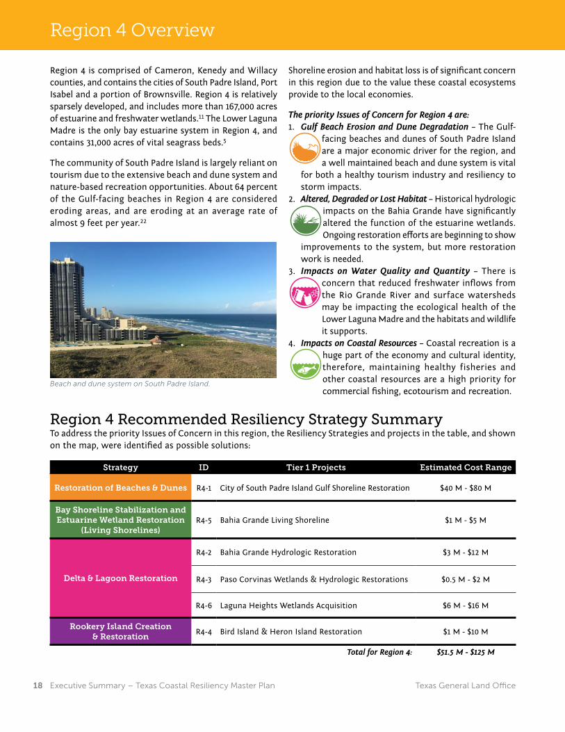
Plan Overview
Region 4 is comprised of Cameron, Kenedy and Willacy counties, and contains the cities of South Padre Island, Port Isabel and a portion of Brownsville. Region 4 is relatively sparsely developed, and includes more than 167,000 acres of estuarine and freshwater wetlands.11 The Lower Laguna Madre is the only bay estuarine system in Region 4, and contains 31,000 acres of vital seagrass beds.5
The community of South Padre Island is largely reliant on tourism due to the extensive beach and dune system and nature-based recreation opportunities. About 64 percent of the Gulf-facing beaches in Region 4 are considered eroding areas, and are eroding at an average rate of almost 9 feet per year.22
Shoreline erosion and habitat loss is of significant concern in this region due to the value these coastal ecosystems provide to the local economies.
The priority Issues of Concern for Region 4 are:1. Gulf Beach Erosion and Dune Degradation – The Gulf-
facing beaches and dunes of South Padre Island are a major economic driver for the region, and a well maintained beach and dune system is vital
for both a healthy tourism industry and resiliency to storm impacts.
2. Altered, Degraded or Lost Habitat – Historical hydrologic impacts on the Bahia Grande have significantly altered the function of the estuarine wetlands. Ongoing restoration efforts are beginning to show
improvements to the system, but more restoration work is needed.
3. Impacts on Water Quality and Quantity – There is concern that reduced freshwater inflows from the Rio Grande River and surface watersheds may be impacting the ecological health of the Lower Laguna Madre and the habitats and wildlife it supports.
4. Impacts on Coastal Resources – Coastal recreation is a huge part of the economy and cultural identity, therefore, maintaining healthy fisheries and other coastal resources are a high priority for commercial fishing, ecotourism and recreation.
Region 4 Recommended Resiliency Strategy SummaryTo address the priority Issues of Concern in this region, the Resiliency Strategies and projects in the table, and shown on the map, were identified as possible solutions:
Strategy ID Tier 1 Projects Estimated Cost Range
Restoration of Beaches & Dunes R4-1 City of South Padre Island Gulf Shoreline Restoration $40 M - $80 M
Bay Shoreline Stabilization and Estuarine Wetland Restoration
(Living Shorelines)R4-5 Bahia Grande Living Shoreline $1 M - $5 M
Delta & Lagoon Restoration
R4-2 Bahia Grande Hydrologic Restoration $3 M - $12 M
R4-3 Paso Corvinas Wetlands & Hydrologic Restorations $0.5 M - $2 M
R4-6 Laguna Heights Wetlands Acquisition $6 M - $16 M
Rookery Island Creation & Restoration
R4-4 Bird Island & Heron Island Restoration $1 M - $10 M
Total for Region 4: $51.5 M - $125 M
Region 4 Overview
Beach and dune system on South Padre Island.

Texas General Land Office 19 Executive Summary – Texas Coastal Resiliency Master Plan
Plan OverviewRegion 4 Counties:Cameron,Kenedy and Willacy
R4-1
KENEDY
CAMERON
WILLACY
KLEBERG
HIDALGO
R4-6
R4-5
R4-4R4-3
R4-2
CAMERON
±
2 1
34
MapExtents
0 20 4010Miles
Resiliency Strategy Project Locations
Rookery Island Creation & Restoration
Delta & Lagoon Restoration
Restoration of Beaches & Dunes
Bay Shoreline Stabilization & EstuarineWetland Restoration (Living Shorelines)

Texas General Land Office20 Executive Summary – Texas Coastal Resiliency Master Plan
Plan Overview
In addition to the projects identified per region, the following coastal programs will address particular Issues of Concern on a coastwide basis. The GLO oversees several coastal programs that do not receive dedicated annual funding to mitigate the Issues of Concern they were created to address.
• Beach Monitoring and Maintenance Program (BMMP) – The BMMP was established to provide ongoing monitoring and maintenance of beaches enhanced through engineering along the Texas coast to maintain Federal Emergency Management Agency (FEMA) funding eligibility. FEMA affirmed that a Beach Monitoring and Maintenance Program is a prerequisite for Texas to receive funding under FEMA’s Public Assistance Program, which provides grants to states for the replacement of sand on engineered public beaches impacted by federally declared disasters, such as tropical storms and hurricanes.
A beach may be considered eligible for disaster assistance funding when: the beach was constructed by the placement of imported sand (of proper grain size) to a designed elevation, width and slope, a maintenance program involving periodic renourishment with imported sand has been established and adhered to by the applicant, and the maintenance program preserves the original beach design.
The GLO, with funding through the Coastal Erosion Planning and Response Act Program, tracks and collects this information to accurately identify the areas impacted and the amount of sand lost during natural disasters. Without a BMMP in place, FEMA has indicated that federal funding, which covers 90 percent of the costs for repairs to these identified areas, will not be approved. A key component of the BMMP, therefore, is the ability to regularly monitor and record engineered beach sand loss.
• Derelict Structure and Vessel Removal Program – The GLO identifies, prioritizes, removes and properly disposes of derelict and abandoned vessels and structures along the entire Texas coastline. Under Texas Natural Resources Code Sections 40.108 (b) and 51.3021, the Land Commissioner has the authority to remove and dispose of derelict vessels and structures abandoned in coastal waters and on state-owned lands.
Currently, there are over 190 vessels coastwide that are in need of removal, and that number continues to grow. The size of derelict and abandoned vessels addressed by this program range from a 12-foot recreational vessel to a 77-foot steel hulled commercial fishing vessel, all the way up to 100-plus foot barges.
The GLO also identified nearly 1,700 abandoned structures in need of removal. Such structures include piers, docks, pilings, debris, duck blinds and floating cabins.
Coastwide Plans, Policies & Programs
Indianola Beach after beach nourishment along Matagorda Bay.
Derelict structures in Corpus Christi Bay.

Texas General Land Office 21 Executive Summary – Texas Coastal Resiliency Master Plan
Plan Overview
Coastwide RecommendationsStrategy Tier 1 Projects Estimated Annual Cost
Plans, Policies and Programs
Beach Monitoring and Maintenance Program $5M per year
Abandoned and Derelict Structure and Vessel Removal Program $3M per year
Abandoned and Derelict Petroleum Production Structure Removal Program $20M per year
Sediment Management Plan $1M per year
• Abandoned Petroleum Production Structure Removal Program –The GLO identifies, prioritizes, removes and properly disposes of abandoned or unauthorized petroleum production structures in coastal waters and on state-owned land. The authority for this program is also found in Texas Natural Resources Code Sections 40.108 (b) and 51.3021.
Approximately 400 abandoned oil and gas wells, and over 170 offshore platforms and associated structures litter the Texas coast. Due to the highly corrosive effects of saltwater and the brute force of tropical storms, abandoned wells and platforms present risks of leaking and causing damage to the state’s natural resources and economic viability. These orphaned wells and platforms can exude toxic pollutants, such as chlorides, hydrocarbons, arsenic, barium, lead and mercury. These contaminants endanger the public health and safety, as well as the plants, fish, shellfish and mammals that all rely on healthy offshore waters, coastal bays, wetlands and estuaries. Abandoned wells and their surrounding structures also pose a navigational hazard for recreational and commercial vessels.
• Sediment Management Plan – Maintenance of Texas ports and navigation channels requires periodic dredging. Finding upland sites for disposal of dredged material is becoming difficult due to competition for space and increasing costs. At the same time, most of the Texas coast is eroding. A holistic approach to sediment management along the sand-starved Texas coast can provide the umbrella for a coordinated and organized process that optimizes use of available sediment sources. Economic benefits will accrue to both maritime transportation interests and those that rely on natural resources and amenities for jobs and income. A sediment management plan for the entire Texas coast is necessary to allow for coastwide coordination in sediment resources. The ultimate goal is a full-fledged program to coordinate the beneficial use of dredged material with the U.S. Army Corps of Engineers and other identified partners.
Abandoned petroleum structure on Bolivar Peninsula. Deck barge transporting sand along the GIWW.

Texas General Land Office22 Executive Summary – Texas Coastal Resiliency Master Plan
Plan Overview
Restoration of Beaches and DunesThe beaches and dunes along Texas barrier islands are highly dynamic systems that provide a first line of defense for coastal communities and infrastructure against the impacts from hurricanes, tropical storms and coastal flooding. Texas Gulf and bay beaches are strong drivers of economic activity throughout the coastal zone by providing sought after tourist destinations and recreational opportunities, as well as valuable habitat for wildlife, such as sea turtles and shorebirds. Shoreline erosion is an ongoing natural process; however it is exacerbated by coastal Pressures, such as sea level rise, storms, sediment deficits and development, necessitating the need for beach and dune restoration.
This Resiliency Strategy provides an approach for the restoration and protection of bay beaches and Gulf-facing beaches and dunes, and identifies potential methods and engineered solutions, such as groins, where appropriate, to help improve sediment retention in the beach and dune systems. The projects within this Strategy are selected based on available sediment, areas of critical erosion, and feasibility of project funding and construction.
Eroded beach
Rebuilt beach
Beach nourishmentand dune restoration
Vegetation plantedto trap sand and control erosion
Restoration of Beaches & DunesGroin: A rigid structure built out from a shore to protect the shoreline from erosion by trapping sand or to redirect a current from scouring a channel.
Dune: A mound or ridge formed from sand that is deposited by the wind. Dune systems provide important protection to the mainland from storm surge.
Strategy Project Type Examples
Selected Strategies to Achieve a Resilient Texas CoastThe Texas Coastal Resiliency Master Plan identifies various types of nature-based projects within the Resiliency Strategies to address the Issues of Concern and to help achieve a resilient coast. The following pages describe examples of the project types, and the benefits to coastal systems, that may be implemented to achieve the goals of the Resiliency Strategies and address the Issues of Concern.
Groin off Galveston Beach.

Texas General Land Office 23 Executive Summary – Texas Coastal Resiliency Master Plan
Plan Overview
End of the Seawall Beach and Dune Nourishment Project from start to finish in Galveston.
Planted dune grass and fencing to trap sand and rebuild the dune.
Beach nourishment is the placement of sand onto an eroding shoreline to create a new beach or to widen the existing beach. Sand used for beach nourishment is transported by truck from inland sources, is sourced from maintenance dredging of nearby channels or harbors, known as Beneficial Use of Dredged Material, or is pumped or barged from offshore sand deposits. Once a beach is nourished it must be periodically renourished to maintain a stable shoreline. Local erosion rates and the availability of economical sand sources are important factors in feasibility, location and extent of beach nourishment projects. Beach nourishment is often accompanied by dune restoration.
Dune restoration is the process of repairing or restoring dunes along the Gulf beach damaged by human activity, ongoing erosion or storms. Methods of dune restoration vary widely, and the suitable method in a particular location will be determined based on the reason for restoration, urgency of need, feasibility and budgetary considerations. The planting of dune vegetation (dune grass) is a component of restoration and is a relatively low-cost method to stabilize a dune. When planted in the appropriate location and density along the dune, wind-blown sand is trapped by the vegetation, allowing the dune to gradually build. The placement of sand fences acts in a similar way to trap sand and encourage the development of a more stable dune complex. Dunes may also be built by more mechanical means such as transporting sand from upland sources or placing dredged material on the dunes.
BeforeBeach and Dune Nourishment
During
After

Texas General Land Office24 Executive Summary – Texas Coastal Resiliency Master Plan
Plan Overview
Bay Shoreline Stabilization &Estuarine Wetland Restoration
Eroded marshshoreline
New marsh
Bu�er constructed to dissipate wave energy and reduce erosion
for marsh regeneration
Calm shallow waters to provide aquatic habitat
Wetlands
Marsh grass planting to trap sediment and build
marsh habitat
Bay Shoreline Stabilization and Estuarine Wetland Restoration (Living Shorelines)This Resiliency Strategy identifies areas of bay shoreline that have experienced significant land loss and deterioration, and proposes solutions to stabilize and rebuild these critical shoreline areas. This Strategy proposes potential locations that will benefit from installation of living shorelines and/or breakwaters to mitigate existing impacts from erosion and provide for future protection.
Living shorelines are shoreline stabilization measures that incorporate nature-based solutions to fully or partially reduce erosive forces along the shoreline to protect property and critical estuarine wetland habitat. Restoration or enhancement of vegetated shoreline areas is achieved through strategic placement of a variety of structural and organic material, such as wetland plants, submerged aquatic vegetation, oyster reefs, geotextile tubes, sand fill and stone.7 These structures act as wave breaks by reducing wave energy and support wetland habitat creation. In addition, living shorelines provide improved water quality and clarity, and natural landscape aesthetics. In many cases, the living shorelines approach to shoreline stabilization is preferable to the use of hardened structures, such as bulkheads or seawalls, which can interrupt the natural processes of sediment movement throughout the nearshore system, may negatively impact wildlife habitat, and can ultimately increase rates of coastal erosion. In areas where erosion control structures, like bulkheads, are failing, living shorelines may be installed in front of the bulkhead to build wetlands and stabilize the shoreline.
Wetlands: Naturally occurring or restored lands, such as marshes, swamps or tidal flats, that are covered often intermittently with shallow water or have water saturated soil.
Marsh: A wetland dominated by soft-stemmed vegetation, such as grasses or shrubs, specially adapted to saturated soil conditions.
Geotextile Tubes: A tube-shaped erosion-control device constructed from woven geotextile (a highly durable, permeable and flexible material) filled with dredge material.
Bulkhead erosion along Trinity Bay
Successful living shoreline after installation in front of bulkhead.
Strategy Project Type Examples

Texas General Land Office 25 Executive Summary – Texas Coastal Resiliency Master Plan
Plan Overview
Stabilizing the Texas Gulf Intracoastal Waterway (GIWW)The Gulf Intracoastal Waterway is a key navigation channel that was built to provide inland waterway transportation and commerce. The GIWW is also used for recreational boating and commercial and recreational fishing.
Vessel traffic within the GIWW creates strong wakes that contribute to high rates of shoreline erosion and wetland loss along the channel and dredged material placement islands that line the GIWW. The wetlands adjacent to the GIWW provide shoreline protection for inland habitats preventing saltwater intrusion into the freshwater wetlands and lakes.
As the shorelines and wetlands erode, they become further exposed to wave action that contributes to the silting in of the GIWW and necessitates more frequent and costly channel dredging and maintenance. Addressing shoreline loss is an important component of efforts to maintain and enhance the economic benefits of the GIWW while mitigating environmental impacts associated with its operation.
This Resiliency Strategy identifies areas along the GIWW with the greatest need for shoreline protection for adjacent wetlands and dredge material placement islands. A living shoreline approach or other shoreline stabilization methods along the channel and placement islands can be implemented to mitigate the erosion.
Shoreline stabilization of the dredged material placement islands provides critical colonial waterbird nesting habitat, as well as protection for adjacent habitats along the GIWW, such as fringe marshes and seagrass beds that are vital to the bay ecosystems and promote habitat resiliency. In addition, shoreline stabilization reduces channel siltation and the placement islands serve to buffer the GIWW from wave action, benefiting vessel traffic by improving navigability and maneuvering along the channel.
Eroding marshShorelinearmoring
StablemarshWake
After StabilizationBefore Stabilization
Wake
E�ect of boats and barges on theGulf Intracoastal Waterway
Stabilizing the Texas GIWW
Shoreline armoring along the GIWW.
Close-up of shoreline armoring along the GIWW.

Texas General Land Office26 Executive Summary – Texas Coastal Resiliency Master Plan
Plan Overview
Freshwater Wetlands and Coastal Uplands ConservationThis Resiliency Strategy identifies freshwater wetlands and coastal uplands that will benefit from restoration, conservation or enhancement. Solutions may involve expanding or restoring existing coastal protected areas, such as National Wildlife Refuges and Wildlife Management Areas, through property acquisitions or conservation easements. Other projects considered under this Strategy include restoring local water flow (hydrologic restoration) to wetland areas with techniques such as the installation of siphons, channel reconfiguration and land conservation planning. Wetland restoration can also be designed to improve watershed drainage.
Freshwater wetlands are areas that receive enough water to support grasses, such as cattails and bulrushes, or trees, such as cypress, with root systems that are often flooded with fresh water. Freshwater wetland ecosystems are present in the coastal uplands that border the bays of the Texas coast and are typically found along stream banks, lakes or in low-lying areas that receive frequent flooding.
Coastal uplands are areas, including grasslands and woodlands, that are not typically inundated with water and are elevated above floodplain levels, allowing the land to remain relatively dry.
These wetlands and upland areas provide a critical benefit to the environment by serving as filters for urban stormwater runoff prior to entering aquifers, streams or lakes. These areas also perform as detention zones that collect and slowly release flood waters to mitigate coastal flood damage and provide important habitat for many species of birds and other wildlife.
Wildlifehabitat
Urbanruno�
Collects and filters contaminants from stormwaterFreshwater
Wetlands
Coastal Uplands
Clean water
Groundwater
Freshwater Wetlands & Coastal Uplands Conservation
Runoff: The draining away of water and substances carried in it from the surface of an area of land, a building or structure.
Siphons: A tube used to convey liquid upwards from a reservoir and then down to a lower level of its own accord. Once the liquid has been conveyed into the tube, typically by suction or immersion, flow continues unaided.
Watershed: A land area where water entering it is drained by flow toward a common outlet distinct from adjacent areas.
Hydrologic Restoration: The process of restoring natural drainage patterns to remedy altered hydrology and improve the movement, distribution and quality of water. The methods used are intended to reverse the complete or partial blockage of water flow by barriers such as levees, dikes and causeways to restore the health of the wetlands.13
Strategy Project Type Examples
Installed siphons in Matagorda Island National Wildlife Refuge to restore water flow to wetland areas.

Texas General Land Office 27 Executive Summary – Texas Coastal Resiliency Master Plan
Plan Overview
Delta and Lagoon RestorationIn several watersheds along the coast, inland development and construction of dams, levees, navigation channels and other water control features has diverted or reduced the water flowing from rivers into coastal deltas. Disruptions to the hydrology of natural river flow can cause a reduction in freshwater inflows carrying the necessary sediment, mineral and nutrient deposits to its delta, and associated lagoons, which characterize a healthy deltaic ecosystem. Sediments help build and maintain bay shorelines, mud flats and other shallow water habitat features, and nutrient and freshwater inflows maintain the proper salinity and nutrient balances vital to the health of aquatic life.
When delta or lagoon hydrology is disturbed, cascading impacts on the system can occur. The reduction of freshwater inflows can significantly increase the salinity of an estuarine system, impacting freshwater marshes and wetlands. The reduction of sediment can lead to widespread erosion throughout the bay, and an imbalance in estuarine nutrients can lead to harmful algal blooms, decreased water quality and other negative environmental and public health impacts. In addition, during storm events rivers can convey heavy influxes of stormwater and wastewater carrying pollution into the delta, which alters salinity levels and further impairs water quality.
This Resiliency Strategy identifies specific delta and lagoon systems that have the greatest need for hydrologic restoration. Approaches to address the reduction of freshwater inflows may include smart land-use planning to protect critical coastal habitats and watershed areas that provide storage and filtration of storm water runoff, restoring freshwater inflows with land contouring or installed infrastructure (such as siphons), and terracing designed to restore drainage.
Decreased freshwater flow degrades habitats and water quality downstream.
Improved freshwater flow increases habitat resiliency and water quality.
Delta & Lagoon Restoration
Before After
Deltas: Accumulation of sediment that is deposited at the mouth of a river rather than being washed away by currents or ocean waves. Over time, a complex of channels, sand bars and marshes may form.
Lagoons: Protected areas of calm water between the coast and the barrier beaches or islands that receive little fresh water input. The Laguna Madre is the only hypersaline lagoon (a body of water saltier than most seawater) in the United States.
Estuary: Semi-enclosed coastal body of water that has a connection to the saline waters of the open ocean and fresh water from rivers and streams.
Nueces River Delta.

Texas General Land Office28 Executive Summary – Texas Coastal Resiliency Master Plan
Plan Overview
BeforeRestoration
AfterRestoration
2 Years AfterRestoration
Oyster shell cultch provides an anchorfor juvenile oysters
Oyster reefrecruitment
Oyster Reef Creation & Restoration
Oyster Reef Creation and RestorationOysters are critical to the health of bay systems, due to their roles in maintaining water quality and biodiversity by filtering water and building structural habitat within an ecosystem. Oyster reefs stabilize shorelines, prevent erosion and act as a buffer against wave action from hurricanes and tropical storms.
Some oyster reef restoration techniques include:• Distributing large amounts of shell into the water with high pressure
hoses to provide cultch, or bedding areas, for larval oysters to attach to and grow;
• Constructing a linear reef of discarded oyster shell and rock to stabilize the shoreline while protecting seagrass plantings behind the reef (a type of living shoreline); and
• Collecting and bagging recycled oyster shell for re-use to establish new oyster reefs.14
This Resiliency Strategy focuses on restoring oyster reefs in the bay systems that are ecologically best suited to sustain them. The restoration efforts include studying, collaborating and researching the optimal locations and scale for oyster restoration projects within the identified bay systems to most effectively apply this Strategy.
Cultch: Shell, limestone, rubble or other hard material that provides habitat for oyster colonization.
Strategy Project Type Examples
Volunteers place bagged shell in bay to rebuild reef.
Bagged recycled oyster shell.

Texas General Land Office 29 Executive Summary – Texas Coastal Resiliency Master Plan
Plan Overview
Bird nesting habitatprotected from predatorsand human disturbance
Installed erosionprotection measure
Calm watersfor foraging
Dredge materialplacement
and plantings
Rookery Island Creation & Restoration
Rookery Island Creation and RestorationRookery islands are typically quite small – only a few acres or less – and while some naturally exist, most were formed from the placement of dredged material during the creation or maintenance of nearby navigation channels, like the GIWW, or channels and basins supporting ports and marinas. Rookeries are ideal nesting, breeding and rearing areas for a wide variety of colonial waterbirds and coastal shorebirds because they are isolated from the mainland and are too small to sustain populations of predators. Birds that form colonies include various species of pelicans, egrets, terns, herons, ibis and the roseate spoonbill. A fully functioning, contiguous rookery island system along the whole Gulf Coast is necessary to support migratory birds during the critical migration seasons.
This Resiliency Strategy considers how rookery islands function as a contingent, coastwide system and proposes a blueprint to ensure that a continuous chain of rookery islands exists along the entire Texas coast to allow bird populations to nest, migrate and flourish. This Strategy also identifies existing rookery islands in need of restoration and proposes locations for the creation of additional rookery habitats. In conjunction with ongoing sediment management planning efforts, sediment sources may be identified for beneficial use in constructing or restoring rookery islands. To promote long-term stability for the islands, rookery island restoration solutions may need to work in tandem with living shoreline approaches, and wetland and oyster reef restoration initiatives.
Shamrock Island in Corpus Christi Bay.
Birds on rookery island.

Texas General Land Office30 Executive Summary – Texas Coastal Resiliency Master Plan
Plan Overview
Shoring Up the Future for the Texas CoastThe Texas coast is home to millions of people, irreplaceable natural resources and vital industries. Yet despite years of warnings underscored by catastrophic storms such as Hurricane Ike and Hurricane Dolly, our Texas coastline remains disturbingly vulnerable.
Shoreline erosion along the Texas coast is, and will continue to be, a significant long-term issue impacting the entire state if mitigation projects are not implemented. Some areas along the Texas Gulf Coast experience an average annual erosion rate in excess of 30 feet.22 In addition to erosion, the negative impacts from altered, degraded or lost habitat and impacts on water quality and quantity, illustrate the need for the state to institute solutions to combat these devastating problems.
Simply put, a strong coast means a strong Texas. Currently 6.5 million people live along Texas shores, with projections expected to reach more than 9 million by 2050.18 The critical infrastructure and industry along our coast
anchors the state and national economies. The Texas coast helps bestow millions of jobs and produces tens of billions of dollars in goods and services that impact our daily lives.
Texans and visitors should be able to enjoy a relaxing day at the beach or fishing in a bay. The industries that drive our economy should be able to rely on roads and waterways that are safe and efficient. And we should all seek the peace of mind that comes with adequate preparation for the types of storms and other disasters that have happened before and are sure to strike again.
Our coast faces many threats that must be addressed. Meeting these challenges will not be easy, but it can be done. The ongoing development of the Texas Coastal Resiliency Master Plan will continue to identify and update the Issues of Concern that affect the resiliency of the coast, and will provide solutions to benefit all Texans for generations to come.
“Millions of Texans live and work along the coast and the time has come to get serious about investing in its protection. By working together, we will directly address ongoing threats to the Texas coast and ensure a safer,
more protected region for future generations.”George P. Bush,
Commissioner, Texas General Land Office
Shoring Up Our Future
Aransas Bay at Rockport.

Texas General Land Office 31 Executive Summary – Texas Coastal Resiliency Master Plan
Plan Overview
1. Bureau of Economic Analysis. 2014. “Regional Data: Real GDP by State (millions of chained 2009 dollars), Texas.” Available at: https://bea.gov/iTable/index_regional.cfm (accessed Sept 30, 2016)
2. Douglass, Elizabeth. 2008. “U.S. pump prices surge in Ike’s wake.” Los Angeles Times. Available at: http://articles.latimes.com/2008/sep/15/business/fi-oilstorm15 (accessed Feb 2, 2017)
3. “Energy Industry Overview.” Greater Houston Partnership. 2016. Available at: http://www.houston.org/newgen/16_Industry_NEC/16B%20W010%20Energy%20Industry%20Overview.pdf (accessed Aug 16, 2016).
4. Federal Emergency Management Agency (FEMA). 2008. Hurricane Ike Impact Report. Available at: https://www.fema.gov/pdf/hazard/hurricane/2008/ike/impact_report.pdf (accessed Feb 2, 2017)
5. Finkbeiner, M. J., J. D. Simons, C. Robinson, et. al. 2009. “Atlas of shallow-water benthic habitats of coastal Texas : Espiritu Santo Bay to Lower Laguna Madre, 2004 and 2007.” NOAA Coastal Services Center, Charleston.
6. Freedman, Andrew. 2012. “Top 5 Most Vulnerable U.S. Cities to Hurricanes.” Climate Central. Available at: http://www.climatecentral.org/news/top-5-most-vulnerable-us-cities-to-hurricanes (accessed Feb 2, 2017)
7. Galveston Bay Foundation. 2017. “Living Shorelines.” Available at: http://galvbay.org/how-we-protect-the-bay/on-the-ground/living-shorelines/ (accessed Feb 2, 2017)
8. Koumoudis, V., C. Jones, L. Tanner, and W. Wilson. 2009. Mitigation Assessment Team Report: Hurricane Ike in Texas and Louisiana. Federal Emergency Management Agency. Available at: https://www.fema.gov/media-library-data/20130726-1648-20490-1790/757_ch1_final.pdf (accessed Feb 2, 2017)
9. Morton, R. A. 1979. “Temporal and spatial variations in shoreline changes and their implications, examples from the Texas Gulf coast.” Journal of Sedimentary Petrology, 49(4): 1101 – 1112.
10. National Oceanic and Atmospheric Administration (NOAA). 2016. “Abandoned and Derelict Vessels.” Available at: http://response.restoration.noaa.gov/oil-and-chemical-spills/oil-spills/abandoned-and-derelict-vessels.html (accessed Nov 30, 2016)
11. National Oceanic and Atmospheric Administration (NOAA). 2011. “Land Cover Atlas.” Climate Change Analysis Program (C-CAP).
12. National Oceanic and Atmospheric Administration (NOAA). 2017. “Barrier Islands—Habitat of the Month.” NOAA Habitat Conservation, National Marine Fisheries Service. Available at: http://www.habitat.noaa.gov/abouthabitat/barrierislands.html (accessed Feb 2, 2017)
13. National Oceanic and Atmospheric Administration (NOAA). 2017. “Hydrologic Reconnection.” NOAA Habitat Conservation, National Marine Fisheries Service. Available at: http://www.habitat.noaa.gov/restoration/approaches/hydrologicrestoration.html (accessed Feb 2, 2017)
14. National Oceanic and Atmospheric Administration (NOAA). 2017. “Oyster Restoration.” NOAA Habitat Conservation, National Marine Fisheries Service. Available at: http://www.habitat.noaa.gov/restoration/techniques/oysterrestoration.html (accessed Feb 2, 2017)
15. National Waterways Foundation. 2012. “A Modal Comparison of Domestic Freight Transportation Effects on the General
Public: 2001-2009.” Texas Transportation Institute, Texas A&M University. Available at: http://nationalwaterwaysfoundation.org/study/FinalReportTTI.pdf (accessed Feb 2, 2017)
16. Paine, J. G., T. Caudle, and J. Andrews. 2014. “Shoreline Movement along the Texas Gulf Coast, 1930’s to 2012.” Final Report to the Texas General Land Office, Bureau of Economic Geology, The University of Texas at Austin.
17. Texas Administrative Code. 2014. 31 TAC §15.2(a). “General Land Office, Coastal Area Planning.” Available at: http://www.sos.texas.gov/tac/index.shtml (accessed Feb 3, 2017)
18. Texas State Data Center. 2014. “Projections of the Population of Texas and Counties in Texas by Age, Sex and Race/Ethnicity for 2010-2050.” Office of the State Demographer.
19. Texas Water Development Board (TWDB). 2016. Bays and Estuaries. Available at: https://www.twdb.texas.gov/surfacewater/bays/index.asp (accessed Jan 13, 2016)
20. Tourism Economics. 2015. “The Economic Impact of Tourism on Galveston Island, Texas.” Prepared for the Convention & Visitors Bureau, Galveston Island Park Board. Available at: http://www.galvestonparkboard.org/ArchiveCenter/ViewFile/Item/53 (accessed Feb 2, 2017)
21. Townsend, K., et al. 2014. “Reducing Shoaling in the Texas GIWW and Erosion of Barrier Islands along West Galveston Bay.” Terra et Aqua. Available at: https://www.iadc-dredging.com/ul/cms/terraetaqua/document/4/1/9/419/419/1/article-reducing-shoaling-in-the-texas-giww-and-erosion-of-barrier-islands-along-west-galveston-bay-terra-et-aqua-136.pdf (accessed Dec 29, 2016)
22. University of Texas at Austin, Bureau of Economic Geology (2014). Shoreline Change Rates 1950’s-2012. Retrieved from http://www.arcgis.com/home/item.html?id=7bd9c5bf9823451bb783ce22f18cecc9 January 30, 2017 and described in Paine, J. G., Caudle, T., & Andrews, J. (2014). Shoreline Movement along the Texas Gulf Coast, 1930’s to 2012. Final Report to the Texas General Land Office, Bureau of Economic Geology, University of Texas, Austin.
23. U.S. Army Corps of Engineers (USACE). 2016. “U.S. Waterway Data, Principal Ports of the U.S., 2015. Navigation Data Center.” Available at: http://www.navigationdatacenter.us/data/datappor.htm (accessed Jan 18, 2017)
24. U.S. Department of Energy. 2017. “SPR Quick Facts and FAQs: Crude Oil Storage by Site.” Available at: https://energy.gov/fe/services/petroleum-reserves/strategic-petroleum-reserve/spr-quick-facts-and-faqs (accessed Feb 2, 2017)
25. U.S. Department of Transportation. 2014. “Tonnage of Top 50 U.S. Water Ports, Ranked by Total Tons (Table 1-57). Bureau of National Transportation Statistics.” Available at: http://www.rita.dot.gov/bts/sites/rita.dot.gov.bts/files/publications/national_transportation_statistics/html/table_01_57.html (accessed Sept 19, 2016)
26. U.S. Energy Information Administration. 2016. Petroleum & Other Liquids, Refinery Capacity Report. Available at: http://www.eia.gov/petroleum/refinerycapacity/ (accessed Feb 2, 2017)
Photo Credits• Page 27 – Harte Research Institute for Gulf of Mexico Studies• Page 28 – Texas A&M University Corpus Christi• Page 29 – The Nature Conservancy
References

Texas General Land Office32 Executive Summary – Texas Coastal Resiliency Master Plan
Plan Overview
Texas Coastal CMYK ver 1.0
A publication of the Texas General Land Office. Funded by a grant from the U.S. Department of Commerce, National Oceanic and Atmospheric Administration pursuant to award No. NA15NOS4190162.Published March 2017.