Test Interview Geology
61
r.A.Farooqui 1 GENERAL GEOLOGY 1. Importants Part of Earth Interior: Based on chemical properties Depth km Based on physical properties Depth km Crust 40 Lithosphere (cool, rigid) 100 Asthenosphere (hot, plastic) 350 Mantle 2883 Mesosphere (hot but strong due to high pressure) 2883 Outer Core Liquid Outer Core (Liquid NiFe) Inner Core 6370 Solid Inner Core ( Solid NiFe) 6370 2. Major Features of the Earth: • Shield Areas • Stable Platforms • Folded Mountains • Ocean Floor a. The Oceanic Ridge b. The Abyssal Floor c. Seamounts or Volcanic Mounts d. Trenches e. Continental Margins 3. Percentage of the most abundant Element in Earth: Elements Symbol Percentage Oxygen O 46.60 Silicon Si 27.72 Aluminum Al 8.13 Iron Fe 5.00 Calcium Ca 3.63 Sodium Na 2.83 Potassium K 2.59 Magnesium Mg 2.09 Titanium Ti 0.44 Hydrogen H 0.14 Phosphorous P 0.12 Manganese Mn 0.10 Sulfur S 0.05 Carbon C 0.03 4. Mohos Scale of Hardness: Hardness Mineral Scratched ability 1 Talc 2 Gypsum Scratched by a Finger Nail 3 Calcite 4 Fluorite Scratched by a Copper Coin 5 Apatite Scratched by a Knife 6 Feldspar Scratched by a Glass 7 Quartz 8 Topaz 9 Corundum Steel File 10 Diamond No Scratched
-
Upload
sikander-mushtaq -
Category
Documents
-
view
228 -
download
0
Transcript of Test Interview Geology
8/13/2019 Test Interview Geology
http://slidepdf.com/reader/full/test-interview-geology 1/61r.A.Farooqui
GENERAL GEOLOGY
1. Importants Part of Earth Interior:
Based on chemical propertiesDepth
kmBased on physical properties
Depth
km
Crust 40 Lithosphere (cool, rigid) 100
Asthenosphere (hot, plastic) 350Mantle 2883 Mesosphere (hot but strong due
to high pressure)2883
Outer Core Liquid Outer Core (Liquid NiFe)
Inner Core 6370 Solid Inner Core ( Solid NiFe) 6370
2. Major Features of the Earth:
• Shield Areas
• Stable Platforms
• Folded Mountains
• Ocean Floor
a. The Oceanic Ridge b. The Abyssal Floorc. Seamounts or Volcanic Mountsd. Trenches
e. Continental Margins
3. Percentage of the most abundant Element in Earth:
Elements Symbol Percentage
Oxygen O 46.60
Silicon Si 27.72
Aluminum Al 8.13
Iron Fe 5.00
Calcium Ca 3.63
Sodium Na 2.83
Potassium K 2.59
Magnesium Mg 2.09Titanium Ti 0.44
Hydrogen H 0.14
Phosphorous P 0.12
Manganese Mn 0.10
Sulfur S 0.05
Carbon C 0.03
4. Mohos Scale of Hardness:
Hardness Mineral Scratched ability
1 Talc
2 GypsumScratched by a Finger Nail
3 Calcite
4 FluoriteScratched by a Copper Coin
5 Apatite Scratched by a Knife
6 Feldspar Scratched by a Glass
7 Quartz
8 Topaz
9 Corundum
Steel File
10 Diamond No Scratched

8/13/2019 Test Interview Geology
http://slidepdf.com/reader/full/test-interview-geology 2/61r.A.Farooqui
5. Rock forming Mineral:
S.No Mineral Groups Mineral
1 Oxides Quartz, Hematite.
2 Carbonates Calcite, Dolomite, Magnesite, Ankarite.
3 Sulfides Pyrite, Galena
4 Sulfates Gypsum, Anhydrite, Hexahydrite, Polyhalite.
5 Chlorites Rock Salt, Sylvite, Bischoffite, Carnallite.
6 Silicates Feldspars, Mica, Hornblende, Augite, Olivine
6. Crystal System:System Axes Mineral Example
Isometric 3 axes, at 90 Garnet, Fluorite, Pyrite, Sphalerite, Halite
Tetragonal 3 axes at 90, 2 hori = but 2 ver is short or long Zircon, Cassiterite
Hexagonal 4 axes, 3 = hori axes at 60, 1 axes vertical s l Qurtz, Apatite, Calcite, Beryl
Orthorhombic 3 axes of differ length at 90 Olivine, Topaz
Monoclinic 3 unequal axes, 2 axes at 90 3 is inclined Orthoclase, Mica, Augite, Gypsum
Triclinic 3 unequal axes, none at 90 Plagioclase, Axinite
7. Geological Time Scale:
Era Eon Periods EpochWell Known
Names
Developments of Plants
and animals
Duration
in Ma
M
aHolocene Human age Human 0
QuaternaryPleistocene Ice age Modern Plants 1.6 1
Pliocene 3.7 5 Neogene
Miocene Mammals 18.4 2
Oligocene 12.9 3
Eocene Mollusks 21.2 5 C
e n o z o i c
T
e r t i a r y
Paleogene
Paleocene
Age ofMammals
Extinction of 8.6 6
Cretaceous 1st Flowering Plant 78 1
Jurassic First Bird 64 2
M
e s o z o i c
Triassic
Dinosaursand other
species Age of
Reptiles
Dinosaurs dominant Extinction of 37 2
Permian Trilobites 41 28
Pennsylvanian 1st Reptiles 34 3Carboniferous
Mississipian
Age ofAmphibians Large Coal swamps and
amphibians abundunt40 3
Devonian 1st Insect fossils 48 4
SilurianAge of Fishes 1st Land Plants and Fishes
dominant30 4
Ordovician 1st Fishes 67 5
P h a n e r
o z o i c
P
a l e o z o i c
Cambrian
Age ofInvertebrates
1st organisms with shellsand Trilobites dominant
65 5
Late 1st Multi celled Organisms 330 9
Middle 700 16
P
r o t e r o z o i c
Early 900 25
Late 1st One celled organism 500 30
Middle 400 34
A
r c h e a n
Early Age of Oldest Rock 400 38 P r e c a m
b r i a n
Haden Origin of Earth 1200+ 46
8/13/2019 Test Interview Geology
http://slidepdf.com/reader/full/test-interview-geology 3/61r.A.Farooqui
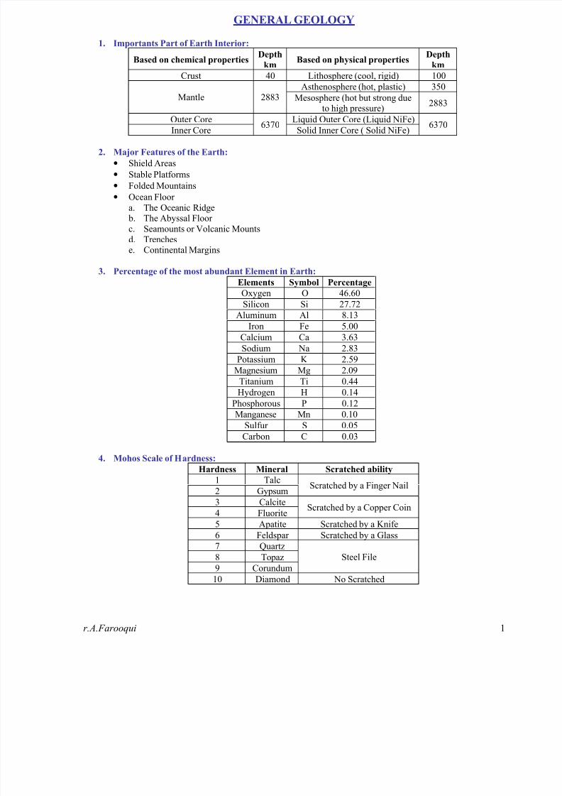
8. Rock Cycle:
The image shows how rocks are created and destroyed as part of a process called the “rock cycle”. All threetypes of rocks – igneous, sedimentary, and metamorphic – are created and destroyed as part of the earth’svarious processes.
Pix show Energy reaches earth from an external
source eventually returns to space as heat radiation.
Smaller System within earth the atmosphere,
biosphere, hydrosphere, and geosphere – are all
open systems.
The rock cycle traces the processes whereby
materials within and on top of earth’s crust are
weathered, transported deposited, metamorphosed
and even melted.

8/13/2019 Test Interview Geology
http://slidepdf.com/reader/full/test-interview-geology 4/61r.A.Farooqui
9. Igneous Rock:
Bowen Reaction Series:
High Temperature Olivine Calcic Feldspar
(Early)Pyroxene
AmphiboleSodic Feldspar
Biotite
Potassium Feldspar
Muscovite(Late)
Low Temperature Quartz
Igneous Rock Classification:
“On the Basis of Silica Content”
Acidic
Si >65%Light
Intermediate
Si 65-55%
MediumSub Acidic Sub Basic
Basic
Si 55-45%Dark
Ultrabasic
Si <45%V.Dark
Granodiorite Syenite Diorite Gabbro Peridotite
Granite Dunite
P L
U
T
O
N
I C
Pyroxenite
Andulite Monzonite TrachysiteSyeno
Gabbro
Pegmatite
GranitePorphry
Syenite
Porphry
Diorite
Porphry Dolerite
H
Y
P A B
Y
S S A
L
TrachyBasalt
Rhyolite TrachyteAlkaliGabbro
ObsidianAlkaliBasalt
“ O
n t
h e
B
a s i s
o f
T
e x t u r e
a n d m
o d e
o f o c c u r r e n c e ”
V
O
L
C
A
N
I C
Pitchstone
Andesite
Basalt
Min
Comp
Quartz
Orthoclase
Orthoclase
>+-Plagio
Plagio >+-
Orthoclase
Plagio
+Augite
Olivine
PyroxeneOccurrence:
Sill => intrusive body parallel to strataDyke => intrusive body perpendicular to strataBatholith => Large magmatic basinLapolith => Funnel shapeLaccolith => Umberalla shape (plano-convex)Phacolith => crests and trough under folded strataStock => small batholithBoss => Circular shapeVolcanic Neck or Plug => plug type intrusive bodyLawa flows

8/13/2019 Test Interview Geology
http://slidepdf.com/reader/full/test-interview-geology 5/61r.A.Farooqui
10. Metamorphic Rock:
Agents of Metamorphism:
• Temperature
• Pressure
• Chemical Fluids
Types of Metamorphism:
• Thermal Metamorphism
• Dynamothermal Metamorphism (Regional Metamorphism)
• Cataclastic Metamorphism
• Plutonic Metamorphism
• Metasomatism
Zones of Metamorphism:
Metamorphic
ZonesTemperature Pressure
Metamorphism
TypesExample
Epizone orUpper Zone
Low (300) High dp Cataclastic Phyllites
Mesozone orIntermediate Zone
300 – 500 High dp Dynamothermal Schists
Katazone orLower Zone
500 – 800+ High up Plutonic Gneiss
Structures of Metamorphic Rocks:• Schistose Structure
• Gneissose Structure
• Granulose Structure
• Slaty Structure
11. Sedimentary Rocks:
Terminologies of grains:
Sorting Shapes Sphericity Angularity Roundness Transporting Agency
Very well sorted
Well sortedModerately sorted
Poorly sortedVery poorly sorted
EquantRod likeTabular
Discoidal
High
Low
Very AngularAngular
Sab Angular
Sub roundedRounded
Well rounded
Glacier => Glacial depositeWater =>River = Alluvial depositesLakes = Lacustrine deposite
Sea = Marine depositesWind => Aeolian/ Eoliandeposites.
Classification of Sedimentary Rocks:
Rudaceous Rocks Boulder deposit e.g,Conglomerate
Arenaceous Rocks Sandy Rocks e.g,Sandstone
Mechanically Formed (based on physical behaviour)
ArgillaceousRocks
Clayey Rocks e.g,Shale
Calcarious Rocks Limestone C
l a s t i c
R
o c k s
Organically Formed (due toaccumulation animals and plant
remains)CarbonaceousRocks
Coal Seams
Carbonate Rocks Limestone, Dolostone
Sulfate Rocks Gypsum rock
N
o n C
l a s t i c
R
o c k s Chemically Formed (due to
precipitation accumulation ofsoluble constituents) Chlorite Rocks Rock Salt

8/13/2019 Test Interview Geology
http://slidepdf.com/reader/full/test-interview-geology 6/61r.A.Farooqui
Wentworth Scale of Grain:
Size
F
Size
mmGrain size names
Rock
groupRock name Texture
>256 Boulders
-8 256 Cobbles
-6 64 Pebbles
-2 4 Granules G
r a v e l
Cnglemerate,Breccia
Epiclastic ruditic
-1 2 Very Coarse Sand
0 1 Coarse Sand
1 1/2 Medium Sand
2 1/4 Fine Sand3 1/8 Very Fine Sand
S
a n d
Sandstone (Arenite,
Wacke)
Epiclastic arenitic
4 1/16 Silt
8 1/256 ClayMud
Siltstone, Shale,Mudstone, Claystone
Epiclastic lutitic
Dunhan’s (1962) Classification of Carbonate:
On the basis of texture and grains mud ratio
Terms
Predominantly
calcite
Cc>95%
Dominatly
Clalcite
95%>Cc<50%
Dominantly
Dolomite
Do>50%
Mudstone
<10% grainLime Mudstone
DolomiticLime
Mudstone
DolomudstoneMud
SupportedWackstone
>10% grainWackstone
Dolomitic
WackstoneDolowackstone
C
o n t a i n s
M
u d
Packstone
>10% MudPackstone
DolomiticPackstone
Dolopackstone
Lacks
Mud
Grain
Supported Grainstone
<10% MudGrainstone
Dolomitic
GrainstoneDolograinstone
D
e p o s i t i o n a l t e x t u
r e
r e c o g n i z e a b l e
Originally Compounds bound together
Boundstone BoundstoneDolomitic
BoundstoneDoloboundstone
Depositional texture not
recognizeable
Crystalline
Carbonate
Crystalline
Limestone
Dolomitic
Limestone
Crystalline
Dolostone
Weathering Products of Common Minerals:
CommonMinerals in
Rocks Weathering Products
Quartz Quartz, dissolved Silica
Feldspars Clays; Ca, Na, K ions; dissolved Silica
White Micas Clays; Ca, Na, K ions; dissolved Silica; Gibbsite
Biotite Clays; iron oxides; K, Mg, Fe ions; dissolved Silica
Amphiboles Clays; iron oxides; Ca, Na, Mg, Fe ions; dissolved Silica
Pyroxene Clays; iron oxides; Ca, Mn, Mg, Fe ions; dissolved Silica
Olivine Clays; iron oxides; Mg, Fe ions; dissolved Silica
Garnets Clays; iron oxides; Ca, Mg, Fe ions; dissolved Silica
Al-Silicates Clay, Silica, GibbsiteMagnetite Hematite, Geothite, Limonite
Calcite Ca ions, HCO3- ions
Dolomite Ca, Mg ions, HCO3- ions
Iron Carbonates Ca, Mg, Fe ions; iron oxide; HCO3-
Color of Mud Rocks:
• Black, Brown and Gray Color refers organic content is high i.e. sulfides quantity.
• Red color of Hematitic clay refers high oxidation zone.
• Red and brown shale contains iron oxide coatings.
• Green shale characterize by chlorite and illite.
• Olive and yellow shale contains mixtures of illite, chlorite, organic material and iron sulfides.

8/13/2019 Test Interview Geology
http://slidepdf.com/reader/full/test-interview-geology 7/61r.A.Farooqui
Sedimentary Environment:
Major
Categories
General
EnvironmentsSpecific Environments
Channel and Bar
Overbank, high energy (levee)
Overbank, low energy (swamp)Fluvial (River)
Alluvial Fan
PlayaDesert
Erg
Sub glacial
EnglacialSupraglacial
Cryolacustrine
Proglacial fluvial
Glacial
Proglacial Aeolian
Cryolacusrine
Playa Lake (salina)Lacustrine
Fresh water lacustrine
Intra Paludal
C
o n t i n e n
t a l
Paludal (Swamp)Deltaic Paludal
Channel Bar
Overbank crevasse splayDeltaic paludal
Deltaic lacustrine
Prodelta
Coastal Deltaic
Delta front
Eustrine
LagoonalEustrine-Lagoon
Slat marsh
Beach forshore
Beach backshore
Beach dune (bern)
Tidal channel
T
r a n s i t i o n a l
Littoral beach
Tidal flat
Low energy open
Low energy restrictedShelf shallow sea
High energy
Glaciomarine
Reefal
Fore reefReef
Rreef lagoon
Open Slope
Open Rise
Slope Basin
SubmarineCanyon, Slope
and Rise Submarine Fans
Basinal or Abbysal PlainPelagic
Oceanic Plateau
Trench Slope
Trenc Slope Basin
Trench FloorTrench
Submarine fan
M
a r i n e
Rift Fracture Zone

8/13/2019 Test Interview Geology
http://slidepdf.com/reader/full/test-interview-geology 8/61r.A.Farooqui
Sedimentary Structure:
Rock Type Depositional Erosional Deformational Diegenatic
Bedding Channels Soft-sediment folds Concretions
Cross Bedding Tool marks Slumps or slide scars Stylolites
Ripple Marks Rip-up Breccias Sand crystals
Salt crystal castsTrails and
tracksSandstone Dikes Liesegang bands
Laminations Flute cast Sandstone Sills Liesegang rings
Cross Laminations Load cast Flame Structures
Graded bedding Burrows Fluid Escape channelsIce wedge casts
Ball and pillow structure
Panecontemporanous faults
Slump or Slide cast
Sand volcanoes
Convolute Laminations
Dish structures
Organic escape structures
S
a n d s t o
n e
Root cast and molds
Bedding Channels Soft-sediment folds Concretions
Cross Bedding Tool marks Desiccation cracks ViensRipple Marks Burrows Breccias Stylolites
StromatolitesTrails and
tracksTepees Breccias
Laminations Flute cast Load cast Liesegang bands
Cross Laminations Flame Structures Liesegang rings
Graded bedding Panecontemporanous faults Nodules
Pellets Convolute Laminations Vugs
Reefs Stromatactis
Oncolites Hardgrounds
Grapestones Fenestrae
Mounds Pisolites
C
a r b o n a t e s
Fensetrae
Bedding (II, ~, I~) Mud cracks Mud volcanoes Concretions
Lamination (II, ~, I~) Tool marks Flame Structures Escape structure
Parallel stratification Burrows Load cast
Ripple MarksTrails and
tracksCrystal casts
Salt crystal casts Flute cast Color banding
Laminations Rain prints Bioturbatted bedding
Cross Laminations Convolute bedding
Graded bedding Soft-sediment folds
Sole Marks Soft-sediment faults
M
u d
R
o c k s
SlickensideLime Mud: G < ssp
Sparite: G > 0.004 mm
Micrite: G < 0.004mmMicrosparite: G b/w 0.004 – 0.06mm
Macrosparite: G < 0.06mm
Allochems:
Transport Fragements of
Precipetated material
Intraclast: fragments of preexist rockOids: (oolith, oolites) c = p (G b/w 0.25-0.02mm)Pellets: G < 0.25mm ,Grapestones, Skeletal Fragment
Oncolites: G < 10cmBiolithic Elements:
By precipitation by organisms Stramatolites: by Organic precipitationTest, Skeleton

8/13/2019 Test Interview Geology
http://slidepdf.com/reader/full/test-interview-geology 9/61
8/13/2019 Test Interview Geology
http://slidepdf.com/reader/full/test-interview-geology 10/61r.A.Farooqui 1
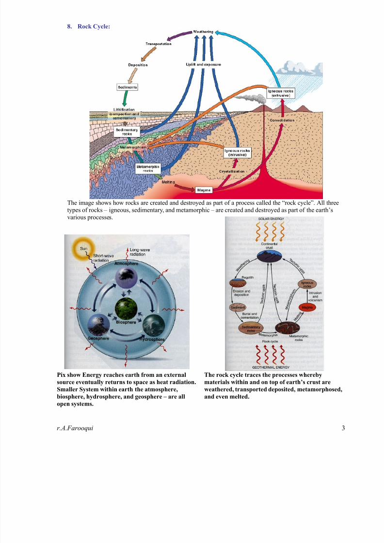
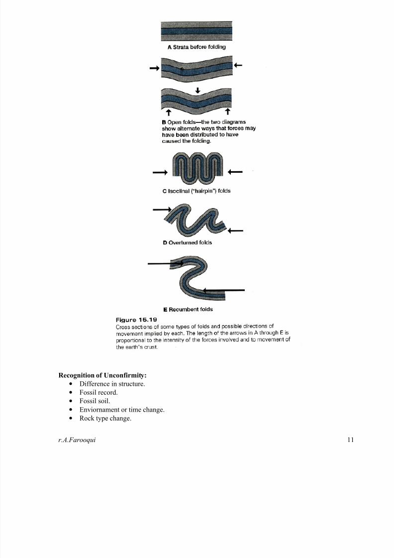
Some Fold Concepts:
8/13/2019 Test Interview Geology
http://slidepdf.com/reader/full/test-interview-geology 11/61

8/13/2019 Test Interview Geology
http://slidepdf.com/reader/full/test-interview-geology 12/61r.A.Farooqui 1
TECTONICS
Earth's structure:
• The earth consists of several different and distinct layers.
• The three main layers are the core, the mantle and the crust.
• The core is the inner part of the earth, the crust is the outer part and between them is the mantle.
• Knowledge of earth's interior is essential for understanding plate tectonics.
• The Earth is made of many layers. The deeper layers are composed of heavier materials; they ar
hotter, denser and under much greater pressure than the outer layers. • The Earth's surface is composed mostly of water, basalt and granite. Oceans cover about 70% o
Earth's surface. These oceans are up to 3.7 km deep.
The Earth’s Interior:
1. Core
2. Mantle
3. Crust
Earths Layers with
• Mohorovicic Discontinuity
• Gutenberg Discontinuity

8/13/2019 Test Interview Geology
http://slidepdf.com/reader/full/test-interview-geology 13/61r.A.Farooqui 1
The Core:
• The Core of the earth is about 1,800 miles (2,900 km) below the earth's surface.
• The core is a dense ball of the elements iron and nickel.
• It is divided into two layers, the inner core and the outer core.
• The inner core - the centre of earth - is solid and about 780 miles (1,250 km) thick. The inner cor
may have a temperature up to about 13,000°F (7,200°C = 7,500 K), which is hotter than the surfac
of the Sun. The inner core (which has a radius of about 750 miles (1,228 km) is solid.
•
The outer core is so hot that the metal is always molten. The outer core is about 1370 miles (2,20km) thick. Because the earth rotates, the outer core spins around the inner core and that causes th
earth's magnetism. The outer core is in a liquid state and is about 1,400 miles (2,260 km) thick.
• The Earth has an iron-nickel core that is about 2,100 miles in radius.
• The core is earth's source of internal heat because it contains radioactive materials which release heaas they break down into more stable substances.
The Mantle:
• The layer above the core is the mantle which is about 1,800 miles (2,900 km) thick and makes u
nearly 80 percent of the Earth's total volume.
• It begins about 6 miles (10 km) below the oceanic crust and about 19 miles (30 km) below th
continental crust.• It is composed of olivine-rich rock mainly silicon, oxygen, magnesium, iron, aluminum, an
calcium.
• The mantle is to divide into the lower mantle and the upper mantle.
• The upper mantle is rigid and is part of the lithosphere (together with the crust).
• The lower mantle flows slowly, at a rate of a few centimeters per year. The asthenosphere is a parof the upper mantle that exhibits plastic properties. It is located below the lithosphere (the crust an
upper mantle), between about 100 and 250 kilometers deep.
• Convection (heat) currents carry heat from the hot inner mantle to the cooler outer mantle. Thmantle gets warmer with depth, the highest temperatures occur where the mantle material is in
contact with the heat-producing core and is about 4,000-6,700° F (2,200-3,700° C) while the top othe mantle is about 1,600° F (870° C).
• The Gutenberg discontinuity separates the outer core and the mantle.
• The steady increase of temperature with depth is known as the geothermal gradient. The geotherma
gradient is responsible for different rock behaviors and the different rock behaviors are used t
divide the mantle into two different zones. Rocks in the upper mantle are cool and brittle, whil
rocks in the lower mantle are hot and soft (but not molten).
The Core The Mantle

8/13/2019 Test Interview Geology
http://slidepdf.com/reader/full/test-interview-geology 14/61r.A.Farooqui 1
The Crust:
• The Crust lies above the mantle and is the earth's hard outer shell which is composed of siliconaluminum, calcium, sodium and potassium.
• The crust is divided into continental plates which drift slowly (only a few centimeters each year
atop the less rigid mantle.
• There are two different types of crust. The Oceanic crust underlies the ocean basins and is thin (6-1km thick); this is where new crust is formed. The Continental crust is about 25-90 km thick. Th
lithosphere is defined as the crust and the upper mantle, a rigid layer about 100-200 km thick.
•
The thin oceanic crust is composed of primarily of basalt and the thicker continental crust icomposed primarily of granite. The low density of the think continental crust allows it to "float" i
high relief on the much higher density mantle below.
• The Mohorovicic discontinuity is the separation between the crust and the upper mantle.
Crust Type:
1. Oceanic Crust
2. Continental Crust
The Atmosphere
• It is the all kind of gaseous layer which is covered the earth.
• It is the essential part on earth for life, without this atmosphere life on earth isn't possible.
• It gives us air, water, warmth and is protecting us against harmful rays of the sun and agains
meteorites.
• This layer around the earth is a colourless, odourless, tasteless 'sea' of gases, water and fine dust.
• The atmosphere is made up of different layers with different qualities. It consists of 78% nitrogen21% oxygen, 0.93% argon, 0.03% carbon dioxide and 0.04% of other gases.
• The Troposphere is the layer where the weather happens; above this layer is the Stratosphere. Withi
the Stratosphere is the Ozone layer that absorbs the Sun's harmful ultraviolet rays. Above th
Stratosphere is the Mesosphere, the Thermosphere - in which the Ionosphere - and the Exosphere
The atmosphere is about 500 miles (800 km) thick.

8/13/2019 Test Interview Geology
http://slidepdf.com/reader/full/test-interview-geology 15/61r.A.Farooqui 1
Plate Boundaries:
Convergent Plate Boundaries:
• Convergent plate boundaries are locations where lithospheric plates are moving towards one another
• The plate collisions that occur in these areas can produce earthquakes, volcanic activity and crustadeformation.
• Three types of Convergent Plate Boundaries are:
1. Oceanic to Continental Convergent Plate Boundary
2. Oceanic to Oceanic Convergent Plate Boundary
3. Continental to Continental Convergent Plate Boundary

8/13/2019 Test Interview Geology
http://slidepdf.com/reader/full/test-interview-geology 16/61r.A.Farooqui 1
Divergent Plate Boundaries:
• Divergent plate boundaries are locations where plates are moving away from one another. Thi
occurs above rising convection currents.
• The rising current pushes up on the bottom of the lithosphere, lifting it and flowing laterally beneatit. This lateral flow causes the plate material above to be dragged along in the direction of flow.
• At the crest of the uplift, the overlying plate is stretched thin, breaks and pulls apart.
• Two Types are as:
1. Oceanic to Oceanic Divergent Plate Boundary
2. Continental to Continental Divergent Plate Boundary

8/13/2019 Test Interview Geology
http://slidepdf.com/reader/full/test-interview-geology 17/61r.A.Farooqui 1
Transform Boundary:
• Transform Plate Boundaries are locations where two plates slide past one another.
• The fracture zone that forms a transform plate boundary is known as a transform fault.
• Most transform faults are found in the ocean basin and connect offsets in the mid-ocean ridges.
• Transform faults can be distinguished from thetypical strike-slip faults because the sense of
movement is in the opposite direction.
• A strike-slip fault is a simple offset; however, atransform fault is formed between two different
plates, each moving away from the spreading center
of a divergent plate boundary.
• A smaller number of transform faults cut continental
lithosphere. The most famous example of this is the
San Andreas Fault Zone of western North America. The San Andreas connects a divergent boundar
in the Gulf of California with the Cascadia subduction zone. Another example of a transform boundary on land is the Alpine Fault of New Zealand.
• Transform faults are locations of recurring earthquake activity and faulting. The earthquakes ar
usually shallow because they occur within and between plates that are not involved in subduction
Volcanic activity is normally not present because the typical magma sources of an upwellin
convection current or a melting subducting plate are not present.

8/13/2019 Test Interview Geology
http://slidepdf.com/reader/full/test-interview-geology 18/61r.A.Farooqui 1
Major Continental Plates:1. African Plate
2. Antarctic Plate
3. Arabian Plate
4. Indian Plate
5. Australian Plate
6. Caribbean Plate
7. Cocos Plate
8. Eurasian Plate9. Juan de Fuca Plate
10. Nazca Plate
11. North American Plate
12. Pacific Plate
13. Philippines Plate
14. Scotia Plate
15. Somali Plate
16. South American Plate
Geological Evidences for Continental Drift:• The continuity of Paleozoic Fold Belts.
• The correlation of the patterns of age provinces.
• Correspondence matching of coastlines of South America and Africa.
• Reconstruction of the continents.
• Distinctive Igneous rocks can be traced between continents.
• Distinctive Stratigraphic sequence can also be correlated between adjacent continents.
• Regions containing metallogenic provinces (Manganese, Iron ore, Gold, Tin etc.) can bmatched across adjacent coastlines on such reconstructions.
• Climatic indicators are also play an important evidence for continental drift.
• Distinctive fossils can also be correlated between adjascent continents.
• Paleomagnetism can also be helped to understand continental drift.
Earthquake Classification
On the basis of focal depth:
1. Shallow Earthquake, 0 – 70 km
2. Intermediate Earthquake 70 – 300 km
3. Deep Earthquake >300km
Morphology of Subduction zone:1. Island Arc system
2. A Bulge3. Trench
4. Forearc Region
5. The Subduction complex/Accretionary Prism/1st Arc/Accretionary Wedge
6. The Forearc Basin
7. The Island Arc
8. The Remnant Arc
9. Marginal Sea/Backarc basin

8/13/2019 Test Interview Geology
http://slidepdf.com/reader/full/test-interview-geology 19/61

8/13/2019 Test Interview Geology
http://slidepdf.com/reader/full/test-interview-geology 20/61

8/13/2019 Test Interview Geology
http://slidepdf.com/reader/full/test-interview-geology 21/61r.A.Farooqui 21
GEOPHYSICS
Waves:
S-Waves (Transverse waves) propagate by a pure
shear in a direction perpendicular to the direction of
wave travel.
Body Waves can propagate
through the body of an elastic
solid and are nondescriptive.
Velocity of Body waves remains
same by changing frequency.
Two types as:
P-Waves (Longitudinal waves) propagate by
compressional dilation uniaxial strains in the direction
of wave travel.Rayliegh Waves propagate along boundary between
two dissimilar solid media, in a plane perpendicular to
the surface and containing the direction of
propagation.
S e i s m
i c
W
a v e s
a r e
t
h e
p a r c e l s
o f
e l a s t i c
s t r a i n
e n e r g y t
h a t
p r o p a g a t e
o u t w
a r d s
f r o m
a s e i s m
i c s o u r c e
l i k e
e a r t h q u a k e .
Surface Waves can propagate
only along the boundary of solid.
Two types are:
Love Waves are polarized shear wave with an
associated oscillatory particle motion parallel to the
free space and perpendicular to the direction wave
motion.
Resolution:
• It is a measure of ability to see two events separately in seismogram.
• Two types are:1. Vertical Resolution
2. Horizontal Resolution
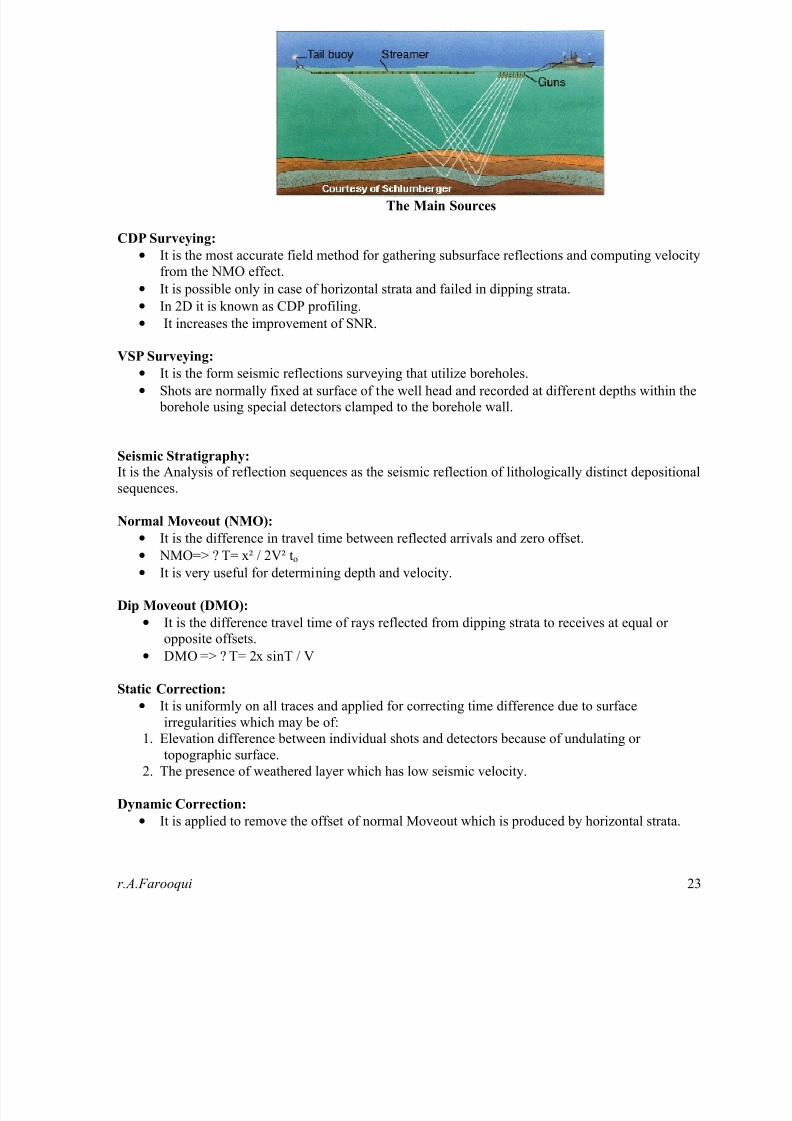
Multi Channel Seismic Reflection Surveying:
• It is the survey in which energy refracted record at different geophones from same signal shot.
• The two most common shot-detectors configurations in 2D as: 1. Split or Straddle Spread
2. Single ended Spread.
Seismic Reflection Survey
8/13/2019 Test Interview Geology
http://slidepdf.com/reader/full/test-interview-geology 22/61r.A.Farooqui 22
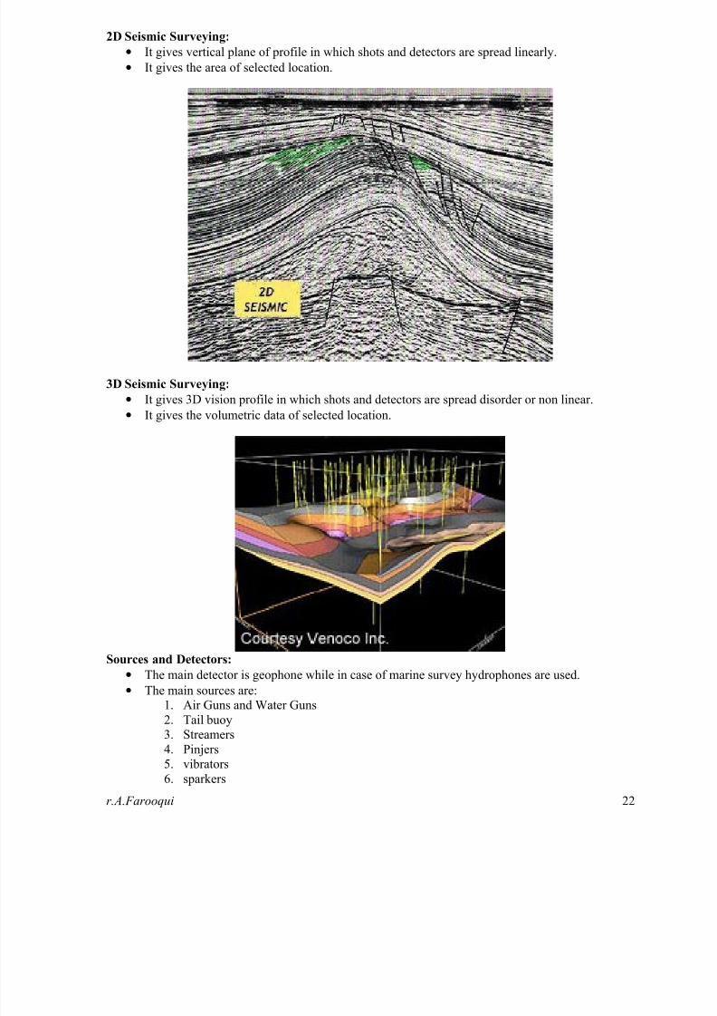
2D Seismic Surveying:
• It gives vertical plane of profile in which shots and detectors are spread linearly.
• It gives the area of selected location.
3D Seismic Surveying:
• It gives 3D vision profile in which shots and detectors are spread disorder or non linear.
• It gives the volumetric data of selected location.
Sources and Detectors:
• The main detector is geophone while in case of marine survey hydrophones are used.
• The main sources are: 1. Air Guns and Water Guns
2. Tail buoy
3. Streamers
4. Pinjers
5. vibrators
6. sparkers
8/13/2019 Test Interview Geology
http://slidepdf.com/reader/full/test-interview-geology 23/61
8/13/2019 Test Interview Geology
http://slidepdf.com/reader/full/test-interview-geology 24/61r.A.Farooqui 24
Multiples:
• They are the reflectors where rays are reflecting at the same reflection more then one time.
• Long Path Multiples generate discrete pulse length, when time difference is more between
primary and secondary reflection.
• Shot Path Multiples generate extended pulse length, when time difference is less between
primary and secondary reflection.
Migration:
• It is the process of reconstructing a seismic section so that reflections events are repositionedunder their correct surface location and at a corrected vertical reflection time.
• It also improves the resolutions of seismic solutions by focusing energy spread over a Fresnel
zone and by collapsing diffraction pattern produced by point reflector and faulted beds.
• Four types of migration are:
1. Time Migration
2. Depth Migration
3. 2D Migration
4. 3D Migration
Bright Spot Technique: It is used for locating hydrocarbon accumulation which is on true seismic section by localized zones of
anomously strong reflections.
Flat Spot Techniques: It is horizontal or near horizontal reflections events discordant to the local geological dip which is the
indication of the absence of hydrocarbon or bright spot.
Bow Tie Effect:It is the event of syncline which is resulting from the existence of discrete reflections points for any
surface locations.
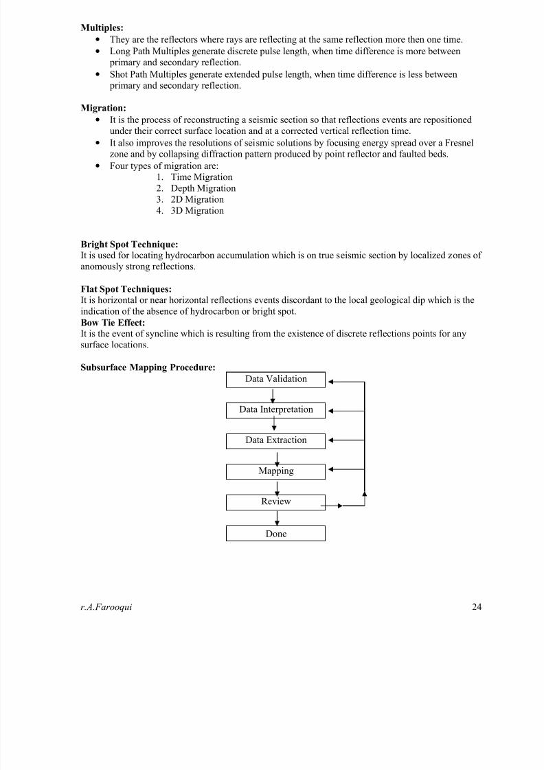
Subsurface Mapping Procedure:
Data Validation
Data Interpretation
Data Extraction
Mapping
Review
Done

8/13/2019 Test Interview Geology
http://slidepdf.com/reader/full/test-interview-geology 25/61r.A.Farooqui 25
Projection of Well:1. Plunge Projection
2. Strike Projection
3. Up or down dip Projection
4. Normal to the section line Projection
5. Parallel to Fault Projection
Types of Geophysical Maps:1. Time Structure Map
2. Depth Contour Map
3. Log Map
4. Reservoir Analysis Map (RAM)
5. Facies Analysis Map (FAM)
3D Views:
1. Fence Diagrams
2. Isometric Projections3. Log Maps
4. 3D Reservoir Analysis Model
8/13/2019 Test Interview Geology
http://slidepdf.com/reader/full/test-interview-geology 26/61r.A.Farooqui 2
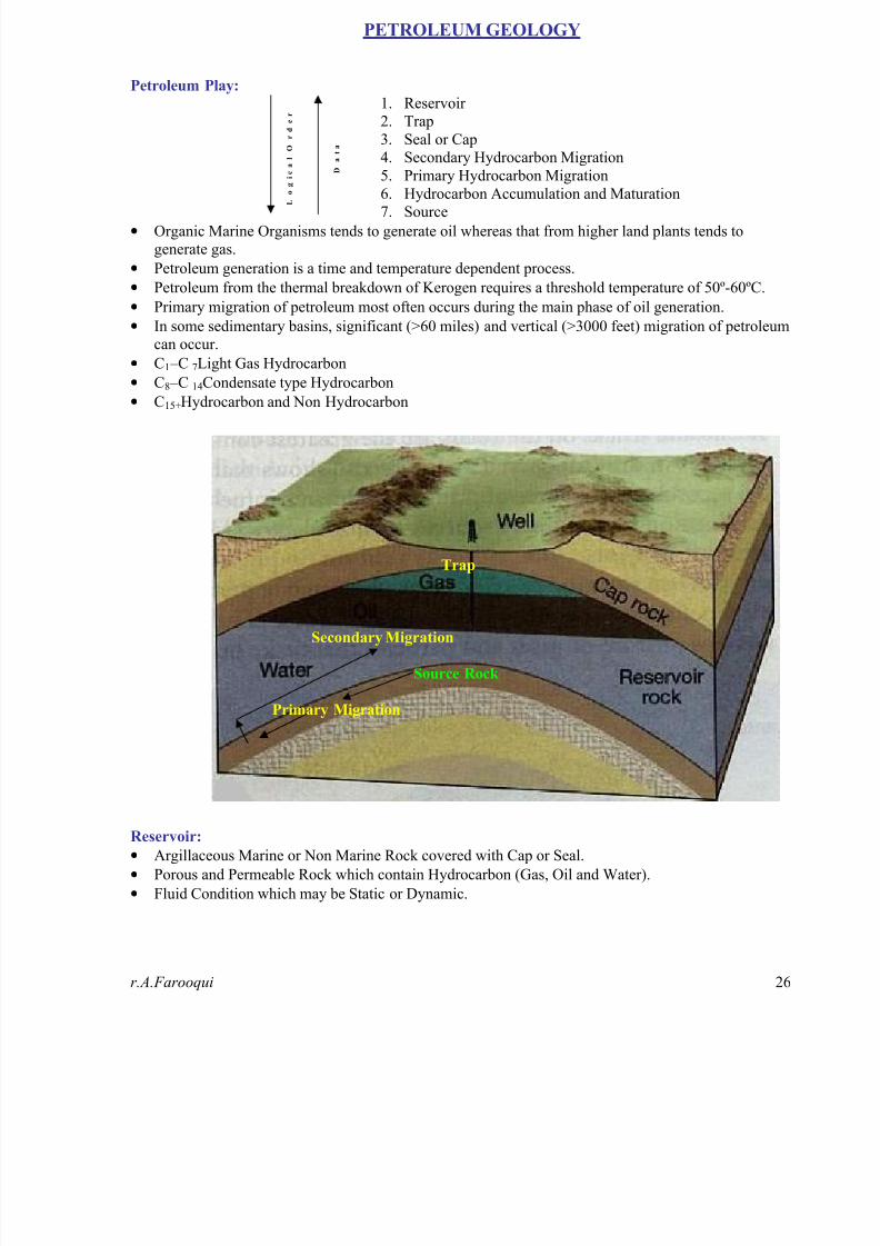
PETROLEUM GEOLOGY
Petroleum Play:
L
o g i c a l O
r d e r
D
a t a
1. Reservoir
2. Trap
3. Seal or Cap
4. Secondary Hydrocarbon Migration
5. Primary Hydrocarbon Migration
6. Hydrocarbon Accumulation and Maturation7. Source
• Organic Marine Organisms tends to generate oil whereas that from higher land plants tends to
generate gas.
• Petroleum generation is a time and temperature dependent process.
• Petroleum from the thermal breakdown of Kerogen requires a threshold temperature of 50º-60ºC.
• Primary migration of petroleum most often occurs during the main phase of oil generation.
• In some sedimentary basins, significant (>60 miles) and vertical (>3000 feet) migration of petroleum
can occur.
• C1 –C 7 Light Gas Hydrocarbon
•
C8 –C 14 Condensate type Hydrocarbon• C15+ Hydrocarbon and Non Hydrocarbon
Trap
Secondary Migration
Source Rock
Primary Migration
Reservoir:
• Argillaceous Marine or Non Marine Rock covered with Cap or Seal.
• Porous and Permeable Rock which contain Hydrocarbon (Gas, Oil and Water).
• Fluid Condition which may be Static or Dynamic.
8/13/2019 Test Interview Geology
http://slidepdf.com/reader/full/test-interview-geology 27/61r.A.Farooqui 2
Reservoir Classification:
On the Basis of:
Formation Procedure Origin and Enviornament Porosity and Permeability
1. Fragmental / Clastic /Detridal formed by
deposition which has size
colloidal from 1/256mm
(Mud) to 256mm (Boulder).
2. Chemical Reservoir Rock
formed by precipitation,evaporation or deposition of
insoluble precipitates.
3. Miscellaneous ReservoirRock formed by fracturing
which may be sedimentary,
igneous or metamorphic in
nature.
1. Marine Reservoir Rockdeposited in ocean basin or
sea water.
2. Non Marine Reservoir
Rocks deposited in fresh
water, brackish water or
glacial water.
1. Sandstone Reservoir Mechanical Porosity and
Permeability.
2. Carbonate Reservoir Chemical Porosity and
Permeability.
1. Sandstone Reservoir
• The best Sandstone Reservoir is those that are composed of primarily quartz grains of sand size,
silica cement with minimal fragmented particles.
• Particular Grain Size between 62µm to 2mm.
• Porosity and Permeability depend upon degree of Compaction.
• They are generally 25m thick, lenticular and linear spatially, less than 250km² in Area.
• The range in age from the oldest being Cambrian (in Pakistan/Algeria) to the youngest beingPliocene (Caspian Region in Ukraine) and Miocene in Pakistan. In USA, two thirds of the
sandstone reservoirs are of Cenozoic age.
• Sandstone Reservoirs forms extensive Stratigraphic Traps.
• Nearly 1mbbls of oil (42 gallon per barrel) contain sandstone reservoir of 1 sq. km in size with
an average porosity of 15%, 1m thick and saturated with oil contains 15x10^4 m³ of oil in place.
• Initial Porosity/Permeability is controlled by grain size, sorting and packing.
• Permeability decreases with grain size and with poorer sorting. • Porosity varies with sorting e.g. 28% for v. poor sorting while >42% for v. well sorting.
• Secondary changes include the authigenesis of clay and cement (e.g. Quartz, Calcite) in porespace can cause a major loss of porosity.
2. Carbonate Reservoir
• They are characterized by extremely heterogeneous porosity and permeability depend on:
a. Environment of deposition b. Digenetic alteration of the original rock fabric.
• Main Porosity types are: 1. Vuggy or Intercrystalline 2. Intergranular 3. Intragranular or Cellular 4. Chalky
• Diagenetic events leading changes in porosity and permeability:
1. Dissolution (Leaching): normally improves porosity and permeability
2. Dolomitization: produces generally vuggy porosity but porosity may increase by creating larger
pores or may reduce by the growth of crystals.
3. Fracturing: brecciation, faulting and jointing aids permeability.
4. Recrystallization: by adding neomorphism of micrite into larger crystal size enhances porosity.
5. Cementation: decreases porosity and permeability (pore threats are sealed).
• The best sorted carbonate rocks are Oolites which have same grain size and grain shape.
• Carbonates are the accumulation of the remains of carbonate secreting animals and plants. It maform in layers at slopping platforms like shelves in shallow warm saline water. It may also form
as linear or continuous reef trends, as in the case of Jhill Limestone (Unit of Gaj Formation).

8/13/2019 Test Interview Geology
http://slidepdf.com/reader/full/test-interview-geology 28/61

8/13/2019 Test Interview Geology
http://slidepdf.com/reader/full/test-interview-geology 29/61r.A.Farooqui 2
Some Associated Trap Figures
D. Salt Dome
Salt Plug Stages:
1. The Pillow stage intrusion of the overlying sediments has taken place (Trap Form ‘Domes’)
2. Diapir Stage thick clastics may Pinchout onto the flanks of the plug (Trap Form ‘Stratigraphic’)
3. The Post Diapir Stage as the Diapir grows salt is depleted and it can only continue to rise by
complete detachment from the mother salt.
Please register PDFcamp on http://www.verypdf.com/, thank

8/13/2019 Test Interview Geology
http://slidepdf.com/reader/full/test-interview-geology 30/61r.A.Farooqui 3
Seal or Cap: Factors affect the cap rock effectiveness are:
1. Lithology
• Clastic Rocks which have small pore size like Clays and Shale.
• Evaporates Rocks like Anhydrite Gypsum and Rock Salt.
• Organic rich rocks like Oolitic Limestone, Reefal Limestone.
• About 40% recoverable oil reserves are from oil fields caped by evaporates while 60% by
different types of Argillaceous rocks especially Shale. • About 34% are caped by Evaporates for Gas Fields while for Oil Fields about 66% capped b
shales.
2. Ductility (Less prone to Faulting) has following decreasing order:
Salt----Anhydrite----Organic rich Shale----Shale----Silty Shale----Calcareous Mudstone----Chert
3. Thickness
• Enogh to ensure cap pressure.
• Thick cap rock improves the chances of maintaining a seal over the entire basin.
• Cap rock thickness ranges from 10s m to 100s m.
4. Lateral Continuity
The search of the petroleum is focused on the base of regional seal, rather than in any particular
reservoir horizon in other words cover broad area.
5. Burial depth of Cap rock not an important factor but maximum depth may be important:
• Western Europe 84% 2000 to 3000m
• Africa 66% 2000 to 3000m
• Middle East 59% 1000 to 2000m
• North America 54% <1000m
Secondary Hydrocarbon Migration: The process where hydrocarbons move through a permeable carrier rock to the reservoir rock until they
are trapped in the subsurface by an impervious layer and following conditions are necessary for being
migrated hydrocarbons:1. Larger Pore Spaces
2. Fewer Capillary restrictions
3. Less semisolid or Structure Water
4. Less Fluid Pressure
Primary Hydrocarbon Migration:The process where Hydrocarbons move out of their fine grained source rock. A number of Primary
Migration has been proposed in which:
• For organic rich rocks
1. Oil Phase Migration
2. Organic Network Migration
• For organic Lean rocks
3. Molecular Solution
4. Micellar or Colloidal Solution
5. Diffusion Mechanism
6. Gas Phase Migration
8/13/2019 Test Interview Geology
http://slidepdf.com/reader/full/test-interview-geology 31/61

8/13/2019 Test Interview Geology
http://slidepdf.com/reader/full/test-interview-geology 32/61r.A.Farooqui 3
Important Indices:
Indices Symbol Farmula
Hydrogen Index HI S2/TOC
Oxygen Index OI S3/TOC, (S1/( S1+ S2))
Thermal Index TI S1/TOC
Maturation Index MIS0/ S1 / S 1+ S2+ S3,
oil and gas shows S0+ S1
Genetic Potential GP S0+ S1+ S2
Potential Yield PY S1+ S2
Sedimentation Rate:
Low High
Oxic Environment No source rock Gas prone source rock
Anoxic
Environment
Lean oil prone source
rock
Oil rich prone source
rock
Requirements for deposition and preservation of Effective Source Rock:
• High Organic Matter input
•
High Oil Proclivity of Organic Material. • Short Transport History
• Anoxic depositional condition with concentrated bacterial activity
• Low energy system
Kerogen:
Kerogen Type Kerogen Name
Associated
Organic Matter
Type
Associated
Organic Matter
Associated
Hydrocarbon
1. Type I Sapropelic Kerogens Alginite Amorphous very oil prone
2. Type II Exinitic Kerogens Exinite Herbaceous oil prone
3. Type III Vitrinitic Kerogens Liptinite/Vitrinite Woody mainly gas prone4. Type IV Inertinitic Kerogens Inertinite Coaly inert gases
Transformation of Organic Matter:
Potential
SourceTemperature Processes
Main
ProductBi-Product
1. Diagenesis Biological
Matter
<50ºC low Hydrolysis,
Decarboxylation,
Condensation,
Polymerization
Kerogen
(90%)
Biogenic
Methane,
Water, CO2
2.
CatagenesisImmature
Kerogen
50º – 150ºC int Thermal
Breakdown,
Bond Cracking,
Aromatization
Wet Gas
Hydrocarbons,
Late Mature
Kerogen
Water, CO2
3. Metagenesis Late Mature
Kerogen
>150ºC high Bond Cracking,
Aromatization
Residual
Kerogen
Methane and
Inorganic gas

8/13/2019 Test Interview Geology
http://slidepdf.com/reader/full/test-interview-geology 33/61

8/13/2019 Test Interview Geology
http://slidepdf.com/reader/full/test-interview-geology 34/61

8/13/2019 Test Interview Geology
http://slidepdf.com/reader/full/test-interview-geology 35/61r.A.Farooqui
Thermodynamic Properties of Fluid
Fluid Properties Formula Constant terms Conversion Factor
1. Pressure (p) p = znRT/V
p = ?RT/m p = ?RT pr = p / pc ppr = p / ppc
R = 10.73
psia ft³ lb-mole °RR = 82.06
atm cm³ g-mole, KR = 62.37mm Hg litters g-mole,
K
1 atm = 14.7 lb/in²
= 2116 lb/ft²= 101,300 Pa= 101.3 kPa
2. Density (?) ? = M/V? = ? /g? = mp/RT
At 20°C and 1 atm.?air = 1.205 kg/m³
= 0.0024slugs/ft³?water = 998 kg/m³
= 1.94slugs/ft³
3. Temperature (T) Tr = T / TcTpr = T / Tpc
°R = °F + 459.69°K= °C + 273
1 °K = 1.8 °R1 °R = 0.556 °K
4. Specific or unitWeight (?)
? = p/RT? = 1 / V? = ?g
At 20°C and 1 atm.?air = 11.8 N/m³
= 0.0752 lb/ft³
?water = 9790 N/m³= 62.4 lb/ft³
5. Specic Gravity(SG)
SGgas = ?gas /?airSGliquid = ?liquid
/?waterSGgas = ?gas / ?airSGgas = MW/ MWairSGliquid = ?liquid /?water
gearth = 32.174 ft/s²= 9.807 m/s²
SGHg = 13.60721SGwater = 1SGair = 1
°API = 141.5/SG – 131.5SG =141.5/(°API+131.5)
SGgas = ?gas/1.205 kg/m³SGliq = ?liq /9985 kg/m³SGgas = ?gas/11.8 kg/m³SGgas = MW/ 29SGliq = ?liq /9790 kg/m³
6. Coefficient ofViscosity (?)
? = µ / ?? is kinematic viscosity in
centistokes.µ is absolute viscosity incentipoises.? is density in gm/cm³.
1.5 – 2 centipoises at50 °F
0.7 – 1 centipoises at100 °F0.4 – 0.6 centipoises at150 °F
7. Surface Tension
(s)8. Capillarity (h)
s = rh? / 2cos?
s is surface tension.r is radius of tube.h is height of capillary.rise or depression.? is sp.weight of liquid.
? is wetting angle.
If tube is clean,
? = 0° for water? = 140° for mercury
9. IsothermalConditions p1V1 = p2V2?1 / ?2 = p1 / p2= constant
E = p
10. FormationVolume Factor (Bo)
Bo = Vres / Vsc= z T Psc / zsc Tsc p
Psc = 14.7 psia, zsc =1, Tsc = 520 °Rin bbls/SCF ÷ by 5.615
Bg = 0.0283 z T / p ft³/SCFBg = 0.005034 z T / p bbls/SCF
11. IsothermalCompressibility (Co)
Co = Cpr / ppc

8/13/2019 Test Interview Geology
http://slidepdf.com/reader/full/test-interview-geology 36/61r.A.Farooqui
General Properties of Gases
Fluid Properties Formula Constant terms Conversion Factor
1. Atomic Weight
unit (a)Molecular Weightunit (M)
M = m / n Mair = 28.97
2. Mole & Pound m = nM Avogadro No = 2.733×10^26 1 Mole = 30.07pound (lb)
3. Density (?) ? = M/V
? = ? /g? = Mp/RT
At 20°C and 1 atm.
?air = 1.205 kg/m³= 0.0024slugs/ft³
?water = 998 kg/m³= 1.94slugs/ft³
4. Pressure (p) p = znRT/V p = ?RT/m p = ?RT pr = p / pc ppr = p / ppc pc = S gi pci
R = 10.73 psia ft³ lb-mole °R
R = 82.06atm cm³ g-mole, K
R = 62.37mm Hg litters g-mole, K
1 atm = 14.7 lb/in²= 2116 lb/ft²= 101,300 Pa= 101.3 kPa
5. Temperature (T) Tr = T / Tc
Tpr = T / TpcTc = S gi Tci
°R = °F + 459.69
°K= °C + 273
1 °K = 1.8 °R
1 °R = 0.556 °K
6. Specific or unit
Weight (?)
? = p/RT
? = 1 / V? = ?g
At 20°C and 1 atm.
?air = 11.8 N/m³= 0.0752 lb/ft³
?water = 9790 N/m³= 62.4 lb/ft³
7. Specic Gravity(SG)
SGgas = ?gas /?airSGgas = ?gas / ?airSGgas = MW/MWair
gearth = 32.174 ft/s²= 9.807 m/s²
SGHg = 13.60721SGwater = 1
SGair = 1
°API = 141.5/SG – 131.5SG =141.5/(°API+131.5)SGgas = ?gas/1.205 kg/m³SGgas = ?gas/11.8 kg/m³SGgas = MW/ 29
8. IsothermalConditions
p1V1 = p2V2?1 / ?2 = p1 / p2 p1V1/T1 = p2V2/T2
=constant
9. FormationVolume Factor(Bg)
Bg = Vres / Vsc= zTPsc/zscTscp
Psc = 14.7 psia, zsc = 1,Tsc = 520 °Rin bbls/SCF ÷ by 5.615
Bg = 0.0283 z T / p ft³/SCFBg = 0.005034 z T / p bbls/SCF
10. Isothermal
Compressibility(Cg)
Cg = Cpr / ppc
Standard constant terms:
V = 379.4 ft³, p = 14.7 psia, T = 60 °F + 459.69 = 520 °R, R = 10.73 psia ft³ lb-mole °R, pr = reduced pressure, pc = critical pressure, ppr = pseudo reduced pressure, ppc = pseudo critical pressure, Tr = reduced temperature, Tc = critical temperature,Tpr = pseudo reduced temperature, Tpc = pseudo critical temperature.

8/13/2019 Test Interview Geology
http://slidepdf.com/reader/full/test-interview-geology 37/61r.A.Farooqui
Permeability Concept
1. Permeability
The ability to flow is permeability.
kro = (1- Sw - Swi )²1- Swi – Sor
krw = Sw Sw - Swi
1- SwiAbsolute permeability
ka = 1.2 × 10³ fEffective permeability of oil is given by:
kroe = kro * kaEffective permeability of water is given by:krwe = kwo * ka
Kro = Ko/KKwo = Kw/K
Kw + Ko = 1Kw + Ko + Kg = 1
2. Saturation:
Sw + So = 1Sw + So + Sg = 1
3. Flow rates:
Q = KA (? P)/µL
Qw = kroe A (? P)/µo LQo = kroe A (?P)/µo L
4. Volume:
Volume of grain => Vg = n (4/3) p r³
5. Porosity:
f = (Vb – Vg)*100 / Vb
Fluid Flow in Reservoir
Series / Harmonic Mean
=> Qt = Q1 = Q2 = Q3=> P1 – P2 = ? P1 = ? P2 = ? P3 p2 p1 => L = L1 + L2 + L3 = S Lj K3 K2K11/k = 1/L S (Li/ki) ? P1 ? P2 ? P3 Q
Radial System:k = (log re/rw) / S log (rj/rj – 1) / ki Heterogeneous System / Geometric Mean: h L1 L2 L3 log k = 1/n S log ki
Flow rate:
Q = (KA/µ) (? P/L + ?g sin ?)
W
L Parallel / Arithematic
Qt = Q1 + Q2 + Q3 P2 P2 At = A1+A2+A3k = 1/A S KiAi h1 A1 K1 Q1
Q
h2 A2 K2 Q2
h3 A3 K3 Q3
WL

8/13/2019 Test Interview Geology
http://slidepdf.com/reader/full/test-interview-geology 38/61r.A.Farooqui
Volumetric Calculation
Volumetric Calculation by different Farmulae:
• Formula 1: ? V = h/2(An + An+1)For Trapezoid
? V = Ah/3 for Pyramid
• Formula 2: ? V=h/2(An+An+1+(An*An+1)1/2 )For Successive Trapezoid
? V = Ah/3 for Pyramid
• Formula 3: ? V = h/2 (Ao+2A1+2A3+…… . . + 2An-1+An) + Avg.A
Pressure by Different formulae:
• Reservoir or Well Pressure = S p/n
• Area Average pressure = S pA / SA
• Volume Average Pressure = S pAh / SAh
Net thickness of Reservoir:
• Net thickness of Reservoir = Total thickness - (shale + impervious sandstone + claystone)
Hydrocarbon In Place
• OOIP = 7758(Ahf (1-Sw))/Bo (in STB)
• Gas MMSCF = 43.58(Ahf (1-Sw))/Bg (in MMSCF)
• Initial Gas in Place is, G1 = 43560 (f * 1-Sw *A*h) / Bgi
Recovery Reserves Concepts:
• Recovery gas volume = 43560 f (1- Sw)
• Unit Recovery = Reservoir gas volume (1/Bgi – 1/Bga)
• Recovery Factor = (1 – (Bgi/Bga ))*100
• Recovery Factor = ((1-Swi)/Bgi – Sgr/ Bga)/ ((1-Swi)/Bgi) *100
• Unit Recovery = 43650 f ((1-Swi)/Bgi – Sgr/Bga)
• Recovery gas volume = 43560 f Sgr
Gas Gravity:
• gas gravity = S yj Mj / Mair
• gas gravity = MWg/MWair
Pseudocritical Properties by browns approximation:
• Tpc = 167 + 316.678 gas gravity
• ppc = 702.5 – 50 gas gravity
Coefficient of Viscosity:
• Y1 = (9.4 + MWg) (T+ 460)^1.5
(209+19MWg+T+460)• Y2 = 3.5+0.01MWg + (986/ (T+460))
• Y3 = 2.4 – 0.2Y2
• Y4 = 0.00752*(MWg/Bg)
• Y5 = Y2 (Y4^Y3)
• µg = (Y1 (e^Y5))/1000
8/13/2019 Test Interview Geology
http://slidepdf.com/reader/full/test-interview-geology 39/61r.A.Farooqui 3
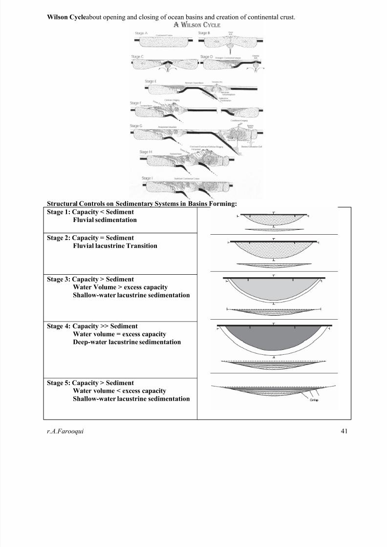
BASIN ANALYSYS• A sedimentary basin is an area in which sediments have accumulated during a particular time period at a
significantly greater rate and to a significantly greater thickness than surrounding areas.
• A low area on the Earth’s surface relative to surroundings e.g. deep ocean basin (5-10 km deep),
intramontane basin (2-3 km a.s.l.)
• Basins may be small (kms2) or large (106+ km2)
• Basins may be simple or composite (sub-basins)
• Basins may change in size & shape due to:
1. erosion
2. sedimentation3. tectonic activity
4. eustatic sea-level changes
• Basins may overlap each other in time
• Controls on Basin Formation
1. Accommodation Space,
a. Space available for the accumulation of sediment
b. T + E = S + W
T=tectonic subsidence
E= Eustatic sea level rise
S=Rate of sedimentation
W=increase in water depth2. Source of Sediment
a. Topographic Controls
b. Climate/Vegetation Controls
c. Oceanographic Controls (Chemical/Biochemical Conditions)
• The evolution of sedimentary basins may include:
1. tectonic activity (initiation, termination)
2. magmatic activity
3. metamorphism
4. as well as sedimentation
•
Axial elements of sedimentary basins:1. Basin axis is the lowest point on the basement surface
2. Topographic axis is the lowest point on the depositional surface
3. Depocentre is the point of thickest sediment accumulation
• The driving mechanisms of subsidence are ultimately related to processes within the relatively rigid,
cooled thermal boundary layer of the Earth known as the lithosphere. The lithosphere is composed of a
number of tectonic plates that are in relative motion with one another. The relative motion produces
deformation concentrated along plate boundaries which are of three basic types:
1. Divergent boundaries form where new oceanic lithosphere is formed and plates diverge. These occu
at the mid-ocean ridges.
2. Convergent boundaries form where plates converge. One plate is usually subducted beneath the
other at a convergent plate boundary. Convergent boundaries may be of different types, dependingon the types of lithosphere involved. This result in a wide diversity of basin types formed at
convergent boundaries.
3. Transform boundaries form where plates move laterally past one another. These can be complex and
are associated with a variety of basin types.
• Many basins form at continental margins.
Using the plate tectonics paradigm, sedimentary basins have been classified principally in terms of the
type of lithospheric substratum (continental, oceanic, transitional), the position with respect to a plate
boundary (interplate, intraplate) and the type of plate margin (divergent, convergent, transform) closest
to the basin.
8/13/2019 Test Interview Geology
http://slidepdf.com/reader/full/test-interview-geology 40/61r.A.Farooqui 4
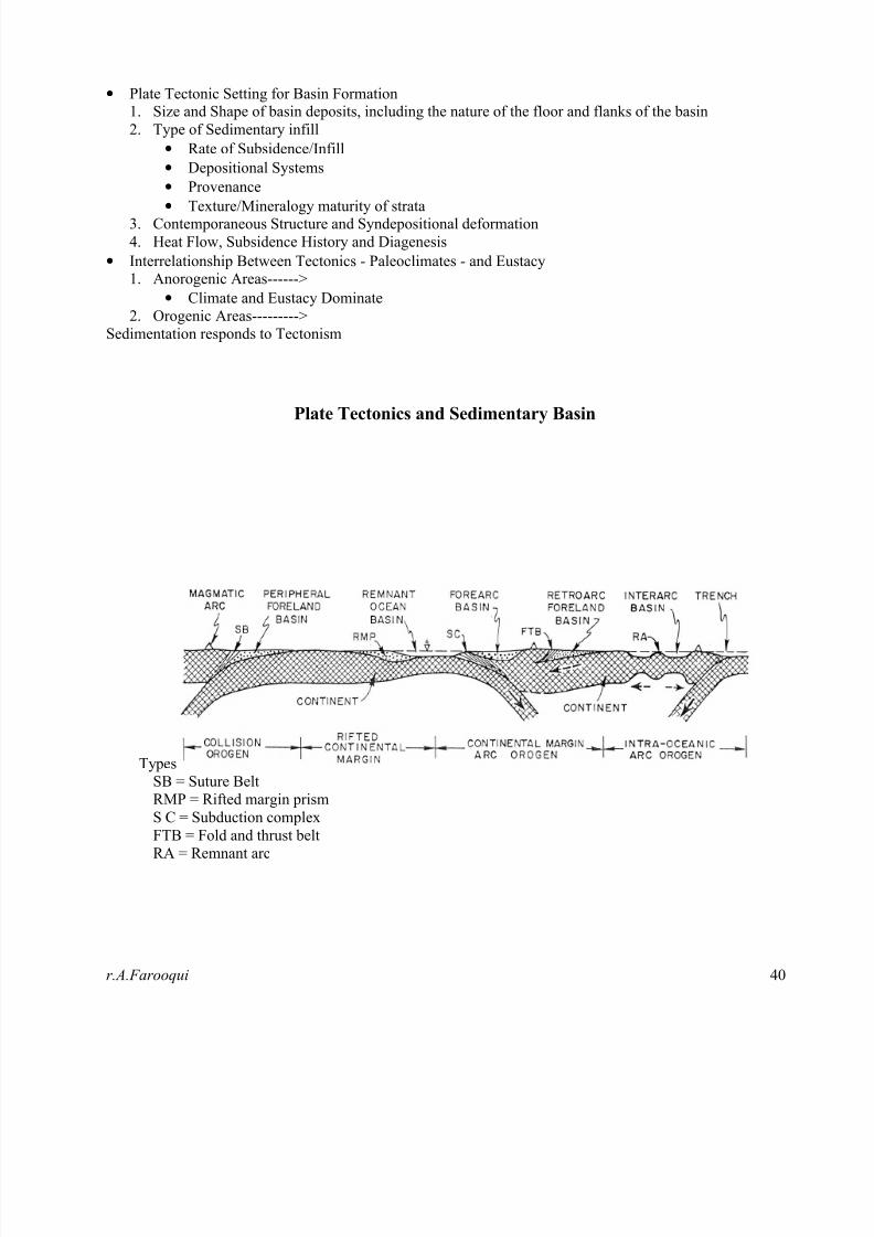
• Plate Tectonic Setting for Basin Formation1. Size and Shape of basin deposits, including the nature of the floor and flanks of the basin
2. Type of Sedimentary infill
• Rate of Subsidence/Infill
• Depositional Systems
•
Provenance• Texture/Mineralogy maturity of strata
3. Contemporaneous Structure and Syndepositional deformation
4. Heat Flow, Subsidence History and Diagenesis
• Interrelationship Between Tectonics - Paleoclimates - and Eustacy1. Anorogenic Areas------>
• Climate and Eustacy Dominate
2. Orogenic Areas--------->
Sedimentation responds to Tectonism
Plate Tectonics and Sedimentary Basin
Types
SB = Suture Belt
RMP = Rifted margin prism
S C = Subduction complex
FTB = Fold and thrust belt
RA = Remnant arc
8/13/2019 Test Interview Geology
http://slidepdf.com/reader/full/test-interview-geology 41/61

8/13/2019 Test Interview Geology
http://slidepdf.com/reader/full/test-interview-geology 42/61r.A.Farooqui 4
BASIN CLASSIFICATION:
Structural
SettingBasin Type Geological Origin Example
Intra-Plate Intracratonic basins Forms within stable continental crustal
mass
Congo Basin, Lake Eyre
Basin, Peshawar Basin.
Rift Related Basin Large scale mantle convection.
Regional updoming ± regional basaltic (flood) volcanism.
Rift basin
The down-dropped basin formed during
rifting because of stretching and thinning
of the continental crust or Result of
continental extension.
East Africa Rift
Passive margin basin
Subsidence along a passive margin,
mostly due to long-term accumulation of
sediments on the continental shelf.
East coast of North
America
Aulacogene basins Narrow continental rifts control by
normal listric Faults.
D
i v e r g e n t P
l a t e
M
a r g i n s
Oceanic Rift basinsInitially narrow may evolve into open
oceanic basins.Red Sea
Subduction Related
Basins
Two Plates subducting each other which may be collision betwee
O-O, O-C, C-C
Trench (accretionary
wedge) basin
Downward flexure of the subducting and
non-subducting plates (sites of
accretionary wedges)
Western edge of
Vancouver Island,
Modern Mariana Islands
Back arc basinSubduction faster than compression
Extensional basins
Izu-bonin arc-trench
system, west pacific
Backarc-foreland
basin
Form at active continental margins in
association with subduction and the
development of island arcs.
Forearc basin
The area between the accretionary wedge
and the magmatic arc, largely caused by
the negative buoyancy of the subducting plate pulling down on the overlying
continental crust
Georgia Strait
Retroarc foreland
basins mechanical subsidence/sediment loading
Rocky Mountain
Western interior C
o n v e r g e
n t P
l a t e
M
a r g i n s
Peripheral foreland
basins tectonic/sediment loading
“Molasses" deposits of
the Catskill (Devonian)
Deltas, Himalayan
Neogene Siwalik Hills.
Strike Slip related
Basin
strike-slip along non-linear faults
Transtensional Basins
Mechanical and Thermal
Subsidence/Uplift of
A pull-apart block (e.g. between two
transform faults) that subsides opening
"holes" or basins at fault jogs or bends
Salton Trough (Neogene
So CA, San Andreas
Fault system, USA)
T
r a n s f o r m
M
a r g i n
s
Transpressional
Basins Mechanical Subsidence/Uplift
Ridge Basin (Neogene;
So CA, San Andreas
Fault system, USA)

8/13/2019 Test Interview Geology
http://slidepdf.com/reader/full/test-interview-geology 43/61r.A.Farooqui 4
Rift Basin Passive Margin Basin
Trench Basin and Fore Land Basin Trench Basin and Forearc Basin
Transtensional Basin or Pull-apart Basin Transpressional Basin
8/13/2019 Test Interview Geology
http://slidepdf.com/reader/full/test-interview-geology 44/61r.A.Farooqui 4
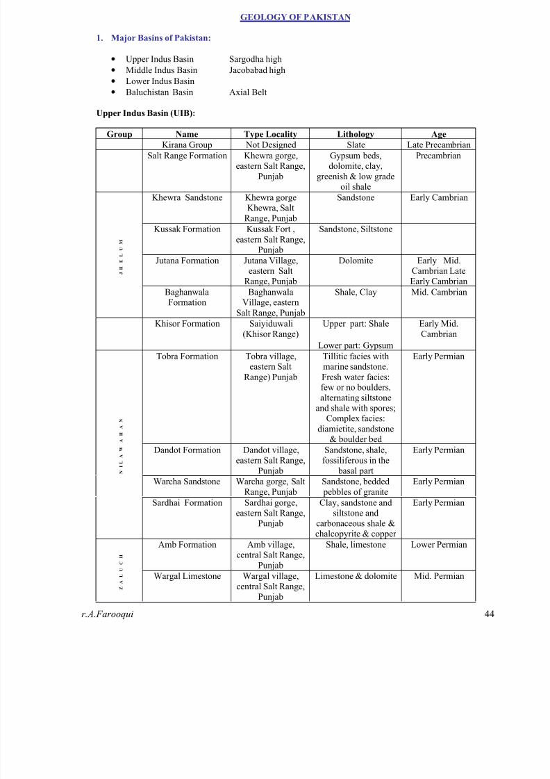
GEOLOGY OF PAKISTAN
1. Major Basins of Pakistan:
• Upper Indus Basin Sargodha high
• Middle Indus Basin Jacobabad high
• Lower Indus Basin
• Baluchistan Basin Axial Belt
Upper Indus Basin (UIB):
Group Name Type Locality Lithology Age
Kirana Group Not Designed Slate Late Precambrian
Salt Range Formation Khewra gorge,eastern Salt Range,
Punjab
Gypsum beds,dolomite, clay,
greenish & low gradeoil shale
Precambrian
Khewra Sandstone Khewra gorgeKhewra, Salt
Range, Punjab
Sandstone Early Cambrian
Kussak Formation Kussak Fort ,
eastern Salt Range,Punjab
Sandstone, Siltstone
Jutana Formation Jutana Village,eastern Salt
Range, Punjab
Dolomite Early Mid.Cambrian LateEarly Cambrian
J H
E
L
U M
BaghanwalaFormation
BaghanwalaVillage, eastern
Salt Range, Punjab
Shale, Clay Mid. Cambrian
Khisor Formation Saiyiduwali(Khisor Range)
Upper part: Shale
Lower part: Gypsum
Early Mid.Cambrian
Tobra Formation Tobra village,
eastern SaltRange) Punjab
Tillitic facies with
marine sandstone.Fresh water facies:few or no boulders,alternating siltstone
and shale with spores;Complex facies:
diamietite, sandstone& boulder bed
Early Permian
Dandot Formation Dandot village,eastern Salt Range,
Punjab
Sandstone, shale,fossiliferous in the
basal part
Early Permian
Warcha Sandstone Warcha gorge, SaltRange, Punjab
Sandstone, bedded pebbles of granite
Early Permian
N
I L
A
W
A
H
A
N
Sardhai Formation Sardhai gorge,eastern Salt Range,
Punjab
Clay, sandstone andsiltstone and
carbonaceous shale &chalcopyrite & copper
Early Permian
Amb Formation Amb village,central Salt Range,
Punjab
Shale, limestone Lower Permian
Z
A
L
U
C
H
Wargal Limestone Wargal village,central Salt Range,
Punjab
Limestone & dolomite Mid. Permian

8/13/2019 Test Interview Geology
http://slidepdf.com/reader/full/test-interview-geology 45/61

8/13/2019 Test Interview Geology
http://slidepdf.com/reader/full/test-interview-geology 46/61
8/13/2019 Test Interview Geology
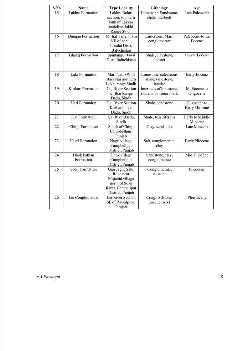
http://slidepdf.com/reader/full/test-interview-geology 47/61r.A.Farooqui 4
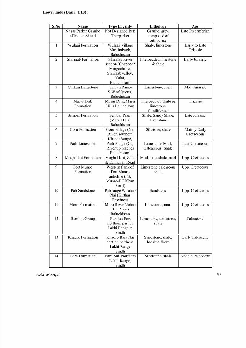
Lower Indus Basin (LIB) :
S.No Name Type Locality Lithology Age
Nagar Parkar Granite
of Indian Shield
Not Designed Ref:
Tharparker
Granite, grey,
composed oforthoclase
Late Precambrian
1 Wulgai Formation Wulgai villageMuslimbagh,
Baluchistan
Shale, limestone Early to LateTriassic
2 Shirinab Formation Shirinab Riversection (Chapppar
Mingochar &Shirinab valley,
Kalat,Baluchistan)
Interbedded limestone& shale
Early Jurassic
3 Chiltan Limestone Chiltan RangeS.W of Quetta,
Baluchistan
Limestone, chert Mid. Jurassic
4 Mazar DrikFormation
Mazar Drik, MasriHills Baluchistan
Interbeds of shale &limestone,
fossiliferous
Triassic
5 Sembar Formation Sembar Pass,(Marri Hills)Baluchistan
Shale, Sandy Shale,Limestone
Late Jurassic
6 Goru Formation Goru village (NarRiver, southern
Kirthar Range)
Siltstone, shale Mainly EarlyCretaceous
7 Parh Limestone Parh Range (GajRiver up reaches
Baluchistan)
Limestone, Marl,Calcareous Shale
Late Cretaceous
8 Moghalkot Formation Moghal Kot, Zhob
& D.I. Khan Road
Mudstone, shale, marl Upp. Cretaceous
9 Fort MunroFormation
Western flank ofFort Munro
anticline (Frt.Munro-DG Khan
Road)
Limestone calcareousshale
Upp. Cretaceous
10 Pab Sandstone Pab range Wirahab Nai (Kirthar
Province)
Sandstone Upp. Cretaceous
11 Moro Formation Moro River (JohanBibi Nani)Baluchistan
Limestone, marl Upp. Cretaceous
12 Ranikot Group Ranikot Fortnorthern part ofLakhi Range in
Sindh
Limestone, sandstone,shale
Paleocene
13 Khadro Formation Khadro Bara Naisection northern
Lakhi RangeSindh
Sandstone, shale, basaltic flows
Early Paleocene
14 Bara Formation Bara Nai, Northern
Lakhi Range,Sindh
Sandstone, shale Middle Paleocene
8/13/2019 Test Interview Geology
http://slidepdf.com/reader/full/test-interview-geology 48/61r.A.Farooqui 4
S.No Name Type Locality Lithology Age
15 Lakhra Formation Lakhra Bolarisection, southernlank of Lakkraanticline, lakhiRange Sindh
Limestone, Sandstone,shale interbeds
Late Paleocene
16 Dungan Formation Mirhat Tangi, 8km NE of hanai,Loralai Distt,Balochistan
Limestone, Marl,conglomerate
Paleocene to Lr.Eocene
17 Ghazij Formation Spintangi, HanaiDistt. Baluchistan
Shale, claystone,albaster,
Lower Eocene
18 Laki Formation Mari Nai, SW ofBara Nai northernLakhi range Sindh
Limestone, calcareousshale, sandstone,
laterite
Early Eocene
19 Kirthar Formation Gaj River SectionKirthar Range
Dadu, Sindh
Interbeds of limestone,shale with minor marl,
M. Eocene toOligocene
20 Nari Formation Gaj River SectionKirthar range,Dadu, Sindh
Shale, sandstone Oligocene toEarly Miocene
21 Gaj Formation Gaj River,Dadu,Sindh
Shale, fossiliferous Early to MiddleMiocene
22 Chinji Formation South of Chinji,Campbellpur,
Punjab
Clay, sandstone Late Miocene
23 Nagri Formation Nagri village,Campbellpur
District, Punjab
Salt, conglomerate,clay
Early Pliocene
24 Dhok PathanFormation
Dhok villageCampbellpur
District, Punjab
Sandstone, clay,conglomerate
Mid. Pliocene
25 Soan Formation Gaji Jagir, SahilRoad near
Mujahid villagenorth.of Soan
River, CampellpurDistrict, Punjab
Conglomerate,siltstone
Plieocene
26 Lei Conglomerate Lei River SectionSE of Rawalpindi
Punjab
Congl, Silstone,Eocene rocks
Pleistocene

8/13/2019 Test Interview Geology
http://slidepdf.com/reader/full/test-interview-geology 49/61
8/13/2019 Test Interview Geology
http://slidepdf.com/reader/full/test-interview-geology 50/61r.A.Farooqui 5
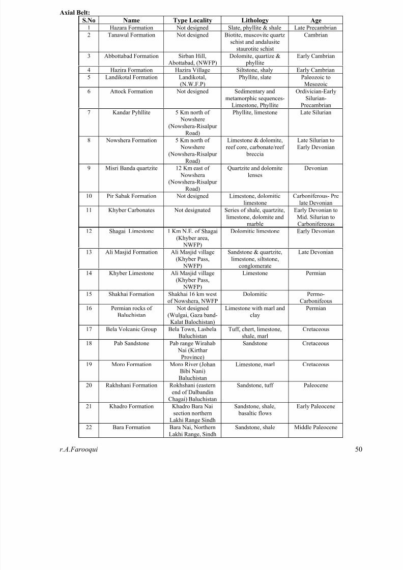
Axial Belt:
S.No Name Type Locality Lithology Age 1 Hazara Formation Not designed Slate, phyllite & shale Late Precambrian
2 Tanawul Formation Not designed Biotite, muscovite quartz
schist and andalusite
staurotite schist
Cambrian
3 Abbottabad Formation Sirban Hill,Abottabad, (NWFP)
Dolomite, quartize & phyllite
Early Cambrian
4 Hazira Formation Hazira Village Siltstone, shaly Early Cambrian
5 Landikotal Formation Landikotal,
(N.W.F.P)
Phyllite, slate Paleozoic to
Mesozoic
6 Attock Formation Not designed Sedimentary and
metamorphic sequences-
Limestone, Phyllite
Ordivician-Early
Silurian-
Precambrian
7 Kandar Pyhllite 5 Km north of
Nowshere
(Nowshera-Risalpur
Road)
Phyllite, limestone Late Silurian
8 Nowshera Formation 5 Km north of
Nowshere
(Nowshera-Risalpur
Road)
Limestone & dolomite,
reef core, carbonate/reef
breccia
Late Silurian to
Early Devonian
9 Misri Banda quartzite 12 Km east of
Nowshera(Nowshera-Risalpur
Road)
Quartzite and dolomite
lenses
Devonian
10 Pir Sabak Formation Not designed Limestone, dolomitic
limestone
Carboniferous- Pre
late Devonian
11 Khyber Carbonates Not designated Series of shale, quartzite,
limestone, dolomite and
marble
Early Devonian to
Mid. Silurian to
Carbonifereous
12 Shagai Limestone 1 Km N.E. of Shagai
(Khyber area, NWFP)
Dolomitic limestone Early Devonian
13 Ali Masjid Formation Ali Masjid village
(Khyber Pass,
NWFP)
Sandstone & quartzite,
limestone, siltstone,
conglomerate
Late Devonian
14 Khyber Limestone Ali Masjid village
(Khyber Pass,
NWFP)
Limestone Permian
15 Shakhai Formation Shakhai 16 km west
of Nowshera, NWFP
Dolomitic Permo-
Carbonifeous
16 Permian rocks of
Baluchistan
Not designed
(Wulgai, Gaza band-
Kalat Balochistan)
Limestone with marl and
clay
Permian
17 Bela Volcanic Group Bela Town, Lasbela
Baluchistan
Tuff, chert, limestone,
shale, marl
Cretaceous
18 Pab Sandstone Pab range Wirahab
Nai (Kirthar
Province)
Sandstone Cretaceous
19 Moro Formation Moro River (JohanBibi Nani)
Baluchistan
Limestone, marl Cretaceous
20 Rakhshani Formation Rokhshani (eastern
end of Dalbandin
Chagai) Baluchistan
Sandstone, tuff Paleocene
21 Khadro Formation Khadro Bara Nai
section northern
Lakhi Range Sindh
Sandstone, shale,
basaltic flows
Early Paleocene
22 Bara Formation Bara Nai, Northern
Lakhi Range, Sindh
Sandstone, shale Middle Paleocene
8/13/2019 Test Interview Geology
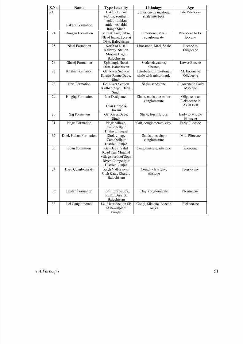
http://slidepdf.com/reader/full/test-interview-geology 51/61r.A.Farooqui 5
S.No Name Type Locality Lithology Age 23
Lakhra Formation
Lakhra Bolarisection, southern
lank of Lakkra
anticline, lakhi
Range Sindh
Limestone, Sandstone,shale interbeds
Late Paleocene
24 Dungan Formation Mirhat Tangi, 8km
NE of hanai, Loralai
Distt, Balochistan
Limestone, Marl,
conglomerate
Paleocene to Lr.
Eocene
25 Nisai Formation North of NisaiRailway. Station
Muslim Bagh,Baluchistan
Limestone, Marl, Shale Eocene toOligocene
26 Ghazij Formation Spintangi, Hanai
Distt. Baluchistan
Shale, claystone,
albaster,
Lower Eocene
27 Kirthar Formation Gaj River Section
Kirthar Range Dadu,Sindh
Interbeds of limestone,
shale with minor marl,
M. Eocene to
Oligocene
28 Nari Formation Gaj River Section
Kirthar range, Dadu,
Sindh
Shale, sandstone Oligocene to Early
Miocene
29 Hinglaj Formation Not Designated
Talar Gorge &Jiwani
Shale, mudstone minor
conglomerate
Oligocene to
Pleistocene in
Axial Belt
30 Gaj Formation Gaj River,Dadu,
Sindh
Shale, fossiliferous Early to Middle
Miocene
31 Nagri Formation Nagri village,
Campbellpur
District, Punjab
Salt, conglomerate, clay Early Pliocene
32 Dhok Pathan Formation Dhok village
Campbellpur
District, Punjab
Sandstone, clay,
conglomerate
Mid. Pliocene
33 Soan Formation Gaji Jagir, Sahil
Road near Mujahid
village north.of Soan
River, CampellpurDistrict, Punjab
Conglomerate, siltstone Plieocene
34 Haro Conglomerate Kech Valley near
Gish Kaur, Kharan,Balochistan
Congl , claystone,
siltstone
Pleistocene
35 Bostan Formation Pishi Lora valley,
Pishin District.Baluchistan
Clay, conglomerate Pleistocene
36 Lei Conglomerate Lei River Section SE
of Rawalpindi
Punjab
Congl, Silstone, Eocene
rocks
Pleistocene

8/13/2019 Test Interview Geology
http://slidepdf.com/reader/full/test-interview-geology 52/61r.A.Farooqui 5
Northern Montane Area:
S.No Name Type Locality Lithology Age
1 Salkhala Formation Salkhala village,Kishan Ganja
River, Kashmir
Slate Late Precambrian
2 Cambrian rocks of N.E. (undefine)
Greywacke, shale andlimestone
Cambrian
3 Devonian rock -
Chitral
- Limestone Early Devonian
4 Sarikol Slate Not designed Slate, quartzite,
calcareous beds andfew volcanic rock
Carboniferous-
Permian
5 Darkot Group Not designed Slate, Limestone,quartzite,
conglomerate, schist,marble, gneiss and
volcanic rocks
Permo -Carbonifeous
6 Chalt Schist Not designated(SW of Chalt
Hunza)?
Schist, quartz biotiteschist, phyllite
Carboniferous-Permian
7 Baltit Group Not designated
(near BaltitHunza)?
Garnet staurolite,
schist, garnet, micaschist, garnet
amphibolite, coarsely,crystalline marble, and
micaceous.
Carboniferous-
Permian
8 Pasu Slate Not designated(Pasu valley
Gilligit)?
Interbedded withquartzite and
limestone
Carboniferous-Permian
9 Panjal Formation &Agglomerate Slate
Not designated (atapex of Hazara
syntaxis)?
Volcanic greenstone,metamorphosed lava
flows
Carboniferous-Permian
References:www.gsp.com.pk
“Geology & Tectonic of Pakistan” by Kazmi & Jan.
“Petroleum Geology of Pakistan” by I.B Kadri.
Prepared by: Rehan.A Farooqui
M.Sc Geology,,
University of Karachi.

8/13/2019 Test Interview Geology
http://slidepdf.com/reader/full/test-interview-geology 53/61r.A.Farooqui 5
2. Petroleum Basin Plays:
• Baluchistan Basin Play:
Age Formation Lithology
Seal/Cap Parkini Shale
ReservoirMiocene
Panjgur Sandstone
Source Oligocene Hoshab/Siahan Shales
• Upper Indus Basin Play:
Age Formation Lithology Oil/Gas Fields
Seal/Cap Kussak Shale
Reservoir
EarlyCambrian Khewra Sandstone
Source PrecambrianSehwal Marl Member of
Salt Range FormationMarly Shale
AdhiMissa Keswal
Gas /Condensate
Seal/Cap Dandot Shale
ReservoirEarly Permian
Tobra Conglomerate
Source M.Cambrian Baghanwala Shale
Seal/Cap Sardhai Clayey Shale
Reservoir Warcha SandstoneSource
Early PermianDandot Shale
Seal/Cap Early Triassic Mianwali Shale
Reservoir Late PermianZaluch Group (Amb
Wargal Chidru)Limestone
Source Early Permian Sardhai Clay Shale
Adhi, Dhurnal Oil
Seal/Cap Shiniwari Shale
ReservoirEarly Jurassic
Datta Sandstone
Source Late Triassic Kingriali Marly Shale
Seal/Cap Late Jurassic Chichali Shale
Reservoir Mid. Jurassic Samansuk Limstone
Source Early Jurassic Shiniwari Shale
Dhulian, Toot,
Meyal, Dkhni Oil
Seal/Cap Patala Shale
Reservoir Lochart Limastone
Source
Paleocene
Hangu Shaly Sand
Seal/Cap Chorgali Sahly Marl
Reservoir Sakessar Limestone
Source
Early Eocene
Nammal Shaly Marl
Seal/Cap Murree Clayey Shale
Reservoir Chorgali Limestone
Source
Eocene
Nammal/Sakessar Shalr Part
Dhurnal, Chak Naurang,Balkassar,
Dakhni
Oil
• Paleocene and Eocene Shale are proven source rocks in UIB.
• Cumulative thickness of Reservoirs is about 800 to 1000 maters.

8/13/2019 Test Interview Geology
http://slidepdf.com/reader/full/test-interview-geology 54/61r.A.Farooqui 5
• Middle Indus Basin Plays:
Age Formation Lithology Oil/Gas Fields
Seal/Cap Lower Goru(Lower Sahle
and Talhar
Shale)
Shale
Reservoir Lower Goru(Basal Sandand Massive
Sand)
Sandstone
Source
EarlyCretaceous
Sembar Shale
Seal/Cap Early Paleocene Ranikot Shale part
Reservoir Late Cretaceous Pab Sandstone
SourceLate to EarlyCretaceous
Mughal Kot /
Fort Munro /Sembar
Shale
PirKoh, Rodho,
Dhodhak
Gas /
Condensate
Seal/Cap Late Paleocene Bara/Lakhra Shale
Reservoir Early Paleocene Ranikot Limestone/Sandstone
Source E. Cretaceous Sembar Shale
PirKoh, Rodho,Dhodhak
Gas /Condensate
Seal/Cap Domanda
Member
Shale
ReservoirMid. Eocene Habib Rahi Limestone
Source E.Eocen/ E.Cret Baska / Sembar Shale
Seal/Cap E. Eocene Ghazij Shale
ReservoirMid. Eocene
Sui upperLimestone
Limestone
Source L. Paleocene toL. Cretaceous
Lakhra /Sembar
Shale
Seal/Cap E. Eocene Ghazij Shale
Reservoir
Mid. Eocene
Sui main
Limestone Limestone
Source L. Paleocene toL. Cretaceous
Lakhra /Sembar
Shale
Sui, Kandkhot,Loti, Zin, Uch,
Khairpur,Mazarani.
Gas
• Sembar is proven source rock in MIB.
• Cumulative thickness of Reservoirs about 1500 meters.
• Lower Indus Basin Plays:
Age Formation Lithology Oil/Gas Fields
Seal/Cap Lower Goru(Lower Sahle
and Talhar
Shale)
Shale
Reservoir Lower Goru(Basal Sand
and MassiveSand)
Sandstone
Source
EarlyCretaceous
Sembar Shale
Badin,Khaskheli,
Laghari,Mazari, Turk,
Golarchi, Mial,Kadanwari,
Sehwan, Bhit
Gas / Oil
Seal/Cap Late Paleocene Bara/Lakhra Shale
Reservoir Early Paleocene Ranikot Limestone/Sandstone
Source E. Cretaceous Sembar Shale
Sari, Hindi,
Kothar Gas
• Cumulative thickness of Reservoirs about 400 meters.
Reference:
“Petroleum Geology of Pakistan” by I.B Kadri.
8/13/2019 Test Interview Geology
http://slidepdf.com/reader/full/test-interview-geology 55/61r.A.Farooqui 5
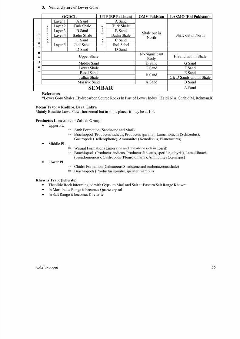
3. Nomenclature of Lower Goru:
OGDCL UTP (BP Pakistan) OMV Pakistan LASMO (Eni Pakistan)
Layer 1 A Sand A Sand
Layer 2 Turk Shale Turk Shale
Layer 3 B Sand B Sand
Layer 4 Badin Shale Badin Shale
C Sand C Sand
Jhol Sahel Jhol Sahel U
p p e r
S a n d
Layer 5
D Sand
U
p p e r
S a n d
D Sand
Shale out in North
Shale out in North
Upper Shale No Significant
BodyH Sand within Shale
Middle Sand D Sand G Sand
Lower Shale C Sand F Sand
Basal Sand E Sand
Talhar ShaleB Sand
C& D Sands within Shale
L
O
W
E R
G
O
R
U
Massive Sand A Sand B Sand
SEMBAR A Sand
Reference:
“Lower Goru Shales; Hydrocarbon Source Rocks In Part of Lower Indus”, Zaidi.N.A, Shahid.M, Rehman.K
Decan Trap: = Kadhro, Bara, LakraMainly Basaltic Lawa Flows horizontal but in some places it may be at 10°.
Productus Limestone: = Zaluch Group
• Upper PLð Amb Formation (Sandstone and Marl)ð Brachiopod (Productus indicus, Productus spiralis), Lamellibrachs (Schizodus),
Gastropods (Bellerophone), Ammonites (Xenodiscus, Planetoceras)
• Middle PLð Wargal Formation (Limestone and dolostone rich in fossil)ð Brachiopods (Productus indicus, Productus lineatus, sperifer, athyris), Lamellibrachs
(pseudomonotis), Gastropods (Pleurotomaria), Ammonites (Xenaspis)• Lower PL
ð Chidro Formation (Calcareous Snadstone and carbonaceous shale) ð Brachiopods (Productus spiralis, sperifer marcoui)
Khewra Trap: (Kherite)
• Theolitic Rock intermingled with Gypsum Marl and Salt at Eastern Salt Range Khewra.
• In Mari Indus Range it becomes Quartz crystal
• In Salt Range it becomes Khewrite
8/13/2019 Test Interview Geology
http://slidepdf.com/reader/full/test-interview-geology 56/61r.A.Farooqui 5
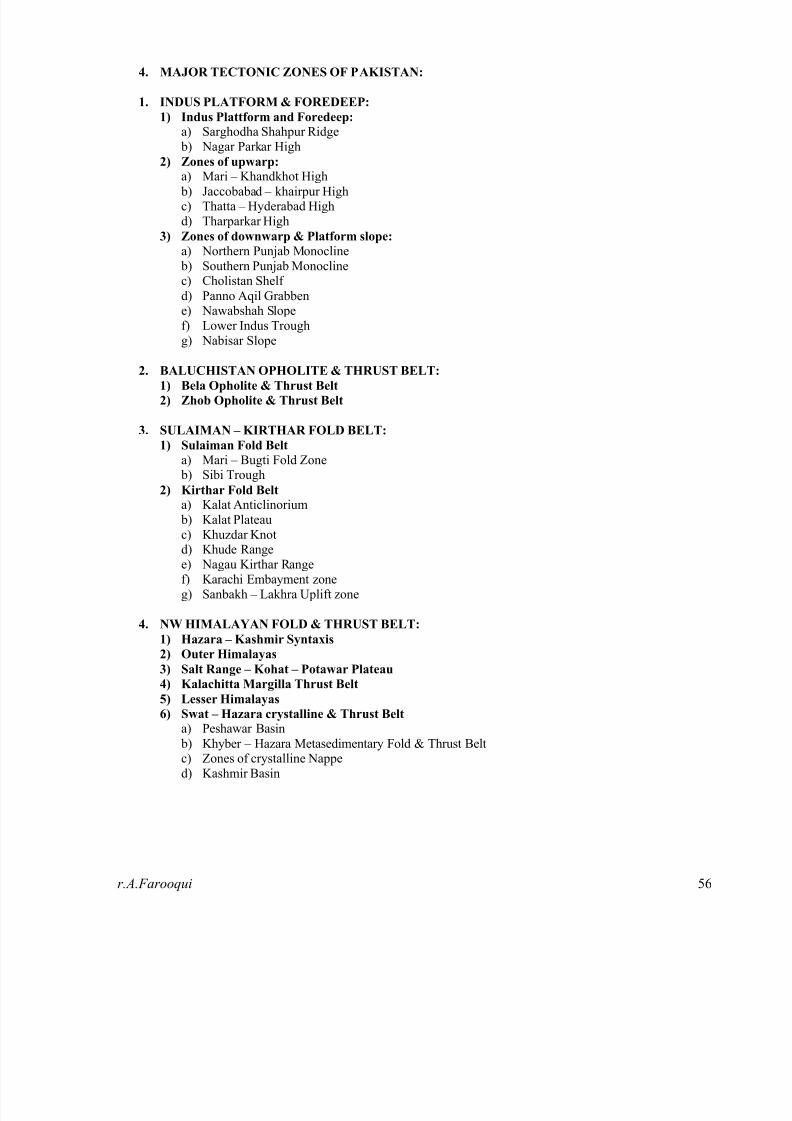
4. MAJOR TECTONIC ZONES OF PAKISTAN:
1. INDUS PLATFORM & FOREDEEP:
1) Indus Plattform and Foredeep:
a) Sarghodha Shahpur Ridge b) Nagar Parkar High
2) Zones of upwarp:
a) Mari – Khandkhot High b) Jaccobabad – khairpur Highc) Thatta – Hyderabad Highd) Tharparkar High
3) Zones of downwarp & Platform slope:
a) Northern Punjab Monocline b) Southern Punjab Monoclinec) Cholistan Shelf
d) Panno Aqil Grabbene) Nawabshah Slopef) Lower Indus Troughg) Nabisar Slope
2. BALUCHISTAN OPHOLITE & THRUST BELT:
1) Bela Opholite & Thrust Belt
2) Zhob Opholite & Thrust Belt
3. SULAIMAN – KIRTHAR FOLD BELT:
1) Sulaiman Fold Belt
a) Mari – Bugti Fold Zone b) Sibi Trough
2) Kirthar Fold Belt
a) Kalat Anticlinorium
b) Kalat Plateauc) Khuzdar Knotd) Khude Rangee) Nagau Kirthar Rangef) Karachi Embayment zoneg) Sanbakh – Lakhra Uplift zone
4. NW HIMALAYAN FOLD & THRUST BELT:
1) Hazara – Kashmir Syntaxis
2) Outer Himalayas
3) Salt Range – Kohat – Potawar Plateau
4) Kalachitta Margilla Thrust Belt
5) Lesser Himalayas6) Swat – Hazara crystalline & Thrust Belt
a) Peshawar Basin
b) Khyber – Hazara Metasedimentary Fold & Thrust Beltc) Zones of crystalline Napped) Kashmir Basin

8/13/2019 Test Interview Geology
http://slidepdf.com/reader/full/test-interview-geology 57/61

8/13/2019 Test Interview Geology
http://slidepdf.com/reader/full/test-interview-geology 58/61r.A.Farooqui 5
NON-METALLIC MINERAL RESOURCES
OF PAKISTAN
MINERAL/COMMOD
ITY
RESERVES
(In Tons)
LOCATION QUALITY
Barite 30,000,000 Lasbela, Khuzdar -
Balochistan Hazara -
NWFP
Mostly drilling mud
type
Building Stones V.L.D. Many districst of
Balochistan - NWFP -
Sindh
Good
Cement Raw Material V.L.D. All provinces of
Pakistan
V. Good
Clays (including China
Clay)
+34,000,000 NWFP - Punjab - Sindh Good
Coal 184,000 MT Sindh, Balochistan,
Sindh,
N.W.F.P.Mianwali,
Attock - Punjab
Lig. A to Bit. A
Dolomite V.L.D. Jhimpir - Sindh Medium
Fire Clay 100,000,000 Kala Chitta and SaltRange - Punjab Meting
Jhimpir - Sindh
Good
Fluorite 100,000 Kalat Good
Fuller's Earth F.L.D. Khairpur, Dadu - Sindh Good
Gemstone N.E. Northern Areas Good
Gypsum and Anhydrite 350,000,000 Salt Range, D.G.Khan -
Punjab Spintangi -
Balochistan, Dadu -
Sindh
Good
Limestone V.L.D. All provinces and AJK Good
Magnesite 12,000,000 Abbottabad - NWFPMuslimbagh, Wad -
Balochistan
Medium
Marble/Aragonite V.L.D. Chagai - Balochistan
Noushehra - NWFP
V. Good
Phosphate 22,000,000 Kakul - NWFP Medium to low grade
Rock Salt V.L.D. Salt Range - Punjab V. Good
Silica Sand V.L.D. Surghar Range - Punjab
Thano Bulla Khan -
Sindh
Medium
Soap Stone 600,000 Parachinar - NWFP Good
Sulphur 800,000 Koh-i-Sultan -
Balochistan
Medium to low grade
Keys: -
N.E. Not Estimated
F.L.D. Fairly Large Deposits
V.L.D. Very Large Deposits
MT Million Tons
Lig. Lignite
Bit. Bituminous

8/13/2019 Test Interview Geology
http://slidepdf.com/reader/full/test-interview-geology 59/61
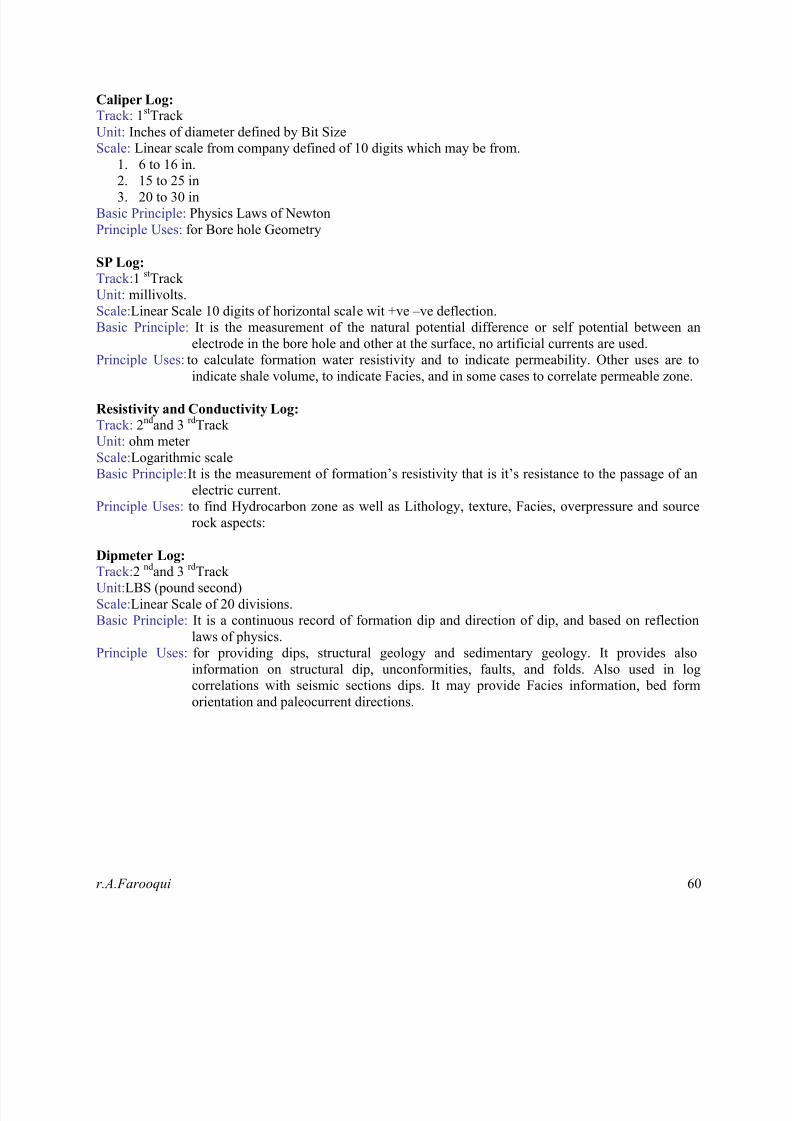
8/13/2019 Test Interview Geology
http://slidepdf.com/reader/full/test-interview-geology 60/61r.A.Farooqui 60
Caliper Log:Track: 1st Track
Unit: Inches of diameter defined by Bit Size
Scale: Linear scale from company defined of 10 digits which may be from.
1. 6 to 16 in.
2. 15 to 25 in
3. 20 to 30 in
Basic Principle: Physics Laws of Newton
Principle Uses: for Bore hole Geometry
SP Log:
Track: 1 st Track
Unit: millivolts.
Scale: Linear Scale 10 digits of horizontal scale wit +ve –ve deflection.
Basic Principle: It is the measurement of the natural potential difference or self potential between an
electrode in the bore hole and other at the surface, no artificial currents are used.Principle Uses: to calculate formation water resistivity and to indicate permeability. Other uses are to
indicate shale volume, to indicate Facies, and in some cases to correlate permeable zone.
Resistivity and Conductivity Log:
Track: 2nd and 3 rd Track
Unit: ohm meter
Scale: Logarithmic scale
Basic Principle: It is the measurement of formation’s resistivity that is it’s resistance to the passage of an
electric current.
Principle Uses: to find Hydrocarbon zone as well as Lithology, texture, Facies, overpressure and source
rock aspects:
Dipmeter Log:
Track: 2 nd and 3 rd Track
Unit: LBS (pound second)
Scale: Linear Scale of 20 divisions.
Basic Principle: It is a continuous record of formation dip and direction of dip, and based on reflection
laws of physics.
Principle Uses: for providing dips, structural geology and sedimentary geology. It provides also
information on structural dip, unconformities, faults, and folds. Also used in log
correlations with seismic sections dips. It may provide Facies information, bed form
orientation and paleocurrent directions.

8/13/2019 Test Interview Geology
http://slidepdf.com/reader/full/test-interview-geology 61/61
Triangle
(Law of Cosines)
c2 a2 b2 2ab cos
Area 1
2bh
a
b
hc
θ
h a sin
Right Triangle
(Pythagorean Theorem)
c2 a2 b2
a
b
c
Equilateral Triangle
Area 3s2
4
s
s
hs
h 3s
2
Parallelogram
b
hArea bh
Trapezoid a
h
b
a
b
h
Area h
2a b
Circle
Circumference 2 r
r Area r 2
Sector of Circle
in radians
s
r
Area r 2
2r
s
θ
Circular Ring
di
Sector of Circular Ring
Area pw
in radians
w width of ring,w
p
θ
p average radius,
Ellipse
Circumference 2 a2 b2
2
a
bArea ab
Cone
Volume Ah
3
h
A
A area of base
Right Circular Cone
Lateral Surface Area r r 2 h2
r
h
Volume r 2h
3
Frustum of Right Circular Cone
Lateral Surface Area s R r
h R
r
sVolume
r 2 rR R2h
3
Right Circular Cylinder
Lateral Surface Area 2 rh
r
hVolume r 2h
Sphere
Surface Area 4 r 2r
Volume 4
3 r 3
WedgeAA f f
FORMULAS FROM GEOMETRY