
Teignbridge Local Planicm9.teignbridge.gov.uk/tgov/media/pdf/d/c/FS1_-_Participant... ·...
56
31 July 2013 Teignbridge Local Plan Matter 11: Chudleigh Participant Statement Prepared by Savills on behalf of the Clifford Estate Company Savills (UK) Limited Embassy House Queens Avenue Bristol BS8 1SB
Transcript of Teignbridge Local Planicm9.teignbridge.gov.uk/tgov/media/pdf/d/c/FS1_-_Participant... ·...
31 July 2013
Teignbridge Local Plan
Matter 11: Chudleigh
Participant Statement
Prepared by Savills on behalf of the Clifford Estate Company
Savills (UK) Limited
Embassy House
Queens Avenue
Bristol
BS8 1SB
Page 1 of 6
Teignbridge Core Strategy Participant Statement by Savills on behalf of the Clifford Estate Company
Matter 11: Chudleigh
This Statement is submitted by Savills on behalf of The Clifford Estate Company (CEC).
CEC own a large area of land to the north and east of Chudleigh, including the area which
falls within the Policy CH2 allocation of the Local Plan.
The contents of this Statement supplement the representations previously submitted to the
Submission Draft Local Plan.
Background
Considerable work has been undertaken on behalf of CEC to assess the environmental and
technical considerations pertaining to the future development of the land within the Policy
CH2 allocation for a mix of housing and enhanced sports facilities. These studies include:
• Initial Highways Assessment;
• Bat Mitigation Framework;
• Archaeological Evaluation;
• Flood Risk Assessment; and
• Sports Club Requirement Study.
The purpose of the studies is to identify potential constraints to development and to ensure
that the necessary mitigation is considered holistically through the development of a
Masterplan for the site. The studies relating to archaeology and flood risk identified no
potential constraints to the delivery of development and no requirement to incorporate
specific mitigation at this stage.
The Sports Club Requirement Study provides a qualitative and quantitative assessment of
the expansion requirements for the Chudleigh Sports Club, which it is intended to deliver as
part of the wider application proposals. This study has been produced in order to inform the
masterplanning of the sports provision and its integration with the proposed residential
development.

Page 2 of 6
Teignbridge Core Strategy Participant Statement by Savills on behalf of the Clifford Estate Company
Matter 11: Chudleigh
The Bat Mitigation Framework and Initial Highways Assessment are the two areas of
particular importance in respect of the deliverability of the Policy CH2 allocation. Close
liaison has taken place between the appointed ecologist and highways consultant in order to
devise a technical solution to achieving a suitable and safe access in a manner which will
not have a detrimental impact upon the protected bat population at Chudleigh Caves and
Woods (part of the South Hams SAC). It is these two assessments to which reference will
be drawn in the subsequent sections of this Statement.
Structure of this Statement
This Statement addresses the three elements of questions 68 and 69 posed in the Draft
Programme, issued on 30 July 2013. The three questions are as follows:
Is the proposed density appropriate?
Can any effects on Bats be mitigated satisfactorily?
The cumulative impact of the above proposal [CH1, CH2, CH3, CH4, CH5, CH6]
on the sustainability of the greater horseshoe bat population emanating from the
caves at the nearby South Hams Special Area of Conservation.
The subsequent sections of this Statement address these questions in turn.
1. Is the proposed density appropriate?
On behalf of CEC we have advocated through Representations to the Local Plan that
the area of land allocated under Policy CH2 should be increased to include the land
outlined in red on the attached plan (see Appendix 1).
The reason for this is threefold. Firstly, the Chudleigh Community Masterplan, which
was adopted in September 2011, included within the ‘Vision Diagram’ a hatched area of
land identified as a potential development opportunity (see Appendix 2). The hatched
area on the Vision Diagram corresponds with the plan hatched at Appendix 1 and it is

Page 3 of 6
Teignbridge Core Strategy Participant Statement by Savills on behalf of the Clifford Estate Company
Matter 11: Chudleigh
therefore consistent with the Community Masterplan to broaden the area to include
within the allocation.
Secondly, the extension of the allocated land further east would not, in our view, have
any detrimental impact upon environmental considerations. Indeed, the eastern part of
the field which it is proposed is included within the allocation, is relatively flat and there
are no specific field boundaries which indicate that allocation of the smaller area would
be more appropriate.
Thirdly, an increase in the area of land available for the development will provide greater
flexibility for masterplanning the delivery of the allocation. Indeed, it will enable careful
integration of green infrastructure and strategic landscaping within an area entirely
contained in the allocated site as defined in the Local Plan. The increased flexibility
would be beneficial in ensuring all necessary mitigation can be accommodated within
the area of land allocated for the development.
In conclusion, we do not consider there would be any harm to widening the extent of the
current allocation of Policy CH2 on the proposals map. On the contrary, doing so would
be consistent with the Chudleigh Community Masterplan, reflect the topography and
characteristics of the site and provide increased flexibility to ensure the development
can be addressed in full within the allocation boundaries established through the Local
Plan.
2. Can any effects on Bats be mitigated satisfactorily?
As outlined in the Background section, very careful consideration has been given to the
potential effects of proposed development on the bat population at Chudleigh Caves
and Woods. To that end, CEC commissioned the production of a Bat Mitigation
Framework from specialist consultants EAD Ecological Consultants in 2012. A copy of
the Draft Bat Mitigation Framework, dated May 2012 is attached at Appendix 3 of this
Statement.
Page 4 of 6
Teignbridge Core Strategy Participant Statement by Savills on behalf of the Clifford Estate Company
Matter 11: Chudleigh
The Draft Bat Mitigation Framework was submitted to Natural England and a response
received on 19 June 2012. The response provides four comments relating to further
surveys and the design of mitigation for a subsequent planning application. These
comments are welcomed and can be fully addressed through the subsequent planning
application process. In concluding, the penultimate paragraph of the response letter (a
full copy of which is attached at Appendix 4) states that:
“‘We welcome your request for input at this stage as this will ensure that any
matters can be addressed in good time in advance of any potential planning
application. Other than the comments provided above we consider that the
principles put forward in your document are sound and provide a good
framework.”
Whilst further work is clearly required, there is no reason to believe at this stage that the
delivery of the Policy CH2 allocation is in any way prejudiced by the bat population of
Chudleigh Caves and Woods. Continued liaison will take place with Natural England to
ensure that the required mitigation is integrated into the application proposals.
EAD Ecological Consultants have considerable experience of dealing with the potential
impacts of development on ecology, including protected bat species. Their Framework
report addresses the two principal considerations where bats are concerned and
outlines the proposed mitigation principles. The two potential impacts of development
on bats arise from:
i) Loss of bat foraging habitat; and
ii) Impact on bat flyways.
The Policy CH2 allocation is within such proximity to the bat roosts at Chudleigh Caves
and Woods, that the land represents a potential source of bat foraging habitat. In order
to address this impact, arrangements will be made through the subsequent planning
application process for land elsewhere within the CEC ownership to be improved for bat
foraging.
Page 5 of 6
Teignbridge Core Strategy Participant Statement by Savills on behalf of the Clifford Estate Company
Matter 11: Chudleigh
There is considerable land available within the ownership of CEC and initial discussions
have taken place with the ecologist at Teignbridge District Council regarding the extent
and location of a suitable bat compensation habitat.
The replacement habitat will more than compensate for the development on the site and
lead to a positive overall benefit for the bat population at Chudleigh Caves and Woods.
The other potential impact of development is on the bat flyways and the green
infrastructure which the bat population use to navigate to and from the roost. Following
dialogue between the Highways consultant and EAD Ecological Consultants, it has been
possible to identify a solution which achieves a suitable and appropriate highways
access, but does not have any significant detrimental impact upon the bat flyways.
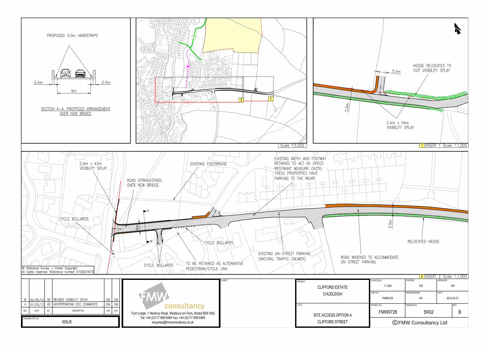
Attached at Appendix 5 is a copy of correspondence between the Highways consultant
and Devon County Council Highways Authority. This includes a plan showing the
proposed access arrangements for the site and the correspondence confirming ‘in
principle’ acceptance of this approach by the Highways Authority.
The location of the junction and highways works have been identified by the Ecological
consultants as being the most appropriate location at which to introduce a new bridge
across Kate Brook. The location is preferred due to the minimal impact that it would
have on existing vegetation and lighting.
The access scheme which has received ‘in principle’ approval from the Highways
Authority is therefore considered to be both suitable and achievable from a highways
and ecological perspective. Given this, and the mitigation proposed to compensate for
the loss of bat foraging habitat, we do not consider that there are any effects on the bat
population which cannot be mitigated as part of the development proposals for the
Policy CH2 allocation.

Page 6 of 6
Teignbridge Core Strategy Participant Statement by Savills on behalf of the Clifford Estate Company
Matter 11: Chudleigh
3. The cumulative impact of the above proposal [CH1, CH2, CH3, CH4, CH5,
CH6] on the sustainability of the greater horseshoe bat population
emanating from the caves at the nearby South Hams Special Area of
Conservation
For the reasons outlined above we do not consider that there will be any detrimental
impact on the bat population at Chudleigh Caves and Woods arising from the
development of the Policy CH2 allocation. CEC has not undertaken a specific
assessment of the other allocations at Chudleigh or the impact that these will have on
either bat foraging habitat or bat flyways.
Notwithstanding, it will be for each landowner / developer to ensure that their application
proposals do not have a detrimental impact on protected species, including the bat
population. We have no reason to believe at this stage that this would not be
achievable.

Appendix 1
Proposed Allocation Site Boundary
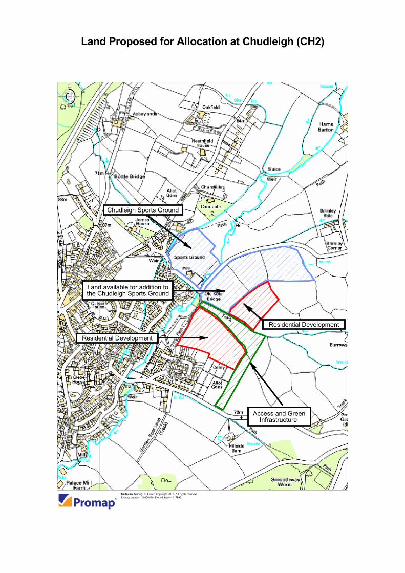
Chudleigh Sports Ground
Land available for addition tothe Chudleigh Sports Ground
Residential Development
Access and GreenInfrastructure
Residential Development
Land Proposed for Allocation at Chudleigh (CH2)
Ordnance Survey © Crown Copyright 2012. All rights reserved. Licence number 100020449. Plotted Scale - 1:7500

Appendix 2
Extract from the Chudleigh Community Masterplan

1
Chudleigh Community Masterplan September 2011
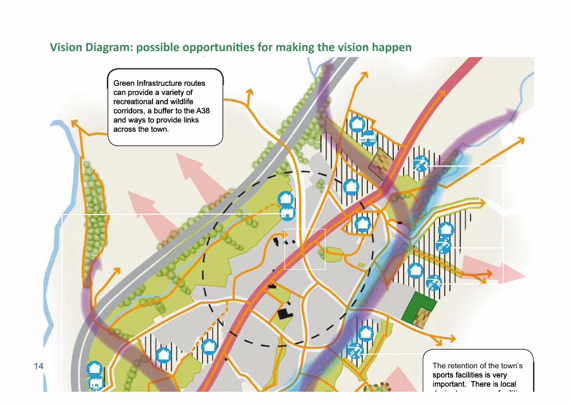
14 The retention of the town’s sports facilities is very important. There is local desire to see more facilities
Green Infrastructure routes can provide a variety of recreational and wildlife corridors, a buffer to the A38 and ways to provide links across the town.
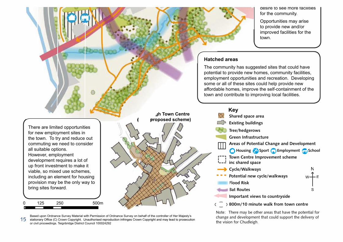
15
desire to see more facilities for the community.
Opportunities may arise to provide new and/or improved facilities for the town.
Based upon Ordnance Survey Material with Permission of Ordnance Survey on behalf of the controller of Her Majesty’s
or civil proceedings. Teignbridge District Council 100024292
Hatched areasThe community has suggested sites that could have potential to provide new homes, community facilities, employment opportunities and recreation. Developing some or all of these sites could help provide new affordable homes, improve the self-containment of the town and contribute to improving local facilities.
Note: There may be other areas that have the potential for change and development that could support the delivery of the vision for Chudleigh.
0 125 250 500m
There are limited opportunities for new employment sites in the town. To try and reduce out commuting we need to consider all suitable options.However, employment development requires a lot of up front investment to make it viable, so mixed use schemes, including an element for housing provision may be the only way to bring sites forward.
Chudleigh Town Centre Chudleigh Town Centre (draft proposed scheme)(draft proposed scheme)
N
S
W E

Appendix 3
Draft Bat Mitigation Framework
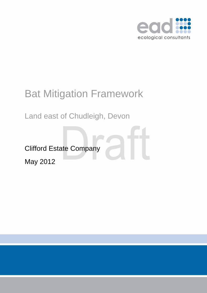
Bat Mitigation Framework Land east of Chudleigh, Devon
Clifford Estate Company
May 2012
Status Produced by Checked by Date
Draft (Team review) Hayden Torr Matt Jones 23.5.2012
3 Colleton Crescent
Exeter
EX2 4DG
Tel: 01392 260420
Fax: 01392 434603
Email: [email protected]
www.eadconsult.co.uk
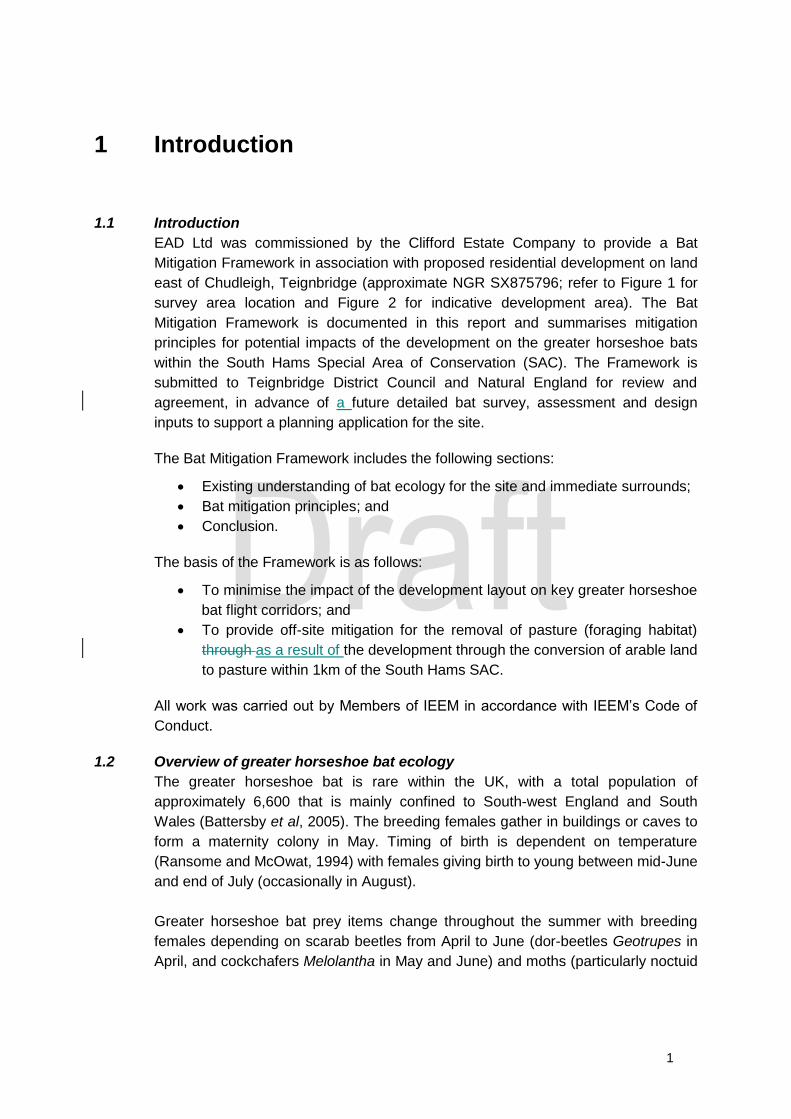
Contents
1 Introduction 1
1.1 Introduction 1
1.2 Overview of greater horseshoe bat ecology 1
1.3 Approach 2
2 Ecological baseline 4
2.1 Existing information 4
2.2 Habitats within survey area boundary 5
2.3 Survey of land use surrounding the SAC 7
3 Bat Mitigation Principles 8
3.1 Mitigation within development area 8
3.2 Off-site mitigation 9
4 Summary 10
4.1 Approach 10
4.2 Further survey, assessment, design and consultation 10
5 References 1211
Figures
Figure 1: Location plan
Figure 2: Indicative development area
Figure 3: Bat Mitigation Framework Plan
Figure 4: Strategic areas and sustenance zones for greater horseshoe bats from
Chudleigh Caves (part of the South Hams SAC)
Figure 5: Chudleigh Caves bat features and sites
Figure 6: SAC Site-screening plan for development sites in and around Chudleigh
(Kestrel Wildlife Consultants, March 2011).
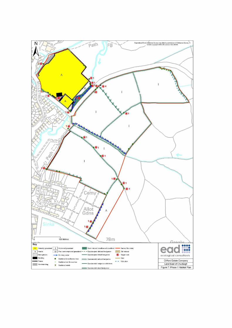
Figure 7: Phase 1 Habitat Plan
Appendices
Appendix 1: Species legislation and conservation status
1
1 Introduction
1.1 Introduction
EAD Ltd was commissioned by the Clifford Estate Company to provide a Bat
Mitigation Framework in association with proposed residential development on land
east of Chudleigh, Teignbridge (approximate NGR SX875796; refer to Figure 1 for
survey area location and Figure 2 for indicative development area). The Bat
Mitigation Framework is documented in this report and summarises mitigation
principles for potential impacts of the development on the greater horseshoe bats
within the South Hams Special Area of Conservation (SAC). The Framework is
submitted to Teignbridge District Council and Natural England for review and
agreement, in advance of a future detailed bat survey, assessment and design
inputs to support a planning application for the site.
The Bat Mitigation Framework includes the following sections:
Existing understanding of bat ecology for the site and immediate surrounds;
Bat mitigation principles; and
Conclusion.
The basis of the Framework is as follows:
To minimise the impact of the development layout on key greater horseshoe
bat flight corridors; and
To provide off-site mitigation for the removal of pasture (foraging habitat)
through as a result of the development through the conversion of arable land
to pasture within 1km of the South Hams SAC.
All work was carried out by Members of IEEM in accordance with IEEM’s Code of
Conduct.
1.2 Overview of greater horseshoe bat ecology
The greater horseshoe bat is rare within the UK, with a total population of
approximately 6,600 that is mainly confined to South-west England and South
Wales (Battersby et al, 2005). The breeding females gather in buildings or caves to
form a maternity colony in May. Timing of birth is dependent on temperature
(Ransome and McOwat, 1994) with females giving birth to young between mid-June
and end of July (occasionally in August).
Greater horseshoe bat prey items change throughout the summer with breeding
females depending on scarab beetles from April to June (dor-beetles Geotrupes in
April, and cockchafers Melolantha in May and June) and moths (particularly noctuid
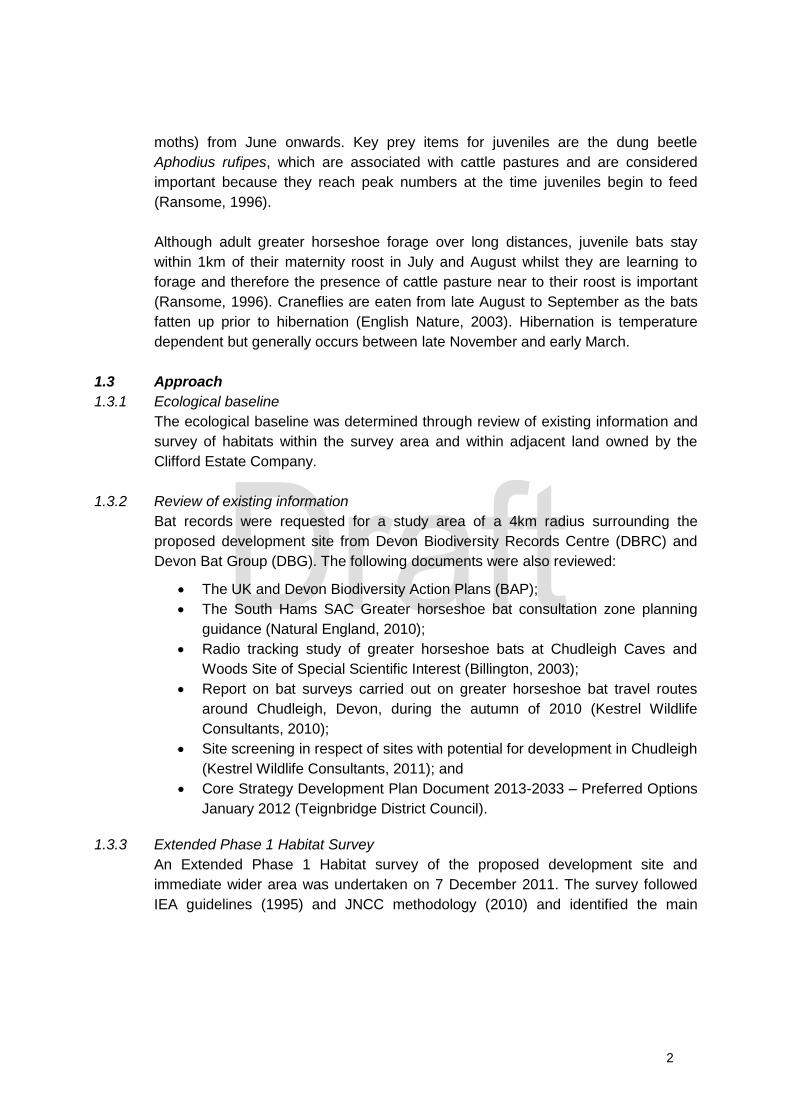
2
moths) from June onwards. Key prey items for juveniles are the dung beetle
Aphodius rufipes, which are associated with cattle pastures and are considered
important because they reach peak numbers at the time juveniles begin to feed
(Ransome, 1996).
Although adult greater horseshoe forage over long distances, juvenile bats stay
within 1km of their maternity roost in July and August whilst they are learning to
forage and therefore the presence of cattle pasture near to their roost is important
(Ransome, 1996). Craneflies are eaten from late August to September as the bats
fatten up prior to hibernation (English Nature, 2003). Hibernation is temperature
dependent but generally occurs between late November and early March.
1.3 Approach
1.3.1 Ecological baseline
The ecological baseline was determined through review of existing information and
survey of habitats within the survey area and within adjacent land owned by the
Clifford Estate Company.
1.3.2 Review of existing information
Bat records were requested for a study area of a 4km radius surrounding the
proposed development site from Devon Biodiversity Records Centre (DBRC) and
Devon Bat Group (DBG). The following documents were also reviewed:
The UK and Devon Biodiversity Action Plans (BAP);
The South Hams SAC Greater horseshoe bat consultation zone planning
guidance (Natural England, 2010);
Radio tracking study of greater horseshoe bats at Chudleigh Caves and
Woods Site of Special Scientific Interest (Billington, 2003);
Report on bat surveys carried out on greater horseshoe bat travel routes
around Chudleigh, Devon, during the autumn of 2010 (Kestrel Wildlife
Consultants, 2010);
Site screening in respect of sites with potential for development in Chudleigh
(Kestrel Wildlife Consultants, 2011); and
Core Strategy Development Plan Document 2013-2033 – Preferred Options
January 2012 (Teignbridge District Council).
1.3.3 Extended Phase 1 Habitat Survey
An Extended Phase 1 Habitat survey of the proposed development site and
immediate wider area was undertaken on 7 December 2011. The survey followed
IEA guidelines (1995) and JNCC methodology (2010) and identified the main

3
habitats and the presence/potential presence of protected and notable1 species.
The results of the survey were detailed on a Phase 1 Habitat plan. Target notes
were used to identify specific features of ecological interest and a botanical species
list was recorded, although no attempt was made to record every plant species
within the survey area.
1.3.4 Survey of landuse surrounding the SAC
Aerial photographs of land within the ownership of the Clifford Estate Company that
occurred within 1km of the South Hams SAC boundary were analysed for land-use
category e.g. pasture, arable. A site survey was undertaken on 14 February 2012 to
ground-truth the location of arable fields.
1 Notable species are those which hold a specific conservation status e.g. Biodiversity Action Plan
Priority Species, IUCN Red Data Species. Some notable species may also be legally protected.
4
2 Ecological baseline
2.1 Existing information
Chudleigh Caves and Woods Site of Special Scientific Interest (SSSI), which is a
constituent of the South Hams Special Area of Conservation (SAC), lies 310m
south of the survey area boundary. The SAC is designated for its ancient semi-
natural woodland and broadleaved plantation, with caves that provide important
roosts for greater horseshoe bats; refer to Figure 3. The primary greater horseshoe
bat roost is located at Pixies Hole (approximate NGR SX856786; refer to Figure 3),
which is a natural cave system that supports a greater horseshoe bat maternity
roost and hibernation roost.
The proposed development site lies within a ‘Sustenance Zone’ and ‘Strategic
Flyway’ for greater horseshoe bats from the SAC; refer to Figures 3 and 4. These
have been identified by Natural England in their document ‘South Hams SAC –
Greater horseshoe bat consultation zone planning guidance’ (Natural England,
2010) and are defined as follows:
Sustenance zone – key feeding and foraging zone. 4km radius centred on
each of the component roosts of the South Hams SAC.
Strategic flyways – key network of flight path zones connecting the
component roosts of the South Hams SAC.
A radio-tracking survey of the greater horseshoe bats from Chudleigh Caves and
Woods SSSI was undertaken in 2002 (Billington, 2003). Twenty bats were radio-
tracked to identify their principle foraging areas and flight routes. The survey
identified several main commuting routes including along the Kate Brook
immediately to the west of the proposed development site; refer to Figure 5. Several
more local flyways were also identified, including a route along the hedgerow that
bisects the proposed development area; refer to Figure 5 and 7.
Further surveys of the greater horseshoe radio-tracking routes identified on Figure 5
were undertaken by Kestrel Wildlife Consultants in Autumn 2010. No greater
horseshoe bats were recorded along the “central portion of the Kate Brook”, which
they conclude “is very likely to be due to the artificial lighting [along the footpath]
which has been installed since Billington did his study” (Kestrel Wildlife Consultants,
2010).
The Council commissioned a ‘Screening Report’ for a number of sites identified in
the Strategic Housing Land Availability Assessment (SHLAA) in and around
Chudleigh with respect to potential impacts on greater horseshoe bats (Kestrel
Wildlife Consultants, March 2011). Areas 18 and 19 within the Report cover the
5
majority of the proposed development area; refer to Figure 6. Area 13 addressed
Chudleigh Sports Ground, which lies to the immediate west of the proposed
development site and was included in the Extended Phase 1 survey area; refer to
Figure 7.
The Report classified both areas to the east of the Sports Ground, Brimley Corner
Lane and Kate Brook (Areas 18 and 19) as both ‘Amber’ to ‘Red’ suitability for
development. The details of the assessment for Areas 18 and 19 states that
“development of the [Areas] might not pose any significant threat to the integrity of
the SAC” in terms of loss of foraging habitat but impacts could occur through
adverse effects on flight corridors i.e. the Strategic Flyways. The Report classified
Chudleigh Sports Ground (Area 13) as of ‘Amber’ suitability for development and
could therefore be developed, providing adequate mitigation was integrated into the
development layout.
Teignbridge District Council has included Areas 13, 18 and 19 as Allocation CH2
‘Land north east of Chudleigh’ in the Core Strategy DPD 2013-2033: Preferred
Options Strategy (Consultation) January 2012. The Strategy states that detailed bat
survey data, along with a mitigation scheme, will need to accompany all planning
applications in the area. In allocating the site, the Council seeks to promote the site
for residential, recreation and ‘green infrastructure’. Planning approval for sports
pitches to the north of the proposed residential area has been granted; refer to
Figure 3.
In addition to greater horseshoe bats, DBRC and DBG have previous records of
brown long-eared, common pipistrelle, soprano pipistrelle, Daubenton’s
whiskered/Brandt’s, noctule, Natterer’s, serotine, barbastelle and lesser horseshoe
bats within 4km of the survey area; refer to Appendix 1 for species legislation and
conservation status). All bats are legally protected and some are UK and Devon
BAP Priority Species e.g. greater horseshoe bat.
2.2 Habitats within survey area boundary
The habitats present within the survey area (proposed development site and
immediate adjacent areas) are described below and their locations and target notes
are shown on Figure 7. In the text, plant species are referred to using English
names.
2.2.1 Amenity grassland
This habitat was present within the sports fields in the north-west of the survey
area. The grassland was species-poor with a very short, mown sward. Species
present included dandelion, daisy and perennial ryegrass.

6
2.2.2 Arable field
Part of a single arable field comprised the southern section of the survey area. At
the time of survey this field was ploughed with margins of less than 0.5m of tall
ruderal weeds.
2.2.3 Buildings
Several single-storey buildings were present in the north-west of the survey area,
with use associated with the sports field. These had pre-fabricated flat roofs with
wooden-panelled or rendered walls, and although some bat access points were
present, they were considered to have low bat-roost potential. A single derelict cow
shed was present along the northern boundary of the survey area (Target Note 4;
Figure 7). This was open-fronted and had stone walls with a corrugated steel roof
and wooden beams. It was considered to have potential for nesting passerines and
as a potential occasional night roost for horseshoe bats.
2.2.4 Hedgerows
A variety of hedgerows were present on the survey area. These included species-
rich and species-poor hedgerows with and without mature trees. The species-rich
hedgerows comprised a variety of species including oak, hazel, hawthorn,
blackthorn, spindle, holly, field maple, ash, dog-rose, elm, elder, willow species,
alder and honeysuckle. The ground flora contained upright hedge-parsley, dog’s-
mercury, harts-tongue fern, soft shield fern, ground-ivy and ivy. The species-poor
hedgerows were largely dominated by hawthorn and blackthorn or non-native
species such as garden privet.
All hedgerows are UK BAP Priority Habitats and some of the hedgerows within the
survey area were potentially ‘Important’ according to the Hedgerow Regulations
1997 (as amended). Species-rich hedgerows are also Devon BAP Priority Habitats.
2.2.5 Improved grassland
Improved grassland pasture fields occurred throughout the survey area and were
dominated by perennial rye-grass, red fescue, Yorkshire fog, white clover and
creeping buttercup. The sward was generally short and cattle-grazed with low
botanical and structural diversity.
2.2.6 Poor semi-improved grassland
A narrow strip of poor semi-improved grassland was located along the south-east of
the sports field. This had a short sward, and low botanical and structural diversity.
Species included Yorkshire-fog, false-oat grass, Cock’s-foot, rough meadow-grass
and creeping buttercup, with broadleaved dock, perennial rye-grass and dove’s-foot
crane’s-bill also recorded.
7
2.2.7 Running water and ditches
Kate Brook, a tributary of the River Teign, flowed through broadleaved woodland to
the southeast of the sports field and west of the proposed development area.
Streams and ditches were also present throughout the survey area. The stream that
bisected the proposed development area was fast-flowing with steep earth/mud
banks and a gravel/pebble bed substrate. Priority Habitat Action Plans for streams
occur within the UK and Devon BAPs.
2.2.8 Scattered broadleaved and coniferous trees
Several mature trees were present along field boundaries throughout the survey
area; species composition was dominated by ash and oak. Many of the large
mature oak trees were considered to have moderate to high bat roost potential.
2.2.9 Scattered scrub
This occurred along several field margins, and was dominated by bramble scrub.
2.2.10 Semi-natural broadleaved woodland
A narrow strip of semi-natural broadleaved woodland was present in the northwest
of the survey area, along either side of Kate Brook. Species composition varied and
included ash, hazel, alder, holly, oak, field maple and willow. The ground flora
comprised dog’s mercury, bramble, harts-tongue fern, nettle and ivy.
2.2.11 Tall ruderal
This habitat was generally dominated by common nettle, with other species
including hogweed, broadleaved dock and willowherb species.
2.3 Survey of land use surrounding the SAC
Seventeen arable fields within 1km of the South Hams SAC boundary were present
on land within the ownership of the Clifford Estate Company. Five of these fields
were considered to be of high ‘potential value’ (i.e. if converted to pasture) to
greater horseshoe bats as they occurred within 1km of the main greater horseshoe
bat roost at Pixies Hole (refer to Sections 1.2 and 2.1). Four fields were located to
the north-east of Pixies Hole and three of the fields were to the south; refer to
Figure 3.
8
3 Bat Mitigation Principles
3.1 Mitigation within development area
3.1.1 Flight corridors
The Illustrative Masterplan seeks to accord with allocation CH2 in the Core Strategy
DPD: Preferred Options (Teignbridge District Council, January 2012) whilst
maintaining key flight corridors for greater horseshoe bats; refer to Figure 2. The
majority of existing trees and hedgerows would be retained within the development
area. Structural planting is proposed around development zones, including
additional screening to protect the Kate Brook; refer to Figure 2. The identified flight
corridor along the central east corridor and stream would be enhanced further
through tree planting and creation of a wildflower meadow e.g. to benefit bat prey
items such as noctuid moths.
The detailed design of the access road which crosses the wildlife corridor would
incorporate crossing provision for greater horseshoe bats. The exact details would
be confirmed following completion of bat surveys of the site and could include
sufficiently large underpasses suitable for horseshoes in accordance with Highways
Agency Guidance (Highways Agency 2011). Landscape planting and/or fencing
would be installed to direct bats towards the mitigation structure.
Further ecological design inputs would be undertaken as the scheme progressed, in
accordance with the results of further bat activity survey (as well as the results of
other protected/notable species). A Landscape and Ecological Management
Strategy would be produced and submitted with the planning application, which
would detail the aims, objectives and management principles required to maintain
retained and proposed habitats. The Strategy would also include details of post-
construction monitoring of the flight corridors.
3.1.2 Lighting
The lighting scheme for the development would be designed to ensure that ‘dark
corridors’ (not exceeding 0.5 lux) would be maintained along the key flight corridors.
To inform the lighting scheme, including associated mitigation measures, a lighting
assessment would be undertaken including assessment of pre-development
ambient light levels and post-development light levels including lux contour plans
from street lighting and modelling of likely light-spill from traffic and residential
properties. The lighting scheme and assessment would be agreed with Devon
County Council, Natural England and Teignbridge District Council prior to the
submission of the planning application.
9
3.2 Off-site mitigation
The proposed development would result in the loss of approximately 4.76ha of
improved cattle pasture. However, loss of these pastures would be mitigated by
conversion of approximately 15.6ha of arable fields to cattle pasture, including
approximately 7.7ha of land adjacent the development site. This would increase the
overall amount of potential greater horseshoe foraging habitat within 1km of the
main roost at Pixie’s Hole by approximately 10.84ha. All fields proposed for
conversion are immediately adjacent to greater horseshoe bat flight corridors that
were identified by Billington (2003).
The fields would be cattle grazed and stocked at an appropriate density to
encourage scarab beetles including dung-beetles and cockchafers. Cattle
husbandry would ensure that such beetles could occur e.g. cattle would not be
treated with Ivermectin. Hedgerows around the perimeter of the identified fields
would be managed to improve their value as flight and foraging corridors for bats.
The management of all fields, including stock density and cattle husbandry, would
be specified in an Ecological Management Plan; this would form an appendix to the
main Landscape and Ecological Management Strategy and would delivered through
a Section 106 Agreement.
10
4 Summary
4.1 Approach
It is considered that the proposed mitigation framework provides a viable approach
to the mitigation of the proposed residential development at the proposed
locationon land to east of Chudleigh. The agreement to the framework is sought
from Teignbridge District Council and Natural England. It is important to clarify that
the Clifford Estate Company is not requesting agreement to the proposed
development layout and precise mitigation measures at this stage. Moreover,
agreement is sought that the framework represents a viable way forward at this
stage so that the Clifford Estate Company can progress more detailed survey,
assessment, design and consultation to support a planning application for
residential development.
4.2 Further survey, assessment, design and consultation
Following agreement to the framework, detailed bat surveys of the proposed
development site would be undertaken in accordance with the survey protocol
identified in the South Hams SAC – Greater horseshoe bat consultation zone
planning guidance’ (Natural England, 2010). The precise approach to the surveys
would be agreed in advance with Teignbridge District Council and Natural England.
The survey requirement of fields identified for conversion to arable would also be
confirmed through consultation.
The survey data would inform the development layout and detailed mitigation
measures e.g. lighting strategy, landscape planting, bridge design. Design review
meetings would be held with Teignbridge District Council, Natural England and
Devon County Council at key milestones during the survey, design and assessment
process. Following completion of this process, an Ecological Impact Assessment
(EcIA) Report would be produced and submitted in support of the planning
application to Teignbridge District Council. The EcIA would be undertaken in
accordance with IEEM guidelines (2006) and would include the following supporting
information:
All survey data.
Detailed desk study of existing relevant documentation.
Lighting assessment.
Landscape and Ecological Management Strategy, including the Off-site
Ecological Management Plan.
Statement to inform a Habitats Regulations Assessment.
All work would be undertaken in accordance with IEEM’s Code of Conduct.

11
12
5 References
Bat Conservation Trust, 2012. Bat Surveys: Good Practice Guidelines. 2nd Edition.
Bat Conservation Trust, London.
Bat Conservation Trust, 2007. Bat and Lighting in the UK – Bats and Built
Environment Series. BCT, London.
Battersby. J. (Ed) & Tracking Mammals Partnership. 2005. UK Mammals Species
Status and Population Trends. First Report by the Tracking Mammals Partnership.
JNCC/Tracking Mammals Partnership, Peterborough.
Billington, 2003. Radio tracking study of greater horseshoe bats at Chudleigh Caves
and Woods Site of Special Scientific Interest. English Nature, Peterborough.
English Nature, 2003. Managing landscapes for the greater horseshoe bat. English
Nature, Peterborough.
Highways Agency, 2011. A Review of Bat Mitigation in Relation to Highway
Severance. Highways Agency.
IEEM, 2006. Guidelines for ecological impact assessment, Institute of Ecology and
Environmental Management.
Institute of Environmental Assessment, 1995. Guidelines for baseline ecological
assessment. Chapman and Hall (Spon).
JNCC, 2010. Handbook for Phase-1 Habitat Survey: a technique for environmental
audit. JNCC, Peterborough.
Kestrel Wildlife Consultants, 2010. Report on bat surveys carried out on greater
horseshoe bat travel routes around Chudleigh, Devon, during the autumn of 2010.
Kestrel Wildlife Consultants, 2011. Greater Horseshoe Bats - South Hams Special
Area of Conservation. Site screening in respect of sites with potential for
development in Chudleigh.
Mitchell-Jones, 2004. Bat Mitigation Guidelines. Natural England, Peterborough.

13
Natural England, 2010. The South Hams SAC - Greater horseshoe bat consultation
zone planning guidance. Natural England, Exeter.
Ransome, R. D., 1996. The Management of Feeding Areas for Greater Horseshoe
bats. English Nature Research Report 174.
Ransome, R. D. and T. P. McOwat. 1994. Birth timing and population changes in
the greater horse-shoe bat (Rhinolophus ferrumequinum) are synchronized by
climatic temperature. Zoological Journal of the Linnean Society 112:337–351.
Teignbridge District Council, 2012. Core Strategy Development Plan Document
2013-2033 – Preferred Options January 2012.
Websites
www.naturalengland.org.uk (Natural England)
www.magic.gov.uk (MAGIC)
www.ukbap.org.uk (UK Biodiversity Action Plan)

Figure 1: Location plan
Reproduced under EAD O.S. Licence 100046104


Figure 2: Illustrative Masterplan


Figure 3: Bat Mitigation Framework Plan
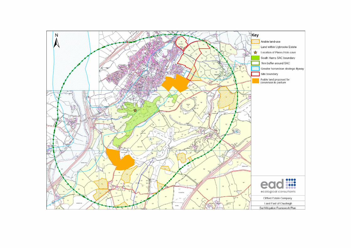
Figure 4: Strategic areas and sustenance zones for greater horseshoe bats from
Chudleigh Caves (part of South Hams SAC)
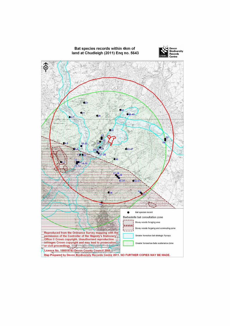
Figure 5: Chudleigh Caves bat features and sites
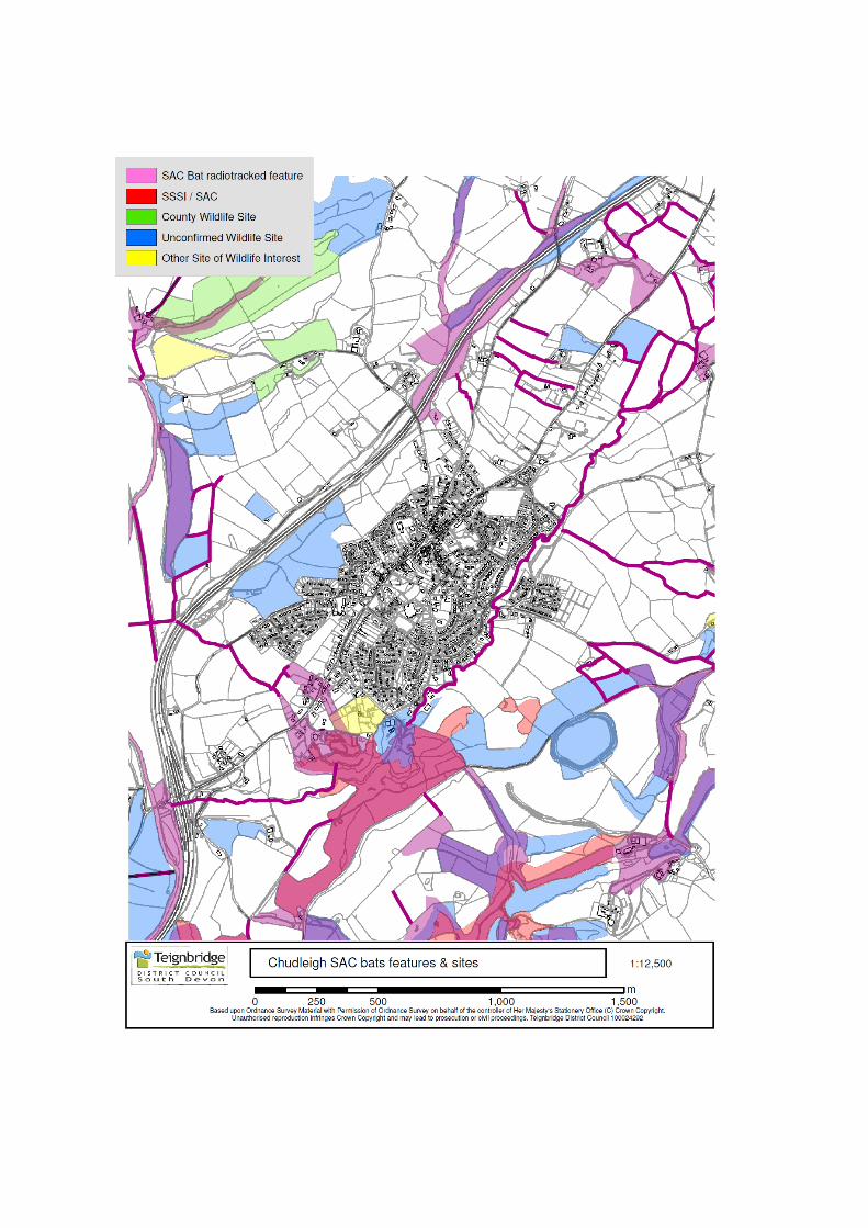

Figure 6: SAC Site-screening plan for development sites in and around Chudleigh
(Kestrel Wildlife Consultants, 2011)


Figure 7: Phase 1 Habitat Plan
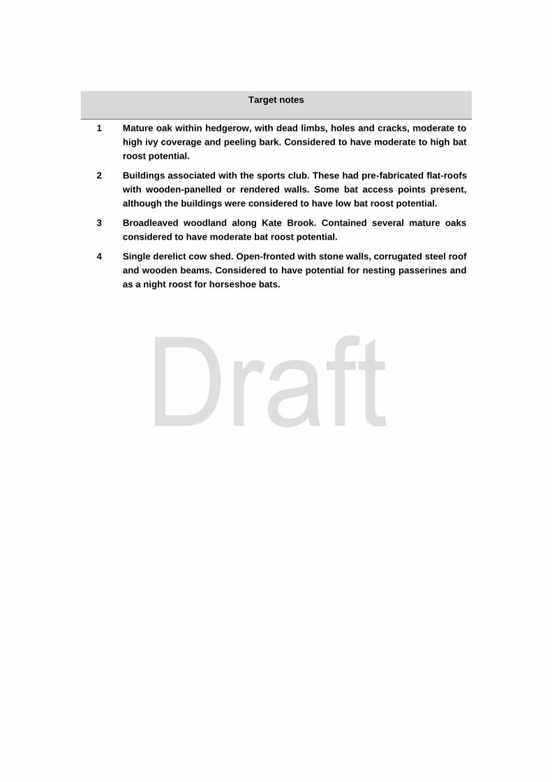
Target notes
1 Mature oak within hedgerow, with dead limbs, holes and cracks, moderate to
high ivy coverage and peeling bark. Considered to have moderate to high bat
roost potential.
2 Buildings associated with the sports club. These had pre-fabricated flat-roofs
with wooden-panelled or rendered walls. Some bat access points present,
although the buildings were considered to have low bat roost potential.
3 Broadleaved woodland along Kate Brook. Contained several mature oaks
considered to have moderate bat roost potential.
4 Single derelict cow shed. Open-fronted with stone walls, corrugated steel roof
and wooden beams. Considered to have potential for nesting passerines and
as a night roost for horseshoe bats.
Appendix 1: Species legislation and conservation status
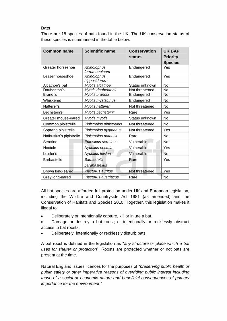
Bats
There are 18 species of bats found in the UK. The UK conservation status of
these species is summarised in the table below:
Common name Scientific name Conservation
status
UK BAP
Priority
Species Greater horseshoe Rhinolophus
ferrumequinum Endangered Yes
Lesser horseshoe Rhinolophus hipposideros
Endangered Yes
Alcathoe's bat Myotis alcathoe Status unknown No
Daubenton’s Myotis daubentonii Not threatened No
Brandt’s Myotis brandtii Endangered No
Whiskered Myotis mystacinus Endangered No
Natterer’s Myotis nattereri Not threatened No
Bechstein’s Myotis bechsteinii Rare Yes
Greater mouse-eared Myotis myotis Status unknown No
Common pipistrelle Pipistrellus pipistrellus Not threatened No
Soprano pipistrelle Pipistrellus pygmaeus Not threatened Yes
Nathusius’s pipistrelle Pipistrellus nathusii Rare No
Serotine Eptesicus serotinus Vulnerable No
Noctule Nyctalus noctula Vulnerable Yes
Leisler’s Nyctalus leisleri Vulnerable No
Barbastelle Barbastella
barabastellus
Rare Yes
Brown long-eared Plectorus auritus Not threatened Yes
Grey long-eared Plectorus austriacus Rare No
All bat species are afforded full protection under UK and European legislation,
including the Wildlife and Countryside Act 1981 (as amended) and the
Conservation of Habitats and Species 2010. Together, this legislation makes it
illegal to:
Deliberately or intentionally capture, kill or injure a bat.
Damage or destroy a bat roost; or intentionally or recklessly obstruct
access to bat roosts.
Deliberately, intentionally or recklessly disturb bats.
A bat roost is defined in the legislation as “any structure or place which a bat
uses for shelter or protection”. Roosts are protected whether or not bats are
present at the time.
Natural England issues licences for the purposes of “preserving public health or
public safety or other imperative reasons of overriding public interest including
those of a social or economic nature and beneficial consequences of primary
importance for the environment.”

In every case a licence can not be granted unless:
“There is no satisfactory alternative”; and
“The action authorised will not be detrimental to the maintenance of
the population of bats at a favourable conservation status in their
natural range”


Appendix 4
Natural England Response to Draft Bat Mitigation Framework
1
Dear Matt, Re: Bat Mitigation Framework – May 2012 Location: Land east of Chudleigh
I write further to your email dated 31st May 2012 with a request for comments regarding the “Bat Mitigation Framework” you have prepared on behalf of Clifford Estate Company. Where relevant, and to inform surveying requirements, we recommend that survey methods are drafted and agreed in advance of the surveying season. Natural England is a non-departmental public body. Our statutory purpose is to ensure that the natural environment is conserved, enhanced, and managed for the benefit of present and future generations, thereby contributing to sustainable development. Following the order of the bullet points provided in your document, I provide specific advice below based upon best practice guidance:-
1.3.2 – Review of existing information: Section 4.3.3 of the BCT Guidelines (2012) recommends that the geographical extent of pre-survey data search “If there are designated sites such as SACs or SSSIs within 10km of the proposed development site, or if the extent or potential impact of the proposed works is especially high, all information should be requested from up to 10km away from the site.”
1.3.3 – Extended Phase 1 Habitat Survey: Although not necessarily directly relevant to greater horseshoe bat interest, we point out that there are limitations to botanical survey information gained in winter.
The off-site mitigation strategy should also consider that the proposed development area is a single block of land, providing a degree of buffering from adjacent land. Disparate off-site fields will
Date: 19th June 2012 Our ref: 55343 Your ref: bat mitigation framework
Matt Jones EAD Ltd 3 Colleton Crescent Exeter Devon, EX2 4DG
Natural England
Consultation Service
Hornbeam House
Electra Way
Crewe Business Park
CREWE
CW1 6GJ
T: 0300 060 3900
2
have to be assessed in comparison to one block of land. The off-site mitigation should also consider value of species diverse swards to increase the biodiversity value and invertebrate interest.
Further, a Construction Environmental Management Plan (CEMP) would be required to manage the potential construction phase. In addition, all mitigation should be delivered and secured in perpetuity to reflect the permanent impacts associated with the proposed development.
We welcome your request for input at this stage as this will ensure that any matters can be addressed in good time in advance of any potential planning application. Other than the comments provided above we consider that the principles put forward in your document are sound and provide a good framework. Further, it will be important to ensure that other issues regarding biodiversity, protected species, landscape, and green infrastructure are also integrated into the proposals. For any correspondence or queries relating to this consultation only, please contact me at Renslade House, Level 10, Bonhay Road, Exeter, EX4 3AW, or using my email provided below, or my direct telephone line on 0300 060 0456. For all other correspondence, please contact the address above or our Consultation Hub email below. Regards,
Julien
Julien Sclater
Lead Adviser
Land Use Team
Please note that all consultation with Natural England should be sent to our Consultation Hub at [email protected] or sent to the address at the top of this letter Cc: Mary Rush (TDC); Stephen Carroll (TDC); Jonny Miller (TDC/TCCT); Nick Matthews (Savills); Darren Summerfield (TDC); Mike Pennington (Savills)

Appendix 5
Correspondence between the Highways consultant and the Highways Authority
FMW Consultancy Ltdc
1
Nick Matthews
Subject: FW: Potential development of Land East of ChudleighAttachments: FMW0726 - SK02 Rev B - Site Access Option A - Clifford Street.pdf
From: Chris Miles [mailto:[email protected]] Sent: 10 September 2012 09:48 To: Dan Yeates Subject: FW: Potential development of Land East of Chudleigh Dan, Please see below full and final confirmation from the highway officer regarding access to the above site. For completeness I attach the final agreed plan as well. Regards Chris Miles Director FMW Consultancy Ltd T: 0117 9596464 M: 07912 444460
From: Richard Jackson [mailto:[email protected]] Sent: 06 September 2012 18:43 To: Chris Miles Cc: Sarah Ratnage Subject: RE: Potential development of Land East of Chudleigh Dear Chris, In terms of access visibility the shown splay is in principle acceptable as long as it is at 600mm height and no greater, this can be demonstrated using cross sections when a planning submission is made. Subject to capacity assessments showing a simple priority arrangement is acceptable and the caveats mentioned, I can confirm I am happy. For your information I should also mention that from the 23rd of September there will be a new Teignbridge Highways Development Management Officer. Sarah Ratnage has been appointed as the new Officer for the area so I have copied her into this latest correspondence. Kind Regards, Richard Jackson Highways Development Management Officer (01392) 380176
From: Chris Miles [mailto:[email protected]] Sent: Thu 06/09/2012 17:29 To: Richard Jackson Subject: FW: Potential development of Land East of Chudleigh
Richard,
Further to our previous email exchanges below, please find attached a revised site access arrangement that has been amended to identify the visibility splays required based on the 85th %ile speed of traffic past the proposed access location. From our previous dialogue I believe you would be happy with this arrangement to serve a development of approximately 150 residential units. Your confirmation of this would be greatly appreciated.
2
The caveat to the above is that the proposed bridge would need to be approved by the Council’s structural design team, be acceptable to the Environment Agency in terms of flooding/drainage implications and also be acceptable to the Town Council in terms of use of the land required.
Any questions please call.
Regards
Chris Miles
Director
FMW Consultancy Ltd
T: 0117 9596464
M: 07912 444460