Technical Report Seriescgwb.gov.in/District_Profile/TamilNadu/Thoothukudi.pdfAWARENESS AND TRAINING...
21
DISTRICT GROUNDWATER BROCHURE THOOTHUKUDI DISTRICT, TAMIL NADU A.BALACHANDRAN, SCIENTIST-D Government of India Ministry of Water Resources C C e e n n t t r r a a l l G G r r o o u u n n d d W W a a t t e e r r B B o o a a r r d d South Eastern Coastal Region Chennai March 2009 F F o o r r o o f f f f i i c c i i a a l l u u s s e e T e ec h hni c ca l l R e ep o o r rt S Seri e e s s
Transcript of Technical Report Seriescgwb.gov.in/District_Profile/TamilNadu/Thoothukudi.pdfAWARENESS AND TRAINING...
DDIISSTTRRIICCTT GGRROOUUNNDDWWAATTEERR BBRROOCCHHUURREE
TTHHOOOOTTHHUUKKUUDDII DDIISSTTRRIICCTT,, TTAAMMIILL NNAADDUU
A.BALACHANDRAN, SCIENTIST-D
GGoovveerrnnmmeenntt ooff IInnddiiaa
MMiinniissttrryy ooff WWaatteerr RReessoouurrcceess
CCeennttrraall GGrroouunndd WWaatteerr BBooaarrdd SSoouutthh EEaasstteerrnn CCooaassttaall RReeggiioonn
CChheennnnaaii
March 2009
FFoorr ooffffiicciiaall uussee
TTeecchhnniiccaall RReeppoorrtt SSeerriieess
1
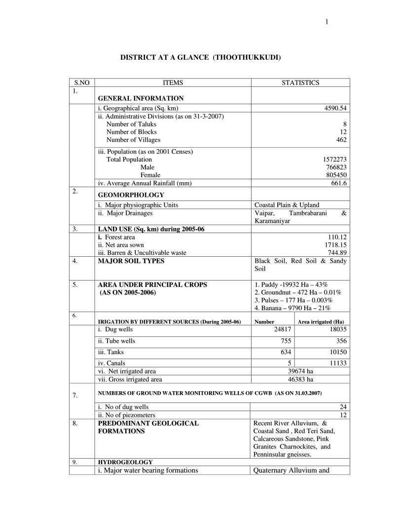
DISTRICT AT A GLANCE (THOOTHUKKUDI)
SS..NNOO IITTEEMMSS SSTTAATTIISSTTIICCSS
11.. GENERAL INFORMATION
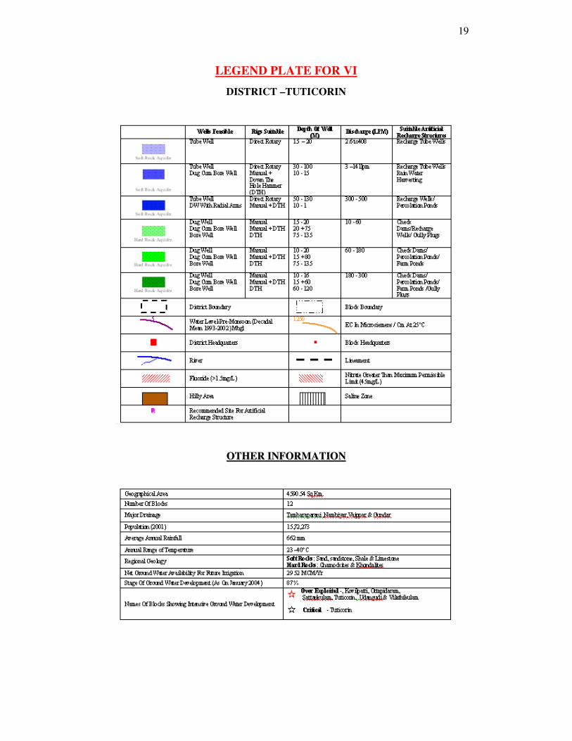
ii.. GGeeooggrraapphhiiccaall aarreeaa ((SSqq.. kkmm)) 44559900..5544
iiii.. AAddmmiinniissttrraattiivvee DDiivviissiioonnss ((aass oonn 3311--33--22000077))
NNuummbbeerr ooff TTaalluukkss
NNuummbbeerr ooff BBlloocckkss
NNuummbbeerr ooff VViillllaaggeess
88
1122
446622
iiiiii.. PPooppuullaattiioonn ((aass oonn 22000011 CCeennsseess))
TToottaall PPooppuullaattiioonn
MMaallee
FFeemmaallee
11557722227733
776666882233
880055445500
iivv.. AAvveerraaggee AAnnnnuuaall RRaaiinnffaallll ((mmmm)) 666611..66
GEOMORPHOLOGY
ii.. MMaajjoorr pphhyyssiiooggrraapphhiicc UUnniittss CCooaassttaall PPllaaiinn && UUppllaanndd
22..
iiii.. MMaajjoorr DDrraaiinnaaggeess VVaaiippaarr,, TTaammbbrraabbaarraannii &&
KKaarraammaanniiyyaarr
33.. LLAANNDD UUSSEE ((SSqq.. kkmm)) dduurriinngg 22000055--0066
ii.. FFoorreesstt aarreeaa
iiii.. NNeett aarreeaa ssoowwnn
iiiiii.. BBaarrrreenn && UUnnccuullttiivvaabbllee wwaassttee
111100..1122
11771188..1155
774444..8899
44.. MMAAJJOORR SSOOIILL TTYYPPEESS BBllaacckk SSooiill,, RReedd SSooiill && SSaannddyy
SSooiill
55.. AARREEAA UUNNDDEERR PPRRIINNCCIIPPAALL CCRROOPPSS
((AASS OONN 22000055--22000066)) 11.. PPaaddddyy --1199993322 HHaa –– 4433%%
22.. GGrroouunnddnnuutt –– 447722 HHaa –– 00..0011%%
33.. PPuullsseess –– 117777 HHaa –– 00..000033%%
44.. BBaannaannaa –– 99779900 HHaa –– 2211%% 66..
IIRRIIGGAATTIIOONN BBYY DDIIFFFFEERREENNTT SSOOUURRCCEESS ((DDuurriinngg 22000055--0066))
NNuummbbeerr
AArreeaa iirrrriiggaatteedd ((HHaa))
ii.. DDuugg wweellllss 2244881177 1188003355
iiii.. TTuubbee wweellllss 775555 335566
iiiiii.. TTaannkkss 663344 1100115500
iivv.. CCaannaallss 55 1111113333
vvii.. NNeett iirrrriiggaatteedd aarreeaa 3399667744 hhaa
vviiii.. GGrroossss iirrrriiggaatteedd aarreeaa 4466338833 hhaa
NNUUMMBBEERRSS OOFF GGRROOUUNNDD WWAATTEERR MMOONNIITTOORRIINNGG WWEELLLLSS OOFF CCGGWWBB ((AASS OONN 3311..0033..22000077))
ii.. NNoo ooff dduugg wweellllss 2244
77..
iiii.. NNoo ooff ppiieezzoommeetteerrss 1122
88.. PPRREEDDOOMMIINNAANNTT GGEEOOLLOOGGIICCAALL
FFOORRMMAATTIIOONNSS RReecceenntt RRiivveerr AAlllluuvviiuumm,, &&
CCooaassttaall SSaanndd ,, RReedd TTeerrii SSaanndd,,
CCaallccaarreeoouuss SSaannddssttoonnee,, PPiinnkk
GGrraanniitteess CChhaarrnnoocckkiitteess,, aanndd
PPeennnniinnssuullaarr ggnneeiisssseess..
99.. HHYYDDRROOGGEEOOLLOOGGYY
ii.. MMaajjoorr wwaatteerr bbeeaarriinngg ffoorrmmaattiioonnss QQuuaatteerrnnaarryy AAlllluuvviiuumm aanndd
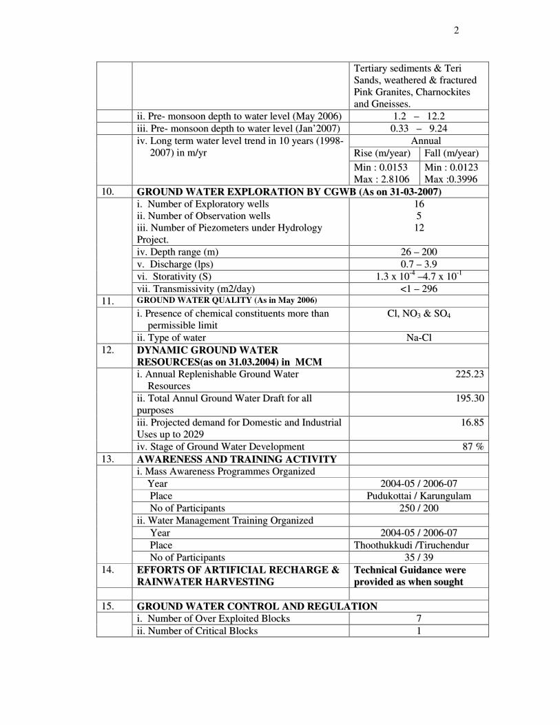
2
TTeerrttiiaarryy sseeddiimmeennttss && TTeerrii
SSaannddss,, wweeaatthheerreedd && ffrraaccttuurreedd
PPiinnkk GGrraanniitteess,, CChhaarrnnoocckkiitteess
aanndd GGnneeiisssseess..
iiii.. PPrree-- mmoonnssoooonn ddeepptthh ttoo wwaatteerr lleevveell ((MMaayy 22000066)) 11..22 –– 1122..22
iiiiii.. PPrree-- mmoonnssoooonn ddeepptthh ttoo wwaatteerr lleevveell ((JJaann’’22000077)) 00..3333 –– 99..2244
AAnnnnuuaall
RRiissee ((mm//yyeeaarr)) FFaallll ((mm//yyeeaarr)) iivv.. LLoonngg tteerrmm wwaatteerr lleevveell ttrreenndd iinn 1100 yyeeaarrss ((11999988--
22000077)) iinn mm//yyrr
MMiinn :: 00..00115533
MMaaxx :: 22..88110066 MMiinn :: 00..00112233
MMaaxx ::00..33999966
1100.. GGRROOUUNNDD WWAATTEERR EEXXPPLLOORRAATTIIOONN BBYY CCGGWWBB ((AAss oonn 3311--0033--22000077))
ii.. NNuummbbeerr ooff EExxpplloorraattoorryy wweellllss
iiii.. NNuummbbeerr ooff OObbsseerrvvaattiioonn wweellllss
iiiiii.. NNuummbbeerr ooff PPiieezzoommeetteerrss uunnddeerr HHyyddrroollooggyy
PPrroojjeecctt..
1166
55
1122
iivv.. DDeepptthh rraannggee ((mm)) 2266 –– 220000
vv.. DDiisscchhaarrggee ((llppss)) 00..77 –– 33..99
vvii.. SSttoorraattiivviittyy ((SS)) 11..33 xx 1100--44
––44..77 xx 1100--11
vviiii.. TTrraannssmmiissssiivviittyy ((mm22//ddaayy)) <<11 –– 229966
1111.. GROUND WATER QUALITY (As in May 2006)
ii.. PPrreesseennccee ooff cchheemmiiccaall ccoonnssttiittuueennttss mmoorree tthhaann
ppeerrmmiissssiibbllee lliimmiitt CCll,, NNOO33 && SSOO44
iiii.. TTyyppee ooff wwaatteerr NNaa--CCll
1122.. DDYYNNAAMMIICC GGRROOUUNNDD WWAATTEERR
RREESSOOUURRCCEESS((aass oonn 3311..0033..22000044)) iinn MMCCMM
ii.. AAnnnnuuaall RReepplleenniisshhaabbllee GGrroouunndd WWaatteerr
RReessoouurrcceess 222255..2233
iiii.. TToottaall AAnnnnuull GGrroouunndd WWaatteerr DDrraafftt ffoorr aallll
ppuurrppoosseess 119955..3300
iiiiii.. PPrroojjeecctteedd ddeemmaanndd ffoorr DDoommeessttiicc aanndd IInndduussttrriiaall
UUsseess uupp ttoo 22002299 1166..8855
iivv.. SSttaaggee ooff GGrroouunndd WWaatteerr DDeevveellooppmmeenntt 8877 %%
1133.. AAWWAARREENNEESSSS AANNDD TTRRAAIINNIINNGG AACCTTIIVVIITTYY
ii.. MMaassss AAwwaarreenneessss PPrrooggrraammmmeess OOrrggaanniizzeedd
YYeeaarr 22000044--0055 // 22000066--0077
PPllaaccee PPuudduukkoottttaaii // KKaarruunngguullaamm
NNoo ooff PPaarrttiicciippaannttss 225500 // 220000
iiii.. WWaatteerr MMaannaaggeemmeenntt TTrraaiinniinngg OOrrggaanniizzeedd
YYeeaarr 22000044--0055 // 22000066--0077
PPllaaccee TThhooootthhuukkkkuuddii //TTiirruucchheenndduurr
NNoo ooff PPaarrttiicciippaannttss 3355 // 3399
1144.. EEFFFFOORRTTSS OOFF AARRTTIIFFIICCIIAALL RREECCHHAARRGGEE &&
RRAAIINNWWAATTEERR HHAARRVVEESSTTIINNGG TTeecchhnniiccaall GGuuiiddaannccee wweerree
pprroovviiddeedd aass wwhheenn ssoouugghhtt
1155.. GGRROOUUNNDD WWAATTEERR CCOONNTTRROOLL AANNDD RREEGGUULLAATTIIOONN
ii.. NNuummbbeerr ooff OOvveerr EExxppllooiitteedd BBlloocckkss 77
iiii.. NNuummbbeerr ooff CCrriittiiccaall BBlloocckkss 11
3
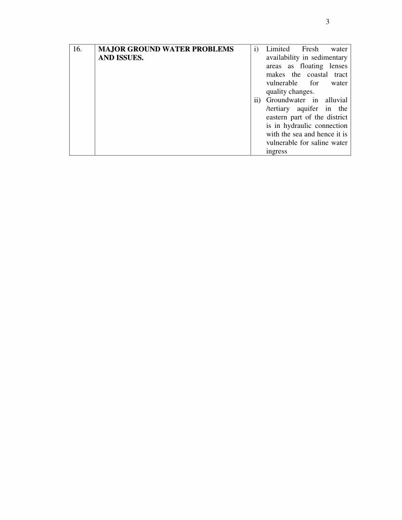
1166.. MMAAJJOORR GGRROOUUNNDD WWAATTEERR PPRROOBBLLEEMMSS
AANNDD IISSSSUUEESS..
i) Limited Fresh water
availability in sedimentary
areas as floating lenses
makes the coastal tract
vulnerable for water
quality changes.
iiii)) Groundwater in alluvial
/tertiary aquifer in the
eastern part of the district
is in hydraulic connection
with the sea and hence it is
vulnerable for saline water
ingress
4
11..00 IINNTTRROODDUUCCTTIIOONN
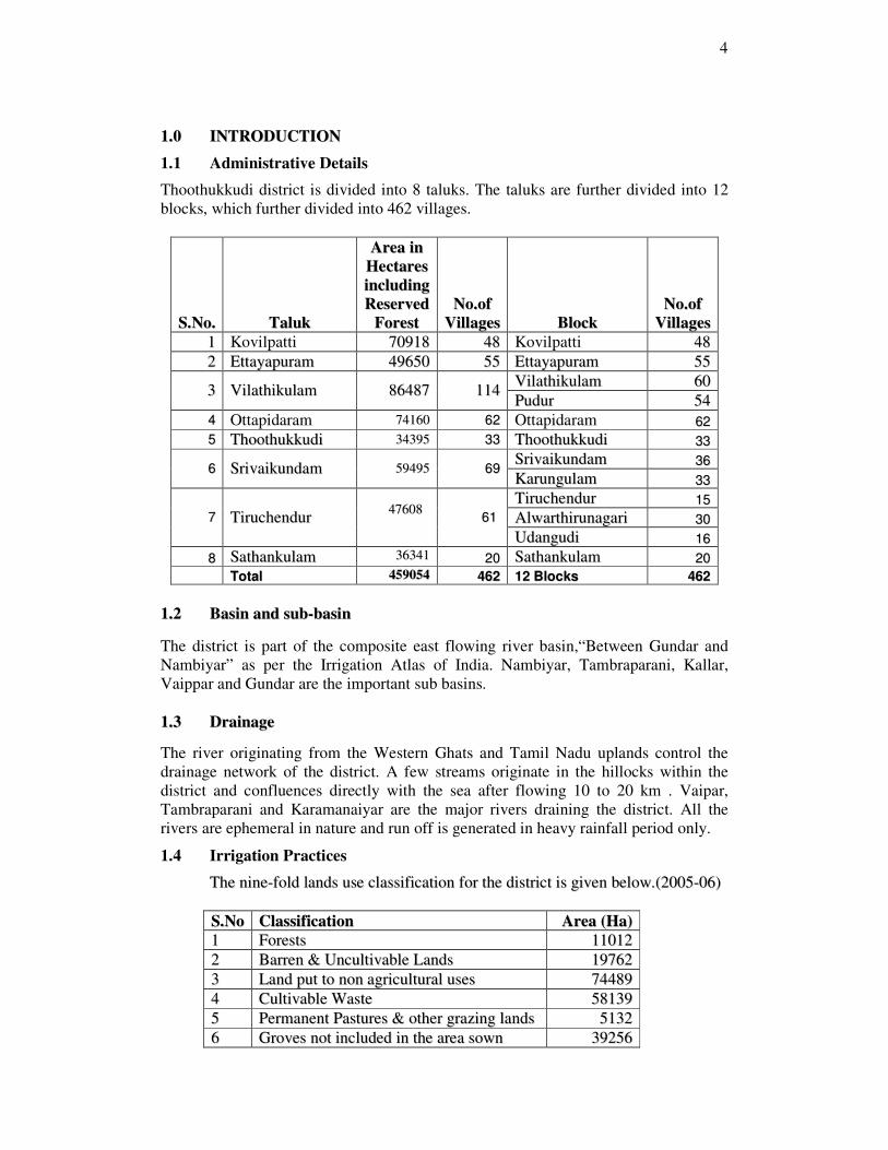
1.1 Administrative Details
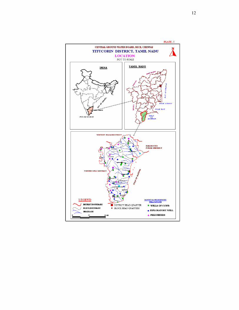
Thoothukkudi district is divided into 8 taluks. The taluks are further divided into 12
blocks, which further divided into 462 villages.
SS..NNoo.. TTaalluukk
AArreeaa iinn
HHeeccttaarreess
iinncclluuddiinngg
RReesseerrvveedd
FFoorreesstt NNoo..ooff
VViillllaaggeess BBlloocckk NNoo..ooff
VViillllaaggeess
11 Kovilpatti 7700991188 4488 Kovilpatti 4488
22 EEttttaayyaappuurraamm 4499665500 5555 EEttttaayyaappuurraamm 5555
VViillaatthhiikkuullaamm 6600 33 VViillaatthhiikkuullaamm 8866448877 111144
PPuudduurr 5544
44 Ottapidaram 7744116600 6622 Ottapidaram 6622
55 TThhooootthhuukkkkuuddii 3344339955 3333 TThhooootthhuukkkkuuddii 3333
SSrriivvaaiikkuunnddaamm 3366 66 SSrriivvaaiikkuunnddaamm 5599449955 6699
KKaarruunngguullaamm 3333
TTiirruucchheenndduurr 1155
AAllwwaarrtthhiirruunnaaggaarrii 3300 77 TTiirruucchheenndduurr 4477660088
6611
UUddaanngguuddii 1166
88 SSaatthhaannkkuullaamm 3366334411 2200 SSaatthhaannkkuullaamm 2200
TToottaall 445599005544 446622 1122 BBlloocckkss 446622
11..22 BBaassiinn aanndd ssuubb--bbaassiinn
The district is part of the composite east flowing river basin,“Between Gundar and
Nambiyar” as per the Irrigation Atlas of India. Nambiyar, Tambraparani, Kallar,
Vaippar and Gundar are the important sub basins.
11..33 DDrraaiinnaaggee
The river originating from the Western Ghats and Tamil Nadu uplands control the
drainage network of the district. A few streams originate in the hillocks within the
district and confluences directly with the sea after flowing 10 to 20 km . Vaipar,
Tambraparani and Karamanaiyar are the major rivers draining the district. All the
rivers are ephemeral in nature and run off is generated in heavy rainfall period only.
1.4 Irrigation Practices
TThhee nniinnee--ffoolldd llaannddss uussee ccllaassssiiffiiccaattiioonn ffoorr tthhee ddiissttrriicctt iiss ggiivveenn bbeellooww..((22000055--0066))
SS..NNoo CCllaassssiiffiiccaattiioonn AArreeaa ((HHaa))
11 FFoorreessttss 1111001122
22 BBaarrrreenn && UUnnccuullttiivvaabbllee LLaannddss 1199776622
33 LLaanndd ppuutt ttoo nnoonn aaggrriiccuullttuurraall uusseess 7744448899
44 CCuullttiivvaabbllee WWaassttee 5588113399
55 PPeerrmmaanneenntt PPaassttuurreess && ootthheerr ggrraazziinngg llaannddss 55113322
66 GGrroovveess nnoott iinncclluuddeedd iinn tthhee aarreeaa ssoowwnn 3399225566

5
SS..NNoo CCllaassssiiffiiccaattiioonn AArreeaa ((HHaa))
77 CCuurrrreenntt FFaalllloowwss 66669933
88 OOtthheerr FFaallllooww LLaannddss 7722775566
99 NNeett AArreeaa ssoowwnn 117711881155
TToottaall 445599005544
((SSoouurrccee:: DDeeppaarrttmmeenntt ooff EEccoonnoommiiccss && SSttaattiissttiiccss,, GGoovvtt.. ooff TTaammiill NNaadduu))
The chief irrigation sources in the area are the Canals, tanks, wells and tube/bore well,
irrigation is highest in Srivaikundam, Alwarthirunagari and Karungulam block
followed by Sathankulam, Ettayapuram, Tiruchendur, Udangudi, Thoothukkudi,
Kovilpatti, Vilathikulam, and Pudur blocks.
TThhee bblloocckk wwiissee aanndd ssoouurrccee wwiissee nneett aarreeaa iirrrriiggaatteedd iinn HHaa iiss ggiivveenn bbeellooww ((22000055--0066))..
NNeett aarreeaa iirrrriiggaatteedd bbyy SS..
NNoo BBlloocckk
CCaannaallss TTaannkkss TTuubbee//
bboorree
wweellllss
OOrrddiinnaarryy
wweellllss OOtthheerr
SSoouurrcceess
TToottaall NNeett
AArreeaa
iirrrriiggaatteedd
11 TThhooootthhuukkkkuuddii 00 998888 5511 773377 00 11777766
22 SSrriivvaaiikkuunnddaamm 22337733 44665511 6677 229911 00 77338822
33 KKaarruunngguullaamm 11445577 11001166 1155 22335555 00 44884433
44 TTiirruucchheenndduurr 22887777 00 00 220099 00 33008866
55 AAllwwaarrtthhiirruunnaaggaarrii 44442266 11113355 22 887733 00 66443366
66 UUddaanngguuddii 00 00 1199 22999911 00 33001100
77 SSaatthhaannkkuullaamm 00 449999 1188 33119933 00 33771100
88 OOttttaappiiddaarraamm 00 226677 1100 11660088 00 11888855
99 EEttttaayyaappuurraamm 00 779900 00 22555599 00 33334499
1100 KKoovviillppaattttii 00 440055 00 11333344 00 11773399
1111 VViillaatthhiikkuullaamm 00 223366 116655 11220033 00 11660044
1122 PPuudduurr 00 116633 99 668822 00 885544
TToottaall 1111113333 99998877 334477 1177335533 00 3388882200
((SSoouurrccee:: DDeeppaarrttmmeenntt ooff EEccoonnoommiiccss && SSttaattiissttiiccss,, GGoovvtt.. ooff TTaammiill NNaadduu))
1.5 Studies/Activities carried out by CGWB
Central Ground Water Board carried out the Systematic hydrogelogical surveys in the
district during the period of 1976 - 80, Reappraisal hydrogelogical surveys were
conducted during the period of 1990-93. Detailed exploration were carried out in
Vaipar and Gundar basin down to a depth of26 to 200 m bgl to assess the ground
water resources of the area during 1994 - 95.
CGWB is monitoring the groundwater regime for the changes in water level and water
quality through 24 dug wells and 12 piezometers. The monitoring of water levels are
carried out during May (Pre monsoon), August (Middle of south west monsoon),
November (post south west monsoon & initial stage of north east monsoon) &
January (Post North east monsoon) to study the impact of rainfall on groundwater
regime. Water samples are collected during May for determining the changes in
chemical quality of groundwater.
6
2.0 RAINFALL AND CLIMATE
The district receives the rain under the influence of both southwest and northeast
monsoons. The northeast monsoon chiefly contributes to the rainfall in the district.
Most of the precipitation occurs in the form of cyclonic storms caused due to the
depressions in Bay of Bengal. The southwest monsoon rainfall is highly erratic and
summer rains are negligible. Rainfall data from seven stations over the period 1901-
2001 were utilised and a perusal of the data shows that the normal annual rainfall over
the district varies from about 570 mm to 740 mm.It is the minimum around Arasadi
(577.4 mm) and Thoothukkudi (582.8 mm) in the central eastern part of the district. It
gradually increases towards south, west and north and attains a maximum around
Kayattar (722.5 mm) and Kovilpatti (734.8 mm) in the northwestern part..
The district enjoys a hot tropical climate. The high relative humidity prevail through
out the year between 60 and 75%.
The annual mean minimum and maximum temperature are 23°C and 29°C
respectively.
3.0 GEOMORPHOLOGY AND SOIL TYPES
3.1 Geomorphology
The prominent geomorphic units identified in the district are 1) Fluvial, 2) Marine, 3)
Fluvio-marine, 4) Aeolian and 5) Erosional landforms depending on the environment
of formation. Taruvaikulam- Tuticorin surface, Kulattur surface, Vaippar
surface,Nagalapuram-Vedanattham surface and Volinokkam-Vembar surface are
some of the erosional geomorphic units in the northern part of the district.
Karamaniyar surface, Tambraparni surface, Tiruchendur-Kayapattinam surface and
Vallanadu surface are the geomorphic units in the southern part of the district.
The number of red sandy tracts formed of the sand dunes locally known as Teri sand
complex are the important feature in the coast. These Teri sands extend in width from
6 to 8 km from the coast. Adaippanvilai Teri, Kudiraimozhi teri and Vaippar-Vembar
Teri are some of the important Teri areas, which are having elevation in the range of
15 to 62m above MSL.
33..22 SSooiillss
The district is covered by Black Cotton soil in the west with isolated red soil patches
in high ground. The sandy soil is present in the coastal tract. Alluvial soil is restricted
to river flood plain and coastal part. Alkaline and saline soils are also noticed at
places.
4.0 GROUND WATER SCENARIO
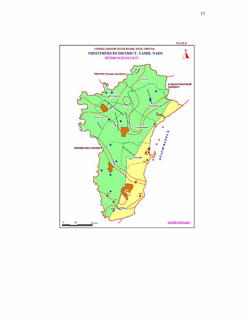
44..11 HHyyddrrooggeeoollooggyy
The district is underlain by both porous and fissured formations. . The important
aquifer systems in the district are constituted by i) unconsolidated & semi-
consolidated formations and ii) weathered and fractured crystalline rocks
The porous formations in the district include sandstones and clays of Recent to
7
subrecent and Tertiary age (Quaternary). The Recent formations comprising mainly
sands, clays and gravels are confined to major drainage courses in the district. The
maximum thickness of alluvium is 45.0 m bgl, whereas the average thickness is about
25.0 m. Ground water occurs under water table and confined conditions in these
formations and is being developed by means of dug wells and filter points. The
productive zones are encountered in the depth range of 29.5 to 62 m bgl. Alluvium,
which forms a good aquifer system along the Vaippar and Gundar river bed which is
one of the major sources of water supply to the villages
The water-bearing properties of crystalline formations which lack primary porosity
depend on the extent of development of secondary intergranular porosity. The
occurrence and movement of ground water in these rocks are under unconfined
conditions in the joints & fissures and dependent on the nature and extent of pores and
interconnection of fractures zones. The morpho-tectonic analysis of the crystalline
tract indicates the presence of deep seated tensile and shear fractures particularly
along the fold axes. These tension joints and fractures and shear fractures at deeper
depth of 30 to 100 m have been acting as conduits for ground water movement.
The depth of the wells in crystalline rocks ranged from 10.00 to 15.00 m bgl. The
yield of large diameter wells in the district, tapping the weathered mantle of
crystalline rocks ranges from 40 to 110 lpm and are able to sustain pumping for 2 to 6
hours per day. The Specific capacity of large diameter wells tested in crystalline
rocks ranges from 3.0 to 141 lpm/m. of drawdown. The yield characteristics of wells
vary considerably depending on the topographic set-up, lithology and nature of
weathering.
The depth of wells drilled in crystalline rocks ranged from 26 to 200 m bgl various
state agencies mainly for domestic purposes and the yield wells ranged from 10 to 250
lpm. The yield of successful bore wells drilled down to a depth of 750 m bgl during
the ground water exploration programme of Central Ground Water Board ranged from
3 to 10 lpm. The aquifer and well parameters of the wells show wide variation, both
in crystalline and sedimentary formations.
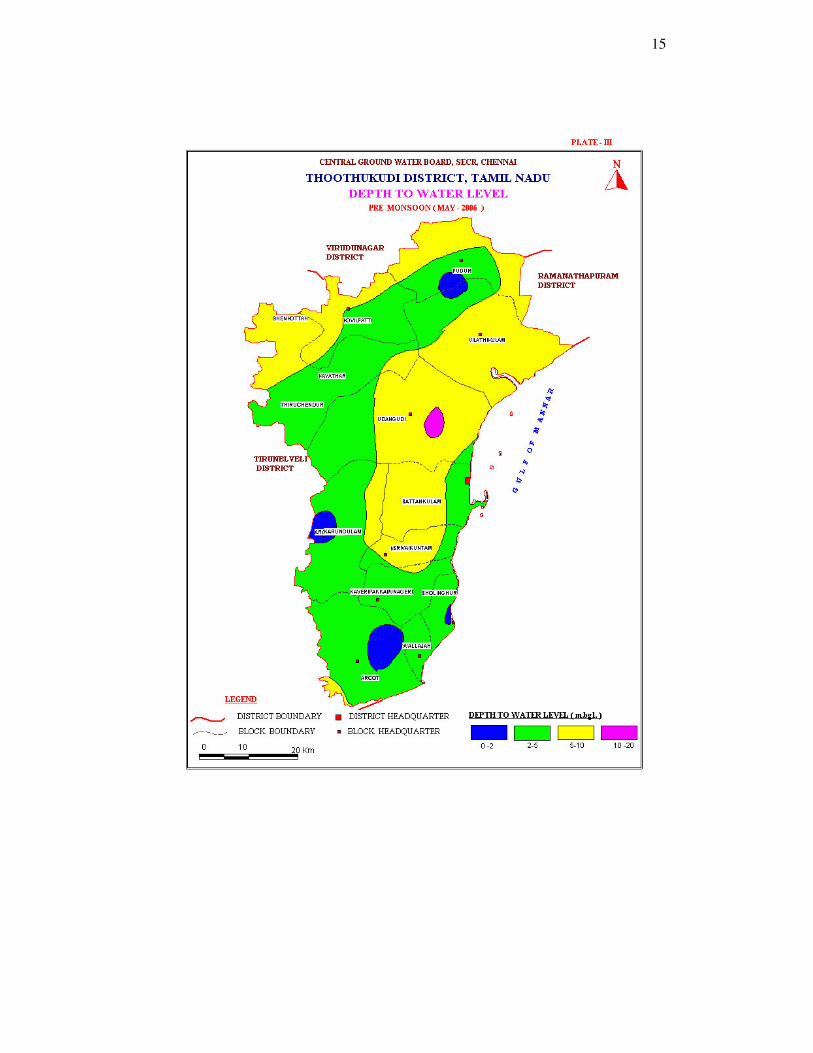
The depth to water level in the district varied between 1.20 – 12.12 m bgl during pre-
monsoon (May 2006) and varied between 0.33 – 9.24 m bgl during post monsoon
(Jan 2007). The seasonal fluctuation shows a rise in water level, which ranges from
0.20 to 8.41 m bgl. The piezometric head varied between 2.40 to 11.00 bgl during pre
monsoon (May 2006) and 0.33 to 9.24 m bgl during post monsoon (Jan 2007).
44..11..11 LLoonngg TTeerrmm FFlluuccttuuaattiioonn ((11999988--22000077))
The long term water level fluctuation for the period 1998-2007 indicates rise in water
level in the area 0.0153 – 2.8106 m/year and fall in water level ranging between
0.0123 - 0.3996 m/year.
44..11..22 AAqquuiiffeerr PPaarraammeetteerr
Formation TTrraannssmmiissssiivviittyy
((mm22//ddaayy))
SSttoorraattiivviittyy SSppeecciiffiicc
YYiieelldd ((%%))
WWeeaatthheerreedd CCrryyssttaalllliinneess - -- <<22%%
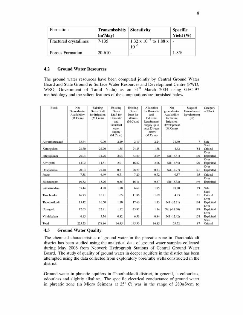
8
Formation TTrraannssmmiissssiivviittyy
((mm22//ddaayy))
SSttoorraattiivviittyy SSppeecciiffiicc
YYiieelldd ((%%))
FFrraaccttuurreedd ccrryyssttaalllliinneess 77--113355 11..3322 xx 1100 --33
ttoo 11..8888 xx
1100 --33
--
PPoorroouuss FFoorrmmaattiioonn 2200--661100 -- 11--88%%
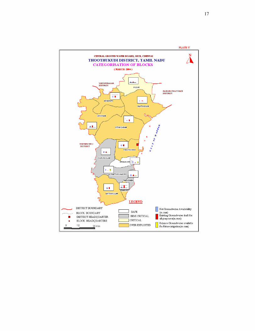
44..22 GGrroouunndd WWaatteerr RReessoouurrcceess
The ground water resources have been computed jointly by Central Ground Water
Board and State Ground & Surface Water Resources and Development Centre (PWD,
WRO, Government of Tamil Nadu) as on 31st March 2004 using GEC-97
methodology and the salient features of the computations are furnished below.
BBlloocckk NNeett
GGrroouunnddwwaatteerr
AAvvaaiillaabbiilliittyy
((MM..CCuu..mm))
EExxiissttiinngg
GGrroossss DDrraafftt
ffoorr IIrrrriiggaattiioonn
((MM..CCuu..mm))
EExxiissttiinngg
GGrroossss
DDrraafftt ffoorr
DDoommeessttiicc
aanndd
iinndduussttrriiaall
wwaatteerr
ssuuppppllyy
((MM..CCuu..mm))
EExxiissttiinngg
GGrroossss
DDrraafftt ffoorr
aallll uusseess
((MM..CCuu..mm))
AAllllooccaattiioonn
ffoorr DDoommeessttiicc
aanndd
IInndduussttrriiaall
RReeqquuiirreemmeenntt
ssuuppppllyy uupp ttoo
nneexxtt 2255 yyeeaarrss
((22002299))
((MM..CCuu..mm))
NNeett
ggrroouunnddwwaatteerr
AAvvaaiillaabbiilliittyy
ffoorr ffuuttuurree
IIrrrriiggaattiioonn
DDeevveellooppmmeenntt
((MM..CCuu..mm))
SSttaaggee ooff
GGrroouunnddwwaatteerr
DDeevveellooppmmeenntt
((%%))
CCaatteeggoorryy
ooff BBlloocckk
AAllwwaarrtthhiirruunnaaggaarrii 3333..6644 00..0000 22..1199 22..1199 22..2244 3311..4400 77 SSaaffee
KKaarruunngguullaamm 2288..7700 2222..9900 11..3355 2244..2255 11..3388 44..4422 8844 SSeemmii
CCrriittiiccaall
EEttttaayyaappuurraamm 2266..0044 3311..7766 22..0044 3333..8800 22..0099 NNiill ((--77..8811)) 113300 OOvveerr
EExxppllooiitteedd
KKoovviillppaattttii 1144..0022 1144..8811 22..0011 1166..8822 22..0066 NNiill ((--22..8855)) 112200 OOvveerr
EExxppllooiitteedd
OOttttaappiiddaarraamm 2200..0033 2277..4488 00..8811 2288..2299 00..8833 NNiill ((--88..2277)) 114411 OOvveerr
EExxppllooiitteedd
PPuudduurr 77..5588 66..4499 00..7711 77..2200 00..7722 00..3377 9955 CCrriittiiccaall
SSaatthhaannkkuullaamm 1100..8822 1155..2266 00..8855 1166..1111 00..8877 NNiill ((--55..3322)) 114499 OOvveerr
EExxppllooiitteedd
SSrriivvaaiikkuunnddaamm 3355..4444 44..8888 11..8800 66..6699 11..8855 2288..7700 1199 SSaaffee
TTiirruucchheenndduurr 1166..7733 1100..2211 11..6655 1111..8866 11..6699 44..8833 7711 SSeemmii
CCrriittiiccaall
TThhooootthhuukkkkuuddii 1155..4422 1166..5500 11..1100 1177..6600 11..1133 NNiill ((--22..2211)) 111144 OOvveerr
EExxppllooiitteedd
UUddaanngguuddii 1122..6655 2222..8811 11..1122 2233..9933 11..1144 NNiill ((--1111..3300)) 118899 OOvveerr
EExxppllooiitteedd
VViilltttthhiikkuullaamm 44..1155 55..7744 00..8822 66..5566 00..8844 NNiill ((--22..4422)) 115588 OOvveerr
EExxppllooiitteedd
TToottaall 222255..2233 117788..8866 1166..4455 119955..3300 1166..8855 2299..5522 8877 SSeemmii
CCrriittiiccaall
4.3 Ground Water Quality
The chemical characteristics of ground water in the phreatic zone in Thoothukkudi
district has been studied using the analytical data of ground water samples collected
during May 2006 from Network Hydrograph Stations of Central Ground Water
Board. The study of quality of ground water in deeper aquifers in the district has been
attempted using the data collected from exploratory bore/tube wells constructed in the
district.
Ground water in phreatic aquifers in Thoothukkudi district, in general, is colourless,
odourless and slightly alkaline. The specific electrical conductance of ground water
in phreatic zone (in Micro Seimens at 25o
C) was in the range of 280µS/cm to
9
12020µS/cm in the district and major parts are having multiplayer aquifer system.
Hence the water quality varies with respect to depth of taping.
It is observed that the 50 percent samples of ground water is suitable for drinking and
domestic uses but depth of the well should be properly designed, depending on the
multilayer aquifer system.
With regard to irrigation suitability based on specific electrical conductance and
Sodium Adsorption Ratio (SAR), it is observed that ground water in the phreatic zone
may cause high to very high salinity hazard and medium to high alkali hazard when
used for irrigation. Proper soil management strategies are to be adopted in the major
part of the district while using ground water for irrigation.
4.4 Status of Ground Water Development
The estimation of groundwater resources for the district has categorized the blocks as
given below.
Over Exploited – 7
Critical – 1
Semi Crtical – 2
Safe – 2
The shallow alluvial aquifers along Vaippar and Gundar rivers serve as an important
source of drinking water irrigation development for Thoothukkudi district. Dug wells
are the most common ground water abstraction structures used for irrigation in the
district. The yield of dug wells range from <50 to 200 m3/day in weathered
crystalline rocks, 20 to 100 m3/day in Tertiary formations and up to 400 m3/day in
Recent alluvial formations along major drainage courses.
5.0 Groundwater Management Strategy
5.1 Groundwater Development
In view of the comparatively high level of ground water development in the major
part of the district and the quality problems due to lithogenic and anthropogenic
factors, it is necessary to exercise caution while planning further development of
available ground water resources in the district.
The yields of dug wells in crystalline and Tertiary formations are improved at
favorable locations by construction of extension bores which are 20 to 40m. deep. In
recent years, a large number of bore wells have also been drilled by farmers for
irrigation purposes.
The development of ground water for irrigation in the district is mainly through dug
wells tapping the weathered residuum or recent alluvial deposits. Bore wells have
also become popular as the source for irrigation in the district in recent years. Dug
wells with extension bores wherever necessary is ideal for hard rock areas whereas
large diameter dug wells with radials is suitable for alluvial areas.
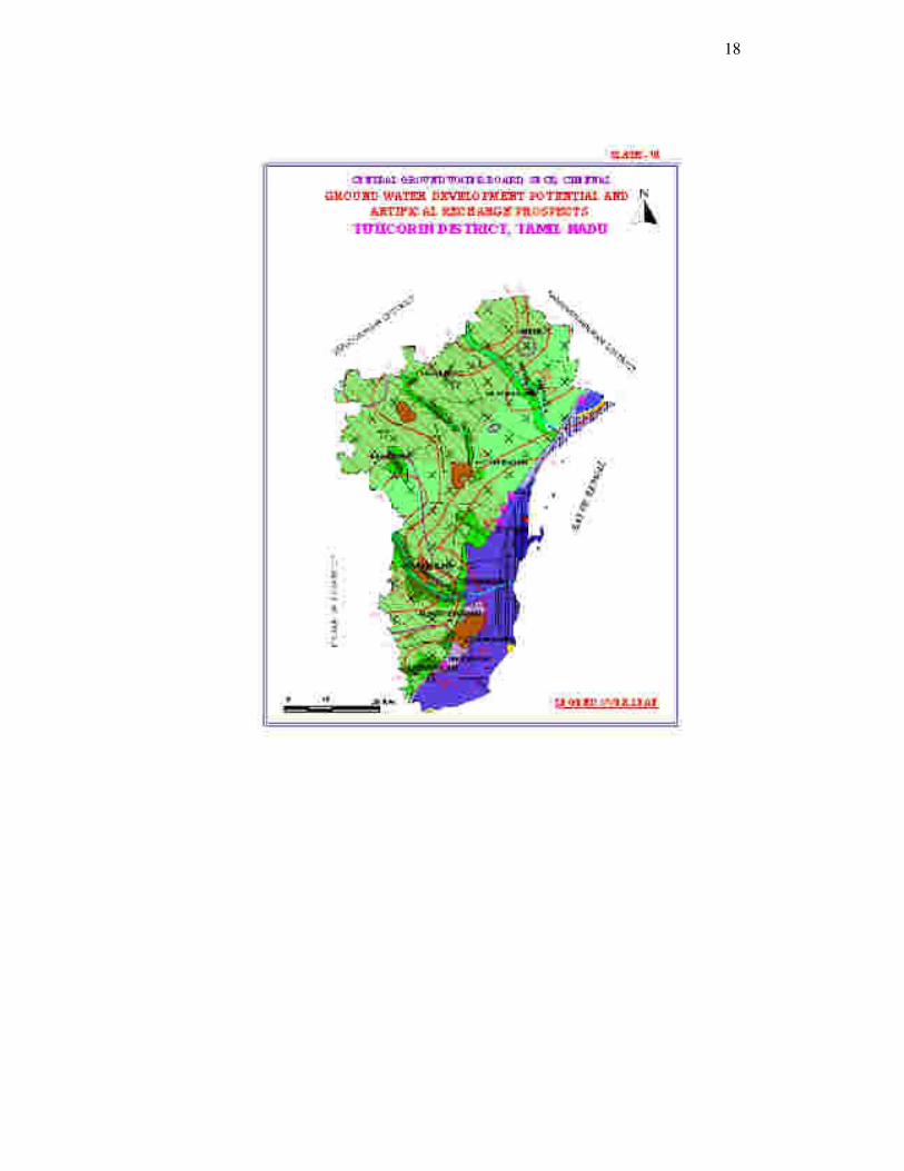
TThhee mmaapp sshhoowwiinngg tthhee ddeevveellooppmmeenntt pprroossppeeccttss ffoorr tthhee ddiissttrriicctt iiss sshhoowwnn iinn PPllaattee VVII..
10
5.2 Water Conservation and Artificial Recharge
CGWB had prepared a master plan to augment groundwater potential by saturating
the shallow aquifer taking into consideration the available unsaturated space during
post monsoon and available uncommitted surplus run off. Subsequently, computations
have been made for Drought Prone Area Programme (DPAP) for over exploited and
critical blocks in the districts warranting immediate attention. Institute of Remote
Sensing, Anna University had prepared block wise maps demarcating potential zones
for artificial recharge for the State of Tamil Nadu. Subsequently, State Government
agencies have constructed artificial recharge structures with their own fund or with
fund from Central Government, dovetailing various government programmes.
Ministry of Water Resources, Government of India has initiated Dug Well Recharge
Scheme in the State. The scheme is being implemented by the Nodal Department
(SG&SWRDC, PWD, WRO, Government of Tamil Nadu) with the technical
guidance of CGWB. The subsidy of Rs4000/- for small and marginal farmers and
Rs2000/- for the other farmers is credited to the beneficiaries’ bank account through
NABARD. The scheme after implementation will prove to be beneficial to the
irrigation sector. The available uncommitted surplus run off has to be recomputed,
taking into consideration the quantum of recharge effected through existing irrigation
dug wells also. The existing structures and uncommitted surplus flow should be
considered for further planning of artificial recharge programme.
On the basis of experimental studies, it has been found that desilting of existing tanks
followed by percolation pond with recharge wells, recharge shafts are economical.
There is considerable scope for implementation of roof – top rainwater harvesting in
the district. Recharge pits / Shafts / trenches of suitable design are ideal structures for
rainwater harvesting in such areas. Central Ground Water Board is also providing
free technical guidance for implementation of rooftop rainwater harvesting schemes.
6.0 Groundwater related Issues & Problems
Ground water development in this district is mainly by means of dug wells and hand
pumps. The shallow tube wells and dug cum bore wells in Panamparai Sandstone
area has increased the agricultural activities locally. The district needs careful
management practices in view of the vulnerable seawater intrusion problems and
limited scope for artificial recharge schemes in saline tracts of the district.
Water Supply: Ground water development in hard rocks are mainly by means of dug
wells and bore wells for irrigation and water supply respectively. Many bore wells are
given low yield and are suitable for hand pump only. The irrigation dug wells are in
better use. The urban water supply is mainly from the Tambraparni river and supply
depends on the saturation of river bed. Scarcity is common in many towns.
Based on the limited fresh water availability in sedimentary areas as floating lenses, it
is inferred that a major part of the coastal tract with Teri sands could be considered
vulnerable to water quality changes. A considerable amount of ground water is being
developed from the tube wells in the thin sedimentary zone in Surankudi area,
multiqualty aquifer in Tiruchendur area and Teri sands in Kudiraimoli Teri. As the
ground water in the alluvial/Tertiary aquifer in the eastern part of the district is in
11
hydraulic connection with the sea, the district is also vulnerable to saline water
ingress.
7.0 Awareness & Training Activity
7.1 Mass Awareness Campaign (MAP) & Water Management Training
Programme (WMTP) by CGWB
Two WMTP was organized on “Rain Water Harvesting Training” at the meeting hall
of District Collectorate complex, Thoothukkudi and Tiruchendur in Thoothukkudi
district during the period 2002-03 and 2006-07 respectivily. Two Mass Awareness
Campaign on “Ground Water Management, Regulation & Conservation” was
organized at Pudukottai and Karungulam in Thoothukkudi district during the period
2002-03 and 2006-07 respectivily.
8.0 Area Notified by CGWA/SGWA
Central Ground Water Authority has not notified any area in the district. Government
of Tamil Nadu vide G.O.No. 51 has restricted groundwater development for irrigation
in the over exploited blocks of Tamil Nadu. The over exploited blocks in this district
is Ettayapuram, Kovilpatti, Ottapidaram, Sathankulam, Thoothukkudi, Udangudi and
Viltthikulam
9.0 Recommendations
As the development of ground water has already reached an optimum stage in many
of the blocks of this district, further development of ground water for creation of
additional irrigation potential has to be carried out with extreme caution, considering
the poor sub-surface storage capacity.
Necessary measures for regulating the exploitation of ground water may be
implemented in coastal blocks of the district. The Teri sands and fresh water bearing
Tertiary sandstone area along the coast has to be notified as ground water sanctuaries
and further development has to be only for drinking water purposes. Roof top
harvesting and direct use from ground level storage is suggested for coastal
habitations including Tuticorin town so that the public water supply from distant
source can be managed in a better way. Modeling of coastal aquifer is needed for
various stress conditions in view of brine water and fresh water development in this
area.
Intensive monitoring of ground water levels and water quality is to be taken up in the
coastal areas of the district to monitor the movement of fresh water – saline water
interface.
Artificial recharge of ground water through cost-effective rain water harvesting
systems may be popularized in the district by providing incentives to
individuals/communities embarking upon such initiatives. A concerted effort
involving various Government agencies and NGOs can create the necessary
awareness among the rural masses.
Waste land development programme and micro irrigation system has to be
implemented for increasing the agricultural produces by way of more food and
income per drop of water in view of the limited water resources in the districts.
12
13
14
15

16
17
18
19
LEGEND PLATE FOR VI
DISTRICT –TUTICORIN
OOTTHHEERR IINNFFOORRMMAATTIIOONN
Published By: Regional Director, CGWB, SECR, E1, Rajaji Bhavan, Besant Nagar,
Chennai 600090. � +914424914494/24912941 �/Fax +914424914334 WWeebb:: wwwwww..ccggwwbb..ggoovv..iinn,, �������� rrddsseeccrr--ccggwwbb@@nniicc..iinn


![Tamilnadu delicacies[1]](https://static.fdocuments.net/doc/165x107/551d02f94979595f198b4753/tamilnadu-delicacies1.jpg)