Technical Memorandum Remedial Action ObjectivesTechnical Memorandum Remedial Action Objectives Pines...
60
Submitted by: AECOM Chelmsford, MA 60160806.007a January 2012 Environment Technical Memorandum Remedial Action Objectives Pines Area of Investigation AOC II Docket No. V-W-’04-C-784
Transcript of Technical Memorandum Remedial Action ObjectivesTechnical Memorandum Remedial Action Objectives Pines...

Submitted by: AECOM Chelmsford, MA 60160806.007a January 2012
Environment
Technical Memorandum
Remedial Action Objectives
Pines Area of Investigation AOC II Docket No. V-W-’04-C-784

Submitted by: AECOM Chelmsford, MA 60160806.007a January 2012
Environment
Disclaimer
This document is a document prepared under a federal administrative order on consent. This is the first draft of the document and it has not undergone formal review by the United States Environmental Protection Agency (USEPA). The opinions, findings, and conclusions expressed are preliminary and are those of the authors and not necessarily those of USEPA.
This document has been prepared before the issuance of the final Human Health Risk Assessment Report and Ecological Risk Assessment Report for the Pines Area of Investigation. Although USEPA has not provided its final approval of these reports, the Agency has requested that this document be submitted prior to that approval.
AECOM Environment
AOC II – Docket No. V-W-’04-C-784 – RAO January 2012
iii
Contents
1.0 Introduction ...................................................................................................................... 1-1
1.1 Description of the Pines Area of Investigation .................................................................... 1-1
1.2 Historical Background and Previous Remedial Actions ..................................................... 1-2
1.3 RI/FS Process for the Pines Area of Investigation ............................................................. 1-2
1.4 USEPA and Other Guidance Used to Conduct the FS ...................................................... 1-4
1.5 Report Organization ............................................................................................................. 1-4
2.0 Summary of the Remedial Investigation, Human Health Risk Assessment, and Ecological Risk Assessment ......................................................................................... 2-1
2.1 Setting of the Pines Area of Investigation ........................................................................... 2-1
2.1.1 Geology and Hydrogeology .................................................................................. 2-1
2.1.2 Surface Water ....................................................................................................... 2-2
2.1.3 CCBs and Suspected CCBs ................................................................................. 2-2
2.2 Remedial Investigation ........................................................................................................ 2-2
2.2.1 CCB Visual Inspections ........................................................................................ 2-3
2.2.2 Chemistry of Background Soil .............................................................................. 2-4
2.2.3 Chemistry of Suspected CCBs ............................................................................. 2-4
2.2.4 Chemistry of Groundwater .................................................................................... 2-5
2.2.5 Chemistry of Surface Water ................................................................................. 2-6
2.2.6 Chemistry of Sediments ....................................................................................... 2-7
2.2.7 Fate and Transport ............................................................................................... 2-8
2.3 Human Health Risk Assessment ......................................................................................... 2-9
2.3.1 Hazard Identification ............................................................................................. 2-9
2.3.2 Dose-Response Assessment ............................................................................. 2-10
2.3.3 Exposure Assessment ........................................................................................ 2-10
2.3.4 Risk Characterization .......................................................................................... 2-11
2.3.5 Conclusions of the HHRA ................................................................................... 2-16
2.4 Ecological Risk Assessment ............................................................................................. 2-16
2.4.1 Potential ecological receptors and habitats ....................................................... 2-16
2.4.2 SERA ................................................................................................................... 2-16
2.4.3 SERA Refinement ............................................................................................... 2-17
2.4.4 Conclusions of ERA ............................................................................................ 2-20
3.0 Preliminary Evaluation of ARARs ................................................................................. 3-1
3.1 Overview of ARARs ............................................................................................................. 3-1
3.2 Chemical-Specific ARARs ................................................................................................... 3-2
3.2.1 Groundwater ......................................................................................................... 3-2

AECOM Environment
AOC II – Docket No. V-W-’04-C-784 – RAO January 2012
iv
3.2.2 Surface Water ....................................................................................................... 3-4
3.2.3 Soil and sediment ................................................................................................. 3-5
3.3 Location-Specific ARARs .................................................................................................... 3-5
3.4 Action-specific ARARs ......................................................................................................... 3-5
4.0 Remedial Action Objectives ........................................................................................... 4-1
5.0 References ....................................................................................................................... 5-1
List of Tables
Table 1 Summary of Potential Human Health Risks – Non-Drinking Water Pathways - RME
Table 2 Summary of Potential Groundwater Risks
Table 3 Summary of Step 3a of the Ecological Risk Assessment
Table 4 Summary of Chemical-Specific ARARs
List of Figures
Figure 1 Area of Investigation Details
Figure 2 USGS Topographic Map
Figure 3 Areas Addressed Under AOCs
Figure 4 Results of Suspected CCB Visual Inspections
Figure 5 Geologic Cross Section
Figure 6 Groundwater Contour Map – October 2006
Figure 7 Conservative Maximum Average Percent CCBs At Ground Surface - Residential Exposure Areas
Figure 8 Migration of CCB-Derived Constituents to Groundwater
Figure 9 Estimated Boron in Groundwater
Figure 10 RI Groundwater and Private Well Water Sample Locations – Drinking Water Cumulative Risk Screening Results

AECOM Environment
AOC II – Docket No. V-W-’04-C-784 – RAO January 2012
v
List of Acronyms
AOC Administrative Order on Consent
ARAR Applicable or Relevant and Appropriate Requirement
AUF Area Use Factor
BERA Baseline Ecological Risk Assessment
BTV Background Threshold Value
CCB Coal Combustion By-product
CERCLA Comprehensive Environmental Response, Compensation and Liability Act
cfs cubic foot per second
CMC Criterion Maximum Concentration
COC Constituent of Concern
COPC Constituent of Potential Concern
COPEC Constituent of Potential Ecological Concern
CTE Central Tendency Exposure
DO Dissolved Oxygen
EPC Exposure Point Concentration
ERA Ecological Risk Assessment
ESV Ecological Screening Value
FS Feasibility Study
GQS Groundwater Quality Standard
HHRA Human Health Risk Assessment
HI Hazard Index
HQ Hazard Quotient
IDEM Indiana Department of Environmental Management
IDNL Indiana Dunes National Lakeshore
LOAEL Lowest Observed Adverse Effect Level
MCL Maximum Contaminant Level
MCLG Maximum Contaminant Level Goal
mg/L Milligram per Liter
MWSE Municipal Water Service Extension
NCP National Contingency Plan
NIPSCO Northern Indiana Public Service Company
NOAEL No Observed Adverse Effect Level
OSWER Office of Solid Waste and Emergency Response
pCi/g PicoCurie per Gram
RAL Removal Action Level
RAO Remedial Action Objective
RfD Reference Dose
RI Remedial Investigation
RI/FS Remedial Investigation/Feasibility Study
RISC (State of Indiana’s) Risk Integrated System of Closure
RME Reasonable Maximum Exposure

AECOM Environment
AOC II – Docket No. V-W-’04-C-784 – RAO January 2012
vi
RSL Regional Screening Level
ROW Right-of-Way
SAP Sampling and Analysis Plan
SDWA Safe Drinking Water Act
SERA Screening-Level Ecological Risk Assessment
SMC Secondary Maximum Concentration
SMDP Scientific/Management Decision Point
SMS Site Management Strategy
SOW Statement of Work
SWQS Surface Water Quality Standards
TBC To Be Considered
TOC Total Organic Carbon
TRV Toxicity Reference Value
UCL Upper Confidence Limit
USEPA U.S. Environmental Protection Agency
USGS U.S. Geological Survey
WQC Water Quality Criteria

AECOM Environment
AOC II – Docket No. V-W-’04-C-784 – RAO January 2012
vii
Standard Chemical Abbreviations
Al Aluminum
As Arsenic
B Boron
Ba Barium
Cd Cadmium
Ca Calcium
Cr Chromium
Cu Copper
Fe Iron
Hg Mercury
K Potassium
Mn Manganese
Mg Magnesium
Na Sodium
Ni Nickel
Mo Molybdenum
NH4 Ammonia
Pb Lead
Ra Radium
Se Selenium
SO4 Sulfate
Sr Strontium
Tl Thallium
U Uranium
V Vanadium
Zn Zinc

AECOM Environment
AOC II – Docket No. V-W-’04-C-784 – RAO January 2012
1-1
1.0 Introduction
In April 2004, the United States Environmental Protection Agency (USEPA) and the Respondents (Brown Inc., Ddalt Corp., Bulk Transport Corp., and Northern Indiana Public Service Company (NIPSCO)) signed an Administrative Order on Consent (AOC II) (Docket No. V-W-’04-C-784) to conduct a Remedial Investigation and Feasibility Study (RI/FS) at the Pines Area of Investigation, located in the environs of the Town of Pines, Indiana, as set forth in Exhibit I to AOC II (AOC II, 2004). AOC II (Section VII. 22) and its attachment, the Statement of Work (SOW) (Task 6), require the Respondents to identify remedial action objectives (RAOs) as a component of the FS process. This Technical Memorandum provides the RAOs for the Pines Area of Investigation, or the Area of Investigation, in accordance with AOC II and Task 6 of the SOW.
The remainder of this section provides a brief description of the Pines Area of Investigation (Section 1.1) and the historical background of the project (Section 1.2), a description of the FS process for the Area of Investigation per AOC II (Section 1.3), a review of USEPA and other guidance documents used to prepare this Technical Memorandum (Section 1.4), and a summary of the remaining sections of this Memorandum (Section 1.5).
1.1 Description of the Pines Area of Investigation
The Pines Area of Investigation is located immediately west of the city limits of Michigan City, Indiana, and about 4,500 feet south of the southern shore of Lake Michigan (see Figure 1). The area is located primarily in the Town of Pines, in Porter County, Indiana, and encompasses approximately 1,450 acres (2.3 square miles). The Indiana Dunes National Lakeshore (IDNL), managed by the National Park Service, is located between Lake Michigan and the Town of Pines; a small portion of the IDNL is included within the Area of Investigation.
The Area of Investigation is sectioned in the east-west direction by two major roadways, US Route 12 (West Dunes Highway) in the northern portion, and US Highway 20 in the central portion. An east-west railroad bisects the central portion of the Area of Investigation. A major utility corridor runs parallel and just to the north of US Route 12. The IDNL comprises the portion of the Area of Investigation north of the utility corridor. Both residential and commercial establishments are located along US Route 12, and the area just south of US Route 12 consists mainly of single-family homes, located mainly along the uplands of the dune-beach complex topography that characterizes this area of northern Indiana. South of the residential areas, and north of the railroad are wetlands characteristic of the swale topography. These wetlands are now drained by the east and west branches of the man-made Brown Ditch, which was constructed to improve drainage and prevent flooding in the area. The confluence of the east and west branches of Brown Ditch is located approximately in the center of the Area of Investigation, where Brown Ditch then flows north into the IDNL (Figure 2). Within the IDNL the ditch takes a turn due east and flows into Kintzele Ditch, which then flows to Lake Michigan.
The Area of Investigation contains residential areas, the majority of which are located between US Route 12 and US Highway 20. Additional residences are located mainly along Ardendale, Railroad Avenue, and Old Chicago Road. Each house historically may have had its own drinking water well or septic system or both. Figure 3 shows the portion of the Area of Investigation that has been provided

AECOM Environment
AOC II – Docket No. V-W-’04-C-784 – RAO January 2012
1-2
municipal water service in accordance with AOC I and the Amendment to AOC I. It is expected that septic systems will continue to be used in this community (i.e., there is no municipal sewage system).
Yard 520, a closed Restricted Waste Facility permitted by the Indiana Department of Environmental Management (IDEM), is located in the western portion of the Area of Investigation, between US Route 20 to the north and Brown Ditch and the railroad to the south. Yard 520 was previously used for the disposal of coal combustion by-products (CCBs) primarily from NIPSCO’s Michigan City Generating Station, and was closed between 2004 and 2007. Two no longer used dump sites, the Pines Landfill (owned by Waste Management) and the Lawrence Dump are located in the area to the south of Yard 520 and the railroad and north of Old Chicago Road (Figure 2).
In addition to the CCBs disposed of at Yard 520, suspected CCBs have also been observed in roadbed and other areas in certain portions of the Area of Investigation. Figure 4 depicts the information compiled about the potential locations of CCBs at the ground surface within the Area of Investigation, based on the information presented in the RI Report (AECOM, 2010).
1.2 Historical Background and Previous Remedial Actions
Between 2000 and 2004, IDEM and USEPA conducted sampling of private wells in a portion of the Town of Pines. Boron and molybdenum were detected in some samples at concentrations above USEPA Removal Action Levels (RALs) (USEPA, 1998). USEPA suspected that these concentrations above USEPA RALs were derived from CCBs because CCBs were disposed of in Yard 520 and CCBs were reported to have been used as fill in areas within the Area of Investigation outside of Yard 520.
To address the boron and molybdenum detections above the USEPA RALs, the Respondents agreed to extend Michigan City’s municipal water service from Michigan City to designated areas in the Town of Pines. This agreement was documented in an Administrative Order on Consent, referred to as AOC I, dated February 2003 (AOC 1, 2003). Subsequent sampling of additional private wells within the Area of Investigation indicated some concentrations near or exceeding these RALs. To address these exceedances, the Respondents approached the USEPA about extending the municipal water service to a larger area, under the AOC I, amended, dated April 2004 (AOC 1, 2003). The areas that received municipal water service are identified and shown in Figure 3. In all, the Respondents provided municipal water to more than 290 residences and businesses in this area. In addition to extending the municipal water service, AOC I (amended) includes a provision to offer bottled water to those residences within the Area of Investigation not connected to municipal water.
Concurrently with AOC I, amended, USEPA and the Respondents entered into a second AOC, referred to as AOC II (AOC II, 2004). Under AOC II, the Respondents committed to conduct an RI/FS for the Area of Investigation.
1.3 RI/FS Process for the Pines Area of Investigation
The objectives of the RI/FS, as stated in AOC II, include:
(a) to determine the nature and extent of contamination at the Site and any threat to the public health, welfare, or the environment caused by the release or threatened release of hazardous substances, pollutants or contaminants related to coal combustion by-products (“CCB”) at or from the Site.

AECOM Environment
AOC II – Docket No. V-W-’04-C-784 – RAO January 2012
1-3
(b) to collect data necessary to adequately characterize…(i) whether the water service extension installed pursuant to AOC I and AOC I as amended is sufficiently protective of current and reasonable future drinking water use of groundwater in accordance with Federal, State, and local requirements, (ii) any additional human health risks at the [Area of Investigation] associated with exposure to CCBs; and (iii) whether CCB-derived constituents may be causing unacceptable risks to ecological receptors; and,
(c) to determine and evaluate alternatives for remedial action to prevent, mitigate, control or eliminate risks posed by any release or threatened release of hazardous substances, pollutants, or contaminants related to CCBs at or from the Site, by conducting a Feasibility Study.
Thus, AOC II recognizes that a major remedial action was conducted under AOC I, and that one objective of the remaining investigation was to determine if this remedy was sufficiently protective, or if additional remedial actions should be considered.
Performance of these objectives is accomplished through ten (10) tasks, as described in Part VII of AOC II (Work to be Performed). Tasks 1 through 5 have been completed, and are documented in the following reports:
Site Management Strategy (SMS) (ENSR, 2005a): this document summarized the available information about the geology and hydrogeology of the area and the historical placement of CCBs within the Area of Investigation, presented a preliminary conceptual model, identified data gaps, and outlined the general approach to the RI/FS.
Remedial Investigation/Feasibility Study Work Plan, Volumes 1-7. (ENSR, 2005c). Additional sampling work plans for the RI Field Investigation, including the Municipal Water
Service Extension (MWSE) Sampling and Analysis Plan (SAP) (ENSR, 2004), and the Yard 520 SAP (ENSR, 2005d).
RI Report (AECOM, 2010): this report documents the results of the RI conducted at the Pines Area of Investigation in accordance with AOC II. This report provides the results of the RI Field Investigation activities and a conceptual site model for the CCB-derived constituents in environmental media at the Area of Investigation.
Human Health Risk Assessment (HHRA) (AECOM, 2011a) and Screening-Level Ecological Risk Assessment (SERA) (AECOM, 2011b).
Task 6 is Identification of Remedial Action Objectives. This task states that the Respondents shall submit a RAO Technical Memorandum consistent with the SOW, and based on the results of the HHRA and SERA. The Memorandum shall identify RAOs specific to the Pines Area of Investigation considering the following (AOC II SOW):
Prevention or abatement of unacceptable risks (current and/or reasonable future) to nearby human populations (including workers), animals, or the food chain from hazardous substances, pollutants, or constituents associated with CCBs.
Prevention or abatement of unacceptable risks (current and/or reasonable future) associated with CCBs due to exposures including drinking water supplies and ecosystems.
Acceptable constituent levels, or range of levels, for appropriate site-specific exposure routes. Mitigation or abatement of other situations or factors that may pose threats to public health,
welfare, or the environment. A preliminary evaluation of Applicable or Relevant and Appropriate Requirements (ARARs).
AECOM Environment
AOC II – Docket No. V-W-’04-C-784 – RAO January 2012
1-4
RAOs will “specify the constituents of concern and the media of interest; exposure pathways and receptors; and an acceptable constituent level or range of levels (at particular locations for each exposure route)”. This document provides the RAO Technical Memorandum.
Tasks 7 and 8 will constitute the remaining Feasibility Study (FS) tasks, which will be completed after USEPA review of the RAO Technical Memorandum:
Task 7 provides an Alternatives Screening Technical Memorandum. Under this task, potential remedial alternatives that would address the established RAOs will be presented and summarized. This memorandum will identify and assess a limited number of alternatives appropriate for addressing the RAOs. Per AOC II, the Alternatives Screening Memorandum will include descriptions of technologies that were eliminated from consideration and will provide the basis for their elimination. Preliminary screening will be based on permanence, effectiveness, implementability, and order of magnitude cost. The outcome of the Alternatives Screening will be a short list of alternatives that will undergo detailed analysis in the FS.
Task 8 is the Feasibility Study. The FS will include a detailed analysis of the alternatives that represent viable approaches to remedial action within the Pines Area of Investigation. The detailed analysis will consist of an assessment of individual alternatives relative to nine evaluation criteria set forth in 40 CFR 300.43(e)(9)(iii), and a comparative analysis that focuses upon the relative performance of each alternative against those criteria.
1.4 USEPA and Other Guidance Used to Conduct the FS
Per the SOW, the RI/FS is conducted consistent with the Guidance for Conducting Remedial Investigations and Feasibility Studies under CERCLA (USEPA, 1988) and additional appropriate USEPA guidance. Thus, the identification of RAOs has been conducted consistent with the RI/FS guidance and the following Office of Solid Waste and Emergency Response (OSWER) directives:
USEPA, 1989b. A Guide on Remedial Actions for Contaminated Ground Water. OSWER 9283.1-1FS, April.
USEPA, 1992. Considerations in Ground-Water Remediation at Superfund Sites and RCRA Facilities – Update. OSWER 9283.1-06, May.
USEPA, 1996. Ground Water Cleanup at Superfund Sites. EPA 540-K-96 008, December. USEPA, 1997. Implementing Presumptive Remedies. EPA 540-R-97-029, October. USEPA, 1999. A Guide to Preparing Superfund Proposed Plans, Records of Decision, and
Other Remedy Selection Decision Documents. EPA 540-R-98-031, July.
1.5 Report Organization
The remaining sections of this Technical Memorandum provide the following in support of developing RAOs for the Pines Area of Investigation:
Section 2.0 provides a summary of the RI, HHRA and SERA Reports relative to the information necessary to develop RAOs;
Section 3.0 provides a preliminary evaluation of ARARs; Section 4.0 identifies the RAOs; and Section 5.0 provides references cited in this Memorandum.

AECOM Environment
AOC II – Docket No. V-W-’04-C-784 – RAO January 2012
2-1
2.0 Summary of the Remedial Investigation, Human Health Risk Assessment, and Ecological Risk Assessment
This section presents a summary of the RI (AECOM, 2010), Human Health Risk Assessment (AECOM, 2011a) and the Screening-Level Ecological Risk Assessment (AECOM, 2011b), in particular concentrating on the portions of those Reports that are relevant to identifying RAOs for the Pines Area of Investigation.
2.1 Setting of the Pines Area of Investigation
Characteristics of the Pines Area of Investigation that are relevant to this Technical Memorandum include Geology and Hydrogeology, Surface Water, and Suspected CCBs.
2.1.1 Geology and Hydrogeology
Groundwater is present beneath the Area of Investigation in the shallow surficial aquifer made up primarily of wind-blown sands associated with the current and former shores of Lake Michigan. The base of the surficial aquifer is formed by a clay confining unit. The surficial aquifer is thickest beneath upland dune areas, is thinner beneath low-lying wetlands areas between the dunes (such as the Great Marsh in the IDNL), and pinches out completely to the south against the silts and clays of the Valparaiso Moraine and/or lacustrine sediments of Glacial Lake Chicago. A geologic cross-section is shown in Figure 5. Regionally, groundwater is also present in deeper, confined aquifers in the area, but the RI demonstrated that these could not be impacted by CCB-related constituents; therefore, the RI focused primarily on groundwater in the shallow, surficial aquifer.
Groundwater characteristics and behavior in the Area of Investigation shallow, surficial aquifer are straightforward and are typical of such aquifers. Groundwater occurs as a water table aquifer (in the surficial aquifer) at depths ranging from near the ground surface (in wetland areas) to approximately 25 ft beneath upland dune areas. Groundwater flow is generally from the upland areas to Brown Ditch and its tributaries and wetlands located in the low-lying areas, including within the IDNL. In general, during both wet and dry periods, groundwater discharges to the Brown Ditch system (including associated tributaries and wetlands) throughout the Area of Investigation. A groundwater contour map is shown on Figure 6. While there might be a few instances where this gradient is reversed, these conditions are short-term and local, and do not affect the overall groundwater flow.
Seasonally, groundwater levels fluctuate approximately one to two feet, with water levels lower in the summer and fall (growing season) and higher in the winter and spring. Based on data collected during the RI, the hydraulic gradients and directions of groundwater flow do not change seasonally.
The hydraulic conductivity of the surficial aquifer was tested during the RI (slug testing) with estimated values ranging from approximately 5 to 50 feet/day with a geometric mean of 14.7 feet/day, consistent with the fine sands of the surficial aquifer. An average linear groundwater velocity of approximately 0.5 feet/day was calculated.

AECOM Environment
AOC II – Docket No. V-W-’04-C-784 – RAO January 2012
2-2
2.1.2 Surface Water
The Brown Ditch system is defined as the main branches of Brown Ditch, its associated tributaries and wetlands, including portions located within the IDNL, and makes up the low-lying wetland areas located both north and south of the Town of Pines. The system includes man-made ditches (e.g., Brown Ditch itself), excavated more than 100 years ago to provide drainage in these areas where the water table is shallow. Brown Ditch is a low-gradient channel with low surface water flow volumes and velocities. As measured during the RI, surface water flow rates range from less than one cubic foot per second (cfs) to more than five cfs. Flow rates vary in different branches of the ditch system and are generally higher in the winter and spring and lower in the summer.
2.1.3 CCBs and Suspected CCBs
There are three types of CCBs relevant to the Area of Investigation, as discussed in the SMS (ENSR, 2005a). Their classification is based on how and when they are generated in the coal combustion process. Bottom ash and boiler slag settle to the bottom of the combustion chamber. Fly ash is also generated in the combustion chamber, but it is lighter and finer than the bottom ash and boiler slag and so is transported in the flue gas and ultimately collected by air emission controls (e.g., electrostatic precipitators or other gas scrubbing systems) (USGS, 2001). These residues are considered to be by-products because there are many beneficial re-uses for these materials (USGS, 2001).
CCBs are present in Yard 520, a closed Restricted Waste Facility permitted by IDEM that is located in the western portion of the Area of Investigation, between US Route 20 to the north and Brown Ditch and the railroad to the south. Yard 520 was previously used for the disposal of CCBs primarily from NIPSCO’s Michigan City Generating Station, and was closed between 2004 and 2007. Although CCBs are present at Yard 520, direct contact with them is an incomplete exposure pathway as the facility is capped and closed.
Suspected CCBs have also been observed in roadbeds and other areas in certain portions of the Area of Investigation.
It is important to recognize that the CCBs present in Yard 520 and suspected CCBs within the Area of Investigation are not the same materials. The material observed during the water service installation included a large percentage of coarse grained material (larger than silt and clay), and the sidewalls of the trenches stayed upright during the utility work. In contrast, the material in Yard 520 was observed to be predominantly very fine grained, soupy or muddy, and would not stay upright on an open face. Based on descriptions from Brown Inc., the material brought to Yard 520 was a wet slurry which needed draining/dewatering. This material would not have been suitable for fill or road sub-base. The observed differences indicate that the CCB material in Yard 520 is primarily fly ash, while the suspected CCB material in the Town of Pines consists of a larger portion of bottom ash and/or boiler slag. Therefore, the materials have different physical and chemical characteristics. Fly ash generally has higher constituent concentrations than bottom ash or boiler slag (EPRI, 2010), and this relationship has been demonstrated in the comparison of the radionuclide and metals data between samples collected from Yard 520 and samples collected during the municipal water service extension.
2.2 Remedial Investigation
The RI was completed in accordance with the USEPA-approved RI/FS Work Plan (ENSR, 2005c), including the Field Sampling Plan (Volume 2) and the Quality Assurance Project Plan (Volume 3). The RI consisted of an extensive field investigation including installation of groundwater monitoring

AECOM Environment
AOC II – Docket No. V-W-’04-C-784 – RAO January 2012
2-3
wells; geologic and hydrogeologic studies; sampling and laboratory analysis of groundwater, surface water, sediments, background soils, and suspected CCBs; and evaluation of ecological habitats. The analytical results provide a comprehensive dataset with which to evaluate the nature and occurrence of CCB-derived constituents within the Area of Investigation.
The results of the RI are documented in the RI Report. In addition to providing the results of the RI field investigation activities, the collected data were interpreted to develop a conceptual site model for the CCB-derived constituents in environmental media at the Area of Investigation. The findings of the RI are summarized below.
2.2.1 CCB Visual Inspections
A visual inspection program was developed and conducted as part of the RI. In this program, CCB visual inspections were conducted at over 3,800 inspection locations within rights-of-ways (ROWs) and at over 4,600 inspection locations on private property, for a total of over 8,400 inspected locations within the Area of Investigation. The locations evaluated during the visual inspection represent a wide range of areas within the Area of Investigation. Visual inspections began within ROWs. Inspection locations were spaced at 50-foot intervals, and at each location, a 6-inch core was collected using a slotted soil recovery probe. The visual inspection was performed on this core that extended six inches into the subsurface. Where the extent of suspected CCBs extended beyond ROWs and onto private property, property owners were identified and contacted with requests for access agreements to continue the visual inspections on private property.
The CCB visual inspections were conducted along every road within the Area of Investigation, and extended out into private properties where warranted (and where access was granted). There have been no reports of areas of CCBs being present within the Area of Investigation that have not already been identified, and the identified areas coincide with historical information discussed in the Site Management Strategy document (ENSR, 2005a).
Figure 4 depicts the information compiled about the potential locations of suspected CCBs at the ground surface within the Area of Investigation based on the visual inspections and the information presented in the RI Report (AECOM, 2010). As the figure shows, suspected CCBs are located in discrete areas in the Town of Pines predominantly associated with roadways, and are not distributed throughout all areas.
The visual inspection results for locations on private properties where suspected CCBs were located at the surface determined that the majority of the inspection locations had a suspected CCB content in the 1-25% range, some in the 25-50% range, and only a very few in the 50-75% range. None of the locations were in the 75-100% CCB range.
For the purposes of the Human Health Risk Assessment, the results of the CCB visual inspection program were tallied for 43 properties where suspected CCBs were identified at the ground surface. An exposure area was defined for each property as essentially the size of the residential lot, but included the contiguous ROWs because most suspected CCBs within the Area of Investigation are located within the ROWs. In the few instances of a large property where suspected CCBs were located only within a smaller portion of that larger property, the exposure area was identified as approximately the size of a standard residential lot taking care to include the locations where suspected CCBs were identified. This refinement ensured that the large areas of these properties that did not have suspected CCBs at the surface did not “dilute out” the results for the areas where suspected CCBs were present. For each property, the area where suspected CCBs were identified
AECOM Environment
AOC II – Docket No. V-W-’04-C-784 – RAO January 2012
2-4
and the total exposure area were measured. For the area on each property where suspected CCBs were located, the average percent of suspected CCBs was calculated (using the assumption that at each inspection location the CCB amount was the maximum within the classification range). Then taking into account the size of the area with suspected CCBs and the size of the total exposure area, the average percent suspected CCBs across the exposure area (again, conservatively assuming the maximum at each inspection location) was calculated for each of the 43 properties. This evaluation is presented in detail in Appendix I of the HHRA Report (AECOM, 2011a), and the results are presented here in Figure 7. This analysis demonstrated that 27% CCBs at the ground surface is the maximum for all 43 properties, and that the majority of the results are below 15% suspected CCBs with the average of 6% suspected CCBs.
2.2.2 Chemistry of Background Soil
The natural soils in the Area of Investigation include both granular soils (primarily dune sands, but also silts and clays) and organic soils, which may be mixed with granular materials. All of the natural geologic materials contain a wide variety of metals at different concentrations, such as Al, As, B, Ba, Cd, Ca, Cr, Cu, Fe, Pb, Mg, Mn, Hg, Ni, K, Na, Se, Sr, S, U, V, and Zn. Notably, As was present in all the background soil samples at concentrations above the risk-based comparison level for human health. This is not unexpected, as As is present at concentrations above risk-based comparison levels in most natural soils in the United States. Mn and Tl were detected in one background soil sample at concentrations above the human health risk-based comparison level. Levels of the radionuclides Pb-210, Ra-226, and Ra-228 were also greater than human health comparison levels in most samples. None of these soil samples is significantly affected by CCB-derived constituents; instead, the results reflect the natural and anthropogenic levels of metals and radionuclides in soils in the area. Potential risks associated with background soils were evaluated quantitatively in the risk assessments.
2.2.3 Chemistry of Suspected CCBs
A total of 34 suspected CCB samples were collected from 34 utility trench locations during the MWSE installation, and analyzed for metals and inorganics. Most of the metals present in suspected CCBs are also present in background soils, although concentrations for some are higher in suspected CCBs. The As concentrations in all the suspected CCB samples were above the risk-based comparison level as were all of the As concentrations in all the background soils. Iron was also present in many suspected CCB samples at concentrations above the risk-based comparison level for human health. Hexavalent Cr was detected and above the human health risk-based comparison level in all of the suspected CCB samples in which it was analyzed.
To evaluate radionuclides in suspected CCBs, a subset of 10 of the samples collected during the MWSE installation were analyzed using approved analytical methods. While simple, but rudimentary, instrument surveys may be useful, if conducted properly, to indicate the potential presence of impacted soils, the survey would not be able to quantify the impacts for use in risk assessment evaluation. Thus, data collection for the purposes of the human health risk assessment focused on radiological analysis of discrete CCB samples. In addition, 10 samples collected from the Type III (South) Area of Yard 520 were also analyzed for radionuclides.
Potential risks associated with suspected CCBs were evaluated quantitatively in the risk assessments.

AECOM Environment
AOC II – Docket No. V-W-’04-C-784 – RAO January 2012
2-5
2.2.4 Chemistry of Groundwater
The natural background groundwater in the Area of Investigation includes many minerals, typical of most natural fresh waters in the world. These include major ions such as Ca, Mg, Na, Si, HCO3, SO4, and Cl, and minor and trace elements such as Al, Ba, B, Mn, Sr, and NO3. Based on RI sampling, background concentrations of B in the surficial aquifer in the Area of Investigation range up to 0.119 mg/l; Mo up to 0.012 mg/l. The U.S. Geological Survey (USGS) has documented that natural levels of B in the deeper confined aquifers can be expected to be above both the USEPA’s RAL of 0.900 mg/l and the human health risk-based comparison level of 0.730 mg/l.
Based on the RI data, CCB-derived constituents in groundwater include B, SO4, Ca, Mg, Sr, and Mo. Arsenic also appears to migrate from CCBs to groundwater, at least at Yard 520, but it is not transported any significant distance with the groundwater. Iron and Mn may also have the potential to migrate from CCBs to groundwater, but their mobility in groundwater is controlled by redox conditions. Of these, the RI Report indicated that B, Mo, SO4, As, Fe, and Mn were present in at least one groundwater sample at concentrations above human health risk-based comparison levels. Other constituents detected at least once at concentrations above comparison levels included Se, Cl, and NO3, but these are not likely to be CCB-derived.
Migration from CCBs to groundwater appears to occur where large volumes of CCBs are present, such as at Yard 520 and areas where suspected CCBs extend significantly beyond roadways. The relationship between the presence of suspected CCBs and boron in groundwater is shown on Figure 8. It is uncertain whether migration from CCBs to groundwater occurs where CCBs are used only as road sub-base, as constituent concentrations are generally low in these areas (see below). In at least one monitoring well location (MW111), elevated CCBs occur in an area of known road sub-base and underlying road fill combined (five feet of thickness as documented in the boring log for MW111). Possible larger accumulations of CCBs nearby (i.e., to the east of Illinois Avenue) may also contribute to the groundwater concentration, as well as areas located around TP026 (greater than four and a half feet of CCB fill) and TP027 (greater than seven feet of CCB fill), which are located upgradient of MW111. Several wells are located in or downgradient from areas where suspected CCBs are present only as road sub-base, including MW107, MW108, MW114, and PW These wells do not show the presence of elevated levels of B. In addition to the smaller amounts of suspected CCBs present, the paving of roadways may reduce groundwater recharge and migration of CCB-related constituents to groundwater.
The RI has documented the extent of CCB-derived constituents in groundwater. Concentrations of B, SO4, Ca, Mg, Sr, and Mo are elevated at and downgradient from Yard 520. To the east, elevated concentrations of these constituents are present in the vicinity of areas where suspected CCBs may have been used as fill (that is, they are present beyond the roadways), and downgradient to the south as far as the East Branch of Brown Ditch. Hydraulic gradients indicate that all groundwater containing CCB-derived constituents flows towards and into the Brown Ditch system, including its related tributaries and wetlands. The interpreted extent of elevated boron in groundwater is shown on Figure 9.
In addition, groundwater from Yard 520 flows into Brown Ditch and its related tributaries and wetlands in the immediate vicinity of Yard 520, and the hydrogeologic studies performed as part of the RI have demonstrated that groundwater does not flow from Yard 520 to the south beneath Brown Ditch. Also, based on the available information, CCB-derived constituents in groundwater do not extend northward into IDNL at levels of significance. CCB-derived constituents in groundwater do not currently appear

AECOM Environment
AOC II – Docket No. V-W-’04-C-784 – RAO January 2012
2-6
to extend to areas where private water wells are located outside the area currently supplied by municipal drinking water.
In addition to CCB-derived constituents in groundwater, the groundwater in the surficial aquifer beneath the Area of Investigation shows evidence of other sources of impact, including septic system discharges, road salt, and the Pines Landfill (owned by Waste Management). Elevated concentrations of a number of non-CCB-derived constituents, such as Na, Cl, NO3, NH4, and bacteriological parameters, were detected in many samples. Groundwater directly south of Yard 520 and Brown Ditch appears to be impacted by a landfill to the south (Pines Landfill, owned by Waste Management). Concentrations of B in monitoring wells in this area are most likely a result of landfill contaminants. Iron and manganese are elevated in a number of wells, including from one background well (MW113), un-related to CCBs. Natural levels of iron and manganese are common in groundwater in many areas of the country, including in northern Indiana, and are commonly the cause of unpleasant taste and appearance of well water.
Since completion of the RI sampling, the Respondents have continued to sample a subset of monitoring wells. The purpose of this sampling is to identify whether CCB-derived constituents in groundwater are migrating further northward (that is, in a new direction). The additional monitoring conducted during the four years after the RI was completed has shown that the extent of CCB-derived constituents in groundwater has not expanded northward. Furthermore, concentrations have decreased in some of the wells, as shown on the graph to the right, indicating that the extent of the CCB-derived constituents has decreased. Concentrations at MW101 and MW105 have decreased significantly since their maximum concentrations measured during the RI. MW110 and MW123 are the northernmost wells, located north of West Dunes Highway; the concentration of boron in these wells has consistently remained low.
In addition to sampling selected wells, the Respondents continue to measure water levels at all wells and surface water monitoring locations. Groundwater levels fluctuate slightly on a seasonal basis, generally being higher in the winter and spring and lower in the summer and fall (growing season). Overall, there has been no significant change in groundwater levels or hydraulic gradients since the completion of the RI field work. Because gradients have not changed, it is unlikely that constituents in groundwater would migrate in different directions, that is, it is unlikely that CCB-derived constituents would migrate to areas where they were not present during the RI.
2.2.5 Chemistry of Surface Water
The upgradient (background) surface water contained measurable levels of metals and other constituents. The presence of these naturally occurring constituents in the surface water samples is not unexpected and, in many cases, can be attributed to weathering and erosion of local soils,

AECOM Environment
AOC II – Docket No. V-W-’04-C-784 – RAO January 2012
2-7
sediments, and geologic formations as well as anthropogenic influences such as agricultural practices and run-off from roadways and railroads. The dissolved oxygen (DO) concentrations in upgradient locations were relatively low, especially in the summer and early fall, such that Brown Ditch would not support a coldwater fishery, and even warmwater fish may be seasonally stressed in some locations.
The RI Report indicated that, in upgradient surface water, concentrations of Al, Fe, Mn, and V were above the associated ecological comparison level in one or more samples. The concentration of Mn was above the human health comparison level in one sample, and this was the only surface water sample with a constituent present at a level above a human health comparison level. The presence of Al in surface water is associated with suspended solids in the water, as measured by Total Suspended Solids. Total Fe and Mn concentrations also are likely to be a function of the amount of particulate matter in the samples. Dissolved Fe and Mn can be associated with low DO and associated redox conditions.
The Brown Ditch surface waters (that is, within the Area of Investigation, downgradient of the upgradient locations) also contained measurable levels of metals and other constituents. As with the upgradient locations, the presence of these naturally occurring constituents in the surface water samples is not unexpected and, in many cases, can be attributed to weathering and erosion of local soils, sediments, and geologic formations. However, concentrations of several metals were higher than in upgradient samples.
The RI Report indicated that concentrations of B in surface water were above the human health and ecological comparison levels in certain samples in the West, East, and Main Branches of Brown Ditch. Typically, higher concentrations were measured in the summer (dry period). In the West Branch, some of these samples also have Mo concentrations above the human health risk-based comparison level but not the ecological comparison level. These elevated concentrations of B and Mo are most likely due to the contribution of groundwater containing CCB-derived constituents to the ditches.
Concentrations of Al were above its ecological comparison level in many surface water samples, both at upgradient and Brown Ditch locations. The Al appears to be associated with sediment and suspended particles in the samples as measured by the TSS. Al concentrations are generally higher in upgradient samples.
Concentrations of Fe and Mn were above the associated ecological comparison levels in many upgradient and Brown Ditch sample locations but only one Brown Ditch sample of Fe was above the human health comparison level. The total fraction of these constituents may also be associated with suspended sediment in the samples; the dissolved fraction may be associated with locally low levels of DO in some segments of the ditches.
2.2.6 Chemistry of Sediments
In upgradient (background) locations, sediment samples are typically sandy with low levels of organic material. Boron was not detected in any upgradient sediment samples; however, the detection limit for B in sediments was elevated for all samples analyzed. Pb, Se, and Ba were above the ecological comparison levels in upgradient sediment samples, and As concentrations were above the human health comparison level. The presence of these metals in background sediments shows that sediments outside of areas that could be affected by CCB-derived constituents contain concentrations of some metals that are above risk-based comparison levels.

AECOM Environment
AOC II – Docket No. V-W-’04-C-784 – RAO January 2012
2-8
The sediments in Brown Ditch (that is, at locations within the Area of Investigation, downgradient of the upgradient locations) included both sandy and highly organic sediments. In contrast with the upgradient samples, the majority of the Brown Ditch samples contained greater than 1% total organic carbon (TOC). The percentage of fine-grained material (silts and clays) was also generally higher in downgradient samples. These differences reflect differences in the depositional environments between upgradient and Brown Ditch locations.
The Brown Ditch sediments contained metals and other constituents. The presence of these naturally occurring constituents in the sediment samples is not unexpected and, in some cases, can be attributed to weathering and erosion of local soils, sediments, and geologic formations. Boron was detected in two sediment samples from Brown Ditch, SW022 and SW026; however, as noted above, the detection limit for B in sediments was elevated for all samples analyzed. Based on their locations and B concentrations, B in these sediments is likely associated with groundwater containing CCB-derived constituents. There are no ecological risk-based comparison levels for B in sediment. The concentrations are below the human health risk-based comparison level.
In general, concentrations of many metals in the Brown Ditch sediments were greater than concentrations at upgradient locations, consistent with the finer-grained and more organic nature of many of the Brown Ditch system sediment samples. Concentrations of As, Ba, Cu, Fe, Pb, Mn, Ni, Se, V, and Zn in the Brown Ditch sediments for some locations were above associated ecological risk-based comparison levels. Results for Al, Cd, or Cr in Brown Ditch sediments were below associated ecological risk-based comparison levels. All detected concentrations of As in the Brown Ditch sediments, some detected concentrations of Fe, and one detected Tl concentration are above human health risk-based comparison levels.
The interpretation of some metals in Brown Ditch sediments may be confounded by the higher percentage of fines, higher TOC concentrations, lower percent solids, and presence of other potential sources in Brown Ditch sediments compared to upgradient sediments, but the concentrations of some metals are clearly elevated in samples located in proximity to significant CCB sources. When the percentage of fines is taken into account, concentrations of most metals (except for soluble CCB-related constituents such as B and Mo) are similar to upgradient concentrations and there is no consistent spatial pattern that can be attributed to CCB-derived constituents. A formal statistical comparison to upgradient concentrations was conducted as part of the Risk Assessments.
2.2.7 Fate and Transport
Constituents present in environmental media will be affected by various attenuation processes as they migrate that will tend to reduce their concentrations. In groundwater, B, SO4, Ca, Mg, and Sr are highly soluble and not very chemically reactive. Therefore, they are less likely to participate in chemical reactions that remove them from groundwater. They will typically be transported downgradient with the groundwater flow, with concentrations reduced primarily through dispersion. These constituents will then enter surface water in the Brown Ditch system with the groundwater. The fate and transport of Mo is similar, except that it appears to be subject to some additional attenuation processes, at least locally.
The fate and transport of Fe, Mn, and As in groundwater are controlled by redox conditions. Where groundwater is oxidized, these constituents will form insoluble molecules and will be removed from the groundwater system. Where groundwater is reduced, these molecules will dissociate and release the constituents into the groundwater. This process occurs with naturally-occurring Fe, Mn, and As in the native soils in the Area of Investigation as well as any Fe, Mn or As that might migrate from CCBs.

AECOM Environment
AOC II – Docket No. V-W-’04-C-784 – RAO January 2012
2-9
Reducing conditions in groundwater are present locally throughout the Area of Investigation, most likely caused by organic inputs to the groundwater, such as septic system discharges, wetlands and highly organic soils, former gasoline stations, and the Pines Landfill (owned by Waste Management). Where such reducing conditions are present near the Brown Ditch system, including its associated wetlands, these constituents could be mobile and enter the ditch with the groundwater. Where groundwater near the ditches is oxidized, Fe, Mn and As will not be mobile and, therefore, will not migrate into surface water.
In surface water, constituent concentrations tend to decrease with distance downstream from sources due to mixing and dilution. When constituents partition from the porewater into the sediments, they are less available to interact with ecological receptors. Uptake of nutrients by plant life can reduce concentrations in sediment and surface water. Biological processes in general can transform constituents and affect their fate and mobility (e.g., denitrification). In addition, the potential ecological effects of some constituents in surface water can be hardness dependent. CCB-derived constituents are not considered bioaccumulative.
2.3 Human Health Risk Assessment
The HHRA was conducted as part of the RI/FS process in order to evaluate the potential risks to human receptors posed by CCB-derived constituents in environmental media within the Area of Investigation. A baseline HHRA was conducted for the Area of Investigation in accordance with the four-step paradigm for human health risk assessments developed by USEPA (USEPA, 1989a): 1) Hazard Identification, 2) Dose-Response Assessment, 3) Exposure Assessment, and 4) Risk Characterization. A summary of each step is presented below, followed by results and conclusions.
2.3.1 Hazard Identification
The purpose of the hazard identification process is two-fold: 1) to evaluate the nature and the extent of release of CCB-derived constituents present within the Area of Investigation; and 2) to identify a subset of these constituents as constituents of potential concern (COPCs) for quantitative evaluation in the risk assessment.
COPCs were identified using a series of screening steps, including frequency of detection, comparison of maximum detected concentration to screening levels, comparison to background, and essential nutrient status.
The following COPCs were designated for quantitative evaluation in the HHRA1:
Chemical Constituents: Aluminum, Arsenic, Boron, Chromium (hexavalent), Cobalt, Iron, Manganese, Molybdenum, Selenium, Strontium, Thallium, and Vanadium.
Radionuclides: Detected radionuclides were grouped according to their decay series and selected as COPCs using the “+D” or “+daughters” designation and slope factors as appropriate. Polonium-210 was detected but is included as a COPC as part of the lead-210 decay chain and was not included as a separate radionuclide in the calculations. Radionuclides selected as COPCs include: Uranium-238+D, Uranium-234, Thorium-230,
1 Note that not all constituents are COPCs in all media.

AECOM Environment
AOC II – Docket No. V-W-’04-C-784 – RAO January 2012
2-10
Radium-226+D, Lead-210+D, Uranium-235+D, Thorium-232, Radium-228+D, and Thorium-228.
2.3.2 Dose-Response Assessment
The purpose of the dose-response assessment is to identify the types of adverse health effects a constituent may potentially cause, and to define the relationship between the dose of a constituent and the likelihood or magnitude of an adverse effect (response) (USEPA, 1989a). Adverse effects are classified by USEPA as potentially carcinogenic or noncarcinogenic (i.e., potential effects other than cancer). Dose-response relationships are defined by USEPA for oral and inhalation exposures. Oral toxicity values are also used to assess dermal exposures, with appropriate adjustments, because USEPA has not yet developed values for this route of exposure (USEPA, 1989a). The USEPA’s guidance regarding the hierarchy of sources of human health dose-response values in risk assessment was followed (USEPA, 2003) for chemical constituents; sources of the published dose-response values used in the HHRA are further detailed in that report.
2.3.3 Exposure Assessment
The purpose of the exposure assessment is to predict the magnitude and frequency of potential human exposure to each of the COPCs retained for quantitative evaluation in the HHRA. First, potential exposure pathways are identified, then exposure point concentrations (EPCs) for each COPC are determined.
Exposure pathways and receptors were evaluated and selected in the HHRA based on the location of source areas, potential migration pathways of constituents from source areas to environmental media where exposure can occur, and current and future site uses. Ultimately, three general groups of receptors were evaluated in the HHRA:
Residential receptors: Residential receptors were assumed to be potentially exposed to COPCs in suspected CCBs via incidental ingestion, dermal contact, inhalation of dusts, and via external exposure to gamma radiation. The residential child was also assumed to wade or swim in a local water body, was assumed to be potentially exposed to surface water via dermal contact (and via incidental ingestion for the swimming scenario) and sediment via incidental ingestion and dermal contact, and ingest fish. The residential child was also assumed to be potentially exposed to radionuclides in Brown Ditch sediment via incidental ingestion and external exposure. In a hypothetical screening level scenario, it was conservatively assumed that the receptor’s entire residential exposure area is comprised of CCBs and that all contact that would normally be assumed to occur with soils would occur with CCBs – this is a hypothetical scenario that has been shown to not be representative or even exist within the Area of Investigation by the extensive CCB visual inspection program conducted as part of the RI (refer to previous discussion). As presented in the HHRA (and discussed above), the conservative maximum average percent of suspected CCBs at the ground surface was 27%, therefore, a second site-specific scenario (i.e., a site-specific maximum average 27% CCB scenario) was evaluated in the HHRA. Assuming gardens are present within areas containing suspected CCBs, residential adults and children may potentially be exposed to COPCs in produce. Where groundwater is used as a source of drinking water (i.e., outside the area that has been supplied municipal water), residents may be exposed to CCB-derived constituents that may have migrated into groundwater. The drinking water pathway is only potentially complete for those residents who use groundwater from the surficial aquifer as a drinking water source.
AECOM Environment
AOC II – Docket No. V-W-’04-C-784 – RAO January 2012
2-11
Recreational receptors were assumed to be potentially exposed to COPCs in suspected CCBs in dust via inhalation, and to COPCs via dermal contact with surface water while wading or swimming in a local water body, via incidental ingestion and dermal contact with sediment while wading or swimming, and via ingestion of fish caught in a local water body. Both the recreational fisher and the recreational child were assumed to ingest fish. The recreational receptors were also assumed to be potentially exposed radionuclides in Brown Ditch sediment via incidental ingestion and external exposure.
Industrial receptors (construction workers and outdoor workers) were assumed to be exposed to suspected CCBs via incidental ingestion, dermal contact, inhalation of dusts, and external exposure to gamma radiation. The construction worker was also assumed to be potentially exposed to COPCs in groundwater during excavation. The outdoor worker is assumed to be exposed to materials at the ground surface and, therefore, both the hypothetical screening level 100% CCB and the site-specific 27% CCB scenarios are evaluated for this receptor. The construction worker scenario conservatively assumes that all excavations occur through suspected CCBs, thus only the 100% CCB scenario was evaluated for this receptor.
Reasonable maximum exposure (RME) scenarios, and central tendency exposure (CTE) scenarios based on appropriate USEPA guidance were both evaluated in the quantitative risk assessment. Each of the scenarios evaluated represent conservative exposure assumptions that are more likely to over-estimate than under-estimate risk. For example, a residential child of 0-6 years of age is assumed to wade in Brown Ditch 26 days per year for 2 hours each day for a total of 52 hours each year, to consume 13 meals of fish caught from Brown Ditch each year, and to contact and ingest CCBs and inhale CCB-derive dusts from a residential yard 250 days per year, among other assumed exposures.
EPCs for media being evaluated in the HHRA were derived from measured data. Where possible, EPCs were the lower of the maximum detected concentration and the 95% upper confidence level (UCL) concentration, per USEPA guidance. Where too few data points were available to calculate the 95% UCL, the maximum detected concentration was selected as the EPC. EPCs for fugitive and excavation dusts were calculated from suspected CCB or soil concentrations based on USEPA models. Fish tissue concentrations were derived from surface water concentrations using water-to-fish uptake factors.
2.3.4 Risk Characterization
The potential risk to human health associated with potential exposure to COPCs in environmental media in the Area of Investigation was evaluated in this step of the risk assessment process. Risk characterization is the process in which the dose-response information is integrated with quantitative estimates of human exposure derived in the Exposure Assessment. The result is a quantitative estimate of the likelihood that humans will experience any adverse health effects given the exposure assumptions made.
The potential carcinogenic risk for each exposure pathway was calculated for each receptor. In current regulatory risk assessment, it is assumed that carcinogenic risks are cumulative. Pathway and area-specific risks are summed to estimate the total potential carcinogenic risk for each receptor. The total potential carcinogenic risks for each receptor group are compared to the USEPA’s target risk range of 10-4 to 10-6. A COPC that causes an exceedance of the 10-4 risk level for a particular receptor is designated a constituent of concern (COC). The target risk levels used for the

AECOM Environment
AOC II – Docket No. V-W-’04-C-784 – RAO January 2012
2-12
identification of COCs are based on USEPA guidance and were identified in the approved HHRA Work Plan (ENSR, 2005b). Specifically, USEPA provides the following guidance (USEPA, 1991b):
“Where the cumulative carcinogenic site risk to an individual based on reasonable maximum exposure for both current and future land use is less than 10-4, and the non-carcinogenic hazard quotient is less than 1, action generally is not warranted unless there are adverse environmental impacts.” and,
“The upper boundary of the risk range is not a discrete line at 1 x 10⁻⁴, although EPA generally uses 1 x 10⁻⁴ in making risk management decisions. A specific risk estimate around 10-4 may be considered acceptable if justified based on site-specific conditions.”
The potential for exposure to a constituent to result in adverse noncarcinogenic health effects is estimated for each receptor by comparing the dose for each COPC with the reference dose (RfD) for that COPC. The resulting ratio, which is unitless, is known as the hazard quotient (HQ) for that constituent. The target HQ is defined as an HQ of less than or equal to one (USEPA, 1989a). When the HQ is less than or equal to 1, the RfD has not been exceeded, and no adverse noncarcinogenic effects are expected. If the HQ is greater than 1, there may be a potential for adverse noncarcinogenic health effects to occur; however, the magnitude of the HQ cannot be directly equated to a probability or effect level. HQs for a given pathway are summed to provide a hazard index (HI). Pathway HIs are summed to provide a total receptor HI. When the HI is less than 1, the target has not been exceeded, and no adverse noncarcinogenic effects are expected. This initial HI summation assumes that all the COPCs are additive in their toxicity, and is considered only a screening step because additive toxicity may not occur. If the HI is greater than 1, further evaluation is necessary to determine if the COPCs are additive in toxicity. This evaluation is termed a target endpoint analysis. COPCs that cause an exceedance of a target-endpoint specific HI of 1 are designated COCs.
The HHRA results are discussed below and summarized in Table 1 for the non-drinking water exposure scenarios, and in Table 2 for the drinking water scenario evaluation. For the purposes of this memorandum, the discussion and the results in the tables focus on the RME scenario.
2.3.4.1 Results of Chemical and Radiological Risk Assessment – Non-Drinking Water Pathways
The results of the chemical and radiological risk assessment are presented in Table 1 for the non-drinking water pathways. Based on the discussion in Section 2.2.1 above, results shown in Figure 7, and based on the detailed discussion in the HHRA Report, the 27% CCB exposure scenario is site-specific and it represents an RME scenario. Therefore, the hypothetical screening-level 100% CCB scenario results are presented in Table 1 for context, but the discussion below focuses on the results of the 27% CCB scenario evaluation.
Summary of Potential Background Risks
Background data were evaluated in the HHRA for the residential scenario. Potential carcinogenic risks were within the 10-4 to 10-6 range.
Further, the HQ for thallium for the background dataset is greater than the noncarcinogenic regulatory target of one. As discussed in greater detail in the HHRA Report, the endpoint for thallium is hair follicle atrophy, and the provisional toxicity value provided by USEPA is not necessarily recommended for use. All other target endpoint HQs for background soil are below one.

AECOM Environment
AOC II – Docket No. V-W-’04-C-784 – RAO January 2012
2-13
Summary of Constituent Specific Risk Results
No potential risks greater than 10-4 were identified in the chemical HHRA for any of the receptor scenarios evaluated. Potential carcinogenic risks within the 10-4 to 10-6 target risk range (i.e., greater than 10-5 and/or greater than or equal to 10-6) were identified for some, but not all, site-specific 27% CCB RME pathways and scenarios, while no constituents with potential risks greater than or equal to 10-5 were identified under the site-specific 27% CCB CTE scenario. In addition, carcinogenic regulatory targets were not exceeded for any of the RME or CTE site-specific 27% CCB scenarios, sediment or surface water scenarios, or construction worker contact with groundwater under RME or CTE scenarios. Therefore, no COCs have been identified for potential carcinogenic effects.
Noncarcinogenic regulatory targets were not exceeded for any of the site-specific 27% CCB scenarios, sediment or surface water scenarios, or construction worker contact with groundwater scenarios. Therefore, no COCs have been identified for noncarcinogenic effects.
Potential exposures and risk via the homegrown produce consumption pathway are within the low end of the range of exposure and risk for the normal background dietary ingestion of arsenic, indicating that potential carcinogenic risk from ingesting homegrown produce containing arsenic is likely not a human health concern.
Comparison of Risks for Background and CCB Scenarios
Although arsenic in suspected CCBs was not found consistent with background, the potential risk from arsenic in background soils is of the same order of magnitude as the potential risk from arsenic in suspected CCBs. Potential risks for the RME resident for arsenic from suspected CCBs are 1x10⁻⁵ (site-specific 27% CCB scenario), and 2x10⁻⁵ from background soils.
In addition, the potential residential RME risk from radionuclides in background soils is of the same order of magnitude as the potential residential RME risk from radionuclides in suspected CCBs. Potential risks for the RME resident garden scenario are 4x10⁻⁵ (site-specific 27% CCB scenario), and 2x10⁻⁵ for background soils.
Evaluation of Regulatory Standards for Radionuclides
In addition to the radionuclide risk assessment, the HHRA included an evaluation of data with respect to regulatory standards for radionuclides. USEPA guidance2 identifies a standard of 5 picoCuries per gram (pCi/g) above background that is used to assess the combined levels of radium-226 and radium-228. The background soil data collected during the RI were used to statistically derive a background threshold value (BTV) for the sum of the radium isotopes, which ranged from 1 to 2 pCi/g; therefore, the resulting 5 pCi/g plus background range is 6 to 7 pCi/g. As shown in HHRA, all of the results from the suspected CCB dataset, the Brown Ditch sediment dataset, and the upgradient sediment dataset are below this 5 pCi/g plus background range.
2 40 CFR 192, “Health and Environmental Protection Standards for Uranium and Thorium Mill Tailings.” at 40 CFR §192.12.

AECOM Environment
AOC II – Docket No. V-W-’04-C-784 – RAO January 2012
2-14
2.3.4.2 Results of Drinking Water Risk Assessment
The evaluation of the drinking water pathway was conducted in two parts. First, a cumulative screen was used to identify constituents above regulatory targets in each well for which RI data were collected. Second, data for wells located outside of the municipal water service area was evaluated to determine if those wells were impacted by CCB-derived constituents. This analysis is summarized in Table 2.
Cumulative Risk Screen
The HHRA included a cumulative risk screen to evaluate the residential drinking water pathway. The screen used the Regional Screening Level (RSLs) for residential tap water (USEPA, 2011) and, therefore, is protective of other potential drinking water exposure scenarios (e.g., a visitor to the area). The RSLs incorporate agency default, conservative exposure assumptions as well as agency selected toxicity values. Thus, the potential risks and hazards estimated using the RSLs are conservative and are likely overestimates of potential risks and hazards. Analytical data for private wells and RI monitoring wells were compared to RSLs using this cumulative screening approach. A cumulative screen is in essence a risk assessment in which potential risks and hazards are calculated based on the default screening levels.
No constituents with risks greater than 10-6 or a total endpoint-specific HI greater than one were identified in any private well. No constituents with risks greater than 10-4 or a total endpoint-specific HI greater than one were identified in any background well, although arsenic was identified in background well MW120 with a potential risk greater than 10-5.
Within the municipal water service area, constituents with risks greater than 10-4 or a total endpoint specific HI greater than 1 were identified only in monitoring wells in the immediate vicinity of Yard 520 (MW-3, MW-6, MW-8, TW-10, TW-12, TW-15D, TW-16D, and TW-18D). Potential risks above 10-5 were identified for arsenic in MW104, within the municipal water service area; however, the chemistry of this well indicates septic impacts.
Outside of the municipal water service extension area, constituents with potential risks greater than 10-4 and a total endpoint specific HI greater than one were identified only for MW111 and MW122, which are in the wetland areas bordering Brown Ditch and downgradient of significant deposits of CCBs or suspected CCBs.
Figure 10 presents these results.
Evaluation of CCB-Derived Constituents
The objective of the RI was to evaluate CCB-derived constituents. As such, the drinking water pathway would not be complete if wells are not likely impacted by CCBs, or for which COPCs are not identified. An analysis was conducted to determine whether wells outside the municipal water service area are potentially impacted by CCBs. Based on that analysis, although the presence of CCB-derived constituents cannot be entirely ruled out for some wells outside of the municipal water service area, the fact that the concentrations of constituents that may be CCB-derived are so low as to not be identified as COPCs suggests that if this pathway is complete, it is insignificant. Therefore, the drinking water pathway for exposure to CCB-derived constituents in the area outside the municipal water service area is likely incomplete, with the exception of MW111 and MW122. These two wells are located in wetland areas that are unlikely to be developed, though such development in the future

AECOM Environment
AOC II – Docket No. V-W-’04-C-784 – RAO January 2012
2-15
cannot be precluded. However, they are in areas that could easily be provided municipal water if developed in the future.
Similarly, the drinking water pathway within the area of the municipal water service would potentially be complete only where locations have not been connected to municipal water and where wells are screened in the shallow surficial aquifer, and only in those areas in the immediate vicinity of Yard 520 where COPCs have been identified. Thus, this evaluation of the drinking water pathway indicates that CCB-derived constituents in groundwater used as drinking water outside of the immediate vicinity of Yard 520, whether within or outside of the municipal water service area would not be expected to pose a health risk to residents.
Future Scenario for the Groundwater Pathway
Review of the groundwater elevation contours and the constituent data over the course of the RI, as presented in the RI Report, indicates that the constituent distribution in groundwater is largely controlled by the groundwater elevations and location relative to Brown Ditch, and there is no indication of dramatic changes in the elevations across the seasons sampled during the RI. Based on the information provided here in Section 2.2.4 and in the RI Report, groundwater flow and groundwater chemistry are not expected to change significantly in the future in the absence of major unforeseen changes. While not required under AOC II, the Respondents voluntarily continued collecting groundwater data since 2007. Five rounds of groundwater and surface water level measurements and sampling have been conducted since then. These data are used to track the extent of elevated boron in groundwater and the results demonstrate that the extent of the boron is not expanding northward, and in some wells concentrations have decreased (see discussion in Section 2.2.4).
Therefore, while the groundwater data used in the HHRA are representative of the time period over which it was collected, there is no information that would suggest that these conditions would change dramatically in the future, though this was identified as a source of uncertainty in the risk assessment.
Other Potential Impacts on Groundwater Quality
The results of the extensive RI and this HHRA have shown CCB impacts to groundwater above health risk-based screening levels only in localized areas, either in the immediate vicinity of Yard 520 or in limited wetland areas, and that there are a number of other non-CCB-derived constituents present in groundwater in the area, either due to natural or background conditions, or due to other anthropogenic activities.
There are many possible reasons unrelated to CCBs for water to be unpleasant. One of the most common is natural levels of iron and manganese which are frequently present in groundwater. Naturally occurring levels of iron and manganese can discolor household items including silverware, laundry, and jewelry, and can clog filters or well points. The presence of boron and/or molybdenum in groundwater is unlikely to impart a taste or color to the water or cause these kinds of problems.
In addition to high levels of iron and manganese, the RI revealed evidence of other sources of impacts to groundwater in the area that could make water unpleasant, including:
Septic system discharges; Use of road salt in the area;

AECOM Environment
AOC II – Docket No. V-W-’04-C-784 – RAO January 2012
2-16
A landfill located off Ardendale Road and south of South Railroad Avenue (Pines Landfill owned by Waste Management).
2.3.5 Conclusions of the HHRA
Based on the results of the HHRA as summarized above, risks above regulatory targets were not identified for any of the receptor scenarios evaluated in the risk assessment with the exception of monitoring wells in the immediate vicinity of Yard 520 and in limited wetland areas.
The drinking water risk assessment identified potential risks above regulatory targets in two wells (MW111 and MW122) located outside the municipal water service area and in limited wetland areas that are unlikely to be developed, though such development in the future cannot be precluded; and a subset of wells located in close proximity to Yard 520 (MW-3, MW-6, MW-8, TW-10, TW-12, TW-15D, TW-16D, TW-18D), which are located inside the municipal water service area (see Figure 10). Municipal water is available in the area of Yard 520, and it is unlikely that the wetland areas would be developed; however, municipal water could be extended to these areas in the unlikely event they were to be developed in the future.
2.4 Ecological Risk Assessment
An ERA was conducted as part of the RI/FS in order to evaluate the potential risks to ecological receptors posed by CCB-derived constituents of potential ecological concern (COPECs) in environmental media within the Area of Investigation. This ERA was conducted in a tiered manner and consisted of a Screening-Level Ecological Risk Assessment (SERA), composed of Steps 1 and 2 in USEPA’s ecological risk process, and a COPEC refinement step, representing Step 3a of the process. Step 3a was conducted as part of the uncertainty analysis. The uncertainty analysis also considered a number of other sources of uncertainty which could over- or under-estimate risks to ecological receptors within the Area of Investigation.
2.4.1 Potential ecological receptors and habitats
Potential ecological receptors and habitats within the Area of Investigation were characterized through assessment of available maps, historical information, existing field data, literature results, media concentrations, available biological inventories, regulatory agency information regarding sensitive species and habitats (e.g., threatened and endangered species), etc. A reconnaissance was conducted as part of the SERA to identify local biota and habitats, to focus the ERA on areas of potential ecological habitat within the Pines Area of Investigation and to provide context for the development of the CSM. This assessment identified several potential aquatic exposure areas (i.e., Brown Ditch, open water pond habitats, and wetland areas associated with Brown Ditch), as well as terrestrial exposure areas where suspected CCBs or CCB-derived constituents may be present.
2.4.2 SERA
The SERA was conducted using the maximum detected concentrations of constituents in sediment, surface water, and suspected CCB samples collected from within the Area of Investigation. COPECs were selected based on comparison of media concentrations against well-established, conservative criteria or screening benchmarks, referred to as ecological screening values (ESVs) and an evaluation of consistency with background. COPECs were further evaluated in conservative food web models designed to assess potential risks to wildlife receptors in aquatic and terrestrial habitats. HQs were calculated as the detected concentration (or dose) divided by the appropriate ESV (or dose-based toxicity reference value [TRV]). The HQ is not a predictor of risk but rather is an index used to indicate

AECOM Environment
AOC II – Docket No. V-W-’04-C-784 – RAO January 2012
2-17
whether or not there is potential risk. An HQ equal to or above 1 indicates the potential for adverse effects and further evaluation of potential risk is conducted.
At the end of the SERA, a scientific/management decision point (SMDP) is reached, where a conclusion can be made that (1) the available data indicate there is potential for ecological risk and further evaluation is warranted, (2) the available data indicate either no or low potential for ecological risk and no further work is warranted, or (3) there are data gaps that must be addressed before the presence or absence of risk can be concluded (e.g., additional sampling or analysis). Some exposure pathways for some ecological receptors were eliminated from further consideration at this point. However, other receptors and COPECs warranted further evaluation.
2.4.3 SERA Refinement
Step 3a of the USEPA’s ecological risk process was included in the uncertainty section and represents a represents a refinement to the SERA, where COPECs identified in the conservative Steps 1 and 2 evaluations were reviewed considering additional site-specific factors. The refinement of COPECs is designed to address several of the uncertainties in the SERA and present a more site-specific evaluation of potential risks to wildlife receptors. This step considered alternative EPCs, alternative ESVs, including both no observed adverse effect level- (NOAEL) and lowest observed adverse effect level (LOAEL)-based TRVs, and more realistic exposure scenarios for the food web models, including area use factors (AUFs). An additional background evaluation was also conducted for the Brown Ditch sediment dataset to allow consideration of the influence of depositional environments (e.g., percent fines) on the distribution of metals in comparison to the background dataset. Only COPECs, pathways, and receptors retained in this step would be subject to additional evaluation within a Baseline ERA (BERA). The sub-sections below summarize the results of the COPEC refinement for the aquatic and terrestrial exposure areas.
2.4.3.1 Aquatic Environment
The aquatic environment within the Area of Investigation consisted of the Brown Ditch tributary system and several ponds located to the north of the eastern branch of Brown Ditch. Brown Ditch and the pond exposure area were assessed as separate exposure areas in the ERA. Ecological receptors may be exposed to sediment, surface water, groundwater, and/or food items within these environments. The following assessment endpoints were addressed through comparison of media concentrations to appropriate ESVs or through food web modeling:
Protection and maintenance of freshwater benthic invertebrate populations; Protection and maintenance of fish and water column invertebrate communities; Protection and maintenance of indigenous wetland plant community; Protection and maintenance of indigenous amphibian community; and Protection and maintenance of semi-aquatic wildlife receptors (i.e., wildlife receptors expected
to forage or breed within the aquatic habitat areas).
Potential impacts to benthic invertebrates, fish and water column invertebrates, wetland plants, and amphibians were evaluated through the comparison of media concentrations (i.e., sediment and surface water) to ecological benchmarks. HQs were generally lower in Brown Ditch than in the pond exposure area. Based on the results of this analysis (Table 3), further evaluation of potential risks to the benthic community, aquatic community, wetland plant community, and amphibian community within Brown Ditch and the pond exposure areas is not warranted.

AECOM Environment
AOC II – Docket No. V-W-’04-C-784 – RAO January 2012
2-18
The exposure pathways evaluated for avian and mammalian wildlife receptors within the aquatic environment included ingestion of prey (i.e., benthic invertebrates, fish), ingestion of plants, inadvertent ingestion of the sediments, and drinking surface water. The refined food web models considered reasonable maximum and average EPCs, NOAEL- and LOAEL-based TRVs, and site-specific AUFs3. The Brown Ditch food web model identified two HQs equal to or above 1 under the refined exposure scenario (i.e., average EPC and LOAEL-based TRV) and the pond exposure area food web identified two HQs that are less than 1.5, and one HQ that is less than 10 under the refined exposure scenario. The sources of uncertainty in the food web model are expected to over-estimate potential risks. Findings from the percent fines normalized background evaluation also indicated that risks to wildlife receptors foraging within the Brown Ditch system and the pond exposure area due to several COPECs are expected to be similar to background risks. Therefore, further evaluation of potential risks to wildlife in the aquatic exposure areas is not warranted.
2.4.3.2 IDNL
The IDNL is considered a significant regional ecological resource so the evaluation of potential risks to receptors in the IDNL is discussed separately from the other aquatic exposure areas. Groundwater within the Area of Investigation generally flows towards and into Brown Ditch which eventually flows into the IDNL. Once in the IDNL, the ditch takes a turn to the northeast and flows into Kintzele Ditch, which then flows to Lake Michigan. Brown Ditch is not known to contain economically, recreationally, or ecologically sensitive species and communication with IDNR Division of Fish and Wildlife staff (Tom Bacula) indicates that within the IDNL, Brown Ditch might be expected to contain minnows, shiners, bullhead, carp, chubs, suckers, bluegill, bass, and possibly bowfin.
The sediment sample collected from Brown Ditch in closest proximity to the IDNL (SW027) indicates that low levels of COPECs are present within the ranges observed within the upgradient data set. Concentrations of COPECs detected in SW027 were below the screening level ESVs, except for barium and selenium which were below the refined ESVs. Concentrations of COPECs within IDNL sediments would likely be lower than the levels observed in SW027.
The surface water sample collected from Brown Ditch in closest proximity to the IDNL (SW009) indicates that low levels of COPECs are present within the ranges observed within the upgradient data set. With the exception of iron, concentrations of COPECs detected in SW009 were all below the refined ESVs for the protection of aquatic life. Surface water concentrations of all wetland COPECs, except iron, are below levels associated with phytotoxicity.
Concentrations of all root zone groundwater COPECs in the monitoring wells closest to the IDNL (MW123 and MW110) are below the associated ESVs, indicating that impacts to plants in the IDNL are not expected.
Groundwater within the Area of Investigation generally flows towards and into Brown Ditch which eventually flows into the IDNL. A review of the groundwater elevation contours over the course of the RI as well as the constituent data, as presented in the RI Report (AECOM, 2010), indicates that the constituent distribution in groundwater is largely controlled by the groundwater and surface water elevations, and there is no indication of dramatic changes in the elevations across the seasons
3 The community-level screening benchmarks and wildlife TRVs used do not generally account for possible synergistic, antagonistic, or additive effects of COPEC mixtures in environmental media. These factors may result in an under-estimate or over-estimate of potential risk.

AECOM Environment
AOC II – Docket No. V-W-’04-C-784 – RAO January 2012
2-19
sampled during the RI. Significant concentrations of CCB-related constituents are not currently migrating in groundwater towards IDNL, and based on the information provided in the RI Report, are not expected to migrate there in the future in the absence of major unforeseen changes to the groundwater flow system.
These results do not indicate sediment, surface water, or groundwater transport of CCBs into the IDNL at levels that would result in significant adverse impacts to aquatic receptors, benthic receptors, or aquatic or wetland plants in the IDNL.
2.4.3.3 Terrestrial Environment
The evaluation of the terrestrial environment within the Area of Investigation focused on areas of overlap between terrestrial ecological habitats and locations where CCB materials were placed. Ecological receptors may be exposed directly to suspected CCB containing materials or to food items within these environments. The following assessment endpoints were addressed through comparison of media concentrations to appropriate ESVs or through food web modeling:
Protection and maintenance of indigenous terrestrial plant and soil invertebrate communities in upland habitat areas; and
Protection and maintenance of terrestrial wildlife receptors (i.e., wildlife receptors expected to forage or breed within upland habitat areas).
The exposure pathway evaluated for terrestrial plants and invertebrates included direct contact with CCB-derived COPECs in soil. This pathway was evaluated through the comparison of suspected CCB concentrations to ecological benchmarks. This evaluation indicated that, in general, risks to these receptors are expected to be acceptable and similar to risks in areas outside the Area of Investigation. Some elevated HQs were noted (boron, chromium, and vanadium for plants; chromium and iron for earthworms), although the confidence in the ESVs resulting in these HQs is low. In addition, the suspected CCB dataset included deep samples that are likely not in contact with soil invertebrates or plants and the dataset is focused on CCB-materials (un-sampled areas may contain more of a mix of CCBs and native soils with lower levels of COPECs). Based on the results of the CCB visual inspections conducted under the RI, an evaluation was conducted of areas of potential ecological exposure (see Appendix Q of the SERA Report) and it was determined that CCBs made up no more than 45% of the ground surface material and in some cases covered less than 25% of the ground surface area. Thus, the assumption that 100% of the soil exposure for terrestrial receptors comes from CCBs over-estimates potential risks.
The potential exposure of avian and mammalian receptors to COPECs from soil and food items (via bioaccumulation) was evaluated in a food web model. The refined food web model considered reasonable maximum and average EPCs, NOAEL- and LOAEL-based TRVs, and site-specific AUFs. The food web model identified four HQs above 1 but below 4 under the refined exposure scenario (i.e., average EPC and LOAEL-based TRV) for the evaluation of risks to the terrestrial wildlife community within the Area of Investigation due to exposure to CCB-related COPECs. The potential risks to birds due to the ingestion of CCB-containing materials used as grit was also conducted. This food web model identified two HQs above 1 but below 3 under the refined exposure scenario (i.e., average EPC and LOAEL-based TRV). Several conservative assumptions in the terrestrial food web model (e.g., 100% bioavailability, use of suspected CCB dataset to represent surface soil exposure) and the grit ingestion evaluation are likely to over-estimate potential risks to wildlife.

AECOM Environment
AOC II – Docket No. V-W-’04-C-784 – RAO January 2012
2-20
The community-level screening benchmarks and wildlife TRVs used do not generally account for possible synergistic, antagonistic, or additive effects of COPEC mixtures in environmental media. These factors may result in an under-estimate or over-estimate of potential risk.
Based on the results of this analysis (Table 3), further evaluation of potential risks to terrestrial receptors is not warranted.
2.4.4 Conclusions of ERA
At the completion of the SERA and the Refined SERA, an SMDP is reached where a conclusion can be made that (1) the available data indicate there is potential for ecological risk and further evaluation is warranted, (2) the available data indicate either no or low potential for ecological risk and no further work is warranted, or (3) there are data gaps that must be addressed before the presence or absence of risk can be concluded (e.g., additional sampling or analysis). To reach the SMDP, the risk assessment team communicates the results of the ERA to the risk manager and the risk manager determines whether the information available is adequate to make a risk management decision regarding the need to proceed with further, in-depth, evaluations.
Based on the results of the ERA conducted for the Pines Area of Investigation, the available data indicate no or low potential for ecological risk to aquatic and terrestrial receptors within the Area of Investigation. Therefore, the Respondent’s risk assessment team recommends no further evaluation of potential risks to ecological receptors at this time because the ERA indicates that ecological risks are either low or almost entirely absent. Should an alternate SMDP be reached by the risk manager, the Respondents may consider further evaluations.

AECOM Environment
AOC II – Docket No. V-W-’04-C-784 – RAO January 2012
3-1
3.0 Preliminary Evaluation of ARARs
This section presents potential ARARs for the Pines Area of Investigation. As per AOC II (Section IV, 10), the Respondents are required to conduct all RI/FS activities for the Pines Area of Investigation in accordance with the Comprehensive Environmental Response, Compensation and Liability Act (CERCLA), the National Contingency Plan (NCP), and all applicable USEPA guidance, policies, and procedures. Further, Task 6 in the Statement of Work attached to AOC II (i.e., Identification of Remedial Action Objectives) requires the Respondents to provide a preliminary evaluation of ARARs for the Area of Investigation. Thus, potential ARARs, as defined in CERCLA, the NCP and other USEPA guidance, are presented herein for the Pines Area of Investigation.
3.1 Overview of ARARs
ARARs are federal and state human health and environmental requirements that are used to help define remedial action objectives, identify sensitive land areas or land uses, develop remedial alternatives, and direct cleanup (if needed). Section 121(d) of CERCLA and the NCP require that on-site remedial actions attain Federal environmental ARARs or more stringent State environmental ARARs upon completion of the remedial action, or otherwise formally waive the ARARs.
The NCP defines two types of ARARs: applicable requirements, and relevant and appropriate requirements.
1. “Applicable” requirements are those cleanup standards, standards of control, and other substantive requirements, criteria, or limitations promulgated under federal or state environmental or facility siting laws that specifically address a hazardous substance, pollutant, contaminant, remedial action, or other circumstance found at a CERCLA site. Only state standards that are more stringent than federal standards, have been promulgated at the state level (i.e., are legally enforceable and generally applicable), and have been identified by the state in a timely manner may be applicable.
2. “Relevant and appropriate” requirements are those cleanup standards, standards of control, and other substantive requirements under federal and state environmental and facility siting laws that, while not “applicable” to a hazardous substance, pollutant, contaminant, or remedial action, address situations sufficiently similar to those encountered at the CERCLA site so that their use is well suited to the particular site. As with applicable requirements, only state standards that are more stringent than federal standards, have been promulgated at the state level (i.e., are legally enforceable and generally applicable), and have been identified by the state in a timely manner may be relevant and appropriate.
“Applicability” is a legal determination of jurisdiction of existing statutes and regulations, whereas “relevant and appropriate” is a site-specific determination of the appropriateness of existing statutes and regulations. Therefore, relevant and appropriate requirements allow flexibility not provided by applicable requirements in the final determination of cleanup levels. Relevant and appropriate requirements apply only to on-site response actions, while applicable requirements are universally applicable.
AECOM Environment
AOC II – Docket No. V-W-’04-C-784 – RAO January 2012
3-2
Other requirements “to be considered” (TBC) are federal and state non-promulgated advisories or guidance that are not legally binding and do not have the status of potential ARARs (i.e., they have not been promulgated by statute or regulation). However, if there are no specific ARARs for a constituent or site condition, then guidance or advisory criteria should be identified and used to ensure the protection of human health and the environment. For example, TBC advisories, criteria, or guidelines available in risk assessment guidance can be used to set cleanup targets where no ARARs address a particular situation.
Under the description of ARARs set forth in the NCP and the Superfund Amendments and Reauthorization Act, state and federal ARARs are categorized as:
Chemical-specific: governing the extent of cleanup with regard to specific constituents;
Location-specific: governing site features such as wetlands, floodplains, and sensitive ecosystems, and pertaining to existing natural and manmade site features such as historical or archaeological sites; and
Action-specific: pertaining to the proposed site remedies and governing the implementation of the selected remedy.
ARARs for the Pines Area of Investigation have been identified based on a review of federal and State of Indiana requirements that regulate circumstances similar to those found in the Area of Investigation.
3.2 Chemical-Specific ARARs
Chemical-specific ARARs are typically health-based or risk-based numerical values or methodologies that establish site-specific acceptable constituent concentrations or amounts. They can dictate the extent of remediation by providing either actual remediation goals or the basis for calculating such goals. Chemical-specific ARARs for the Pines Area of Investigation are summarized on Table 4, and are described below.
3.2.1 Groundwater
The federal National Primary Drinking Water Regulations established under the Safe Drinking Water Act (SDWA) provide maximum contaminant levels (MCLs) and maximum contaminant level goals (MCLGs) for selected organic and inorganic chemicals in groundwater. MCLs are potentially relevant and appropriate during a CERCLA cleanup for groundwater that is a current or potential source of drinking water (USEPA, 1991a). MCLs are only applicable where groundwater undergoing a CERCLA remedial action is delivered through a public water supply system, if that system has at least 15 service connections or serves at least 25 year-round residents. As stated by the USEPA in its CERCLA Compliance with the SDWA Fact Sheet (USEPA 1991a), CERCLA projects rarely treat tap water, so there will be few instances where MCLs are applicable for groundwater cleanup.
MCLGs are non-enforceable health goals for public water supply systems (they are set at levels that would result in no known or expected adverse health effects with an adequate margin of safety). Under the NCP, the USEPA requires that MCLGs set at levels above zero (i.e., non-zero MCLGs) be considered a potential ARAR in instances where MCLs have not been established for a particular compound of concern (USEPA, 1991a).
To determine the status of MCLs and MCLGs as ARARs for the Pines Area of Investigation, groundwater classification in the Area of Investigation was examined. Indiana’s Groundwater Quality

AECOM Environment
AOC II – Docket No. V-W-’04-C-784 – RAO January 2012
3-3
Standards (GQS) (327 IAC 2-11) provide groundwater protection to wells and allow for the classification of groundwater. The rule states that all groundwater of the state shall be classified as “drinking water class” groundwater unless it is classified as: “limited class” groundwater or “impaired drinking water class” groundwater. In the Pines Area of Investigation, the groundwater has not been classified as limited class or impaired drinking water class, thus the groundwater is considered drinking water class groundwater. It is noted that a request for reclassification of the groundwater can be made, but until that occurs, groundwater is considered drinking water class.
Groundwater in the Area of Investigation is tapped by some households for potable use (other households have access to a municipal water supply). However, groundwater is typically tapped for potable use on an individual basis, and, to our knowledge, a single well does not serve more than 25 year-round residents. Thus, for the Pines Area of Investigation, the federal MCLs and non-zero MCLGs are not applicable (as explained above), and thus are only considered relevant and appropriate for the Pines Area of Investigation.
As stated above, state standards that are more stringent than their respective federal standards are also ARARs. Thus, Indiana’s GQS regulations (327 IAC 2-11) were examined. The GQS were promulgated to maintain and protect the quality of Indiana’s groundwater, and ensure that exposure to the groundwater will not pose a potential threat to human health, any natural resource, or the environment. These standards (327 IAC 2-11(e)) state that no person shall cause the groundwater in a drinking water supply well to have a contaminant concentration that creates one (1) or more of the following:
An exceedance of the numeric criteria established in the Indiana GQS regulations for drinking water class groundwater;
A level sufficient to be acutely or chronically toxic, carcinogenic, mutagenic, teratogenic, or otherwise injurious to human health based on best scientific information;
An exceedance of one or more of the following indicator levels: chloride at 250 milligrams per liter (mg/l), sulfate at 250 mg/l, total dissolved solids at 500 mg/l, or total coliform bacteria at nondetect; or
Renders the well unusable for normal domestic use.
These standards apply at a drinking water supply well, which is defined by the GQS as a bored, drilled, or driven shaft or a dug hole that meets the following:
Supplies ground water for human consumption. Has a depth greater than its largest surface dimension. Is not permanently abandoned.
Given the above definitions, the Indiana GQS are applicable to drinking water wells in the Area of Investigation (i.e., no other service connection or population served minimums are denoted in the GQS).
A final chemical-specific ARAR identified for groundwater included the Health and Environmental Protection Standards for Uranium and Thorium Mill Tailings (40 CFR §192.12). While these regulations are only applicable to the control of residual radioactive material at designated processing or depository sites under Section 108 of UMTRCA, USEPA has suggested (and provided guidance4)
4 http://www.epa.gov/superfund/health/contaminants/radiation/pdfs/umtrcagu.pdf

AECOM Environment
AOC II – Docket No. V-W-’04-C-784 – RAO January 2012
3-4
where these criteria should be considered relevant and appropriate at other CERCLA sites, and, as such are considered so for the Pines Area of Investigation. The regulations identify a standard of 5 pCi/g above background for use of assessing the combined levels of radium-226 and radium-228.
3.2.2 Surface Water
Federal and state regulations also provide potential ARARs for surface waters. The State of Indiana has promulgated Surface Water Quality Standards (SWQS) for surface waters within the Great Lakes System (327 IAC 2-1.5) and waters not within the Great Lakes System (327 IAC 2-1). Surface waters within the Pines Area of Investigation are within the Great Lakes System, thus 327 IAC 2-1.5 apply. These regulations state that the chemical, physical, and biological integrity of the waters within the Great Lakes system shall be maintained or restored; thus, the discharge of toxic substances in certain amounts is prohibited, and persistent and bioaccumulating toxic substances shall be reduced or eliminated (these are further discussed below). Further, these regulations specify (under 327 IAC 2-1.5-5) that:
All surface waters of the state within the Great Lakes system are designated for full-body contact recreation;
All surface waters shall be capable of supporting a well-balanced, warm water aquatic community; and
All surface waters shall be capable of supporting put-and-take trout fishing.
For all surface waters of the state within the Great Lakes system, existing instream water uses and the level of water quality necessary to protect existing uses shall be maintained and protected. Thus, all high quality waters designated under this rule shall be maintained and protected in their present high quality without degradation, and, high quality waters designated as an outstanding national resource water (such as waters of national and state parks and wildlife refuges and waters of exceptional recreational or ecological significance) shall be maintained and protected in their present high quality without degradation. These last qualifiers apply to certain waters within the Pines Area of Investigation as follows:
Kintzele Ditch from Beverly Drive downstream to Lake Michigan is designated as salmonid waters and shall be capable of supporting a salmonid fishery; and
All waters incorporated in the Indiana Dunes National Lakeshore are designated as an “Outstanding state resource waters.”
The minimum surface water quality criteria that apply to waters within the Great Lakes system are described in 327 IAC 2-1.5-8. This rule states that, for all surface waters within the Great Lakes system, concentrations of toxic substances shall not exceed the criterion maximum concentration (CMC, which is an estimate of the highest concentration of a material in the water column to which an aquatic community can be exposed briefly without resulting in an unacceptable effect) or the secondary maximum concentration (SMC, which is an estimate of the highest concentration of a material in the water column to which an aquatic community can be exposed briefly without resulting in an unacceptable effect) outside the zone of initial dilution, or the final acute value (which is equivalent to 2*CMC or 2*SMC) in the undiluted discharge. For certain substances, a CMC is established and set forth in Table 8-1 of the Rule. For substances for which a CMC is not specified in Table 8-1, a CMC shall be calculated using the Tier I procedures provided in Section 11 of the rule, or if the minimum data requirements to calculate a CMC are not met, an SMC shall be calculated using the Tier II procedures provided in Section 12 of the rule. It is important to note that numeric Tier I and Tier II values are not provided in the rules; rather, the methodology for calculating such values is

AECOM Environment
AOC II – Docket No. V-W-’04-C-784 – RAO January 2012
3-5
provided. Thus, the water quality standards established in Table 8-1 of the rule and the methodology for calculating Tier I and Tier II values are applicable to all waters of the state within the Great Lakes system.
There are also federal rules for surface water, including the federal Water Quality Criteria (WQC), which are non-enforceable guidelines that set concentrations of chemicals that are considered adequate to protect human health (ingestion of contaminated drinking water and/or fish) and aquatic organisms (USEPA, June 1990, PB 9234.2-09/FS). Federal WQC can be relevant and appropriate requirements under CERCLA if a particular circumstance exists that the WQC were designed to protect (e.g., in the Pines Area of Investigation, protection of aquatic organisms in surface water would be a scenario in which the WQC are designed to protect), unless the state has promulgated water quality standards for the specific pollutants and water body at the site. Because the State of Indiana has promulgated surface water standards, the federal WQC are not ARARs for the Pines Area of Investigation.
3.2.3 Soil and sediment
Currently, there are no promulgated federal or state chemical-specific ARARs that provide limits for the concentration of constituents in soil or sediment. Thus, no additional chemical-specific ARARs have been identified for soil and sediment in the Pines Area of Investigation. The State of Indiana’s Risk Integrated System of Closure (RISC) program (IDEM, 2001) does provide soil screening levels5. This program was evaluated for potential inclusion as an ARAR for the Pines Area of Investigation, but was ultimately not deemed an ARAR. The RISC program was developed to promote consistency in the closure of impacted soil and groundwater sites in the State. The RISC guidance manual describes how to achieve consistent closure of impacted soil and groundwater sites using existing IDEM programs. The RISC program is considered by Indiana a non-rule policy document, which means that it does not have the full force and effect of law, and thus cannot be an ARAR for the Pines Area of Investigation. Further, RISC only applies to impacted industrial, commercial, or residential sites that are currently covered under existing IDEM programs. The Pines Area of Investigation is a federal Superfund Alternative site, and thus is not under a state program.
3.3 Location-Specific ARARs
Location-specific ARARs govern site features (e.g., wetlands, floodplains, wilderness areas, and endangered species) and manmade features (e.g., places of historical or archeological significance). These ARARs impose restrictions on the conduct of activities based on the site’s particular characteristics or locations. The discussion of location-specific ARARs for the Pines Area of Investigation is postponed until the stage of the remedial process where remedial alternatives are identified and reviewed.
3.4 Action-specific ARARs
Action-specific ARARs are technology- or activity-based limitations affecting remedial actions. Action-specific ARARs generally set performance or design standards, controls, or restrictions on particular types of activities. The discussion of action-specific ARARs for the Pines Area of Investigation is
5 Note that these are screening levels, and are not fixed as clean-up levels; soil screening levels can be adjusted based on a site-specific risk assessment.

AECOM Environment
AOC II – Docket No. V-W-’04-C-784 – RAO January 2012
3-6
postponed until the stage of the remedial process where remedial alternatives are identified and reviewed.

AECOM Environment
AOC II – Docket No. V-W-’04-C-784 – RAO January 2012
4-1
4.0 Remedial Action Objectives
AOC II and its attachment, the SOW, require the Respondents to identify RAOs (Task 6) as a component of the FS process, based on the results of the RI, HHRA, and ERA. Under the AOC and SOW, RAOs specific to the Pines Area of Investigation should be identified considering the following:
Prevention or abatement of unacceptable risks (current and/or reasonable future) to nearby human populations (including workers), animals, or the food chain from hazardous substances, pollutants, or constituents associated with CCBs.
Prevention or abatement of unacceptable risks (current and/or reasonable future) associated with CCBs due to exposures including drinking water supplies and ecosystems.
Acceptable constituent levels, or range of levels, for appropriate site-specific exposure routes. Mitigation or abatement of other situations or factors that may pose threats to public health,
welfare, or the environment. A preliminary evaluation of ARARs.
To address potential risks associated with CCB-derived constituents in drinking water, the Respondents conducted a Response Action which included extending municipal water from Michigan City to replace private wells as a drinking water source. Figure 3 shows the area which is currently served by the municipal water system. The Respondents provided municipal water to more than 290 residences and businesses in this area. The results of the RI and the HHRA have shown that the extent of the municipal water service has been sufficient to protect residents from exposure to unacceptable levels of CCB-derived constituents in groundwater. Therefore, this Response Action has already addressed the primary remedial action objective, to prevent human exposure to unacceptable levels of CCB-derived constituents in drinking water. Additional remedial action objectives have been identified for potential pathways not addressed by the original Response Action, as detailed below.
Based on the results of the HHRA as summarized in Section 2.0, risks above regulatory targets were not identified for any of the receptor scenarios evaluated in the risk assessment with the exception of groundwater in the immediate vicinity of Yard 520 and in limited wetland areas, where there is currently no complete pathway to potential receptors. The drinking water risk assessment identified potential risks above regulatory targets in two wells (MW111 and MW122) located outside the water service area and in wetland areas that are unlikely to be developed, though such development in the future cannot be precluded; and in a subset of wells located in close proximity to Yard 520, which are located within the municipal water service area. Based on these considerations, the following RAOs was identified:
RAO 1: Prevent the future use of groundwater for drinking in the wetland areas in the vicinity of MW111 and MW122 where CCB-derived constituents are present at concentrations above regulatory targets.
The preliminary evaluation of ARARs indicates that all groundwater of the State of Indiana is classified as “drinking water class” groundwater unless it is classified as: “limited class” groundwater or “impaired drinking water class” groundwater. In the Pines Area of Investigation, the groundwater has not been classified as limited class or impaired drinking water class, thus the groundwater is

AECOM Environment
AOC II – Docket No. V-W-’04-C-784 – RAO January 2012
4-2
considered drinking water class groundwater. The installation of the Municipal Water Service Extension (MWSE) has been sufficient to protect residents from exposure to unacceptable levels of CCB-derived constituents in groundwater. Although only a small area within the MWSE area has the potential for drinking water risk, use of groundwater as drinking water in the MWSE area should be eliminated for the future (that is, installation of a drinking water well in the MWSE area should not be permitted). Based on these considerations, the following RAO was identified:
RAO 2: Prevent the future use of groundwater for drinking water in the MWSE area.
Based on the results of the ERA conducted for the Pines Area of Investigation, the available data indicate no or low potential for ecological risk to aquatic and terrestrial receptors within the Area of Investigation. Therefore, the Respondent’s risk assessment team recommends no further evaluation of potential risks to ecological receptors at this time because the ERA indicates that current ecological risks are either low or almost entirely absent. However, an RAO has been identified to address the potential future migration of CCB-derived constituents in groundwater northward into IDNL at concentrations of significance:
RAO 3: Continue monitoring of groundwater within the Area of Investigation to detect future migration of CCB-derived constituents in groundwater at concentrations posing unacceptable risks to ecological receptors in the IDNL.

AECOM Environment
AOC II – Docket No. V-W-’04-C-784 – RAO January 2012
5-1
5.0 References
AECOM. 2010. Remedial Investigation Report for the Pines Area of Investigation. Final report. March 5, 2010.
AECOM. 2011a. Human Health Risk Assessment (HHRA). Pines Area of Investigation. December 2011.
AECOM. 2011b. Screening-Level Ecological Risk Assessment (SERA). Pines Area of Investigation. December 2011.
AOC I. 2003. Amendment of Administrative Order on Consent for Groundwater Removal Action. Docket V-W-03-C-730. February 6, 2003; and as amended April 2004.
AOC II. 2004. Administrative Order on Consent and Statement of Work for Remedial Investigation/ Feasibility Study. Docket V-W-’04-C-784. April 5, 2004.
ENSR. 2004. Municipal Water Service Extension Sampling and Analysis Plan. Pines Area of Investigation. October, 2004.
ENSR. 2005a. Site Management Strategy, Pines Area of Investigation. Conditionally approved, November 4, 2004. Final submitted January, 2005.
ENSR. 2005b. Remedial Investigation/Feasibility Study Work Plan, Volume 5, Human Health Risk Assessment Work Plan. September 16, 2005.
ENSR. 2005c. Remedial Investigation/Feasibility Study Work Plan, Volumes 1-7. September 16, 2005.
ENSR. 2005d. Yard 520 Sampling and Analysis Plan. Pines Area of Investigation. June 3, 2005.
EPRI. 2010. Comparison of Coal Combustion Products to Other Common Materials – Chemical Characteristics. Technical Report No. 1020556. Electric Power Research Institute. Available for download at www.epri.com.
IDEM. 2001. Risk Integrated System of Closure Technical Guide. Indiana Department of Environmental Management. February 15, 2001.
USEPA. 1988. Guidance for Conducting Remedial Investigations and Feasibility Studies under CERCLA. OSWER 9355.3-01. October.
USEPA. 1989a. Risk Assessment Guidance for Superfund: Volume I. Human Health Evaluation Manual (Part A). Interim Final. Office of Emergency and Remedial Response. U.S. Environmental Protection Agency, Washington, D.C. EPA 540/1-89/002.

AECOM Environment
AOC II – Docket No. V-W-’04-C-784 – RAO January 2012
5-2
USEPA. 1989b. A Guide on Remedial Actions for Contaminated Ground Water. OSWER 9283.1-1FS. April.
USEPA. 1990. ARARs Q’s & A’s: Compliance with Federal Water Quality Criteria. PB 9234.2-09/FS. June.
USEPA. 1991a. CERCLA Compliance with the SDWA Fact Sheet. PB 9234.2-15/FS. August.
USEPA. 1991b. Role of the Baseline Risk Assessment in Superfund Remedy Selection Decisions. OSWER 9355.0-30. April.
USEPA. 1992. Considerations in Ground-Water Remediation at Superfund Sites and RCRA Facilities – Update. OSWER 9283.1-06. May.
USEPA. 1996. Ground Water Cleanup at Superfund Sites. EPA 540-K-96 008. December.
USEPA. 1997. Implementing Presumptive Remedies. EPA 540-R-97-029. October.
USEPA. 1998. Retransmittal of the Latest Superfund Removal Action Levels. From Stephen Luftig, Office of Emergency and Remedial Response, to Regional Emergency Response Managers. November 10, 1998.
USEPA. 1999. A Guide to Preparing Superfund Proposed Plans, Records of Decision, and Other Remedy Selection Decision Documents. EPA 540-R-98-031. July.
USEPA. 2003. Human Health Toxicity Values in Superfund Risk Assessments. Office of Superfund Remediation and Technology Innovation. OSWER Directive 9285.7-53. December 5, 2003.
USEPA. 2011. Regional Screening Level Table. URL: [http://www.epa.gov/region09/superfund/prg/index.html]. June 2011.
USGS. 2001. Coal Combustion Products. USGS Fact Sheet FS-076-01. USGS and ACAA. August 2001.

AECOM Environment
AOC II – Docket No. V-W-’04-C-784 – RAO January 2012
Tables

TABLE 1 SUMMARY OF POTENTIAL HUMAN HEALTH RISKS – NON-DRINKING WATER PATHWAYS - REASONABLE MAXIMUM EXPOSURE (RME) SCENARIOS PINES AREA OF INVESTIGATION REMEDIAL ACTION OBJECTIVES TECHNICAL MEMORANDUM
AOC II – Docket No. V-W-’04-C-784 – RAO January 2012
Background Potential Carcinogenic Risks
Noncarcinogenic Hazard Quotient (Target Endpoint and
Constituent) Resident
Chemical Constituents - Soils Total: 1.85E-05 As: 1.85E-05
1.26 (Hair Tl)
Radionuclides - Soils (Garden Scenario) & Brown Ditch Sediment
Total: 2E-05 Pb-210: 2.03E-06; Ra-226: 1.04E-05; Ra-228: 2.89E-06
NA
Risk Pathway/Receptor
Site-Specific 27% CCB Scenario Hypothetical Screening-Level 100 % CCB Scenario
Potential Carcinogenic Risks
Noncarcinogenic Hazard Quotient (Target Endpoint and Constituent) Potential Carcinogenic Risks
Noncarcinogenic Hazard Quotient (Target Endpoint and Constituent)
>10-4 >10-5 but <10-4 >10-6 but <10-5 HI>1 >10-4 >10-5 but <10-4 >10-6 but <10-5 HI>1Chemical Constituents Resident
Suspected CCBs & Brown Ditch (a)
None Total: 1.78E-05 As: 1.70E-05
None
None
None Total: 4.83E-05 As: 4.55E-05
Cr+6: 2.79E-06
1.13 (Gastro. Fe) 1.65 (Hair Tl)
Suspected CCBs & Pond 1 (a)
None Total: 1.32E-05 As: 1.24E-05
None
None
None Total: 4.38E-05 As: 3.91E-05
Cr+6: 2.79E-06
1.08 (Gastro. Fe) 1.65 (Hair Tl)
Suspected CCBs & Pond 2 (a)
None Total: 1.83E-05 As: 1.76E-05
None
None
None Total: 4.89E-05 As: 4.61E-05
Cr+6: 2.79E-06
1.18 (Gastro. Fe) 1.65 (Hair Tl)
Recreational Child Suspected CCBs & Brown Ditch (a)
NA NA NA NA None None Total: 3.38E-06 As: 3.38E-06
None
Suspected CCBs & Pond 1 (a)
NA NA NA NA None None Total: 1.09E-06 As: 1.09E-06
None
Suspected CCBs & Pond 2 (a)
NA NA NA NA None None Total: 4.01E-06 As: 4.01E-06
None
Recreational Fisher Suspected CCBs & Brown Ditch (a)
NA NA NA NA None None Total: 3.07E-06 As: 3.07E-06
None
Suspected CCBs & Pond 1 (a)
NA NA NA NA None None None None
Suspected CCBs & Pond 2 (a)
NA NA NA NA None None Total 2.99E-06 As: 2.99E-06
None
Construction Worker Suspected CCBs and
Groundwater (b) NA NA NA NA None None None None
Outdoor Worker Suspected CCBs
None None Total 3.35E-06 As 3.35E-06
None None Total: 1.24E-05 As: 1.24E-05
None None

TABLE 1 SUMMARY OF POTENTIAL HUMAN HEALTH RISKS – NON-DRINKING WATER PATHWAYS - REASONABLE MAXIMUM EXPOSURE (RME) SCENARIOS PINES AREA OF INVESTIGATION REMEDIAL ACTION OBJECTIVES TECHNICAL MEMORANDUM
AOC II – Docket No. V-W-’04-C-784 – RAO January 2012
Risk Pathway/Receptor
Site-Specific 27% CCB Scenario Hypothetical Screening-Level 100 % CCB Scenario
Potential Carcinogenic Risks
Noncarcinogenic Hazard Quotient (Target Endpoint and Constituent) Potential Carcinogenic Risks
Noncarcinogenic Hazard Quotient (Target Endpoint and Constituent)
>10-4 >10-5 but <10-4 >10-6 but <10-5 HI>1 >10-4 >10-5 but <10-4 >10-6 but <10-5 HI>1Radionuclides
Suspected CCBs (Garden Scenario) & Brown Ditch Sediment
None Total: 4E-05 Ra-226: 2E-05 1
Pb-210: 9E-06 Ra-228: 8E-06 1
NA (c) Total: 2E-04
Pb-210: 3E-05 Ra-226: 9E-05 Ra-228: 3E-05
U-238: 2E-06
NA (c)
MWSE Outdoor Worker
None Total: 3E-05 Ra-226: 3E-05 1
Ra-228: 4E-06 1
NA (c) Total: 1E-04
Ra-226: 9E-05 Ra-228: 1E-05
Pb-210: 2E-06 U-238: 1E-06
NA (c)
MWSE Construction Worker
None None NA NA (c) None None Total: 1E-06
NA (c)
Brown Ditch Recreational Fisher
None None NA NA (c) None None Total: 1.22E-06
NA (c)
Brown Ditch Recreational Child
None None None NA (c) None None None NA (c)
NOTES: Blue text indicates a total potential risk value above background. NA – Not Applicable – Site-specific 27% CCB scenario does not apply to this receptor. (a) – Scenario includes potential exposure to surface water and sediment in the identified water body. (b) – Scenario includes potential exposure to groundwater via incidental ingestion and dermal contact. (c) – Not Applicable – radionuclides evaluated only for potential carcinogenic effects. FOOTNOTES: 1 USEPA guidance identifies a standard of 5 pCi/g above background that is used to assess the combined levels of radium-226 and radium-228. Background soil data collected during the RI were used to statistically derive a background threshold value (BTV) for the sum of the radiums, which ranges from 1 to 2 pCi/g; therefore, the resulting 5 pCi/g plus background range is 6 to 7 pCi/g. As shown in Appendix J of the HHRA report, all of the results from the MWSE suspected CCB dataset, the Brown Ditch sediment dataset and the Upgradient sediment dataset are below this 5 pCi/g plus background range. ACRONYMS: As = arsenic; CCBs = coal combustion by-products; Cr +6 = hexavalent chromium; Fe = iron; HI = hazard index; MWSE = Municipal Water Service Extension; Pb-210= lead210; Ra-226 = radium-226; Ra-228 = radium-228; Tl = thallium; U-238 = uranium-238
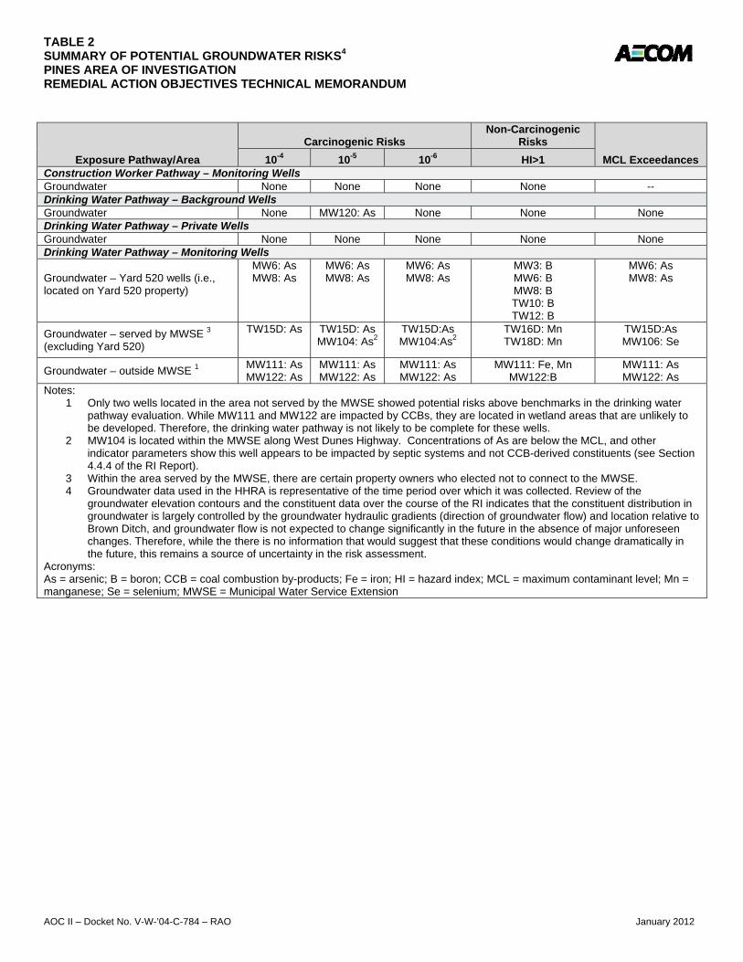
TABLE 2 SUMMARY OF POTENTIAL GROUNDWATER RISKS4 PINES AREA OF INVESTIGATION REMEDIAL ACTION OBJECTIVES TECHNICAL MEMORANDUM
AOC II – Docket No. V-W-’04-C-784 – RAO January 2012
Exposure Pathway/Area
Carcinogenic Risks Non-Carcinogenic
Risks
MCL Exceedances 10-4 10-5 10-6 HI>1 Construction Worker Pathway – Monitoring Wells Groundwater None None None None -- Drinking Water Pathway – Background Wells Groundwater None MW120: As None None None Drinking Water Pathway – Private Wells Groundwater None None None None None Drinking Water Pathway – Monitoring Wells Groundwater – Yard 520 wells (i.e., located on Yard 520 property)
MW6: As MW8: As
MW6: As MW8: As
MW6: As MW8: As
MW3: B MW6: B MW8: B TW10: B TW12: B
MW6: As MW8: As
Groundwater – served by MWSE 3 (excluding Yard 520)
TW15D: As TW15D: As MW104: As2
TW15D:As MW104:As2
TW16D: Mn TW18D: Mn
TW15D:As MW106: Se
Groundwater – outside MWSE 1 MW111: As MW122: As
MW111: As MW122: As
MW111: As MW122: As
MW111: Fe, Mn MW122:B
MW111: As MW122: As
Notes: 1 Only two wells located in the area not served by the MWSE showed potential risks above benchmarks in the drinking water
pathway evaluation. While MW111 and MW122 are impacted by CCBs, they are located in wetland areas that are unlikely to be developed. Therefore, the drinking water pathway is not likely to be complete for these wells.
2 MW104 is located within the MWSE along West Dunes Highway. Concentrations of As are below the MCL, and other indicator parameters show this well appears to be impacted by septic systems and not CCB-derived constituents (see Section 4.4.4 of the RI Report).
3 Within the area served by the MWSE, there are certain property owners who elected not to connect to the MWSE. 4 Groundwater data used in the HHRA is representative of the time period over which it was collected. Review of the
groundwater elevation contours and the constituent data over the course of the RI indicates that the constituent distribution in groundwater is largely controlled by the groundwater hydraulic gradients (direction of groundwater flow) and location relative to Brown Ditch, and groundwater flow is not expected to change significantly in the future in the absence of major unforeseen changes. Therefore, while the there is no information that would suggest that these conditions would change dramatically in the future, this remains a source of uncertainty in the risk assessment.
Acronyms: As = arsenic; B = boron; CCB = coal combustion by-products; Fe = iron; HI = hazard index; MCL = maximum contaminant level; Mn = manganese; Se = selenium; MWSE = Municipal Water Service Extension

TABLE 3
SUMMARY OF STEP 3A OF THE ERA
PINES AREA OF INVESTIGATION
REMEDIAL ACTION OBJECTIVES TECHNICAL MEMORANDUM
COPECs
Sediment
(a)
Groundwater
(b)
Surface Water-
Dissolved
Surface Water-Total
Recoverable
Belted
Kingfisher Mink Raccoon Green Heron
Little Brown
Bat Mallard Muskrat
Sediment
(e)
Groundwater
(f)
ALUMINUM 0.1 0.1 NC NC 0.3 NC NC 0.1 NC 3.0 Not a COPEC
ARSENIC 0.4 Not a COPEC NC NC NC NC NC NC NC NC 0.8
BARIUM 0.2 Not a COPEC NC NC NC NC NC NC NC NC 0.3
BORON NC Not a COPEC 0.0 NC NC NC NC NC NC NC 156
see Table 5-18
for sample by
sample
execcedances
CHROMIUM NC Not a COPEC NC Not a COPEC Not a COPEC Not a COPEC Not a COPEC Not a COPEC Not a COPEC Not a COPEC 14.4
CHROMIUM (HEXAVALENT) Not a COPEC Not a COPEC NC Not a COPEC Not a COPEC Not a COPEC Not a COPEC Not a COPEC Not a COPEC Not a COPEC Not a COPEC
COBALT Not a COPEC Not a COPEC NC Not a COPEC Not a COPEC Not a COPEC Not a COPEC Not a COPEC Not a COPEC Not a COPEC Not a COPEC
COPPER 0.1 NC NC 0.4 NC NC 0.4 NC NC NC 0.2
IRON 0.8
see Table 5-15 for
sample by sample
execcedances NC 3.0 NC NC NC NC NC NC NC 1.6
see Table 5-18
for sample by
sample
execcedances
LEAD 0.1 Not a COPEC 0.0 NC NC NC NC NC NC NC 0.2
MANGANESE 0.3 NC NC NC NC NC NC NC NC NC 1.4
MERCURY Not a COPEC Not a COPEC Not a COPEC Not a COPEC Not a COPEC Not a COPEC Not a COPEC Not a COPEC Not a COPEC Not a COPEC Not a COPEC
MOLYBDENUM NC Not a COPEC NC NC NC NC NC NC NC 0.1 5.6
NICKEL 0.2 Not a COPEC NC NC NC NC NC NC NC NC 0.3
SELENIUM 0.7 NC NC 1.0 NC NC 1.0 NC NC 0.8 6.9
STRONTIUM NC Not a COPEC NC NC NC NC NC NC Not a COPEC NC 0.8
THALLIUM Not a COPEC Not a COPEC NC Not a COPEC Not a COPEC Not a COPEC Not a COPEC Not a COPEC Not a COPEC Not a COPEC Not a COPEC
URANIUM-TOTAL NC Not a COPEC NC Not a COPEC Not a COPEC Not a COPEC Not a COPEC Not a COPEC Not a COPEC Not a COPEC 0.1
VANADIUM NC Not a COPEC NC NC NC NC NC NC NC NC 14.7
ZINC 0.1 Not a COPEC NC NC NC NC NC NC NC NC 0.6
Notes:
CCB - Coal Combustion By-Product.
COPEC - Constituent of Potential Ecological Concern.
EPC - Exposure Point Concentration.
HQ - Hazard Quotient. HQs greater than 1 are presented.
LOAEL - Lowest Observed Adverse Effect Level.
NV - No Value. Ecological screening could not be conducted due to a lack of screeing value.
SERA - Screening Level Ecological Risk Assessment
TRV - Toxicity Reference Value.
(a) Sediment HQs for benthic receptors - average HQ with refined ESV is presented.
(b) Sample by sample groundwater evaluation for benthic community receptors presented in Table 5-15 of the SERA Report.
(c) Surface water HQs - average HQ with refined ESV is presented.
(d) Food web HQs - LOAEL-based HQ for the average EPC is presented.
(e) Sediment HQs for root zone exposure - average HQ presented.
(f) Sample by sample groundwater evaluation for root zone exposure presented in Table 5-18 of the SERA Report.
(g) Suspected CCB HQs for terrestrial plant and invertebrate community receptors - average HQs presented.
Brown Ditch Exposure Area
Benthic Community Aquatic Community (c) Brown Ditch Aquatic Food Web (d) Root Zone Exposure
AOC II – Docket No. V-W-’04-C-784 – RAO January 2012
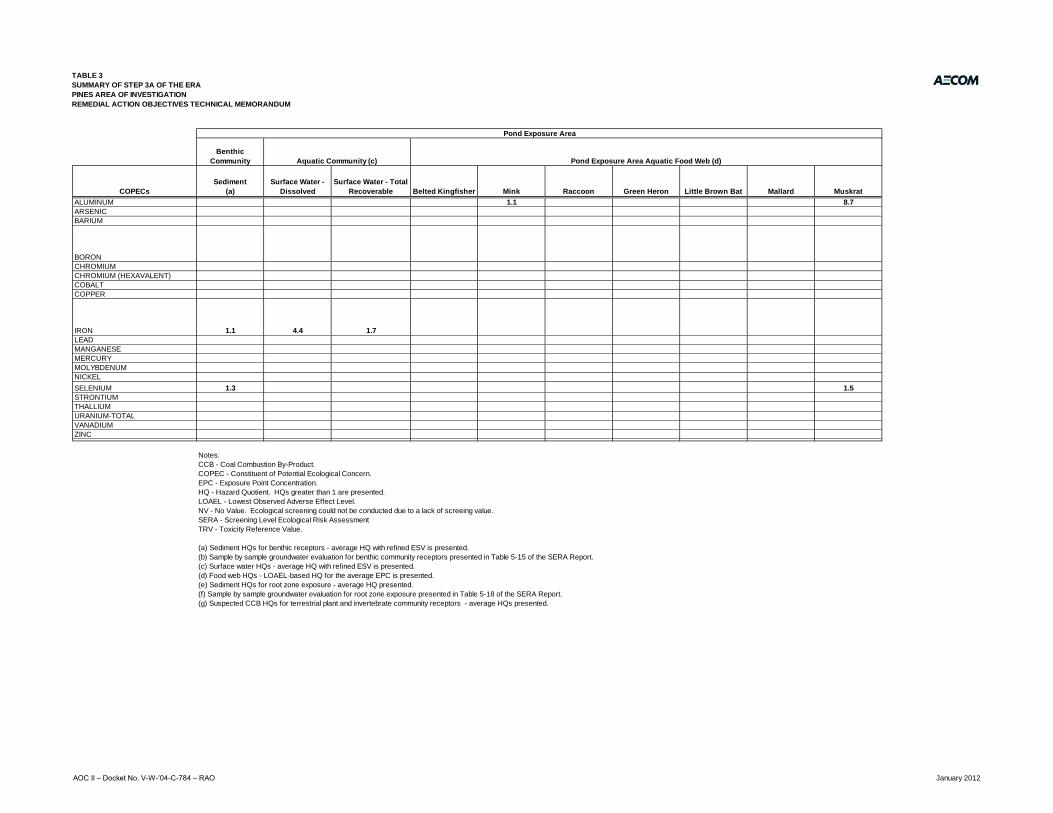
TABLE 3
SUMMARY OF STEP 3A OF THE ERA
PINES AREA OF INVESTIGATION
REMEDIAL ACTION OBJECTIVES TECHNICAL MEMORANDUM
COPECs
ALUMINUM
ARSENIC
BARIUM
BORON
CHROMIUM
CHROMIUM (HEXAVALENT)
COBALT
COPPER
IRON
LEAD
MANGANESE
MERCURY
MOLYBDENUM
NICKEL
SELENIUM
STRONTIUM
THALLIUM
URANIUM-TOTAL
VANADIUM
ZINC
Benthic
Community
Sediment
(a)
Surface Water -
Dissolved
Surface Water - Total
Recoverable Belted Kingfisher Mink Raccoon Green Heron Little Brown Bat Mallard Muskrat
NC 0.1 0.2 NC 1.1 0.1 NC 0.1 NC 8.7
0.6 Not a COPEC NC NC NC NC NC NC NC NC
0.2 Not a COPEC NC Not a COPEC NC NC NC NC NC NC
NC Not a COPEC 0.0 Not a COPEC NC NC NC NC NC NC
NC Not a COPEC Not a COPEC Not a COPEC NC NC NC NC NC NC
Not a COPEC Not a COPEC Not a COPEC Not a COPEC Not a COPEC Not a COPEC Not a COPEC Not a COPEC Not a COPEC Not a COPEC
Not a COPEC Not a COPEC Not a COPEC Not a COPEC Not a COPEC Not a COPEC Not a COPEC Not a COPEC Not a COPEC Not a COPEC
0.4 Not a COPEC NC 0.5 NC NC 0.6 NC NC NC
1.1 4.4 1.7 NC NC NC NC NC NC NC
0.1 Not a COPEC NC Not a COPEC NC NC NC NC NC NC
0.4 0.1 0.1 NC NC NC NC NC NC NC
Not a COPEC Not a COPEC Not a COPEC Not a COPEC Not a COPEC Not a COPEC Not a COPEC Not a COPEC Not a COPEC Not a COPEC
Not a COPEC Not a COPEC Not a COPEC Not a COPEC Not a COPEC Not a COPEC Not a COPEC Not a COPEC Not a COPEC Not a COPEC
0.3 Not a COPEC NC NC NC NC NC NC NC NC
1.3 Not a COPEC NC 0.6 NC NC 0.7 NC NC 1.5
NC Not a COPEC NC NC NC NC NC NC NC NC
Not a COPEC Not a COPEC Not a COPEC Not a COPEC NC NC NC NC NC NC
Not a COPEC Not a COPEC Not a COPEC Not a COPEC Not a COPEC Not a COPEC Not a COPEC Not a COPEC Not a COPEC Not a COPEC
NC Not a COPEC NC NC NC NC NC NC NC NC
0.1 Not a COPEC NC NC NC NC NC NC NC NC
Notes:
CCB - Coal Combustion By-Product.
COPEC - Constituent of Potential Ecological Concern.
EPC - Exposure Point Concentration.
HQ - Hazard Quotient. HQs greater than 1 are presented.
LOAEL - Lowest Observed Adverse Effect Level.
NV - No Value. Ecological screening could not be conducted due to a lack of screeing value.
SERA - Screening Level Ecological Risk Assessment
TRV - Toxicity Reference Value.
(a) Sediment HQs for benthic receptors - average HQ with refined ESV is presented.
(b) Sample by sample groundwater evaluation for benthic community receptors presented in Table 5-15 of the SERA Report.
(c) Surface water HQs - average HQ with refined ESV is presented.
(d) Food web HQs - LOAEL-based HQ for the average EPC is presented.
(e) Sediment HQs for root zone exposure - average HQ presented.
(f) Sample by sample groundwater evaluation for root zone exposure presented in Table 5-18 of the SERA Report.
(g) Suspected CCB HQs for terrestrial plant and invertebrate community receptors - average HQs presented.
Pond Exposure Area
Aquatic Community (c) Pond Exposure Area Aquatic Food Web (d)
AOC II – Docket No. V-W-’04-C-784 – RAO January 2012

TABLE 3
SUMMARY OF STEP 3A OF THE ERA
PINES AREA OF INVESTIGATION
REMEDIAL ACTION OBJECTIVES TECHNICAL MEMORANDUM
COPECs
ALUMINUM
ARSENIC
BARIUM
BORON
CHROMIUM
CHROMIUM (HEXAVALENT)
COBALT
COPPER
IRON
LEAD
MANGANESE
MERCURY
MOLYBDENUM
NICKEL
SELENIUM
STRONTIUM
THALLIUM
URANIUM-TOTAL
VANADIUM
ZINC
Terrestrial Plant
Community (g)
Terrestrial
Invertebrate
Community (g)
Suspected CCBs Suspected CCBs
Red-Tailed
Hawk Red Fox Raccoon
Eastern
Meadowlark
American
Robin Least Shrew Canada Goose Meadow Vole
Eastern
Meadowlark
American
Robin Canada Goose
Not a COPEC Not a COPEC Not a COPEC Not a COPEC Not a COPEC Not a COPEC Not a COPEC Not a COPEC Not a COPEC Not a COPEC Not a COPEC Not a COPEC Not a COPEC
1.3 0.4 NC NC NC NC NC NC NC NC NC NC NC
0.4 0.6 NC NC NC NC NC NC NC NC NC NC NC
166 4.2 NC NC NC NC NC NC NC 0.5 NC NC NC
85.2 213 NC NC NC NC 0.2 0.4 NC NC NC 0.2 NC
0.9 2.3 NC NC NC NC NC NC NC NC NC NC NC
0.9 0.0 Not a COPEC Not a COPEC Not a COPEC Not a COPEC Not a COPEC Not a COPEC Not a COPEC Not a COPEC NC NC NC
NC NC NC 0.0 NC NC 0.1 0.1 NC NC NC NC NC
NC 364 NC NC NC 0.3 0.4 NC NC NC 0.4 0.5 NC
NC NC NC 0.0 0.0 0.0 0.0 0.0 0.0 0.0 NC NC NC
NC NC 0.0 0.0 NC NC NC NC NC NC NC NC NC
NC NC NC NC NC NC 0.0 NC NC NC NC NC NC
2.2 0.0 NC NC NC NC NC 0.3 NC NC NC NC NC
0.9 0.1 NC NC NC NC NC 1.5 NC NC NC NC NC
1.8 0.2 NC NC NC NC NC 0.8 NC NC NC NC NC
Not a COPEC Not a COPEC Not a COPEC Not a COPEC Not a COPEC Not a COPEC Not a COPEC Not a COPEC Not a COPEC Not a COPEC Not a COPEC Not a COPEC Not a COPEC
1.4 NC NC NC NC NC NC 3.5 NC NC NC NC NC
NC NC Not a COPEC Not a COPEC Not a COPEC Not a COPEC Not a COPEC Not a COPEC Not a COPEC Not a COPEC Not a COPEC Not a COPEC Not a COPEC
30.4 3.0 NC NC NC 1.4 2.0 NC NC NC 1.8 2.3 NC
NC NC 0.0 0.0 NC NC 0.8 0.8 NC NC NC NC NC0 0 0
Notes:
CCB - Coal Combustion By-Product.
COPEC - Constituent of Potential Ecological Concern.
EPC - Exposure Point Concentration.
HQ - Hazard Quotient. HQs greater than 1 are presented.
LOAEL - Lowest Observed Adverse Effect Level.
NV - No Value. Ecological screening could not be conducted due to a lack of screeing value.
SERA - Screening Level Ecological Risk Assessment
TRV - Toxicity Reference Value.
(a) Sediment HQs for benthic receptors - average HQ with refined ESV is presented.
(b) Sample by sample groundwater evaluation for benthic community receptors presented in Table 5-15 of the SERA Report.
(c) Surface water HQs - average HQ with refined ESV is presented.
(d) Food web HQs - LOAEL-based HQ for the average EPC is presented.
(e) Sediment HQs for root zone exposure - average HQ presented.
(f) Sample by sample groundwater evaluation for root zone exposure presented in Table 5-18 of the SERA Report.
(g) Suspected CCB HQs for terrestrial plant and invertebrate community receptors - average HQs presented.
Grit Ingestion Evaluation (d)
Terrestrial Exposure Area
Terrestrial Food Web (d)
AOC II – Docket No. V-W-’04-C-784 – RAO January 2012

TABLE 4 SUMMARY OF CHEMICAL-SPECIFIC ARARs PINES AREA OF INVESTIGATION REMEDIAL ACTION OBJECTIVES TECHNICAL MEMORANDUM
AOC II – Docket No. V-W-’04-C-784 – RAO January 2012
Media Requirement Requirement Synopsis Action to be Taken to Attain Requirement Status
Surface Water
Surface Water Quality Standards
327 IAC 2-1.5
The State of Indiana has promulgated Surface Water Quality Standards (SWQS) for surface waters within the Great Lakes System (327 IAC 2-1.5) and waters not within the Great Lakes System (327 IAC 2-1). Surface waters within the Pines Area of Investigation are within the Great Lakes System, thus 327 IAC 2-1.5 apply.
The State regulations state that the chemical, physical, and biological integrity of the waters within the Great Lakes system shall be maintained or restored; thus, the discharge of toxic substances in toxic certain amounts is prohibited, and persistent and bioaccumulating toxic substances shall be reduced or eliminated (these are further discussed below). Further, for all surface waters of the Great Lakes system, existing instream water uses and the level of water quality necessary to protect existing uses shall be maintained and protected. Because the State of Indiana has promulgated surface water standards, they replace the federal WQC as ARARs for surface water in the Pines Area of Investigation.
Applicable
Groundwater Groundwater Quality Standards
327 IAC 2-11
These regulations provide groundwater protection to wells and allow for the classification of groundwater. The rule states that all groundwater of the state shall be classified as “drinking water class” groundwater unless it is classified as “limited class” groundwater or “impaired drinking water class” groundwater. The regulations also provide qualitative and quantitative groundwater quality standards for compounds of concern.
Groundwater in the Pines Area of Investigation has not been classified as “limited class” or “impaired drinking water class”; so is considered a drinking water class groundwater. Thus, for the Pines Area of Investigation, the Indiana GQS are applicable to water wells in the Area of Investigation.
Applicable
Groundwater Safe Drinking Water Act (SDWA)
Maximum Contaminant Levels (MCLs)
40 CFR Part 141 Subpart B (141.11 – 141.13)
MCLs are enforceable standards that regulate the concentration of specific organic and inorganic contaminants that have been determined to adversely affect human health in public drinking water supplies. They may be considered relevant and appropriate for groundwater aquifers potentially used for drinking water.
MCLs are only applicable where groundwater undergoing a CERCLA cleanup is delivered through a public water supply system, if that system has at least 15 service connections or serves at least 25 year-round residents. Groundwater in the Area of Investigation is tapped by some households for potable use (other households have access to a municipal water supply). However, groundwater is typically tapped for potable use on an individual basis, and, no well serves more than 25 year-round residents. Thus the federal MCLs are not applicable.
MCLs are potentially relevant and appropriate for groundwater this is a current or potential source of drinking water (USEPA, August 1991, PB 9234.2-15/FS). Groundwater in the Pines Area of Investigation is considered by the State of Indiana a drinking water class groundwater; thus, the federal MCLs are relevant and appropriate.
The only COPCs in groundwater in the Pines Area of Investigation where concentrations exceed MCLs are arsenic and selenium.
Relevant and Appropriate
Groundwater Health and Environmental Protection Standards for Uranium and Thorium Mill Tailings
40 CFR §192.12
This statute was established to protect human health and the environment from mining and milling activities associated with the nation’s nuclear program at 24 sites that were identified by name in the statute.
While these regulations are only applicable to the control of residual radioactive material at designated processing or depository sites under Section 108 of UMTRCA, USEPA has suggested (and provided guidance) where these criteria should be considered relevant and appropriate at other CERCLA sites. These regulations identify soil levels for radium-226 and thorium by-product material pursuant to Section 84 of Atomic Energy Act (5 pCi/g on the surface [upper 15 cm]).
http://www.epa.gov/superfund/health/contaminants/radiation/pdfs/umtrcagu.pdf
Relevant and Appropriate

AECOM Environment
AOC II – Docket No. V-W-’04-C-784 – RAO January 2012
Figures

BROWN DITCHBROWN DITCH
BROW
N DI
TCH
INDIANA DUNES NATIONAL LAKESHORE (IDNL)
KINTZ
ELE D
ITCH
ARDE
NDAL
E ROA
D
US HIGHWAY 20
YARD 520
WEST DUNES HIGHWAY
MAPL
E STR
EET
PINESLANDFILL
BEVERLY DR
EARL RD
US HIGHWAY 12
COUN
TY LI
NE RD
N 500
E
COUN
TY HI
GHWA
Y 600
E
LAKE
SHOR
E COU
NTY R
OAD
CENTRAL AVE
COUNTY HIGHWAY 1600 N
US HI
GHWA
Y 12
LegendYard 520
Area of Investigation
Surface Water Flow Direction
Roads
Railroads
Wetland Area
Surface Water
Topographic Contours (2-Ft Interval)
Buildings
Figure 1Area of Investigation DetailsPines Area of Investigation
PORTER COUNTY, INDIANA ±Source:Flown on March 13, 2004Basemap prepared by Air Maps Inc.
0 500 1,000 1,500250Feet
AOC II Docket No. V-W-’04-C-784 – RAO January 2012

Yard 520 Type II (North) Area
Yard 520 Type III(South) Area
Lake Michigan
Pines Landfill
Approximate Location of Lawrence Dump
0 1,500750Feet
Figure 2USGS Topographic Map
Pines Area of InvestigationPORTER COUNTY, INDIANALegend
Area of Investigation
Yard 520
Main Branch Brown Ditch (Combined)
West BranchBrown Ditch
Kintzele Ditch
East BranchBrown Ditch
Source: USGSTopographic Quadrangle, 1981Michigan City West, Indiana
±
US Highway 20
Southern Tributaryof Brown Ditch
West DunesHighway
No. V-W-’04-C-784 – HHRA
January 2012
ShattuckP
Text Box
AOCII - Docket No. V-W-'04-C-784-RAO

Yard520
BrownDitch
US Highway 20
Old Chicago Road
Ardendale Road
E 1675 N (Old Chicago Road)
Source:Flown on March 13, 2004Basemap prepared by Air Maps Inc.
0 800 1,600 2,400400Feet
Figure 3Areas Addressed Under AOCs
Pines Area of InvestigationPORTER COUNTY, INDIANA
Legend
Area of Investigation
Water service provided under AOC IWater service provided under AOC I, AmendedLine shown indicates roads where bottled water offeredunder AOC I, Amended.
±January 2012
ShattuckP
Text Box
AOCII - Docket No. V-W-'04-C-784-RAO

BROWN DITCH
BROWN DITCH
BROW
N DI
TCH
INDIANA DUNES NATIONAL LAKESHORE (IDNL)
KINTZ
ELE D
ITCH
ARDE
NDAL
E ROA
D
US HIGHWAY 20
WEST DUNES HIGHWAY
RAILROAD AVE
E 1675 N
OLD CHICAGO ROAD
CARO
LINA
ST
LIBER
TY AV
E
MAINE
AVEPINE ST
BEVERLY DR
EARL RD
US HIGHWAY 12
COUN
TY LI
NE RD
COUN
TY HI
GHWA
Y 500
E
COUN
TY HI
GHWA
Y 600
E
LAKE
SHOR
E COU
NTY R
OAD CE
NTRA
L AVE
COUNTY HIGHWAY 1600 N
US HI
GHWA
Y 12
LegendField Verified Suspected CCB Locations
Inferred suspected CCB Locations
Area of Investigation
Yard 520
Roads
Railroads
Wetland Area
Surface Water
Topographic Contours (2-Ft Interval)
Buildings
Figure 4Results of Suspected CCB
Visual InspectionsPines Area of Investigation
PORTER COUNTY, INDIANA ±Source:Flown on March 13, 2004Basemap prepared by Air Maps Inc.
0 500 1,000 1,500250 FeetNotes:CCBs are present in Yard 520, but not at the ground surface.
Docket No. V-W-’04-C-784 – HHRA January 2012
ShattuckP
Text Box
AOC II - Docket No. V-W-'04-C-784-RAO

~ =
8 ~ -z p
'f f
f (;I ~
I ~
f ;:a.
~ I !" I I ~ -0
m l'J
i
,,. m C>
o I 0 0
i~
i
i
,,. 8
§
§
r z .....,
~ 8 ~ ~
I
i
-i ::: 8
-i -CtJ 0 0 0
I
i1
(.') ~ ill
I I I\) I
0
,...--....
FEET ABOVE MEAN SEA LEVEL z 0
U1 C> C>
0
U1 U1 U1 U1 CJ\ CJ\ CJ\ CJ\ ..., I\) ,,. CJ\ m C> I\) ,,. CJ\ C> C> C> C> C> C> C> C> r+
· ,~d•••••• '•••• ... r l 0 0 0 0 0 0 0 0 0 ::::r rn ~ LAKE MICHIGAN (()
~11n1~·~~ (J)
I I I I I Ng~t~.~<' r+ t I t I t •".. ~~ !~'l. • .11 ~
LAKESHORE/TOLLESTON DUNE-BEACH COMPLEX
MW-3A tv1W-4A (PROJECTED)
~111111111111 ,...--.... (./)
~l!lll!lll!' 53868 0 c r+ ::::r (()
Q (J) r+
'-._./
rn ...-
0 ~ = %
§j a c z
= l""I
z 2
Nl""I~ ~ 9~~ -n UI
~~ c: z ~ (")
l""I 0
~ z
~
CROSS SECTION 8-8'
PINES AREA OF INVESTIGATION ENSR IAECOM
PORTER COUNlY, INDIANA
SQtL£; I !WE: I PROJs:J NUMIEI:
- I DEC 08 I 10785004
ENSR CORPORATION WESTRIRD, llMSSACHUSEJ1S 01886 PHONE; (978) 589-3000 FAX: (178) 589-3100 WEB: HTTP:/ /WWW.ENSR.AECOM.COM
I l l J..sf.t. r •. i;. rrl 11!'\• G')
rrl en ~Z en UI en a ! -1 zs;; oc z,,, =I"( 1::;o c::u l""I ::!l
Rom O OQ c o o> oc z m' s;;a ~ UI~ "< z zc
iil I C') C') ~ ~ :;o :;o !;;J
0 ril 0 -1_ 5 :;o c: z %le
G) c l""I> (5 ~ I G)-<
~ ~ ~ ~5 c: !:a
~~ z '> ~ ~ § i UI~
C-~ :;oz
c ~ (') N :JU E 0 l""I ITI C 0 g .....,. ITI O> - 0 z
(') :;o 0 UI en UI
~ 0 z
5 ~ 0 z en
.._,.EDlll': Rf.'t'llllONS
EP NO.: DESCllPllON: iMm Bt; ....... : KM
CHEQCB> Bt:
MD N'PllMD BY:
EP
ShattuckP
Text Box
5
ShattuckP
Text Box
January 2012
ShattuckP
Text Box
AOC II - Docket No. V-W-'04-C-784-RAO
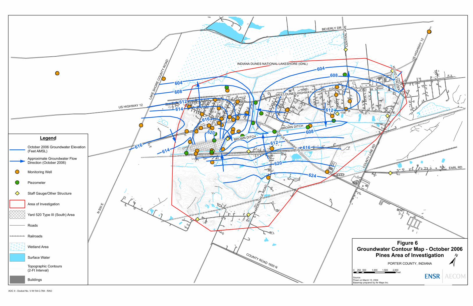
BROWN DITCH
BROWN DITCH
INDIANA DUNES NATIONAL LAKESHORE (IDNL)
KIN
TZEL
E D
ITC
H
ARD
END
ALE
RO
AD
US HIGHWAY 20
WEST DUNES HIGHWAY608
604
608
BEVERLY DR
EARL RD
US HIGHWAY 12
COUN
TY L
INE
RD
N 50
0 E
LAKE
SH
ORE
CO
UNTY
RO
AD
CEN
TRAL
AVE
COUNTY ROAD 1600 N
US H
IGHW
AY 1
2
608604
612616
620
624
614
616
612
612
616
620
614
Legend
October 2006 Groundwater Elevation (Feet AMSL)
Approximate Groundwater Flow Direction (October 2006)
Monitoring Well
Piezometer
Staff Gauge/Other Structure
Area of Investigation
Yard 520 Type III (South) Area
Roads
Railroads
Wetland Area
Surface Water
Topographic Contours (2-Ft Interval)
Buildings
Figure 6Groundwater Contour Map - October 2006
Pines Area of InvestigationPORTER COUNTY, INDIANA
Source:Flown on March 13, 2004Basemap prepared by Air Maps Inc.
0 500 1,000 1,500 2,000250Feet
AOC II - Docket No. V-W-'04-C-784 - RAO
ShattuckP
Text Box
January 2012
ShattuckP
New Stamp

AOC II – Docket No. V-W-’04-C-784 – RAO January 2012
FIGURE 7 CONSERVATIVE MAXIMUM AVERAGE PERCENT CCBs AT GROUND SURFACE - RESIDENTIAL EXPOSURE AREAS REMEDIAL ACTION OBJECTIVES TEHCNICAL MEMORANDUM PINES AREA OF INVESTIGATION

# #
#
#
#
#
##
#
###
##
#
#
#
BROWN DITCH
BROWN DITCH
BROW
N DI
TCH
INDIANA DUNES NATIONAL LAKESHORE (IDNL)
KINTZ
ELE D
ITCH
ARDE
NDAL
E AVE
US HIGHWAY 20
WEST DUNES HIGHWAY
YARD 520
TW-18S
EAST JOHNS AVENUEMAINE
AVE
HICKO
RY AV
E
CARO
LINA
ST
CALIF
ORNI
A ST
BEVERLY DR
EARL RD
US HIGHWAY 12
COUN
TY LI
NE RD
COUN
TY HI
GHWA
Y 500
E
COUN
TY HI
GHWA
Y 600
E
LAKE
SHOR
E COU
NTY R
OAD
CENT
RAL A
VE
US HI
GHWA
Y 12
MW-8
MW-3
MW-6
MW121
MW110
MW113
MW114
MW122
MW105
MW115
MW104
TW-12
MW103
TW-10
MW102
MW124
MW116
MW120
MW119
MW123
TW-16DTW-16S
TW-18D
TW-15DTW-15S
IDEM>8
TP0165
GP0176
GP0166
MW1095MW111
5
MW1176
TP033>5
TP027>7 TP020
>6MW101<1
MW1081.5
MW1061.5
TP026>4.5 MW107
2
TP015>5.5
IDEM 11-12
Legend
#Location of suspected CCB thicknessgreater than 4 feet and at all wellswhere encountered; thickness in feet
Boron Concentrations in GroundwaterAll results <=0.73 mg/l
At least one result >0.73 AND <=7.3 mg/l
At least one result >7.3 mg/l
Field Verified Suspected CCB Locations (see Figure 3-19)Inferred Suspected CCB Locations (see Figure 3-19)Approximate areas of suspected CCBsextending substantially beyond roadways
Area of Investigation
Yard 520
Roads
Railroads
Wetland Area
Surface Water
Topographic Contours (2-Ft Interval)
Buildings
Figure 8Migration of CCB-Derived
Constituents to GroundwaterPines Area of Investigation
PORTER COUNTY, INDIANA ±Source:Flown on March 13, 2004Basemap prepared by Air Maps Inc.
0 500 1,000 1,500250 Feet
AOC II - Docket No. V-W-'04-C-784 - RAO
5
ShattuckP
Text Box
January 2012
ShattuckP
New Stamp

BROWN DITCH
INDIANA DUNES NATIONAL LAKESHORE (IDNL)
KINTZ
ELE D
ITCH
ARDE
NDAL
E AVE
US HIGHWAY 20
WEST DUNES HIGHWAY
0.73
0.73
7.3
7.3
0.73
0.73
0.732.0
2.0
BEVERLY DR
EARL RD
US HIGHWAY 12
COUN
TY LI
NE RD
COUN
TY HI
GHWA
Y 500
E
LAKE
SHOR
E COU
NTY R
OAD
CENT
RAL A
VE
COUNTY HIGHWAY 1600 N
US HI
GHWA
Y 12
LegendBoron Isoconcentration Lines at 0.73,2.0 and 7.3 mg/l
Municipal Water Service Area
Area of Investigation
Roads
Railroads
Wetland Area
Surface Water
Topographic Contours (2-Ft Interval)
Buildings
Figure 9 Estimated Boron in
Groundwater above Comparison LevelsPines Area of Investigation
PORTER COUNTY, INDIANA ±Source:Flown on March 13, 2004Basemap prepared by Air Maps Inc.
0 500 1,000250Feet
AOC II - Docket No. V-W-'04-C-784 - RAO
Notes:Boron isoconcentration lines estimated from all available RI information including: Boron concentrations in groundwater (Figure 4-1) and surface water (Figure 4-22), groundwater hydraulic gradients (Figures 3-5 to 3-9), the presence of larger areas of suspected CCBs (Figure 3-19), and information compiled on Figure 4-18.Isoconcentration lines chosen are human health risk-basedcomparison level (0.730 mg/l) and tap water RSL (7.3 mg/l).
ShattuckP
Text Box
January 2012
ShattuckP
New Stamp

BROWN DITCH
BROWN DITCH
BRO
WN
DIT
CH
INDIANA DUNES NATIONAL LAKESHORE (IDNL)
KIN
TZEL
E D
ITC
H
ARD
END
ALE
AVE
US HIGHWAY 20
WEST DUNES HIGHWAY
MAP
LE S
TREE
T
EAST JOHNS AVE
YARD 520
MW106
BEVERLY DR
EARL RD
US HIGHWAY 12
COUN
TY L
INE
RD
COUN
TY H
IGHW
AY 5
00 E
LAKE
SH
ORE
CO
UNTY
RO
AD
CEN
TRAL
AVE
COUNTY HIGHWAY 1600 N
US H
IGHW
AY 1
2
MW-8ArsenicBoron
MW-6ArsenicBoron
MW-3Boron
TW-12Boron
MW-10Boron
MW124
MW123
MW122ArsenicBoron
MW121
MW120
MW119
MW117MW116
MW115
MW114
MW113
MW111ArsenicIronManganese
MW110
MW109
MW108
MW107
MW105
MW104MW103
MW102
MW101
TW-18S
TW-18DManganese
TW-16S
TW-16DManganese
TW-15S
TW-15DArsenic
Legend
Private Well Sample Location
RI Groundwater Sample Locations
RI Monitoring Well
Yard 520 Monitoring Well
Areas where cumulative risk screening results for the drinking water pathway were above USEPA target risk level of 1E-04 or a target Hazard Index of 1. Risk drivers are identified in the text boxes.
Area of Investigation
Roads
Railroads
Wetland Area
Surface Water
Topographic Contours (2-Ft Interval)
Buildings
Figure 10RI Groundwater and Private Well
Water Sample LocationsDrinking Water Cumulative
Risk Screening ResultsPines Area of Investigation
PORTER COUNTY, INDIANA ±Source:Flown on March 13, 2004Basemap prepared by Air Maps Inc.
0 500 1,000 1,500250Feet
ShattuckP
Text Box
January 2012
ShattuckP
Text Box
AOC II - Docket No. V-W-'04-C-784-RAO