Taunton Wild and Scenic River Study -...
42
National Park Service 1 National Park Service U.S. Department of the Interior Taunton Wild and Scenic River Study Draft Report and Environmental Assessment June 2007
Transcript of Taunton Wild and Scenic River Study -...

National Park Service 1
National Park ServiceU.S. Department of the Interior
Taunton Wild and Scenic River StudyDraft Report and Environmental AssessmentJune 2007


Taunton Wild and Scenic River StudyDraft Report and Environmental Assessment2007
Prepared by National Park Service, Northeast Region
In Cooperation with: » Southeast Region Planning and Economic Development District
» Taunton Wild and Scenic River Study Committee
Project Manager: Jamie Fosburgh, Rivers Program Manager, NER-Boston
Poject Team:Bill NapolitanoProject Leader, SRPEDD
Rachel CalabroPrincipal Author, Taunton River Stewardship Plan, SRPEDD/ MA Riverways
Nancy DurfeeOutreach & Volunteers, SRPEDD
Karen Porter & Maisy McDarby-StanovichMapping & Web Page, SRPEDD
Special Thanks:Jim RossChair, Taunton Wild and Scenic River Study Committee
Comments on this Draft Report can be sent to:Jamie Fosburgh
National Park Service
15 State Street
Boston MA 02109
(617) 223-5191
Please visit www.tauntonriver.org for more information and links related to
the Wild and Scenic River Study, Wild and Scenic River Study Committee,
Taunton River Stewardship Plan, and the Taunton River.
Companion Document: Taunton River Stewardship Plan, July 2005
Cover Photo: Rachel Calabro. Broad Cove, Dighton.


2-4 Summary of Findings
5-7 Chapter I.
5 Background and Need
8-14 Chapter II.
8 Eligibility and Classification Findings
(The Affected Environment)
15-19 Chapter III.
15 Suitability Findings
(Management Context)
20-25 Chapter IV.
20 Identification and Comparison of Alternatives
27-35 Maps 28-29 Study Area Map
30-31 Eligibility and Classification Findings
32-33 Alternative B: Full Designation
34-35 Alternative C: Designation to Steep Brook (N. Fall River)
36-88 Appendices39-41 Appendix A: Study Bill
43-53 Appendix B: Lower Taunton Petition Letters
54-88 Appendix C: Study Press
Table of ContentsTaunton Wild and Scenic Rivers Study Draft Report and Environmental Assessment

2 Taunton Wild and Scenic Rivers Study Draft Report and Environmental Assessment
Eligibility All 40 miles of the mainstem of the Taunton River have been found eligible for Wild and Scenic River designation based upon free-flowing condition and the presence of one or more outstandingly remarkable natural or cultural resource value. The eligible reach extends from the headwaters of the Taunton at the confluence of the Town and Matfield Rivers to Mt. Hope Bay at the US 195 Bridge in Fall River. Outstandingly remarkable values include fisheries; history and archaeology; ecology and biodiversity; and scenery and recreation.
Classification The Wild and Scenic Rivers Act provides for three possible classifications of eli-gible river segments: wild; scenic; and recreational. The criteria distinguishing these classifications are based on the degree of human modification of the river and its adjacent shorelines. Based upon the applicable criteria, the best classifications for Taunton River segments are as follows:
Summary of FindingsTaunton Wild and Scenic Rivers Study Draft Reportand Environmental Assessment
SEGMENT CLASSIFICATION LENGTH
Headwaters to Rte 24 in Raynham Scenic 18 mi
Rte 24 to .5 mi below Weir Bridge in Taunton Recreational 5 mi
.5 mi below Weir Bridge to Muddy Cove in Dighton Scenic 8 mi
Muddy Cove to Rte 195 in Fall River Recreational 9 mi
Suitability The principal factors considered in de-termining suitability for designation are discussed in Chapter III of this Report and relate to the river area’s potential to be effectively managed and protected as a component of the national river sys-tem. These include: adequacy of exist-ing and proposed protection measures; adequacy of existing and proposed management framework; the presence or absence of local support; and the ef-fects of designation.
Based on these factors, the entire main-stem of the Taunton is deemed suitable for designation. However, the potential development of the proposed Weaver’s Cove Liquified Natural Gas facility in Fall River, could be in conflict with Wild and Scenic River designation of the low-er-most portion of the Taunton River. The Department of the Interior has ad-dressed this project and its relationship to the potential Wild and Scenic River designation of the Taunton in letters of
“The eligible reach ex-tends from the headwa-ters of the Taunton at the confluence of the Town and Matfield Rivers to Mt. Hope Bay at the US 195 Bridge in Fall River.”

National Park Service 3
September 17, 2004 and July 5, 2005 on FERC’s Draft and Final Environmental Impact Statement (respectively), and in letters dated September 22, 2004 and February 7, 2006 to the U.S. Army Corps of Engineers. Throughout this period, the Weaver’s Cove LNG project has con-tinued to evolve. Most recently (after close of the Corps comment period on Feb 8), the applicant announced plans to dramatically revise their proposal in fa-vor of a new class of smaller LNG tanker ships. Such a project change would, in turn, likely change completely the scope and nature of potential environmental impacts related to DOI’s principal area of concern — dredging impacts to fisher-ies resources.
Because this lower portion of the Taunton was added to the Wild and Scenic River Study area based on community petition and requests from members of congress (rather than included in the original study legislation), this portion is not sub-ject to the legislative interim protection afforded Study Rivers. It is therefore pos-
sible that the Weaver’s Cove LNG facility will be approved based on conditions not compatible with Wild and Scenic River designation of the lower-most portion of the Taunton River.
Therefore, this Draft Report evalu-ates two Wild and Scenic River designation alternatives:
Alternative B: Designation of the En-tire Mainstem is identified as the Envi-ronmentally Preferred Alternative.
Alternative C: Designation of Main-stem of the Taunton River from Headwa-ters to Steep Brook in North Fall River is identified as an appropriate designation alternative pending potential approval of the Weaver’s Cove LNG facility with site impacts not compatible with Wild and Scenic River designation.
Taunton River Stewardship PlanThe Taunton River Stewardship Plan is the most important product of the Wild
Photo: Rachel Calabro. Assonet River, Assonet Village, Freetown.
Photo: Joan Kimball. “Pudding Stone” on the Assonet River.
Summary of Findings

4 Taunton Wild and Scenic Rivers Study Draft Report and Environmental Assessment
and Scenic River Study. It was developed through the efforts of the Study Com-mittee and presents a vision of the values for which the Taunton River is cherished, and of the strategies to better manage and protect these values. It has been exten-sively reviewed by local and state stake-holders represented on the Committee (including communities, state agencies, non-profit, and tribal stakeholders) as a draft, and was formally endorsed by all ten communities as noted below. It should be read as a companion docu-ment to the Study Report. The Study Re-port adds to the Stewardship Plan only in the specific areas of Wild and Scenic River Eligibility, Suitability, and Alterna-tives/Environmental Assessment — in all other areas, the more complete source is the Stewardship Plan.
Support for Designation Between November of 2004 and July of 2005, the legislative bodies of all ten communities abutting the mainstem of
the Taunton River have voted (all but one unanimously) to support the Taunton River Stewardship Plan and Wild and Scenic designation (Stewardship Plan, Appendix D). The Taunton Wild and Scenic River Study Advisory Commit-tee, representing the communities, state agency and non-governmental partners, has also voted unanimously to recom-mend federal designation. Little or no opposition to designation has been voiced as a part of the study or commu-nity consideration process.
www.Tauntonriver.orgA special effort was made through this Wild and Scenic River Study to de-velop and maintain a website as an in-tegral aspect of the Study. A great deal of background information, research and study-related materials have been made available through the site, and it has functioned throughout the Study as an important component of public out-reach and communication.
Photo: Rachel Calabro. The Lower Taunton offers a wide variety of boating opportunities.
“Between November of 2004 and July of 2005, the legislative bodies of all ten communities abutting the mainstem of the Taunton River have voted (all but one unani-mously) to support the Taunton River Steward-ship Plan and Wild and Scenic designation.”
Summary of Findings

National Park Service 5
This chapter provides an Introduction to the Wild and Scenic Riv-ers Act and the Taunton River Study. It includes a review of the project’s history, the study strategy and process, the principal par-ticipants, and the major study products and accomplishments.
To date, approximately 176 river seg-ments have been added to the national system, totaling approximately 11,338 river miles. Of the designated segments, only six are located in New England: the Farmington in Connecticut; the Al-lagash in Maine; the Wildcat and Lam-prey in New Hampshire; and the West-field and Concord-Sudbury-Assabet in Massachusetts. One additional study is ongoing in New England — the Eight-mile River in Connecticut.
Each river designated into the national system receives permanent protec-tion from federally licensed or assisted dams, diversions, channelizations and other water projects that would have a direct and adverse effect on its free-flowing condition and identified “out-standingly remarkable” resource values. The Wild and Scenic Rivers Act explic-itly prohibits any new dam or other project licensed by the Federal Energy Regulatory Commission (FERC) on or directly affecting a designated river seg-ment, and requires that all other pro-posed federally assisted water resource development projects in the area be evaluated for their potential impacts on the river’s “outstandingly remarkable” values and free-flowing condition. Any project that would result in adverse ef-fects to the designated segment is pre-cluded under the Act.
Chapter IBackground and Need
I.ABackground on the Wild & Scenic Rivers ProgramEnacted in 1968, the National Wild and Scenic Rivers Act (P.L. 90-542, as amended) was created to balance long-standing federal policies promoting construction of dams, levees, and other river development projects with one that would permanently preserve se-lected rivers, or river segments, in their free-flowing condition. Section 1(b) of the Act states:
It is hereby declared to be the policy of the United States that certain se-lected rivers of the Nation which, with their immediate environments, possess outstandingly remarkable scenic, recreational, geologic, fish and wildlife, historic, cultural, or other similar values, shall be pre-served in free-flowing condition, and that they and their immediate environments shall be protected for the benefit and enjoyment of present and future generations.
The original Act designated eight rivers into the National Wild and Scenic Riv-ers System, and specified processes by which other rivers could be added to the system.
Chapter I

6 Taunton Wild and Scenic Rivers Study Draft Report and Environmental Assessment
This same protection is provided on a temporary basis for rivers that are under formal, legislatively authorized study for potential addition to the national sys-tem. The interim protection remains in place from the date of study authoriza-tion until Congress makes a decision on whether or not to designate the river into the national system, or until three years after a final study report is transmitted to Congress by the President, whichever comes first.
I.B Taunton River Study Background
History There is a long history of local interest in protecting the natural, cultural and recreational values of the Taunton Riv-er. As early as 1988, the Upper Taunton River Conservation and Management Plan developed by the abutting com-
munities and the Southeast Regional Planning and Economic Development District (SRPEDD) called for consider-ation of the Upper Taunton as a National Wild and Scenic River. Again in 1997, the communities organized to pursue status as an American Heritage River. Both of these efforts are emblematic of the grow-ing community awareness of the Taunton and its special values.
Formal efforts to pursue a wild and scenic river study began as a direct outgrowth of the unsuccessful American Heritage River campaign, and in October 2000, the Upper Taunton Wild and Scenic Riv-er Study Bill became law (Appendix A).
Expansion of the Study Area The Study Act directed the National Park Service to study the Upper Taunton River from its headwaters at the conflu-ence of the Town and Matfield Rivers to the confluence of the Forge River in Raynham. Shortly after enactment of the Study Bill, the National Park Service, with assistance from SRPEDD, formed a locally-based Upper Taunton Wild and Scenic River Study Committee including the communities of Halifax, Bridgewater, Middleborough, Raynham and Taunton. From the outset, representatives from the lower Taunton communities attended the monthly Committee meetings to request inclusion in the effort. By the winter of 2001/2002, the Lower Taunton com-munities of Taunton, Raynham, Berkley, Dighton, Somerset, Freetown and Fall River had formed a working group as-sisted by Pat Rogers, head of the Taunton Basin for the Commonwealth of Mas-sachusetts Watershed Initiative, to seek inclusion in the Wild and Scenic River Study.
As of September, 2002 all of the Lower Taunton communities had written letters
“There is a long his-tory of local inter-est in protecting the natural, cultural and recreational values of the Taunton River. ”
Photo: Rachel Calabro. Forge River at Rte 44, Raynham.
Photo: Rachel Calabro. Kiosk at Johnson Pond Park, Raynham.
Chapter I

National Park Service 7
requesting formal inclusion in the Study, and US Congressional Representatives Frank, McGovern and Lynch wrote to the National Park Service to request formal extension of the Study Area (Ap-pendix B). After touring the Lower River area with NPS regional and Washington DC officials and considering budgetary and timing implications, the NPS ap-proved the extension and the Study Area was expanded.
Partnership Study ApproachThe NPS approach to the Taunton Wild and Scenic River Study is based on an approach developed over the last 20 years in the northeast region through a succession of Wild and Scenic River studies and designations, including Wildcat Brook (NH); Farmington R (CT); Great Egg Harbor R (NJ); Mau-rice R. (NJ); White Clay Creek (DE/PA); Lower Delaware R (NJ/PA); Lamprey R. (NH); Sudbury, Assabet & Concord R (MA). Each of these studies and subse-quent designations have been based on
a “Partnership” model that emphasizes local participation in the study process. The centerpiece of this approach is the locally-based Study Committee, detailed on page II of the Taunton River Steward-ship Plan. Additional salient features of this approach include:
» A high emphasis on public education and participation
» Reliance on local and state protections vs. federal
» No federal acquisition anticipated or authorized
» Development of a locally-based man-agement plan as a part of the study
» Implementation of the Plan through a locally-based committee structure
This approach is more fully discussed in the Introduction and Chapter VII of the Taunton River Stewardship Plan.
Photo: Rachel Calabro. Massachusetts Riverways measuring stream flow, Namasket River.
“The NPS approach to the Taunton Wild and Scenic River Study is based on an approach developed over the last 20 years.”
Chapter I

8 Taunton Wild and Scenic Rivers Study Draft Report and Environmental Assessment
The purpose of this chapter is to document National Park Service findings relative to: 1) the “outstandingly remarkable” natural and cultural resource values associated with the Taunton River study area; 2) the “free-flowing character” of study segment; and 3) pro-posed “classifications” under which eligible river segments could be included in the National Wild and Scenic Rivers System.
II.A. Eligibility & Classification CriteriaThe subsections below describe the relevant eligibility and classification criteria as set forth in the Wild and Scenic Rivers Act and in the USDA/USDI Interagency Guidelines for Eligibility, Classification, and Management of River Areas as published in the Fed-eral Register on September 7, 1982.
Outstandingly Remarkable Values To be considered eligible for inclusion in the National Wild and Scenic Rivers Sys-tem a river segment, together with its adjacent lands, must support one or more “outstandingly remarkable” natural, cultural, or recreational resource values. Such resource values must be directly related to, or dependant upon, the river. The “outstandingly remarkable” threshold within the Act is designed to be interpreted through the professional judgement of the study team.
Chapter IIEligibility and Classification Findings (The Affected Environment)
Photo: Rachel Calabro. Segreganset River, Dighton.
“To be considered eli-gible for inclusion in the National Wild and Scenic Rivers System a river segment, together with its adjacent lands, must support one or more “outstandingly remarkable” natural, cultural, or recreation-al resource values. ”
National Park Service 9
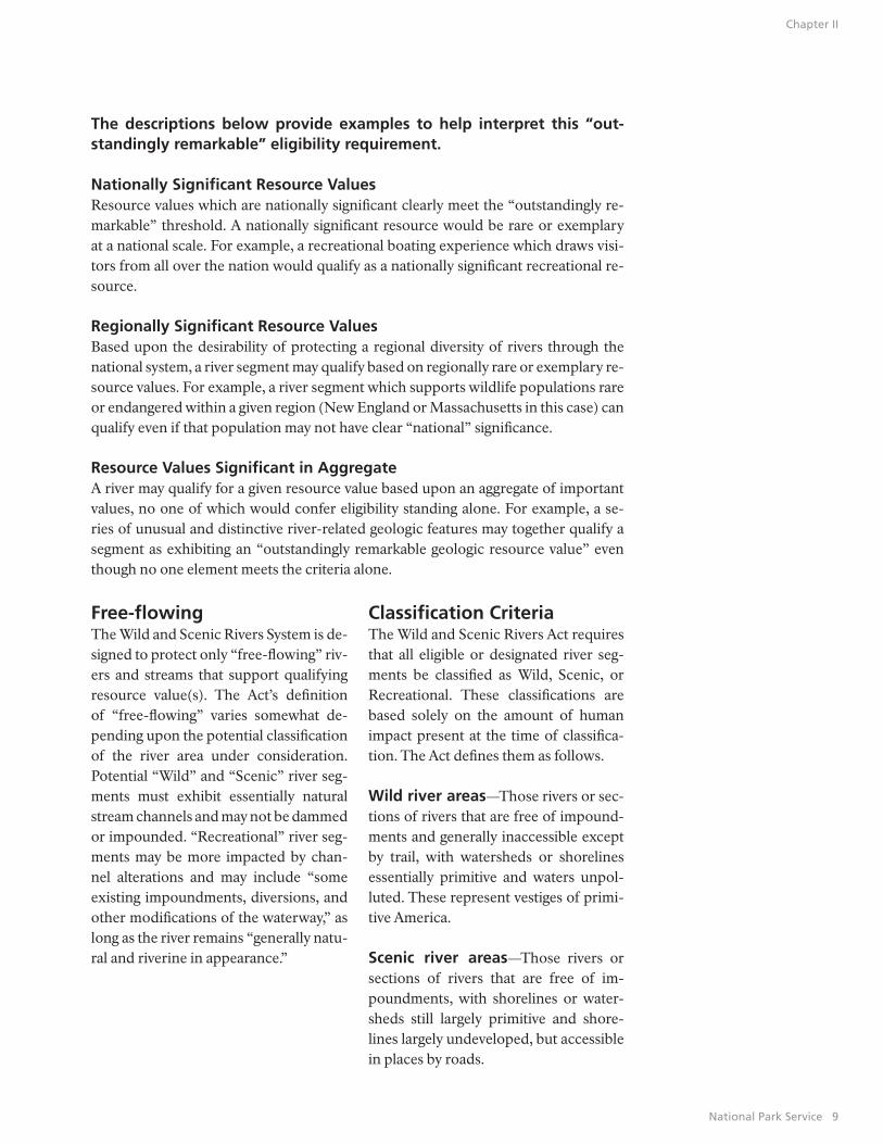
Free-flowing The Wild and Scenic Rivers System is de-signed to protect only “free-flowing” riv-ers and streams that support qualifying resource value(s). The Act’s definition of “free-flowing” varies somewhat de-pending upon the potential classification of the river area under consideration. Potential “Wild” and “Scenic” river seg-ments must exhibit essentially natural stream channels and may not be dammed or impounded. “Recreational” river seg-ments may be more impacted by chan-nel alterations and may include “some existing impoundments, diversions, and other modifications of the waterway,” as long as the river remains “generally natu-ral and riverine in appearance.”
Classification Criteria The Wild and Scenic Rivers Act requires that all eligible or designated river seg-ments be classified as Wild, Scenic, or Recreational. These classifications are based solely on the amount of human impact present at the time of classifica-tion. The Act defines them as follows.
Wild river areas—Those rivers or sec-tions of rivers that are free of impound-ments and generally inaccessible except by trail, with watersheds or shorelines essentially primitive and waters unpol-luted. These represent vestiges of primi-tive America.
Scenic river areas—Those rivers or sections of rivers that are free of im-poundments, with shorelines or water-sheds still largely primitive and shore-lines largely undeveloped, but accessible in places by roads.
The descriptions below provide examples to help interpret this “out-standingly remarkable” eligibility requirement.
Nationally Significant Resource ValuesResource values which are nationally significant clearly meet the “outstandingly re-markable” threshold. A nationally significant resource would be rare or exemplary at a national scale. For example, a recreational boating experience which draws visi-tors from all over the nation would qualify as a nationally significant recreational re-source.
Regionally Significant Resource ValuesBased upon the desirability of protecting a regional diversity of rivers through the national system, a river segment may qualify based on regionally rare or exemplary re-source values. For example, a river segment which supports wildlife populations rare or endangered within a given region (New England or Massachusetts in this case) can qualify even if that population may not have clear “national” significance.
Resource Values Significant in AggregateA river may qualify for a given resource value based upon an aggregate of important values, no one of which would confer eligibility standing alone. For example, a se-ries of unusual and distinctive river-related geologic features may together qualify a segment as exhibiting an “outstandingly remarkable geologic resource value” even though no one element meets the criteria alone.
Chapter II

10 Taunton Wild and Scenic Rivers Study Draft Report and Environmental Assessment
Recreational river areas—Those riv-ers or sections of rivers that are readily accessible by road or railroad, that may have some development along their shorelines, and that may have undergone some impoundment or diversion in the past.
II.B. Relationship to Taunton River Stewardship PlanThe Taunton River Stewardship Plan identifies six categories of outstanding resources associated with the Taunton study area: Agriculture; Ecology and Bio-logical Diversity; Estuary; Fisheries and Aquatic Resources; History and Archeol-ogy; and Scenery and Recreation. These are the resources that were researched and explored by the Study Committee, and recognized and valued by the com-munities and the river stakeholders.
The “Outstandingly Remarkable” values noted below are taken from the Steward-ship Plan and its research, but, in some cases are packaged differently to empha-
size Wild and Scenic River purposes. For example, “hydrology” warrants specific recognition as an “outstandingly remark-able” Wild and Scenic River value based on the specific purpose of the Wild and Scenic Rivers Act to protect free-flow-ing character. Similarly, the communities and Study Committee recognize Agricul-ture within the corridor as a stand-alone value worthy of note, while, for Wild and Scenic purposes, agriculture is more ap-propriately a contributor to the open space, archeology, habitat diversity, sce-nic and cultural values of the corridor. Similarly, the estuary value cited in the Stewardship Plan is recognized in the Fish and Ecology and Biological Diversi-ty “outstandingly remarkable” Wild and Scenic River values.
The Stewardship Plan is the best over-all expression of the values associated with the Taunton River study area. The “outstandingly remarkable” values cited below should be read as a way to charac-terize these values that is most consistent with Wild and Scenic River purposes.
Photo: Historic cemetary, Freetown.
“The Stewardship Plan is the best over-all expression of the values associated with the Taunton River study area.
Chapter II

National Park Service 11
II.C. Outstandingly Remark-able Resource ValuesThis subsection describes the natural and cultural resource values supported by the Taunton River through the study area that are deemed to meet the “Outstandingly Remarkable” threshold. More detailed in-formation on these resource values can be found in the Taunton River Stewardship Plan and on the Study web site, taunton-river.org. All of the resources cited contrib-ute to the overall eligibility of the Taunton River. Not all river reaches in the study area support all noted outstanding val-ues, but there is no stretch of river which does not contribute to the viability of the whole.
Outstandingly Remarkable Value: HydrologyThe entire 40 mile mainstem of the Taunton River is undammed, making the Taunton the longest undammed main-stem coastal river in New England. This
free-flowing character is the foundation for many of the Taunton’s special values, ranging from colonial shipbuilding his-tory to anadromous fish and recreational boating value. Preservation of free-flow-ing condition is one of the principal purposes of the Wild and Scenic River System, making this outstandingly re-markable hydrologic value particularly relevant to wild and scenic river eligibil-ity.
Outstandingly Remarkable Value: FishThe Taunton River is one of Massa-chusetts’ and New England’s most sig-nificant anadromous fish rivers. It sup-ports the state’s largest herring run. The Taunton system supports anadromous and catadromous fish species including, alewife, blueback herring, American eel, American shad, hickory shad, gizzard shad, rainbow smelt, white perch, striped bass, and the endangered Atlantic stur-geon. Significantly, these migratory fish values of the Taunton have the potential
Photo: Assonet River, floodstage. Photo: Rachel Calabro. Paynes Cove, Assonet Bay Shores, Freetown.
“The Taunton River is one of Massachusetts’ and New England’s most significant anad-romous fish rivers.”
Chapter II

12 Taunton Wild and Scenic Rivers Study Draft Report and Environmental Assessment
to be even much greater, given that his-torical habitat of numerous tributaries remain blocked by dams. Fisheries Re-ource Map A on page 46 of the Taunton River Stewardship Plan shows existing and potential anadromous fish habitats. The Taunton River estuary also supports critical spawning and rearing habitat for many species of fish and shellfish, in-cluding winter flounder. The lack of a “head of tide” dam allows these habitats and species to be fully connected, a rare occurance in New England and unique among larger order coastal rivers.
Outstandingly Remarkable Value: Ecology and Biological DiversityThe Taunton River is one of the most intact river ecosystems in New England and supports multiple attributes ranked as global conservation targets. The cor-ridor supports 31 distinct wildlife habi-tats, three globally rare plant species, regionally significant freshwater and brackish tidal marshes, and many rare species of birds and amphibians. Seals are often found to the upper reaches of the Taunton and its tributaries – a phe-nomenon unique to the Taunton among Massachusetts Rivers. The Taunton Riv-er estuary, mainstem and major tributar-ies have been found by the Nature Con-servancy to be one of the most unique, diverse, and intact ecological systems in the North Atlantic Ecoregion, from Dela-
ware to Maine. Fish, plant and animal re-sources, including rare and endangered species, as well as quantity and quality of habitat in general have been found ex-ceptional. The undammed mainstem of the Taunton is the centerpiece of this system.
Outstandingly Remarkable Value: Scenery and RecreationThe Taunton River is an outstanding flatwater boating recreational resource, ideal for family-oriented day or over-night outings. The upper Taunton, from the confluence of the Town and Matfield Rivers to the Rte 24 area offers intimate canoeing and kayaking in a semi-wilder-ness setting that provides outstanding opportunities for birding, wildlife view-ing, and exposure to diverse riparian and floodplain habitat types. Below Taunton, the River slowly transforms into a tidal estuarine habitat, again offering excep-tional small boating opportunities to the Berkely-Dighton Bridge and beyond. The lowermost portion of the river (Free-town, Somerset and Fall River) opens up to expansive views and more diverse boating opportunies, including sailing and power boating. This lowermost por-tion exhibits a more developed character than the other portions, but still supports excellent recreational opportunities and access. The Commonwealth of Massa-chusetts’ Taunton Heritage River Map on page 62/63 of the Taunton River Steward-ship Plan depicts some of the recreation features and access sites on the river (a statewide pilot effort to recognize and celebrate outstanding cultural and recre-ational river areas).
Outstandingly Remarkable Value: History and ArchaeologyThe Taunton River corridor is one of the Commonwealth of Massachusetts’ most studied and recognized archaeological
Photo: Rachel Calabro.. Historic arch bridge, Assonet River,
“The Taunton River is one of the most intact river ecosys-tems in New England...”
Photo: Broad Cove, Dighton.
Chapter II

National Park Service 13
resource areas for Native American ar-chaeology. Sites include the Titicut, Fort Hill, Taylor Farm and Seaver Farm sites. The River itself offered outstanding fish, shellfish and transportation opportuni-ties, while floodplains were ideally suited to agricultural use and tributaries offered excellent opportunities for fish weirs and encampment sites. Many of these same characteristics attracted early colonial settlers who found that the river offered excellent opportunities to ship goods pro-duced along its banks and on tributaries. Shipbuilding was one well known early industry, with remnants of that industry visible in many locations today, such as the Titicut site in Bridgewater. Tributaries supported typical colonial New England mill development, utilizing the Taunton for transportation. Later, Fall River took advantage of its location to surpass Low-ell as the nation’s largest textile produc-ing center. The river also flourished as a Victorian era resort center focused on the lower River. The rich and diverse history and archaeology of the Taunton River is still being uncovered and documented by active local historical societies and com-missions, and a significant aspect of the Taunton River Stewardship Plan includes recognition and celebration of important themes and sites.
II.D. Free-Flowing Determination This subsection describes the free-flowing character of the study segment.
As described in the Hydrology sec-tion above, the entire mainstem of the Taunton River is free-flowing. The only significant modifications to the natural river channel and river banks occurs in the Fall River/Somerset portion of the River. In this area, there are substantial portions of the riverbank that have been hardened with rip-rap and seawalls. There is also an existing federal naviga-tion channel and turning basin that ex-tends up the Taunton River from Mt. Hope Bay approximately 1.5 miles. The existing channel and turning basin are subject to maintenance dredging. Based upon these human channel modifica-tions, this portion of the Taunton River can only be considered to meet the “rec-reational” classification, under which pre-existing channel modifications are acceptable.
Photo: Rachel Calabro. Kayaker, Taunton River.
“The [Taunton] river also flourished as a Victorian era resort center focused on the lower River.”
Photo: Rachel Calabro. Battleship Cover, Fall River.
Chapter II

14 Taunton Wild and Scenic Rivers Study Draft Report and Environmental Assessment
II.E. Proposed Classifications This subsection defines the proposed classifications for portions of the river found eligible for designation.
Segment 1: Confluence of the Town and Matfield Rivers to the Rte 24 Crossing in Raynham: ScenicThis 18 mile segment of the Taunton River is remarkably wild in appearance, with only occasional human intrusions. There are three roadway bridges and some stretches where highway noise from routes 495 and 44 are noticeable. Overall, this section of-fers a feeling of seclusion and removal from human interference. The recommended classification for this segment is Scenic.
Segment 2: Rte 24 Crossing to .5 mi below the Weir Bridge in Taunton: RecreationalMuch of this segment of the River is closely paralleled by Route 44. Presence of paral-lel roads is one of the salient characteristics of a recreational river segment as defined in the Wild and Scenic Rivers Act. The recommended classification for this river segment is Recreational.
Segment 3: .5 mi below Weir Bridge to Muddy Cove, Dighton: ScenicThis segment returns to a wild and remote character, with few human intrusions. Near the bottom of this stretch of River occasional homes become visible, but they are generally setback from the river and not concentrated in a manner that detracts from the natural river setting. The recommended classification for this river segment is Scenic.
Segment 4: Muddy Cove to the Rte 195 Bridge in Fall River: RecreationalThis segment is chacterized by increasing riverfront development, including residen-tial and commercial/industrial uses. The west side of the river (Freetown/Fall River) remains relatively undeveloped as far south as Steep Brook in north Fall River, while the east bank is fairly heavily developed through much of the segment.
South of Steep Brook, much of the west river bank is hardened by seawall/riprap, as are many areas on the east bank. This portion also includes channel modifications in the form of an existing federal navigation channel and turning basin, rendering this area only appropriate for consideration under the “recreational” classification. The recommended classification for this river segment is Recreational.
Photo: Rachel Calabro. Taunton River, Somerset.
Chapter II

National Park Service 15
This chapter states the study’s findings relative to Section 4(a) of the Wild and Scenic Rivers Act that requires the study report to detail the river’s suitability or non-suitability for national designation. The factors examined relate to the management context and the ability to effectively manage and protect the potential Wild and Sce-nic River Segments.
III.A. Principal Factors of SuitabilityFor rivers such as the Taunton that flow through predominantly private lands the National Park Service has identified several factors upon which the suitabil-ity decision should be made:
(1) the adequacy of existing protection measures to conserve the river’s out-standing resources without the need for federal land acquisition or federal land management;
Chapter IIISuitability Findings (The Management Context)
(2) whether there is an existing or pro-posed management framework that will bring the key river interests together to work toward the ongoing protection of the river; and
(3) the strength of local support for riv-er protection and national designation; and
(4) the effects of designation on uses of the land, water base, and resources associated with the river, the neighbor-ing communities, etc. (addressed under Chapter IV: Environmental assessment of Alternatives).
Photo: Taunton Green, Taunton.

16 Taunton Wild and Scenic Rivers Study Draft Report and Environmental Assessment
III.B. Existing Regula-tory Protection
Appendix A of the Taunton River Stew-ardship Plan Local Zoning and State and Federal Programs for Protection of Outstanding Values in the Taunton Wild and Scenic River Corridor contains a full discussion of the various local, state and federal programs that contribute to the protection of the Taunton River and its resources. All of the affected communi-ties have comprehensive local zoning ordinances. The local protection scheme is directly related to several key state statutes that are implemented locally through community Conservation Com-missions, these include:
» Massachusetts Wetlands Protection Act: provides critical protection for floodplains, wetlands and watercours-es by restricting human alteration of these areas and a 100ft buffer zone.
» Rivers Protection Act: establishes a 200ft buffer zone around rivers and perennial streams within which devel-opment is generally prohibited, and, where allowed due to lack of feasible alternatives, must meet strict protec-tion standards.
Statutes directly implemented by the Commonwealth include the Water Man-agement Act and Interbasin Transfer Act which provide critical protection to in-stream flow by regulating withdrawals and interbasin transfers of water.
Overall, the Taunton, as with rivers in Massachusetts in general, are subject to a substantial level of existing resource protections, which, when combined with the added statutory protections of Wild and Scenic River designation from adverse federal actions, is deemed a suf-ficient regulatory protection framework for Wild and Scenic River suitability.
III.C. Management FrameworkChapters II, III and IV of the Taunton River Stewardship Plan detail the pro-posed management framework for implementation of the river protection strategies and the Wild and Scenic des-ignation in particular. The centerpiece of this framework is the creation of an advisory coordinating body: the Taunton River Stewardship Council. The makeup of the Council is detailed in the Steward-
Photo: Rachel Calabro. Agricultural lands like these in Middleborough, offer open vistas and important cultural value.
“Overall, the Taunton, as with rivers in Massa-chusetts in gener-al, are subject to a substantial level of existing resource protections...”
Chapter III

National Park Service 17
ship Plan, and includes identified com-munity, non-governmental, and state agencies. Each of the entities specified for inclusion on the Stewardship Council has endorsed its membership and partic-ipation on the Stewardship Council, and most have supplied letters documenting support for the Plan and Council (Stew-ardship Plan, Appendix D).
The Stewardship Plan itself includes Ob-jectives and Action Strategies that have been developed through a locally-based facilitation process, and each community has formally endorsed the Plan through Town Meeting vote or City Council ac-tion. This sort of management frame-work has proven a successful coordina-tion and implementation approach on the seven other northeast Wild and Sce-nic Rivers that are managed through a similar scheme.
III.D. Additional Sup-porting Programs and InitiativesIn addition to the direct management framework provided by the Taunton
River Stewardship Plan and Stewardship Council, several additional initiatives and programs warrant mentioning as existing and future contributors to coordination and protection initiatives.
The Commonwealth of Mas-sachusetts Heritage Rivers ProgramConcurrent with conduct of the Wild and Scenic River Study, the Taunton Riv-er was chosen as the focus of a new state pilot program: the Taunton Heritage River. Designed to celebrate and recog-nize outstanding natural, cultural and recreation river attributes, the Heritage River Program developed a site marker program for the Taunton (see Steward-ship Plan pgs 62-63), including a unify-ing logo for heritage site identification. This pilot was successful, and its imple-mentation has been incorporated into the Taunton River Stewardship Plan. The Commonwealth’s Riverways Program, which developed the Heritage River pi-lot, is a key state partner for the NPS on the Taunton, as on the existing SuAsCo and Westfield Wild and Scenic Rivers in Massachusetts.
Photo: Rachel Calabro. The Taunton at Weir Village.
Photo: Rachel Calabro. Winnetuxet River, Halifax.
Chapter III

18 Taunton Wild and Scenic Rivers Study Draft Report and Environmental Assessment
Sheehan Family Foundation’s Taunton Watershed Cam-paignIn August 2005, the Sheehan Family Foundation announced a focused grant campaign targeted toward the protection of the Taunton’s outstanding resource values. Specifically citing the success of the Wild and Scenic River study effort and community votes in support of the Stewardship Plan, the Foundation an-nounced an initial $250,000 grant round targeted to environmental organizations in the watershed. The Nature Conservancy Taunton Watershed Focus AreaThe Taunton River watershed lies with-in the North Atlantic Coast ecoregion, which enompasses the coastal areas of nine states from Delaware to Maine. During the conduct of the Wild and Sce-nic Study, The Nature Conservancy com-pleted its ecoregional assessment of the North Atlantic Ecoregion and identified the Taunton and six tributaries as focus areas for its long-term efforts to protect
outstanding examples of biological di-versity. TNC’s assessment found that the Taunton watershed is home to 42 ecore-gional target species. Based on these findings, TNC has launched a protection campaign targeted toward preservation of the special species and habitats of the Taunton mainstem and tributaries, and has joined the Taunton River Steward-ship Committee formed as an outgrowth of the Wild and Scenic River Study.
Save the Bay—Narragansett Bay EstuaryThe Taunton is the largest contributor of fresh water to the Narragansett Bay Estuary—a connection that has been largely ignored for decades as the State of Rhode Island and Save the Bay have de-veloped programs to protect and restore Narragansett Bay. The Wild and Scenic Study has made a focus out of bridging this gap and supporting the concept of a bi-state Narragansett Bay strategy. The Taunton River Stewardship Council was recently asked to join the editorial board of the Narragansett Bay Journal, and Rhode Island’s Narragansett Bay Com-
Photo: Rachel Calabro. Nemasket River, Middleborough/Lakeville.
Photo: Forge River stream team, Raynham.
“The Taunton is the largest contributor of fresh water to the Narragansett Bay Estuary”
Chapter III

National Park Service 19
mission has sought representation from SRPEDD—the coordinator of the Wild and Scenic Study effort and planning in the Taunton basin.
Commonwealth of Massa-chusetts Comprehensive Ba-sin Planning – Watershed Ac-tion PlansThe Taunton River Basin is eligible for funding from the Massachusetts Execu-tive Office of Environmental Affairs ( EOEA ), to develop a five – year Water-shed Action Plan (WAP) during Fiscal Year 2006. The WAP will provide guid-ance for state and local environmental activities within theTaunton River Wa-tershed, during the years 2007 – 2012, with regard to addressing issues such as pollution prevention, community pres-ervation, biodiversity, watershed protec-tion and restoration, and environmental education.
United States Department of Agriculture, Natural Resource Conservation Service, Con-servation Security Program (CSP)CSP supports ongoing conservation stewardship of agricultural lands by pro-viding assistance to producers to main-tain and enhance natural resources. CSP is a voluntary program that provides fi-nancial and technical assistance to pro-mote the conservation and improvement of soil, water, air quality, energy, and plant and animal life on working lands. Working lands include cropland, grass-land, prairie land, improved pasture, rangeland, and forested land that is an incidental part of an agricultural opera-tion.
In the Taunton River Watershed, the City of Taunton and Towns of Berkley, Digh-
ton, Somerset and Raynham are within the CSP’s southeastern Massachusetts priority area.
III.E. Community VotesBetween November 2004 and July 2005, all ten communities abutting the Taunton River formally voted to sup-port the Taunton River Stewardship Plan and Wild and Scenic Designation of the Taunton. The eight towns voted through Town Meeting and the cities of Taunton and Fall River through City Council ac-tion. All of the votes were unanimous ex-cept for Berkley, where a few votes were recorded in opposition.
Each of the resolutions is similar to the following sample:
That the Town endorse the Taunton River Stewardship Plan developed by the Taunton Wild and Scenic Study Committee, together with its recommendation to seek Wild and Scenic River designation through act of the United States Congress.
Documentation of these votes is found in Appendix D of the Stewardship Plan. No significant opposition to designation was voiced in any community or by any other parties in the substantial public review processes of developing the Stewardship Plan and taking it forward as a Draft for community review.
III.F. Effects of DesignationIn order to assess the effects of designa-tion, two designation alternatives have been developed, and are compared to a non-designation alternative in Chapter IV (below).
Photo: Segreganset River Dam, Dighton.
Chapter III

20 Taunton Wild and Scenic Rivers Study Draft Report and Environmental Assessment
This chapter considers several possible alternative actions result-ing from the findings of the Taunton Wild and Scenic River Study, and selects the Environmentally Preferred Alternative.
IV.A. Identification of Alternatives
Alternative A. No ActionThis alternative would maintain exist-ing state and local controls for resource protection on the Taunton River.
Alternative B. Designation of the entire 40 mile mainstem of the Taunton River.This alternative would maximize pro-tection of the free-flowing condition and outstandingly remarkable natural and cultural resource values, and would best match community and river stake-holder expectations.
Alternative C. Designation of the Mainstem of the Taunton River from Headwaters to Steep Brook in North Fall River.This alternative would not restrict ex-pansion of the existing federal naviga-tion channel and turning basin or site development associated with large scale development of Fall River’s waterfront, such as currently proposed for the Weaver’s Cove LNG terminal.
Chapter IVIdentification and Comparison of Alternatives
IV. B. Comparison of Alternatives
MethodologyThe impacts of the alternatives are es-timated based on professional experi-ence related to similar designations in the northeast region. During the past two decades 7 National Wild and Scenic Rivers have been designated based on the “Partnership Wild and Scenic Riv-ers” model proposed for the Taunton River.
Timing and Intensity of ImpactsExperience with these designations has shown that designation itself does not create any immediate impacts, and little or no short-term impacts. Impacts are long-term and incremental, based on a higher standard of scrutiny to permit-ted projects that could harm outstand-ingly remarkable resource values, and due to increased funding and attention paid to enhancement activities related to these values. The only exception to this general rule is in the case of a ma-jor federal water resource development project – usually hydroelectric develop-ment – that would be precluded by the designation.

National Park Service 21
In the case of the Taunton River, such a significant, immediate impact could pos-sibly exist in relation to the proposed Weaver’s Cove LNG project, though the evolving nature of that proposal makes an analysis of this potential difference impossible at this time.
Photo: Rachel Calabro. Dams such as these (above and below) on the Three Mile River, block fish runs on numerous tributaries of the Taunton.
Chapter IV

22 Taunton Wild and Scenic Rivers Study Draft Report and Environmental Assessment
Comparison of Alternatives and Likely Impacts
Alternative A: No ActionUnder this alternative, no portion of the Taunton would be designated as a component of the National Wild and Scenic Rivers system. The existing local, state and federal river management and protection context would be unchanged. It is possible that the Taunton River Stewardship Plan prepared as a part of the study would be utilized by existing river stakeholders to guide future river management and pro-tection efforts. However, the absence of the federal designation and anticipated federal support for the Plan and its implementation would likely mean that the Plan and its implementation would be utilized to a much lesser extent than if designation were to occur. Similarly, it is possible that some other entity (rather than the National Park service) might organize, convene and support the Taunton River Stewardship Council charged with overseeing implementation of the Plan. The like-lihood is, however, that this will not happen, and that, the Steward-ship Council will not be a significant long-term factor in the absence of federal designation.
Alternative B: Designation of the Entire MainstemUnder this alternative, the entire mainstem of the Taunton would be designated as a component of the National Wild and Scenic Rivers System. This alternative would best match the desires of the com-munities (all ten of which have voted to seek federal designation) and other river stakeholders convened as a part of the Study. The entire river would be subject to the additional protections of the federal des-ignation. The National Park Service would support the Taunton River Stewardship Council, ensuring that this oversight and coordination body exists and functions to stimulate implementation of the Taunton River Stewardship Plan. Federal funding (subject to congressional ap-propriations) would be available to assist the Stewardship Council and its member institutions in Plan implementation.
Alternative C: Designation of the Mainstem from head-waters to Steep Brook in north Fall RiverThis alternative is similar to Alternative B, except that the lower-most portion of the Taunton (from Steep Brook in north Fall River down-stream to the 195 bridge) would not be included in the designation. Federal support for the Taunton River Stewardship Council and Plan implementation would be similar to Alternative B. The absence of the federal designation on the lower-most portion of the River would mean that this area would not receive the direct protections of the federal designation. “Federally assisted water resource development projects” would only be reviewed to ensure protection of upriver val-ues. This portion of the Taunton River exhibits the highest previous (existing) level of stream channel and streambank alteration on the mainstem Taunton, including an existing federal navigation channel and turning basin, and streambank hardening (riprap, bulkheading).
Alternative A: No Action (cont.)This alternative would provide no additional protection (be-yond existing state and federal project review/permitting programs) to the free-flowing character of the Taunton River. Federally assisted projects that could alter the free-flow of the river and its undisturbed shoreline areas would not be subject to Wild and Scenic River review. Over time a slow deteriora-tion of natural stream channel conditions might occur due to potential increased levels of bank hardening, channelization, or other modifications. Since most, and perhaps all, projects posing a threat to free-flowing condition require federal assis-tance/ permitting, this lack of protection could be significant over time.
Description of Alternative Impacts on Free-Flowing Character
Alternative B: Designate Entire Mainstem (cont.)This alternative would provide maximum protection to the free-flowing condition of the Taunton River by providing the protections of Section 7 of the Wild and Scenic Rivers Act to the entire mainstem. Previous alterations to the stream chan-nel and bank, including the existing federal navigation chan-nel and streambank hardening present on the lower-most portion of the River (Fall River/ Somerset) would remain, but expansion would be subject to Section 7 review to avoid nega-tive impacts to free-flowing character and “outstandingly re-markable” values. The continued vigilance and oversight of the Taunton River Stewardship Council would also influence local and state river stakeholders to implement their programs in a resource-protective manner.
Alternative C: Partial Designation (cont.)This alternative would exclude the lower-most portion of the river (below Steep Brook in Fall River/Somerset) from Wild and Scenic Section 7 review (other than review necessary to pro-tect upstream Wild and Scenic values). This portion of the river has the highest degree of past modifications (bank harden-ing, federal navigation channel) and is currently the subject of a proposal to expand the existing federal navigation channel and turning basin (and perform other fill/streambank modi-fications). Lack of direct Wild and Scenic review on this sec-tion would provide a lower standard of protection, making adverse impacts to river channel and streambank conditions more likely over time.
Chapter IV

National Park Service 23
Alternative A: No Action (cont.)This alternative would provide no increased protection to identified outstandingly remarkable natural, cultural and recreational values. The increased scrutiny afford-ed by the direct application of Section 7 of the Wild and Scenic Rivers Act would not be in effect for federal projects. In addition, the increased scrutiny likely for other federally funded or assisted projects (non-water resource development projects) that could be expected through required NEPA processes would not include recognition and protection of federal Wild and Scenic River “outstandingly remarkable values.” Similarly, the likely lack of oversight and project scrutiny applied to non-federal projects (state, local) through the Steward-ship Council, would erode local, state efforts to protect identified natural, cultural, and recreational values. The action programs contained on the Stewardship Plan to promote protection and enhancement of river values would likely not be implemented without the designa-tion, further leading to a long-term deterioration of identified “outstandingly remarkable” values.
Alternative B: Designate Entire Mainstem (cont.)Alternative B would provide the highest degree of pro-tection to identified “outstandingly remarkable values” by including the entire mainstem in the designation. Federally assisted water resource development projects that would adversely affect identified values would be prohibited. NEPA review processes for federally funded or assisted non water resource projects would need to weigh impacts on the identified outstandingly remark-able values, and National Park Service would comment through federal agency review processes to ensure this consideration. The positive impacts of the Stewardship Plan and Stewardship Council would be maximized for the entire mainstem regarding non federal projects and resource value enhancement opportunities.
Alternative C: Partial Designation (cont.)Alternative C would exclude the lower-most portion of the Taunton from direct protection of identified out-standingly remarkable values. Potentially adverse fed-erally assisted water resource projects that do not “in-vade or unreasonably diminish” upriver values could not be prohibited by Wild and Scenic review. Site spe-cific values of the estuary, scenic and recreational attri-butes of this lower-most segment would also not ben-efit from heightened NEPA review of federal agencies. Non federal projects posing a threat to outstanding resource values would likewise receive less site-spe-cific scrutiny on this lower-most river segment. Wild and scenic enhancement projects of the Stewardship Council and Stewardship Plan would similarly receive an anticipated reduction in emphasis for this lower-most segment, though Fall River and Somerset could still bring such projects forward through the Steward-ship Council.
Alternative A: No Action (cont.)Under Alternative A only slight, long-term impacts to socio economic values could be anticipated relative to designation scenarios. The lack of increased recognition and pro-tection to the Taunton River might, over the long term cause an erosion of quality of life, home prices and related values if degradation of the river and its values were to occur. The proactive strategies of the Stewardship Plan aimed at maximizing the Taunton’s natural, cultural and recreational values to the abut-ting communities would see less implemen-tation, thus reducing, over time, the value of these resources to the community.
Alternative B: Designate Entire Mainstem (cont.)Alternative B would maximize the natural, cultural and recreational resource values of the Taunton River as community-based val-ues, consistent with near unanimous senti-ment expressed by local citizens. Over time it would be reasonable to expect that quality of life values, home prices and similar socio-economic standards might be preserved or increased through such efforts. High quality, protected river resources have been shown in numerous studies to have such positive economic community benefits. There could be some long-term shift in the nature, type, or density of adjacent land uses, for example in the lower-most river section (below Steep Brook) where increased scrutiny of federally-assisted water resource development projects (including expansion of the federal naviga-tion channel, etc.) might reasonably be ex-pected to limit the scope of certain types of riverfront development.
Alternative C: Partial Designation (cont.)Alternative C would have a similar socio eco-nomic impact to Alternative B, except that the lower-most portion of the River would be less subject natural and cultural resource pro-tection and enhancement activities, and less subject to federal project scrutiny. It is reason-able to expect that, in these portions of Som-erset and Fall River, less emphasis on natural, cultural, and recreation resource values may occur, contrary to expressed local sentiment. Community desires to enhance such values may go unmet. Large commercial/industrial development dependant on federal water resources development permitting/assistance (for example, expansion of the federal navi-gation channel/turning basin) would receive less scrutiny than under Alternative B. Efforts to develop waterfront parks, recreational ac-cess and lower impact development/re-de-velopment would receive less emphasis.
Alternative A: No Action (cont.)There are no direct costs associated with this alternative. Over the long-term, however, there could be substantial indirect costs if important river values, including water quality and identified outstandingly remarkable values, are al-lowed to deteriorate.
Alternative B: Designate Entire Mainstem (cont.)Alt B: Designate Entire Mainstem (cont)Direct costs of this alternative to the federal government may be anticipated to be comparable to the direct costs of similar designations in the NPS’ North-east Region. In FY05 and FY06, con-gressional appropriations through the National Park Service operating budget approximated $150,000 for each of seven designated “Partnership National Wild and Scenic Rivers”. Some direct and indirect costs may also accrue to State agencies and non-governmental organizations partnering with the NPS through the Stewardship Council, as they devote increased resources toward the Taunton as compared to the no ac-tion alternative. Local communities’ di-rect involvement is expected to be all-volunteer, while indirect costs may be accrued through projects undertaken in partnership with the NPS and Steward-ship Council. Indirect costs through in-creased attention to preservation of river values can already be seen, as noted in Chapter III of this Report.
Alternative C: Partial Designation (cont.)Direct and indirect costs associated with this alternative should be similar to those observed in Alternative B. Some likely difference would emerge over the long term due to the exclusion of the lower-most portion of the river from designation. Resource degradation in this area could have long-term negative costs associated with it. Somerset and Fall River would still participate in the Stewardship Council and efforts to im-plement the Stewardship Plan, as would all of the other partner organizations and agencies, making these associated direct and indirect costs very similar to Alternative B.
Impacts on Protection of Identified Outstandingly Remarkable Values
Impacts on Socio Economic Values Anticipated Costs
Chapter IV

24 Taunton Wild and Scenic Rivers Study Draft Report and Environmental Assessment
natural, cultural, and recreation resource values. Alternative B would limit expan-sion of the existing federal navigation channel/turning basin through review of federally-assisted water resource devel-opment projects. This alternative is most consistent with community votes to sup-port the Taunton River Stewardship Plan and federal Wild and Scenic designation. Inclusion of the segment below Steep Brook would mean federal Wild and Sce-nic designation of a heavily urbanized river area exhibiting past channel and streambank modifications not typical of federally designated Wild and Scenic River areas. This portion could therefore only be considered for potential “recre-ational” classification under the Act.
Alternative C: Designation of the Mainstem from headwaters to Steep Brook in north Fall RiverAlternative C is less protective of the free-flowing character and “outstandingly remarkable” natural, cultural and recre-ational resource values than Alternative B by not providing increased protection and enhancement of resource values to the lower-most segment of the Taunton
IV.C. Evaluation of Alternatives Alternative A: No ActionAlternative A fails to fully support pro-tection and enhancement of the special natural, cultural and recreation resource values of the Taunton River. This alterna-tive would allow for the possibility of a slow loss of these values, contrary to the strongly expressed desires of adjacent communities and other river stakehold-ers. Quality of life values may decline under this alternative along with the special river values. No corresponding advantages to the No Action alternative are known, other than a slight savings in financial expenditures and human capi-tal devoted to the river and its protection which would likely be more than offset by resource value losses.
Alternative B: Designation of the Entire Mainstem of the Taunton RiverAlternative B is the most protective of the free flowing character of the Taunton River and protection and enhancement of identified outstandingly remarkable
Photo: Taunton River Estuary, Fall River.
Photo: Historic Berkley-Dighton Bridge.
Chapter IV

National Park Service 25
River in their own right. This Alternative does not meet community expectations and desires in this regard as expressed through Town Meeting and City Coun-cil action, as well as citizen/commu-nity input received throughout the Wild and Scenic River study. This alternative would exclude from designation an area of the river which, though it meets eligi-bility and suitability criteria for designa-tion, is atypical from Wild and Scenic River norms and past precedents regard-ing nature and intensity of past land uses and stream channel/streambank modifi-cations.
IV.D. Selection of the
Environmentally Pre-ferred Alternative
Alternative B: Designation of the Entire Mainstem of the Taunton River is selected as the En-vironmentally Preferred Alternative. » This alternative best matches local
community and river stakeholder ex-pressed desires;
» This alternative provides the strongest protection to the free-flowing charac-ter and outstandingly remarkable re-source values of the Taunton River;
» This alternative provides the clearest and most consistent support for the Taunton River Stewardship Plan and Taunton River Stewardship Council;
» This alternative supports the stated goals and objectives of the City of Fall River and the Town of Somerset re-garding the question of designation for the lower-most portion of the river;
» Any inconsistency with past prec-edents of designation regarding adja-cent land uses and stream channel im-pacts on the lower-most segment are more than offset by the environmental benefits associated with this alterna-tive as compared to alternative C.
“This alternative [al-
ternative B] provides
the strongest protec-
tion to the free-flow-
ing character and
outstandingly remark-
able resource values of
the Taunton River;”
Photo: Forge River stream team.
Chapter IV

26 Taunton Wild and Scenic Rivers Study Draft Report and Environmental Assessment

National Park Service 27
28-29 Study Area Map
30-31 Eligibility and Classification Findings
32-33 Alternative B: Full Designation
34-35 Alternative C: Designation to Steep Brook (N. Fall River)
MapsTaunton Wild and Scenic Rivers Study Draft Report and Environmental Assessment

28 Taunton Wild and Scenic Rivers Study Draft Report and Environmental Assessment

National Park Service 29 STUDY AREA MAP
Maps

30 Taunton Wild and Scenic Rivers Study Draft Report and Environmental Assessment

National Park Service 31 ELIGIBILITY AND CLASSIFICATION FINDINGS
Maps

32 Taunton Wild and Scenic Rivers Study Draft Report and Environmental Assessment ALTERNATIVE B:

National Park Service 33 FULL DESIGNATION
Maps

34 Taunton Wild and Scenic Rivers Study Draft Report and Environmental Assessment ALTERNATIVE C:

National Park Service 35 DESIGNATION TO STEEP BROOK (N. FALL RIVER)
Maps

36 Taunton Wild and Scenic Rivers Study Draft Report and Environmental Assessment

National Park Service 37
39-41 Appendix A: Study Bill
43-53 Appendix B: Lower Taunton Petition Letters
55-88 Appendix C: Study Press
The appendices has been omitted from the web version of this assessment in order to descrease file size and optimize download speed. If you would like to receieve a hard copy of this draft, please contact:
Jamie FosburghNational Park Service
15 State Street
Boston MA 02109
(617) 223-5191
AppendicesTaunton Wild and Scenic Rivers Study Draft Report and Environmental Assessment
National Park ServiceU.S. Department of the Interior
National Park ServiceNortheast Region
15 State Street
Boston, MA 03109-3572
tel. 617-233-5051